50,000+ decisions · 50+ institutions
|
|
International Case Law Database 50,000+ decisions · 50+ institutions |
|||
| Follow @worldcourts |
|
16 March 2001 |
|||||||||||||||||||||||||||||||||||||||||||||||||||||||||||||||||||||||||||||||||||||||||||||||||||||||||||||||||||||||||||||||||||||||||||||||||||||||||||||||||||||||||||||||||||||||||||||||||||||||||||||||||||||||||||||||||||||||||||||||||||||||||||||||||||||||||||||||||||||||||||||||||||||||||||||||||||||||||||||||||||||||||||||||||||||||||||||||||||||||||||||||||||||||||||||||||||||||||||||||||||||||||||||||||||||||||||||||||||||||||||||||||||||||||||||||||||||
|
General List No. 87 |
|||||||||||||||||||||||||||||||||||||||||||||||||||||||||||||||||||||||||||||||||||||||||||||||||||||||||||||||||||||||||||||||||||||||||||||||||||||||||||||||||||||||||||||||||||||||||||||||||||||||||||||||||||||||||||||||||||||||||||||||||||||||||||||||||||||||||||||||||||||||||||||||||||||||||||||||||||||||||||||||||||||||||||||||||||||||||||||||||||||||||||||||||||||||||||||||||||||||||||||||||||||||||||||||||||||||||||||||||||||||||||||||||||||||||||||||||||||
|
international Court of Justice |
|||||||||||||||||||||||||||||||||||||||||||||||||||||||||||||||||||||||||||||||||||||||||||||||||||||||||||||||||||||||||||||||||||||||||||||||||||||||||||||||||||||||||||||||||||||||||||||||||||||||||||||||||||||||||||||||||||||||||||||||||||||||||||||||||||||||||||||||||||||||||||||||||||||||||||||||||||||||||||||||||||||||||||||||||||||||||||||||||||||||||||||||||||||||||||||||||||||||||||||||||||||||||||||||||||||||||||||||||||||||||||||||||||||||||||||||||||||
|
Maritime Delimitation and Territorial Questions Between Qatar and Bahrain |
|||||||||||||||||||||||||||||||||||||||||||||||||||||||||||||||||||||||||||||||||||||||||||||||||||||||||||||||||||||||||||||||||||||||||||||||||||||||||||||||||||||||||||||||||||||||||||||||||||||||||||||||||||||||||||||||||||||||||||||||||||||||||||||||||||||||||||||||||||||||||||||||||||||||||||||||||||||||||||||||||||||||||||||||||||||||||||||||||||||||||||||||||||||||||||||||||||||||||||||||||||||||||||||||||||||||||||||||||||||||||||||||||||||||||||||||||||||
|
Qatar |
|||||||||||||||||||||||||||||||||||||||||||||||||||||||||||||||||||||||||||||||||||||||||||||||||||||||||||||||||||||||||||||||||||||||||||||||||||||||||||||||||||||||||||||||||||||||||||||||||||||||||||||||||||||||||||||||||||||||||||||||||||||||||||||||||||||||||||||||||||||||||||||||||||||||||||||||||||||||||||||||||||||||||||||||||||||||||||||||||||||||||||||||||||||||||||||||||||||||||||||||||||||||||||||||||||||||||||||||||||||||||||||||||||||||||||||||||||||
|
v. |
|||||||||||||||||||||||||||||||||||||||||||||||||||||||||||||||||||||||||||||||||||||||||||||||||||||||||||||||||||||||||||||||||||||||||||||||||||||||||||||||||||||||||||||||||||||||||||||||||||||||||||||||||||||||||||||||||||||||||||||||||||||||||||||||||||||||||||||||||||||||||||||||||||||||||||||||||||||||||||||||||||||||||||||||||||||||||||||||||||||||||||||||||||||||||||||||||||||||||||||||||||||||||||||||||||||||||||||||||||||||||||||||||||||||||||||||||||||
|
Bahrain |
|||||||||||||||||||||||||||||||||||||||||||||||||||||||||||||||||||||||||||||||||||||||||||||||||||||||||||||||||||||||||||||||||||||||||||||||||||||||||||||||||||||||||||||||||||||||||||||||||||||||||||||||||||||||||||||||||||||||||||||||||||||||||||||||||||||||||||||||||||||||||||||||||||||||||||||||||||||||||||||||||||||||||||||||||||||||||||||||||||||||||||||||||||||||||||||||||||||||||||||||||||||||||||||||||||||||||||||||||||||||||||||||||||||||||||||||||||||
|
Judgment |
|||||||||||||||||||||||||||||||||||||||||||||||||||||||||||||||||||||||||||||||||||||||||||||||||||||||||||||||||||||||||||||||||||||||||||||||||||||||||||||||||||||||||||||||||||||||||||||||||||||||||||||||||||||||||||||||||||||||||||||||||||||||||||||||||||||||||||||||||||||||||||||||||||||||||||||||||||||||||||||||||||||||||||||||||||||||||||||||||||||||||||||||||||||||||||||||||||||||||||||||||||||||||||||||||||||||||||||||||||||||||||||||||||||||||||||||||||||
|
|
|||||||||||||||||||||||||||||||||||||||||||||||||||||||||||||||||||||||||||||||||||||||||||||||||||||||||||||||||||||||||||||||||||||||||||||||||||||||||||||||||||||||||||||||||||||||||||||||||||||||||||||||||||||||||||||||||||||||||||||||||||||||||||||||||||||||||||||||||||||||||||||||||||||||||||||||||||||||||||||||||||||||||||||||||||||||||||||||||||||||||||||||||||||||||||||||||||||||||||||||||||||||||||||||||||||||||||||||||||||||||||||||||||||||||||||||||||||
|
[p40]
The Court,
composed as above,
after deliberation,
delivers the following Judgment:
1. On 8 July 1991 the Minister for Foreign Affairs of the State of Qatar (hereinafter referred to as "Qatar") filed in the Registry of the Court an Application instituting proceedings against the State of Bahrain (hereinafter referred to as "Bahrain") in respect of certain disputes between the two States relating to "sovereignty over the Hawar islands, sovereign rights over the shoals of Dibal and Qit'at Jaradah, and the delimitation of the maritime areas of the two States".
In this Application, Qatar contended that the Court had jurisdiction to entertain the dispute by virtue of two "agreements" concluded between the Parties in December 1987 and December 1990 respectively, the subject and scope of the commitment to the Court's jurisdiction being determined, according to the Applicant, by a formula proposed by Bahrain to Qatar on 26 October 1988 and accepted by Qatar in December 1990 (hereinafter referred to as the "Bahraini formula").
2. Pursuant to Article 40, paragraph 2, of the Statute of the Court, the Application was forthwith communicated by the Registrar of the Court to the Government of Bahrain; in accordance with paragraph 3 of that Article, all other States entitled to appear before the Court were notified by the Registrar of the Application.
3. By letters addressed to the Registrar on 14 July 1991 and 18 August 1991, Bahrain contested the basis of jurisdiction invoked by Qatar.
4. By an Order of 11 October 1991, the President of the Court, having consulted the Parties in accordance with Article 31 of the Rules of Court, and taking into account the agreement reached between them concerning procedure, decided that the written pleadings should first be addressed to the questions of the jurisdiction of the Court to entertain the dispute and of the admissibility of the Application. By the same Order, the President fixed time-limits for the filing of a Memorial by Qatar and a Counter-Memorial by Bahrain on the questions of jurisdiction and admissibility; those pleadings were duly filed within the time prescribed.
5. By an Order of 26 June 1992, the Court, considering that the filing of further pleadings by the Parties was necessary, directed that a Reply by Qatar and a Rejoinder by Bahrain be filed on the questions of jurisdiction and admissibility, and fixed time-limits for the filing of those pleadings; these pleadings were duly filed within the time prescribed.
6. Since the Court included upon the Bench no judge of the nationality of either of the Parties, each Party proceeded to exercise the right conferred by [p45] Article 31, paragraph 3, of the Statute to choose a judge ad hoc to sit in the case; Bahrain chose Mr. Nicolas Valticos, and Qatar Mr. Jose Maria Ruda.
7. At public hearings held between 28 February and 11 March 1994, the Parties were heard on the questions of the Court's jurisdiction and the admissibility of the Application.
8. By a Judgment of 1 July 1994, the Court found that the exchanges of letters between the King of Saudi Arabia and the Amir of Qatar of 19 and 21 December 1987, and between the King of Saudi Arabia and the Amir of Bahrain of 19 and 26 December 1987, and the document headed "Minutes" and signed at Doha on 25 December 1990 by the Ministers for Foreign Affairs of Bahrain, Qatar and Saudi Arabia, were international agreements creating rights and obligations for the Parties; and that, by the terms of those agreements, the Parties had undertaken to submit to the Court the whole of the dispute between them, as circumscribed by the Bahraini formula. Having noted that it had before it only an Application from Qatar setting out that State's specific claims in connection with that formula, the Court decided to afford the Parties the opportunity to submit to it the whole of the dispute. It fixed 30 November 1994 as the time-limit within which the Parties were jointly or separately to take action to that end, and reserved any other matters for subsequent decision. The Court further stated that, on completion of the reference of the whole dispute to it, it would fix time-limits for the simultaneous filing of written pleadings, that is, each Party would file a Memorial and then a Counter-Memorial, within the same time-limits.
9. Judge ad hoc Ruda died on 7 July 1994. By letter of 5 September 1994, the Agent of Qatar informed the Court that his Government had chosen Mr. Santiago Torres Bernardez to replace him.
10. On 30 November 1994, within the time-limit laid down in the Judgment of 1 July 1994, Qatar filed in the Registry a document entitled "Act to comply with paragraphs (3) and (4) of operative paragraph 41 of the Judgment of the Court of 1 July 1994", in which Qatar referred to the absence of an agreement between the Parties to act jointly and declared that it was thereby submitting to the Court "the whole of the dispute".
On the same day, Bahrain filed in the Registry a document entitled "Report of the State of Bahrain to the International Court of Justice on the attempt by the Parties to implement the Court's Judgment of 1st July, 1994"; then, by a letter of 5 December 1994, the Agent of Bahrain indicated that "the Qatari separate Act . . . cannot create [the jurisdiction of the Court] or effect a valid submission in the absence of Bahrain's consent".
11. By a Judgment of 15 February 1995, the Court found that it had jurisdiction to adjudicate upon the dispute between Qatar and Bahrain which had been submitted to it; that it was now seised of the whole of the dispute; and that the Application of the State of Qatar as formulated on 30 November 1994 was admissible.
12. Mr. Valticos resigned from his duties as judge ad hoc with effect from 15 February 1995.
13. By an Order of 28 April 1995, the Court, having ascertained the views of Qatar and having given Bahrain the opportunity to make its own views known, fixed 29 February 1996 as the time-limit for the filing by each of the Parties of a Memorial on the merits.
By an Order of 1 February 1996, the Court, at the request of Bahrain, and taking into account both the views expressed by the Parties and the particular [p46] circumstances of the case, extended to 30 September 1996 the time-limit for the filing of those pleadings; these were duly filed within the time-limit thus extended.
By an Order of 30 October 1996, the President of the Court, taking into account the views expressed by the Agents of the Parties, fixed 31 December 1997 as the time-limit for the filing by each of the Parties of a Counter-Memorial on the merits.
14. By letter of 17 February 1997, the Agent of Bahrain informed the Court that his Government had chosen Mr. Mohamed Shahabuddeen as judge ad hoc. The latter having resigned from his duties with effect from 18 September 1997, the Agent of Bahrain, by letter of 20 October 1997, informed the Court that his Government had chosen Mr. Yves Fortier to replace him.
15. By letter of 25 September 1997, the Agent of Bahrain informed the Court that his Government challenged the authenticity of 81 documents, copies of which had been produced by Qatar as annexes to its Memorial, that this matter was "distinct and severable from the merits", and that Bahrain would disregard the content of the documents in question for the purposes of preparing its Counter-Memorial; to that communication were attached various document search and experts' reports.
By letter of 8 October 1997, the Agent of Qatar informed the Court that, in his Government's view, the objections raised by Bahrain were linked to the merits, that they should be considered and determined within the framework of the merits, and that the Court could not, however, "expect Qatar, at the present stage of preparation of its own Counter-Memorial, to comment on the detailed Bahraini allegations".
By letter of 17 October 1997, the Agent of Bahrain stated that his Government considered that the use by Qatar of the challenged documents gave rise to "procedural difficulties that strike at the fundamentals of the orderly development of the case"; subsequently, by letter of 18 November 1997 with enclosure, he informed the Court inter alia of a "new development" concerning the origin of the seals with which some of the documents produced by Qatar were impressed, and which was relevant to assessment of the authenticity of those documents.
16. At the conclusion of a meeting held by the President of the Court on 25 November 1997 with the Agents of the Parties, it was agreed inter alia that the Counter-Memorials would not cover the question of the authenticity of the documents challenged by Bahrain and that other pleadings would be submitted by the Parties at a later date.
17. The Counter-Memorials of the Parties were duly filed and exchanged on 23 December 1997.
18. By letter of 31 December 1997, the Agent of Bahrain sent the Court particular documents supplementing those presented on 25 September 1997; subsequently, in a letter of 2 February 1998, he noted that Qatar was continuing in its Counter-Memorial to rely on the challenged documents and emphasized the need for the Court to decide the question of their authenticity as a preliminary issue.
By letter of 26 March 1998, to which were attached a document and experts' reports, the Agent of Bahrain also disputed the authenticity of a document annexed to the Counter-Memorial of Qatar. Consequently, there were in total 82 documents challenged by Bahrain.
19. By an Order of 30 March 1998, the Court, having regard to the views [p47] expressed by the Agents of the Parties at a further meeting held with them by the President on 17 March 1998, fixed 30 September 1998 as the time-limit for the filing by Qatar "of an interim report, to be as comprehensive and specific as possible, on the question of the authenticity of each of the documents challenged by Bahrain". In the same Order, the Court directed the submission of a Reply on the merits by each of the Parties and decided that "the Reply of Qatar will contain its detailed and definitive position on the question" and that "the Reply of Bahrain will contain its observations on the interim report of Qatar"; it fixed 30 March 1999 as the time-limit for the filing of those Replies.
20. Qatar duly filed its interim report within the time-limit fixed. Citing the differing views between the experts of the Parties and between its own experts, Qatar stated in that report that it had "decided [to] disregard all the 82 challenged documents for the purposes of the present case so as to enable the Court to address the merits of the case without further procedural complications".
In a letter of 27 November 1998 the Agent of Bahrain noted "the effective abandonment by Qatar of . . . the impeached documents" and concluded in consequence that Qatar "cannot make any further reference to the 82 forged documents, that it will not adduce the content of these documents in connection with any of its arguments and that, in general, the merits of the case will be adjudicated by the Court without regard to these documents".
By letter of 15 December 1998, the Agent of Qatar expressed "[his Government's] regret at the situation that [had] arisen and the inconvenience that this [had] caused to the Court and Bahrain".
21. By letter of 11 December 1998, the Agent of Qatar requested the Court to extend to 30 May 1999 the time-limit for the filing of the Parties' Replies.
22. By letter of 13 January 1999, the Agent of Bahrain, acknowledging receipt of the letters of 11 and 15 December 1998 from the Agent of Qatar, stated that his Government "appreciated Qatar's expression of regret" and "had no objection to the modification of the Court's Order of 30 March 1998 to accommodate Qatar's request".
By letter of 1 February 1999, the Agent of Qatar, referring to the position adopted by his Government with regard to the documents challenged by Bahrain, confirmed that this was its definitive position.
23. By an Order of 17 February 1999, the Court, taking into account the concordant views of the Parties on the treatment of the disputed documents and their agreement on the extension of time-limits for the filing of Replies, placed on record the decision of Qatar to disregard, for the purposes of the present case, the 82 documents whose authenticity had been challenged by Bahrain, decided that the Replies would not rely on those documents, and extended to 30 May 1999 the time-limit for the filing of the said Replies; those pleadings were duly filed within the time-limit as thus extended.
24. Following a meeting held by the President of the Court on 28 June 1999 with the Agents of the Parties, the Court decided that no further round of written pleadings would take place in the case; that the Parties would be authorized to file supplemental documents, accompanied by a brief commentary of no more than a page per document, limited to placing the document in question in the context of the written pleadings; and that the Court would fix a time-limit within which such documents would have to be filed once it had determined the [p48] date for the opening of the hearings on the merits. As instructed by the Court, the Registrar informed the Agents of the Parties of this decision by letters of 5 July 1999.
25. At a further meeting held by the President of the Court with the Agents of the Parties on 16 November 1999, the latter expressed their agreement that the hearings on the merits should commence on 29 May 2000; it appeared, however, that the Parties disagreed as to the length of those hearings, and that they had reached differing views as to the nature and scope of the "supplemental documents" that they would be permitted to produce.
Following this meeting, the Court decided:
(1) to permit the Parties to file supplemental experts' reports and historic documents, but no further witness statements, it being understood that they would endeavour to produce such supplemental documents in the two official languages of the Court, French and English;
(2) to fix 1 March 2000 as the time-limit for the filing of the supplemental documents;
(3) that the hearings would open on Monday 29 May 2000, at 10 a.m., and would last for a maximum of five weeks, and that the Parties should endeavour to reach agreement on the organization of the oral proceedings.
As instructed by the Court, the Registrar informed the Agents of the Parties of this decision by letters of 9 December 1999.
At Bahrain's request, to which Qatar raised no objection, the Court extended to 6 March 2000 the time-limit for the filing of supplemental documents by Bahrain. Each of the Parties proceeded to file its documents within the time-limit allowed to it.
26. By separate letters of 1 March 2000, the Agents of the Parties communicated to the Court the text of a joint statement embodying the result of their consultations concerning the organization of the oral proceedings. The Court, taking account of the views of the Parties, set a timetable for the hearings and the Registrar communicated it to the Parties by letters of 7 April 2000.
27. Pursuant to Article 53, paragraph 2, of the Rules of Court, the Court, having consulted the Parties, decided that the following would become available to the public at the opening of the oral proceedings: the Memorials, Counter-Memorials and Replies and all the documents annexed thereto; the supplemental documents filed by the Parties in March 2000 in accordance with the relevant decisions of the Court; and all the communications, including any documents or reports annexed thereto, submitted by the Parties to the Court with regard to the question of the authenticity of certain documents.
28. Public hearings were held from 29 May to 29 June 2000, at which the Court heard the oral arguments and replies of:
[p49]
29. At the hearings, Members of the Court put questions to the Parties, to which replies were given in writing, in accordance with Article 61, paragraph 4, of the Rules of Court. Each of the Parties submitted written comments on the replies provided by the other, in accordance with Article 72 of the Rules of Court.
30. In the course of the oral proceedings and after their closure, each of the Parties produced new documents pursuant to Article 56 of the Rules of Court without any objection being raised by the other Party. As Bahrain referred, in support of its arguments during its last round of oral pleadings, to five new documents that it had initially proposed to use only for purposes of its reply to a question from a Member of the Court, the Court decided, in order to safeguard the adversarial nature of the proceedings, to authorize Qatar, in accordance with the wish expressed by it, to submit written comments on the line of argument thus put forward by Bahrain and on the documents in question. Those comments were filed by Qatar within the time-limit fixed for that purpose.
31. In its Application filed in the Registry on 8 July 1991, Qatar made the following requests:
"Reserving its right to supplement or amend its requests, the State of Qatar requests the Court:
I. To adjudge and declare in accordance with international law
(A) that the State of Qatar has sovereignty over the Hawar islands; and
(B) that the State of Qatar has sovereign rights over Dibal and Qit'at Jaradah shoals;
and
II. With due regard to the line dividing the sea-bed of the two States as described in the British decision of 23 December 1947, to draw in accordance with international law a single maritime boundary between the maritime areas of sea-bed, subsoil and superjacent waters appertaining respectively to the State of Qatar and the State of Bahrain."
32. In its Application as formulated on 30 November 1994 ("Act to comply with paragraphs (3) and (4) of operative paragraph 41 of the Judgment of the Court dated 1 July 1994"), Qatar submitted the following requests:
"The following subjects fall within the jurisdiction of the Court by virtue of the rights and obligations created by the international agreements of December 1987 and 25 December 1990 and are, by virtue of Qatar's Application dated 5 July 1991 and the present Act, submitted to the Court: [p50]
1. The Hawar Islands, including the island of Janan;
2. Fasht ad Dibal and Qit'at Jaradah;
3. The archipelagic baselines;
4. Zubarah;
5. The areas for fishing for pearls and for fishing for swimming fish and any other matters connected with maritime boundaries.
It is understood by Qatar that Bahrain defines its claim concerning Zubarah as a claim of sovereignty.
Further to its Application Qatar requests the Court to adjudge and declare that Bahrain has no sovereignty or other territorial right over the island of Janan or over Zubarah, and that any claim by Bahrain concerning archipelagic baselines and areas for fishing for pearls and swimming fish would be irrelevant for the purpose of maritime delimitation in the present case."
33. In the course of the written proceedings, the following submissions were presented by the Parties:
On behalf of the Government of Qatar,
in the Memorial, Counter-Memorial and Reply on the merits (mutatis mutandis identical texts):
"In view of the above, the State of Qatar respectfully requests the Court, rejecting all contrary claims and submissions:
I. To adjudge and declare in accordance with international law:
A. (1) That the State of Qatar has sovereignty over the Hawar islands;
(2) That Dibal and Qit'at Jaradah shoals are low-tide elevations which are under Qatar's sovereignty;
B. (1) That the State of Bahrain has no sovereignty over the island of Janan;
(2) That the State of Bahrain has no sovereignty over Zubarah;
(3) That any claim by Bahrain concerning archipelagic baselines and areas for fishing for pearls and swimming fish would be irrelevant for the purpose of maritime delimitation in the present case;
II. To draw a single maritime boundary between the maritime areas of sea-bed, subsoil and superjacent waters appertaining respectively to the State of Qatar and the State of Bahrain on the basis that the Hawar islands and the island of Janan appertain to the State of Qatar and not to the State of Bahrain, that boundary starting from point 2 of the delimitation agreement concluded between Bahrain and Iran in 1971 (51 [degree] 05' 54" E and 27 [degree] 02' 47" N), thence proceeding in a southerly direction up to BLV (50 [degree] 57' 30" E and 26 [degree] 33' 35" N), then following the line of the British decision of 23 December 1947 up to NSLB (50 [degree] 49' 48" E and 26 [degree] 21' 24" N) and up to point L (50 [degree] 43' 00" E and 25 [degree] 47' 27" N), thence proceeding to point S1 of the delimitation agreement concluded by Bahrain and Saudi Arabia in 1958 (50 [degree] 31' 45" E and 25 [degree] 35' 38" N) . . ." [p51]
On behalf of the Government of Bahrain,
in the Memorial, Counter-Memorial and Reply on the merits (mutatis mutandis identical texts):
"In view of the facts and arguments set forth in Bahrain's Memorial, Counter-Memorial and . . . Reply;
May it please the Court, rejecting all contrary claims and submissions, to adjudge and declare that:
1. Bahrain is sovereign over Zubarah.
2. Bahrain is sovereign over the Hawar Islands, including Janan and Hadd Janan.
3. In view of Bahrain's sovereignty over all the insular and other features, including Fasht ad Dibal and Qit'at Jaradah, comprising the Bahraini archipelago, the maritime boundary between Bahrain and Qatar is as described in Part Two of Bahrain's Memorial, Part Two of Bahrain's Counter-Memorial and in [its] Reply.
Bahrain reserves the right to supplement or modify the preceding submissions."
34. At the oral proceedings, the following submissions were presented by the Parties:
On behalf of the Government of Qatar,
at the hearing of 22 June 2000:
"The State of Qatar respectfully requests the Court, rejecting all contrary claims and submissions:
I. To adjudge and declare in accordance with international law:
A. (1) That the State of Qatar has sovereignty over the Hawar islands;
(2) That Dibal and Qit'at Jaradah shoals are low-tide elevations which are under Qatar's sovereignty;
B. (1) That the State of Bahrain has no sovereignty over the island of Janan;
(2) That the State of Bahrain has no sovereignty over Zubarah;
(3) That any claim by Bahrain concerning archipelagic baselines and areas for fishing for pearls and swimming fish would be irrelevant for the purpose of maritime delimitation in the present case;
II. To draw a single maritime boundary between the maritime areas of sea-bed, subsoil and superjacent waters appertaining respectively to the State of Qatar and the State of Bahrain on the basis that Zubarah, the Hawar islands and the island of Janan appertain to the State of Qatar and not to the State of Bahrain, that boundary starting from point 2 of the delimitation agreement concluded between Bahrain and Iran in 1971 (51 [degree] 05' 54" E and 27 [degree] 02' 47" N), thence proceeding in a southerly direction up to BLV (50 [degree] 57' 30" E and 26 [degree] 33' 35" N), then following the line of the British decision of 23 December 1947 up to NSLB (50 [degree] 49' 48" E and 26 [degree] 21' 24" N) and up to point L (50 [degree] 43' 00" E and 25 [degree] 47' 27" N), [p52] thence proceeding to point S1 of the delimitation agreement concluded by Bahrain and Saudi Arabia in 1958 (50 [degree] 31' 45" E and 25 [degree] 35' 38" N)."
On behalf of the Government of Bahrain,
at the hearing of 29 June 2000:
"Having regard to the facts and arguments set forth in Bahrain's Memorial, Counter-Memorial, and Reply, and in the present hearings,
May it please the Court, rejecting all contrary claims and submissions, to adjudge and declare that:
1. Bahrain is sovereign over Zubarah.
2. Bahrain is sovereign over the Hawar Islands, including Janan and Hadd Janan.
3. In view of Bahrain's sovereignty over all the insular and other features, including Fasht ad Dibal and Qit'at Jaradah, comprising the Bahraini archipelago, the maritime boundary between Bahrain and Qatar is as described in Part Two of Bahrain's Memorial."
35. The State of Qatar and the State of Bahrain are both located in the southern part of the Arabian/Persian Gulf (hereinafter referred to as "the Gulf"), almost halfway between the mouth of the Shatt al'Arab, to the north-west, and the Strait of Hormuz, at the Gulf's eastern end, to the north of Oman. The mainland to the west and south of the main island of Bahrain and to the south of the Qatar peninsula is part of the Kingdom of Saudi Arabia. The mainland on the northern shore of the Gulf is part of Iran (see sketch-map No. 1 below).
The Qatar peninsula projects northward into the Gulf, on the west from the bay called Dawhat Salwah, and on the east from the region lying to the south of Khor al-Udaid. The capital of the State of Qatar, Doha, is situated on the eastern coast of the peninsula.
Bahrain is composed of a number of islands, islets and shoals situated off the eastern and western coasts of its main island, which is also called al-Awal Island. The capital of the State of Bahrain, Manama, is situated in the north-eastern part of al-Awal Island.
Zubarah is located on the north-west coast of the Qatar peninsula, opposite the main island of Bahrain.
The Hawar Islands are located in the immediate vicinity of the central part of the west coast of the Qatar peninsula, to the south-east of the main island of Bahrain and at a distance of approximately 10 nautical miles from the latter.
Janan is located off the south-western tip of Hawar Island proper.
Fasht ad Dibal and Qit'at
Jaradah are two maritime features located
Sketch-Map No. 1 General Geographic Context
[p54] off the north-western coast of the Qatar peninsula and to the north-east of the main island of Bahrain.
36. The Court will begin with a brief account of the complex history which forms the background to the dispute between the Parties.
37. Navigation in the Gulf was traditionally in the hands of the inhabitants of the region. From the beginning of the sixteenth century, European powers began to show interest in the area, which lay along one of the trading routes with India. Thus the Portuguese took control of Hormuz, on the strait of the same name, where the Gulf meets the Indian Ocean. Portugal's virtual monopoly of trade was not challenged until the beginning of the seventeenth century. Great Britain was then anxious to consolidate its presence in the Gulf to protect the growing commercial interests of the East India Company.
38. Between 1797 and 1819 Great Britain despatched numerous punitive expeditions in response to acts of plunder and piracy by Arab tribes led by the Qawasim against British and local ships. In 1819, Great Britain took control of Ras al Khaimah, headquarters of the Qawasim, and signed separate agreements with the various sheikhs of the region. These sheikhs undertook to enter into a General Treaty of Peace. Such a treaty was in fact signed in January 1820 by the British Government, the Sheikhs of Ras al Khaimah, of Jourat al Kamra, of Abu Dhabi and of Zyah; in the following weeks, it was also signed by the Sheikh of Dubai, the Chief of Sharjah, the Sheikhs of Bahrain, the Chief of Ajman and the Chief of Umm al Qaywayn. By this Treaty, these sheikhs and chiefs undertook on behalf of themselves and their subjects inter alia to abstain for the future from plunder and piracy. Piracy nonetheless persisted, and in 1835 a maritime truce was concluded, on the initiative of the British, by the heads of what then became known as the "Trucial Sheikhdoms". This truce was renewed on a yearly basis until the signature on 24 August 1853 of a Treaty of Maritime Peace in Perpetuity, compliance being guaranteed by Great Britain, by force if necessary. The need to establish peace at sea and to protect its interests, drew Great Britain into intervening in tribal disputes, though such intervention did not establish any British sovereignty or suzerainty over the various sheikhdoms or territories in the area. It was only towards the end of the nineteenth century that Great Britain would adopt a general policy of protection in the Gulf, concluding "exclusive agreements" with most sheikhdoms, including those of Bahrain, Abu Dhabi, Sharjah and Dubai. Representation of British interests in the region was entrusted to a British Political Resident in the Gulf, installed in Bushire (Persia), to whom British Political Agents were subsequently subordinated in various sheikhdoms with which Great Britain had concluded agreements. [p55]
39. On 31 May 1861 the British Government signed a "Perpetual treaty of peace and friendship" with Sheikh Mahomed bin Khalifah, referred to in the treaty as independent Ruler of Bahrain. Under this treaty, Bahrain undertook inter alia to refrain from all maritime aggression of every description, while Great Britain undertook to provide Bahrain with the necessary support in the maintenance of security of its possessions against aggression. There was no provision in this treaty defining the extent of these possessions.
40. Following hostilities on the Qatar peninsula, the towns of Doha and Wakrah were destroyed in 1867 by the combined forces of the Sheikhs of Bahrain and Abu Dhabi. This action led the British Political Resident in the Gulf to intervene. He approached Sheikh Ali bin Khalifah, Chief of Bahrain, and Sheikh Mohamed Al-Thani, Chief of Qatar, and on 6 and 12 September 1868 respectively, occasioned each to sign an agreement with Great Britain. By these agreements, the Chief of Bahrain recognized inter alia that certain acts of piracy had been committed by Mahomed bin Khalifah, his predecessor, and, "in view of preserving the peace at sea, and precluding the occurrence of further disturbance and in order to keep the Political Resident informed of what happens", he promised to appoint an agent with the Political Resident; for his part, the Chief of Qatar undertook inter alia to return to and reside peacefully in Doha, not to put to sea with hostile intention, and, in the event of disputes or misunderstanding arising, invariably to refer to the Political Resident. On 13 September 1868, again through the mediation of the British Political Resident, tribal chiefs "residing in the province of Qatar", solemnly agreed to pay to Sheikh Ali bin Khalifah, Chief of Bahrain, the annual sums previously paid by them to the Chiefs of Bahrain; these sums were paid to Mohamed Al-Thani of Doha, who was in turn to transmit them together with his own contribution to the Political Resident for delivery of the total to the agent of the Chief of Bahrain.
41. According to Bahrain, the "events of 1867-1868" demonstrate that Qatar was not independent from Bahrain; the British Political Resident is said rather to have "extracted unilateral personal undertakings from the Rulers of Bahrain and Abu Dhabi, as well as from Muhammed bin Thani, chief of the Doha confederation, not to engage in naval military activities". Furthermore, the formalization of the taxes payable by the dependent tribes of the Qatar peninsula to the Ruler of Bahrain, in the manner provided for by the Agreement of 13 September 1868 between the Sheikhs of Qatar and the Sheikh of Bahrain, confirmed the latter as the sovereign authority on the peninsula; Sheikh Al-Thani of Doha had thus acknowledged the continuing authority of the Rulers of Bahrain and their right to claim taxes from him. In Bahrain's view, until 1916, there was thus no State of Qatar possessing attributes of sovereignty over the whole of the peninsula of Qatar. [p56]
42. According to Qatar, on the contrary, the 1868 Agreements formally recognized for the first time the separate identity of Qatar. They treated the Ruler of Bahrain and the Ruler of Qatar as equals and also confirmed that the British recognized that the authority of the Sheikh of Bahrain did not extend to the territory of Qatar. The British Government considered that the undertaking of 13 September 1868, providing for the payment of tribute to the Ruler of Bahrain by Mohamed Al-Thani on behalf of the chiefs of Qatari tribes, in no way affected the independence of Qatar vis-a-vis Bahrain; that payment was to be considered as a fixed contribution by Qatar to sums to be paid by both Qatar and Bahrain to the "Wahhabis", in order to secure their frontiers against the latter, more particularly during the pearl-diving season. The tribute was in any event only paid for two years and was discontinued "when the Turks established themselves in Bida" (which is part of present-day Doha).
43. While Great Britain had become the dominant maritime Power in the Gulf by this time, the Ottoman Empire, for its part, had re-established its authority over extensive areas of the land on the southern side of the Gulf. At the beginning of the 1870s, the Ottomans installed a garrison in Bida and made Qatar an administrative division of their empire. They accorded their protection to Sheikh Mohamed Al-Thani, who was designated kaimakam of the kaza of Qatar. They remained for more than 40 years on the Qatar peninsula.
44. In the years following the arrival of the Ottomans on the Qatar peninsula, Great Britain increased its influence over Bahrain. By an agreement of 22 December 1880 with Lieutenant-Colonel Ross, British Political Resident in the Gulf, Sheikh Isa bin Ali al Khalifah, Chief of Bahrain, bound himself and his successors to abstain from entering into any negotiations, or making treaties of any sort, or establishing diplomatic or consular agencies, with any third government without the consent of the British. The special ties thus established culminated in the conclusion of the Exclusive Protection Agreement of 13 March 1892 between Sheikh Isa bin Ali, Chief of Bahrain, and Lieutenant-Colonel Talbot, British Political Resident in the Gulf. Under this agreement the Chief of Bahrain undertook inter alia that neither he nor his heirs and successors would enter into any agreement or correspondence "with any Power other than the British Government". He undertook further that he would not permit, without the assent of the British Government, the residence within Bahrain of the agent of any other Government and that he would not cede, sell, mortgage or otherwise give for occupation any part of his territory save to the British Government.
45. Subsequently, Great Britain and the Ottoman Empire, desiring to settle certain questions relating to their respective interests in the Gulf and in the surrounding territories, as well as to preclude all possible [p57] causes of misunderstanding with respect to those questions, opened treaty negotiations. On 29 July 1913, the Anglo-Ottoman "Convention relating to the Persian Gulf and surrounding territories" was signed, but it was never ratified. Section II of this Convention dealt with Qatar. Article 11 described the course of the line which, according to the agreement between the parties, was to separate the Ottoman Sanjak of Nejd from the "peninsula of al-Qatar" (see paragraph 87 below).
46. Qatar contends that the non-ratification of this Convention was largely attributable to the outbreak of the First World War. Qatar further points out that the Ottomans and the British had also signed, on 9 March 1914, a treaty concerning the frontiers of Aden, which was ratified that same year and whose Article III provided that the line separating Qatar from the Sanjak of Nejd would be "in accordance with Article 11 of the Anglo-Ottoman Convention of 29 July 1913 relating to the Persian Gulf and the surrounding territories".
47. For its part, Bahrain contends that "the 1913 Convention was not ratified because the complex set of interdependent proposals . . . ultimately fell apart": the "Wahhabis", under Ibn Saud, had expelled the Ottomans from Hasa on the eastern coast of Arabia, and the Al-Thani had rapidly lost their control over Doha, while the Ruler of Bahrain had remained in possession, inter alia, of the northern part of the Qatar peninsula. Bahrain also observes that the text of the 1913 treaty and that of the 1914 treaty do not coincide.
48. After the conclusion of the 1913 Convention, the Ottomans maintained their garrison at Doha, of which the last personnel left only following the arrival of a British warship on 19 August 1915. Negotiations subsequently ensued between Great Britain and Sheikh Al-Thani regarding an exclusive agreement, comparable to those concluded with the other Arab Sheikhs. These negotiations resulted in the signature, on 3 November 1916, of a treaty between Great Britain and the Sheikh of Qatar. Under this treaty, whose preamble referred to the undertakings by the grandfather of Sheikh Al-Thani under the Anglo-Qatari Agreement of 12 September 1868, the Sheikh of Qatar bound himself inter alia not to "have relations nor correspond with, nor receive the agent of, any other Power without the consent of the High British Government"; nor, without such consent, to cede to any other Power or its subjects, land either on lease, sale, transfer, gift, or in any other way whatsoever; nor, without such consent, to grant any monopolies or concessions. In return, the British Government undertook to protect the Sheikh of Qatar and his subjects and territory from all aggression by sea and to do its utmost to exact reparation for all injuries that the Sheikh of Qatar or his subjects might suffer "when proceeding to sea upon [their] lawful occasions". The British Government also undertook to grant its "good offices" should the Sheikh or his subjects be assailed by land within the territories of Qatar. [p58] There was no provision in this treaty defining the extent of those territories.
49. The first petroleum concession between the Ruler of Bahrain and Eastern and General Syndicate Ltd. was concluded on 2 December 1925. Under the terms of that agreement, the Ruler of Bahrain granted the company an exclusive exploration licence for a period not exceeding two years (with the possibility of extension for a further period of two years) "throughout the whole of the territories under his control". The Ruler of Bahrain also undertook to grant Eastern and General Syndicate Ltd., either during the duration of the exploration licence or upon its expiry, a prospecting licence over areas to be selected by the company with the approval of the Ruler and with the cognizance of the British Political Resident in the Gulf. In addition, the Ruler undertook to grant to the company, on the expiry of the prospecting licence, a "mining lease over an aggregate area not exceeding 100,000 acres", divided into blocks to be selected by the company. Beginning in 1928, negotiations were conducted between Eastern and General Syndicate Ltd., its successor the Bahrain Petroleum Company Ltd. (which, in 1930, took over the 1925 concession) and the Ruler of Bahrain for a concession over the "additional" or "unallotted" area, that is, that portion of the Bahrain islands and territorial waters remaining after the company had chosen its 100,000 acres.
50. In March 1934 discussions were held between the British Political Resident and the Ruler of Qatar regarding the grant of an oil concession by the latter. On 11 May 1935, the British Political Resident in the Gulf wrote to the Ruler of Qatar concerning the protection which Great Britain was prepared to extend to him on land. In return for this protection, the Ruler of Qatar was asked to grant a petroleum concession to the British company Anglo-Persian Oil Company. Such a concession was granted on 17 May 1935. The second article of the Agreement stated that the company could operate in any part of the State of Qatar, i.e., "the whole area over which the Shaikh [of Qatar] rules and which is marked on the north of the line drawn on the map attached" to the Agreement, which line separated the peninsula of Qatar from the Kingdom of Saudi Arabia.
51. The negotiations conducted between 1928 and 1933 between the Ruler of Bahrain and the concessionaires for a concession in the additional area in Bahraini territory were intended to identify the acreage of land and territorial waters which would be included in that concession in the unallotted area; they were suspended in 1933 at the request of the Bahrain Petroleum Company Ltd. and were not resumed until 1936, when Petroleum Concessions Ltd., which had taken over the concession granted by Qatar to the Anglo-Persian Oil Company, joined in the bidding.
52. In a letter dated 28 April 1936, Charles Belgrave, Adviser to the Government of Bahrain, referring to the negotiations then in progress for [p59] the grant of an oil concession over the territory of Bahrain, informed the British Political Agent that "the Hawar group of islands lying between the southern extremity of Bahrain Island and the coast of Qatar [was] indisputably part of the State of Bahrain".
53. On 29 April 1936 the representative of Petroleum Concessions Ltd. wrote to the British India Office, which had responsibility for relations with the protected States in the Gulf, drawing its attention to the Qatar oil concession of 17 May 1935 and observing that the Ruler of Bahrain, in his negotiations with Petroleum Concessions Ltd. over the unallotted area, had laid claim to Hawar; he accordingly enquired to which of the two Sheikhdoms (Bahrain or Qatar) Hawar belonged.
54. In a letter dated 6 May 1936, addressed to the British Political Resident in the Gulf, the Political Agent in Bahrain supported Bahrain's claim to Hawar. On 25 May 1936, the Political Resident wrote to the Secretary of State for India in London that he was inclined to the view that Hawar should be regarded as belonging to the Sheikh of Bahrain and that the burden of disproving his claim should lie on the Sheikh of Qatar. On 10 July 1936 two India Office officials informed Bahrain, through Charles Belgrave, that on the evidence then available to the British Government Hawar appeared to belong to the Sheikh of Bahrain and that any potential claimant would therefore have the burden of disproving the Bahrain claim. On 14 July 1936, Petroleum Concessions Ltd. was informed by the India Office that it appeared to the British Government that Hawar belonged to the Sheikh of Bahrain. The content of those communications was not conveyed to the Sheikh of Qatar.
55. In 1937, Qatar attempted to impose taxation on the Naim inhabiting the Zubarah region; Bahrain opposed this as it claimed rights over this region. Relations between Qatar and Bahrain deteriorated. Negotiations started between the two States in spring of 1937 and were broken off in July of that year. According to Bahrain Qatar illegally took Zubarah by force and illegally destroyed the community of the Bahraini subjects living there. Qatar contends that the steps taken by its Ruler in 1937 were only designed to exercise his authority by force on his own territory over certain members of the Naim tribe, and to put an end to their smuggling and other unlawful activities.
56. Qatar alleges that Bahrain clandestinely and illegally occupied the Hawar Islands in 1937. Bahrain maintains that its Ruler was simply performing legitimate acts of continuing administration in his own territory.
57. By a letter dated 10 May 1938, the Ruler of Qatar protested to the British Government against what he called "the irregular action taken by Bahrain against Qatar", to which he had already referred in February 1938 in a conversation which took place in Doha with the British Political Agent in Bahrain. On 20 May 1938, the latter wrote to the Ruler of [p60] Qatar, inviting him to state his case on Hawar at the earliest possible moment. The Ruler of Qatar responded by a letter dated 27 May 1938. Some months later, on 3 January 1939, Bahrain submitted a counter-claim dated 22 December 1938. In a letter of 30 March 1939, the Ruler of Qatar presented his comments on Bahrain's counter-claim to the British Political Agent in Bahrain. The Rulers of Qatar and Bahrain were informed on 11 July 1939 that the British Government had decided that the Hawar Islands belonged to Bahrain.
58. Qatar points to no less than five protests it claims to have made, on 4 August 1939, 18 November 1939, 7 June 1940, 13 July 1946 and 21 February 1948, against this decision and the "unlawful occupation" of the Hawar Islands by Bahrain. The latter claims that Qatar protested only three times between 1939 and 1965 against the British decision of 1939, in July 1946, February 1948 and April 1965.
Bahrain also states that it made, from 1937 until the mid-1960s, numerous officially recorded claims to Great Britain and Qatar in relation to the Zubarah region.
59. On 24 June 1944, the British Political Agent, acting as mediator in order to resolve the dispute over Zubarah, succeeded in getting the two parties to sign an agreement providing as follows:
"The Ruler of Bahrain and Ruler of Qatar agree to the restoration of friendly relations between them as they were in the past. The Ruler of Qatar undertakes that Zubara will remain without anything being done in it which did not exist in the past. This is from consideration and reverence to Al Khalifah. The Ruler of Bahrain, also, on his part undertakes not to do anything that might harm the interest of the Ruler of Qatar. This agreement does not affect the agreement with the Oil Company operating in Qatar whose rights are protected."
60. According to Bahrain, the weakness of this agreement lay in its use of the concept of the status quo ante; as the basic goal of both parties was to achieve recognition of their sovereignty over the Zubarah region, each interpreted the agreement in the way that best suited it.
61. In May 1946, the Bahrain Petroleum Company Ltd. sought permission to drill in certain areas of the continental shelf, some of which the British considered might belong to Qatar. The British Government decided that this permission could not be granted until there had been a division of the sea-bed between Bahrain and Qatar. It studied the matter and, on 23 December 1947, the British Political Agent in Bahrain sent the Rulers of Qatar and Bahrain two letters, in the same terms, stating inter alia the following:
"2. I am, therefore, to forward herewith for Your Excellency's information a copy of a map showing the line (from point 'M' to the 'Bahrain Light Vessel') which, His Majesty's Government considers, [p61] divides in accordance with equitable principles the sea-bed aforesaid. This is a median line based generally on the configuration of the coast-line of the Bahrain main island and the peninsula of Qatar.
3. With the exceptions noted below His Majesty's Government will, in future, regard all the sea-bed lying to the west of this line as being under the sovereignty of [the Sheikh of Bahrain] and all the sea-bed lying to the east of it as being under the sovereignty of [the Sheikh of Qatar]. This decision covers the sea-bed only and not the waters above it and is without prejudice to existing navigation rights.
4. The exceptions referred to above are:
His Highness the Shaikh of Bahrain is recognised as having sovereign rights in
(i) the areas of the Dibal and Jaradeh shoals which are above the spring tide low-water level. After a full examination of the position under international law, His Majesty's Government are of opinion that these shoals should not be considered to be islands having territorial waters.
(ii) Hawar Island, the islands of the Hawar group and the territorial waters pertaining thereto and delimited again in accordance with the usual principles of international law. These islands and their territorial waters are shown on the map enclosed by the line A, B, C, D, E, F, G, H, I, J, K, and L. As this delimitation will, however, leave a narrow tongue of water (formed by the points M, J, and I) pertaining to Qatar it has been decided to alter the line H, I, J, to H, P, Q, thus exchanging an equal area P I O for O J Q. It should be noted that Janan Island is not regarded as being included in the islands of the Hawar group.
[p62]
62. In 1950, the Ruler of Bahrain and the Ruler of Qatar reached another agreement on the status of Zubarah thanks to mediation by the British Political Agent in Bahrain; in a letter dated 7 February 1950 to the Foreign Office, the British Political Resident in the Gulf described that agreement in the following terms:
"The Ruler of Qatar has agreed that the Shaikh of Bahrain may send his followers and tribesmen to Zubarah for grazing without any passport or customs formalities and also to leave the fort vacant provided in return the Shaikh of Bahrain will allow goods for Qatar the same privileges in respect to the payment of transit duties as goods for Saudi Arabia. Shaikh Salman has accepted this and is making arrangements to send from 150 to 200 of his people to Zubarah with the necessary rations to support them."
63. That agreement did not put an end to the dispute. On 5 May 1954, the British Government proposed another agreement, but the parties rejected it.
64. In 1964, the British Political Agent in Qatar forwarded to the Qatari authorities a request for modification of the 1947 line that Bahrain had sent to the British Government in the form of a memorandum claiming inter alia that Fasht ad Dibal and Qit'at Jaradah were islands with territorial waters and that they belonged to Bahrain. In response, on 21 April 1965 Qatar sent the British Government a memorandum in which it denied Bahrain's claims and recommended arbitration to settle the disputes between the two States. No progress was achieved in settling these disputes in the following years.
65. In 1971 Qatar and Bahrain ceased to be British protected States, following an Exchange of Notes between the United Kingdom of Great Britain and Northern Ireland and Bahrain on 15 August 1971, and an Exchange of Notes between the United Kingdom of Great Britain and Northern Ireland and Qatar on 3 September 1971. On 21 September 1971, Qatar and Bahrain were both admitted to the United Nations.
66. Beginning in 1976, mediation, also referred to as "good offices", was conducted by the King of Saudi Arabia with the agreement of the Amirs of Bahrain and Qatar. The first consequence of that mediation was that a set of "Principles for the Framework for Reaching a Settlement" was approved during a tripartite meeting in March 1983. As a result of the persistence of the dispute over the following years, the King of Saudi Arabia sent the Amirs of Qatar and Bahrain letters in identical terms dated 19 December 1987, in which he put forward new proposals. Those proposals were accepted by letters from the two Heads of State, dated respectively 21 and 26 December 1987. In addition, on 21 December 1987 an announcement was issued by Saudi Arabia, the terms of which were [p63] approved by the two Parties. That announcement stated that Bahrain and Qatar accepted "that the matter be submitted for arbitration, in pursuance of the principles of the framework for settlement which had been agreed by the two sisterly States, particularly the 'fifth principle'" as adopted in 1983, the text of which was quoted. It went on to state that "under the five principles" it had been agreed to establish a Tripartite Committee, whose task was described in the same terms as in the Exchange of Letters of December 1987.
67. That Tripartite Committee held a preliminary meeting in Riyadh in December 1987. Qatar then presented a draft of a joint letter to the International Court of Justice which expressly contemplated, inter alia, the drafting of a special agreement. Bahrain proposed an agreement of a procedural character, relating to the organization and functioning of the Committee. The Committee held its first formal meeting on 17 January 1988. Bahrain then filed a revised version of its draft stating expressly that the Committee was formed with the aim of reaching a special agreement. After a discussion, it was agreed that each of the Parties would present a draft special agreement. Several texts were subsequently presented to the Committee by Qatar and Bahrain, but no agreement could be reached in the course of the first four meetings. Then, on 26 October 1988, following an initiative by Saudi Arabia, the Heir Apparent of Bahrain, when on a visit to Qatar, transmitted to the Heir Apparent of Qatar a text subsequently known as the "Bahraini formula", which reads as follows:
"The Parties request the Court to decide any matter of territorial right or other title or interest which may be a matter of difference between them; and to draw a single maritime boundary between their respective maritime areas of seabed, subsoil and superjacent waters."
68. During the fifth meeting of the Committee on 15 November 1988, the representative of Saudi Arabia appealed to the Parties to come to an agreement and pointed out that the date of the beginning of the Co-operation Council of Arab States of the Gulf summit in December 1988 would be the date for terminating the Committee's mission whether or not it had succeeded in achieving what had been requested from it. The Committee held its sixth meeting on 6-7 December 1988 but was unable to complete its work for lack of agreement between the Parties. With this sixth meeting, the Saudi mediator considered that the mission of the Tripartite Committee would come to an end, and in fact no further meetings of the Committee were held.
69. The matter was again the subject of discussion two years later, on the occasion of the annual meeting of the Co-operation Council of Arab States of the Gulf at Doha in December 1990. Qatar then let it be known that it was ready to accept the Bahraini formula. Following that meeting, the Foreign Ministers of Qatar, Bahrain and Saudi Arabia signed Minutes recording that "Within the framework of the good offices of... [p64] King Fahd Ben Abdul Aziz", consultations concerning the existing dispute between Qatar and Bahrain had taken place between the Foreign Ministers of those two States in the presence of the Foreign Minister of Saudi Arabia. Those Minutes, the text of which was in Arabic and whose English translations supplied by the Parties differ on certain points, provided inter alia that King Fahd could continue his good offices until May 1991. The good offices of King Fahd did not lead to the desired outcome within the time-limit thus fixed, and on 8 July 1991 Qatar instituted proceedings before the Court against Bahrain (see paragraphs 1 et seq. above).
70. The first of the territorial questions before the Court is that of sovereignty over Zubarah, which is situated in the north-western part of the Qatar peninsula (see sketch-map No. 3).
71. The "Act to comply with paragraphs (3) and (4) of operative paragraph 41 of the Judgment of the Court dated 1 July 1994", presented by Qatar on 30 November 1994, included Zubarah as number 4 of the subjects falling within the jurisdiction of the Court by virtue of the international agreements of December 1987 and 25 December 1990. In the same "Act", Qatar explained that it understood that "Bahrain defines its claim concerning Zubarah as a claim of sovereignty". Accordingly, in its final submissions, which repeat its earlier submissions, Qatar requests the Court, rejecting all contrary claims and submissions, to declare and adjudge in accordance with international law "that the State of Bahrain has no sovereignty over Zubarah" (see paragraphs 33 and 34 above.)
72. Bahrain maintains the opposite position. In its final submissions, which repeat its earlier submissions, it requests the Court, rejecting all contrary claims and submissions, to adjudge and declare that "Bahrain is sovereign over Zubarah" (see paragraphs 33 and 34 above).
73. In support of its claim Bahrain argues generally
"that from 1783 until 1937, it had full and internationally recognised title to the region, both by reference to the international standard of contextually proportionate effective occupation and by reference to the regional standard of the fealty of the inhabitants of Zubarah to the Ruler of Bahrain".
74. Bahrain states that in the 1760s the Al-Khalifah came from present-day Kuwait and established themselves in Zubarah, which quickly flourished, rich in trade and pearl fishing; and that, some decades later, the Al-Khalifah moved their seat of government to the islands of Bahrain.
According to Bahrain, the Al-Khalifah Sheikhs resided in the islands of Bahrain during summers and in Zubarah during winters; towards the end of the eighteenth century, they decided to establish their court on the [p65] main island of Bahrain and subsequently on al-Muharraq, and they appointed a governor to rule the province of Zubarah. The town of Zubarah then entered into decline; it was destroyed in 1878 by the Al-Thani and was entirely vacated in 1895 following a military intervention by the British. The area nevertheless remained under the Sheikh of Bahrain's authority through a tribal confederation led by the Naim, adherents of the Al-Khalifah of Bahrain. Great Britain had furthermore always considered that Bahrain had rights to sovereignty in Zubarah.
75. Bahrain also states that in 1937 Sheikh Abdullah of Doha tried to impose taxation on the Naim who complained about this to Sheikh Hamad of Bahrain; that a series of unsuccessful negotiations took place between Bahrain and Qatar; and that, on 7 July 1937, "the Al-Thani and their adherents forcibly evicted from Zubarah the Naim tribesmen loyal to Bahrain who represented the continuing authority in Zubarah of the Rulers of Bahrain".
76. Bahrain maintains that Qatar's "aggression" against Zubarah was an unlawful use of force from which no legal rights could arise, supporting its contention by reference to various international instruments from the relevant period dealing with the illegal use of force. Therefore, according to Bahrain, even if Qatar has physically controlled Zubarah from 1937 up to the present day, such factual occupation did not give rise to a valid title of sovereignty over Zubarah.
77. Qatar claims that a town existed in the area of Zubarah well before two sections of the Al-Utub tribe - the Bin Khalifah and the Al-Jalahma - left present-day Kuwait for Bahrain and thence for Zubarah. In Zubarah, the local sheikhs laid down a condition for their settlement: payment of the usual taxes in exchange for the right to trade in the area. The Al-Utub refused this condition and in 1768 built the fort known as Murair at some distance outside the outer wall of Zubarah. According to Qatar, the Al-Utub left Murair in 1783 to settle in Bahrain. The town of Zubarah was destroyed in 1878 after Sheikh Jassim bin Thani of Qatar had taken steps to punish acts of piracy and attacks on other tribes by its inhabitants. Qatar denies that the Bin Khalifah continued to rule Zubarah during the nineteenth and early twentieth centuries through members of the Naim.
78. Qatar supports its position by recalling that in 1867 Sheikh Mohamed bin Khalifah of Bahrain launched an attack on Qatar, directed at Wakrah and Bida, totally destroying them; that in retaliation the Qataris, led by Mohamed bin Thani, sailed in June 1868 for Bahrain with an armed force; that Sheikh Mohamed bin Khalifah attacked the Qataris, who suffered heavy casualties in the engagement; that the British considered Sheikh Mohamed bin Khalifah's attack on Qatar as a violation of the agreement which they had concluded in 1861 with the Ruler of Bahrain; that the affair was settled by the agreement of 6 September 1868 [p66] between Great Britain and the new Ruler of Bahrain whereby the latter acknowledged the illegality of the actions of his predecessor and assumed the obligation not to repeat them in the future, thus accepting, contrary to what Bahrain now contends (see paragraph 41 above), that it had no rights of sovereignty over the Qatar peninsula, or over Zubarah in particular.
79. Bahrain contests the foregoing line of argument and recalls that, although Great Britain punished Bahrain in 1868 for violating the maritime peace of the 1861 Treaty, it also punished the Doha confederation for its rebellion, and sent Sheikh Mohamed Al-Thani back to the east coast of the peninsula.
80. According to Qatar, Great Britain has always recognized Qatar's title to Zubarah. Thus it maintains that, even though it was not ratified, the Anglo-Ottoman Convention of 29 July 1913 accurately reflected the common view of the Ottoman Imperial Government and the British Government "as to the territorial situation at the time and the status of the Al-Thani Rulers as having governed in the past and as still governing, the entire Peninsula"; and that the sovereignty of Qatar over the whole peninsula was also recognized by the Anglo-Ottoman Treaty of 9 March 1914, which was duly ratified, and by the Treaty of 3 November 1916 between the British Government and Sheikh Abdullah bin Jassim Al-Thani, Sheikh of Qatar.
81. Qatar adds that in the 1930s its main concern in Zubarah was to protect the security of its borders and to control imports through the imposition of customs duties; that to this end the Ruler of Qatar took steps to impose controls against various dissenting members of one section of the Al-Naim tribe, led by Rashid bin Jabor; that Rashid bin Jabor's actions were being controlled at least in part by Bahrain to obtain evidence of alleged Bahraini rights over Zubarah; that, this being an internal matter, in 1937 Qatar imposed by force its authority upon a territory under its sovereignty; and that its rights of sovereignty over Zubarah were recognized again by the British when they refused to provide assistance to Bahrain in 1937, notwithstanding the formal request made by the Sheikh of Bahrain to the British Political Agent. According to Qatar, no official acts have been performed by Bahrain in Zubarah since 1868, while Qatar has carried out many acts of sovereign authority there. Whatever rights the Ruler of Bahrain may have asserted in Zubarah, they were in any event personal rights and not rights of sovereignty.
82. The Court notes that both Parties agree that the Al-Khalifah occupied Zubarah in the 1760s and that, some years later, they settled in Bahrain, [p67] but that they disagree as to the legal situation which prevailed thereafter and which culminated in the events of 1937. Bahrain maintains that it continued to rule Zubarah through members of a Naim-led tribal confederation, while Qatar denies this.
83. In the opening paragraph of the agreement of 6 September 1868 concluded between Ali Bin Khalifah and the British Political Resident in the Gulf (see paragraph 40 above), the parties acknowledged that Mohamed bin Khalifah had "repeatedly committed acts of piracy and other irregularities at sea" and that after "his recent piratical act" he had fled from Bahrain. In consequence, Ali Bin Khalifah accepted the following conditions: (1) to deliver immediately to the British all "war buglas and buteels belonging to Mahomed bin Khalifeh and [him] self"; (2) to pay the sums indicated in paragraph 2 of the agreement; (3) "to consider Mahomed bin Khalifeh as permanently excluded from all participation in the affairs of Bahrain and as having no claim to that territory"; and (4) to appoint an agent in Bushire in order to keep the British Resident informed, "in view of preserving the peace at sea, and precluding the occurrence of further disturbance".
84. In the Court's view, the terms of the 1868 Agreement show that any attempt by Bahrain to pursue its claims to Zubarah through military action at sea would not be tolerated by the British. The Court finds that thereafter, the new rulers of Bahrain were never in a position to engage in direct acts of authority in Zubarah. Moreover, in 1895, only an armed intervention by the British stopped the Al-Thani and the Ottomans from attempting to invade Bahrain from Zubarah.
85. Bahrain maintains, however, that the Al-Khalifah continued to exercise control over Zubarah through a Naim-led tribal confederation loyal to them, notwithstanding that at the end of the eighteenth century they had moved the seat of their government to the islands of Bahrain.
86. The Court cannot accept this contention. While there may have been, at different times, ties of personal allegiance between some members of the Naim and the Ruler of Bahrain, there is also evidence that some members of the Naim served both the Al-Khalifah and the Al-Thani. In any event, there is no evidence that members of the Naim exercised sovereign authority on behalf of the Sheikh of Bahrain within Zubarah. Indeed, they came under the jurisdiction of the local territorial sovereign, which was not Bahrain and had not been Bahrain at least since the events of 1868.
87. In view of the role played by Great Britain and the Ottoman Empire in the region in that period, it is significant to note Article 11 of the Anglo-Ottoman Convention signed on 29 July 1913 (see paragraph 45 above). This article described the course of the line agreed to separate the Sanjak of Nejd "from the peninsula of Al-Qatar", and then went on to state: [p68]
"The Imperial Ottoman Government having renounced all its claims to the peninsula of al-Qatar, it is agreed between the two Governments that the said peninsula will, as in the past, be governed by the Sheikh Jasim-bin-Sani and his successors. The Government of His Britannic Majesty declares that it will not permit the Sheikh of Bahrain to interfere in the internal affairs of Qatar, to violate the autonomy of that country or to annex it."
88. Both Parties agree that the 1913 Anglo-Ottoman Convention was never ratified (see paragraphs 46 and 47 above); they differ on the other hand as to its value as evidence of Qatar's sovereignty over the peninsula.
89. The Court observes that signed but unratified treaties may constitute an accurate expression of the understanding of the parties at the time of signature. In the circumstances of this case the Court has come to the conclusion that the Anglo-Ottoman Convention does represent evidence of the views of Great Britain and the Ottoman Empire as to the factual extent of the authority of the Al-Thani Ruler in Qatar up to 1913.
90. The text of Article 11 of the Anglo-Ottoman Convention is clear: "it is agreed between the two Governments that the said peninsula will, as in the past, be governed by the Sheikh Jasim-bin-Sani and his successors". Thus Great Britain and the Ottoman Empire did not recognize Bahrain's sovereignty over the peninsula, including Zubarah. In their opinion the whole Qatar peninsula would continue to be governed by Sheikh Jassim Al-Thani, who had formerly been nominated kaimakam by the Ottomans, and by his successors.
91. The Court also observes that Article 11 of the 1913 Convention is referred to by Article III of the Anglo-Ottoman treaty of 9 March 1914, duly ratified that same year (see paragraph 46 above). That Article III defined the boundary of the Ottoman territories by reference to "the direct, straight line in a southerly direction . . . separating the Ottoman territory of the sanjak of Nejd from the territory of Al-Qatar, in accordance with Article 11 of the Anglo-Ottoman Convention of 29 July 1913 relating to the Persian Gulf and the surrounding territories". The parties therefore did not contemplate any authority over the peninsula other than that of Qatar.
92. The Court will now examine certain events which took place in Zubarah in 1937, after the Sheikh of Qatar had tried to impose taxation on the Naim (see paragraph 55 above). The British Political Agent in Bahrain, in a letter of 3 May 1937, reported those incidents to the British Political Resident in the Gulf. On 5 May 1937, the Political Resident reported in turn on those incidents to the Secretary of State for India, recalling that "until 1868 Bahrain held part of Qatar, including Zubarah, and from then until 1871 the Qatar Shaikhs, headed by the Al Thani, acknowledged the suzerainty of Bahrain by being prepared to pay tribute". He added, however, that "since about that date i.e. 1871 the Al Thani (the present ruling family of Qatar) have held Qatar, including [p69] Zubarah", and that "as far back as 1873 . . . the Government of India expressed their concurrence in the view that the Shaikh of Bahrain had no clear or important rights in Qatar", which had been conveyed to the Ruler of Bahrain in a letter dated 31 May 1875. The Political Resident stated that he was "personally, therefore, . . . of the opinion that juridically the Bahrain claim to Zubarah must fail".
93. On 1 July 1937, the British Political Agent in Bahrain informed the British Political Resident that the Adviser to the Government of Bahrain had informed him that the negotiations between Qatar and Bahrain on Zubarah had failed and that the Sheikh of Bahrain was requesting that the Sheikh of Qatar "be restrained from making war on Bahrain subjects who reside in the Zubarah area which he claims to be his territory".
94. In a telegram of 4 July 1937 to the Secretary of State for India, the British Political Resident suggested that he be authorized to reply to the Sheikh of Bahrain to the effect that, on the evidence before it, the British Government was of the opinion that Zubarah belonged to the Sheikh of Qatar and to remind him in this connection of the terms of the letter of 31 May 1875 whereby the British Government had informed the Sheikh of Bahrain that he should not interfere in the affairs of Zubarah. In a telegram of 15 July 1937 to the Political Resident, the British Secretary of State indicated that the Sheikh of Bahrain should be informed that the British Government regretted that it was "not prepared to intervene between Sheikh of Qatar and Naim tribe".
95. In view of the foregoing, the Court cannot accept Bahrain's contention that Great Britain had always regarded Zubarah as belonging to Bahrain. The terms of the 1868 agreement between the British Government and the Sheikh of Bahrain, of the 1913 and 1914 conventions and of the letters in 1937 from the British Political Resident to the Secretary of State for India, and from the Secretary of State to the Political Resident, all show otherwise. In effect, in 1937 the British Government did not consider that Bahrain had sovereignty over Zubarah; it is for this reason that it refused to provide Bahrain with the assistance which it requested on the basis of the agreements in force between the two countries.
96. In the period after 1868, the authority of the Sheikh of Qatar over the territory of Zubarah was gradually consolidated; it was acknowledged in the 1913 Anglo-Ottoman Convention and was definitively established in 1937. The actions of the Sheikh of Qatar in Zubarah that year were an exercise of his authority on his territory and, contrary to what Bahrain has alleged, were not an unlawful use of force against Bahrain.
97. For all these reasons, the Court concludes that the first submission made by Bahrain cannot be upheld, and that Qatar has sovereignty over Zubarah. [p70]
98. The Court will now turn to the question of sovereignty over the Hawar Islands, leaving aside the question of Janan for the moment.
99. According to Qatar, the Hawar Islands are under its sovereignty essentially because of the priority to be accorded to its original title as well as the principle of proximity and territorial unity. Qatar points out that, in terms of the overall geography of the area, it is clear that the Hawar Islands have a close connection with its mainland territory and that each one of these islands is nearer to the latter than to the main island of Bahrain; not only do the majority of the islands and islets constituting the Hawar Islands lie wholly or partly within a 3-nautical mile territorial sea-limit from the mainland coast, but all of them lie within the 12-nautical mile territorial sea-limit corresponding to the modern definition of the territorial sea. The Hawar Islands are accordingly an integral part of the mainland coast of Qatar, and this is confirmed both by geology and by geomorphology. In considering the applicability of the principle of proximity to the Hawar Islands, account must also be taken of the particular historical circumstances, and above all of the events of 1867-1868 (see paragraphs 40 and 78-79 above). Following these events, the British in effect recognized the existence of the separate entity of Qatar, distinct from Bahrain and separated from it by sea; the purpose of this recognition of the separate identity of Qatar as an entity distinct from Bahrain was the maintenance of the maritime peace and thus must also have been intended to cover not only the coasts of mainland Qatar but also the immediate offshore islands, in particular the Hawar Islands.
In support of its argument, Qatar further relies on a large number of nineteenth and twentieth century maps from various countries and from both official and unofficial sources, and in particular the maps annexed to the "Anglo-Ottoman Convention relating to the Persian Gulf and the surrounding territories" of 29 July 1913 (Anns. V and V(a)). All these maps, it claims, confirm that the territory of Qatar encompassed the entire Qatar peninsula; that the Hawar Islands were regarded as forming part of that entity; and that Bahrain was consistently depicted as consisting only of a limited group of islands, not including the Hawar Islands.
100. Bahrain for its part contends that Qatar's proposition, that proximity, adjacency or contiguity of a disputed territory to the territory of a claimant is sufficient to vest title in the latter, was denied in general terms by the arbitrator Max Huber in the Island of Palmas case, who said that: "the title of contiguity, understood as a basis of territorial sovereignty, has no foundation in international law" (United Nations, Reports of International Arbitral Awards, Vol. II, p. 869). The irrelevance of the fact of geographical proximity of inhabited islands is also said to have been demonstrated by the Court in its decision in the Minquiers and Ecrehos case. Bahrain further contends that it does not require the use of maps to support its claim, since it has presented sufficient legally relevant facts to establish its title, and Qatar's lack of title, to the Hawar Islands. Moreover, [p71] since there is no factual support for Qatar's claim to any significant status as a "political entity" in the nineteenth century and the earlier part of the twentieth century, the maps, even if granted a relevance and quality that they do not possess, cannot deprive Bahrain of the title to the Hawar Islands that it has had since the eighteenth century, and has maintained by possession and control ever since.
101. Thus, according to Bahrain, its sovereignty over the Hawar Islands has been exercised continuously and uninterruptedly over the last two centuries and has been acknowledged by the inhabitants of the islands, and Qatar has never exercised any kind of competing authority over the islands. In support of its argument, Bahrain cites many examples of the alleged exercise of its authority over the Hawar Islands from both before and after 1938-1939.
For the period prior to 1938, Bahrain cites in particular: the permission granted by the Al-Khalifah to the Dowasir tribe to settle in the Hawar Islands following the former's conquest of the Bahrain islands in the eighteenth century; the recognition by the Dowasir of the authority of the Ruler of Bahrain; the recognition in an official survey prepared by a British officer in the 1820s that the Hawar Islands had "two . . . villages . . . and belong[ed] to Bahrain"; the continued presence of the Dowasir on the Hawar Islands, both before and after they received permission from the Ruler of Bahrain to settle as well on the main island of Bahrain in 1845; the rescue in 1873 by the Ruler of Bahrain of Ottoman soldiers shipwrecked on the Hawar Islands; Bahrain court decisions dating from as early as 1909 relating to land rights and fishing traps in the Hawar Islands; the arrest and compelled attendance in Bahrain courts of Hawar Island residents; the recognition in 1909 by the Ottoman Empire and Great Britain that the Hawar Islands belonged to Bahrain, as implicitly evidenced by their recognition of Bahrain's rights to Zakhnuniyah Island; the offer made in 1911 by the Ruler of Bahrain, at the request of the British Political Agent, to compel a resident of the Hawar Islands to appear before the courts in a civil case; and recognition in a British Admiralty survey of the Gulf that the Hawar Islands were occupied by the Dowasir of Bahrain.
102. In support of its argument, Bahrain also invokes the testimony of former Hawar Islands residents, currently living in other parts of Bahrain, of their lives on the Hawar Islands and of the political and economic links between the Hawar Islands and the rest of Bahrain; a 1932 case before the Bahrain courts between two Hawar Islands residents; the granting and protection of fishing rights off the Hawar Islands' shores by the Ruler of Bahrain; registration in Bahrain of fishing boats moored at the Hawar Islands, and payment to the Government of Bahrain of fees [p72] for boat registration and diving licences by Hawar Islanders engaged in the pearling industry; construction and maintenance of dams and water cisterns by Hawar Island residents and the Government of Bahrain; licensing by Bahrain of the gypsum industry on the Hawar Islands in the nineteenth and twentieth centuries; regulation by Bahrain of other natural resources, including fishing, on the Hawar Islands; the consistent inclusion of the Hawar Islands in oil concession discussions between Bahrain, Great Britain and prospective oil concessionaires during the 1930s; recognition by Great Britain that the Hawar Islands were claimed by Bahrain from the first occasion that they arose as an issue during oil concession negotiations in 1933, and the lack of any competing claim by Qatar; a report by the British Political Agent in 1936 that Bahrain's claim to sovereignty over Hawar Island had real substance and that Qatar had never protested against the activities of Bahrain's subjects there; drilling for water on the Hawar Islands as sanctioned by Bahrain during the 1930s; construction by Bahrain of a government pier on the main island of Hawar in 1937; issuing of Bahrain passports to Hawar Islands residents ; recognition of Bahrain's jurisdiction and authority over the Hawar Islands by the Ruler of Qatar on several occasions; and the erection and maintenance by Bahrain of maritime markers on the Hawar Islands.
103. Bahrain moreover relies on the decision of 11 July 1939 of Great Britain that the Hawar Islands belonged to Bahrain and not to Qatar (see paragraph 57 above); this decision, according to Bahrain, must be regarded as an arbitral award, being res judicata, or at the very least as a binding political decision. Bahrain further maintains that the principle of uti possidetis juris is applicable in this case. It claims that both Qatar and Bahrain are former protectorates of Great Britain, which prior to 1971 did not therefore enjoy the full, exclusive internal and external powers which are the attributes of sovereignty; it adds that uti possidetis is a universal principle applicable to States born of decolonization wherever it may occur. In respect of the Hawar Islands, the British decision of 1939, whatever its legal nature, is indisputably part of the colonial heritage. According to Bahrain, the line in existence at the time of independence was drawn by Great Britain and that line must be respected.
104. Bahrain further emphasizes that its acts of sovereignty over the Hawar Islands continued after the British decision of 1939 was rendered. As evidence of this, it cites inter alia the introduction to the islands of native Arabian species as part of a wildlife protection programme; the creation of a wildlife preserve in 1996 on part of the main island of Hawar; regular patrolling of the Hawar Islands by the Bahrain coastguard; [p73] the presence of a defensive military capability on the Hawar Islands and the maintenance, since 1941, of a full defensive military complex there; the construction and maintenance of a road network on the Hawar Islands; the construction and maintenance of facilities to produce fresh water, including a desalinization plant; and the construction and maintenance of electricity infrastructure integrated with Bahrain's power grid. Bahrain also relies upon the maps produced by the British Director of Military Survey and the American National Geographic Society showing the Hawar Islands to be part of Bahrain.
105. Qatar maintains that the principle of uti possidetis does not apply to the present case because it presupposes a succession of States, a breaking-off. The two sheikhdoms were however neither colonies nor protectorates of Great Britain. Even before their protected status with Great Britain was terminated, each of these sheikhdoms enjoyed an independence that was in any case sufficient for their consent on boundary questions to be indispensable if they were to be bound. True, Great Britain had a monopoly on the exercise of both States' foreign relations, but it did not have the power to dispose of their rights of territorial sovereignty without their consent. Bahrain and Qatar were at all times independent States, both before the 1971 Agreements and at the time of their signing; there was no new legal personality which succeeded to the rights and obligations of any administering power, nor any State succession, and consequently there was no "colonial heritage" any more than there was a "clean slate".
106. Qatar also maintains that the 1939 British decision is null and void because Qatar never consented to the process. Qatar adds that there was bias on the part of the relevant officials of the British Government and that the decision was not supported by reasons; it considers that procedural violations tainted not only the 1939 decision but also the "provisional" decision rendered in 1936 (see paragraph 54 above). In addition, Qatar maintains that the Ruler of Qatar protested on several occasions against the procedure followed by the British Government in 1938-1939 and that he continued thereafter to protest against the British decision of 11 July 1939 and Bahrain's "unlawful occupation" of the islands; his protests plainly show that at no time did Qatar acquiesce in the attribution of the Hawar Islands to Bahrain, and that this attribution was therefore not opposable to it.
107. Qatar relies on the primacy of its title over the effectivites claimed by Bahrain. Recalling the schema set out in its Judgment of 22 December 1986 by the Chamber of the Court dealing with the case concerning Frontier Dispute (Burkina Faso/Republic of Mali) (Judgment, I.C.J. Reports 1986, pp. 586-587, para. 63), Qatar maintains that the significance of effectivites in relation to a territory depends upon the status of that territory and on any legal title that may be validly invoked over that territory by another State. Thus, if a territory is res nullius, effective occupation [p74] creates a title of sovereignty provided that it fulfils the necessary conditions. If, on the other hand, another State has sovereignty over the territory, it is a matter of illegal occupation or usurpation, which can have no legal effect; this, in Qatar's view, is the case of Bahrain's occupation of the Hawar Islands. Such a de facto occupation cannot metamorphose into a de jure situation, into territorial title, unless there is acquiescence by the territorial sovereign. Qatar maintains that the Court is not therefore required in this case to resolve a conflict between two claims based on effectivites whose respective merits have to be evaluated, and which has to be settled by granting the territory to the party with the better established effectivites. If one State occupies an uninhabited part of the territory of another State, there can be no question of invoking the occupying State's effectivites against the lack of effectivites of the holder of the territorial title. According to Qatar, the whole of Bahrain's argument as to the precedence of the effectivites of its occupation of the Hawar Islands is therefore irrelevant. Only acquiescence by Qatar, the territorial sovereign, could have created a title. Qatar further states that, assuming it possible to invoke the effectivites relied upon by Bahrain, these would remain ineffective because they do not meet the standards required to create a right. In any event, according to Qatar, all of Bahrain's acts subsequent to the claim to the Hawar Islands addressed by it to the British Government on 28 April 1936, without Qatar being informed thereof, are inopposable to the latter; these acts are simply evidence of Bahrain's desire to seize territory belonging to somebody else and cannot override Qatar's pre-existing sovereignty. As regards the pre-1936 effectivites alleged by Bahrain, Qatar maintains that they are without foundation. In regard specifically to the ties the Dowasir are said to have maintained with the Ruler of Bahrain, Qatar states that in view of the make-up and history of this tribe, its members were clearly not subjects of Bahrain but formed an autonomous tribal unit whose members left Bahrain for Saudi Arabia in 1923 and returned from 1928.
108. Qatar stresses that it was instead the successive Al-Thani Rulers who gradually extended their authority over the whole of the Qatar peninsula during the second half of the nineteenth century and that this is attested to by many authorities, in particular Turkish and British. As evidence of its long-standing sovereignty over the Hawar Islands, Qatar cites inter alia: the 1868 Agreements designed to ensure maritime peace by separating the territories of Qatar and Bahrain; the absence of the Hawar Islands from descriptions of Bahrain after 1868; the description given in 1908, by J. G. Lorimer of the India Civil Service, in his Gazetteer of the Persian Gulf, of the Hawar Islands as part of Qatar; the apparent refusal of the Ruler of Bahrain to lay claim to the Hawar Islands in 1909 despite a suggestion by the British Political Agent, who was anxious to contain Ottoman expansion; the description of the Hawar Islands as part of Qatar in the British Admiralty War Staff (Intelligence Division) [p75] Survey of 1915; the exclusion of the Hawar Islands from the 1923 map signed by the representative of the Eastern & General Syndicate Ltd. and attached to the draft first Bahrain Concession Agreement; the absence of any reference to those islands in the Concession Agreement signed by Bahrain in 1925, and the inclusion of the islands in the territories of Qatar on the Iraq Petroleum Company's map of 1933; and the Oil Concession Agreement signed in 1935 by Qatar and the Anglo-Persian Oil Company (APOC).
109. Qatar also cites a number of other statements and documents from the British archives which, in its view, show that the Hawar Islands were regarded as part of Qatar until 1937, including: an official British Report of the India Office of 1928 entitled "Status of certain Groups of Islands in the Persian Gulf", and reproduced in the Persian Gulf Historical Summaries 1907-1928, where the Bahrain archipelago is defined as consisting of a certain number of specific, named islands which do not include the Hawar Islands; an India Office letter of 3 May 1933 giving an almost identical description of Bahrain as that in the 1928 Report; the Political Resident's telegram of 31 July 1933 to the Secretary of State for India, stating that "Hawar Island is clearly not one of the Bahrain group", with which the India Office agreed; a description of a marked map showing the area recognized as Bahrain islands, submitted by the Political Resident on 4 August 1933 to the Secretary of State for India, clearly indicating that Bahrain's territory did not include the Hawar Islands; a report of an aerial reconnaissance undertaken on 9 May 1934 by the Royal Air Force after permission had been obtained from the Ruler of Qatar, which report included an attached photograph of Hawar Island; a note from Mr. G. W. Rendel, a Foreign Office official, dated 30 December 1937, confirming that the Hawar Islands were geographically part of Qatar; and the views expressed on 26 October 1941 by Prior (who was British Political Agent in Bahrain from April 1929 to November 1932, and Political Resident from September 1939 to May 1946), according to which the Hawar Islands "belong to Qatar, a view supported by Lorimer".
110. The Parties' lengthy arguments on the issue of sovereignty over the Hawar Islands raise several legal issues: the nature and validity of the 1939 decision by Great Britain; the existence of an original title; effectivites; and the applicability of the principle of uti possidetis juris to the present case. The Court will begin by considering the nature and validity of the 1939 British decision. [p76]
111. Bahrain maintains that the British decision of 1939 must be considered primarily as an arbitral award, which is res judicata. It claims that the Court does not have jurisdiction to review the award of another tribunal, basing its proposition on
"a virtual jurisprudence constante, not to review, invalidate or even confirm awards taken by other international tribunals, unless there is specific, express, additional consent to reopen the award".
Thus Bahrain refers to the decision of 15 June 1939 by the Permanent Court of International Justice in the case of the Societey Commerciale de Belgique (P.C.I.J., Series A/B, No. 78, p. 160); and to those rendered by the present Court on 18 November 1960 in the case concerning the Arbitral Award made by the King of Spain on 23 December 1906 (Honduras v. Nicaragua) (I.C.J. Reports 1960, p. 192), as well as on 12 November 1991 in the case concerning the Arbitral Award of 31 July 1989 (Guinea-Bissau v. Senegal), (I.C.J. Reports 1991, p. 53).
112. Qatar denies the relevance of the judgments cited by Bahrain. It contends that
"None of them are in the slightest degree relevant to the issue which the Court has to determine in the present case, namely, whether the procedures followed by the British Government in 1938 and 1939 amounted to a process of arbitration which could result in an arbitral award binding upon the parties".
Qatar also advances in support of its position the 19 October 1981 arbitral award rendered by the Court of Arbitration in the Dubai/Sharjah Border case; in that award, which in Qatar's view was rendered under circumstances comparable to those of the present case, the Court of Arbitration concluded that boundary delimitation decisions taken by the British Government were not arbitral awards but rather administrative decisions of a binding character (International Law Reports, Vol. 91, p. 579; see also pp. 577, 583 and 585).
113. The Court will first consider the question whether the 1939 British decision must be deemed to constitute an arbitral award. The Court observes in this respect that the word arbitration, for purposes of public international law, usually refers to "the settlement of differences between States by judges of their own choice, and on the basis of respect for law". This wording was adopted in Article 15 of the Hague Convention for the Pacific Settlement of International Disputes, dated 29 July 1899. It was repeated in Article 37 of the Hague Convention dated 18 October 1907, having the same object. It was adopted by the Permanent Court of International Justice in its Advisory Opinion of 21 November 1925, interpreting Article 3, paragraph 2, of the Treaty of Lausanne (P.C.I.J., Series B, No. 12, p. 26). It was reaffirmed in the work of the International Law [p77] Commission, which reserved the case where the parties might have decided that the requested decision should be taken ex cequo et bono (Report by Mr. Georges Scelle, Special Rapporteur of the Commission, Document A/CN.4/113, of 6 March 1958, Yearbook of the International Law Commission, 1958, Vol. II, p. 2). Finally, more recently, it was adopted by the Court of Arbitration called upon to settle the border dispute between Dubai and Sharjah in a dispute bearing some similarities to the present case (Dubai/Sharjah Border Arbitration, arbitral award of 19 October 1981, International Law Reports, Vol. 91, pp. 574 and 575).
114. The Court observes that in the present case no agreement existed between the Parties to submit their case to an arbitral tribunal made up of judges chosen by them, who would rule either on the basis of the law or ex cequo et bono. The Parties had only agreed that the issue would be decided by "His Majesty's Government", but left it to the latter to determine how that decision would be arrived at, and by which officials. It follows that the decision whereby, in 1939, the British Government held that the Hawar Islands belonged to Bahrain, did not constitute an international arbitral award.
115. Since the 1939 decision did not constitute an international arbitral award, the Court will not need to consider Bahrain's argument concerning the Court's jurisdiction to examine the validity of arbitral awards. It will confine itself to noting that the Parties have undertaken
"to submit to the Court the whole of the dispute between them, as circumscribed by the text proposed by Bahrain to Qatar on 26 October 1988, and accepted by Qatar in December 1990, referred to in the 1990 Doha Minutes as the 'Bahraini formula'" (Maritime Delimitation and Territorial Questions between Qatar and Bahrain (Qatar v. Bahrain), Jurisdiction and Admissibility, Judgment, I.C.J. Reports 1994, pp. 126-127, para. 41, point 2).
116. The "Bahraini formula", as accepted by both Parties (see paragraph 67 above), is very comprehensive, since it authorizes the Parties to "request the Court to decide any matter of territorial right or other title or interest which may be a matter of difference between them". Consequently, the agreement between the Parties embraces all questions relating to the Hawar Islands, including the dispute concerning the 1939 British decision. Therefore the Court has jurisdiction to decide the various matters raised by Qatar in relation to the 1939 British decision.
117. The fact that a decision is not an arbitral award does not however mean that the decision is devoid of legal effect, as was acknowledged by the Court of Arbitration in the Dubai/Sharjah Border Arbitration (International Law Reports, Vol. 91, p. 577). In order to determine the legal effect of the 1939 British decision, the events which preceded and immediately followed its adoption need to be recalled. [p78]
118. On 10 May 1938, the Ruler of Qatar wrote to the British Political Agent informing him that "Hawar is, by its natural position, a part of Qatar", but that "the Bahrain Government [were] making interferences at Hawar". He concluded: "I am quite confident that you will, in order to keep the peace and tranquillity, do what is necessary in the matter".
119. On 20 May 1938, the British Political Agent informed the Ruler of Qatar, among other matters, of the following:
"It is indeed a fact that by their formal occupation of the Islands for some time past the Bahrain Government possess a prima facie claim to them, but I am authorised by the Honourable the Political Resident to say that even so His Majesty's Government will be prepared to give the fullest consideration to any formal claim put forward by you to the Hawar Islands, provided that your claim is supported by a full and complete statement of the evidence on which you rely in asserting that you, as Shaikh of Qatar, possess sovereignty over them . . . I need scarcely remind you that the matter will be decided in the light of truth and justice by His Majesty's Government when your formal claim and evidence are received . . .
120. By a letter of 27 May 1938, the Ruler of Qatar stated to the British Political Agent that he was
"also thankful to His Majesty's Government who will, as you said, decide the matter in the light of truth and justice. I was confident of and relying on the justice and equity of His Majesty's Government who are famous for these things in all instances".
The Ruler of Qatar added:
"I now submit my formal complaint against the steps taken by the Bahrain Government in islands belonging to others as follows:
5 . . . it is my right to object to any act undertaken by the Bahrain Government in Islands which I consider to be belonging to me . . . I also request you to stop the activities and interferences which the Bahrain Government are undertaking in Hawar Islands until the matter is decided by His Majesty's Government in the light of justice and equity as you have said in your letter. I trust that His Majesty's Government will administer justice and equity and that you will do so in the present circumstances so that the present matters may take one and the same course until the facts become clear." [p79]
121. On 3 June 1938 the British Political Agent
Mr. H. Weightman, informed the British Political Resident of the complaint presented by Qatar. He also made the following comment:
"In regard to the substance of the Shaikh of Qatar's claim, it will be observed that it consists of (1) a bare assertion of sovereignty and (2) the affirmation that the Hawar Islands are part of the geographical unit of Qatar.
No evidence is offered of formal occupation by Qatar, no mention is made of collection of taxes, of sale of fishing rights, of the exercise of judicial authority, or indeed, of the performance of any function which might denote sovereign rights."
122. In a letter to the British Political Resident of 21 July 1938, the Secretary of State for India stated the following:
"on the whole it would be preferable to give him [the Sheikh of Qatar] an opportunity to comment on the Bahrain reply. This would be more in accordance with the normal procedure in such cases, and it is undesirable, if the eventual decision is in favour of Bahrain, that the Sheikh of Qatar should be left with a sense of grievance that he had not been fully heard. Delay involved is not likely to cause any inconvenience.
If therefore you see no serious objection please communicate statement of Bahrain Government when received to Sheikh of Qatar and allow him reasonable period for his comments and for the production of any further evidence in support of his claim, and on receipt of his reply please submit correspondence to me with your views."
123. On 14 August 1938 the British Political Agent sent to the acting adviser to the Government of Bahrain a copy of the Sheikh of Qatar's detailed claim, requesting that
"the Bahrain Government will now submit a full and detailed statement of their counter-claim to Hawar, covering the Shaikh of Qatar's claim as well as any other point they wish to make".
124. The counter-claim of Bahrain was presented on 22 December 1938 in a letter sent to the British Political Agent, explaining the reasons supporting its position and contradicting the position of Qatar. Annexed to that letter was a petition signed "by the leading men of Hawar", stating that they were subjects of the Ruler of Bahrain.
125. The British Political Agent wrote on 5 January 1939 to the Ruler of Qatar, with reference to the "detailed claim to the Hawar Islands with [his] letter dated the 27th May 1938". The Political Agent annexed to his [p80] communication the counter-claim presented by Bahrain and stated the following:
"I request you now, my friend, to study the Bahrain Government's reply carefully and to inform me as soon as it may be possible whether you wish to put forward any further arguments in support of your claim or whether you have any further evidence to show. When I have received your reply and all other evidence which you may wish to produce the whole matter will be submitted to His Majesty's Government through the Honourable the Political Resident in the Persian Gulf for their final decision."
126. The Ruler of Qatar informed the British Political Agent on 19 March 1939 that "a reply to the Hawar case needs careful study and an opportunity for such a study", but that even so the reply "will reach you shortly containing Statements, objections and protests which I may have".
127. On 30 March 1939, the Ruler of Qatar sent to the British Political Agent a 15-page letter with his comments on the claims of Bahrain in relation to the Hawar Islands. He also annexed testimonial evidence in support of his own claims.
128. The British Political Agent, Mr. H. Weightman, then sent a report on 22 April 1939 to the British Political Resident, Lieutenant-Colonel Fowle, reporting on the claims presented by Qatar over the Hawar Islands. In that report the Political Agent enumerated the documents in the case and examined the various arguments advanced as well as the evidence submitted by the parties. Then he concluded:
"13. To sum up. The Shaikh of Qatar has produced no evidence whatsoever. He relies solely on an uncorroborated assertion of sovereignty, on geographical propinquity and on the alleged statements of certain unidentified persons. On the Bahrain side there is evidence that the original occupation of Hawar by the Dawasir was effected under the authority of the Al Khalifah, that the Zellaq Dawasir have frequented these islands for a great number of years, that the courts established by the Shaikhs of Bahrain have promulgated decisions in regard to disputes over property there, that questions of ownership of fish traps have been submitted to the decision of the Bahrain Sharia Court, that seven years ago Bahrain processes were served in Hawar, that the boats owned by the Dawasir of Hawar are registered in Bahrain and that gypsum or juss is excavated from Hawar under licence from the Bahrain Government. I am not able to state definitely that these Dawasir have for the past 150 years occupied Hawar at all seasons of the year, though those now in residence there claim that this is so. On the other hand the cemeteries, the water cisterns, the ruins of the old fort which I have myself seen and the type of house in use all provide evidence of consistent occupation [p81] for at least the greater part of the year. And finally in the absence of any indication of occupation or of the exercise of jurisdiction by the Shaikh of Qatar, the construction of a police post by the Bahrain Government there some 18 months ago, the building of a mosque in the northern village under the orders of His Highness the Shaikh of Bahrain and the efforts made to drive an artesian well constitute, in the light of older history, a valid and proper assumption of constitutional authority on the part of the Bahrain Government. The small barren and uninhabited islands and rocky islets which form the complete Hawar group presumably fall to the authority of the Ruler establishing himself in the Hawar main island, particularly since marks have been erected on all of them by the Bahrain Government."
129. On 29 April 1939 Lieutenant-Colonel Fowle forwarded Weightman's report to the Secretary of State for India and observed that it was "a very clear statement of the case", and that it confirmed his opinion.
130. Some weeks later, on 13 June 1939, Mr. C. W. Baxter of the Foreign Office informed the Secretary of State, India Office, that
Lord Halifax concurs to the Marquees of Betland's proposal to request the Government of India, if they see no object, to instruct the political Resident in the Persian Gulf to inform the Sheikhs of Bahrain and Qatar that His Majesty's Government have decided that these islands belong to Sheikh of Bahrain."
131. On 1 July 1939 the Deputy Secretary to the Government of India informed the Political Resident that "Government of India concur in the view that the Hawar Islands belong to Bahrain and not to Qatar and request that you will inform the Shaikhs concerned as proposed."
132. The British decision was communicated on 11 July 1939 to the Ruler of Bahrain by the Political Resident. The communication stated:
"With reference to correspondence ending with your Adviser's letter No. 1972/SF, dated the 22nd December 1938 (Shawwal 29, 1357), on the subject of the ownership of the Hawar Islands I am directed by His Majesty's Government to inform you that, after careful consideration of the evidence adduced by your Highness and the Shaikh of Qatar, they have decided that these Islands belong to the State of Bahrain and not to the State of Qatar.
I am informing the Shaikh of Qatar accordingly."
133. On the same day, 11 July 1939, the British Political Resident communicated the British decision to the Ruler of Qatar in similar terms, as follows: [p82]
"With reference to correspondence ending with your letter dated the 30th March 1939 (Safar 9th, 1358) on the subject of the ownership of the Hawar Islands I am directed by His Majesty's Government to inform you that, after careful consideration of the evidence adduced by you and His Highness the Shaikh of Bahrain, they have decided that these Islands belong to the State of Bahrain and not to the State of Qatar.
I am informing His Highness the Shaikh of Bahrain accordingly."
134. The Ruler of Qatar reacted to the British decision in a letter sent on 4 August 1939 to the British Political Resident, stating:
"Naturally enough I was deeply astonished at the news and in my astonishment tried to find the cause for what His Majesty's Government have made the basis of their opinion on this question while I had provided them with proofs, evidence, and contexts which I thought were adequate to clarify the correct position and conditions of these Islands."
He added:
"I am unable to remain quiet over the case, which preferably is the result of abstruseness, ambiguity, and non-elucidation of the relevant facts. I therefore protest for a second time asking for the clarification of the question, and appeal to Your Honour's humanity and to His Majesty's Government's sense of justice to look into the case with due justice and equity, as I am perfectly confident that His Majesty's Government and Your Honour's sense of justice and humanity would not agree that any transgression should be made on my territory or my natural rights."
The letter of the Ruler of Qatar ended by requesting that "the question may be considered again and that enquiries may again be made into it"; and "reserving for myself my rights to the Hawar Islands until the true position has become clear".
135. By a letter dated 25 September 1939, the British Political Resident replied to the Ruler of Qatar, informing him that the decision notified by the letter of 11 July 1939 "was a final decision and the matter cannot be opened afresh". Some time later, on 18 November 1939, the Ruler of Qatar wrote to the Political Resident acknowledging receipt of his letter of 25 September but asserting that "whatever may happen my belief in the Justice of His Majesty's Government remains unshaken" and that he was "unshakeably confident that His Majesty's Government will think about the matter and will review it in a clearer manner than hitherto".
136. Having recalled these events, the Court will now consider Qatar's argument challenging the validity of the 1939 British decision. [p83]
137. Qatar first contends that it never gave its consent to have the question of the Hawar Islands decided by the British Government. The Court observes, however, that following the Exchange of Letters of 10 and 20 May 1938 (see paragraphs 118 and 119 above), the Ruler of Qatar consented on 27 May 1938 to entrust decision of the Hawar Islands question to the British Government (see paragraph 120 above). On that day he had submitted his complaint to the British Political Agent. Finally, like the Ruler of Bahrain, he had consented to participate in the proceedings that were to lead to the 1939 decision (see paragraphs 118 to 133 above). The jurisdiction of the British Government to take the decision concerning the Hawar Islands derived from these two consents; the Court therefore has no need to examine whether, in the absence of such consent, the British Government would have had the authority to do so under the treaties making Bahrain and Qatar protected States of Great Britain, namely the 1880 and 1892 treaties with Bahrain and the 1916 treaty with Qatar (see paragraphs 44 and 48 above).
138. Qatar maintains in the second place that the British officials responsible for the Hawar Islands question were biased and had prejudged the matter. The procedure followed is accordingly alleged to have violated "the rule which prohibits bias in a decision-maker on the international plane". It is also claimed that the parties were not given an equal and fair opportunity to present their arguments and that the decision was not reasoned.
139. The Court will begin by recalling that the 1939 decision is not an arbitral award (see paragraphs 113-114 above). This does not, however, mean that it was devoid of all legal effect. Quite to the contrary, the pleadings, and in particular the Exchange of Letters referred to above (see paragraphs 118 and 119 above), show that Bahrain and Qatar consented to the British Government settling their dispute over the Hawar Islands. The 1939 decision must therefore be regarded as a decision that was binding from the outset on both States and continued to be binding on those same States after 1971, when they ceased to be British protected States (see paragraph 65 above).
140. The validity of that decision was certainly not subject to the procedural principles governing the validity of arbitral awards. However as the British Political Agent undertook on 20 May 1938, and as was repeated in the letter of the Ruler of Qatar of 27 May 1938 (see paragraphs 119 and 120 above), this decision was to be rendered "in the light of truth and justice".
141. In this connection, the Court observes in the first place that the Ruler of Qatar in that last letter entrusted the question of the Hawar Islands to the British Government for decision, notwithstanding that seven days before the British Political Agent had informed him that "by [p84] their formal occupation of the Islands for some time past the Bahrain Government possess a prima facie claim to them" and that it was therefore for the Ruler of Qatar to submit a "formal claim . . .supported by a full and complete statement of the evidence" on which he relied (see paragraph 119 above). This procedure was followed and the competent British officials found that "the Shaikh of Qatar had produced no evidence whatsoever" to counter the effectivites claimed by Bahrain, in particular its occupation of the islands since 1937 (see paragraph 128 above). Under these circumstances, while it is true that the competent British officials proceeded on the premise that Bahrain possessed prima facie title to the islands and that the burden of proving the opposite lay on the Ruler of Qatar, Qatar cannot maintain that it was contrary to justice to proceed on the basis of this premise when Qatar had been informed before agreeing to the procedure that this would occur and had consented to the proceedings being conducted on that basis.
142. The proceedings leading to the 1939 British decision summarized above (see paragraphs 118 to 133 above) further show that Qatar and Bahrain both had the opportunity to present their arguments in relation to the Hawar Islands and the evidence supporting them. Qatar presented its claim in its letters of 10 and 27 May 1938. Bahrain's opposing claims were presented on 22 December 1938, with an annex containing the declarations of several witnesses. Qatar commented on this statement of Bahrain in its letter of 30 March 1939, to which testimonial evidence to support its arguments was also annexed. Thus the two Rulers were able to present their arguments and each of them was afforded an amount of time which the Court considers was sufficient for this purpose; Qatar's contention that it was subjected to unequal treatment therefore cannot be upheld.
143. Finally, the Court notes that, while the reasoning supporting the 1939 decision was not communicated to the Rulers of Bahrain and Qatar, this lack of reasons has no influence on the validity of the decision taken, because no obligation to state reasons had been imposed on the British Government when it was entrusted with the settlement of the matter.
144. Moreover, in the present case the reaction of the Ruler of Qatar was to inform the British Political Resident that he was "deeply astonished" by the decision, but he did not claim that it was invalid for lack of reasons. Qatar stated that it had provided enough evidence to support its position, and limited itself to requesting the British Government to re-examine its decision. Therefore, Qatar's contention that the 1939 British decision is invalid for lack of reasons cannot be upheld.
145. Finally, the fact that the Sheikh of Qatar had protested on several occasions against the content of the British decision of 1939 after he had [p85] been informed of it is not such as to render the decision inopposable to him, contrary to what Qatar maintains.
146. The Court accordingly concludes that the decision taken by the British Government on 11 July 1939 is binding on the Parties.
147. For all of these reasons, the Court concludes that Bahrain has sovereignty over the Hawar Islands, and that it therefore cannot uphold the submissions of Qatar on this question.
148. The conclusion thus reached by the Court on the basis of the British decision of 1939 makes it unnecessary for the Court to rule on the arguments of the Parties based on the existence of an original title, effectivites, and the applicability of the principle of uti possidetis juris to the present case.
149. The Court will now consider the Parties' claims to Janan Island. In this regard, the Court would begin by observing that Qatar and Bahrain have differing ideas of what should be understood by the expression "Janan Island". According to Qatar,
"Janan is an island approximately 700 metres long and 175 metres wide situated off the southwestern tip of the main Hawar island. The island is located 2.9 nautical miles or 5,360 metres from the nearest point on Qatar's low water line and 17 nautical miles from the nearest point of Bahrain (Ras al Barr) . . . It is located 1.6 nautical miles or 2,890 metres from the main Hawar island."
For Bahrain, the term covers
"two islands, situated between one and two nautical miles off the southern coast of Jazirat Hawar, which merge into a single island at low tide. The two islands have a combined surface area of just over 0.1 km <2> and are called Janan and Hadd Janan. Generally, however, they are referred to together simply as 'Janan'."
In this regard, Qatar states that,
"at the location of 'Hadd Janan' as indicated on the Bahraini charts, there is a small area of sandy bottom which is below water at low tide. Therefore, leaving aside the question of whether Bahrain's claim to two islands would be admissible, given that the issue submitted to the Court in this respect was entitled 'the island of Janan', the geographical facts simply do not provide a basis for Bahrain to claim a second island."
Bahrain denies this contention by Qatar in the following terms: "to avoid all misunderstanding, Bahrain rejects the implication that [the Court's] [p86] jurisdiction over title to Janan does not extend, whether directly or incidentally, to Hadd Janan", adding: "Whether Hadd Janan is an extension of Janan or an island formation within Janan's territorial waters, the fact remains that it pertains to Bahrain."
150. The Court notes that Qatar has not formally raised the question of the admissibility of Bahrain's claim concerning "Hadd Janan". In any event, since, for Qatar, Hadd Janan is "a small area of sandy bottom below water at low tide", and, for Bahrain, forms only one island with Janan at low tide, the Court considers itself entitled to treat Janan and Hadd Janan as one island.
151. Qatar claims sovereignty over Janan Island, and relies in the first instance on its argument in regard to the Hawar Islands. It maintains that: "the reasons given by it to show that the Hawar islands belong to Qatar, in particular the principles governing proximity and sovereignty over islands in territorial waters, . . . apply equally to Janan". It argues in particular that "any island which falls partially within a 3-mile limit drawn from the low-water line along the mainland enjoys the benefit of the regime applicable to islands located wholly within that 3-mile limit".
152. For its part, Bahrain contends that "only half of Janan . . . lie[s] within the 3-mile limit" and that "proximity is not a basis for title in international law", adding that "in point of fact, there is the proximity of Janan to the Hawars, over which Bahrain has sovereignty".
153. Qatar contends secondly that
"in 1939, when the British Government wrongly decided that the Hawar Islands belonged to Bahrain and not to Qatar, the letters addressed to the respective Rulers of the two States by the British Political Resident in the Persian Gulf contained no indication as to what the expression 'Hawar Islands' meant . . . It was only in 1947, at the time of the determination of a seabed delimitation, that the British circumscribed the Hawar Islands group by drawing an enclave that left Janan on the outside. Furthermore, the British decision announced in the letters of 23 December 1947 contained the following statement: 'It should be noted that Janan Island is not regarded as being included in the islands of the Hawar group' . . . In the eyes of the British Government, matters were quite clear: in deciding in 1939 upon the attribution of the Hawar Islands, they had in no way recognized Bahrain's sovereignty over Janan Island. The clarification they provided on this point in 1947 in a sense, in their eyes, prolonged their earlier decision."
154. Bahrain rejects this argument by Qatar in the following terms: [p87]
"The record shows that the 1939 Award recognized Bahrain's sovereignty over Janan as part of the Hawars. The list of islands which Bahrain submitted to the British Government included Janan. Janan was considered part of the Hawars during oil concession negotiations in the 1930s. Janan was beaconed by Bahrain in 1939, following the 1939 decision and so on. In the 1940s, a number of inconsistent British communications dealt with Janan in a contradictory fashion. In its Counter-Memorial, Bahrain reviewed those communications to show that the differing objectives and frequently understandable confusions about the islands in the Hawars group can easily be placed in context. In any case, even the British officials accepted the finality of the 1939 arbitration. Bahrain submits to the Court that that arbitration, which established Bahrain's sovereignty over the Hawars, included Janan."
155. Bahrain further argues that "Bahrain has also established . . . its sovereignty over Janan Island on the basis of that island's use by Bahraini subjects and the Ruler of Bahrain's exercise of authority over the Island". In this regard it cites inter alia the regular use of Janan by Bahraini fishermen, who were "required to obtain the Ruler of Bahrain's permission before they could erect huts on the island", and the fact that the island "had been beaconed by Bahrain in 1939, following the British decision awarding the Hawar Islands to Bahrain".
156. For its part, Qatar contends that "the fact that Bahraini subjects used Janan for fishing activities around it [cannot] serve as an indication of sovereignty", and denies that "the Bahraini fishermen visiting this island had to obtain prior authorization from the Ruler of Bahrain in order to put up huts or simple shelters". With regard to Bahrain's argument concerning the beaconing of Janan, Qatar contends that "this kind of activity cannot in itself be considered as a manifestation of sovereignty" and that "it can generally only be taken into account as a form of subsidiary consideration". It goes on to state the following:
"According to the most well-established international jurisprudence, probative value can attach only to activities relating to the exercise of State functions: legislation, administration, jurisdiction.
It cannot be inferred from the installation of lights, beacons or buoys that the State carrying out such installations was acting as the territorial sovereign."
157. The Court, as it has done in regard to the Parties' claims to the Hawar Islands, will begin by considering the effects of the British decision of 1939 on the question of sovereignty over Janan Island. As has already been stated, in that decision the British Government concluded [p88] that the Hawar Islands "belong[ed] to the State of Bahrain and not to the State of Qatar". No mention was made of Janan Island. Nor was it specified what was to be understood by the expression "Hawar Islands". The Parties have accordingly debated at length over the issue of whether Janan fell to be regarded as part of the Hawar Islands and whether, as a result, it pertained to Bahrain's sovereignty by virtue of the 1939 decision or whether, on the contrary, it was not covered by that decision.
158. In support of their respective arguments, Qatar and Bahrain have each cited documents both anterior and posterior to the British decision of 1939. Qatar has in particular relied on a "decision" by the British Government in 1947 relating to the sea-bed delimitation between the two States. The Court will now examine these documents, as they were submitted by the Parties in support of their respective arguments.
159. Bahrain recalled that it had submitted four lists to the British Government - in April 1936, August 1937, May 1938 and July 1946 - with regard to the composition of the Hawar Islands. It explained as follows, in respect of each of those lists, the circumstances of its submission:
"The first list was submitted at the end of April 1936, in the context of the negotiations for an oil concession over the Bahrain unallotted area . . . The statement contained a list of the islands considered by the Ruler at that time to be part of the Hawar Islands. It did not in any way purport to be an exhaustive listing.
The significance of the 1936 list lies in the fact that Janan Island was included in what appears to be the first formal written statement by Bahrain of its sovereignty over the Hawar Islands . . . the 1936 list was ignored by the British Political Agent when making his recommendation in 1947 regarding the seabed delimitation between Bahrain and Qatar.
The second list was submitted in August 1937 in response to a request by the British Government for a list setting out the islands the Ruler of Bahrain considered to be among his dominions. No mention is made specifically of Janan Island in that list. However, neither is any mention made of the other islands that were identified in the previous list, including the main island of Hawar . . . in the light of the clearly demarcated concession area that Bahrain was offering to PCL [Petroleum Concessions Ltd.] at the time, with Britain's acquiescence, it is abundantly clear that Janan Island was understood to be one of the 'nine' [islands] considered to constitute the 'Howar archipelago' . . .
The third list was submitted . . . in May 1938, as an attachment to a preliminary statement of evidence submitted in connection with the Hawar Islands arbitration . . .
The attachment . . . provide[s] a listing of those islands or rocks [p89] which had been marked with a Bahraini beacon, as of the date the list was submitted. . . . The Bahraini beacon on Janan was not constructed until sometime after 21 February 1939 (corresponding to 1358 A.H.) . . .
The last of the four lists was submitted in July 1946. It was described as a complete list of 'the cairns which were erected on the various reefs and islands . . . built during 1357 and 1358 [i.e., 1938 and 1939]'. All of the islands numbered 1 through 18 on the list were considered to be part of the Hawar Islands. Janan Island was included on the list as number 15. (This confirms the fact that the 1938 list was only a limited listing of Bahraini beaconed islands.)"
160. Qatar, for its part, has referred to the letters dated 23 December 1947, drafted in identical terms and sent by the British Political Agent in Bahrain to the Rulers of Qatar and Bahrain, in which the sea-bed between the two States was delimited by the British Government (see paragraph 61 above). In those letters Bahrain was recognized as having sovereign rights over
"Hawar Island, the islands of the Hawar group and the territorial waters pertaining thereto and delimited again in accordance with the usual principles of international law . . . It should be noted that Janan Island is not regarded as being included in the slands of the Hawar group."
Qatar has explained that:
"at the time of the consideration of delimitation of the maritime boundary, it was the 1938 list, sent with Belgrave's 'preliminary statement' of 29 May 1938, which came to be regarded as the specific list on the basis of which the decision of 11 July 1939 was made."
161. Bahrain, however, argued in this regard that in 1947 "the British Political Agent [had] failed to take into account the list submitted by the Ruler of Bahrain in 1936 . . . and [had] instead arbitrarily and mistakenly relied on the list of beaconed islands and rocks submitted in 1938". It further contended that:
"The purpose of the 1947 letters was not to notify the Rulers of a 'decision' which they would be bound to respect. It was merely to inform them that the British authorities would henceforth consider the seabed as being divided by the line described in the letters, particularly in the course of their dealings with the two oil companies, PCL [Petroleum Concessions Ltd.] and BAPCO [Bahrain Petroleum Company]."
162. Finally, Qatar has argued as follows:
"Admittedly, Bahrain challenges the exclusion of Janan from the Hawar island group by criticising the British authorities for relying, in making this exclusion, on the list established by Belgrave in his [p90] letter of 29 May 1938. According to Bahrain, in formulating this list, Belgrave did not intend to identify all the islands in the Hawar group, but simply to list those on which beacons had been placed. Yet Bahrain fails to mention that, . . . Belgrave expressly stated: 'On each of the islands there is a stone beacon' . . .
If each of the Hawar Islands bore a beacon, it would not matter whether the list was a list of the islands or of the numbers of the beacons. Janan had not been 'beaconed' . . . at that date, and therefore was not on the list. As Belgrave's letter stated that each island in the Hawar group had been beaconed, and listed those islands or those beacons, this must mean that Janan Island was not considered, at the time the British were about to take their decision, as part of the Hawar Islands group. The decision of 1947, therefore, merely confirmed in this regard a fact accepted in 1938-1939."
163. The Court notes that the three lists submitted prior to 1939 by Bahrain to the British Government with regard to the composition of the Hawar group are not identical. In particular, Janan Island appears by name in only one of those three lists. As to the fourth list, which is different from the three previous ones, it does make express reference to Janan Island, but it was submitted to the British Government only in 1946, several years after the adoption of the 1939 decision. Thus, no definite conclusion may be drawn from these various lists.
164. The Court will now consider the letters sent on 23 December 1947 by the British Political Agent in Bahrain to the Rulers of Qatar and Bahrain. By those letters the Political Agent acting on behalf of the British Government informed the two States of the delimitation of their sea-beds effected by the British Government. This Government, which had been responsible for the 1939 decision on the Hawar Islands, sought, in the last sentence of subparagraph 4 (ii) of these letters, to make it clear that "Janan Island is not regarded as being included in the islands of the Hawar group" (see paragraph 61 above). The British Government accordingly did not "recognize" the Sheikh of Bahrain as having "sovereign rights" over that island and, in determining the points fixed in paragraph 5 of those letters (see paragraph 61 above), as well as in drawing the map enclosed with those letters, it regarded Janan as belonging to Qatar. The Court considers that the British Government, in thus proceeding, provided an authoritative interpretation of the 1939 decision and of the situation resulting from it.
165. Having regard to all of the foregoing, the Court cannot accept Bahrain's argument that in 1939 the British Government recognized "Bahrain's sovereignty over Janan as part of the Hawars". It finds that [p91] Qatar has sovereignty over Janan Island including Hadd Janan, on the basis of the decision taken by the British Government in 1939, as interpreted in 1947. The Court thus cannot uphold the submission of Bahrain on this point.
166. The Court will now turn to the question of the maritime delimitation.
167. The Parties are in agreement that the Court should render its decision on the maritime delimitation in accordance with international law. Neither Bahrain nor Qatar is party to the Geneva Conventions on the Law of the Sea of 29 April 1958; Bahrain has ratified the United Nations Convention on the Law of the Sea of 10 December 1982 but Qatar is only a signatory to it. Customary international law, therefore, is the applicable law. Both Parties, however, agree that most of the provisions of the 1982 Convention which are relevant for the present case reflect customary law.
168. Under the terms of the "Bahraini formula" adopted in December 1990 (see paragraphs 67 and 69 above), the Parties requested the Court, "to draw a single maritime boundary between their respective maritime areas of seabed, subsoil and superjacent waters".
In its final submissions, which are identical to the submissions presented in the written proceedings, Qatar requested the Court to "draw a single maritime boundary between the maritime areas of sea-bed, subsoil and superjacent waters appertaining respectively to the State of Qatar and the State of Bahrain . . .".
Bahrain for its part asked the Court to adjudge and declare that "the maritime boundary between Bahrain and Qatar is as described in Part Two of Bahrain's Memorial". From this Memorial and the maps annexed thereto, it follows that Bahrain, too, is asking the Court to draw a single maritime boundary.
Both Parties therefore requested the Court to draw a single maritime boundary (see sketch-map No. 2 below).
169. It should be kept in mind that the concept of "single maritime boundary" may encompass a number of functions. In the present case the single maritime boundary will be the result of the delimitation of various jurisdictions. In the southern part of the delimitation area, which is situated where the coasts of the Parties are opposite to each other, the distance between these coasts is nowhere more than 24 nautical miles. The boundary the Court is expected to draw will, therefore, delimit exclusively their territorial seas and, consequently, an area over which they enjoy territorial sovereignty.
170. More to the north, however,
where the coasts of the two States are no longer opposite to each other but
are rather comparable to adjacent coasts, the delimitation to be carried out
will be one between the
Sketch-Map No. 2 Lines Proposed by Quatar and Bahrain
[p93] continental shelf and exclusive economic zone belonging to each of the Parties, areas in which States have only sovereign rights and functional jurisdiction. Thus both Parties have differentiated between a southern and a northern sector.
171. In the oral proceedings Qatar argued that the Court had not been requested to determine, on the one hand, a line delimiting the respective territorial seas and, on the other, a delimitation line for the continental shelf and the exclusive economic zone of each State, but to decide on the course of a single delimitation line, regardless of the designation or international status of the various maritime areas. Qatar also drew attention to the fact that, when the proceedings were initiated in 1991, the territorial seas of both States had a breadth of 3 nautical miles and that consequently the delimitation area in the southern sector also had a multifunctional character.
172. By a decree of 16 April 1992, Qatar extended the breadth of its territorial sea to 12 nautical miles; Bahrain did likewise by decree of 20 April 1993. As a result, the waters in the southern sector now consist exclusively of territorial seas which partially overlap. According to Qatar it would be difficult to accept, however, that the extension of the breadth of the territorial seas to 12 nautical miles has radically changed the parameters of the delimitation problem.
173. The Court observes that the concept of a single maritime boundary does not stem from multilateral treaty law but from State practice, and that it finds its explanation in the wish of States to establish one uninterrupted boundary line delimiting the various -- partially coincident -- zones of maritime jurisdiction appertaining to them. In the case of coincident jurisdictional zones, the determination of a single boundary for the different objects of delimitation
"can only be carried out by the application of a criterion, or combination of criteria, which does not give preferential treatment to one of these . . . objects to the detriment of the other, and at the same time is such as to be equally suitable to the division of either of them",
as was stated by the Chamber of the Court in the Gulf of Maine case (I.C.J. Reports 1984, p. 327, para. 194). In that case, the Chamber was asked to draw a single line which would delimit both the continental shelf and the superjacent water column.
174. Delimitation of territorial seas does not present comparable problems, since the rights of the coastal State in the area concerned are not functional but territorial, and entail sovereignty over the sea-bed and the superjacent waters and air column. Therefore, when carrying out that part of its task, the Court has to apply first and foremost the principles and rules of international customary law which refer to the delimitation of the territorial sea, while taking into account that its ultimate task is to draw a single maritime boundary that serves other purposes as well.
175. The Parties agree that the provisions of Article 15 of the 1982 Convention on the Law of the Sea, headed "Delimitation of the territorial [p94] sea between States with opposite or adjacent coasts", are part of customary law. This Article provides:
"Where the coasts of two States are opposite or adjacent to each other, neither of the two States is entitled, failing agreement between them to the ontrary, to extend its territorial sea beyond the median line every point of which is equidistant from the nearest point on the baselines from which the breadth of the territorial seas of each of the two States is measured. The above provision does not apply, however, where it is necessary by reason of historic title or other special circumstances to delimit the territorial seas of the two States in a way which is at variance therewith."
176. Article 15 of the 1982 Convention is virtually identical to Article 12, paragraph 1, of the 1958 Convention on the Territorial Sea and the Contiguous Zone, and is to be regarded as having a customary character. It is often referred to as the "equidistance/special circumstances" rule. The most logical and widely practised approach is first to draw provisionally an equidistance line and then to consider whether that line must be adjusted in the light of the existence of special circumstances. Once it has delimited the territorial seas belonging to the Parties, the Court will determine the rules and principles of customary law to be applied to the delimitation of the Parties' continental shelves and their exclusive economic zones or fishery zones. The Court will further decide whether the method to be chosen for this delimitation differs from or is similar to the approach just outlined.
177. The equidistance line is the line every point of which is equidistant from the nearest points on the baselines from which the breadth of the territorial seas of each of the two States is measured. It can only be drawn when the baselines are known. Neither of the Parties has as yet specified the baselines which are to be used for the determination of the breadth of the territorial sea, nor have they produced official maps or charts which reflect such baselines. Only during the present proceedings have they provided the Court with approximate basepoints which in their view could be used by the Court for the determination of the maritime boundary.
178. The Court will therefore first determine the relevant coasts of the Parties, from which will be determined the location of the baselines and the pertinent basepoints which enable the equidistance line to be measured.
179. Qatar has argued that, for purposes of this delimitation, it is the mainland-to-mainland method which should be applied in order to construct the equidistance line. It claims that the notion of "mainland" [p95] applies both to the Qatar peninsula, which should be understood as including the main Hawar Island, and to Bahrain, of which the islands to be taken into consideration are al-Awal (also called Bahrain Island), together with al-Muharraq and Sitrah. For Qatar, application of the mainland-to-mainland method has two main consequences.
First, it takes no account of the islands (except for the above-mentioned islands, Hawar on the Qatar side and al-Awal, al-Muharraq and Sitrah on the Bahrain side), islets, rocks, reefs or low-tide elevations lying in the relevant area. According to Qatar, the delimitation area contains "[a] multitude of island, rock, coral or sand formations". These features are said to be of little significance "because of their small size, their location and in the case of the low-tide elevations, their legal characterization". The majority are very small, uninhabited islands, or even simply rocks that are quite uninhabitable, and correspond in reality to what are often referred to in international case-law as "minor geographical features", in other words, to repeat the words used in the Judgment given by the Chamber dealing with the Gulf of Maine case:
"the . . . type of minor geographical features which . . . should be discounted if it is desired that a delimitation line should result so far as feasible in an equal division of the areas in which the respective maritime projections of the two countries' coasts overlap" (I.C.J. Reports 1984, p. 332, para. 210).
Qatar argues that what applies for islets is valid a fortiori for low-tide elevations.
Second, in Qatar's view, application of the mainland-to-mainland method of calculation would also mean that the equidistance line has to be constructed by reference to the high-water line. A clear distinction must be drawn between the determination of the outer limit of the territorial sea of a State or other territorial entity, and the delimitation of a maritime boundary between two States with opposite coasts. The fact that the low-water line is "the normal baseline" for determining the outer limit of the territorial sea does not for Qatar necessarily mean that the same low-water line is the baseline from which an equidistance line must be constructed. In Qatar's view, the low-water line rule is not obligatory as a rule of general application, and the use of the high-water line is justified on both technical and legal grounds, precisely in order to achieve an equitable delimitation. Qatar contends in particular that the low-water line is by definition precarious, subjective or even arbitrary, in so far as it may vary with time, whereas the high-water line can be drawn in a sure and objective way, being relatively invariable. [p96]
180. Bahrain contends that it is a de facto archipelago or multiple-island State, characterized by a variety of maritime features of diverse character and size. All these features are closely interlinked and together they constitute the State of Bahrain; reducing that State to a limited number of so-called "principal" islands would be a distortion of reality and a refashioning of geography. Since it is the land which determines maritime rights, the relevant basepoints are situated on all those maritime features over which Bahrain has sovereignty.
Bahrain further contends that, according to conventional and customary international law, it is the low-water line which is determinative for the breadth of the territorial sea and for the delimitation of overlapping territorial waters.
181. Finally, Bahrain has stated that, as a de facto archipelagic State, it is entitled to declare itself an archipelagic State under Part IV of the 1982 Law of the Sea Convention and to draw the permissive baselines of Article 47 of that Convention, i.e., "straight archipelagic baselines joining the outermost points of the outermost islands and drying reefs of the archipelago". Bahrain justifies its entitlement to declare itself an archipelagic State on the grounds that the ratio of sea to land in Bahrain lies, at all moments of tidal measurement, well within the statutory spatial ratio of the above-mentioned Article 47, namely a ratio "between 1 to 1 and 9 to 1". Bahrain notes that it has asserted its archipelagic claims in its diplomatic correspondence with other States and during multilateral negotiations over the course of the last century. Further, it claims it has been prepared to declare itself an archipelagic State but has been constrained from doing so by the undertaking not to modify the status quo given in the framework of the mediation of the King of Saudi Arabia, and that will lapse only with the judgment of this Court. It further asserts that its entitlement to declare itself an archipelagic State is an option to be exercised freely, and is neither contingent upon recognition by third parties nor subject to time limitations.
182. Qatar has contested Bahrain's claim that it is entitled to declare itself an archipelagic State under Part IV of the 1982 Convention; it contends inter alia that Part IV has not become customary law, and that consequently it is not opposable to it. Moreover, Bahrain has never produced a claim of archipelagic status, either as regards its relations with Qatar or with respect to other States; the basic reason for this is that Bahrain would have difficulty in proving that it meets the relevant requirements of the 1982 Convention, in particular the requirement relating to the ratio of the area of water to the area of land provided for in Article 47, paragraph 1. In its final submissions Qatar asked the Court to declare that any claim by Bahrain concerning archipelagic baselines are irrelevant for the purpose of maritime delimitation in the present case.
183. With regard to Bahrain's claim that it is entitled to the status of archipelagic State in the sense of the 1982 Convention on the Law of the [p97] Sea, the Court observes that Bahrain has not made this claim one of its formal submissions and that the Court is therefore not requested to take a position on this issue. What the Court, however, is called upon to do is to draw a single maritime boundary in accordance with international law. The Court can carry out this delimitation only by applying those rules and principles of customary law which are pertinent under the prevailing circumstances. The Judgment of the Court will have binding force between the Parties, in accordance with Article 59 of the Statute of the Court, and consequently could not be put in issue by the unilateral action of either of the Parties, and in particular, by any decision of Bahrain to declare itself an archipelagic State.
184. The Court, therefore, will accordingly now turn to the determination of the relevant coasts from which the breadth of the territorial seas of the Parties is measured. In this respect the Court recalls that under the applicable rules of international law the normal baseline for measuring this breadth is the low-water line along the coast (Art. 5, 1982 Convention on the Law of the Sea).
185. In previous cases the Court has made clear that maritime rights derive from the coastal State's sovereignty over the land, a principle which can be summarized as "the land dominates the sea" (North Sea Continental Shelf, I.C.J. Reports 1969, p. 51, para. 96; Aegean Sea Continental Shelf, I.C.J. Reports 1978, p. 36, para. 86).
It is thus the terrestrial territorial situation that must be taken as starting point for the determination of the maritime rights of a coastal State. In accordance with Article 121, paragraph 2, of the 1982 Convention on the Law of the Sea, which reflects customary international law, islands, regardless of their size, in this respect enjoy the same status, and therefore generate the same maritime rights, as other land territory.
186. In order to determine what constitutes Bahrain's relevant coasts and what are the relevant baselines on the Bahraini side, the Court must first establish which islands come under Bahraini sovereignty.
187. In the preceding part of the Judgment (see paragraphs 98 to 165) the Court has concluded that the Hawar Islands belong to Bahrain and that Janan belongs to Qatar. Other islands which can be identified in the delimitation area which are relevant for delimitation purposes in the southern sector are Jazirat Mashtan and Umm Jalid, islands which are at high tide very small in size, but at low tide have a surface which is considerably larger. Bahrain claims to have sovereignty over these islands, a claim which is not contested by Qatar.
188. However, the Parties are divided on the issue of whether Fasht al Azm must be deemed to be part of the island of Sitrah or whether it is a low-tide elevation which is not naturally connected to Sitrah Island. In 1982 Bahrain undertook reclamation works for the construction of a petrochemical plant, during which an artificial channel was dredged connecting the waters on both sides of Fasht al Azm. [p98]
189. According to Qatar, Fasht al Azm is a low-tide elevation which has always been separated from Sitrah Island by a natural channel (a "fisherman's channel") which was navigable even at low tide; this natural channel was filled during the 1982 construction works, as evidenced by a technical circular of an expert of Bahrain of March 1982.
Bahrain does not deny that there are and have been natural inlets on Fasht al Azm, which at low tide is by no means a flat sandbank, but denies that these inlets have ever constituted a channel which would have been navigable at low tide, separating the island of Sitrah from Fasht al Azm. Bahrain has provided the Court with a number of maritime charts and plots, both of British and of Bahraini origin, none of which indicates the existence of a natural channel separating Sitrah from Fasht al Azm which does not dry at low tide, in particular in the area mentioned in the 1982 technical circular.
Both Parties have submitted reports of experts which come to divergent conclusions as to the existence of such a permanently navigable channel.
190. After careful analysis of the various reports, documents and charts submitted by the Parties, the Court has been unable to establish whether a permanent passage separating Sitrah Island from Fasht al Azm existed before the reclamation works of 1982 were undertaken. For the reasons explained below, the Court is nonetheless able to undertake the requested delimitation in this sector without determining the question whether Fasht al Azm is to be regarded as part of the island of Sitrah or as a low-tide elevation (see paragraphs 218-220 below).
191. Another issue on which the Parties have totally opposing views is whether Qit'at Jaradah is an island or a low-tide elevation. Qit'at Jaradah is a maritime feature, situated north-east of Fasht al Azm. When the British Government decided in 1947 to draw a line dividing the sea-bed between Bahrain and Qatar in view of the operations of oil companies in the area concerned, it informed the two States, by letters dated 23 December 1947, that it recognized the Ruler of Bahrain's "sovereign rights in the areas of the Dibal and Jaradah shoals which are above the spring tide low-water level", although these two maritime features were located on the Qatari side of the line. It added that "these shoals should not be considered to be islands having territorial waters" (see paragraph 61 above).
192. From the foregoing it is clear that the British Government was of the view that Qit'at Jaradah and Fasht ad Dibal were not islands at the time the dividing line of 1947 was drawn. Bahrain, however, contended that there are strong indications that even before 1947, Qit'at Jaradah was an island that remained dry at high tide and that in any event, it certainly was after that date. It referred in this respect to a number of eyewitness reports which concluded that it was evident that part of its sandbank had not been covered by water for some time. Bahrain further [p99] stated that Qit'at Jaradah, after the upper part of its surface had been removed on Qatar's instruction in 1986, recovered its island status by natural accretion.
193. Qatar maintains that Qit'at Jaradah is not, and has never been, reflected on nautical charts as an island but always as a low-tide elevation and that this is in conformity with its true character. Even if there are periods when it has not been completely submerged at high tide, its physical status has been constantly changing, and it should therefore be considered for legal purposes to be no more than a shoal, despite the attempts made by Bahrain in 1985-1986 to alter its nature.
194. Bahrain commissioned an expert to examine the geographical situation; this expert concluded that Qit'at Jaradah - though small in size - is permanently above water, and is thus an island. Qatar asked two experts to evaluate this conclusion; they considered that the surveys conducted in 1998 by the Bahraini expert "did not provide a basis for a definitive determination whether it is an islet or a low-tide elevation".
195. The Court recalls that the legal definition of an island is "a naturally formed area of land, surrounded by water, which is above water at high tide" (1958 Convention on the Territorial Sea and Contiguous Zone, Art. 10, para. 1; 1982 Convention on the Law of the Sea, Art. 121, para. 1). The Court has carefully analysed the evidence submitted by the Parties and weighed the conclusions of the experts referred to above, in particular the fact that the experts appointed by Qatar did not themselves maintain that it was scientifically proven that Qit'at Jaradah is a low-tide elevation. On these bases, the Court concludes that the maritime feature of Qit'at Jaradah satisfies the above-mentioned criteria and that it is an island which should as such be taken into consideration for the drawing of the equidistance line.
196. Bahrain claims that Qit'at Jaradah comes under Bahraini sovereignty, since it has displayed its authority over it in various ways, and that this was recognized by the British Government in 1947. In this respect it has referred to a number of activities, including the erection of a beacon, the ordering of the drilling of an artesian well, the granting of an oil concession, and the licensing of fish traps. Qatar contends that Qit'at Jaradah, being a low-tide elevation, cannot be appropriated, and that, since it is situated in the part of the territorial sea which belong to Qatar, Qatar has sovereign rights over it.
197. The Court first notes that Qit'at Jaradah is a very small island situated within the 12-mile limit of both States. According to the report of the expert commissioned by Bahrain, at high tide its length and breadth are about 12 by 4 metres, whereas at low tide they are 600 and 75 metres. At high tide, its altitude is approximately 0.4 metres.
Certain types of activities invoked by Bahrain such as the drilling of [p100] artesian wells would, taken by themselves, be considered controversial as acts performed a titre de souverain. The construction of navigational aids, on the other hand, can be legally relevant in the case of very small islands. In the present case, taking into account the size of Qit'at Jaradah, the activities carried out by Bahrain on that island must be considered sufficient to support Bahrain's claim that it has sovereignty over it.
198. In this context the Court recalls that the Permanent Court of International Justice observed in the Legal Status of Eastern Greenland case that
"It is impossible to read the records of the decisions in cases as to territorial sovereignty without observing that in many cases the tribunal has been satisfied with very little in the way of the actual exercise of sovereign rights, provided that the other State could not make out a superior claim." (P.C.I.J., Series A/B, No. 53, p. 46.)
199. Similar acts of authority have been invoked by Bahrain in order to support its claim that it has sovereignty over Fasht ad Dibal. In this respect Bahrain recalls that the British Government in 1947 recognized that Bahrain had sovereign rights over Fasht ad Dibal, even if it could not be considered as an island having territorial waters.
200. Both Parties agree that Fasht ad Dibal is a low-tide elevation. Whereas Qatar maintains -- just as it did with regard to Qit'at Jaradah -- that Fasht ad Dibal as a low-tide elevation cannot be appropriated, Bahrain contends that low-tide elevations by their very nature are territory, and therefore can be appropriated in accordance with the criteria which pertain to the acquisition of territory. "Whatever their location, low-tide elevations are always subject to the law which governs the acquisition and preservation of territorial sovereignty, with its subtle dialectic of title and effectivites."
201. According to the relevant provisions of the Conventions on the Law of the Sea, which reflect customary international law, a low-tide elevation is a naturally formed area of land which is surrounded by and above water at low tide but submerged at high tide (1958 Convention on the Territorial Sea and the Contiguous Zone, paragraph 1 of Article 11; 1982 Convention on the Law of the Sea, paragraph 1 of Article 13).
Under these provisions, the low-water line of a low-tide elevation may be used as the baseline for measuring the breadth of the territorial sea if it is situated wholly or partly at a distance not exceeding the breadth of the territorial sea from the mainland or an island. If a low-tide elevation is wholly situated at a distance exceeding the breadth of the territorial sea, it has no territorial sea of its own. The above-mentioned Conventions further provide that straight baselines shall not be drawn to and [p101] from low-tide elevations, unless lighthouses or similar installations which are permanently above sea level have been built on them (1958 Convention, paragraph 3 of Article 4; 1982 Convention, paragraph 4 of Article 7). According to Bahrain this is the case with regard to all low-tide elevations which are relevant in the present case for the delimitation process.
202. When a low-tide elevation is situated in the overlapping area of the territorial sea of two States, whether with opposite or with adjacent coasts, both States in principle are entitled to use its low-water line for the measuring of the breadth of their territorial sea. The same low-tide elevation then forms part of the coastal configuration of the two States. That is so even if the low-tide elevation is nearer to the coast of one State than that of the other, or nearer to an island belonging to one party than it is to the mainland coast of the other. For delimitation purposes the competing rights derived by both coastal States from the relevant provisions of the law of the sea would by necessity seem to neutralize each other.
203. In Bahrain's view, however, it depends upon the effectivites presented by the two coastal States which of them has a superior title to the low-tide elevation in question and is therefore entitled to exercise the right attributed by the relevant provisions of the law of the sea, just as in the case of islands which are situated within the limits of the breadth of the territorial sea of more than one State.
Bahrain contends that it has submitted sufficient evidence of the display of sovereign authority over all the low-tide elevations situated in the sea between Bahrain's main islands and the coast of the Qatar peninsula.
204. Whether this claim by Bahrain is well founded depends upon the answer to the question whether low-tide elevations are territory and can be appropriated in conformity with the rules and principles of territorial acquisition. In the view of the Court, the question in the present case is not whether low-tide elevations are or are not part of the geographical configuration and as such may determine the legal coastline. The relevant rules of the law of the sea explicitly attribute to them that function when they are within a State's territorial sea. Nor is there any doubt that a coastal State has sovereignty over low-tide elevations which are situated within its territorial sea, since it has sovereignty over the territorial sea itself, including its sea-bed and subsoil. The decisive question for the present case is whether a State can acquire sovereignty by appropriation over a low-tide elevation situated within the breadth of its territorial sea when that same low-tide elevation lies also within the breadth of the territorial sea of another State.
205. International treaty law is silent on the question whether low-tide elevations can be considered to be "territory". Nor is the Court [p102] aware of a uniform and widespread State practice which might have given rise to a customary rule which unequivocally permits or excludes appropriation of low-tide elevations. It is only in the context of the law of the sea that a number of permissive rules have been established with regard to low-tide elevations which are situated at a relatively short distance from a coast.
206. The few existing rules do not justify a general assumption that low-tide elevations are territory in the same sense as islands. It has never been disputed that islands constitute terra firma, and are subject to the rules and principles of territorial acquisition; the difference in effects which the law of the sea attributes to islands and low-tide elevations is considerable. It is thus not established that in the absence of other rules and legal principles, low-tide elevations can, from the viewpoint of the acquisition of sovereignty, be fully assimilated with islands or other land territory.
207. In this respect the Court recalls the rule that a low-tide elevation which is situated beyond the limits of the territorial sea does not have a territorial sea of its own. A low-tide elevation, therefore, as such does not generate the same rights as islands or other territory. Moreover, it is generally recognized and implicit in the words of the relevant provisions of the Conventions on the Law of the Sea that, whereas a low-tide elevation which is situated within the limits of the territorial sea may be used for the determination of its breadth, this does not hold for a low-tide elevation which is situated less than 12 nautical miles from that low-tide elevation but is beyond the limits of the territorial sea. The law of the sea does not in these circumstances allow application of the so-called "leap-frogging" method. In this respect it is irrelevant whether the coastal State has treated such a low-tide elevation as its property and carried out some governmental acts with regard to it; it does not generate a territorial sea.
208. Paragraph 3 of Article 4 of the 1958 Convention on the Territorial Sea and the Contiguous Zone and paragraph 4 of Article 7 of the 1982 Convention on the Law of the Sea provide that straight baselines shall not be drawn to and from low-tide elevations unless lighthouses or similar installations which are permanently above sea level have been built on them. These provisions are another indication that low-tide elevations cannot be equated with islands, which under all circumstances qualify as basepoints for straight baselines.
209. The Court, consequently, is of the view that in the present case there is no ground for recognizing the right of Bahrain to use as a baseline the low-water line of those low-tide elevations which are situated in the zone of overlapping claims, or for recognizing Qatar as having such a [p103] right. The Court accordingly concludes that for the purposes of drawing the equidistance line, such low-tide elevations must be disregarded.
210. Bahrain has contended that, as a multiple-island State, its coast consists of the lines connecting its outermost islands and such low-tide elevations as lie within their territorial waters. Without explicitly referring to Article 4 of the 1958 Convention on the Territorial Sea and the Contiguous Zone or Article 7 of the 1982 Convention on the Law of the Sea, Bahrain in its reasoning and in the maps provided to the Court applied the method of straight baselines. This is also clear from its contention that the area of sea to the west of the Hawar Islands, between these islands and Bahrain's main island, is comprised of internal waters of Bahrain.
211. Bahrain maintains that as a multiple-island State characterized by a cluster of islands off the coast of its main islands, it is entitled to draw a line connecting the outermost islands and low-tide elevations. According to Bahrain, in such cases the external fringe should serve as the baseline for the territorial sea.
212. The Court observes that the method of straight baselines, which is an exception to the normal rules for the determination of baselines, may only be applied if a number of conditions are met. This method must be applied restrictively. Such conditions are primarily that either the coastline is deeply indented and cut into, or that there is a fringe of islands along the coast in its immediate vicinity.
213. The fact that a State considers itself a multiple-island State or a de facto archipelagic State does not allow it to deviate from the normal rules for the determination of baselines unless the relevant conditions are met. The coasts of Bahrain's main islands do not form a deeply indented coast, nor does Bahrain claim this. It contends, however, that the maritime features off the coast of the main islands may be assimilated to a fringe of islands which constitute a whole with the mainland.
214. The Court does not deny that the maritime features east of Bahrain's main islands are part of the overall geographical configuration; it would be going too far, however, to qualify them as a fringe of islands along the coast. The islands concerned are relatively small in number. Moreover, in the present case it is only possible to speak of a "cluster of islands" or an "island system" if Bahrain's main islands are included in that concept. In such a situation, the method of straight baselines is applicable only if the State has declared itself to be an archipelagic State under Part IV of the 1982 Convention on the Law of the Sea, which is not true of Bahrain in this case.
215. The Court, therefore, concludes that Bahrain is not entitled to apply the method of straight baselines. Thus each maritime feature has [p104] its own effect for the determination of the baselines, on the understanding that, on the grounds set out before, the low-tide elevations situated in the overlapping zone of territorial seas will be disregarded. It is on this basis that the equidistance line must be drawn.
216. Fasht al Azm however requires special mention. If this feature were to be regarded as part of the island of Sitrah, the basepoints for the purposes of determining the equidistance line would be situated on Fasht al Azm's eastern low-water line. If it were not to be regarded as part of the island of Sitrah, Fasht al Azm could not provide such basepoints. As the Court has not determined whether this feature does form part of the island of Sitrah (see paragraph 190 above), it has drawn two equidistance lines reflecting each of these hypotheses (see sketch-maps Nos. 3, 4, 5 and 6 below).
217. The Court now turns to the question of whether there are special circumstances which make it necessary to adjust the equidistance line as provisionally drawn in order to obtain an equitable result in relation to this part of the single maritime boundary to be fixed (see the case concerning Maritime Delimitation in the Area between Greenland and Jan Mayen (Denmark v. Norway), Judgment, I.C.J. Reports 1993, p. 60, para. 50, p. 62, para. 54).
218. The first question to be considered is that of Fasht al Azm. The Court considers that if Fasht al Azm were to be regarded as part of the island of Sitrah, it would not be appropriate to take the equidistance line as the maritime boundary since, in view of the fact that less than 20 per cent of the surface of this island is permanently above water, this would place the boundary disproportionately close to Qatar's mainland coast (see sketch-maps Nos. 3 and 5 below). If, on the other hand, Fasht al Azm were to be regarded as a low-tide elevation, the equidistance line would brush Fasht al Azm, and for this reason would also be an inappropriate delimitation line (see sketch-maps Nos. 3 and 6 below). The Court considers that, on either hypothesis, there are thus special circumstances which justify choosing a delimitation line passing between Fasht al Azm and Qit'at ash Shajarah.
219. The next question to be considered is that of Qit'at Jaradah. The Court observes that Qit'at Jaradah is a very small island, uninhabited and without any vegetation. This tiny island, which - as the Court has determined (see paragraph 197 above) -- comes under Bahraini sovereignty, is situated about midway between the main island of Bahrain and the Qatar peninsula. Consequently, if its low-water line were to be used for determining a basepoint in the construction of the equidistance line, and this line taken as the delimitation line, a disproportionate effect
[p105]
[p106]
Sketch-Map No. 4. Enlargement of Sketch-map No. 3 (Region of the Hawar Islands)
[p107]
[p108]
[p109] would be given to an insignificant maritime feature (see sketch-map Nos. 3, 5 and 6 below).
In similar situations the Court has sometimes been led to eliminate the disproportionate effect of small islands (see North Sea Continental Shelf, I.C.J. Reports 1969, p. 36, para. 57; Continental Shelf (Libyan Arab Jamahiriyal/Malta), Judgment, I.C.J. Reports 1985, p. 48, para. 64). The Court thus finds that there is a special circumstance in this case warranting the choice of a delimitation line passing immediately to the east of Qit'at Jaradah.
220. The Court observed earlier (see paragraph 216 above) that, since it did not determine whether Fasht al Azm is part of Sitrah island or a separate low-tide elevation, it is necessary to draw provisionally two equidistance lines. If no effect is given to Qit'at Jaradah and in the event that Fasht al Azm is considered to be part of Sitrah island, the equidistance line thus adjusted cuts through Fasht ad Dibal leaving the greater part of it on the Qatari side. If, however, Fasht al Azm is seen as a low-tide elevation, the adjusted equidistance line runs west of Fasht ad Dibal. In view of the fact that under both hypotheses, Fasht ad Dibal is largely or totally on the Qatari side of the adjusted equidistance line, the Court considers it appropriate to draw the boundary line between Qit'at Jaradah and Fasht ad Dibal. As Fasht ad Dibal thus is situated in the territorial sea of Qatar, it falls for that reason under the sovereignty of that State.
221. The Court is now in a position to determine the course of that part of the single maritime boundary which will delimit the territorial seas of the Parties. Before doing so the Court notes, however, that it cannot fix the boundary's southern-most point, since its definitive location is dependent upon the limits of the respective maritime zones of Saudi Arabia and of the Parties. The Court also considers it appropriate, in accordance with common practice, to simplify what would otherwise be a very complex delimitation line in the region of the Hawar Islands.
222. Taking account of all of the foregoing, the Court decides that, from the point of intersection of the respective maritime limits of Saudi Arabia on the one hand and of Bahrain and Qatar on the other, which cannot be fixed, the boundary will follow a north-easterly direction, then immediately turn in an easterly direction, after which it will pass between Jazirat Hawar and Janan; it will subsequently turn to the north and pass between the Hawar Islands and the Qatar peninsula and continue in a northerly direction, leaving the low-tide elevation of Fasht Bu Thur, and Fasht al Azm, on the Bahraini side, and the low-tide elevations of Qita'a el Erge and Qit'at ash Shajarah on the Qatari side; finally it will pass between Qit'at Jaradah and Fasht ad Dibal, leaving Qit'at Jaradah on the Bahraini side and Fasht ad Dibal on the Qatari side.
223. The Court notes that, because of the line thus adopted, Qatar's maritime zones situated to the south of the Hawar Islands and those situated to the north of those islands are connected only by the channel [p110] separating the Hawar Islands from the peninsula. This channel is narrow and shallow, and little suited to navigation.
The Court therefore emphasizes that, as Bahrain is not entitled to apply the method of straight baselines (see paragraph 215 above), the waters lying between the Hawar Islands and the other Bahraini islands are not internal waters of Bahrain, but the territorial sea of that State. Consequently, Qatari vessels, like those of all other States, shall enjoy in these waters the right of innocent passage accorded by customary international law. In the same way, Bahraini vessels, like those of all other States, enjoy this right of innocent passage in the territorial sea of Qatar.
224. The Court will now deal with the drawing of the single maritime boundary in that part of the delimitation area which covers both the continental shelf and the exclusive economic zone (see paragraph 170 above).
225. In its Judgment of 1984, the Chamber of the Court dealing with the Gulf of Maine case noted that an increasing demand for single delimitation was foreseeable in order to avoid the disadvantages inherent in a plurality of separate delimitations; according to the Chamber, "preference will henceforth inevitably be given to criteria that, because of their more neutral character, are best suited for use in a multi-purpose delimitation" (I.C.J. Reports 1984, p. 327, para. 194).
226. The Court itself referred to the close relationship between continental shelf and exclusive economic zone for delimitation purposes in its Judgment in the case concerning the Continental Shelf (Libya/Malta). It observed that
"even though the present case relates only to the delimitation of the continental shelf and not to that of the exclusive economic zone, the principles and rules underlying the latter concept cannot be left out of consideration. As the 1982 Convention demonstrates the two institutions -- continental shelf and exclusive economic zone -- are linked together in modern law." (I.C.J. Reports 1985, p. 33, para. 33.)
And the Court went on to say that, in case of delimitation, "greater importance must be attributed to elements, such as distance from the coast, which are common to both concepts" (ibid.).
227. A similar approach was taken by the Court in the Jan Mayen case, where it was also asked to draw a single maritime boundary. With regard to the delimitation of the continental shelf the Court stated that
"even if it were appropriate to apply . . . customary law concerning the continental shelf as developed in the decided cases [the Court had referred to the Gulf of Maine and the the Libyan Arab Jamahiriyal Malta cases], it is in accord with precedents to begin with the median line as a provisional line and then to ask whether 'special circumstances' [the term used in Art. 6 of the 1958 Convention on the Continental Shelf, which was the applicable law in the case] require any adjustment or shifting of that line" (I.C.J. Reports 1993, p. 61, para. 51).
228. After having come to a similar conclusion with regard to the fishery zones, the Court stated:
"It thus appears that, both for the continental shelf and for the fishery zones in this case, it is proper to begin the process of delimitation by a median line provisionally drawn." (Ibid.,p. 62, para. 53.)
229. The Court went on to say that it was further called upon to examine those factors which might suggest an adjustment or shifting of the median line in order to achieve an "equitable result". The Court concluded:
"It is thus apparent that special circumstances are those circumstances which might modify the result produced by an unqualified application of the equidistance principle. General international law, as it has developed through the case-law of the Court and arbitral jurisprudence, and through the work of the Third United Nations Conference on the Law of the Sea, has employed the concept of 'relevant circumstances'. This concept can be described as a fact necessary to be taken into account in the delimitation process." (Ibid., p. 62, para. 55.)
230. The Court will follow the same approach in the present case. For the delimitation of the maritime zones beyond the 12-mile zone it will first provisionally draw an equidistance line and then consider whether there are circumstances which must lead to an adjustment of that line.
231. The Court further notes that the equidistance/special circumstances rule, which is applicable in particular to the delimitation of the territorial sea, and the equitable principles/relevant circumstances rule, as it has been developed since 1958 in case-law and State practice with regard to the delimitation of the continental shelf and the exclusive economic zone, are closely interrelated.
232. The Court will now examine whether there are circumstances which might make it necessary to adjust the equidistance line in order to achieve an equitable result.
233. The Court recalls first that in its Judgment in the case concerning the Continental Shelf (Libyan Arab Jamahiriyal/Malta) it said:
"the equidistance method is not the only method applicable to the present dispute, and it does not even have the benefit of a presumption [p112] in its favour. Thus, under existing law, it must be demonstrated that the equidistance method leads to an equitable result in the case in question." (I.C.J. Reports 1985, p. 47, para. 63.)
234. The Court wishes, furthermore, to repeat what it said in its Judgment in the North Sea Continental Shelf case:
"Delimitation in an equitable manner is one thing, but not the same thing as awarding a just and equitable share of a previously undelimited area, even though in a number of cases the results may be comparable, or even identical." (I.C.J. Reports 1969, p. 22, para. 18.)
In the same sense the Court stated in the Judgment in the Jan Mayen case:
"The task of a tribunal is to define the boundary line between the areas under the maritime jurisdiction of two States; the sharing-out of the area is therefore the consequence of the delimitation, not vice versa." (I.C.J. Reports 1993, p. 67, para. 64.)
235. Bahrain has claimed that there are a significant number of pearling banks, many of which are situated to the north of the Qatar peninsula, which have appertained to Bahrain since time immemorial and that they constitute a special circumstance which must be taken into consideration in carrying out the delimitation.
Qatar denies that Bahrain has ever had exclusive rights over the exploitation of the pearling banks. While not denying that Bahraini fishermen have been active in pearl diving in the area concerned and that the Ruler of Bahrain had personal jurisdiction over these fishermen and their boats, Qatar claims that these fisheries have always been considered as common to all tribes along the shores of the Gulf.
Qatar also argued that Bahrain's claim had lost its relevance in any event, because the pearl fisheries had ceased to exist over half a century ago.
236. The Court first takes note of the fact that the pearling industry effectively ceased to exist a considerable time ago.
It further observes that, from the evidence submitted to it, it is clear that pearl diving in the Gulf area traditionally was considered as a right which was common to the coastal population. Mention should be made in this respect of the reply given in March 1903 by the British Political Resident in the Gulf to a French entrepreneur who wished to engage in pearl diving and had raised the possibility of seeking permission from the Ruler of Bahrain; the Political Resident told this entrepreneur that "the pearl banks were the common property of the coast Arabs and that the Chief of Bahrain had no right to give any one permission to take part in the diving operations". Moreover, even it were taken as established that pearling had been carried out by a group of fishermen from one State only, this activity seems in any event never to have led to the recognition [p113] of an exclusive quasi-territorial right to the fishing grounds themselves or to the superjacent waters.
The Court, therefore, does not consider the existence of pearling banks, though predominantly exploited in the past by Bahrain fishermen, as forming a circumstance which would justify an eastward shifting of the equidistance line as requested by Bahrain.
237. In its Application of 1991 Qatar requested the Court to draw the single maritime boundary "with due regard to the line dividing the sea-bed of the two States as described in the British decision of 23 December 1947" (see paragraph 31 above). According to Qatar
"the 1947 line in itself constitutes a special circumstance insofar as it was drawn in order to permit each of the two interested States actually to exercise its inherent right over the sea-bed. While it cannot be said that any historic title has derived from that decision, the situation thus created however does not fall short of it."
During the oral proceedings Qatar modulated this view when it said that
"the nature of the 1947 line . . . relates not so much to the line itself, as drawn, but rather to the elements on the basis of which the line was drawn by the British; in our view the important factor is, above all, that this line was drawn starting from the principal coasts and was constructed in a simplified manner on the basis of a few significant points".
238. Bahrain has contested the relevance of the 1947 line for the present delimitation process on a number of grounds. It stated, inter alia, that its course does not meet the requirements of contemporary law and that it merely served the purpose of regulating activities of oil companies and was not intended by its authors nor understood by its recipients as having binding legal force.
239. The Court does not need to determine the legal character of the "decision" contained in the letters of 23 December 1947 to the Rulers of Bahrain and Qatar with respect to the division of the sea-bed. It suffices for it to note that neither of the Parties has accepted it as a binding decision and that they have invoked only parts of it to support their arguments.
240. The Court further observes that the British decision only concerned the division of the sea-bed between the Parties. The delimitation to be effected by the Court, however, is partly a delimitation of the territorial sea and partly a combined delimitation of the continental shelf [p114] and the exclusive economic zone. The 1947 line cannot therefore be considered to have direct relevance for the present delimitation process.
241. Qatar has also argued that there is a significant disparity between the coastal lengths of the Parties, and that the ratio of its mainland coast to that of Bahrain's principal islands is 1.59:1. It has referred to earlier decisions of the Court where the Court has qualified a substantial disparity between the lengths of the coasts as a special or relevant circumstance calling for an appropriate correction of the delimitation line provisionally arrived at.
242. Bahrain has stated that the purported disparity is the result of Qatar's assumption that the Hawar Islands are under its sovereignty; if these islands are considered as appertaining to Bahrain, the lengths of the relevant coasts would be almost equal.
243. Taking into account the fact that the Court has decided that Bahrain has sovereignty over the Hawar Islands, the disparity in length of the coastal fronts of the Parties cannot be considered such as to necessitate an adjustment of the equidistance line.
244. The Court will now consider whether there are other reasons which might require an adjustment of the course of the equidistance line in order to achieve an equitable solution.
245. In drawing the line which delimits the continental shelves and exclusive economic zones of the Parties the Court cannot ignore the location of Fasht al Jarim, a sizeable maritime feature partly situated in the territorial sea of Bahrain. The Parties have expressed differing views on the legal nature of this maritime feature but, in any event, given the feature's location, its low-water line may be used as the baseline from which the breadth not only of the territorial sea, but also of the continental shelf and the exclusive economic zone, is measured.
246. The Court recalls that in the Libyan Arab Jamahiriyal/Malta case, referred to above, it stated:
"the equitableness of an equidistance line depends on whether the precaution is taken of eliminating the disproportionate effect of certain 'islets, rocks and minor coastal projections', to use the language of the Court in its 1969 Judgment" (I.C.J. Reports 1985, p. 48, para. 64).
247. The Court further recalls that in the northern sector the coasts of the Parties are comparable to adjacent coasts abutting on the same maritime areas extending seawards into the Gulf. The northern coasts of the territories belonging to the Parties are not markedly different in character or extent; both are flat and have a very gentle slope. The only noticeable element is Fasht al Jarim as a remote projection of Bahrain's coastline in the Gulf area, which, if given full effect, would "distort the boundary and [p115] have disproportionate effects" (Continental Shelf case (France/United Kingdom), United Nations, Reports of International Arbitral Awards, Vol. XVIII, p. 114, para. 244).
248. In the view of the Court, such a distortion, due to a maritime feature located well out to sea and of which at most a minute part is above water at high tide, would not lead to an equitable solution which would be in accord with all other relevant factors referred to above. In the circumstances of the case considerations of equity require that Fasht al Jarim should have no effect in determining the boundary line in the northern sector.
249. The Court accordingly decides that the single maritime boundary in this sector shall be formed in the first place by a line which, from a point situated to the north-west of Fasht ad Dibal, shall meet the equidistance line as adjusted to take account of the absence of effect given to Fasht al Jarim. The boundary shall then follow this adjusted equidistance line until it meets the delimitation line between the respective maritime zones of Iran on the one hand and of Bahrain and Qatar on the other.
250. The Court concludes from all of the foregoing that the single maritime boundary that divides the various maritime zones of the State of Qatar and the State of Bahrain shall be formed by a series of geodesic lines joining, in the order specified, the points with the following co-ordinates: (World Geodetic System, 1984)
Point Latitude North Longitude East
[p116]
Below point 1, the single maritime boundary shall follow, in a south-westerly direction, a loxodrome having an azimuth of 234 [degree] 16' 53", until it meets the delimitation line between the respective maritime zones of Saudi Arabia on the one hand and of Bahrain and Qatar on the other. Beyond point 42, the single maritime boundary shall follow, in a north-north-easterly direction, a loxodrome having an azimuth of 12 [degree] 15' 12", until it meets the delimitation line between the respective maritime zones of Iran on the one hand and of Bahrain and Qatar on the other.
251. The course of this boundary has been indicated, for illustrative purposes only, on sketch-map No. 7 attached to the Judgment.
252. For these reasons,
The Court, (1) Unanimously, [p117]
Finds that the State of Qatar has sovereignty over Zubarah; (2) (a) By twelve votes to five,
Finds that the State of Bahrain has sovereignty over the Hawar Islands;
In favour: President Guillaume; Vice-President Shi; Judges Oda, Herczegh, Fleischhauer, Higgins, Parra-Aranguren, Kooijmans, Rezek, Al-Khasawneh, Buergenthal; Judge ad hoc Fortier;
Against: Judges Bedjaoui, Ranjeva, Koroma, Vereshchetin; Judge ad hoc Torres Bernrdez; (b) Unanimously,
Recalls that vessels of the State of Qatar enjoy in the territorial sea of Bahrain separating the Hawar Islands from the other Bahraini islands the right of innocent passage accorded by customary international law; (3) By thirteen votes to four,
Findsthat the State of Qatar has sovereignty over Janan Island, including Hadd Janan;
In favour: President Guillaume; Vice-President Shi; Judges Bedjaoui, Ranjeva, Herczegh, Fleischhauer, Koroma, Vereshchetin, Parra-Aranguren, Rezek, Al-Khasawneh, Buergenthal; Judge ad hoc Torres Bernardez;
Against: Judges Oda, Higgins, Kooijmans; Judge ad hoc Fortier; (4) By twelve votes to five,
Finds that the State of Bahrain has sovereignty over the island of Qit'at Jaradah;
In favour: President Guillaume; Vice-President Shi; Judges Oda, Herczegh, Fleischhauer, Higgins, Parra-Aranguren, Kooijmans, Rezek, Al-Khasawneh, Buergenthal; Judge ad hoc Fortier;
Against: Judges Bedjaoui, Ranjeva, Koroma, Vereshchetin; Judge ad hoc Torres Bernardez; (5) Unanimously,
Finds that the low-tide elevation of Fasht ad Dibal falls under the sovereignty of the State of Qatar; (6) By thirteen votes to four,
Decides that the single maritime boundary that divides the various maritime zones of the State of Qatar and the State of Bahrain shall be drawn as indicated in paragraph 250 of the present Judgment;
In favour: President Guillaume; Vice-President Shi; Judges Oda, Herczegh, Fleischhauer, Vereshchetin, Higgins, Parra-Aranguren, Kooijmans, Rezek, Al-Khasawneh, Buergenthal; Judge ad hoc Fortier;
Against: Judges Bedjaoui, Ranjeva, Koroma; Judge ad hoc Torres Bernerdez. [p118]
Done in French and in English, the French text being authoritative, at the Peace Palace, The Hague, this sixteenth day of March two thousand and one, in three copies, one of which will be placed in the archives of the Court and the others transmitted to the Government of the State of Qatar and the Government of the State of Bahrain, respectively.
(Signed) Gilbert Guillaume,
President.
(Signed) Philippe Couvreur,
Registrar.
Judge Oda appends a separate opinion to the Judgment of the Court; Judges Bedjaoui, Ranjeva and Koroma append a joint dissenting opinion to the Judgment of the Court; Judges Herczegh, Vereshchetin and Higgins append declarations to the Judgment of the Court; Judges Parra-Aranguren, Kooijmans and Al-Khasawneh append separate opinions to the Judgment of the Court; Judge ad hoc Torres Bernardez appends a dissenting opinion to the Judgment of the Court; Judge ad hoc Fortier appends a separate opinion to the Judgment of the Court.
(Initialled) G.G.
(Initialled) Ph.C. [p119]
Separate opinion of Judge Oda |
|||||||||||||||||||||||||||||||||||||||||||||||||||||||||||||||||||||||||||||||||||||||||||||||||||||||||||||||||||||||||||||||||||||||||||||||||||||||||||||||||||||||||||||||||||||||||||||||||||||||||||||||||||||||||||||||||||||||||||||||||||||||||||||||||||||||||||||||||||||||||||||||||||||||||||||||||||||||||||||||||||||||||||||||||||||||||||||||||||||||||||||||||||||||||||||||||||||||||||||||||||||||||||||||||||||||||||||||||||||||||||||||||||||||||||||||||||||
Home | Terms & Conditions | About
Copyright © 1999- WorldCourts. All rights reserved.
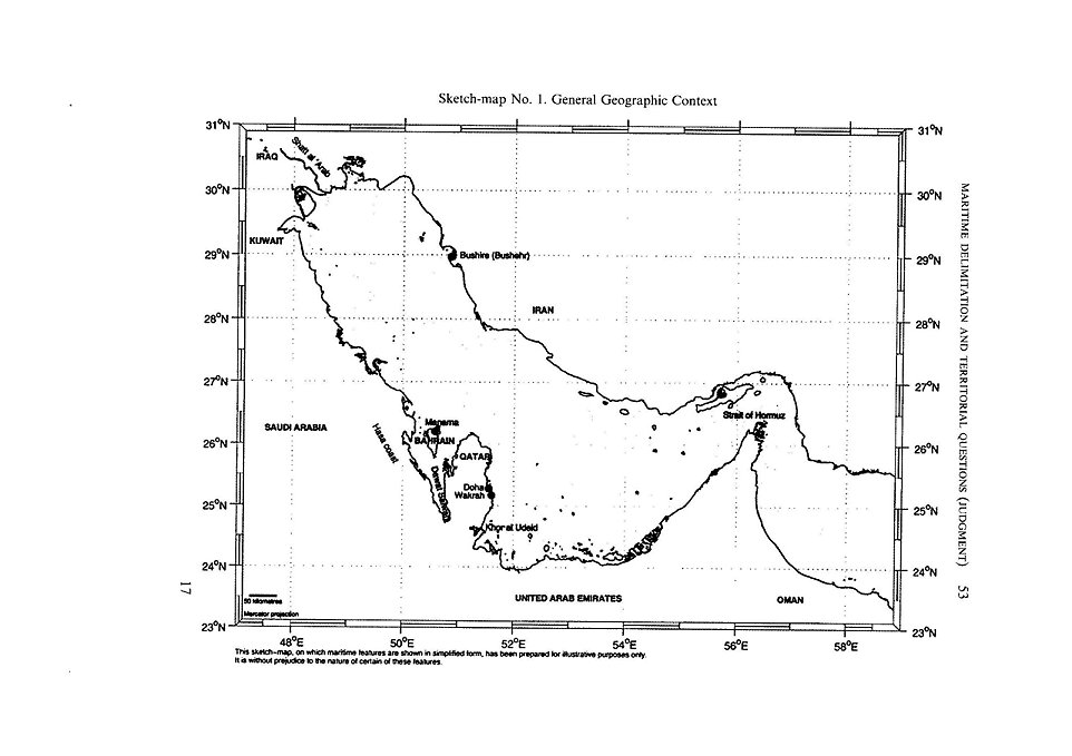
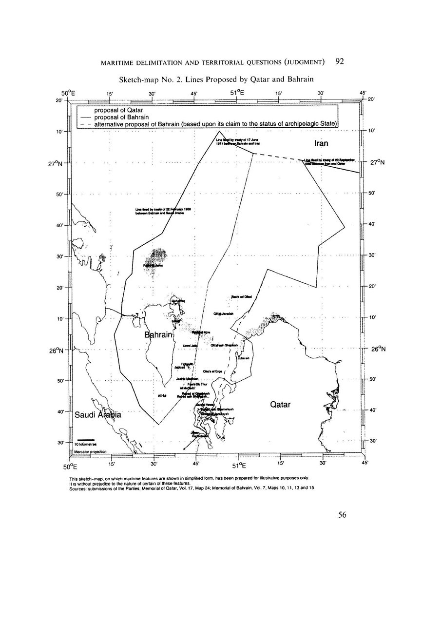
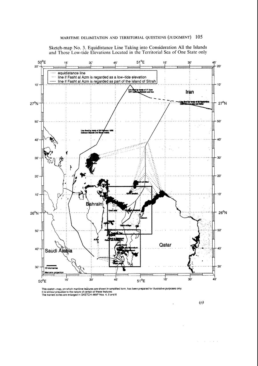
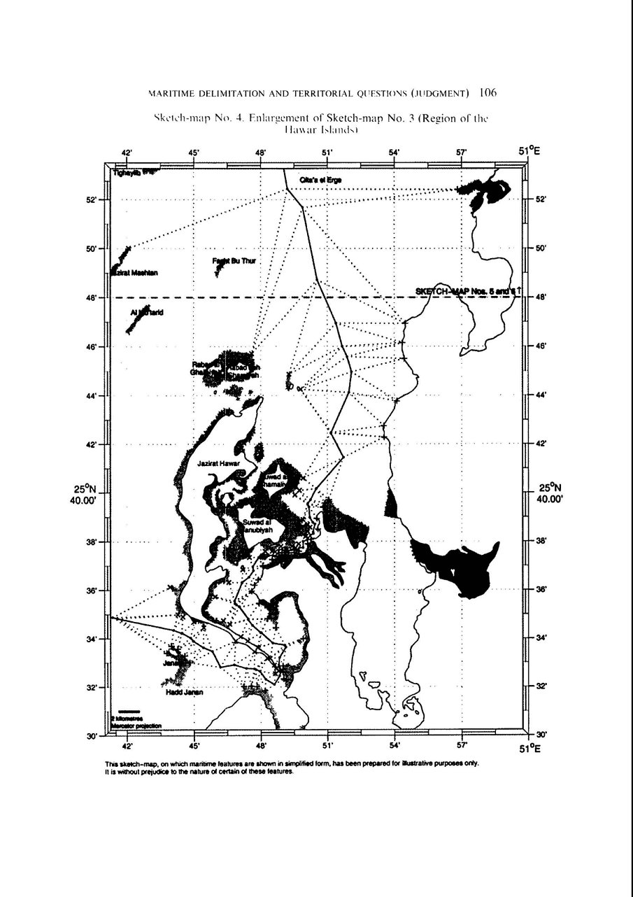
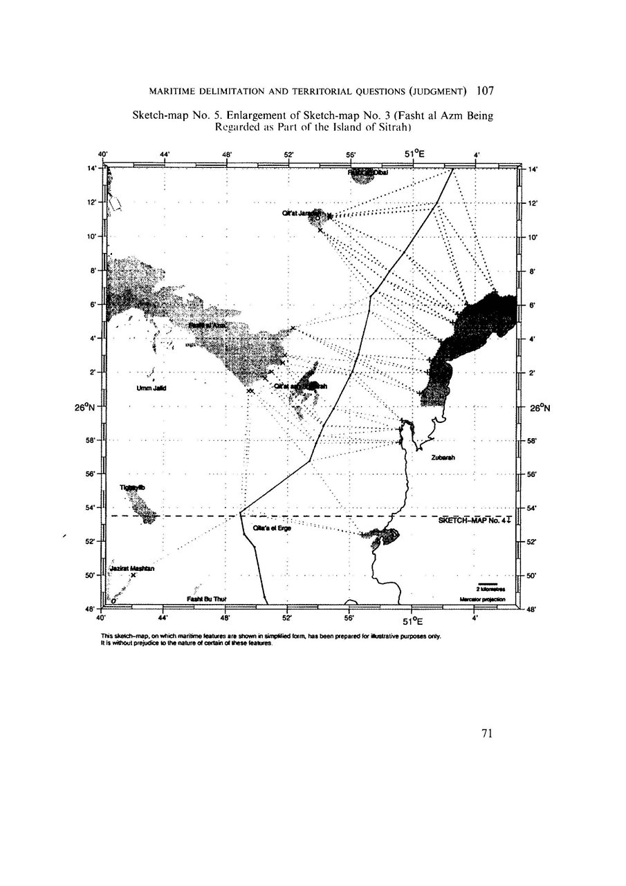
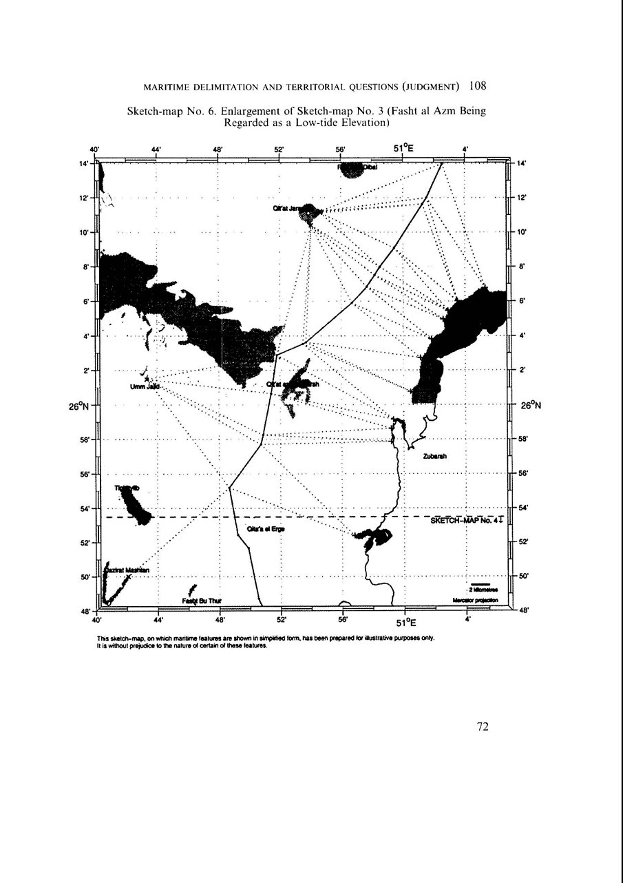