| |
[p13]
The Court,
composed as above,
after deliberation,
delivers the following Judgment:
1. By a notification dated 19 July 1982, received in the Registry of the
Court on 26 July 1982, the Secretary of the People's Committee for the
People's Foreign Liaison Bureau of the Socialist People's Libyan Arab
Jamahiriya and the Minister for Foreign Affairs of the Republic of Malta
notified the Court of a Special [p16] Agreement in the Arabic and English
languages signed at Valletta on 23 May 1976 between the Socialist People's
Libyan Arab Jamahiriya and the Republic of Malta, providing for the
submission to the Court of a dispute concerning the delimitation of the
continental shelf between those two States; a certified copy of the Special
Agreement was enclosed with the letter.
2. The authentic English text of the Special Agreement reads as follows:
"Article I
The Court is requested to decide the following question:
What principles and rules of international law are applicable to the
delimitation of the area of the continental shelf which appertains to the
Republic of Malta and the area of continental shelf which appertains to the
Libyan Arab Republic, and how in practice such principles and rules can be
applied by the two Parties in this particular case in order that they may
without difficulty delimit such areas by an agreement as provided in Article
III.
Article II
1. The proceedings shall consist of written pleadings and oral hearings.
2. Without prejudice to any question of the burden of proof, the written
pleadings shall consist of the following documents:
(a) Memorials to be submitted simultaneously to the Court by each Party and
exchanged with one another within a period of nine months from the date of
the notification of this agreement to the Registrar of the Court.
(b) Replies to be similarly submitted to the Court by each Party and
exchanged with one another within four months after the date of the
submissions of the Memorials to the Registrar.
(c) Additional written pleadings may be presented and exchanged in the same
manner within periods which shall be fixed by the Court at the request of
one of the Parties, or if the Court so decides after consultation with the
two Parties.
3. The question of the order of speaking at the oral hearings shall be
decided by mutual agreement between the Parties but in all cases the order
of speaking adopted shall be without prejudice to any question of the burden
of proof.
Article III
Following the final decision of the International Court of Justice the
Government of the Republic of Malta and the Government of the Libyan Arab
Republic shall enter into negotiations for determining the area of their
respective continental shelves and for concluding an agreement for that
purpose in accordance with the decision of the Court.
Article IV
This agreement shall enter into force on the date of exchange of instruments
of ratification by the two Governments, and shall be notified jointly to the
Registrar of the Court." [p17]
3. Pursuant to Article 40, paragraph 3, of the Statute and to Article 42 of
the Rules of Court, copies of the notification and Special Agreement were
transmitted to the Secretary-General of the United Nations, the Members of
the United Nations and other States entitled to appear before the Court.
4. Since the Court did not include upon the bench a judge of Libyan or of
Maltese nationality, each of the Parties proceeded to exercise the right
conferred by Article 31, paragraph 3, of the Statute to choose a judge ad
hoc to sit in the case. The Libyan Arab Jamahiriya designated Mr. Eduardo
Jimenez de Arechaga, and Malta designated Mr. Jorge Castaneda; on 13 October
1984 Mr. Castaneda resigned his functions for reasons of health, whereupon
Malta designated Mr. Nicolas Valticos to take his place.
5. By Orders of 27 July 1982 and 26 April 1983 respectively time-limits were
fixed for the filing of a Memorial and a Counter-Memorial by each of the two
Parties, and the Memorials and Counter-Memorials were duly filed within
those time-limits, and exchanged between the Parties through the Registrar
pursuant to the Special Agreement.
6. By an Application dated 23 October 1983 and received in the Registry of
the Court on 24 October 1983, the Government of Italy, invoking Article 62
of the Statute, submitted to the Court a request for permission to intervene
in the case. By a Judgment dated 21 March 1984, the Court found that the
application of Italy for permission to intervene could not be granted.
7. By an Order dated 21 March 1984, the President of the Court, having
regard to Article II, paragraph 2 (c), of the Special Agreement, quoted
above, fixed a time-limit for the filing of Replies, which were filed and
exchanged within the time-limit fixed.
8. On 26 to 30 November, 3 December, 6 to 7 December, 10 to 14 December
1984, and 4 to 5 February, 8 February, 11 to 13 February and 21 to 22
February 1985, the Court held public sittings at which it was addressed by
the following representatives of the Parties:
For Malta: H.E. Dr. Edgar Mizzi,
Mr. E. Lauterpacht, Q.C.,
Professor Prosper Weil,
Professor Ian Brownlie, Q.C.
For the Libyan Arab Jamahiriya: Professor El-Murtadi Suleiman,
Sir Francis Vallat, G.C.M.G., Q.C.,
Professor Herbert W. Briggs,
Professor Gunther Jaenicke,
Professor Jean-Pierre Queneudec,
Professor Claude-Albert Colliard,
Professor Laurent Lucchini,
Mr. Keith Highet,
Professor Derek W. Bowett, Q.C.
9. Professor Jan van Hinte, Dr. Derk Jongsma and Professor Icilio Finetti
were called as experts by the Libyan Arab Jamahiriya, pursuant to Articles
57 and 63 to 65 of the Rules of Court. They were examined in chief by
Professor D. W. Bowett, and Professor van Hinte was cross-examined by Mr. E.
Lauterpacht. Professor Georges Mascle and Professor Carlo Morelli were
similarly
[p18] called as experts by Malta; they were examined in chief by Mr. E. Lauterpacht, and cross-examined by Professor D. W. Bowett.
10. Previously to its application for permission to intervene, referred to
in paragraph 6 above, the Government of Italy, in reliance on Article 53,
paragraph 1, of the Rules of Court, asked to be furnished with copies of the
pleadings in the case. By a letter dated 13 October 1983, after the views of
the Parties had been sought, and objection had been raised by the Government
of Malta, the Registrar informed the Government of Italy that the Court had
decided not to grant its request. On 26 November 1984 the Court decided,
after ascertaining the views of the Parties pursuant to Article 53,
paragraph 2, of the Rules of Court, that the pleadings should be made
accessible to the public with effect from the opening of the oral
proceedings, and they were thus at the same time made available to Italy.
*
11. In the course of the written proceedings, the following submissions were
presented by the Parties:
On behalf of the Socialist People's Libyan Arab Jamahiriya,
in the Memorial: after a preamble not here quoted:
"May it please the Court, rejecting all contrary claims and submissions, to
adjudge and declare as follows:
1. The delimitation is to be effected by agreement in accordance with
equitable principles and taking account of all relevant circumstances in
order to achieve an equitable result.
2. The natural prolongation of the respective land territories of the
Parties into and under the sea is the basis of title to the areas of
continental shelf which appertain to each of them.
3. The delimitation should be accomplished in such a way as to leave as much
as possible to each Party all areas of continental shelf that constitute the
natural prolongation of its land territory into and under the sea, without
encroachment on the natural prolongation of the other.
4. A criterion for delimitation of continental shelf areas in the present
case can be derived from the principle of natural prolongation because there
exists a fundamental discontinuity in the sea-bed and subsoil which divides
the areas of continental shelf into two distinct natural prolongations
extending from the land territories of the respective Parties.
5. Equitable principles do not require that a State possessing a restricted
coastline be treated as if it possessed an extensive coastline.
6. In the particular geographical situation of this case, the application of
equitable principles requires that the delimitation should take account of
the significant difference in lengths of the respective coastlines which
face the area in which the delimitation is to be effected.
7. The delimitation in this case should reflect the element of a reasonable
degree of proportionality which a delimitation carried out in accordance
with equitable principles ought to bring about between the extent of the
continental shelf areas appertaining to the respective States and the
lengths of the relevant parts of their coasts, account being taken of any
other delimitations between States in the same region.[p19]
8. Application of the equidistance method is not obligatory, and its
application in the particular circumstances of this case would not lead to
an equitable result.
9. The principles and rules of international law can in practice be applied
by the Parties so as to achieve an equitable result, taking account of the
physical factors and all the other relevant circumstances of this case, by
agreement on a delimitation within, and following the general direction of,
the Rift Zone as defined in this Memorial";
in the Counter-Memorial and the Reply: after modified preambles not here
quoted, the submissions as presented in the Memorial were repeated.
On behalf of the Republic of Malta,
in the Memorial:
"May it please the Court to adjudge and declare that:
(i) the principles and rules of international law applicable to the
delimitation of the areas of the continental shelf which appertain to Malta
and Libya are that the delimitation shall be effected on the basis of
international law in order to achieve an equitable solution;
(ii) in practice the above principles and rules are applied by means of a
median line every point of which is equidistant from the nearest points on
the baselines of Malta, and the low-water mark of the coast of Libya";
in the Counter-Memorial and the Reply: the submissions as presented in the
Memorial were repeated and confirmed.
12. In the course of the oral proceedings, the following submissions were
presented by the Parties:
On behalf of the Socialist People's Libyan Arab Jamahiriya:
at the hearing of 22 February 1985, the final submissions of the Libyan Arab
Jamahiriya were read, which were identical with those set out in the
Memorial.
On behalf of the Republic of Malta,
at the hearing of 13 February 1985:
"May it please the Court, . . . to declare and adjudge that:
(i) the principles and rules of international law applicable to the
delimitation of the areas of the continental shelf which appertain to Malta
and Libya are that the delimitation shall be effected on the basis of
international law in order to achieve an equitable result;
(ii) in practice the above principles and rules are applied by means of a
median line every point of which is equidistant from the nearest points on
the baselines of Malta, and the low-water mark of the coasts of Libya."
*[p20]
13. Two Members of the Court (Judges Mosler and El-Khani) whose terms of
office expired under Article 13, paragraph 1, of the Statute of the Court on
5 February 1985 have continued to participate in the present proceedings in
accordance with paragraph 3 of Article 13. On 14 February 1985, the Court
elected Judge Nagendra Singh as President of the Court and Judge de
Lacharriere as Vice-President of the Court; in accordance with Article 32,
paragraph 2, of the Rules of Court, the Court as composed for the present
proceedings has continued to sit under the presidency of Judge Elias.
**
14. It is appropriate to begin with a general description of the
geographical context of the dispute before the Court, that is to say the
area in which the continental shelf delimitation, which is the subject of
the proceedings, has to be effected. It should however be emphasized that
the only purpose of the description which follows is to outline the general
background; it is not intended to define in geographical terms the area
which is relevant to the delimitation and the area in dispute between the
Parties. The question whether the area in which the delimitation is to be
effected has for any reason to be defined or contained within limits will be
examined later in this Judgment (paragraphs 20-23). Similarly, the only
purpose of Map No. 1 appended to the present Judgment is to give a general
picture of the geographical context of the dispute, and no legal
significance attaches to the choice of scale or the presence or absence of
any particular geographical feature.
15. The Republic of Malta (hereinafter called "Malta") is a State made up of
a group of four inhabited islands: Malta (246 km2 in area), Gozo (66 km2),
Comino (2.7 km2), Cominotto (less than one-tenth of a square kilometre); and
the uninhabited rock of Filfla. The 36 [degrees] N parallel passes between
the main island of Malta and the island of Gozo, which lie between the 14
[degrees] E and 15 [degrees] E meridians. The islands are situated in the
Central Mediterranean, an area of the Mediterranean Sea which may be said
broadly to be bounded by the eastern coast of Tunisia on the west, a part of
the coast of Italy, with the southern and eastern coasts of the island of
Sicily and the Ionian coast of the mainland up to the Strait of Otranto on
the north, the western coast of Greece, from the island of Corfu to the
southern tip of the Peloponnese and the island of Crete on the east, and on
the south by the coast of the Socialist People's Libyan Arab Jamahiriya
(hereinafter called "Libya"). Libya is a mainland State on the coast of
North Africa covering a large area lying mainly between the 9 [degrees] 30'
E and 25 [degrees] E meridians, and encompassing some 1,775,500 square
kilometres. The coast of Libya stretches for more than 1,700 kilometres from
Ras Ajdir in the west to near Port Bardia in the east.
16. The Maltese islands are oriented in an approximately northwest-southeast
direction, and extend for a distance of some 44.5 kilometres (24 nautical
miles). North of Malta, at a distance of some 80 kilometres (43 nautical
miles) is the island of Sicily. The southeast tip of Malta lies
approximately 340 kilometres (183 nautical miles) north of the nearest
[p21]
Map No. 1
[p22] point on the coast of Libya, and the latter point is to be found some
three-quarters of the distance along the most westerly segment of the Libyan
coast, that running from the frontier with Tunisia at Ras Ajdir, somewhat
south of east, through Ras Tajura to Ras Zarruq. At about the latter point,
the Libyan coast swings southwards, forming the western end of the Gulf of
Sirt, the coast at the back of which runs again somewhat south of east
until, at about the meridian 20 [degrees] E it swings round north and
slightly west, then round to the eastward again through Benghazi to Ras
Amir. The general line of the coast from there to the frontier with Egypt is
again somewhat south of eastwards.
17. In 1970 agreement was reached between Malta and Italy for provisional
exploitation of the continental shelf in a short section of the channel
between Sicily and Malta on each side of the median line, subject to any
adjustments that might be made in subsequent negotiations. With this
exception, neither of the Parties has yet established any agreed
delimitation of continental shelf, or other maritime areas, with any
neighbouring State. The question of the delimitation between Libya and
Tunisia has been the subject of a Judgment of the Court (Continental Shelf
(Tunisia/ Libyan Arab Jamahiriya), Judgment, I.C.J. Reports 1982, p. 18).
Delimitations in this part of the Mediterranean have been effected by
agreement between Italy and Greece, and between Italy and Tunisia. These
delimitations are indicated in Map No. 1 annexed hereto. Neither Party has
proclaimed an exclusive economic zone, but Malta has proclaimed a 25-mile
exclusive fishing zone. Malta has also defined straight baselines for the
measurement of its territorial sea relying on Article 4 of the Convention on
the Territorial Sea and the Contiguous Zone. Both Parties have granted a
number of petroleum exploration concessions extending into areas material to
the case.
**
18. The terms of the Special Agreement by which the Court was seised of the
present case have been set out in paragraph 2 of the present Judgment. The
question which the Court is requested to decide is there defined as follows:
"What principles and rules of international law are applicable to the
delimitation of the area of the continental shelf which appertains to the
Republic of Malta and the area of continental shelf which appertains to the
Libyan Arab Republic, and how in practice such principles and rules can be
applied by the two Parties in this particular case in order that they may
without difficulty delimit such areas by an agreement as provided in Article
III."
The first part of the request is thus intended to resolve the differences
between the Parties regarding the principles and rules of international law
which are applicable in the present case; there is in this case no
divergence [p23] of views between the Parties as to the task to be
performed by the Court. As to the second part of the request, by which the
Parties have asked the Court to indicate how the applicable principles and
rules can, in practice, be applied by the Parties, in order that they may,
without difficulty, establish by an agreement the delimitation of their
continental shelves, it has been stated before
the Court that the wording of the Special Agreement in this respect was a
compromise formula. Malta had wished the Court to be asked to draw the
delimitation line, while Libya wanted it to be requested only to pronounce
on the principles and rules of international law applicable. Libya would not
accept that the line itself should be drawn by the Court since, in its view,
it was preferable that this be done by agreement between the Parties. Malta
did not agree that the matter be left to the Parties since it is of the view
that the reference of the dispute to the Court would then fail to achieve
its main purpose. While the Special Agreement as adopted does not request
the Court itself to draw the line of delimitation between the areas of
continental shelf appertaining to each Party, Malta, relying on the
interpretation by the Court of the similarly worded Special Agreement in the
case concerning the Continental Shelf (Tunisia/Libyan Arab Jamahiriya),
contends that "the Court should indicate the boundary which, in its view,
would result from the application of such method as the Court may choose for
the Parties to achieve the relevant determination". Malta emphasizes the
purpose of the proceedings as being to enable the Parties to effect the
delimitation "without difficulty", which could not, it argues, be achieved
unless the Court were to state in the clearest possible terms how the
exercise is to be carried out. Malta's submissions, accordingly, request a
finding by the Court that the appropriate principles and rules are in
practice to be applied by means of a specific line (a median line). Libya on
the other hand maintains that the task of the Court in the present case does
not extend so far as the actual determination of the delimitation line, and
it need not specify or particularize one method of delimitation or one way
by which in practice the principles and rules can be applied; in Libya's
view the goal to be reached is the result which would be in accord with
equitable principles and represent the most appropriate application of the
existing principles and rules of international law. Accordingly, the
submissions of Libya refer in broad terms to a delimitation by agreement on
the basis of the Court's Judgment "within, and following the general
direction of", a particular sea-bed area defined in the Libyan Memorial; it
is explained that in its pleadings
"Libya did not advance a precise line, since the Court's task is not to
determine a precise line".
19. Since the jurisdiction of the Court derives from the Special Agreement
between the Parties, the definition of the task so conferred upon it is
primarily a matter of ascertainment of the intention of the Parties by
interpretation of the Special Agreement. The Court must not exceed the
jurisdiction conferred upon it by the Parties, but it must also exercise
that jurisdiction to its full extent. The Special Agreement, unlike that by
which the Court was seised in the Tunisia/Libya case, contains no reference
to the [p24] indication of a method or methods of delimitation; but since
the Court is required to decide how in practice the principles and rules of
international law can be applied in order that the Parties may delimit the
continental shelf by agreement "without difficulty", this necessarily
entails the indication by the Court of the method or methods which it
considers to result from the proper application of the appropriate rules and
principles. Whether the Court should indicate an actual delimitation line
will in some degree depend upon the method or methods found applicable: if,
for example, the Court were to find that the equidistance method is required
by the applicable law in the circumstances of this case, its finding to that
effect would in fact dictate the delimitation line, since the nature of that
method is such that any given set of basepoints will generate only one
possible equidistance line. Other methods, however, less automatic in their
operation, might require to be backed by more detailed indications of
criteria by the Court, if the objective of an agreed delimitation reached
"without difficulty" is to be achieved. The Court does not in any event
consider that it is debarred by the terms of the Special Agreement from
indicating a line. Even Libya, which contends that the task of the Court in
the present case does not extend so far as the actual determination of the
delimitation line, did in fact itself indicate on the map two possible lines
for the purpose of illustrating a possible method which it considered would
be likely to produce an equitable result. It should also be noted that both
Parties have indicated that the consequences of the application of any
method initially adopted are to be tested against certain criteria in order
to check the equitableness of the result. It is not apparent how this
operation could be performed unless that result took the form of at least an
approximate line which could be illustrated on a map.
20. The delimitation contemplated by the Special Agreement is of course
solely that between the areas of continental shelf appertaining to the
Parties. It is no part of the task of the Court to define the legal
principles and rules applicable to any delimitation between one or other of
the Parties and any third State, let alone to indicate the practical
application of those principles and rules to such delimitation. The Court is
in fact aware of the existence of specific claims by a third State to areas
which are also claimed by the Parties: these are the claims of Italy, which
in 1984 made an application to the Court for permission to intervene under
Article 62 of the Statute of the Court, and outlined to the Court in the
course of the proceedings on that request the extent of its continental
shelf claims in the direction of Libya and Malta. In its Judgment of 21
March 1984, by which it found that the Italian Application could not be
granted, the Court explained that it "cannot wholly put aside the question
of the legal interest of Italy as well as of other States of the
Mediterranean region, and they will have to be taken into account" (I.C.J.
Reports 1984, p. 25, para. 41). In the geographical context of the case it
is also possible that there might be conflict between the claims of the
Parties and such claims as may be made by Tunisia, though the Court has not
been furnished with any information as to the views of that State as to its
own entitlement vis-ŕ-vis Malta. The [p25] Parties agree, however, as
concerns the extent of the Court's decision, in contending that the Court
should not feel inhibited from extending its decision to all areas which,
independently of third party claims, are claimed by the Parties to this
case, since if the Court were to exclude any such areas as are the subject
of present or possible future claims by a third State it would in effect be
deciding on such claims without jurisdiction to do so. Libya draws a
distinction: the areas in which there are no claims by third States are the
areas primarily in focus for the present proceedings and here the Parties
can proceed to a definitive delimitation, whereas in areas where there are
such claims, the caveats and reservations which the Court would include in
its judgment would protect the rights of third States by precluding such a
delimitation being definitive vis-ŕ-vis such third States. Malta rejects
this distinction, arguing that it would have no practical purpose and would
be objectionable on jurisdictional grounds.
21. The Court notes that by the Special Agreement it is asked to define the
legal principles and rules applicable to the delimitation of the area of
continental shelf "which appertains" to each of the Parties. The decision of
the Court will, by virtue of Article 59 of the Statute, have binding force
between the Parties, but not against third States. If therefore the decision
is to be stated in absolute terms, in the sense of permitting the
delimitation of the areas of shelf which "appertain" to the Parties, as
distinct from the areas to which one of the Parties has shown a better title
than the other, but which might nevertheless prove to "appertain" to a third
State if the Court had jurisdiction to enquire into the entitlement of that
third State, the decision must be limited to a geographical area in which no
such claims exist. It is true that the Parties have in effect invited the
Court, notwithstanding the terms of their Special Agreement, not to limit
its judgment to the area in which theirs are the sole competing claims; but
the Court does not regard itself as free to do so, in view of the interest
of Italy in the proceedings. When rejecting the application of Italy to
intervene in the proceedings, the Court noted that both Malta and Libya
opposed that application; while it stated that in its final judgment in this
case
"the Court will, so far as it may find it necessary to do so, make it clear
that it is deciding only between the competing claims of Libya and Malta",
it also went on to observe that:
"If, as Italy has suggested, the decision of the Court in the present case,
taken without Italy's participation, had for that reason to be more limited
in scope between the Parties themselves, and subject to more caveats and
reservations in favour of third States, than it might otherwise have been
had Italy been present, it is the interests of Libya and Malta which might
be said to be affected, not those of Italy. It is material to recall that
Libya and Malta, by objecting to the intervention of Italy, have indicated
their own preferences." (I.C.J. Reports 1984, p. 27, para. 43.) [p26]
The present decision must, as then foreshadowed, be limited in geographical
scope so as to leave the claims of Italy unaffected, that is to say that the
decision of the Court must be confined to the area in which, as the Court
has been informed by Italy, that State has no claims to continental shelf
rights. The Court, having been informed of Italy's claims, and having
refused to permit that State to protect its interests through the procedure
of intervention, thus ensures Italy the protection it sought. A decision
limited in this way does not signify either that the principles and rules
applicable to the delimitation within this area are not applicable outside
it, or that the claims of either Party to expanses of continental shelf
outside that area have been found to be unjustified: it signifies simply
that the Court has not been-endowed with jurisdiction to determine what
principles and rules govern delimitations with third States, or whether the
claims of the Parties outside that area prevail over the claims of those
third States in the region.
22. The limits within which the Court, in order to preserve the rights of
third States, will confine its decision in the present case, may thus be
defined in terms of the claims of Italy, which are precisely located on the
map by means of geographical co-ordinates. During the proceedings held on
its application for permission to intervene, Italy stated that it considered
itself to have rights over a geographical zone delimited on the west by the
meridian 15 [degrees] 10' E, to the south by the parallel 34 [degrees] 30'
N. to the east by the delimitation line agreed between Italy and Greece (see
Map No. 1) and its prolongation, and to the north by the Italian coasts of
Calabria and Apulia; and over a second area delimited by lines joining the
following points: (i) the south-eastern end-point of the line defined in the
Agreement between Italy and Tunisia of 20 August 1971, (ii) points X and G,
shown on a map submitted to the Court on 25 January 1984, (iii) the point 34
[degrees] 20'N and 13 [degrees] 50' E, and (iv) the point located on the
meridian 13 [degrees] 50' E, to the north of the previous point and to the
east of the end-point mentioned under (i). These areas are shown on Map No.
2 appended hereto. The Court, in replying to the question put to it in the
Special Agreement as to the principles and rules of international law
applicable to the delimitation of the areas of continental shelf
appertaining to each of the Parties, will confine itself to areas where no
claims by a third State exist, that is to say, the area between the
meridians 13 [degrees] 50' E and 15 [degrees] 10' E. The Court notes that
there is on the east of this a further area of continental shelf, lying
south of the parallel 34 [degrees] 30' N, to which the claims of Italy do
not extend but which is subject to conflicting claims by Libya and Malta.
However the Court does not think that it is enabled to pass judgment on this
area so long as the national attribution of the continental shelf lying
immediately to the north of it (that is, east of the meridian 15 [degrees]
10' E and north of the parallel 34 [degrees] 30' N) has not been settled by
agreement between the States concerned or by the decision of a competent
organ. The Court therefore concludes that on the basis of the geographical
definition of the claims of Italy it should limit the area within which it
will give a decision by [27]
Map No. 2
[p28] the meridian 15 [degrees] 10' E, including
also that part of that meridian which is south of the parallel 34 [degrees]
30' N. No question of this kind arises to the west of the meridian 13
[degrees] 50' E, since the southward limit of Italian claims is the same as
that of the claims of Malta; the area to the south is thus not in dispute in
this case.
23. It has been questioned whether it is right that a third State -- in this
case, Italy -- should be enabled, by virtue of its claims, to restrict the
scope of a judgment requested of the Court by Malta and Libya; and it may
also be argued that this approach would have prevented the Court from giving
any judgment at all if Italy had advanced more ambitious claims. However, to
argue along these lines is to disregard the special features of the present
case. On the one hand, no inference can be drawn from the fact that the
Court has taken into account the existence of Italian claims as to which it
has not been suggested by either of the Parties that they are obviously
unreasonable. On the other hand, neither Malta nor Libya seems to have been
deterred by the probability of the Court's judgment being restricted in
scope as a consequence of the Italian claims. The prospect of such a
restriction did not persuade these countries to abandon their opposition to
Italy's application to intervene; as noted in paragraph 21 above, the Court
observed, in its Judgment of 21 March 1984, that in expressing a negative
opinion on the Italian application, the two countries had shown their
preference for a restriction in the geographical scope of the judgment which
the Court was to give.
**
24. The history of the dispute, and of the legislative and exploratory
activities in relation to the continental shelf, do not require to be set
out at length, since the Court does not find that anything of moment turns
on considerations derived from this history. It is not argued by either
Party that the circumstances in this case gave rise to "the appearance on
the map of a de facto line dividing concession areas which were the subject
of active claims", which might be taken into account as indicating "the line
or lines which the Parties themselves may have considered equitable or acted
upon as such", as the Court was able to find in the case concerning the
Continental Shelf (Tunisia/Libyan Arab Jamahiriya) (I.C.J. Reports 1982, p.
84, paras. 117-118). In its pleadings, however, Malta recounted how it had
in 1965 informed Libya of its intention to delimit its continental shelf by
means of a median line, and stated that until Libya made a counterproposal
in 1973, Libya remained silent in face of Malta's claim to such a
delimitation; Malta contended that this pattern of conduct could be viewed
"either as a cogent reflection of the equitable character of Malta's
position or as evidence of acquiescence by Libya in Malta's position or as
precluding Libya, in law as in fact, from challenging the validity of
Malta's position". Malta referred also to the question of the northern
boundaries of certain Libyan concessions, and the exemption of the licencees
from the duty to carry out petroleum activities north of the median line,
and con-[p29] tended that these also confirmed Malta's submission that "by
their conduct, the Parties have indicated that the median line is, to say
the least, very relevant to the final determination of the boundary in the
present case". Libya disputes the allegation of acquiescence; it has also
contended that Maltese petroleum concessions followed geomorphological
features in a manner consistent with the "exploitability criterion", which
is denied by Malta. It also contended that Malta, at the time of the
enactment of its 1966 Continental Shelf Act, implicitly recognized the
significance of an area described as the "rift zone" area, which Libya, as
will be explained below, regards as significant for the delimitation; this
contention Malta also rejects.
25. The Court has considered the facts and arguments brought to its
attention in this respect, particularly from the standpoint of its duty to
"take into account whatever indicia are available of the [delimitation] line
or lines which the Parties themselves may have considered equitable or acted
upon as such" (I.C.J. Reports 1982, p. 84, para. 118). It is however unable
to discern any pattern of conduct on either side sufficiently unequivocal to
constitute either acquiescence or any helpful indication of any view of
either Party as to what would be equitable differing in any way from the
view advanced by that Party before the Court. Its decision must accordingly
be based upon the application to the submissions made before it of
principles and rules of international law.
**
26. The Parties are broadly in agreement as to the sources of the law
applicable in this case. Malta is a party to the 1958 Geneva Convention on
the Continental Shelf, while Libya is not; the Parties agree that the
Convention, and in particular the provisions for delimitation in Article 6,
is thus not as such applicable in the relations between them. Both Parties
have signed the 1982 United Nations Convention on the Law of the Sea, but
that Convention has not yet entered into force, and is therefore not
operative as treaty-law; the Special Agreement contains no provisions as to
the substantive law applicable. Nor are there any other bilateral or
multilateral treaties claimed to be binding on the Parties. The Parties thus
agree that the dispute is to be governed by customary international law.
This is not at all to say, however, that the 1982 Convention was regarded by
the Parties as irrelevant: the Parties are again in accord in considering
that some of its provisions constitute, to a certain extent, the expression
of customary international law in the matter. The Parties do not however
agree in identifying the provisions which have this status, or the extent to
which they are so treated.
27. It is of course axiomatic that the material of customary international
law is to be looked for primarily in the actual practice and opinio juris of
States, even though multilateral conventions may have an important role to
play in recording and defining rules deriving from custom, or indeed in [p30] developing them. There has in fact been much debate between the Parties
in the present case as to the significance, for the delimitation of -- and
indeed entitlement to -- the continental shelf, of State practice in the
matter, and this will be examined further at a later stage in the present
judgment. Nevertheless, it cannot be denied that the 1982 Convention is of
major importance, having been adopted by an overwhelming majority of States;
hence it is clearly the duty of the Court, even independently of the
references made to the Convention by the Parties, to consider in what degree
any of its relevant provisions are binding upon the Parties as a rule of
customary international law. In this context particularly, the Parties have
laid some emphasis on a distinction between the law applicable to the basis
of entitlement to areas of continental shelf -- the rules governing the
existence, "ipso jure and ab initio", and the exercise of sovereign rights
of the coastal State over areas of continental shelf situate off its coasts
-- and the law applicable to the delimitation of such areas of shelf between
neighbouring States. The first question is dealt with in Article 76 of the
1982 Convention, and the second in Article 83 of the Convention. Paragraph 1
of that Article provides that:
"The delimitation of the continental shelf between States with opposite or
adjacent coasts shall be effected by agreement on the basis of international
law, as referred to in Article 38 of the Statute of the International Court
of Justice, in order to achieve an equitable solution."
Paragraph 10 of Article 76 provides that "The provisions of this article are
without prejudice to the question of delimitation of the continental shelf
between States with opposite or adjacent coasts". That the questions of
entitlement and of definition of continental shelf, on the one hand, and of
delimitation of continental shelf on the other, are not only distinct but
are also complementary is self-evident. The legal basis of that which is to
be delimited, and of entitlement to it, cannot be other than pertinent to
that delimitation.
28. At this stage of the present Judgment, the Court would also first recall
that, as it noted in its Judgment in the case concerning the Continental
Shelf (Tunisia/Libyan Arab Jamahiriya),
"In the new text, any indication of a specific criterion which could give
guidance to the interested States in their effort to achieve an equitable
solution has been excluded. Emphasis is placed on the equitable solution
which has to be achieved. The principles and rules applicable to the
delimitation of continental shelf areas are those which are appropriate to
bring about an equitable result . . ." (I.C.J. Reports 1982, p. 49, para.
50.)
The Convention sets a goal to be achieved, but is silent as to the method to
be followed to achieve it. It restricts itself to setting a standard, and it
is left to States themselves, or to the courts, to endow this standard with
specific [p31] content. Secondly, the Court in 1982 observed the
disappearance, in the last draft text of what became Article 83, paragraph
1, of reference to delimitation by agreement "in accordance with equitable
principles" (I.C.J. Reports 1982, p. 49, para. 49). It found however that it
was "bound to decide the case on the basis of equitable principles" as well
as that "The result of the application of equitable principles must be
equitable" (ibid., p. 59, para. 70).
29. In the present case, both Parties agree that, whatever the status of
Article 83 of the 1982 Convention, which refers only to the "solution" as
being equitable, and does not specifically mention the application of
equitable principles, both these requirements form part of the law to be
applied. In the first of Libya's submissions, the Court is asked to declare
that
"The delimitation is to be effected by agreement in accordance with
equitable principles and taking account of all relevant circumstances in
order to achieve an equitable result."
The first submission of Malta reads:
"the principles and rules of international law applicable to the
delimitation of the areas of the continental shelf which appertain to Malta
and Libya are that the delimitation shall be effected on the basis of
international law in order to achieve an equitable result".
The Agent of Malta confirmed that Malta also accepts that the delimitation
is to be effected in accordance with equitable principles and taking account
of all relevant circumstances.
30. It is however with regard to the legal basis of title to continental
shelf rights that the views of the Parties are irreconcilable; for Libya,
"The natural prolongation of the respective land territories of the Parties
into and under the sea is the basis of title to the areas of continental
shelf which appertain to each of them." (Submission No. 2.)
In Libya's view, the prolongation of the land territory of a State into and
under the sea, referred to by the Court in the North Sea Continental Shelf
cases (I.C.J. Reports 1969, p. 31, para. 43), was a "geological fact" and
natural prolongation in the same physical sense, involving geographical as
well as geological and geomorphological aspects, remains the fundamental
basis of legal title to continental shelf areas. For Malta, while it is
still true to say that the continental shelf of a State constitutes a
natural prolongation of its land territory into and under the sea,
prolongation is no longer defined by reference to physical features,
geological or bathymetric, but by reference to a certain distance from the
coasts. The concept of natural prolongation has in Malta's view become a
purely spatial concept which operates independently of all geomorphological
or geological characteris-[p32] tics, only resuming a physical significance
beyond 200 miles from the coast, since States which possess a more extensive
physical natural prolongation enjoy continental shelf rights to the edge of
their continental margin. For Malta, the principle is the application of the
"distance criterion"; continental shelf rights, whether extending without
restraint into the open sea or limited by reference to a neighbouring State,
are controlled by the concept of distance from the coasts.
31. In this connection the question arises of the relationship, both within
the context of the 1982 Convention and generally, between the legal concept
of the continental shelf and that of the exclusive economic zone. Malta
relies on the genesis of the exclusive economic zone concept, and its
inclusion in the 1982 Convention, as confirming the importance of the
"distance principle" in the law of the continental shelf and the detachment
of the concept of the shelf from any criterion of physical prolongation.
Malta has submitted that, in the present delimitation, account must be taken
of the rules of customary law reflected in Article 76 of the Convention in
the light of the provisions of the Convention concerning the exclusive
economic zone. Malta's opinion is based on the statement made on this point
by the Court itself in its 1982 Judgment, that "the definition given in
paragraph 1 [of Article 76] cannot be ignored" and that the exclusive
economic zone "may be regarded as part of modern international law" (I.C.J.
Reports 1982, p. 48, para. 47 and p. 74, para. 100). For Malta, the
"distance principle", referred to also by the Court itself, is accordingly
included among the principles and rules of customary international law and
should be taken into account. Malta emphasizes the development of the law in
this field, and recalls that in its 1982 Judgment the Court stated: "the
concept of natural prolongation . . . was and remains a concept to be
examined within the concept of customary law and State practice" (ibid., p.
46, para. 43).
32. Libya, on the other hand, points out that this case is concerned only
with the delimitation of the continental shelf, and emphasizes that the 1982
Convention has not yet come into force and is not binding as between the
Parties to the present case. It contends that the "distance principle" is
not a rule of positive international law with regard to the continental
shelf, and that the "distance criterion", which may be applicable to the
definition of the outer limit of the continental shelf in certain
circumstances, if it applies at all to delimitation, is inappropriate for
application in the Mediterranean. It is Libya's contention that the
continental shelf has not been absorbed by the concept of the exclusive
economic zone under present international law; and that the establishment of
fishery zones and exclusive economic zones has not changed the law of
maritime zone delimitation, or given more prominence to the criterion of
distance from the coast. It also argues that, whereas the rights of the
coastal State over its continental shelf are inherent and ab initio, rights
over the exclusive economic zone exist only in so far as the coastal State
chooses to proclaim such a zone. For Libya, the 1982 Convention on the Law
of the Sea, particularly [p33] Article 78, maintains the dissociation of
the legal regime of the continental shelf, the sea-bed and subsoil, from the
regime of the superjacent waters.
33. In the view of the Court, even though the present case relates only to
the delimitation of the continental shelf and not to that of the exclusive
economic zone, the principles and rules underlying the latter concept cannot
be left out of consideration. As the 1982 Convention demonstrates, the two
institutions -- continental shelf and exclusive economic zone -- are linked
together in modern law. Since the rights enjoyed by a State over its
continental shelf would also be possessed by it over the sea-bed and subsoil
of any exclusive economic zone which it might proclaim, one of the relevant
circumstances to be taken into account for the delimitation of the
continental shelf of a State is the legally permissible extent of the
exclusive economic zone appertaining to that same State. This does not mean
that the concept of the continental shelf has been absorbed by that of the
exclusive economic zone; it does however signify that greater importance
must be attributed to elements, such as distance from the coast, which are
common to both concepts.
34. For Malta, the reference to distance in Article 76 of the 1982
Convention represents a consecration of the "distance principle"; for Libya,
only the reference to natural prolongation corresponds to customary
international law. It is in the Court's view incontestable that, apart from
those provisions, the institution of the exclusive economic zone, with its
rule on entitlement by reason of distance, is shown by the practice of
States to have become a part of customary law; in any case, Libya itself
seemed to recognize this fact when, at one stage during the negotiation of
the Special Agreement, it proposed that the extent of the exclusive economic
zone be included in the reference to the Court. Although the institutions of
the continental shelf and the exclusive economic zone are different and
distinct, the rights which the exclusive economic zone entails over the
sea-bed of the zone are defined by reference to the regime laid down for the
continental shelf. Although there can be a continental shelf where there is
no exclusive economic zone, there cannot be an exclusive economic zone
without a corresponding continental shelf. It follows that, for juridical
and practical reasons, the distance criterion must now apply to the
continental shelf as well as to the exclusive economic zone; and this quite
apart from the provision as to distance in paragraph 1 of Article 76. This
is not to suggest that the idea of natural prolongation is now superseded by
that of distance. What it does mean is that where the continental margin
does not extend as far as 200 miles from the shore, natural prolongation,
which in spite of its physical origins has throughout its history become
more and more a complex and juridical concept, is in part defined by
distance from the shore, irrespective of the physical nature of the
intervening sea-bed and subsoil. The concepts of natural prolongation and
distance are therefore not opposed but complementary; and both remain
essential elements in the juridical concept of the continental shelf. As the
[p34] Court has observed, the legal basis of that which is to be delimited
cannot be other than pertinent to the delimitation (paragraph 27, supra);
the Court is thus unable to accept the Libyan contention that distance from
the coast is not a relevant element for the decision of the present case.
**
35. It will now be convenient in view of this conclusion to examine two
important and opposed arguments of the Parties: first the Libyan "rift-zone"
argument, which depends upon giving primacy to the idea of natural
prolongation, in the physical sense; and second, the argument of Malta that,
on the contrary, it is distance that is now the prime element; and that, in
consequence of this, equidistance, at least between opposite coasts, is
virtually a required method, if only as the first stage in a delimitation.
36. As noted above, it is Libya's case that the natural prolongation, in the
physical sense, of the land territory into and under the sea is still a
primary basis of title to continental shelf. For Libya, as a first step each
Party has to prove that the physical natural prolongation of its land
territory extends into the area in which the delimitation is to be effected;
if there exists a fundamental discontinuity between the shelf area adjacent
to one Party and the shelf area adjacent to the other, then the boundary, it
is contended, should lie along the general line of that fundamental
discontinuity. The delimitation of continental shelf between Libya and Malta
must therefore respect the alleged existence of a fundamental discontinuity
which, according to Libya, divides the areas of physical continental shelf
appertaining to each of the Parties (see final submissions 2 and 4). The
argument is thus that there is no problem of overlapping shelves, but that,
on the contrary, two distinct continental shelves are separated by what
Libya calls the "rift zone".
37. The sea-bed area so referred to by Libya lies broadly to the south and
south-west of the Maltese islands, and much closer to them than to the
coasts of Libya. In this area is a series of deep troughs, running in a
generally northwest-southeast direction, and reaching over 1,000 metres in
depth, described on the International Bathymetric Chart of the Mediterranean
as the "Malta Trough", the "Pantelleria Trough" and the "Linosa Trough". To
the east of these troughs, and running in broadly the same direction, are
two channels of lesser depth designated the "Malta Channel" and the "Medina
Channel". This "rift zone" area lies towards the northern extremity of the
Pelagian Block, which the Court had occasion to examine in the Tunisia/Libya
case in 1982. It should also be noted that to the east of the Pelagian Block
is an area called by Libya the "Escarpment-Fault Zone", to which Libya also
attributes importance; however, the argument based upon it appears to the
Court to be distinct from that concerning the "rift zone", and since the
"Escarpment-Fault Zone" is beyond the limits, defined in paragraph 22 above,
within which the present Judgment oper-[p35] ates, it will not be further
referred to, and the Court will express no view as to the validity of the
arguments based upon it.
38. The Court was furnished by both Parties with considerable expert
evidence, both written and oral, as to the geological history and nature of
the area described as the "rift zone", on the basis of which it was
contended by Libya, and controverted by Malta, that the rift zone indicated
the boundary zone between Libya's entitlement to areas of continental shelf
to the north of the Libyan landmass and Malta's entitlement to areas of
continental shelf to the south of the Maltese islands, either as
constituting geologically a boundary between two tectonic plates, or simply
as a geomorphological feature of such importance as to constitute a very
marked discontinuity. Since, however, this discontinuity is not a line but a
zone, Libya allows that there remains a problem of delimitation confined to
this "rift zone", to be settled by negotiation between the Parties, in
implementation of Article III of the Special Agreement.
39. The Court however considers that since the development of the law
enables a State to claim that the continental shelf appertaining to it
extends up to as far as 200 miles from its coast, whatever the geological
characteristics of the corresponding sea-bed and subsoil, there is no reason
to ascribe any role to geological or geophysical factors within that
distance either in verifying the legal title of the States concerned or in
proceeding to a delimitation as between their claims. This is especially
clear where verification of the validity of title is concerned, since, at
least in so far as those areas are situated at a distance of under 200 miles
from the coasts in question, title depends solely on the distance from the
coasts of the claimant States of any areas of sea-bed claimed by way of
continental shelf, and the geological or geomorphological characteristics of
those areas are completely immaterial. It follows that, since the distance
between the coasts of the Parties is less that 400 miles, so that no
geophysical feature can lie more than 200 miles from each coast, the feature
referred to as the "rift zone" cannot constitute a fundamental discontinuity
terminating the southward extension of the Maltese shelf and the northward
extension of the Libyan as if it were some natural boundary.
40. Neither is there any reason why a factor which has no part to play in
the establishment of title should be taken into account as a relevant
circumstance for the purposes of delimitation. It is true that in the past
the Court has recognized the relevance of geophysical characteristics of the
area of delimitation if they assist in identifying a line of separation
between the continental shelves of the Parties. In the North Sea Continental
Shelf cases the Court said:
"it can be useful to consider the geology of that shelf in order to [p36]
find out whether the direction taken by certain configurational features
should influence delimitation because, in certain localities, they point-up
the whole notion of the appurtenance of the continental shelf to the State
whose territory it does in fact prolong" (I.C.J. Reports 1969, p. 51, para.
95).
Again, in the Tunisia/Libya case of 1982, the Court recognized that:
"identification of natural prolongation may, where the geographical
circumstances are appropriate, have an important role to play in defining an
equitable delimitation, in view of its significance as the justification of
continental shelf rights in some cases" (I.C.J. Reports 1982, p. 47, para.
44),
and the Court remarked also that "a marked disruption or discontinuance of
the sea-bed" may constitute "an indisputable indication of the limits of two
separate continental shelves, or two separate natural prolongations" (ibid.
p. 57, para. 66). However to rely on this jurisprudence would be to overlook
the fact that where such jurisprudence appears to ascribe a role to
geophysical or geological factors in delimitation, it finds warrant for
doing so in a regime of the title itself which used to allot those factors a
place which now belongs to the past, in so far as sea-bed areas less than
200 miles from the coast are concerned.
41. These juridical difficulties of the rift-zone argument are conclusive
against it. Even had this not been so. there would still have been
difficulties concerning the interpretation of the evidence itself. Having
carefully studied that evidence, the Court is not satisfied that it would be
able to draw any sufficiently cogent conclusions from it as to the existence
or not of the "fundamental discontinuity" on which the Libyan argument
relies. Doubtless the region has many geological or geomorphological
features which may properly be described in scientific terms as
"discontinuities". The endeavour, however, in the terms of the Libyan
argument, was to convince the Court of a discontinuity so scientifically
"fundamental", that it must also be a discontinuity of a natural
prolongation in the legal sense; and such a fundamental discontinuity was
said to be constituted by a tectonic plate boundary which the distinguished
scientists called by Libya detected in the rift zone, or at least by the
presence there of a very marked geomorphological feature. However the no
less distinguished scientists called by Malta testified that this supposed
"secondary" tectonic plate boundary was only an hypothesis, and that the
data at present available were quite insufficient to prove, or indeed to
disprove, its existence. The Court is unable to accept the position that in
order to decide this case, it must first make a determination upon a
disagreement between scientists of distinction as to the more plausibly
correct interpretation of apparently incomplete scientific data; for a
criterion that depends upon such a judgment or estimate having to be made by
a court, or perhaps also by negotiating governments, is clearly inapt to a
general legal rule of delimit-[p37] tation. For all the above reasons, the
Court, therefore, rejects the so-called rift-zone argument of Libya.
*
42. Neither, however, is the Court able to accept the argument of Malta --
almost diametrically opposed to the Libyan rift-zone argument -- that the
new importance of the idea of distance from the coast has, at any rate for
delimitation between opposite coasts, in turn conferred a primacy on the
method of equidistance. As already noted, Malta rejects the view that
natural prolongation in the physical sense is the basis of title of the
coastal State, and bases its approach to continental shelf delimitation on
the "distance principle": each coastal State is entitled to continental
shelf rights to a certain distance from its coast, whatever may be the
physical characteristics of the sea-bed and subsoil. Since there is not
sufficient space between the coasts of Malta and Libya for each of them to
enjoy continental shelf rights up to the full 200 miles recognized by
international law, the delimitation process must, according to Malta,
necessarily begin by taking into consideration an equidistance line between
the two coasts. The delimitation of the continental shelf must start from
the geographical facts in each particular case; Malta regards the situation
as one of two coastal States facing each other in an entirely normal
setting. Malta does not assert that the equidistance method is fundamental,
or inherent, or has a legally obligatory character. It does argue that the
legal basis of continental shelf rights -- that is to say, for Malta, the
"distance principle" -- requires that as a starting point of the
delimitation process consideration must be given to a line based on
equidistance; though it is only to the extent that this primary delimitation
produces an equitable result by a balancing up of the relevant circumstances
that the boundary coincides with the equidistance line. As a provisional
point of departure, consideration of equidistance "is required" on the basis
of the legal title.
43. The Court is unable to accept that, even as a preliminary and
provisional step towards the drawing of a delimitation line, the
equidistance method is one which must be used, or that the Court is
"required, as a first step, to examine the effects of a delimitation by
application of the equidistance method" (I.C.J. Reports 1982, p. 79, para.
110). Such a rule would come near to an espousal of the idea of "absolute
proximity", which was rejected by the Court in 1969 (see I.C.J. Reports
1969, p. 30, para. 41), and which has since, moreover, failed of acceptance
at the Third United Nations Conference on the Law of the Sea. That a coastal
State may be entitled to continental shelf rights by reason of distance from
the coast, and irrespective of the physical characteristics of the
intervening sea-bed [p38] and subsoil, does not entail that equidistance is
the only appropriate method of delimitation, even between opposite or
quasi-opposite coasts, nor even the only permissible point of departure. The
application of equitable principles in the particular relevant circumstances
may still require the adoption of another method, or combination of methods,
of delimitation, even from the outset.
44. In this connection, something may be said on the subject of the practice
of States in the field of continental shelf delimitation; the Parties have
in fact discussed the significance of such practice, as expressed in
published delimitation agreements, primarily in the context of the status of
equidistance in present international law. Over 70 such agreements have been
identified and produced to the Court and have been subjected to various
interpretations. Libya questions the relevance of State practice in this
domain, and has suggested that this practice shows, if anything, progressive
disappearance of the distinction to be found in Article 6 of the 1958 Geneva
Convention on the Continental Shelf, between "opposite" and "adjacent"
States, and that there has since 1969 been a clear trend away from
equidistance manifested in delimitation agreements between States, as well
as in jurisprudence and in the deliberations at the United Nations
Conference on the Law of the Sea. Malta rejects both these latter
contentions, and contends that such practice need not be seen as evidence of
a particular rule of customary law, but must provide significant and
reliable evidence of normal standards of equity. The Court for its part has
no doubt about the importance of State practice in this matter. Yet that
practice, however interpreted, falls short of proving the existence of a
rule prescribing the use of equidistance, or indeed of any method, as
obligatory. Even the existence of such a rule as is contended for by Malta,
requiring equidistance simply to be used as a first stage in any
delimitation, but subject to correction, cannot be supported solely by the
production of numerous examples of delimitations using equidistance or
modified equidistance, though it is impressive evidence that the
equidistance method can in many different situations yield an equitable
result.
**
45. Judicial decisions are at one -- and the Parties themselves agree
(paragraph 29 above) -- in holding that the delimitation of a continental
shelf boundary must be effected by the application of equitable principles
in all the relevant circumstances in order to achieve an equitable result.
The Court did of course remark in its 1982 Judgment that this terminology,
though generally used, "is not entirely satisfactory because it employs the
term equitable to characterize both the result to be achieved and the means
to be applied to reach this result" (I.C.J. Reports 1982, p. 59, para. 70).
It is however the goal -- the equitable result -- and not the means used to
[p39]achieve it, that must be the primary element in this duality of
characterization. As the Court also said in its 1982 Judgment:
"Equity as a legal concept is a direct emanation of the idea of justice. The
Court whose task is by definition to administer justice is bound to apply
it." (I.C.J. Reports 1982, p. 60, para. 71.)
Yet the "Application of equitable principles is to be distinguished from a
decision ex aequo et bono" and as the Court put it in its 1969 Judgment:
"it is not a question of applying equity simply as a matter of abstract
justice, but of applying a rule of law which itself requires the application
of equitable principles, in accordance with the ideas which have always
underlain the development of the legal regime of the continental shelf in
this field" (I.C.J. Reports 1969, p. 47, para. 85).
Thus the justice of which equity is an emanation, is not abstract justice
but justice according to the rule of law; which is to say that its
application should display consistency and a degree of predictability; even
though it looks with particularity to the peculiar circumstances of an
instant case, it also looks beyond it to principles of more general
application. This is precisely why the courts have, from the beginning,
elaborated equitable principles as being, at the same time, means to an
equitable result in a particular case, yet also having a more general
validity and hence expressible in general terms; for, as the Court has also
said, "the legal concept of equity is a general principle directly
applicable as law" (I.C.J. Reports 1982, p. 60, para. 71).
46. The normative character of equitable principles applied as a part of
general international law is important because these principles govern not
only delimitation by adjudication or arbitration, but also, and indeed
primarily, the duty of Parties to seek first a delimitation by agreement,
which is also to seek an equitable result. That equitable principles are
expressed in terms of general application, is immediately apparent from a
glance at some well-known examples: the principle that there is to be no
question of refashioning geography, or compensating for the inequalities of
nature; the related principle of non-encroachment by one party on the
natural prolongation of the other, which is no more than the negative
expression of the positive rule that the coastal State enjoys sovereign
rights over the continental shelf off its coasts to the full extent
authorized by international law in the relevant circumstances; the principle
of respect due to all such relevant circumstances; the principle that
although all States are equal before the law and are entitled to equal
treatment, "equity does not necessarily imply equality" (I.C.J. Reports
1969, p. 49, para. 91), [p40] nor does it seek to make equal what nature
has made unequal; and the principle that there can be no question of
distributive justice.
47. The nature of equity is nowhere more evident than in these
well-established principles. In interpreting them, it must be borne in mind
that the geography which is not to be refashioned means those aspects of a
geographical situation most germane to the legal institution of the
continental shelf; and it is "the coast of each of the Parties", which
"constitutes the starting line from which one has to set out in order to
ascertain how far the submarine areas appertaining to each of them extend in
a seaward direction, as well as in relation to neighbouring States situated
either in an adjacent or opposite position" (I.C.J. Reports 1982, p. 61,
para. 74).
In a semi-enclosed sea like the Mediterranean, that reference to
neighbouring States is particularly apposite, for, as will be shown below,
it is the coastal relationships in the whole geographical context that are
to be taken account of and respected.
48. The application of equitable principles thus still leaves the Court with
the task of appreciation of the weight to be accorded to the relevant
circumstances in any particular case of delimitation. There is a much-quoted
dictum of the Court in its 1969 Judgment to this effect:
"In fact, there is no legal limit to the considerations which States may
take account of for the purpose of making sure that they apply equitable
procedures, and more often than not it is the balancing-up of all such
considerations that will produce this result rather than reliance on one to
the exclusion of all others. The problem of the relative weight to be
accorded to different considerations naturally varies with the circumstances
of the case." (I.C.J. Reports 1969, p. 50, para. 93.)
Yet although there may be no legal limit to the considerations which States
may take account of, this can hardly be true for a court applying equitable
procedures. For a court, although there is assuredly no closed list of
considerations, it is evident that only those that are pertinent to the
institution of the continental shelf as it has developed within the law, and
to the application of equitable principles to its delimitation, will qualify
for inclusion. Otherwise, the legal concept of continental shelf could
itself be fundamentally changed by the introduction of considerations
strange to its nature.
49. It was argued by Libya that the relevant geographical considerations
include the landmass behind the coast, in the sense that that landmass
provides in Libya's view the factual basis and legal justification for the
State's entitlement to continental shelf rights, a State with a greater
landmass having a more intense natural prolongation. The Court is unable to
[p41] accept this as a relevant consideration. Landmass has never been
regarded as a basis of entitlement to continental shelf rights, and such a
proposition finds no support in the practice of States, in the
jurisprudence, in doctrine, or indeed in the work of the Third United
Nations Conference on the Law of the Sea. It would radically change the part
played by the relationship between coast and continental shelf. The capacity
to engender continental shelf rights derives not from the landmass, but from
sovereignty over the landmass; and it is by means of the maritime front of
this landmass, in other words by its coastal opening, that this territorial
sovereignty brings its continental shelf rights into effect. What
distinguishes a coastal State with continental shelf rights from a
landlocked State which has none, is certainly not the landmass, which both
possess, but the existence of a maritime front in one State and its absence
in the other. The juridical link between the State's territorial sovereignty
and its rights to certain adjacent maritime expanses is established by means
of its coast. The concept of adjacency measured by distance is based
entirely on that of the coastline, and not on that of the landmass.
50. It was argued by Malta, on the other hand, that the considerations that
may be taken account of include economic factors and security. Malta has
contended that the relevant equitable considerations, employed not to
dictate a delimitation but to contribute to assessment of the equitableness
of a delimitation otherwise arrived at, include the absence of energy
resources on the island of Malta, its requirements as an island developing
country, and the range of its established fishing activity. The Court does
not however consider that a delimitation should be influenced by the
relative economic position of the two States in question, in such a way that
the area of continental shelf regarded as appertaining to the less rich of
the two States would be somewhat increased in order to compensate for its
inferiority in economic resources. Such considerations are totally unrelated
to the underlying intention of the applicable rules of international law. It
is clear that neither the rules determining the validity of legal
entitlement to the continental shelf, nor those concerning delimitation
between neighbouring countries, leave room for any considerations of
economic development of the States in question. While the concept of the
exclusive economic zone has, from the outset, included certain special
provisions for the benefit of developing States, those provisions have not
related to the extent of such areas nor to their delimitation between
neighbouring States, but merely to the exploitation of their resources. The
natural resources of the continental shelf under delimitation "so far as
known or readily ascertainable" might well constitute relevant circumstances
which it would be reasonable
to take into account in a delimitation, as the Court stated in the North Sea
Continental Shelf cases (I.C.J. Reports 1969, p. 54, para. 101 (D) (2)).
Those resources are the essential objective envisaged by States when they
put forward claims to sea-bed areas containing them. In the present case,
however, the Court has not been furnished by the Parties with any
indications on this point.[p42]
51. Malta contends that the "equitable consideration" of security and
defence interests confirms the equidistance method of delimitation, which
gives each party a comparable lateral control from its coasts. Security
considerations are of course not unrelated to the concept of the continental
shelf. They were referred to when this legal concept first emerged,
particularly in the Truman Proclamation. However, in the present case
neither Party has raised the question whether the law at present attributes
to the coastal State particular competences in the military field over its
continental shelf, including competence over the placing of military
devices. In any event, the delimitation which will result from the
application of the present Judgment is, as will be seen below, not so near
to the coast of either Party as to make questions of security a particular
consideration in the present case.
52. A brief mention must also be made of another circumstance over the
relevance of which the Parties have been in some contention. The fact that
Malta constitutes an island State has given rise to some argument between
the Parties as to the treatment of islands in continental shelf
delimitation. The Parties agree that the entitlement to continental shelf is
the same for an island as for mainland. However Libya insists that for this
purpose no distinction falls to be made between an island State and an
island politically linked with a mainland State; and further contends that
while the entitlement is the same, an island may be treated in a particular
way in the actual delimitation, as were the Channel Islands in the Decision
of 30 June 1977 of the Court of Arbitration on the delimitation of the
continental shelf between the United Kingdom of Great Britain and Northern
Ireland and the French Republic. Malta explains that it does not claim any
privileged status for island States, but does distinguish, for purposes of
shelf delimitation, between island States and islands politically linked to
a mainland State. It is only in the case of dependent islands, in Malta's
view, that international law gives varying effect to them, depending on such
factors as size, geographical position, population or economy.
53. In the view of the Court, it is not a question of an "island State"
having some sort of special status in relation to continental shelf rights;
indeed Malta insists that it does not claim such status. It is simply that
Malta being independent, the relationship of its coasts with the coasts of
its neighbours is different from what it would be if it were a part of the
territory of one of them. In other words, it might well be that the sea
boundaries in this region would be different if the islands of Malta did not
constitute an independent State, but formed a part of the territory of one
of the surrounding countries. This aspect of the matter is related not
solely to the circumstances of Malta being a group of islands, and an
independent State, but also to the position of the islands in the wider
geographical context, particularly their position in a semi-enclosed sea.
54. Malta has also invoked the principle of sovereign equality of States as
an argument in favour
of the equidistance method pure and simple, and [p43] as an objection to
any adjustment based on length of coasts or proportionality considerations.
It has observed that since all States are equal and equally sovereign, the
maritime extensions generated by the sovereignty of each State must be of
equal juridical value, whether or not the coasts of one State are longer
than those of the other. The first question is whether the use of the
equidistance method or recourse to proportionality considerations derive
from legal rules accepted by States. If, for example, States had adopted a
principle of apportionment of shelf on a basis of strict proportionality of
coastal lengths (which the Court does not consider to be the case), their
consent to that rule would be no breach of the principle of sovereign
equality between them. Secondly, it is evident that the existence of equal
entitlement, ipso jure and ab initio, of coastal States, does not imply an
equality of extent of shelf, whatever the circumstances of the area; thus
reference to the length of coasts as a relevant circumstance cannot be
excluded a priori. The principle of equality of States has therefore no
particular role to play in the applicable law.
**
55. Libya has attached great importance to an argument based on
proportionality (see Libyan submissions 5, 6 and 7, set out in paragraph 11
above). Proportionality is certainly intimately related both to the
governing principle of equity, and to the importance of coasts in the
generation of continental shelf rights. Accordingly, the place of
proportionality in this case calls for the most careful consideration. The
1969 Judgment in the North Sea Continental Shelf cases describes what it
consistently refers to as the proportionality "factor" in the following
terms:
"A final factor to be taken account of is the element of a reasonable degree
of proportionality which a delimitation effected according to equitable
principles ought to bring about between the extent of the continental shelf
appertaining to the States concerned and the lengths of their respective
coastlines, -- these being measured according to their general direction in
order to establish the necessary balance between States with straight, and
those with markedly concave or convex coasts, or to reduce very irregular
coastlines to their truer proportions." (I.C.J. Reports 1969, p. 52, para.
98.)
There is a further statement in the operative part (ibid., p. 54. para. 101
(D) (3)), and this is in the nature of things addressed specifically to the
actual case then before the Court, and is accordingly somewhat differently
qualified:
"the element of a reasonable degree of proportionality, which a delimitation
carried out in accordance with equitable principles ought to bring about
between the extent of the continental shelf areas [p44] appertaining to the
coastal State and the length of its coast measured in the general direction
of the coastline, account being taken for this purpose of the effects,
actual or prospective, of any other continental shelf delimitation between
adjacent States in the same region".
56. It is clear that what the Court intended was a means of identifying and
then correcting the kind of distortion -- disproportion -- that could arise
from the use of a method inapt to take adequate account of some kinds of
coastal configuration: thus, for example, since an equidistance line is
based on a principle of proximity and is therefore controlled only by
salient coastal points, it may yield a disproportionate result where a coast
is markedly irregular or markedly concave or convex. In such cases, the raw
equidistance method may leave out of the calculation appreciable lengths of
coast, whilst at the same time giving undue influence to others merely
because of the shape of coastal relationships. In fact the proportionality
"factor" arises from the equitable principle that nature must be respected:
coasts which are broadly comparable ought not to be treated differently
because of a technical quirk of a particular method of tracing the course of
a boundary line.
57. It follows -- and this also is evident from the 1969 Judgment -- that
proportionality is one possibly relevant "factor", among several other
factors (see the whole of para. (D) of the operative part on pp. 53-54 of
I.C.J. Reports 1969) "to be taken into account". It is nowhere mentioned
amongst "the principles and rules of international law applicable to the
delimitation" (ibid., p. 53, para. (C)). Its purpose was again made very
clear in the Decision of 30 June 1977 of the Anglo-French Court of
Arbitration, already referred to, which stated that:
"The concept of 'proportionality' merely expresses the criterion or factor
by which it may be determined whether such a distortion results in an
inequitable delimitation of the continental shelf as between the coastal
States concerned. The factor of proportionality may appear in the form of
the ratio between the areas of continental shelf to the lengths of the
respective coastlines, as in the North Sea Continental Shelf cases. But it
may also appear, and more usually does, as a factor for determining the
reasonable or unreasonable -- the equitable or inequitable -- effects of
particular geographical features or configurations upon the course of an
equidistance-line boundary" (para. 100).
and went on to say also that:
"there can never be a question of completely refashioning nature, such as by
rendering the situation of a State with an extensive coastline similar to
that of a State with a restricted coastline; it is rather a question of
remedying the disproportionality and inequitable effects produced by
particular geographical configurations or features in situations where
otherwise the appurtenance of roughly comparable [p45] attributions of
continental shelf to each State would be indicated by the geographical
facts. Proportionality, therefore is to be used as a criterion or factor
relevant in evaluating the equities of certain geographical situations, not
as a general principle providing an independent source of rights to areas of
continental shelf." (Para. 101.)
The pertinent general principle, to the application of which the
proportionality factor may be relevant, is that there can be no question of
"completely refashioning nature"; the method chosen and its results must be
faithful to the actual geographical situation.
58. Both Parties appear to agree with these general propositions of law
concerning the use of the proportionality factor or criterion. Nevertheless,
Libya's proportionality argument in effect goes a good deal further. The
fifth and sixth submissions of Libya are to the effect that
"Equitable principles do not require that a State possessing a restricted
coastline be treated as if it possessed an extensive coastline";
and that
"In the particular geographical situation of this case, the application of
equitable principles requires that the delimitation should take account of
the significant difference in lengths of the respective coastlines which
face the area in which the delimitation is to be effected."
These submissions have in argument been treated as ancillary to the fourth
submission, whereby Libya contends that a criterion for delimitation can be
derived from the principle of natural prolongation because of the presence
of a fundamental discontinuity in the sea-bed and subsoil; but this
submission -- the rift-zone argument -- has been rejected by the Court.
Nothing else remains in the Libyan submissions that can afford an
independent principle and method for drawing the boundary, unless the
reference to the lengths of coastlines is taken as such. However, to use the
ratio of coastal lengths as of itself determinative of the seaward reach and
area of continental shelf proper to each Party, is to go far beyond the use
of proportionality as a test of equity, and as a corrective of the
unjustifiable difference of treatment resulting from some method of drawing
the boundary line. If such a use of proportionality were right, it is
difficult indeed to see what room would be left for any other consideration;
for it would be at once the principle of entitlement to continental shelf
rights and also the method of putting that principle into operation. Its
weakness as a basis of argument, however, is that the use of proportionality
as a method in its own right is wanting of support in the practice of
States, in the public expression of their views at (in particular) the Third
United Nations Conference on the Law of the Sea, or in the jurisprudence. It
is not possible for the Court to endorse a proposal at once so far-reaching
and so novel. That does not [p46] however mean that the "significant
difference in lengths of the respective coastlines" is not an element which
may be taken into account at a certain stage in the delimitation process;
this aspect of the matter will be returned to at the appropriate stage in
the further reasoning of the Court.
59. Libya has also placed particular reliance upon the 1982 decision of the
Court in the case concerning the Continental Shelf (Tunisia/Libyan Arab
Jamahiriya), in which the Court took note of the relationship of the lengths
of the relevant coasts of the Parties, and compared that relationship with
the ratio between the areas of continental shelf attributed to each Party.
On the basis of figures for distances and ratios, the Court concluded that
the result of the delimitation contemplated would "meet the requirements of
the test of proportionality as an aspect of equity" (I.C.J. Reports 1982, p.
91, para. 131). Libya has in its pleadings and arguments carried out a
similar operation in the present case, in order to show that "a delimitation
within, and following the general direction of, the Rift Zone" would clearly
meet the test of proportionality. Neither the Court's findings as to the
proper function of the concept of proportionality, set out above, nor its
dismissal of the arguments based on geological or geophysical features in
support of the rift zone, signify the rejection in principle of the
applicability of the criterion of proportionality as a test of the
equitableness of the result of a delimitation. The question of its practical
applicability in the circumstances of this case however will fall to be
examined once the Court has indicated the method of delimitation which
results from the applicable principles and rules of international law.
**
60. In applying the equitable principles thus elicited, within the limits
defined above, and in the light of the relevant circumstances, the Court
intends to proceed by stages; thus, it will first make a provisional
delimitation by using a criterion and a method both of which are clearly
destined to play an important role in producing the final result; it will
then examine this provisional solution in the light of the requirements
derived from other criteria, which may call for a correction of this initial
result.
61. The Court has little doubt which criterion and method it must employ at
the outset in order to achieve a provisional position in the present
dispute. The criterion is linked with the law relating to a State's legal
title to the continental shelf. As the Court has found above, the law
applicable to the present dispute, that is, to claims relating to
continental shelves located less than 200 miles from the coasts of the
States in question, is based not on geological or geomorphological criteria,
but on a criterion of distance from the coast or, to use the traditional
term, on the principle of adjacency as measured by distance. It therefore
seems logical to the Court that the choice of the criterion and the method
which it is to employ in the [p47] first place to arrive at a provisional
result should be made in a manner consistent with the concepts underlying
the attribution of legal title.
62. The consequence of the evolution of continental shelf law can be noted
with regard to both verification of title and delimitation as between rival
claims. On the basis of the law now applicable (and hence of the distance
criterion), the validity of the titles of Libya and Malta to the sea-bed
areas claimed by those States is clear enough. Questions arise only in the
assessment of the impact of distance considerations on the actual
delimiting. In this assessment, account must be taken of the fact that,
according to the "fundamental norm" of the law of delimitation, an equitable
result must be achieved on the basis of the application of equitable
principles to the relevant circumstances. It is therefore necessary to
examine the equities of the distance criterion and of the results to which
its application may lead. The Court has itself noted that the equitable
nature of the equidistance method is particularly pronounced in cases where
delimitation has to be effected between States with opposite coasts. In the
cases concerning the North Sea Continental Shelf it said that:
"The continental shelf area off. and dividing, opposite States [consists of]
prolongations [which] meet and overlap, and can therefore only be delimited
by means of a median line; and, ignoring the presence of islets, rocks and
minor coastal projections, the disproportionally distorting effect of which
can be eliminated by other means, such a line must effect an equal division
of the particular area involved." (I.C.J. Reports 1969, p. 36, para. 57.)
In the next paragraph it emphasized the appropriateness of a median line for
delimitation between opposite coasts (ibid., p. 37, para. 58). But it is in
fact a delimitation exclusively between opposite coasts that the Court is,
for the first time, asked to deal with. It is clear that, in these
circumstances, the tracing of a median line between those coasts, by way of
a provisional step in a process to be continued by other operations, is the
most judicious manner of proceeding with a view to the eventual achievement
of an equitable result.
63. The median line drawn in this way is thus only provisional. Were the
Court to treat it as final, it would be conferring on the equidistance
method the status of being the only method the use of which is compulsory in
the case of opposite coasts. As already pointed out, existing international
law cannot be interpreted in this sense; the equidistance method is not the
only method applicable to the present dispute, and it does not even have the
benefit of a presumption in its favour. Thus, under existing law, it must be
demonstrated that the equidistance method leads to an equitable result in
the case in question. To achieve this purpose, the result to which the
distance criterion leads must be examined in the context of applying
equitable principles to the relevant circumstances.[p48]
64. An immediate qualification of the median line which the Court considers
must be made concerns the basepoints from which it is to be constructed. The
line put forward by Malta was constructed from the low-water mark of the
Libyan coast, but with regard to the Maltese coast from straight baselines
(inter alia) connecting the island of Malta to the uninhabited islet of
Filfla. The Court does not express any opinion on whether the inclusion of
Filfla in the Maltese baselines was legally justified; but in any event the
baselines as determined by coastal States are not per se identical with the
points chosen on a coast to make it possible to calculate the area of
continental shelf appertaining to that State. In this case, the
equitableness of an equidistance line
depends on whether the precaution is taken of eliminating the
disproportionate effect of certain "islets, rocks and minor coastal
projections", to use the language of the Court in its 1969 Judgment, quoted
above. The Court thus finds it equitable not to take account of Filfla in
the calculation of the provisional median line between Malta and Libya.
Having established such a provisional median line, the Court still has to
consider whether other considerations, including the factor of
proportionality, should lead to an adjustment of that line being made.
65. In thus establishing, as the first stage in the delimitation process,
the median line as the provisional delimitation line, the Court could hardly
ignore the fact that the equidistance method has never been regarded, even
in a delimitation between opposite coasts, as one to be applied without
modification whatever the circumstances. Already, in the 1958 Convention on
the Continental Shelf, which imposes upon the States parties to it an
obligation of treaty-law, failing agreement, to have recourse to
equidistance for the delimitation of the continental shelf areas, Article 6
contains the proviso that that method is to be used "unless another boundary
line is justified by special circumstances". Similarly, during the drafting
of the United Nations Convention on the Law of the Sea, the text which
contained reference to the use of the equidistance method (later superseded
by what is now Article 83, paragraph 1), qualified that reference by
indicating that the method should be used "where appropriate, and taking
account of all circumstances prevailing in the area concerned"
(A/CONF.62/WP.10/Rev.2). Moreover in the practice of States as reflected in
the delimitation agreements concluded and published, analysis of the
delimitation line chosen, in relation to the coasts of the parties, or the
appropriate base-points, reveals in numerous cases a greater or lesser
departure from the line which would have been produced by a strict
application of the equidistance method. It is thus certain that, for the
purposes of achieving an equitable result in a situation in which the
equidistance line is prima facie the appropriate method, all relevant
circumstances must be examined, since they may have a weight in the
assessment of the equities of the case which it would be proper to take into
account and to reflect in an adjustment of the equidistance line.
66. The Court has already examined, and dismissed, a number of contentions
made before it as to relevant circumstances in the present case [p49]
(paragraphs 48-54 above). A further geographical circumstance on which Libya
has insisted is that of the comparative size of Malta and of Libya. So far
as "size" refers to landmass, the Court has already indicated the reasons
why it is unable to regard this as relevant (paragraph 49 above); there
remains however the very marked difference in the lengths of the relevant
coasts of the Parties, and the element of the considerable distance between
those coasts referred to by both Parties, and to be examined below. In
connection with lengths of coasts, attention should be drawn to an important
distinction which appears to be rejected by Malta, between the relevance of
coastal lengths as a pertinent circumstance for a delimitation, and use of
those lengths in assessing ratios of proportionality. The Court has already
examined the role of proportionality in a delimitation process, and has also
referred to the operation, employed in the Tunisia/Libya case, of assessing
the ratios between lengths of coasts and areas of continental shelf
attributed on the basis of those coasts. It has been emphasized that this
latter operation is to be employed solely as a verification of the
equitableness of the result arrived at by other means. It is however one
thing to employ proportionality calculations to check a result; it is
another thing to take note, in the course of the delimitation process, of
the existence of a very marked difference in coastal lengths, and to
attribute the appropriate significance to that coastal relationship, without
seeking to define it in quantitative terms which are only suited to the ex
post assessment of relationships of coast to area. The two operations are
neither mutually exclusive, nor so closely identified with each other that
the one would necessarily render the other supererogatory. Consideration of
the comparability or otherwise of the coastal lengths is a part of the
process of determining an equitable boundary on the basis of an initial
median line; the test of a reasonable degree of proportionality, on the
other hand, is one which can be applied to check the equitableness of any
line, whatever the method used to arrive at that line.
67. In order to assess any disparity between lengths of coasts it is first
necessary to determine which are the coasts which are being contemplated;
but that determination need only be in broad terms. The question as to which
coasts of the two States concerned should be taken into account is clearly
one which has eventually to be answered with some degree of precision in the
context of the test of proportionality as a verification of the equity of
the result. Such a test would be meaningless in the absence of a precise
definition of the "relevant coasts" and the "relevant area", of the kind
which the Court carried out in the Tunisia/Libya case. Where a marked
disparity requires to be taken into account as a relevant circumstance,
however, this rigorous definition is not essential and indeed not
appropriate. If the disparity in question only emerges after scrupulous
definition and comparison of coasts, it is ex hypothesi unlikely to be of
such extent as to carry weight as a relevant circumstance. It is in this
light that the Court has here to consider the coasts of the Parties within
the area to [p50] which, as explained above, its judgment relates; the
question of the coasts and areas to be taken into account for application of
the proportionality test is one which only arises at a later stage in the
delimitation process.
68. Within the bounds set by the Court having regard to the existence of
claims of third States, explained above, no question arises of any limit,
set by those claims, to the relevant coasts of Malta to be taken into
consideration. On the Libyan side, Ras Ajdir, the terminus of the frontier
with Tunisia, must clearly be the starting point; the meridian 15 [degrees]
10' E which has been found by the Court to define the limits of the area in
which the Judgment can operate crosses the coast of Libya not far from Ras
Zarruq, which is regarded by Libya as the limit of the extent of its
relevant coast. If the coasts of Malta and the coast of Libya from Ras Ajdir
to Ras Zarruq are compared, it is evident that there is a considerable
disparity between their lengths, to a degree which, in the view of the
Court, constitutes a relevant circumstance which should be reflected in the
drawing of the delimitation line. The coast of Libya from Ras Ajdir to Ras
Zarruq, measured following its general direction, is 192 miles long, and the
coast of Malta from Ras il-Wardija to Delimara Point, following straight
baselines but excluding the islet of Filfla, is 24 miles long. In the view
of the Court, this difference is so great as to justify the adjustment of
the median line so as to attribute a larger shelf area to Libya; the degree
of such adjustment does not depend upon a mathematical operation and remains
to be examined.
69. In the present case, the Court has also to look beyond the area
concerned in the case, and consider the general geographical context in
which the delimitation will have to be effected. The Court observes that
that delimitation, although it relates only to the continental shelf
appertaining to two States, is also a delimitation between a portion of the
southern littoral and a portion of the northern littoral of the Central
Mediterranean. If account is taken of that setting, the Maltese islands
appear as a minor feature of the northern seaboard of the region in
question, located substantially to the south of the general direction of
that seaboard, and themselves comprising a very limited coastal segment.
From the viewpoint of the general geography of the region, this southward
location of the coasts of the Maltese islands constitutes a geographical
feature which should be taken into account as a pertinent circumstance; its
influence on the delimitation line must be weighed in order to arrive at an
equitable result.
70. Enough has been said above to show why the Court is unable to accept the
contention of Malta that the relationship of the coasts of Malta and Libya
forms a "classical" and straightforward case for a simple application of the
median line. It is true that the coasts are opposite and that the area
between them is clear of any complicating features. But within the area to
which the present Judgment relates the median line drawn by Malta is wholly
controlled by two basepoints, on the islet of Filfla and on the southeastern
extremity of the island of Malta; that is to say base-[p51] points some 11
kilometres apart. Even if the islet of Filfla be excluded as a basepoint, as
the Court has found that it should be, the line is controlled, within the
area mentioned, only by points between Ras il-Qaws and Benghisa Point on the
southwestern coast of the island of Malta. In either case, neither the
receding westerly coast of the island of Malta, nor the island of Gozo, nor
the straight baseline drawn from Ras il-Qaws to Ras il-Wardija, have any
influence on the course of the median line. On the Libyan coast also, the
basepoints controlling the line in the area mentioned are concentrated on a
short stretch of coastline immediately east of Ras Tajura. Furthermore, it
is well to recall the precise reason why the Court in its 1969 Judgment
contrasted the effect of an equidistance line between opposite coasts and
the effect between adjacent coasts. In the latter situation, any distorting
effect of a salient feature might well extend and increase through the
entire course of the boundary; whilst in the former situation, the influence
of one feature is normally quickly succeeded and corrected by the influence
of another, as the course of the line proceeds between more or less parallel
coasts.
71. In the light of these circumstances, the Court finds it necessary, in
order to ensure the achievement of an equitable solution, that the
delimitation line between the areas of continental shelf appertaining
respectively to the two Parties, be adjusted so as to lie closer to the
coasts of Malta. Within the area with which the Court is concerned, the
coasts of the Parties are opposite to each other, and the equidistance line
between them lies broadly west to east, so that its adjustment can be
satisfactorily and simply achieved by transposing it in an exactly northward
direction.
72. Once it is contemplated that the boundary requires to be shifted
northward of the median line between Libya and Malta, it seems appropriate
first to establish what might be the extreme limit of such a shift. This is
easily done and indeed the calculation is, in broad terms, apparent from any
map of the area as a whole, showing the wider geographical context which the
Court has found to be relevant. Let it be supposed, for the sake of
argument, that the Maltese islands were part of Italian territory, and that
there was a question of the delimitation of the continental shelf between
Libya and Italy, within the area to which this Judgment relates. Again,
between opposite coasts, with a large, clear area between them, that
boundary would not then be the median line, based solely upon the coasts of
Libya to the south and Sicily to the north. At least some account would be
taken of the islands of Malta; and even if the minimum account were taken,
the continental shelf boundary between Italy and Libya would be somewhat
south of the median line between the Sicilian and Libyan coasts. Since Malta
is not part of Italy, but is an independent State, it cannot be the case
that, as regards continental shelf rights, it will be in a worse position
because of its independence. Therefore, it is reasonable to assume that an
equitable boundary between Libya and Malta must be to the south of a
notional median line between Libya and Sicily; for that is the line, as [p52] we have seen, which allows no effect at all to the islands of Malta. The
position of such a median line, employing the baselines on the coasts of
Sicily established by the Italian Government, may be defined for present
purposes by its intersection with the meridian 15 [degrees] 10' E; according
to the information supplied to the Court, this intersection is at about
latitude 34 [degrees] 36' N. The course of that line evidently does not run
parallel to that of the median line between Malta and Libya, but its form
is, it is understood, not greatly different. The equidistance line drawn
between Malta and Libya (excluding as basepoint the islet of Filfla),
according to the information available to the Court, intersects that same
meridian 15 [degrees] 10' E at approximately 34 [degrees] 12' N. A
transposition northwards through 24' of latitude of the Malta-Libya median
line would therefore be the extreme limit of such northward adjustment.
73. The position reached by the Court at this stage of its consideration of
the case is therefore the following. It takes the median line (ignoring
Filfla as a basepoint) as the first step of the delimitation. But relevant
circumstances indicate that some northward shift of the boundary line is
needed in order to produce an equitable result. These are first, the general
geographical context in which the islands of Malta appear as a relatively
small feature in a semi-enclosed sea; and secondly, the great disparity in
the lengths of the relevant coasts of the two Parties. The next step in the
delimitation is therefore to determine the extent of the required northward
shift of the boundary line. Here, there are two important parameters which
the Court has already mentioned above. First, there is the outside limit of
any northward shift, of some 24' (see paragraph 72 above). Second, there is
the considerable distance between the coasts (some 195' difference of
latitude, in round terms, between Benghisa Point and the Libyan coast due
south of that point), which is an obviously important consideration when
deciding whether, and by how much, a median line boundary can be shifted
without ceasing to have an approximately median location, or approaching so
near to one coast as to bring into play other factors such as security. In
the present case there is clearly room for a significant adjustment, if it
is found to be required for achieving an equitable result. Weighing up these
several considerations in the present kind of situation is not a process
that can infallibly be reduced to a formula expressed in actual figures.
Nevertheless, such an assessment has to be made, and the Court has concluded
that a boundary line that represents a shift of around three-quarters of the
distance between the two outer parameters -- that is to say between the
median line and the line 24' north of it -- achieves an equitable result in
all the circumstances. It has therefore decided that the equitable boundary
line is a line produced by transposing the median line northwards through
18' of latitude. By "transposing" is meant the operation whereby to every
point on the median line there will correspond a point on the line of
delimitation, lying on the same meridian of longitude but 18' further to the
north. Since the median line intersects the meridian 15 [degrees] 10' E at
34 [degrees] 12' N approximately, the delimitation line will intersect that
meridian at 34 [degrees] 30' N approximately; but it will be for the Parties
and [p53] their experts to determine the exact position of the line
resulting from the northward transposition by 18'. The course of the
delimitation line dictated by the method adopted is shown, for the purposes
of illustration only, on Map No. 3 appended hereto.
*
74. There remains the aspect which the Court in its Judgment in the North
Sea Continental Shelf cases called "the element of a reasonable degree of
proportionality . . . between the extent of the continental shelf areas
appertaining to the coastal State and the length of its coast" (I.C.J.
Reports 1969, p. 54, para. 101 (D) (3)). In the view of the Court, there is
no reason of principle why the test of proportionality, more or less in the
form in which it was used in the Tunisia/Libya case, namely the
identification of "relevant coasts", the identification of "relevant areas"
of continental shelf, the calculation of the mathematical ratios of the
lengths of the coasts and the areas of shelf attributed, and finally the
comparison of such ratios, should not be employed to verify the equity of a
delimitation between opposite coasts, just as well as between adjacent
coasts. However, there may well in such a case be practical difficulties
which render it inappropriate in that form. These difficulties are
particularly evident in the present case where, in the first place, the
geographical context is such that the identification of the relevant coasts
and the relevant areas is so much at large that virtually any variant could
be chosen, leading to widely different results; and in the second place the
area to which the Judgment will in fact apply is limited by reason of the
existence of claims of third States. To apply the proportionality test
simply to the areas within these limits would be unrealistic; there is no
need to stress the dangers of reliance upon a calculation in which a
principal component has already been determined at the outset of the
decision, not by a consideration of the equities, but by reason of quite
other preoccupations of the Court. Yet to apply proportionality calculations
to any wider area would involve two serious difficulties. First, there is
the probability that future delimitations with third States would overthrow
not only the figures for shelf areas used as basis for calculations but also
the ratios arrived at. Secondly, it is the result of the delimitation line
indicated by the Court which is to be tested for equitableness; but that
line does not extend beyond the meridians 13 [degrees] 50' E to the west and
15 [degrees] 10' E to the east. To base proportionality calculations on any
wider area would therefore involve an artificial prolongation of the line of
delimitation, which would be beyond the jurisdiction of the Court, even by
way of hypothesis for an assessment of the equities within the area to which
the Judgment relates.
75. This does not mean, however, that the Court is debarred from considering
the equitableness of the result of the delimitation which it has in
contemplation from the viewpoint of the proportional relationship of [p54]
Map No. 3. For illustrative
purposes only
[p55]
coasts and continental shelf areas. The Court does not consider that an
endeavour to achieve a predetermined arithmetical ratio in the relationship
between the relevant coasts and the continental shelf areas generated by
them would be in harmony with the principles governing the delimitation
operation. The relationship between the lengths of the relevant coasts of
the Parties has of course already been taken into account in the
determination of the delimitation line; if the Court turns its attention to
the extent of the areas of shelf lying on each side of the line, it is
possible for it to make a broad assessment of the equitableness of the
result, without seeking to define the equities in arithmetical terms. The
conclusion to which the Court comes in this respect is that there is
certainly no evident disproportion in the areas of shelf attributed to each
of the Parties respectively such that it could be said that the requirements
of the test of proportionality as an aspect of equity were not satisfied.
**
76. Having thus completed the task conferred upon it by the Special
Agreement of 23 May 1976, the Court will briefly summarize the conclusions
reached in the present Judgment. The Court has found that that task is to
lay down the principles and rules of international law which should enable
the Parties to effect a delimitation of the areas of continental shelf
between the two countries in accordance with equitable principles and so as
to achieve an equitable result. In doing so, the Court considers that the
terms of the Special Agreement also make it its duty to define as precisely
as possible a method of delimitation which should enable both Parties to
delimit their respective areas of continental shelf "without difficulty",
following the Court's decision in the case. The Court has however to look
beyond the interests of the Parties themselves; it has, as explained above,
to leave unaffected the possible claims of third States in the region, which
are outside the competence of the Court in the present case, and thus remain
unresolved. While every case of maritime delimitation is different in its
circumstances from the next, only a clear body of equitable principles can
permit such circumstances to be properly weighed, and the objective of an
equitable result, as required by general international law, to be attained.
77. The Court has thus had occasion to note the development which has
occurred in the customary law of the continental shelf, and which is
reflected in Articles 76 and 83 of the United Nations Convention on the Law
of the Sea, concerning the relationship between the concept of the
continental shelf as the natural prolongation of the land territory of the
coastal State and the factor of distance from the coast. As the Court has
explained, in a geographical situation like that with which the present case
is concerned, where a single continental shelf falls to be delimited between
two opposite States, so that no question arises, as between those States, of
delimitation by reference to a continental margin extending beyond 200 miles
from the baselines round the coast of either State, the legal concept of [p56] natural prolongation does not attribute any relevance to geological or
geophysical factors either as basis of entitlement or as criterion for
delimitation. Each coastal State is entitled to exercise sovereign rights
over the continental shelf off its coasts for the purpose of exploring it
and exploiting its natural resources (Art. 77 of the Convention) up to a
distance of 200 miles from the baselines -- subject of course to
delimitation with neighbouring States -- whatever the geophysical or
geological features of the sea-bed within the area comprised between the
coast and the 200-mile limit. The introduction of this criterion of distance
has not however had the effect of establishing a principle of "absolute
proximity" or of conferring upon the equidistance method of delimitation the
status of a general rule, or an obligatory method of delimitation, or of a
priority method, to be tested in every case (cf. Continental Shelf
(Tunisia/Libyan Arab Jamahiriya), I.C.J. Reports 1982, p. 79, para. 110).
The fact that the Court has found that, in the circumstances of the present
case, the drawing of a median line constitutes an appropriate first step in
the delimitation process, should not be understood as implying that an
equidistance line will be an appropriate beginning in all cases, or even in
all cases of delimitation between opposite States.
78. Having drawn the initial median line, the Court has found that that line
requires to be adjusted in view of the relevant circumstances of the area,
namely the considerable disparity between the lengths of the coasts of the
Parties here under consideration, the distance between those coasts, the
placing of the basepoints governing any equidistance line, and the general
geographical context. Taking these into consideration, and setting as an
extreme limit for any northward displacement of the line the notional median
line which, on the hypothesis of a delimitation between Italy and Libya on
the basis of equidistance, in the area to which the Judgment relates, would
deny any effect whatever to Malta, the Court has been able to indicate a
method making it possible for the Parties to determine the location of a
line which would ensure an equitable result between them. This line gives a
result which seems to the Court to meet the requirements of the test of
proportionality, and more generally to be equitable, taking into account all
relevant circumstances.
***
79. For these reasons,
The Court,
by fourteen votes to three,
finds that, with reference to the areas of continental shelf between the
coasts of the Parties within the limits defined in the present Judgment,
namely the meridian 13 [degrees] 50' E and the meridian 15 [degrees] 10' E:
A. The principles and rules of international law applicable for the
delimitation, to be effected by agreement in implementation of the present
[p57] Judgment, of the areas of continental shelf appertaining to the
Socialist People's Libyan Arab Jamahiriya and to the Republic of Malta
respectively are as follows:
(1) the delimitation is to be effected in accordance with equitable
principles and taking account of all relevant circumstances, so as to arrive
at an equitable result;
(2) the area of continental shelf to be found to appertain to either Party
not extending more than 200 miles from the coast of the Party concerned, no
criterion for delimitation of shelf areas can be derived from the principle
of natural prolongation in the physical sense.
B. The circumstances and factors to be taken into account in achieving an
equitable delimitation in the present case are the following:
(1) the general configuration of the coasts of the Parties, their
oppositeness, and their relationship to each other within the general
geographical context;
(2) the disparity in the lengths of the relevant coasts of the Parties and
the distance between them;
(3) the need to avoid in the delimitation any excessive disproportion
between the extent of the continental shelf areas appertaining to the
coastal State and the length of the relevant part of its coast, measured in
the general direction of the coastlines.
C. In consequence, an equitable result may be arrived at by drawing, as a
first stage in the process, a median line every point of which is
equidistant from the low-water mark of the relevant coast of Malta
(excluding the islet of Filfla), and the low-water mark of the relevant
coast of Libya, that initial line being then subject to adjustment in the
light of the above-mentioned circumstances and factors.
D. The adjustment of the median line referred to in subparagraph C above is
to be effected by transposing that line northwards through 18' of latitude
(so that it intersects the meridian 15 [degrees] 10' E at approximately
latitude 34 [degrees] 30' N) such transposed line then constituting the
delimitation line between the areas of continental shelf appertaining to the
Socialist People's Libyan Arab Jamahiriya and to the Republic of Malta
respectively.
In favour: President Elias; Vice-President Sette-Camara; Judges Lachs,
Morozov, Nagendra Singh, Ruda, Ago, El-Khani, Sir Robert Jennings, de
Lacharriere, Mbaye, Bedjaoui; Judges ad hoc Valticos, Jimenez de Arechaga.
Against: Judges Mosler, Oda and Schwebel.
Done in English and in French, the English text being authoritative, at the
Peace Palace, The Hague, this third day of June, one thousand nine hundred
and eighty-five, in three copies, one of which will be placed in the [p58]
archives of the Court and the others transmitted to the Government of the
Socialist People's Libyan Arab Jamahiriya and to the Government of the
Republic of Malta, respectively.
(Signed) T. O. Elias,
President.
(Signed) Santiago Torres Bernárdez,
Registrar.
Judge El-Khani appends a declaration to the Judgment of the Court.
Vice-President Sette-Camara appends a separate opinion, Judges Ruda and
Bedjaoui and Judge ad hoc Jimenez de Arechaga a joint separate opinion, and
Judge Mbaye and Judge ad hoc Valticos separate opinions, to the Judgment of
the Court.
Judges Mosler, Oda and Schwebel append dissenting opinions to the Judgment
of the Court.
(Initialled) T.O.E.
(Initialled) S.T.B.
[p59]
Declaration of judge El-Khani
[Translation]
I have voted for the Judgment in the hope that it would be possible for it
to be adopted by the unanimous votes of the Members of the Court, or if not,
by the greatest possible majority. This Judgment will, I trust, assist the
Parties in reaching the equitable agreement which is desired.
However, I should have thought that a reasonable degree of proportionality,
taking into account the lengths of the coasts of the two Parties, would have
produced a line lying further north. Such a line, dividing equally the area
in dispute between the two States, would have better met the requirements of
proportionality and been in conformity with equity.
(Signed) Abdallah El-Khani.
[p60]
Separate opinion of vice-president Sette-Camara
While voting in favour of the Judgment, I feel that there are some points of
the reasoning with which I do not entirely agree. That is why I find myself
bound to append this separate opinion to the Judgment.
In order to arrive at the proper delimitation of the relevant area we should
start from the definition of the relevant coasts. And in the present case
this is particularly important because we are faced with a case of States
with opposite coastlines and coastlines with an unprecedented disproportion
in lengths. It is of paramount importance that the coasts of each Party
which are relevant to the case be defined in an unambiguous way. And that of
course would be a part of the process for establishing the relevant area.
The definition of the relevant coastlines is moreover of extreme importance
because the Judgment has considered the disproportion in the comparable
lengths of coasts as a very important special circumstance, indeed a
determinant for the correction of the equidistance line which constituted
the first step in the process of delimitation. But it is beyond doubt that
the segments of coastlines between Delimara Point and Ras il-Wardija on the
Maltese side, and between Ras Ajdir, on the boundary between Libya and
Tunisia, and Ras Zarruq on the Libyan side emerge as the relevant coasts.
Again, I fully agree with the Judgment in rejecting the geomorphological
argument advanced by Libya. To the reasoning of the Judgment on this point I
would add the following: the Court has been very careful in the recognition
of natural boundaries of continental shelf areas constituted by natural
features. The treatment of the Norwegian Trough by the United Kingdom and
Norway in the Agreement of 10 March 1965 completely disregarded it in spite
of its marked characteristics; the findings of the Court of Arbitration in
the Anglo-French Arbitration of 1977, when referring to the Hurd Deep -
another marked feature -, stated that the location of features of this kind
is a matter of chance - "a fact of nature" -, "and there is no intrinsic
reason why a boundary along that axis should be the boundary ..." (Decision
of 30 June 1977, para. 108). And again the Court's 1982 Judgment in the
Continental Shelf (Tunisia/Libyan Arab Jamahiriya) case rejects the Tunisian
attempt at presenting the Zira and Zuwarah Ridges as a potential boundary
line. The Court found:
"As for the features relied on by Tunisia, the Court, while not accepting
that the relative size and importance of these features can be reduced to
such insubstantial proportions as counsel for Libya sug-[p61]gest, is
unable to find that any of them involve such a marked disruption or
discontinuance of the sea-bed as to constitute an indisputable indication
of the limits of two separate continental shelves, or two separate natural
prolongations." (I.C.J. Reports 1982, p. 57, para. 66.)
In the present case both Parties have resorted to the practice of States to
support their arguments. Libya produced a two-volume Annex to its
Counter-Memorial, reproducing Delimitation Agreements, mainly based on the
United States Department of State's Limits in the Seas. Malta submitted, as
Annex 4 to the Maltese Reply, a learned expert opinion on State practice by
Dr. J. R. V. Prescott. The main controversy between the Parties centred on
the use of the equidistance method in maritime boundary agreements.
I believe that it is otiose to embark on such a controversy. Since 1969 it
has been well established that equidistance is one method among others, and
that there is no question of attributing to it a primacy or the character of
a primary test. But, on the other hand, it would be futile to try to prove
that it has been progressively discarded by the practice of States. As
recently as the Tunisia/Libya case in 1982, the Court invoked equidistance
to justify the veering of the delimitation line at the point of change of
direction of the Tunisian coastline. The Court found (Judgment, para. 126):
"The major change in direction undergone by the coast of Tunisia seems to
the Court to go some way, though not the whole way, towards transforming the
relationship of Libya and Tunisia from that of adjacent States to that of
opposite States, and thus to produce a situation in which the position of an
equidistance line becomes a factor to be given more weight in the balancing
of equitable considerations than would otherwise be the case." (I.C.J.
Reports 1982, p. 88.)
A simple perusal of the series Limits in the Seas will show beyond any doubt
that equidistance has always been, and continues to be, found a useful
technical method for delimitation, even though the work of the Third United
Nations Conference on the Law of the Sea has led to the suppression of any
mention of it in Article 83 of the 1982 Convention on the Law of the Sea.
One should note that, in spite of this fact, equidistance has not been
altogether expelled from that Convention. According to its Article 4 thereof
equidistance is still the official criterion for establishing the outer
limit of the territorial sea.
Regarding natural boundaries, the Timor Trough seems to be the only
indisputable example of a geomorphological phenomenon governing a line of
delimitation. The Timor Trough is described by The Geographer, Bureau of
Intelligence and Research of the Department of State of the United States in
Limits in the Seas, No. 87, page 3, as follows:
"Two major submarine morphologic provinces may be distin-[p62]guished: the
Timor trough in the northwest and the Sahul shelf in the southeast. The
Timor trough is an elongated basin oriented approximately
northeast-southwest; the maximum depth is approximately 3,200 meters."
In the other cases mentioned by Libya, namely the 5 February 1974 Agreement
between Japan and Korea, and the 29 January 1974 Agreement between France
and Spain, the existence of marked morphological features led to the
establishment of joint development zone limits, and did not really determine
the course of the boundary.
But it is important to observe that it is one thing for any State to be free
to conclude with another State a delimitation agreement that would take into
account geomorphological features of whatever dimension; for a tribunal to
feel obliged to decide on the basis of any accidental feature of the sea-bed
is quite another.
When we resort to maps, we should not merely search for natural boundaries
in the dark blue depths of depressions and troughs or in the pale
shallownesses of ridges and plateaus.
Beyond all this we have to resort to law and it is law that will have the
final word.
***
The Judgment has correctly recognized that in the present case the Court
cannot rely on any provision of treaty-law as a source of the law to be
applied. Libya, unlike Malta, is not a party to the 1958 Geneva Convention
on the Law of the Sea. There is no previous agreement on delimitation of
maritime boundaries in force between the Parties. On the other hand, the
1982 Montego Bay Convention on the Law of the Sea is not yet in force, and
will not be for a considerable time, if the present pace of ratifications is
maintained. Therefore provisions of treaty-law, particularly those of the
two above-mentioned Conventions, may be invoked only in so far as they
constitute the expression of customary international law.
The Judgment did not find it necessary to evoke the history of the evolution
of the concept of continental shelf. The Court itself has done so
extensively in the North Sea Continental Shelf cases (see I.C.J. Reports
1969, p. 32, para. 42) and in the Continental Shelf (Tunisia/Libyan Arab
Jamahiriya) case (see I.C.J. Reports 1982, p. 43, para. 47). And in both
these Judgments it was emphasized that even today some of the main elements
of the doctrine of the continental shelf can be traced back to Proclamation
2667 made by the President of the United States on 28 September 1945.
The 1969 Judgment of the Court certainly continues to be a milestone in the
evolution of the concept of the continental shelf. In the Judgment of 12
October 1984 given by the Chamber of the Court in the case concerning
Delimitation of the Maritime Boundary in the Gulf of Maine Area, between
Canada and the United States, the importance of the 1969 Judgment was
emphasized in strong terms:[p63]
"That Judgment, while well known to have attributed more marked importance
to the link between the legal institution of the continental shelf and the
physical fact of the natural prolongation than has subsequently been given
to it, is nonetheless the judicial decision which has made the greatest
contribution to the formation of customary law in this field. From this
point of view, its achievements remain unchallenged." (I.C.J. Reports 1984,
p. 293, para. 91.)
A few of the 1969 dicta constitute basic formulations of the principles and
rules governing the whole of the field of the law of the continental shelf,
that must be kept in mind whenever we deal with this problem. The overriding
dictum is contained in operative paragraph 101 (C) (1) of the Judgment which
reads:
"delimitation is to be effected by agreement in accordance with equitable
principles, and taking account of all the relevant circumstances, in such a
way as to leave as much as possible to each Party all those parts of the
continental shelf that constitute a natural prolongation of its land
territory into and under the sea, without encroachment on the natural
prolongation of the land territory of the other" (I.C.J. Reports 1969, p.
53).
The Judgment contains a recognition moreover that such a natural
prolongation is a fact of nature, so that geography cannot be ignored when
trying to identify the continental shelf of a given country. Indeed it says
in paragraph 95:
"The institution of the continental shelf has arisen out of the recognition
of a physical fact ; and the link between this fact and the law, without
which that institution would never have existed, remains an important
element for the application of its legal regime." (Ibid., p. 51.)
And more : "The appurtenance of the shelf to the countries in front of whose
coastlines it lies, is therefore a fact..." (Ibid.)
The source of the concept of the continental shelf as the natural
prolongation of the landmass arises from the basic principle that the land
dominates the sea. The Court put it in the following terms:
"What confers the ipso jure title which international law attributes to the
coastal State in respect of its continental shelf, is the fact that the
submarine areas concerned may be deemed to be actually part of the territory
over which the coastal State already has dominion, — in the sense that,
although covered with water, they are a prolongation or continuation of that
territory, an extension of it under the sea." (Ibid., p. 31, para. 43.)
The Judgment also considered it
"the most fundamental of all the rules of law relating to the continental
shelf, enshrined in Article 2 of the 1958 Geneva Convention,[p64]though
quite independent of it, — namely that the rights of the coastal State in
respect of the area of continental shelf ... exist ipso facto and ab initio,
by virtue of its sovereignty over the land, and as an extension of it in an
exercise of sovereign rights for the purpose of exploring the seabed and
exploiting its natural resources" (I.C.J. Reports 1969, p. 22, para. 19).
Another important point of the 1969 Judgment is that there is no rule of
international law imposing the equidistance method as obligatory, failing
the agreement of the Parties (see ibid, p. 41, para. 69).
The Anglo-French Arbitration of 1977 coincides on most points with the 1969
Judgment on the establishment of the principles and rules governing the
question of delimitation of the continental shelf. The importance of the
relationship between the physical fact of natural prolongation and the legal
concept of continental shelf, the nature of the rights of the coastal State
over the shelf, and the relevance of the configuration of the coasts to the
identification of the natural prolongation, are likewise emphasized in the
arbitral decision.
The 1982 Continental Shelf (Tunisia/Libyan Arab Jamahiriya) case confirmed
the basic findings of the North Sea Continental Shelf cases and added some
important dicta on relevant aspects of continental shelf delimitation.
For instance, the importance of the configuration of the coasts is
emphasized in paragraph 74 of the 1982 Judgment.
The 1982 Judgment is especially meaningful for the present case because of
the controversy between the Parties relating to Libya's fidelity to the
basic principle of natural prolongation and Malta's reliance on the
"distance principle" as it appears in Article 76 of the 1982 Convention on
the Law of the Sea. On this point the Court said:
"According to the first part of paragraph 1 the natural prolongation of the
land territory is the main criterion. In the second part of the paragraph,
the distance of 200 nautical miles is in certain circumstances the basis of
the title of a coastal State." (I.C.J. Reports 1982, p. 48, para. 47.)
And
"In so far however as the paragraph provides that in certain circumstances
the distance from the baseline, measured on the surface of the sea, is the
basis for the title of the coastal State, it departs from the principle that
natural prolongation is the sole basis of the title." (Ibid., para. 48.)
But the same paragraph 48 concluded that the distance principle is a mere
"trend". It reads:
"Both Parties rely on the principle of natural prolongation: they [p65]have
not advanced any argument based on the 'trend' towards the distance
principle. The definition in Article 76, paragraph 1, therefore affords no
criterion for delimitation in the present case." (I.C.J. Reports 1982, pp.
48-49.)
So, in the present case, the argument of Malta, according to the
jurisprudence of the Court, is based on a "trend" that cannot yet be
considered as a rule of customary international law.
Consistently with the 1969 Judgment, the 1982 Judgment discards equidistance
as a mandatory rule:
"While ... there is no mandatory rule of customary international law
requiring delimitation to be on an equidistance basis, it should be
recognized that it is the virtue - though it may also be the weakness -of
the equidistance method to take full account of almost all varia-tions in
the relevant coastlines." (Ibid., p. 88, para. 126.)
But one of the highlights of the 1982 Judgment deals with the specificity of
each case of dispute over continental shelf delimitation, where it states:
"Clearly each continental shelf case in dispute should be considered and
judged on its own merits, having regard to its peculiar circumstances;
therefore, no attempt should be made here to overconcep-tualize the
application of the principles and rules relating to the continental shelf."
(Ibid., p. 92, para. 132.)
And the Judgment proclaims:
"the delimitation is to be effected in accordance with equitable
principles, and taking account of all relevant circumstances" (ibid, para.
133 A. (1)).
The Judgment accepted the reality of the "widening of the concept [of
continental shelf] for legal purposes":
"at a very early stage in the development of the continental shelf as a
concept of law, it acquired a more extensive connotation, so as eventually
to embrace any sea-bed area possessing a particular relationship with the
coastline of a neighbouring State, whether or not such area presented the
specific characteristics which a geographer would recognize as those of what
he would classify as 'continental shelf'" (ibid. p. 45, para. 41).
The Judgment dated 12 October 1984 of the Chamber of the Court, constituted
by the Order of 20 January 1982 in the Delimitation of the Maritime Boundary
in the Gulf of Maine Area case, contributes substantially to consolidating
the basic findings of the jurisprudence of the Court on the question of
delimitation of continental shelf, and to clarifying additional points.
Regarding the problem of natural submarine frontiers the Chamber [p66]concurred with the previous Judgments in giving them a limited weight.
Indeed, in paragraph 46 we read:
"Even the most accentuated of these features, namely the Northeast Channel,
does not have the characteristics of a real trough marking the dividing-line
between two geomorphologically distinct units. It is quite simply a natural
feature of the area. It might also be recalled that the presence of much
more conspicuous accidents, such as the Hurd deep and Hurd Deep Fault Zone
in the continental shelf which was the subject of the Anglo-French
arbitration, did not prevent the Court of Arbitration from concluding that
those faults did not interrupt the geological continuity of that shelf and
did not constitute factors to be used to determine the method of
delimitation." (I.CJ. Reports 1984, p. 274, para. 46.)
And more in paragraph 56:
"It must, however, be emphasized that a delimitation, whether of a maritime
boundary or of a land boundary, is a legal-political operation, and that it
is not the case that where a natural boundary is discernible, the political
delimitation necessarily has to follow the same line." (Ibid., p. 277.)
The Chamber did not fail to emphasize the limited reach of customary
international law in the actual process of delimitation. In paragraph 81 of
the Judgment it found:
"In a matter of this kind, international law - and in this respect the
Chamber has logically to refer primarily to customary international law -
can of its nature only provide a few basic legal principles, which lay down
guidelines to be followed with a view to an essential objective." (Ibid, p.
290.)
And it concluded in paragraph 82:
"The same may not, however, be true of international treaty law. There is,
for instance, nothing to prevent the parties to a convention -whether
bilateral or multilateral — from extending the rules contained in that
convention to aspects which it is less likely that customary international
law might govern." (Ibid.)
On the role and nature of the equidistance principle the Chamber followed in
the footsteps of the 1969 and 1982 Judgments. In paragraph 107 the Chamber
stated clearly:
"It will not be disputed that this method has rendered undeniable service in
many concrete situations, and is a practical method whose use under certain
conditions should be contemplated and made mandatory by a convention like
that of 1958. Nevertheless this concept, as manifested in decided cases, has
not thereby become a rule of general international law, a norm logically
flowing from a legally binding [p67]principle of customary international
law, neither has it been adopted into customary law simply as a method to be
given priority or preference." (I.C.J. Reports 1984, p. 297.)
One of the most important passages of the Judgment of the Chamber is the one
where, drawing upon the Judgment in the North Sea Continental Shelf cases,
the Chamber enunciated what could be considered the "basic norm", which is
contained in paragraph 112 and reads:
"(1) No maritime delimitation between States with opposite or adjacent
coasts may be effected unilaterally by one of those States. Such
delimitation must be sought and effected by means of an agreement,
following negotiations conducted in good faith and with the genuine
intention of achieving a positive result. Where, however, such agreement
cannot be achieved, delimitation should be effected by recourse to a third
party possessing the necessary competence.
(2) In either case, delimitation is to be effected by the application of
equitable criteria and by the use of practical methods capable of ensuring,
with regard to the geographic configuration of the area and other relevant
circumstances, an equitable result." (Ibid., pp. 299300.)
I have tried to draw up a marginalia of the important findings of the Court
in its three relevant Judgments, as well as the 1977 Decision of the
Anglo-French Court of Arbitration, as an important background for
consideration of the more recent achievements in the field of treaty-law
through the almost ten years of labour of the Third United Nations
Conference on the Law of the Sea, of which the 1982 Montego Bay Convention
is the result.
***
The two Parties in the present case have diverged in their pursuit of the
basic legal support for their claims. Libya attached itself to the principle
of natural prolongation, attributing special importance to the physical
aspects of natural prolongation, to develop its claim of the existence of
two natural frontiers in the area, namely the "Rift Zone" in the northwest
and the line of Escarpments (Sicily-Malta Escarpment and Medina Escarpment,
separated by the Heron Valley) in the east. The "Rift Zone", extending from
the Egadi Valley to the Heron Valley, over more than 300 nautical miles, is
a fundamental discontinuity according to Libya and constitutes a natural
frontier.
Malta denies any importance to the same morphological features, affirming
the continuity, "simplicity" and "normality" of the area to be
[p68]
delimited. Moreover, Malta alleges the progressive erosion, in the course of
the work of the Third United Nations Conference on the Law of the Sea, of
the hitherto undisputed principle of natural prolongation, and has
maintained that the fundamental principle of the law of the continental
shelf is, since the 1982 Convention, the "principle of distance" as
envisaged in paragraph 1 of Article 76 of the Convention.
In view of the argument of Malta the Court was bound to examine the "new
trends" of international law in the law of the sea, as reflected in the
Montego Bay Convention, although the Special Agreement between Libya and
Malta does not contain any specific proviso attributing to the Court such a
task, as was the case with the Tunisia/Libya Special Agreement.
At the outset one should enquire what is the present status of the 1982
Convention on the Law of the Sea. Of course it is a Convention signed by a
large number of States, ratified by a few, and not yet in force. The
required number of ratifications for its coming into force (60
ratifications) is far from being attained: at present only 14 States have
ratified it. Therefore the Convention can be taken into consideration only
in so far as it contains principles of customary international law. Apart
from that the Convention is irrelevant to this case.
But since the Judgment, particularly in paragraphs 39, 42 and 43, has
attributed to the so-called "distance principle" the status of a rule of
customary international law in the form it takes in Article 76, paragraph 1,
of the Convention, I feel it would be appropriate to analyse its meaning and
importance.
My first observation is that Article 76 relates to the definition of the
continental shelf and of its outward limits, and not to delimitation, which
is dealt with in Article 83. Paragraph 10 of Article 76 contains an express
proviso according to which:
"The provisions of this article are without prejudice to the question of
delimitation of the continental shelf between States with opposite or
adjacent coasts."
In fact, paragraph 1 of Article 76 by no means discards the principle of
natural prolongation as a corollary of the rule that the land dominates the
sea. Indeed Article 76, paragraph 1, reads:
"The continental shelf of a coastal State comprises the sea-bed and subsoil
of the submarine areas that extend beyond its territorial sea throughout the
natural prolongation of its land territory..." (Emphasis added.)
The principle of natural prolongation therefore has not been abandoned; it
is supplemented by the second part of the paragraph which took care of the
situation of States possessing a continental margin with an outer edge not
extending to the distance of 200 nautical miles.
The history of this provision is well known and does not require to be [p69] recapitulated. Throughout the greater part of the Third United Nations
Conference on the Law of the Sea two important disputes took place: the
equidistance versus equitable principles controversy, and - most important
— the struggle against the growing tendency of many countries towards the
establishment of 200 miles as the breadth of the territorial sea. The fears
of a number of countries, rightly concerned about the threat to the
preservation of the sacrosanct principle of the freedom of the high seas
constituted by any generalization of the trend towards the 200-mile
ter-ritorial sea, led to a painstaking and intricate exercise of diplomacy,
from which emerged a consensus on the recognition of the 200 miles exclusive
economic zone and the 200 miles proviso of Article 76, paragraph 1. The
dispute between the "territorialists" and the "patrimonialists" is probably
at the root of the magic number of 200 miles. It was negotiated to counter
the 200 miles territorial sea, renunciation of which by the interested
countries will follow from the signing of the Convention and by the
forthcoming ratification of its provisions.
Now, the problem before us is: does the distance criterion of Article 76,
paragraph 1, of the 1982 Convention on the Law of the Sea constitute
customary international law, in the sense that 200 nautical miles from the
baselines, from which the breadth of the territorial sea is measured, will
be the minimum breadth of the continental shelf, while the maximum breadth
of the same continental shelf shall not exceed 350 nautical miles, according
to paragraph 5 of the same Article?
In spite of all the speculations backing the theory of instantaneous
formation of customary international law by the procedure of consensus, I
find it difficult to accept at this time the distance provisions of Article
76, paragraphs 1 and 5, as rules of customary international law. The only
rule of customary international law retained by this Article is, I submit,
still the old rule of natural prolongation. Anything further lacks evidence
of opinio juris sive necessitatis and of usus. To the best of my knowledge,
there is not one single convention between States — aside the Montego Bay
Convention — embodying the rule of minimum 200 miles and maximum 350 miles.
Neither is there any decision of an international tribunal subscribing to
these distance criteria. In support of the distance principle political and
diplomatic convenience can be invoked — but this is hardly opinio juris sive
necessitatis.
***
On the other hand, it has been suggested that the magic criterion of 200
miles tends to lead to a merger of the two concepts — continental shelf and
exclusive economic zone. I have my doubts on this point. There are
substantial differences in the jurisdiction of the coastal State in the two
cases. Part V of the 1982 Convention, which deals with the exclusive
economic zone, does not contain one word that would give the rights of the
[p70] coastal State an ab initio and ipso facto character, as is clearly
established in paragraph 3 of Article 77 concerning the continental shelf.
It is true that the Convention does not require an express claim or
proclamation of the coastal State to establish the existence of the
exclusive economic zone. But so far the practice of States has been that an
express claim is necessary for the existence of the exclusive economic zone.
Moreover, according to Article 57 of the Convention, the breadth of the
exclusive economic zone shall not extend beyond 200 nautical miles. In the
case of the exclusive economic zone 200 nautical miles is the maximum
breadth and in the case of the continental shelf it is the minimum breadth.
The maximum breadth of the latter, according to paragraph 5 of Article 76,
will be 350 miles or 100 miles from the 2,500-metre isobath. So the two
boundaries of maritime spaces, although possibly coinciding, delimit
different things.
What does not seem clear to me is what the distance principle of Article 76
has to do with the present delimitation. The Maltese group of islands lies
about 180 nautical miles off the coast of Libya; so, unless one accepts the
argument of Libya of the fundamental discontinuity and natural boundaries,
what exists between the two coasts is one single continental shelf of less
than 200 nautical miles to be divided by agreement between the Parties,
according to principles and rules to be established by the Court in its
Judgment.
As to the exclusive economic zone, neither Party has so far made any
official claim. Malta has unilaterally established a 25-mile fishing zone to
protect its traditional fisheries, especially the kannizzati, the latter
being the source of 40 per cent of the Maltese catch. Although the
kannizzati — made of bundles of palm leaves under which certain species
gather in search of shade and are then caught — are very similar to the
Tunisian historic fisheries, which involved a substantial part of the
argument of the Parties in 1982, in the present case nobody has questioned
the right of Malta to establish its 25-mile fishery zone. Since,
furthermore, it is located to the north of what the Judgment treats as the
maximum northward adjustment of the median line (para. 72), I think we
should not lose any time in discussing it.
To sum up, Article 76 of the Convention retained natural prolongation as a
source of entitlement and as a rule of customary international law. The
so-called "distance principle" could hardly be considered a rule of
customary international law at the present time.
Moreover, the concept of continental shelf, since its inception in the
Truman Proclamation, has related to a submarine area — the natural
prolongation of the territory of a State into and under the sea. There is
nothing in the Montego Bay Convention that can be said to change this fact.
It is true that the physical fact of the geological "species of platform"
has been progressively replaced by the juridical concept of the continental
shelf. I admit that in the light of the 1982 Convention the distance of 200
miles may be measured on the surface of the waters. But I doubt [p71]
whether the "new trends" have in any way changed the nature of the
continental shelf as a submarine area.
We have before us a case of delimitation of continental shelf with States
having opposite coasts lying less than 200 miles apart. The natural
prolongations of the coasts meet and overlap. The Court resorts to
equidistance because equidistance is a method — among others — which
recom-mends itself in cases like this — not on account of the so-called
"distance principle". In a second stage the Court corrects the equidistance
line to take account of special circumstances and to achieve an equitable
result. That is a normal procedure according to customary international law.
I do not see any need to resort to paragraph 1 of Article 76 in fine of the
Montego Bay Convention, and to introduce into the Judgment an unwarranted
and premature discussion on the nature of its new approach to the definition
of the continental shelf.
As regards the exclusive economic zone, I do not see why the Judgment
devotes a considerable part of the reasoning to it (paras. 31-34).
The exclusive economic zone is a creation of the Third United Nations
Conference on the Law of the Sea and of the Montego Bay Convention. Some
believe that within the economy of the Convention the concepts of
continental shelf and exclusive economic zone tend to merge and become the
same thing. I disagree with that view. In fact the rights and jurisdiction
of the States over the continental shelf and the exclusive economic zone
overlap to a considerable degree; but they differ in many ways. For
instance, Article 56 of the Convention deals with the "duties" of the
coastal State in relation to the exclusive economic zone and there is no
similar proviso regarding the continental shelf. Another striking difference
in the two regimes is the one concerning Article 82 of the Convention, under
which the coastal State exploring non-living resources of the continental
shelf beyond 200 miles shall make payments and contributions to the
Authority, which shall distribute them "on the basis of equitable sharing
criteria, taking into account the interests and needs of developing States,
particularly the least developed and the land-locked among them". Nothing of
that kind exists concerning the exclusive economic zone.
Now, I repeat, in the present case, neither Party has claimed an exclusive
economic zone, and an offer of Libya to negotiate the limits of the latter
together with those of the continental shelf was rejected by Malta, and
therefore nothing of the kind was included in the Special Agreement. So, I
submit that the excursus of the Judgment on the exclusive economic zone was
unnecessary and does not contribute to the clarity of the reasoning.
***
Already in the North Sea Continental Shelf cases the Court dealt with the [p72] problem of proportionality in two different contexts: according to
paragraph 101 (C), which deals with the principles and rules of
international law applicable to delimitation proper, resort to the concept
of proportionality is ancillary and relates only to marginal "areas that
overlap", which are to be divided between the Parties in agreed proportions
or, "failing agreement, equally, unless they decide on a regime of joint
jurisdiction, user, or exploitation for the zones of overlap or any part of
them". But the dispositif deals with proportionality in another context,
namely that of subparagraph (D), which enumerates the factors to be taken
into account in the course of the negotiations of the Parties, and lists
under (3)
"the element of a reasonable degree of proportionality, which a delimitation
carried out in accordance with equitable principles ought to bring about
between the extent of the continental shelf areas appertaining to the
coastal State and the length of its coast measured in the general direction
of the coastline, account being taken for this purpose of the effects,
actual and prospective, of any other continental shelf delimitations
between adjacent States in the same region" (I.C.J. Reports 1969, p. 54).
The Court, though rejecting the concept of proportionality raised by the
Federal Republic of Germany as corresponding to "a just and equitable share"
of the continental shelf, could not discard it, and that is why it emerges
in the dispositif as a criterion for the division of the areas which
overlap, and as a "factor" to be taken into consideration by the Parties in
the "course of negotiations". One should observe the difference: in the
former context there is no definition of proportionality between the areas
to be divided, so much so that paragraph 101 (C) (2) stipulates that failing
agreement between the Parties the areas should be equally divided.
Conversely the wording of paragraph 101 (D) (3) spells out the meaning of
proportionality, that is to say, a balance between the extent of the
continental shelf areas and the length of coast, measured in the general
direction of the coastline. But again, I repeat, in this case
proportionality was resorted to as "a factor to be taken into account" by
the Parties "in the course of negotiations". And this, with the goal
referred to in paragraph 92 of the 1969 Judgment, namely that delimitation
be carried out in such a way as to be recognized as equitable.
The 1977 Decision in the Anglo-French Arbitration contests the general
application of the criterion of a reasonable degree of proportionality, as
put forward by the 1969 Judgment. In paragraph 99 it implies that the
criterion was intended to be applied in the specific situation of three
adjoining States situated on a concave coast and nothing else. And in
paragraph 101 the Court of Arbitration stated:
"In short, it is disproportion rather than any general principle of
proportionality which is the relevant criterion or factor . . .
Proportionality, therefore is to be used as a criterion or factor relevant
in [p73] evaluating the equities of certain geographical situations, not as
a general principle providing an independent source of rights to areas of
continental shelf."
The Court of Abitration shunned the idea of embarking on "nice
calculations" between the extent of the coasts of the State and the area of
continental shelf appertaining to it. Proportionality is, on the contrary,
recognized as a criterion for remedying distortions due to particular
geographical features. Proportionality is an instrument for correcting
disproportionality.
Paragraph 98 of the 1969 Judgment (I. C.J. Reports 1969, p. 52) seems to
understand the element of proportionality in a much broader sense than the
one suggested by Libya in 1982. Indeed it stresses the need to measure the
coastlines
"according to their general direction in order to establish the necessary
balance between States with straight, and those with markedly concave or
convex coasts, or to reduce very irregular coastlines to their truer
proportions".
In favour of its own position Libya quoted in 1982 the following passage of
the Decision in the Anglo-French Arbitration:
"Nor is it a question of simply assigning to them areas of the shelf in
proportion to the length of their coastlines; for to do this would be to
substitute for the delimitation of boundaries a distributive apportionment
of shares. Futhermore, the fundamental principle that the continental shelf
appertains to a coastal State as being the natural prolongation of its
territory places definite limits on recourse to the factor of
proportionality." (Para. 101.)
But the fact is that in the present case the flagrant disproportion in the
lengths of coasts is such that the correction of any line according to a
reasonable ratio is indispensable for achieving an equitable result.
The argument of Libya repeatedly makes reference to consideration of
proportionality in relation to the landmass of the territory of each of the
Parties. I think the Judgment is right in recognizing that these territorial
dimensions are not to be taken into consideration; it is the coastal length
that matters.
In the Arbitral Award of 14 February 1985, the Arbitration Tribunal for
Delimitation of Maritime Boundaries between Guinea and Guinea-Bissau found
in paragraph 119:
"As to proportionality in relation to the landmass of each State, the
Tribunal considers that this is not a relevant circumstance in the present
case. The rights over the sea to which a State may lay claim are related,
not to the extent of its territory behind its coasts, but with [p74] those
coasts, and the way in which they bound that territory. A State of limited
area may claim much more extensive marine territories than a State of large
area: everything depends on their respective coastal fronts, and on their
presentation." [Translation.]
The striking difference in the lengths of the relevant coasts, without
precedent in the practice of States - at least in the degree present here -,
could not be ignored by the Court. But the Judgment, following in the steps
of the Anglo-French Court of Arbitration, took into account
dispropor-tionality rather than proportionality; and this flagrant
disproportionality was recognized as an important special circumstance for
the correction of the equidistance line. The principle of proportionality
itself was retained only for its normal a posteriori use to test the equity
of the final result.
***
I cannot subscribe to the way in which the northern extreme parameter, for
the establishment of the corrected equidistance line, is arrived at. The
consideration of the general geographical context proposed by paragraph 69,
so as to come to the conclusion that although the delimitation relates only
to the continental shelf appertaining to two States it is at the same time a
delimitation between a portion of the southern littoral and a portion of the
northern littoral of the Central Mediterranean, seems to me a far-fetched
exercise. We are dealing with the delimitation of continental shelf between
two States, and under the terms of the Special Agreement we have no
jurisdiction to deal with delimitation of "portions" of littorals of
continents. Moreover, parts of the coast of Sicily relevant for this
exercise have already been used in the "provisional" median line in the
channel between Malta and Sicily. Of course all this is only the first step
towards establishing the extreme limit northwards of the shifting of the
equidistance line, which is dealt with in paragraph 72 of the Judgment.
There, resorting to a hypothetical situation tantamount to ignoring the
existence of Malta, the Court established a notional median line between
Libya and Sicily. That line is to provide the maximum northwards adjustment
of the Libya-Malta median line, estimated by the Judgment to be 24' of
latitude. Between the two lines the Court has reached the solution of the
line of 34° 30'N, resulting from a correction of 18' which it considers
equitable.
Though accepting the decision of the Court I have doubts concerning the
intricate method of reasoning. Malta exists and is before us as a Party in
the case. It cannot be ignored even ex hypothesi. For so far as its coasts
extend, they interrupt any possible relationship between the coasts of Libya
and Italy. In opposite States it is the confrontation of coasts that plays
the paramount role in the delimitation process, and there is no such
confrontation between Libya and Sicily as long as the Maltese coasts are
inter- [p75]posed between them. I have reservations in relation to the
imaginary refashioning of geography implied by paragraph 72 of the Judgment.
It would be much simpler to attribute partial effect to the coasts of Malta,
to be balanced up with similar partial effect to be given to the
disproportionality in the lengths of the relevant coasts, so as to reach an
equitable result.
However, my reservations relate only to some aspects of the reasoning. I am
convinced that the equitable solution, which is the final goal of the
delimitation procedure according to Article 83 of the Montego Bay
Convention, is fully achieved by the present Judgment.
(Signed) Jose Sette-Camara.
[p76]
Separate opinion of judges Ruda, Bedjaoui and Jimenez de Arechaga
1. We have voted in favour of the Court's Judgment because we agree with
many of its findings and conclusions. Among them we may mention: (i) the way
the Court has conceived of the specificity of its task in the present case,
which is to indicate a delimitation line, and not a delimitation zone; (ii)
the Court's determination of the area relevant to the dispute, which, under
the terms of the Special Agreement, must be confined to that area where
there is direct opposition between the relevant coasts of Malta and Libya;
(iii) the exposition the Court makes of the principles and rules of
international law applicable to this continental shelf delimitation; (iv)
the rejection by the Court of the alleged natural boundary of the Rift Zone
invoked by Libya; and, finally, (v) the reasoning leading to the
establishment of the delimitation line and the need to make a correction to
the median line in order to take account of the considerable disproportion
in the length of coasts of the Parties.
2. There are, however, certain aspects of the case, and of the Court's
decision, which compel us to make some observations in this separate
opinion. The first of them is inspired by the complete absence in the
Judgment of any reaction in respect of the most emphasized of Malta's claims
based on the principle of a radial projection of its coasts in all
directions, which would have the shape of a trapezium extending towards
Benghazi on the Libyan coast of Cyrenaica. The Court has avoided any
pronouncement on this claim on the ground that it extends beyond the area
where the Court has found to have jurisdiction. However, when confronted
with such an excessive claim, insistently advanced by Malta, the Court
should, in our view have found a way to state its opinion on that
contention. Due to the wide differences between the Parties on this point,
which results in a substantial extension or reduction of the relevant area
to be delimited by the Court, it would have been of the utmost importance,
not only logically speaking, but as a practical matter, to analyse this
point with some care. This was, for us, one of the most important points
which had to be decided by the Court, because the area subject to
delimitation would have taken a completely different dimension according to
which of the two viewpoints was adopted. The complete silence of the
Judgment with respect to this important issue could be interpreted as
signifying that such a claim, since it has been heard, but not rejected by
the Court, might be maintained in future negotiations concerning the area
beyond the one relevant in this case. Thus, the total silence of the Court
with respect to what seems to us to be an excessive and unjustified claim
might become a [p77] source of future difficulties and disputes. There is
even a phrase in the Judgment that might be interpreted as having the effect
opposite to that of rejection and as encouraging the insistence upon this
claim. We refer to the passage where the Court states that its Judgment does
not signify that "the claims of either Party to expanses of continental
shelf outside that area have been found to be unjustified" (para. 21).
3. The second reason which has impelled us to file the present separate
opinion is the need to deal with an argument which was advanced by Malta
towards the end of the oral proceedings. This argument made a strong
impression on several of our colleagues, and it has been taken up by the
Court, thus influencing the somewhat limited effect assigned by the Court's
decision to the considerable disproportion in the length of coasts of the
Parties. The argument has been presented by the Agent of Malta in the
following terms:
"If Malta did not exist Libya could not reasonably claim a continental
shelf extending beyond a line equidistant between its coasts and those of
Italy ... should the presence of Malta operate in such a way as to give
Libya the advantage of pushing its claim very sub-stantially to the north of
that line?"
The same Agent added that
"if Malta would have been given half effect... the line of delimitation
would have been drawn practically at equal distance between the Italy-Libya
and the Malta-Libya equidistance lines" (sitting of 13 February 1985).
It is an argument entirely based on two hypotheses or, to be more precise,
on two hazardous conjectures, namely, that Malta did not exist, and that in
such a case the delimitation line between Italy and Libya in the relevant
area would necessarily be a median line. It is then postulated that such a
line represents a NEC PLUS ULTRA for Libya, which it cannot reach if some
effect is to be recognized to Malta. This whole construction is based on a
premise which cannot be proved: to consider as rigorously unavoidable a
median line between Libya and Italy, in an area where there is no
opposition nor adjacency between those two States and where Italy has
officially communicated to the Court that it has no claims. According to
this reasoning, a notional median line is to be assumed without having heard
the interested Parties, namely, Italy and Libya; without knowing if they
would invoke or accept equidistance, and, above all ignoring the great
disproportion between the opposite coasts of Sicily and Libya - the only
pertinent ones - which have a ratio in Libya's favour roughly of 3.5 to 1.
This compels us, in Part II, to deal with this argument, and in Part III, to
examine the criterion, partially accepted by the Court, which takes account,
as a relevant circumstance, of the considerable disproportion in the length
of coasts. Finally, in this connection, we will add, in Part IV, some
observations as to the correct way to apply the proportionality test in [p78] order to conform to the basic rule requiring the comparison of like with
like, so as to ensure an equitable result.
I. The Reasoning of the Trapezium
4. Malta has argued that the maritime projections of a coastal State stretch
out radially in all directions and that, in particular, all the coasts of
Malta can and should be projected seawards in all directions, including one
towards Cyrenaica on the Libyan eastern coast.
5. Such a radial projection may, undoubtedly, exist in the case of islands
in the open ocean not facing other States' coasts, but it does not
correspond to the practice of States in enclosed or semi-enclosed seas,
where more than two States may advance conflicting claims in respect of a
given maritime area.
6. Furthermore, if radial projection is valid for one State, it must
obviously be valid for any other, given the principle of equality between
States. In the present instance, if it is to be applied for Malta's benefit,
it must also be applied for that of Libya, not to mention the third States
of the region (Italy and Greece). Malta is not entitled to assert its
multi-directional maritime projection to the exclusion and detriment of
that of any other State equally concerned. In that connection the Agent of
Malta stated that his country had no delimitation problem with Greece,
whereas, manifestly, the application of radial projection would be bound to
give rise to such a problem not only with Greece but also, surely, with
Italy (Malta having unilaterally given the median line between it and Sicily
an eastward extension) and even Albania.
7. In the case of opposite coasts in closed or semi-enclosed seas, such as
the Caribbean, the Gulf or the North Sea (all of which present a situation
comparable to that of the present case, of a series of States opposite one
State or several), there is a considerable State practice which demonstrates
that States, in their bilateral agreements, end their agreed lines of
delimitation exactly at the point in which the opposition ceases to exist
between the directly facing coasts of the parties, and a different
opposition commences vis-á-vis the coasts of a third State. And such a
respect for the rights of other opposite States occurs regardless of the
greater distance or closer proximity of the coasts of that third State. In
geographical situations of this nature a lateral "cut-off" of the adjacent
opposite coast by allowing an equidistance line to swing out laterally
across another State's coastal front is carefully avoided. Counsel for Malta
has recognized that
"in areas where the claims of several States meet and converge, the [p79]legal approach is to reflect that convergence and to reject a method of
delimitation which leads to an occlusion of coastal fronts" (sitting of 8
February 1985).
8. To take up first the examples in the Caribbean, it is instructive, first
of all, to examine the maps furnished by the Parties. According to them, the
delimitation line between Venezuela and the Netherlands (on account of
Aruba, Curaçao and Bonaire) narrows and converges in order not to "cut-off"
the oppositeness between Venezuela and the Dominican Republic. A radial
projection from these islands, on the basis of proximity, as claimed by
Malta, would cut off entirely any oppositeness between Venezuela and the
Dominican Republic. Yet one finds in this case, so similar to the present
one, something completely different from the Maltese trapezium exercise.
The agreed lines, instead of spreading towards the west and the east,
converge so as to make room for the oppositeness between Venezuela and the
Dominican Republic both towards the east and the west of Aruba, Curaçao and
Bonaire.
9. Likewise, the line between Haiti and Colombia stops at the point where
the opposition begins between Colombia and the Dominican Republic; the line
between the latter two States stops at the point where opposition arises
between the Dominican Republic and Venezuela; the line between these two
States stops precisely at the point where the opposition exists between
Curaçao, Aruba and Bonaire and Venezuela (Sector A). This latter line stops
at the point where opposition begins again between the Dominican Republic
and Venezuela (Sector B). This line stops at the point where opposition
arises between Venezuela and the United States on account of Puerto Rico.
And this line stops at the point where there is a second delimitation line
between Venezuela and the Netherlands on account of their islands in the
area. Always in the Caribbean Sea, the delimitation line between Cuba and
the United States stops towards the east at the point where opposition
appears between the coasts of the United States and Mexico and towards the
west at the point where the opposition of coasts is established between the
Bahamas Islands vis-a-vis the United States and Cuba, respectively. Another
map shows that the delimitation line between Mexico and the United States
commences at the point where the oppositeness between the United States and
Cuba is replaced by that of Mexico and the United States. Also, it may be
seen that the line of delimitation between Haiti and Cuba stops at the point
where the opposite coasts are those of Jamaica vis-ŕ-vis the two contracting
States.
10. In the Arab Persian Gulf, a geographical situation similar to that of
the Central Mediterranean is to be found. Counsel for Malta stated that "the
presence of other States on the southern side of the Gulf to some extent
mirrors the fact that Malta also has other States in her vicinity" (sitting
of 8 February 1985). The maps show clearly that in the delimitation [p80]
agreements between Iran, on one side, and Saudi Arabia, Bahrain, Qatar and
Abu-Dhabi on the other side, the lines of delimitation in each case stop at
the point where opposition is established between Iran and the coast of each
one of the other parties. There is no lateral projection nor "cut-off"
effect. Thus, the line of delimitation between Iran and Qatar stops at the
point where opposition is established between the coasts of Iran and those
of the United Arab Emirates.
11. In the North Sea, the delimitation line between the United Kingdom and
Norway stops at the precise point where opposition begins between the coasts
of the United Kingdom and Denmark; then with the Federal Republic of Germany
and the Netherlands successively. Likewise, the line between Norway and
Denmark (on account of the Faroes) begins at the point where the opposition
between Norway and the United Kingdom ceases to exist, and there is no
question of a radial projection from the Faroes.
12. And this same self-restraint shown by States in their bilateral
agreements, and occasionally in fixing tripoints, may be seen in other
delimitation treaties in different parts of the world where more than two
States are involved. For instance, the line between India (Nicobar) and
Indonesia (Sumatra) stops at the point where opposition of coasts is
established between Nicobar and Thailand on one side, and on the other
between Indonesia and Thailand. The delimitation line between Australia and
Indonesia shows a significant gap at the points where opposition is
established, not between the coasts of the contracting parties but between
those of Timor and Australia.
13. In the light of this State practice, it seems possible to conclude that
States, in their bilateral agreements, have shown a marked self-restraint in
order not to invade the opposition which exists between other States. It is
remarkable that this general attitude has been adopted regardless of the
proximity or remoteness of the third State opposite coasts or islands and
despite the fact that bilateral agreements can never prejudice the rights of
third States. In view of this widespread State practice, it would have been
appropriate for the Court to declare unacceptable the Maltese trapezium
claim, since it manifestly invades the opposition which exists in this case
between the coasts of Libya and those of third States, such as Italy and
Greece. If that claim is accepted a most serious "cut-off effect" would be
produced with respect to the geographical natural prolongation of the
extensive Italian coastline.
14. In other terms, the opposition between the coasts of two States is not
defined by a visual test nor by a geometrical one, expressed in angle
degrees. It depends on the presence or not of an intermediate third State.
The oppositeness between the coasts of States A and B disappears when that
oppositeness is replaced by that of a third State C, adjacent to A: then and
there the oppositeness between the coasts of C and B begins. This is what
happens in this case between Libya and Sicily and the Italian boot.
15. In our view, the limitation of the relevant area where the Court has [p81] jurisdiction, as far as the meridian 15° 10', results, not just from the
fact that in such an area there are no claims of third States, but chiefly
from the fact that at this point the oppositeness between Malta and Libya
has ceased to exist and has been replaced, in accordance with the extensive
practice of States in enclosed or semi-enclosed seas, by the oppositeness
between the coasts of Sicily and Libya, and those between Calabria and
Apulia and Libya. The disappearance of that opposition is final, and cannot
be artificially resurrected, by an alleged opposition between the coast of
Benghazi in Cyrenaica and Malta's eastern coast. That alleged opposition
cannot cut off the one which had already been established between Italy and
Libya. As the Court of Arbitration between the United Kingdom and France
stated:
"It cannot be open to two States, by ignoring the existence of the
continental shelf claims of an intermediate third State, to divide up areas
appertaining to the third State." (Para. 92.)
II. The Fictitious Line between Italy and Libya
16. The argument which derives certain consequences from the drawing of an
imaginary line between Italy and Libya is not based on a correct premise. It
is hazardous to assert that the claims of Libya should not extend northwards
beyond a notional median line between Italy and Libya, but rather, should be
limited below that imaginary line, in order to recognize some effect to the
existence of Malta.
17. This premise fails to take into account that the only coast of Italy
which is really opposite to that of Libya in the relevant area (and
supposing Malta did not exist) is a short segment of the Sicilian coast.
This is the one going from Gela to Cape Passero, or more appropriately a
limited stretch between Marina di Ragusa and Cape Passero. The Sicilian
coast west of these points is opposite to Tunisia, as it results not only
from the Italian-Tunisian delimitation agreement, but also from the 1982
Judgment of the Court which established the delimitation line between
Tunisia and Libya. To prolong the arrow indicated by the Court in this case
shows conclusively that the Sicilian coast west of Gela or even of Marina
di Ragusa is opposite to Tunisia and consequently cannot be opposite to
Libya; this is what results from the practice of States in enclosed and
semi-enclosed seas, which we have described in Part I of this opinion.
18. The stretch of Sicilian coast between Marina di Ragusa and Cape Passero
has an extent which is roughly in the ratio 1 to 3.5 to the length of coast
between Ras Ajdir and Ras Zarruq. If one takes Gela instead of Marina di
Ragusa the ratio is 1 to 1.55. Thus a strict median line between the two
relevant coasts of Libya and Sicily, ignoring entirely the disparity in
their length, would not have been equitable. While the rest of the Italian
[p82]coast is a long one, the coast of the Italian boot to the east of
meridian 15° 10' is not opposite to the Libyan coast between Ras Ajdir and
Ras Zarruq and besides it has a marked northeast inclination, so that the
notional equidistant line would have to go northwards, unless it were
entirely controlled by the salient coastal point of the promontory at Cape
Passero. Since this method would also be inequitable, it is clear that the
fictitious median line between Sicily and Libya on which this argument is
based would have in turn to be corrected on several grounds, particularly to
take properly into account the disparity in the breadth of contact of the
relevant segments of coast with the sea, which is, after all, the source of
continental shelf rights.
19. The difficult problem the Court had to solve was to determine how a
median line between Malta and Libya could be corrected for the purposes of
achieving an equitable result. To that end, the Court has thought fit to
imagine a hypothetical median line (between Italy and Libya) which itself
necessarily requires correction on account of the disparity in the lengths
of the relevant coastlines. As will be apparent, this line of reasoning
implies that, in tackling the problem or correcting the median line between
Malta and Libya, one is inevitably faced with exactly the same type of
problem where the correction of the imaginary line between Italy and Libya
is concerned. But to solve one unknown with another unknown is,
mathematically speaking, a formidable, not to say impossible, exercise. A
problem cannot be solved by creating another one of a wholly identical
character.
III. The Comparison in the Length of Coasts
20. Counsel for Malta have contended that "proportionality" should not be
applied as an equitable criterion, because it is only a test to be applied a
posteriori. It is true that proportionality is a test to be applied A
POSTERIORI in order to appreciate the equity of the final result. But the
comparison in the length of the pertinent coasts of the Parties has always
been a part of the intellectual process leading to an equitable
delimitation, and not something which comes into play after a line is
established. When that comparison shows, as in this case, a considerable
difference in the extent of coasts of the Parties (and also between the
relevant Sicilian stretch of coast and that of Libya), then such a disparity
constitutes, by itself, a most relevant geographical circumstance, which
must be taken into account, among the other relevant circumstances, in
effecting an equitable delimitation. To assert, as Malta has done, that the
equidistance method should be applied, even if it produces a delimitation
which is grossly disproportionate to the length of the relevant coasts, is
an attempt to subordinate the equitable result to be achieved, to the method
adopted. This is precisely the opposite of the fundamental rule of
delimitation, namely, that the method to be adopted should be justified by
the equity of
[p83] the result. We do not think that in the present case, one should take
the method of equidistance to be the major, decisive and absolute element,
and proportionality to be a secondary test, no more than a means of checking
the result obtained by the equidistance method. To our way of thinking, both
elements are equally important in the present case, and both should have
been fully applied; the first, equidistance, to give a precise indication of
the contours and characteristics of the delimitation line; the second,
proportionality, in order to correct the line by shifting it northwards to
the requisite latitude, so as to achieve a reasonable relationship between
the areas with a view to an equitable result.
21. To provide an additional vindication of the need to take account of the
length of coast, one should begin with the straightforward idea - not
contested by either Party - that as each coastal State has equal entitlement
to continental shelf, its coasts are presumed to possess an equal capacity
to generate an area of maritime jurisdiction. It is in this sense (and only
in this sense) that one can effectively speak of equality of States. But the
capacity of generating continental shelf, which every State possesses to an
equal degree of "intensity", depends in concreto upon physical factors with
which States are not equally endowed. As the Court has said, it is the coast
which "is the decisive factor for title to submarine areas adjacent to it"
(I.C.J. Reports 1982, p. 61, para. 73). It is certainly not the physical
fact of adjacency which gives rise to the legal entitlement to the
continental shelf (Gulf of Maine case, I.C.J. Reports 1984, p. 296, para.
103). It is rather the existence of a rule of law, establishing a link
between territorial sovereignty and continental shelf rights, which gives
rise to the legal entitlement. It is therefore correct that, as Malta's
counsel have said, the continental shelf is not the extension of a physical
coast, but of territorial sovereignty — or in other words, that it is an
emanation of statehood. However, one should not spend too much time juggling
with abstractions, merely so as to be able to refuse to recognize the part
played by length of coast. Territorial sovereignty enables continental
shelf rights to be generated, but it can in no way suffice to "give concrete
expression" to these rights, to quantify the areas affected or to arrive at
a delimitation. It merely confers "eligibility" to possess continental
shelf. The extent and limits of that shelf are given concrete form by the
coastal front, and as a function of its geography, which comprises all its
physical characteristics, length included. The seaboard is a parameter
which enables use to be made of the sea; it is a more or less important,
more or less extensive, means of access to the sea. For that purpose it is
expressed in units of measurement. Territorial sovereignty generates
continental shelf rights by way of the coastal front (as is proved by the
fact that it cannot engender them in the case of landlocked States). This
coastal front generates a certain area of continental shelf, because of its
length, among other things; this seems a statement of the obvious. Given
that sovereignty creates the legal entitlement but can only give it effect
by way of the coast as "medium", it is this medium which [p84] becomes
decisive for the concretization of the area of shelf attributed. The medium
is defined by all its component elements, including length.
22. No delimitation process between two opposite States can be carried out
without taking account of the "coastal geography" and the "coastal
relationship". Every coast has an individual appearance derived from its
specific characteristics, and every "coastal relationship" between the
coasts of two opposite States has its own individual character. In order to
establish the "coastal geography" and the "coastal relationship" applying in
a given case, account must be taken of all the factors which may lend their
particular stamp to these coasts. In practice, what we look at is their
configuration, their curvature, their general direction, their projection
(whether radial or frontal) any change in direction in particular sections,
their indentations, projections and irregularities, their "ordinary" or
"special" or "unusual" features, their "non-essential" characteristics, and
the "coastal relationship" which they create, depending on whether adjacent
or opposite States are involved. Thus all the physical data relating to
these coasts must be taken into consideration. Consequently, it would appear
striking and unusual, unjustifiable and unwarranted, not to deal likewise
with the length of the coasts. It is incomprehensible that a characteristic
which might prove essential should be ignored, while all the other
characteristics are treated as identification marks of a particular coast.
23. It is out of the question to dissimulate the concept of
proportionality, and publicists have taken care not to do so. Thus
Professor Paul Reuter has correctly stated:
"from ancient times it has been consistently taught by philosophers,
moralists and, subsequently, theologians that justice does not mean
arithmetical equality but equality in ratios and proportions, and the
distinction between commutative and distributive justice has accentuated
that aspect" ("Quelques reflexions sur l'equite en droit international",
Revue belge de droit international, 1980, P. 173 [translation by the
Registry]).
In the writer's eyes, there can be no equity without proportionality. The
principle of proportionality, with that of equivalence and finality, is one
of the three principles on which equity is built. Professor D. P. O'Connell
has likewise written:
"Although there is no reference in Article 6 to the proportions of the
continental shelf to be attributed respectively to neighbours, the notion of
proportionality is inherent in that of equitable delimitation." (The
International Law of the Sea, Vol. II, Oxford, 1984, p. 724; emphasis
added.)[p85]
Writers on law have not found the Court's 1982 Judgment in the Continental
Shelf (Tunisia/Libyan Arab Jamahiriya) case very satisfying. One of the
grounds for their dissatisfaction lay, precisely, in the way the Court had
handled the proportionality question (cf. Monique Chemillier-Gen-dreau, "Le
droit de la mer, mythes et realites", Herodote, 1984/1, No. 32, p. 51, and
Elisabeth Zoller, "Recherche sur les methodes de delimitation du plateau
continental : ŕ propos de l'affaire Tunisie/Libye (arręt du 24 fevrier
1982)", Revue generale de droit international public, 1982, pp. 645678,
passim). In the present case it was all the more desirable that special care
be devoted to this question, the importance of which was greatly enhanced by
the wholly unusual disparity in the lengths of the Parties' coastlines.
24. At the Third Conference on the Law of the Sea, the Moroccan delegation
had proposed making an actual rule out of proportionality:
" (C) The reasonable relationship which, after consideration of the criteria
indicated under sub-paragraph (A), should result from a delimitation
effected in accordance with principles of equitable proportionality between
the extent of the zones to be delimited and the respective length of the
coastlines measured following the general direction thereof." (Doc. NG 7/3,
21 April 1978.)
The fact that the Third Conference neither adopted nor even discussed this
proposal does not mean that it was against taking the proportionality factor
into consideration. At that juncture, however, its preoccupation was simply
to devise a general formula likely to achieve a broad consensus and bridge
the gap between the partisans of equidistance and those of equitable
principles. In confining itself to enunciating the "fundamental rule" of
maritime delimitation law, namely that of striving towards an "equitable
result", the Third Conference, for the sake of the general consensus, had to
abandon the idea of spelling out the "means" of achieving that result, since
no agreement upon them could have been reached. Thus no equitable principle
was specifically mentioned, any more than equidistance, so it is not
surprising that proportionality was not mentioned either.
25. In this case, the considerable difference in the length of the
respective coasts represents a striking physical fact which is a
particularly "relevant circumstance". The Court has been given some
noteworthy comparative figures regarding the respective lengths of the
coasts of the two States. The disparity between the respective lengths of
the coasts of the two States, in the ratio 1 to 8, is particularly striking
: it is completely "unusual" and unique in delimitation processes. This is
surely a particularly relevant factor in this case.
26. A comparison in the length of coasts of the parties, of their "breadth
of contact with the sea" has invariably been made in the process of reaching
judicial decisions concerning maritime delimitation and such a comparison
has always determined the final result. In the 1969 Judgment
[p86]the Court made such a comparison; it found that the extent of coast of
the three Parties was similar and, in consequence, declared that
equidistance would not be equitable in that case. In the 1977 award between
France and the United Kingdom the comparison in the length of coast of the
parties was made by the Court of Arbitration in the process of reaching its
decision, and not ex post facto. The Court of Arbitration's main conclusion
was that there was no appreciable difference in the extent of the coasts of
both parties. This was the only, the decisive, and the explicit ground upon
which the Court based its correction of the median line by disregarding the
Channel Islands and by assigning half effect to the Isles of Scilly (paras.
181, 195, 199, 202, 234, 244, of the decision).
27. A reading of the above-referred paragraphs of the award demonstrates
that the Court of Arbitration began the process of reaching its decisions by
a comparison in the length of the coasts of the parties. It found that they
were comparable in their extent and therefore it concluded that equity
required to recognize broadly comparable areas to each party. It did not
have to apply the test of proportionality a posteriori. After finding that
the ratio of coasts was 1 to 1, it decided to avoid disproportion by
adjudicating broadly comparable areas, and this was achieved by appropriate
corrections of the median line. So it is unjustified to invoke the authority
of this tribunal in order to minimize the factor consisting in the
comparison of the length of coasts of the parties. On the contrary, it was
the leitmotiv of its reasoning and its conclusions. If, in order to achieve
an equitable result, the Court of Arbitration corrected the strict median
line for the reason that the length of coasts of the parties was 1 to 1, it
is difficult to avoid the conclusion that a median line should a fortiori be
corrected when the ratio is 1 to 8, as in this case, or 1 to 3.5, as between
the Sicilian and Libyan relevant coasts.
28. In the Tunisia/Libya case the Court, in paragraph 131 of the Judgment,
made a detailed study of the proportion of the relevant adjacent coasts,
which had a ratio of 1 for Libya and 1.63 for Tunisia, and reached the
conclusion that the result "taking into account all the relevant
circum-stances, seems to the Court to meet the requirements of the test of
proportionality as an aspect of equity" (I.C.J. REPORTS 1982, p. 91). And
paragraph 133 B. (5) mentioned among the relevant circumstances to be taken
into account to achieve an equitable result:
"the element of a reasonable degree of proportionality, which a delimitation
carried out in accordance with equitable principles ought to bring about
between the extent of the continental shelf areas appertaining to the
coastal State and the length of the relevant part of its coast, measured in
the general direction of the coastlines, account being taken for this
purpose of the effects, actual or prospective, of any other continental
shelf delimitation between States in the same region" (IBID., p. 93).[p87]
In that case a more limited area was adjudicated to Libya. It would have
been obviously unfair not to make here a similar comparison in the length of
coasts, when it operates to the advantage of Libya in the ratio of 1 to 8.
29. In the recent case of the Delimitation of the Maritime Boundary in the
Gulf of Maine Area, the Chamber was faced with the problem of coasts having
different lengths, and it said in various passages of its Judgment:
"This difference in length is a special circumstance of some weight, which,
in the Chamber's view, justifies a correction of the equidistance line, or
of any other line. In several specific cases the respective lengths of the
coasts of the two Parties in the delimitation area have been taken into
consideration as a ground for correcting a line basically derived from the
application of a given method. Some cases involved settlement by agreement
(e.g., that of the shelf boundary between France and Spain in the Bay of
Biscay) while others were submitted to judicial decision (e.g., that of the
delimitation of the continental shelf between Tunisia and Libya). Yet, in
comparison with these various cases, in the present case the difference in
the length of the coasts of the two States within the delimitation area is
particularly notable." (I.C.J. REPORTS 1984, pp. 322-323, para. 184.)
It is to be remarked that in this case the rather modest ratio of 1 to 1.34
was deemed "particularly notable". Then the Judgment added:
"a fair measure of weight should be given to a by no means negligible
difference within the delimitation area between the lengths of the
respective coastlines of the countries concerned" (ibid., p. 328, para.
196).
And later the Chamber stated:
"it is in the Chamber's view impossible to disregard the circumstance, which
is of undeniable importance in the present case, that there is a difference
in length between the respective coastlines of the two neighbouring States
which border on the delimitation area. Not to recognize this fact would be a
denial of the obvious. The Chamber therefore reaffirms the necessity of
applying to the median line as initially drawn a correction which, though
limited, will pay due heed to the actual situation. In Section VI, paragraph
157. the Chamber has recognized in principle the equitable character of the
criterion whereby appropriate consequences may be deduced from any
inequalities in the lengths of the two States respective coastlines abutting
on the delimitation area. As the Chamber has expressly emphasized it in no
way intends to make an autonomous criterion or method of delimitation out
of the concept of 'proportionality', even if it be limited to
[p88] the aspect of lengths of coastline. However, this does not preclude
the justified use of an auxiliary criterion serving only to meet the need to
correct appropriately, on the basis of the inequalities noted, the untoward
consequences of applying a different main criterion." (I.C.J. Reports 1984,
pp. 334-335, para. 218.)
Thus the Chamber did not apply the comparison in the length of coasts as a
test A POSTERIORI but as an auxiliary criterion, a special circumstance
which led to a correction of equidistance. The description of this factor as
an "auxiliary" criterion should be interpreted, in our view, as signifying
that the comparison of the length of coasts is a criterion like any other,
but it is not an autonomous one, in the sense that the delimitation
operation should not be guided by it as a criterion independent of any
other, whereas it should in fact be combined with other criteria.
30. The arbitral award delivered on 14 February 1985 by a tribunal composed
of three Members of the Court also compared the length of the coasts of the
Parties, and found that they had the same length and on that ground
concluded that none of the Parties could claim a supplementary advantage.
The arbitral tribunal stated that proportionality "between the length of
coast and the extent of areas attributed to each State" (para. 120) is
"another circumstance which the Tribunal has to consider" (para. 118). It
added that: "Proportionality must intervene in the evaluation of factors
which are to be taken into account in order to reach an equitable result"
(ibid.). The equal length of the coastlines was such a determinative factor
in that case (along with the general direction of those coastlines) that the
Tribunal introduced the notions of the "short coast" (confined to the
coastal fronts of the two States) and the "long coast" (also including part
of the coastal fronts of the neighbouring States, Senegal to the north and
Sierra Leone to the south, the delimitation with which remained to be
effected and could thus be facilitated).
31. What is deduced from the jurisprudence is that the proportionality of
the lengths of coasts is a factor most relevant in testing the equity of a
given line of delimitation; but the proportionality of the coasts should not
be considered as a strict mathematical exercise; what has to be taken into
account is just a general comparison of the length of coast. These are two
related but different concepts, which also play a different role in
establishing the line. One is a mathematical comparison, the other is an
auxiliary criterion or a special circumstance to be balanced with other
criteria. If the difference in the length of coasts is to be encapsulated in
an "equitable principle", care must be taken not to express it blindly as a
mechanical arithmetical ratio. The attempt to find an equitable result
requires account to be taken of the difference in lengths within a flexible,
readily applicable formula, which expresses a reasonable degree of
correspondence between the ratio of these lengths and that of the areas
adjudicated to each party.[p89]
32. In the present case, it is undeniable that there is a notable difference
between the relevant coasts of the Parties. It is clear that the
equidistance line proposed by Malta is completely out of proportion to the
lengths of the respective coasts; it really disregards the difference of the
lengths of coasts as a factor to be taken into account. This does not mean
that the Court has to apply the strict proportionality proposed by Libya as
a line of delimitation in 1973; this approach is also unreasonable in the
circumstances of the case. This rigorous mathematical calculation would lead
to an inequitable result since it would have caused an undue encroachment
on the Maltese coast. In conclusion, the difference in the coasts of the two
States is a factor, a most important circumstance that had to be taken into
account in this case, not just in the decision of the case, but also in
postulating that fictional line between Sicily and Libya.
33. An attempt has been made to distinguish the above-referred
jurisprudence on the ground that it did not refer to delimitations between
opposite coasts. But this is not exact. The Court of Arbitration between
France and the United Kingdom compared the length of coasts of the parties,
in the Channel area, where they are clearly opposite, and also in the
Atlantic region where, in the final analysis, the Court found that the
coasts were also opposite (para. 242). In the light of these findings, it is
not entirely correct to assert that the present is the first case where a
delimitation is to be made betweeen exclusively opposite coasts. Also in
1982 the Court extended the comparison to a sector which was "very close to
a directly opposite relationship". The Bay of Biscay agreement between
France and Spain, where the ratio was 1 to 1.541 in favour of France, is
also an example of applying the correlation based on the extent of coasts
precisely in the outer area of the Bay, where opposition between the coasts
begins. Finally, the Chamber in the Delimitation of the Maritime Boundary in
the Gulf of Maine Area case applied this criterion in relation to the sector
where the coastlines of Massachusetts and Nova Scotia presented an opposite
relationship.
34. It has also been stated that the comparison of length of coast has only
been taken into account as a means to counteract or avoid a cut-off effect.
This may have been the case in the 1969 Judgment, although the Court
compared then the extent of coasts of Denmark and the Netherlands, in
respect of which no such cut-off effect existed. And no such cut-off effect
was present, also in the Bay of Biscay agreement, or in the Atlantic region
in the 1977 award. The avoidance of the cut-off effect is an independent
equitable criterion which stands on its own feet and does not have, nor
needs, the support of the factor resulting from a comparison in the length
of coast of the parties.
35. A correction by 28' instead of the 18 adopted by the Court, would in our
view have been more equitable. The resultant line would have allowed
practically three-quarters effect to Malta and produced an area ratio of
around 1 to 3.54, i.e., approaching half the 1 to 8 ratio of the coast. We
feel that such a relationship between the two area/coast ratios would have
been [p90] more reasonable. Furthermore, the expert cartographer appointed
by the Court had informed it that such a 28' correction would have resulted
in a line dividing into two equal parts the disputed area, that is to say,
the area claimed by both Parties, lying between the Maltese strict
equidistance line to the south and the line of strict proportionality
advocated by Libya to the north.
36. However, had the Court actually proceeded to an equal division of that
disputed area between the Parties, it might have appeared to have, so to
speak, split the difference between their claims. Even so, concern to avoid
giving the false impression of having effected a compromise cannot be an
adequate reason for the Court to rule out such a solution if there are
strong arguments from equity for adopting it. As will be noted, the Court in
1969, and the Chamber of the Court in 1984, both recommended an equal
division of continental shelf areas because they found that all the relevant
circumstances pointed to its adoption. The Arbitral Tribunal for the
maritime delimitation between Guinea and Guinea-Bissau also allotted equal
areas because the two parties had coastlines of equal length.
37. It is admittedly beyond question that the Court, expected as it is to
take law alone as the basis of its findings, has no power to effect
compromises. But it is no less evident that, where special circumstances
dictate equal division as a solution, the Court may not abnegate that
solution, for by so doing it would be abandoning that very basis of law. Two
observations are called for here. First, it has to be faced that the law
governing maritime delimitations is still affected with a degree of
indeterminacy, in the sense that the reasonings put forward do not
invariably and automatically "produce" a delimitation line. Often, even, a
regrettable but doubt-less inevitable gap can be observed between the
arguments expounded in a judicial decision and the concrete finding as
regards the choice of delimitation line adopted. However well-founded, the
reasoning does not necessarily, mathematically, "issue" in the conclusion
adopted. This is, of course, because the law of the sea is still quite
rudimentary and comprises few rules, and more especially because the entire
process of maritime delimitation law is dominated by a "fundamental norm",
that of the equitable result, which is as uninstructive as it is
all-embracing. That being so, a judge can but anxiously, humbly, gauge and
compare his crushing responsibility and the modest means at his disposal for
assuming it. He undergoes what Verlaine called "l'extase et la terreur de
celui qui a ete choisi". He cannot see how to escape from the frustrating
tyranny of a certain "praetorian subjectivism" when the very margin of
indeterminacy responsible for it originated in a law still young and
permeated with equity - which, though a highly respectable legal concept, is
inevitably measured with a "human" yardstick. The finest legal dissertations
on equity will never succeed in completely eliminating what is perhaps an
irreducible core of the judicial subjectivism mentioned above. The utmost,
in all honour, that a judge can then do is modest : to summon up all his
resources with a view to reducing its scope and effects to a minimum. At the
same [p91] time, in a situation where one intends to judge exclusively on a
basis of law but finds that equity is the fundamental norm of the law
concerned, it is impossible to ignore that while
"few terms are as pleasing to mind and heart [as equity, and] few so deeply
touch an ingrained expectancy of human nature, few, on the other hand,
remain so mysterious" (Paul Reuter, "Quelques reflexions sur l'equite en
droit international", Revue belge de droit international, 1980, P. 169
[translation by the Registry]).
38. Secondly, to divide the area claimed by both Parties into two equal
parts would in fact be neither a compromise — which it is not for the Court
to undertake — nor an option partaking of the philosophical wisdom of King
Solomon. In certain special circumstances, equal division appears to be
self-recommending as a means of fully satisfying the requirements of equity.
The Chamber of the Court declared as much in the Delimitation of the
Maritime Boundary in the Gulf of Maine Area case. As we read in its
Judgment:
"it is inevitable that the Chamber's basic choice should favour a criterion
long held to be as equitable as it is simple, namely that in principle,
while having regard to the special circumstances of the case, one should aim
at an equal division of areas where the maritime projections of the coasts
of the States between which delimitation is to be effected converge and
overlap" (I.C.J. Reports 1984, p. 327, para. 195 ; see also para. 157).
The solution of dividing the area into two equal parts, which we find more
equitable in the present instance, also corresponds to what was suggested by
the Court in 1969, namely:
"if, in the application of the preceding sub-paragraph, the delimitation
leaves to the Parties areas that overlap, these are to be divided between
them in agreed proportions or, failing agreement, equally" (I.C.J. Reports
1969, p. 53, para. 101 (C) (2)).
IV. The Application of the Proportionality Test
39. In applying the proportionality test different figures have been quoted,
depending on whether or not account is taken of the triangular area
adjudicated to Malta towards the east, from Delimara Point to the 15° 10'
parallel, and from there towards the south, as far as the delimitation line
indicated by the Court. It seems to us difficult to deny that this
triangular area must be included in determining the extent of the areas
which are attributed to each party. That triangle is part of the area where
the Court has found that it has jurisdiction to decide, and consequently, it
has been adjudicated, and it has been adjudicated in favour of Malta. So, [p92] the real ratio of the areas adjudicated to each party is, in truth, of 1
to 2.38, which we think is insufficient from the point of view of equity.
40. The reason for taking this triangle into account is that, in applying
the proportionality test, the comparison of areas must be made on the basis
of counting the whole area which is adjudicated to each Party. It is true
that adjustments have been made, in other cases, in order to determine
whether a given area, such as the Tunisian waters in the Gulf of Gabes, or
the Canadian waters of the Bay of Fundy, should be comprised in applying the
proportionality test. In the above-referred cases, the areas of the Gulf of
Gabes and the Bay of Fundy were already territorial waters of one of the
Parties, and the issue considered by the Court was simply whether it was
equitable to take account of those areas in determining the larger area to
which the proportionality test had to be applied. But here the situation is
entirely different: the Court is establishing a line which will determine
the areas which "appertain" to each of the Parties. It seems obvious that,
in applying the proportionality test, one should compare the whole area
which each party is gaining as a result of the Court's Judgment. A different
solution, of including only part of the area gained by one of the Parties,
would lead to an inequitable result and thus run counter to the fundamental
rule of maritime delimitation. It would also infringe the principle
proclaimed by the Court in 1982, when it stated that "the only absolute
requirement of equity is that one must compare like with like" (I.C.J.
Reports 1982, p. 76, para. 104). Nothing is more comparable than the areas
of continental shelf that each party obtains as a result of the Judgment of
the Court.
(Signed) J. M. Ruda.
(Signed) Mohammed Bedjaoui.
(Signed) Eduardo Jimenez de Arechaga.
[p93]
Separate opinion of judge Mbaye
[Translation]
I have voted in favour of the operative part of the Judgment because I
endorse the Court's findings and, in general, the grounds advanced in
support of them. I firmly believe indeed that the indications which the
Court has given to the Parties in application of the principles and rules of
international law, viz. the drawing of the median line between Malta and
Libya and its transposition northwards over 18' of latitude, to take account
of the circumstance of "the great disparity in the lengths of the relevant
coasts", enable an equitable delimitation to be achieved.
Nevertheless, there is one point over which, to my regret, I part company
with the Court. It relates to "the considerable distance between the coasts"
of the Parties.
Before dealing with this point of disagreement, I have some comments to make
on the Court's finding as to the two meanings attributed by customary law
at the present time to the concept of natural prolongation.
I. The Two Meanings of the Concept of Natural Prolongation
The Court has stated the following finding:
"the area of continental shelf to be found to appertain to either Party not
extending more than 200 miles from the coast of the Party concerned, no
criterion for delimitation of shelf areas can be derived from the principle
of natural prolongation in the physical sense" (Judgment, para. 79 A. (2)).
I do not dispute this finding; quite the contrary. I merely believe I should
explain my own understanding of it. I also think that there is such a firm
link between it and the present-day definition of the continental shelf that
this link should have been emphasized, bearing in mind the significance of
the idea which underlies it and which, in my view, marks a crucial stage in
the development of international law.
The significance of the finding in question becomes fully conspicuous if we
examine it in the context of what has been the nub of the debate in the
present case. For, in final analysis, the essence of the disagreement
between the Parties is reducible to the fact that Libya maintains that
delimitation must rest on the principle of the natural prolongation of the
land territory, whereas Malta considers that the "distance principle"
should be upheld.
If we look carefully at these positions, as the Court has done, we see that
[p94]Malta, in arguing in favour of the "distance principle", has sought to
justify the use of equidistance as the delimitation method which must
necessarily be employed in this case; and that Libya, for its part, in
arguing for the principle of natural prolongation, has attempted to prove
that any delimitation line between itself and Malta should pass through what
the Parties have agreed to call the "Rift Zone", which extends roughly from
10° 30' E to 16° E, and which is formed by the troughs or grabens of
Pantelleria, Malta and Linosa and the Malta-Medina Channel; and that it
should take account of the escarpment-fault zone to the east (particularly
the Sicily-Malta and Medina Escarpments): the rift zone would accordingly
form a break between two continental shelves.
Both Parties concede that the delimitation of their respective continental
shelves must be based on equitable principles in order to achieve an
equitable result. But they have taken different positions regarding the
interpretation of the law applicable to the case. And since the Court had a
duty to indicate which principles and rules of international law were to
form the basis of the delimitation, it has had to try and bring these to
light from out the penumbra into which they had been cast by the learned,
ingenious but contradictory arguments of the Parties.
The development of the law of the sea, especially since 1958, has shown a
tendency to extend the concept of the continental shelf and to attach it
increasingly to legal principles, and to detach it ever more surely from its
physical origins, whether geological or geomorphological. Moreover, the
indisputable connection between the continental shelf and the exclusive
economic zone argues in favour of a purely legal approach to the former,
which is henceforward to be primarily defined in terms of a certain
distance rather than by the physiography of the sea-bed and its subsoil.
This does not mean that the concept of natural prolongation has no longer
any role to play. The development in question is to be interpreted simply as
meaning that, in contemporary customary law, natural prolongation is no
longer what Truman referred to as such in his 1945 Proclamation. Every
coastal State is entitled to a continental shelf, which is the natural
pro-longation of its territory. This title may be limited in four different
ways:
(1) by 200 nautical miles, when the outer edge of the continental margin is
at a lesser distance than this;
(2) by the outer edge of the continental margin, when this lies beyond 200
miles;
(3) by a distance of 350 miles, when the outer edge of the continental
margin is situated at a limit in excess of that distance;
(4) by the rights and titles of other States.
The respective Parties, in their pleadings and oral arguments, have
attempted to achieve supremacy for "natural prolongation" over the "distance
principle" or vice-versa. But are these two concepts incompatible? [p 95]
The Court states that the "concepts of natural prolongation and distance
are... not opposed, but complementary" (Judgment, para. 34). In its eyes,
"both remain essential elements in the juridical concept of the continental
shelf" (ibid). Yet a study of what the Court indicates in this paragraph
discloses that it is using the term "natural prolongation" in two different
senses, as will be seen from the following quotation:
"where the continental margin does not extend as far as 200 miles from the
shore, natural prolongation, which in spite of its physical origins has
throughout its history become more and more a complex and juridical
concept, is in part defined by distance from the shore ...".
I fully endorse this view. But I should have preferred the Court to place
more emphasis on this point.
Such findings place accurately on record the development of the customary
law of the continental shelf.
This development reached its most recent stage in the United Nations
Convention on the Law of the Sea of 10 December 1982. Title to continental
shelf derives from the CONTINUUM formed by the territory of a State with the
submarine areas extending in front of its coasts. A fundamental legal
principle is involved here. The extent of the sovereign rights which it
confers is henceforward to be measured in two ways: by reference to the
continental margin, or by invoking a certain distance. In other words, this
fundamental principle now encompasses two rules which serve to implement
it, particularly in determining the expanse of continental shelf covered by
the sovereign rights of the coastal State.
Just as under the 1958 Geneva Convention there is an "equidistance/
special-circumstances" rule for determining the extent of continental shelf
title in a given situation, so it may be said that under the 1982 Convention
there is the rule of "natural prolongation/outer edge of the continental
margin or distance".
The principle of natural prolongation, in the physical sense, is
indivor-cible from continental shelf law. But surely distance, on the other
hand, has never been truly absent from the concept of natural prolongation.
Has it not accompanied that concept from the outset? It used to be latent in
such notions as "exploitability" or "bathymetry". However, when these
concepts proved far too relative, resort to an exact distance became
necessary in order to define the factors which determine rights to areas in
or under the sea.
It may of course be argued that Article 76 of the 1982 Convention does not
deal with delimitation, and that the latter is covered rather by Article 83,
which makes no reference to any distance principle.
Indeed, this argument is reinforced by the conclusions reached by the Court
in 1969, when it stated that:
"Articles 1 and 2 of the Geneva Convention do not appear to have [p96]any
direct connection with inter-State delimitation as such. Article 1 is
concerned only with the outer, seaward, limit of the shelf generally, not
with boundaries between the shelf areas of opposite or adjacent States.
Article 2 is equally not concerned with such boundaries. The suggestion
seems to be that the notion of equidistance is implicit in the reference in
paragraph 2 of Article 2 to the rights of the coastal State over its
continental shelf being 'exclusive'. So far as actual language is concerned
this interpretation is clearly incorrect. The true sense of the passage is
that in whatever areas of the continental shelf a coastal State has rights,
those rights are exclusive rights, not exercisable by any other State. But
this says nothing as to what in fact are the precise areas in respect of
which each coastal State possesses these exclusive rights. This question,
which can arise only as regards the fringes of a coastal State's shelf area
is, as explained at the end of paragraph 20 above, exactly what falls to be
settled through the process of delimitation, and this is the sphere of
Article 6, not Article 2." (North Sea Continental Shelf, I.C.J. Reports
1969, p. 40, para. 67.)
At first sight, it appears that this conclusion could be applied MUTATIS
MUTANDIS to Articles 76 and 83 of the 1982 Convention.
In fact, however, the situation is no longer the same. Article 6 of the 1958
Convention establishes a method of delimitation by the "equidistance/
special-circumstances" rule. The clause covering delimitation is therefore
sufficient in itself to supply the solution in the event of negotiations or
judicial proceedings. This is no longer the case with the 1982 Convention,
since Article 83 confines itself to indicating that the delimitation must
produce an "equitable solution". A delimitation problem arises when the
rights derived from Article 76 conflict with one another, and the solution
is not given in the Convention. Thus it is through a comparison of the
titles which underlie the conflicting rights, and of the methods of
evaluating them, that the solution to this conflict may be found. The course
indicated by the new provisions is such that this comparison will almost
always lead to a "solution" attributing rights. Article 83 of the 1982
Convention, unlike Article 6 of the 1958 Convention, has no self-sufficient
existence. In cases of overlapping or mutually interfering continental shelf
rights, it must be read with Article 76 of the same Convention in order to
produce a resolution of the conflicting claims generated by such
situations.
Delimitation, after all, is merely the means of resolving situations of
overlap or interference arising from the titles of the Parties to an area of
continental shelf. Thus it is not feasible artificially to separate the
right to an area of continental shelf from the rules for delimiting this
shelf, as honed by State practice and the decisions of courts. An assessment
has to be made of the bounds within which the competing rights can be
exercised. Whether this assessment is made by reference to a distance, or by
reference to the edge of the continental margin, in all cases the
starting-point will be [p97] existing titles based on the principle of
natural prolongation; to these we have then to apply the legal rules (viz.,
distance, the outer edge of the continental margin, the rights of third
States).
Paragraph 1 of Article 76 of the 1982 Convention founds a State's title to
continental shelf on the principle of the natural prolongation of its land
territory. This is no mere inference, but — the rules for the interpretation
of treaties set out in Article 31 of the Vienna Convention — clearly emerges
the "ordinary meaning" of the words used in that paragraph, which provides:
"The continental shelf of a coastal State comprises the sea-bed and subsoil
of the submarine areas that extend beyond its territorial sea throughout the
natural prolongation of its land territory..." (Emphasis added.)
This principle of natural prolongation, according to Article 76, can be
applied in two ways: either by means of the rule of the "outer edge of the
continental margin", or by means of the "200-mile" rule. This is what is
meant by the rest of the sentence:
"to the outer edge of the continental margin, or to a distance of 200
nautical miles from the baselines from which the breadth of the territorial
sea is measured where the outer edge of the continental margin does not
extend up to that distance".
Thus the 200-mile rule (or the "distance principle"), far from
contradicting the principle of natural prolongation, in fact completes it,
as it is also completed by the rule of the "outer edge of the continental
margin". To express the same idea in another way, we can say that a coastal
State has a right to the continental shelf because it is the natural
prolongation of its land territory, and that this right is measured by
reference to a geophysical fact (the outer edge of the continental shelf) or
an arithmetical fact (the 200-mile distance).
In the hypothetical case of two States with opposite coasts whose
continental shelves cannot extend as far as their minimum legal limits, the
rule of the outer edge of the continental margin evidently has no part to
play. This is what the Court means by saying that "no criterion for
delimitation of shelf areas can be derived from the principle of natural
prolongation in the physical sense" (cf. the aforementioned finding) or
that:
"at least in so far as those areas are situated at a distance of under 200
miles from the coasts in question, title depends solely on the distance from
the coasts of the claimant States of any areas of sea-bed claimed by way of
continental shelf, and the geological or geomor-phological characteristics
of those areas are completely immaterial" (Judgment, para. 39).[p98]
In the case of the Continental Shelf (Tunisia/Libyan Arab Jamahiriya), the
Court stated in no uncertain terms that:
"The conclusion that the physical structure of the sea-bed of the Pelagian
Block as the natural prolongation common to both Parties does not contain
any element which interrupts the continuity of the continental shelf does
not necessarily exclude the possibility that certain geomorphological
configurations of the sea-bed, which do not amount to such an interruption
of the natural prolongation of one Party with regard to that of the other,
may be taken into account for the delimitation, as relevant circumstances
characterizing the area, as indicated in this case in Article 1, paragraph
1, of the Special Agreement. In such a situation, however, the physical
factor constituting the natural prolongation is not taken as a legal title,
but as one of several circumstances considered to be the elements of an
equitable solution." (I.C.J. Reports 1982, p. 58, para. 68.)
In stating that "the physical factor constituting the natural prolongation
is not taken as a legal title", the Court had already taken a stand on the
question of natural submarine boundaries, and, well in advance of the
present case, had settled the question of the basis of title, which in spite
of its name (natural prolongation) is entirely legal.
As for the distance rule, it is reinforced by the fact that the exclusive
economic zone confers rights over not only the water column, but also over
the sea-bed and its subsoil, and thus over the continental shelf. As far as
the limits which it shares with the continental shelf, the exclusive
economic zone confers upon coastal States the same rights, and these are
exercised in the same conditions (Art. 56, para. 3, of the 1982 Convention).
Now, "theorists consider that the exclusive economic zone is part of general
international law FN1", and the Court has itself held that the exclusive
economic zone "may be regarded as part of modern international law" (I.C.J.
Reports 1982, p. 74, para. 100) or that the institution of this zone has
"become a part of customary law" (this Judgment, para. 34).
---------------------------------------------------------------------------------------------------------------------
FN1 FN1 Raymond Goy, "Les sources du droit et la convention: droit
conventionnel et coutumier", Rapport general du colloque de Rome sur
"Perspectives du droit de la mer ŕ l'issue de la troisieme conference des
Nations Unies", 2, 3 and 4 June 1983, Pedone, Paris 1984, p. 53. On the same
page, the author adds: "Thus the powers enjoyed within the exclusive
economic zone are derived from customary law." Indeed, the Court holds the
same view (see para. 34 of the Judgment). The customary law now being
fashioned on the basis of the 1982 Convention has hastened the
transformation of the concept of natural prolongation by detaching it from
its physical connotations. Raymond Goy comments in his report:
"Thus, contemporary lawmaking finds it possible for customary law to grow
out of a draft convention in such a way as to enable all to take part in the
formation of law. It features a custom which rapidly crystallizes through
having a text to serve as model and is put into application ahead of the
convention itself." [Translations by the Registry.]
---------------------------------------------------------------------------------------------------------------------
The question is whether this customary law is binding on all parties to a [p99] case or whether each is free to pick only those rules which it finds
convenient, contrary to President Koh's admonition, at the Conference on
the Law of the Sea, that States could not take what they pleased from the
Convention and leave whatever they did not want. Even disregarding this note
of warning, the choice does not lie between natural prolongation and the
distance "criterion", for in reality these are two rules, paired though on
different levels, which are applied simultaneously, just as the rules of
"natural prolongation" and "natural prolongation in the physical sense" (or
outer edge of the continental margin), are paired. No option can be
presented in the context of these rules, which form a single whole. It has
simply to be decided in each case which pair applies. This involves
considering the arguments for "distance" on the one hand and "continental
margin", or "natural prolongation in the physical sense", on the other. Let
no one be misled if the Judgment appears to use the same term for "natural
prolongation" (the legal principle) and "natural prolongation" (in the
physical sense). The Court itself is not so misled. This becomes plain if we
compare its statement that "no criterion for delimitation of shelf areas can
be derived from the principle of natural prolongation in the physical sense"
with the provisions of Article 76 of the 1982 Convention, whereby the
continental shelf of a coastal State is "the natural prolongation of its
land territory", or again, if we refer to the sentence contained in
paragraph 41 of the Judgment, where the Court says:
"The endeavour ... in the terms of the Libyan argument, was to convince the
Court of a discontinuity so scientifically 'fundamental', that it must also
be a discontinuity of a natural prolongation in the legal sense"
and follows with the words "the Court, therefore, rejects the ... argument
of Libya".
That is my understanding of the Court's finding cited above. The principle
of natural prolongation in Article 76 of the 1982 Convention is a purely
legal concept. As for natural prolongation in the physical sense, it now
finds concrete expression in the outer edge of the continental margin.
II. The Considerable Distance between the Coasts
The Court has found that the considerable distance between the coasts of the
two States is a relevant circumstance which must be taken into consideration
in order to arrive at an equitable delimitation, for, having considered a
number of circumstances and rejected each of them as lacking in relevance,
it states:
"there remains however the very marked difference in the lengths of the
relevant coasts of the Parties, and the element of the considerable distance
between those coasts" (Judgment, para. 66).[p100]
Admittedly, in determining "the extent of the required northward shift of
the boundary line", the Court no longer considers "the considerable distance
between the coasts" as a relevant circumstance, but rather as a "parameter"
which is
"an obviously important consideration when deciding whether, and by how
much, a median line boundary can be shifted without ceasing to have an
approximately median location, or approaching so near to one coast as to
bring into play other factors such as security" (Judgment, para. 73).
Nevertheless, it concludes that:
"The circumstances and factors to be taken into account in achieving an
equitable delimitation in the present case are the following:
………………………………………………………………………………………………………
(2) the disparity in the lengths of the relevant coasts of the Parties and
the distance between them" (Judgment, para. 79 B).
It must be recognized that no clear explanation emerges from the Judgment of
the reasons for taking into consideration as a relevant circumstance the
considerable distance between the coasts of the Parties.
For my part, I confess, I cannot understand by what process the distance
between the coasts of the two States can instigate or justify the correction
of the median line initially drawn by the Court as a provisional step in the
delimitation.
Certainly, the fact that the continental shelf abutting on the coasts of the
two States has a breadth of less than 400 nautical miles has undeniable
importance. It could not be otherwise, since it is this fact which brings
about the need for delimitation, leaving aside the case of the edge of the
continental margin of one or both of the shelves being located where it
would have to be taken into account. If the shelf separating the two States
had been more than 400 nautical miles wide, the solution to the problem put
to the Court would have been simple. But it is for the very reason that the
two States involved are unable fully to exercise the rights imputed to them
by customary law, and to extend their continental shelves as far as their
"legal" limits, that a delimitation problem arises for them. The total
extent of the continental shelf between Malta and Libya is approximately 183
nautical miles. It is this shelf which was to be divided so as to achieve an
equitable result.
It must also be pointed out that if the distance between the coasts of the
two States were less than 24 nautical miles, what would be at issue would be
the territorial waters, and I do not think it likely that any question would
arise of adjusting the territorial limit of the two States.
But this is not the question. The question is why the fact that a con-[p101]siderable distance separates the coasts of two opposite States should
have led the Court to adjust the preliminary median line which it had drawn
between their coasts. If Malta, instead of lying at 183 miles from the
Libyan coast, were separated from it by a distance of only 50 miles, would
that make any difference? I do not think so. At all events, there is nothing
in the Judgment to point to the opposite conclusion. The problem which
arises is related to proportionality. It would arise in the same way in a
hypothetical situation of that kind. The difference in the lengths of the
coasts of two opposite States neither increases nor decreases with the
distance between them. This is an obvious fact which cannot be altered by
the attempt to find an equitable result, even if, in some degree, the room
for manoeuvre available for this purpose may vary with the distance between
the coasts of the States concerned, though to what extent or in what
direction it is impossible to determine. And it is this difference which is
decisive in the present instance, where we are dealing with an adjustment in
the light of the "general configuration of the coasts" which lie "opposite"
and the "general geographical context" in which the delimitation is being
carried out.
A few examples will illustrate even better the fact that the distance
between the coasts of the Parties, in the present instance, plays no role at
all. The Court's manner of taking the distance into consideration fails to
emerge clearly from the pronouncements in the Judgment, for two reasons. In
the first place, there is no indication whether the Court views the distance
between the coasts of the two States as a relevant circumstance because it
is considerable, or merely because it is what it happens to be in the
present case. Paragraph 78 of the Judgment states that:
"Having drawn the initial median line, the Court has found that that line
requires to be adjusted in view of the relevant circumstances of the area,
namely the considerable disparity between the lengths of the coasts of the
Parties here under consideration, the distance between those coasts . . ."
In the operative part of the Judgment, the Court employs virtually
identical language, quoting among the
"circumstances and factors to be taken into account in achieving an
equitable delimitation in the present case . . ." "the disparity in the
lengths of the relevant coasts of the Parties and the distance between them"
(para. 79 B. (2)).
It will be seen that the Court does not qualify the distance. It does not
state that it is considerable. But apparently, no particular significance is
to be attached to this omission, since where the disparity in the length of
the coasts is concerned the word "considerable" does not recur in the
operative part of the Judgment. Moreover, in the reasoning, paragraph 66
refers to: "the very marked difference in the lengths of the relevant coasts
of the Parties, and the element of the considerable distance between those
[p102] coasts". It must therefore be concluded from the foregoing that the
distance between the coasts of the Parties is a relevant circumstance
because it is considerable. Besides, the Court can surely not have found
that transposition of the median line was called for simply because the
coasts of the Parties were separated by the actual distance found to lie
between them.
In the second place, it is not very clear if the Court has used the distance
between the coasts as an independent "element" which contributes to the
adjustment of the initial median line, or as a "circumstance", a
"parameter" or a "factor" which is inseparable from the disparity in the
lengths of the coasts and must play an integral role with it.
In my opinion, the former hypothesis should be rejected, because it would
lead to absurd conclusions. To accept that the considerable distance between
the coast lengths of two States is in itself sufficient to justify an
adjustment of the median line would mean that, whenever such a distance is
considerable, the median line must be adjusted, even in cases where the
disparity in the lengths of the coast is negligible or non-existent. That
would be an unacceptable position.
As for the second hypothesis, it is incompatible with the terms of the
Judgment, despite the two provisions quoted above which mention both these
circumstances at the same time. But let us suppose that this hypothesis is
valid. Would that mean either that the two circumstances can only have an
effect when they are found in conjunction, or that the disparity in the
lengths of the coasts is only taken into account to any significant degree
because the distance between the coasts is considerable? I do not believe
that the Court can have intended the first proposition. This may
confidently be asserted in the light of the significance which it has
always ascribed, and which it continues to ascribe in the present case, to
differences in the lengths of coastline.
Where the second proposition is concerned, it would be a simple matter to
demonstrate that the considerable distance between the coasts of States
cannot influence, or at any rate increase, the effect to be attributed to
disparity in lengths of coast. Let us suppose that two States' coasts are
399 miles apart, such that they are only one mile short of escaping any
delimitation problems. Let us also suppose that the same disparity in the
lengths of the coasts is present. It is obvious that the role played by this
disparity would dwindle precisely because of the considerable distance
between the coasts, so it would be rash to state, as the Court does in
paragraph 73 of the Judgment, that:
"the considerable distance between the coasts ... is an obviously important
consideration when deciding whether, and by how much, a median line boundary
can be shifted . . .".
This is because the margin of transposition in such a hypothetical case
would be reduced to half a mile, since beyond that margin the State which
benefited from the transposition would otherwise be allotted a continental
shelf of more than 200 miles' breadth. Considering that in the present case
[p103] equity calls for a margin of 24 miles, it should immediately be
apparent that there is no direct relationship between the distance
separating the coasts of the two States and the amount by which the median
line dividing the continental shelves appertaining to those States is to be
shifted in order to achieve an equitable result.
(Signed) Keba Mbaye.
[p104]
Separate opinion of judge Valticos
[Translation]
1. Although concurring with the above Judgment as a whole, I wish to make my
position clear, in regard not only to certain points with which I fully
agree but also to some serious reservations which I wish to express as to
part of the reasoning and the ultimate findings.
The Interests of Third States
2. To begin with the task of the Court, I can understand its position on the
question of third States, particularly on account of the Court's remarks in
its decision of 21 March 1984, rejecting Italy's application for permission
to intervene. Here due emphasis should be placed, on the one hand, on the
special circumstances of this decision, and on the other hand, on the fact
that in the present Judgment, the Court has made it clear that the "limited"
decision which it has made in order to take account of Italy's interests
does not signify
"that the claims of either Party to expanses of continental shelf outside
that area have been found to be unjustified" (para. 21).
These are therefore matters which Malta and Libya can examine together with
Italy with a view to arriving at a delimitation of their respective
potential areas, beyond the "limited" area to which the present decision
relates.
Role of Geological and Geomorphological Features
3. Coming to the heart of the problem, I wish to emphasize my full
concurrence with the Court's view that:
"since the development of the law enables a State to claim that the
continental shelf appertaining to it extends up to as far as 200 miles from
its coast, whatever the geological characteristics of the corresponding
sea-bed and subsoil, there is no reason to ascribe any role to geological or
geophysical factors within that distance either in verifying the legal
title of the States concerned or in proceeding to a delimitation as between
their claims" (para. 39).[p105]
This finding is particularly important; it marks the culmination of the
development of the law of the sea on this point in recent times. There is no
need to repeat here the arguments which have been invoked in its support. It
is enough to recall the criterion enshrined in the last sentence of Article
76, paragraph 1, of the 1982 Convention on the Law of the Sea, which, as the
Court says, "is of major importance" (para. 27). The decline in the physical
characteristics of the continental shelf caused by the aforementioned
200-mile rule, and the increased importance attributed to geometric factors
(distance or adjacency to the sea) have brought about a corresponding
alteration in the concept of "natural prolongation", at least where areas
within the 200-mile limit from each coast are concerned. Moreover, both the
Court and arbitral tribunals had already grown aloof from geological and
geomorphological criteria, and the practice of States (with the one
frequently cited exception of the Strait of Timor) has consistently been to
ignore the physical features of the submarine terrain when concluding
bilateral delimitation agreements.
Furthermore, since delimitation is to be carried out according to equitable
principles, there could hardly be a less equitable criterion than one which
would subject relations among States, and sometimes their very well-being,
to chance configurations of the sea-bed and to the often-disputed
significance of troughs or other physical features formed millions of years
ago and lying at depths of hundreds or thousands of metres. Natural
boundaries may often indeed derive from significant causes on land, where
they have sometimes imprinted, moulded and circumscribed the lives of
nations; but what true meaning can they have at the bottom of the sea, where
they can only lead to uncertainty, injustice and disputation? No, there is
every warrant for the rules that have now developed for excluding
geophysical criteria when effecting delimitations within 200-mile limits,
especially when the need to preserve the equality of coastal States is borne
in mind.
4. Thus the Court was quite right to take the view (para. 39) that the "rift
zone" cannot constitute a fundamental discontinuity terminating the
southward extension of the Maltese shelf, as if it were some natural
boundary. Rejection of the Libyan "rift zone" argument was the more
justified in that, apart from its being insufficiently grounded in law, it
had not been convincingly established that a fundamental discontinuity of
this nature actually existed, since the contradictory scientific evidence
which the Court heard on this point had left, to say the least, a serious
degree of doubt on the matter (see Judgment, para. 41).
***
5. I now come to two fundamental points on which I can only partially
endorse the Court's position. The first concerns the criterion of the median
[p106] line, to which the Court has seen fit to make a substantial
"correction". The second relates to the "proportionality" factor. I shall
also make some brief comments regarding certain "relevant circumstances",
and clarify my position with respect to the delimitation area.
The Criterion of the "Median Line"
6. If it is fully agreed that delimitation of continental shelf areas must
be carried out in accordance with equitable principles and in such a manner
as to achieve an equitable result, having regard to the relevant
circumstances, I entirely support the first part of the Court's reasoning
whereby, in order to arrive at a more precise criterion, the Court takes the
view that in the present case, where it is dealing for the first time with a
delimitation exclusively between opposite coasts, without any element of
adjacency between them and without complicating features, to draw a median
line between those coasts, by way of a provisional step, is "the most
judicious manner of proceeding with a view to the eventual achievement of an
equitable solution" (para. 62). The Court has rightly noted that "the
equitable nature of the equidistance method is particularly pronounced" in
cases of States with opposite coasts (ibid.).
7. This approach is particularly worthy of note because, in recent years,
equidistance has often seemed to be the "Cinderella" among delimitation
methods. Its virtues have readily been pointed out, but its actual use has
been put off to a more favourable moment. In the present case, it seems to
me that there were a number of reasons for choosing the median line as a
delimitation line, not merely on a provisional basis, as the Court has
decided, but also on a final basis. I shall summarize them briefly.
8. The first reason, as the Court itself has pointed out, is the
geographical situation of the coasts of Malta and Libya, which face each
other in the most obvious manner and present no difficult or complicating
features, whereas in previous cases (especially Continental Shelf
(Tunisia/Libyan Arab Jamahiriya), Delimitation of the Maritime Boundary in
the Gulf of Maine Area), the coasts concerned were adjacent coasts which
tended in certain places to become opposite coasts or indeed did face each
other, but only over a certain distance; this complicated the problem and
rendered it less amenable to comparison, leading the Court (as well as the
Court of Arbitration in the Anglo-French case) not to adopt the
equidistance solution.
9. A second reason for choosing the median line arises from the new trends
in the matter of title to the continental shelf. As pointed out above, the
1982 Convention on the Law of the Sea established the principle whereby
every State is entitled, without further condition and irrespective of the
configuration of the sea-bed, to a continental shelf of 200 nautical miles.
If adjacency or distance becomes the sole criterion of title to the [p107]
continental shelf up to a distance of 200 nautical miles, representing the
domination of land sovereignty over the sea, the method of the median line
acquires increased importance as a delimitation method between opposite
coasts. In fact, each seaboard projects towards the other an area with a
theoretical potential breadth of 200 miles, and if these areas meet before
that point is reached, the most equitable method and the one most in
conformity with the principle of the equality of States should logically
consist in delimiting these areas in the middle of the distance which
separates them, unless special conditions apply. Admittedly, the Court does
not follow this line of reasoning automatically, and does not consider that
the equidistance method must necessarily be used, even as a preliminary and
provisional step before a delimitation line is drawn (see Judg-ment, paras.
42-43). However, while the "distance" criterion does not imply that
equidistance is the sole appropriate method of delimitation in the case of
opposite coasts, the aptness of this method is all the greater when there
are no special circumstances to hinder its use.
10. In the third place, the choice of the median line is borne out by the
practice of the great majority of States. Notwithstanding the disagreements
between the Parties on this point, the detailed statements and the evidence
they have submitted have clearly shown that, although the numerous
delimitations concluded by agreement among States present some variations
arising from the particular features of individual cases, the overwhelming
majority of opposite-coast delimitations (whether in the case of islands or
of continents, of coasts of different lengths, or of coasts in varying
degrees of proximity to or distance from each other) are indisputably
derived from the median line, even where this is not explicitly stated in
the text of the agreement concerned. Adjustments or partial corrections of
the line are sometimes made in the light of relevant circumstances but, in
general, alterations to the median line are slight and occur rarely. This
was pointed out by the 1977 Court of Arbitration (para. 85) and in the facts
and figures contained in a 1979 document quoted in a recent publication FN1.
Moreover, where Malta itself is concerned, it should be noted that the
delimitation line drawn northward of the island, between Malta and Sicily,
is a median line, and it is difficult to see why the line to the south of
the island, between Malta and Libya, should not be likewise. (At no time has
the length of the coast of Sicily been taken into consideration in order to
introduce a "proportionality" factor, as Libya would wish in the case of its
own coast.)
---------------------------------------------------------------------------------------------------------------------
FN1 V. L. Caflisch, "Les zones maritimes sous juridiction nationale, leurs
limites et leur delimitation" in Le nouveau droit international de la mer,
edited by Bardonnet and Virally, Paris, Pedone, 1983, p. 60, n. 67.
---------------------------------------------------------------------------------------------------------------------
11. The Court gives a subtle version of this argument derived from State
practice (see Judgment, para. 44). Admittedly, the Court says, it:
"has no doubt about the importance of State practice in this matter. Yet
that practice ... falls short of proving the existence of a rule [p108]prescribing the use of equidistance, or indeed of any method, as
obligatory."
Like the Court, I tend to the view that the States which concluded those
bilateral agreements to which reference has been made did not have the
impression that they were following a binding rule of law, and were not
guided by any opinio juris. But, at the very least, they did conclude these
agreements in the light of the legal background, and in the belief that the
median line was the most widespread and convenient method and that it
reflected what might be called an opinio aequitatis. It would at all events
be highly unfortunate if, on a point of such importance, a divorce were to
set in between the treaty practice of States, to which Article 38 of the
Statute of the Court refers, and the Court's jurisprudence.
12. Furthermore, since its 1969 Judgment in the North Sea Continental Shelf
case, the Court itself has often referred to the advantages offered by
equidistance, and, as I said above, if it had not previously judged it
appropriate to use this method, that was because the cases with which it has
had to deal have all related, at least in part, to adjacent coasts. The
present case offered ideal conditions for using this method, and to reject
it once more, even partially, is to reduce its scope considerably.
13. Finally, it seems to me that the actual vocation of the Court is a
consideration of a more general nature which cannot be ignored. If I may
make an observation on a point of principle, due account should be taken of
the fact that the Court's vocation is to resolve disputes by means of legal
solutions and, in so doing, to elicit, state and exemplify the relevant rule
of international law. In the present field, where the legal rule (the
equitable solution) is a guideline framed in deliberately broad terms, it is
by means of a gradual refinement of its scope, through the resolution of
particular questions, that the Court will eventually be able to elicit
objective prin-ciples capable of guiding States which encounter similar
problems (and there are many such States, apparently). In so doing, it will
also be able to contribute to that clarity, certainty, predictability and
stability which are so essential in international law. Moreover, the Court
has itself emphasized in the present Judgment (para. 45), that the
application of justice, of which equity is an emanation,
"should display consistency and a degree of predictability; even though it
looks with particularity to the peculiar circumstances of an instant case,
it [the Court] also looks beyond it to principles of more general
application".
This affirmation seems to me fundamental for any court, and especially for
an international court, which must play a particularly important role in the
development of rules of law. In the present case, which is a classic and
straightforward situation of opposite coasts without complications of any
kind, a solution based on the median line pure and simple would have had a
more general relevance.[p109]
The Correction Made to the Median Line
14. Having established a provisional median line, the Court takes the view
that other considerations should prompt it to adjust this line. In this
connection, is has examined a number of factors, especially "relevant
circumstances", and has included among the latter the difference in lengths
between the coasts. I shall now deal with this matter, turning first to the
"proportionality" factor.
The "Proportionality" Factor and the Circumstances of the "Length of the
Coasts"
15. It is indisputable that the Maltese coasts are much shorter than the
coasts of Libya which lie opposite them. Should account be taken of this
from the viewpoint of the delimitation? If so, at what stage, on what
grounds and to what degree? These are the questions which have been put to
the Court, and which have carried weight in the discussions. Indeed, this
was the crux of the debate.
16. The most extreme position in this respect was the one maintained by
Libya. Libya raised the objection of "proportionality" in the sense that the
proportion of areas of continental shelf attributed respectively to Libya
and to Malta should be comparable to the proportionality between the lengths
of the coasts and the size of the landmass of Libya, on the one hand, and
Malta, on the other. The effect of Libya's arguments was also to make
proportionality an essential and primordial principle of delimitation,
contrary to the established jurisprudence in this field.
17. On this point, I fully endorse the Court's position in rejecting the
thrust of this contention. The question of the landmass behind the coast
need not detain us here, since it has been unambiguously rejected by the
Court in terms which require no comment (para. 49). As regards the criterion
of the length of the coasts, I also share the Court's view that
"proportionality" has nowhere been mentioned amongst "the principles and
rules of international law applicable to... delimitation", but is simply one
possibly relevant "factor" among others (para. 57). The Court does not
therefore endorse the Libyan proposal, described as "so far reaching and so
novel" which, by treating "the ratio of coastal lengths as of itself
determinative of the seaward reach and area of continental shelf proper to
each party", went "far beyond the use of proportionality as a test of
equity, and as a corrective of the unjustifiable difference of treatment
resulting from some method of drawing the boundary line", and would
represent "at once the principle of entitlement to continental shelf rights
and also the method of putting that principle into operation" (para. 58).
18. I think it is unnecessary to recall here the precedents which amply
justify the Court's position. The Court quotes the classic case of the North
[p110] Sea Continental Shelf Judgment of 1969, as well as the Decision of
the Anglo-French Court of Arbitration in 1977. The Judgment in the case of
the Continental Shelf (Tunisia/Libyan Arab Jamahiriya) (I.C.J. Reports 1982,
p. 93, para. 133 B. 5), also treated proportionality not as a problem in the
definition of the shelf, but as a "function of equity" (ibid., paras.
103-104). More recently, the Chamber of the Court in 1984, in the case
concerning the Delimitation of the Maritime Boundary in the Gulf of Maine
Area, mentioned this factor as an auxiliary criterion serving merely to
check whether a provisional delimitation established on the basis of other
criteria could or could not be considered satisfactory in the light of
certain geographical features of the specific case, and whether it was or
was not reasonable to correct it accordingly (I.C.J. Reports 1984, p. 323,
para. 185).
19. However, there is an essential point here which must be emphasized. The
great difference between the present case and the various past cases in
which the Court - and the Anglo-French Court of Arbitration - referred to
the proportionality factor (within the limited context which I have just
described) is that in those cases the coasts concerned belonged to adjacent
States, and their configurations were such as to carry a risk of
encroachment or curtailment. The Court has itself pointed out that, in
matters of delimitation, the position of opposite coasts is radically
different from that of adjacent States, the equidistance line being much
more appropriate, generally, in the former case than in the latter (see for
example North Sea Continental Shelf cases, I.C.J. Reports 1969, p. 36, para.
57, etc.). The aim of proportionality, where adjacent coasts are concerned,
is to avoid solutions which, in some instances, owing to the particular
configuration of the coasts in question, may seem contrary to equity. Here,
in my opinion, there are neither adjacent coasts nor any abnormal
configuration, and no part should be played by proportionality.
20. However, in the present case, the Court takes the view that the median
line should be corrected by virtue of a number of relevant circumstances,
including principally the difference in the lengths of the coasts of the two
Parties. The foregoing comments explain the reservations which I find myself
compelled to make in this respect. To introduce the coast-length factor,
which in my view has no rightful place here, is to bring a subjective
element into the delimitation process (why adopt one particular "correction"
factor - here a certain number of minutes - rather than any other?).
Subjective elements may well be unavoidable in matters of equity, but they
should be kept within strict limits. Another consequence is to introduce an
element of inequality and diversity, since the practical effect of this
formula is to locate the delimitation line closer to the shorter coast, thus
banishing any hope of achieving a minimum degree of harmony and
comparability in the establishment of the various delimitation lines in the
seas. Admittedly, this disadvantage is palliated by the fact that the
verification based on the respective lengths of the coasts does not
constitute the delimitation method itself. However, it can lead to a
substantial correction, and I must therefore express a reservation on this
matter, especially in the [p111] light of the fact that here the difference
in the length of the coasts is taken into consideration both as a relevant
circumstance and as a final check in the verification of the result.
21. The proportionality calculation seems, moreover, to be particularly
difficult to make with any degree of accuracy in the present case, since the
Court's decision to reserve the Italian claims reduces the areas of
continental shelf actually apportioned to the expanse located between the
13° 50' and the 15° 10' meridians, which consequently makes it impossible,
for the purposes of such a calculation, to take full account of the rough
triangle of which Malta forms the apex and the Libyan coast, from Ras Ajdir
to Ras Zarruq, the base.
22. The correction which the Court has made to the median line in order to
establish the final delimitation line is a substantial one, since it totals
18', extending from 34° 12' (the median line) to 34° 30'. There are two
reasons which ultimately induced me not to dissociate myself, in this
respect, from this Judgment as a whole. The first reason is that the
delimitation line which has ultimately been chosen remains some minutes
southward of the delimitation line which would have divided Italy (Sicily)
from Libya if Malta did not exist, and thus a certain effect, though an
inadequate one in my view, has been given to the island of Malta. The second
reason is that I felt it was important for the Court to be able to agree on
a basis which I ultimately found more acceptable than others, although only
in the last resort and in the face of certain drawbacks which I am bound to
deplore.
The Distance between the Coasts
23. In deciding in favour of a correction of the median line, the Court has
also pointed to an additional relevant circumstance, the distance between
the coasts of the Parties. Once the Court had chosen the respective lengths
of the coasts as a relevant circumstance, the element of the distance
between the coast became a kind of necessary corrective of this
circumstance. It is apparent that the circumstance of the respective
lengths of the coasts acquires greater significance when the coasts are
distant from each other, and tends to be reduced to vanishing point the
closer the coasts become. To cite an illustration, it is self-evident that
if two coasts are separated only by a seaway 24 miles wide, no other
delimitation line can be contemplated than the median line. It is only when
the distance between the two coasts becomes greater that - subject to the
objections of principle described above - a correction of the median line
can be contemplated. It is this element of a greater or lesser distance
between the coasts which explains why equidistance pure and simple was used
between the north of Malta and Sicily (see above, para. 10). This aspect
reduces the scale of the problem to some extent, without going so far as to
remove the basic objection mentioned above.[p112]
The Role of Certain Other "Relevant Circumstances"
24. Among the "relevant circumstances" mentioned during the oral
proceedings, there were two which call for brief comment; these relate to
the economic and security factors.
25. In dealing with the economic factors, the Court, in paragraph 50, does
not consider that the delimitation to be made should be influenced by the
relative economic position of the two States in question. However, it
expresses the opinion that the natural resources of the continental shelf
"so far as readily ascertainable", might constitute relevant circumstances
to be taken into account in a delimitation, quoting its previous statement
in the North Sea Continental Shelfcases (I.C.J. Reports 1969, p. 54, para.
101 (D) 2). Those resources, the Court says, are the essential objective
envisaged by States when they put forward claims to sea-bed areas containing
them. The Court had expressed a similar view regarding the existence of oil
in an area to be delimited, in the case concerning the Continental Shelf
(Tunisia/ Libyan Arab Jamahiriya) (I.C.J. Reports 1982, p. 77, para. 107).
For its part, the Chamber formed to deal with the Delimitation of the
Maritime Boundary in the Gulf of Maine Area case devoted considerable
attention to economic considerations, particularly the potential resources
of the subsoil, although these were less significant than in the present
case (I.C.J. Reports 1984, p. 340, para. 232).
26. However, in the case now before us, the Court points out that the
Parties have not furnished any indications on the resources contained in the
sea-bed. It may nevertheless be noted that for many years Libya has been
enjoying substantial revenues from oil, whereas Malta, whose reve-nues are
much lower (from a third to a half of Libya's per head of populationFN1),
has no resources deriving from the sea-bed, although it has granted a number
of concessions which have not yet been developed, notably for reasons
related to the current dispute. It is thus reasonable to assume that an
equitable area of shelf, such as would have resulted from the median line,
would have increased its opportunities of developing its economic resources
in this oil-bearing region within which, as I have said, it has granted
concessions.
---------------------------------------------------------------------------------------------------------------------
FN1 See World Bank, World Tables, 3rd ed., Vol. I, The Johns Hopkins
University Press, Baltimore and London, 1983, p. 560, which gives a gross
national product per capita for 1981 of US$ 3,603 for Malta and US$ 8,454
for Libya.
---------------------------------------------------------------------------------------------------------------------
27. Another relevant circumstance which Malta has asked to have taken into
consideration is security. This question is linked to the fact that Malta is
a State entirely concentrated within the narrow boundaries of the island
which contains its capital. The Court observes (Judgment, para. 51) that
this factor might have played a part if the delimitation line were so close
to the coasts of Malta as to make questions of security a particular
consi-[p113]deration. The risk is admittedly less with the solution chosen
by the Court. It would have been even further reduced if the median line
pure and simple had been adopted.
The Delimitation Area
28. Before concluding this opinion, a few words must be added on the
question of the delimitation area. Generally speaking, in every
delimitation, as the Court pointed out in the case concerning the
Continental Shelf (Tunisia/Libyan Arab Jamahiriya), account should be taken
of every part of the coast of one party the extension of which would overlap
with part of the coast of the other party (I.C.J. Reports 1982, p. 61, para.
75). In this respect, the formula proposed by Malta, which would extend the
island's coasts in all directions in which they may overlap with the
extensions of Libya's coasts has logic on its side, and is in broad
conformity with recent trends in international law, especially the 200-mile
rule. However, in the present case this idea cannot be taken to its logical
conclusion; unarguable as it may be in the middle of the ocean where a full
extension is possible, in the confines of the Mediterranean it encounters an
evident obstacle: the interests of third States. In the present delimitation
between Malta and Libya however, it is not possible to confine the area
wholly within the expanse defined on the west by a straight line joining Ras
il-Wardija, on the island of Gozo, to Ras Ajdir, and, on the east, by a
straight line joining the Delimara Point, on the island of Malta, to Ras
Zarruq, close to the intersection of the 15° 10' meridian (the limit of
Italy's claims) with the Libyan coast. Account must also be taken of an
expanse situated eastwards of the line from Delimara Point to Ras Zarruq and
westwards of the 15° 10' meridian (and northwards of the delimitation line).
This area, forming a prolongation of the southeastern coast of Malta in the
direction of Benghazi, is located within a region outside the reach of
Italy's claims, and it was therefore to be expected that it should also
belong to Malta's area of continental shelf on the basis of the Court's
delimitation. To say this does not, of course, exclude any future
delimitation with Italy and Libya as regards the expanses outside the
restricted area to which the Court has decided to limit the scope of the
present Judgment.
***
29. Being thus fully in agreement with the Court's views on a certain number
of points, although I must regretfully dissociate myself from it in regard
to others, I felt that in the final analysis, and notwithstanding the
significance of some of these points, not least the question of the median
line, I could vote for the Judgment as a whole for the reasons already
given.
(Signed) Nicolas Valticos.
[p114]
Dissenting opinion of judge Mosler
Having voted against the delimitation as determined in the Judgment, I feel
bound to state the reasons which, to my regret, prevented me from joining
the majority of my colleagues. My doubts relate not only to the result
reached by the Court, but equally to the method used in arriving at it.
Since it cannot be the legitimate purpose of a separate opinion of a judge
being in the minority to offer an alternative decision, but rather to
explain why he is not able to follow the reasoning and result of the
Judgment, my remarks will concentrate only on the principal points of
divergence of views.
I
Forty years of development of international law regarding the delimitation
of maritime areas - sea-bed and subsoil, water column and surface - have not
yet brought about more concrete legal principles and rules on this matter
than the maxim that delimitation is to be effected in accordance with
equitable principles and taking account of all relevant circumstances, so as
to arrive at an equitable result. It is well known that the Law of the Sea
Convention has not provided detailed criteria. I welcome the explanations
given by the Court on equity and equitable principles (Judgment, paras.
45-47). These furnish a convincing description of the legal framework, but
further detailed developments must be left to the case-law, of which the
present Judgment is the fourth example in the Court's jurisprudence — not
forgetting the arbitrations between France and Great Britain in 1977 and, in
a different geographical situation, between Guinea-Bissau and Guinea in
1985. The judicial task is to make the law more determinable by ob-jective
criteria, and thus more predictable to potential parties. This goal can only
be achieved by selecting, in each case, such facts and circumstances as are
relevant to the solution because they possess a close relationship to the
area concerned, for the purpose of the delimitation and in the respective
interests of the parties involved. Reasons derived from geographical
situations and relationships characterizing the relevant region are clearly
to be taken account of. Facts and circumstances taken into consideration
must be as objective and intelligible as possible. It is certainly not easy
to define a precise criterion for this objectivity and intelligibility. The
nearest approximation to such a definition seems to be that the evaluation
of facts and circumstances as relevant must be likely to persuade a neutral
observer of the relationship I have referred to. It is admitted that certain
subjective elements in evaluating and balancing facts and circumstances can
hardly be excluded. But it is the duty of the Court, if [p115] it is not
explicitly authorized by the parties to judge ex aequo et bono, to reduce
these elements to a minimum.
The method chosen to pursue the task and achieve a solution is of decisive
importance, if one aims at developing in each concrete case more precise
criteria relevant to a delimitation.
II
My view differs considerably from the approach chosen by the Court. The
Court starts with a general description of the geographical context of the
dispute. It emphasizes, however, that in doing so it does not intend to
define in geographical terms the area which is relevant to the delimitation
and the area in dispute between the Parties. Nor is such a definition found
in any later part of the Judgment. The Court thus departs, without giving
the reasons for that omission, from the previous jurisprudence in similar
cases where an analogous situation existed, and where the determination of
the area relevant to the litigation was considered indispensable
(Continental Shelf (Tunisia/Libyan Arab Jamahiriya), Judgment, I.C.J.
Reports 1982, pp. 60-62, in connection with the examination of "equitable
principles"; Delimitation of the Maritime Boundary in the Gulf of Maine
Area, Judgment, I.C.J. Reports 1984, pp. 268-278, in connection with the
geographical description of the area in which the delimitation was to be
carried out). The question as to which areas of the Central Mediterranean
are subject to the delimitation between the Parties is explicitly left open.
It could have been answered — and, in my view, the Court should have
answered it — by an assessment of the geographical relationship between the
coasts of the Parties. According to this criterion, the relevant area would
extend to all maritime zones lying between coasts facing each other,
including those zones in which the coasts of third States are also situated
in an opposite position.
However, I do not think that in all cases of maritime delimitation the
relevant area must be determined by notional geographic lines drawn between
the coasts the seaward extensions of which overlap each other. In
geographical conditions where the coasts of two laterally neighbouring
States are not in a concave situation no definition of relevant maritime
areas is possible. In the Gulf of Maine case the determination of the
relevant area was only partly made, namely for the Gulf region in the
narrower sense as far as the closing line of the Gulf. In the outer area
extending to the open Atlantic Ocean, no such precision was needed for the
fulfilment of the judicial task nor was it even geographically possible. The
Arbitral Judgment between Guinea and Guinea-Bissau is another example of a
coastal relationship where the determination of a relevant area was not
required.
In the present case however, where the relatively small maritime region of
the Central Mediterranean is surrounded by several bordering States [p116]
being in an opposite position to each other, any attribution of areas to one
of these States presupposes that the extension of its coast toward any other
State of the region is determined. In this particular situation coastal
extensions overlap in many places, and not only with respect to the
extension of only one neighbouring State lying on the other shore. It is
obvious that difficulties arise therefrom if, as in the present case, the
Court's jurisdiction is confined to the delimitation between two States
only, while third States have claims which extend to areas which would
otherwise appertain to the parties to the dispute alone. The shortest lines
connecting the extreme points on the Maltese islands (Ras il-Wardija and
Delimara Point) with the Libyan coast are those to Ras Ajdir in the west and
the region of Benghazi in the east. In reply to a judge's question put in
the debates on the Application by Italy for Permission to Intervene given
after the hearings had been closed, Italy has specified, by geographical
co-ordinates, its claims to jurisdictional maritime rights in areas mainly
east of Malta but also, to a smaller extent, west of the island of Gozo,
which extend to regions lying between opposite coasts of Libya and Malta. As
far as the more important eastern part is concerned, the 15° 10' meridian,
which runs from Cape Passero on Sicily southward to a point east of Ras
Zarruq, establishes up to the parallel of 34° 30' N the western limit of the
Italian claim in this part of the region disputed in the present case. On
the western side of the Maltese islands Italy defined its claims by
reference to the 13° 50' meridian. The Court, which received official notice
of these claims in the proceedings just mentioned, is debarred from
pronouncing on them. According to Article 59 of the Statute, referred to by
the Judgment, decisions are binding only on the parties. Furthermore, in
its Judgment rejecting the permission to intervene the Court explicitly
pointed out that
"The future Judgment will not merely be limited in its effects by Article 59
of the Statute: it will be expressed, upon its face, to be without prejudice
to the rights and titles of third States." (I.C.J. Reports 1984, pp. 26-27,
para. 43).
The consideration that the Court, as a consequence of having denied the
intervention, is without competence to deal with the Italian claims does
not, however, dispense the Court from examining the geographical
relationship of the Libyan and Maltese coasts in the whole region. Without
determining this area, it is hardly possible to attribute parts of it to one
or the other Party. The Court circumvents the problem by taking the Italian
claims relating to the 13° 50' meridian in the west and to the 15° 10'
meridian in the east as barriers where the Judgment has to stop. In doing
so, it does not — strictly speaking — involve itself with the rights of
Italy but, on the other hand, it restricts to the area between these two
meridians suggested by Italy the jurisdiction conferred upon it by Libya and
Malta in the Special Agreement. Moreover, the Court refers, even in the
operative part of the Judgment, to a point on the 15° 10' meridian from
which the delimitation line is measured.[p117]
I fail to see for what reason the information given by a third State to the
Court on its claims regarding maritime zones also claimed by one or both
parties to a pending dispute is taken as a fact restricting the Court's
jurisdiction and as a technical means to indicate the direction of the
delimitation line. It does not matter whether the claim of the third State
is prima facie not unreasonable, or that the parties did not comment on the
claims. These points were not among the factual and legal questions involved
in the dispute. The competence of the Court to decide on the delimitation of
the area lying between the coasts of the parties cannot depend on the
pretensions of a third State brought to the Court's notice. On the contrary,
the Court, in my view, has no power to take into account a line which it is
not even entitled to examine. The legitimate goal of not prejudicing Italy's
rights must not have the effect that not the whole of the case of the
Parties is decided. The actual difficulties originate in the rejection of
the Italian request to intervene. I do not criticize that Judgment (in which
I did not take part), but take it as a fact. However, I think that its
consequences cannot be - if not in law but in fact - corrected in the
present phase of the proceedings.
III
Based on the uncertain ground of a non-defined area, the Judgment cannot
avoid defining any area whatever of relevance to the decision. A definition
was needed when the Judgment arrived at the point where the proportion
between the areas attributed to Libya and Malta, respectively, had to be
taken into account. The area established for this purpose is defined by the
coastlines of the Maltese islands - from Ras il-Wardija on the island of
Gozo to Delimara Point on the island of Malta - and those of Libya, from the
Tunisian frontier at Ras Ajdir to Ras Zarruq, a point near the 15° 10'
meridian. The purpose is to have points of reference on Malta and Libya in
order to measure — at least in a very global manner — the proportion of the
areas north and south of the delimitation line. These coastlines do not,
however, dominate even the whole of the area delimited by the Judgment; this
area includes, east of the line Delimara Point-Ras Zarruq, a zone extending
on its eastern side to the 15° 10' meridian, which the Court considers as
the eastern limit of the delimitation. This zone is not confined by any
plausible northern boundary - the reason being that the Court made no
attempt to define the entirety of the relevant coasts, which comprise, in my
view, all the coastlines of the Parties facing each other (see IV below).
For this reason, the Judgment cannot take account of this zone in
considering the circumstances relevant to proportionality. The proposal of
Libya to draw a line due east from Delimara Point, which at its
intersection with the 15° 10' meridian could form the northern closing
boundary of this zone, has no justification in law and, moreover, is not
mentioned in the Judgment. If one maintains, as does the Court, that the [p118] lengths of the coasts are a relevant circumstance for the calculation
of proportionality, one must take account of more than merely a part of
Libya's coast lying opposite to Malta.
IV
In seeking to determine the whole area involved, including those parts which
may be claimed by third States, one must begin with the definition contained
in the Judgment in the Tunisia/Libya case, when the Court said:
"The coast of each of the Parties, therefore, constitutes the starting line
from which one has to set out in order to ascertain how far the submarine
areas appertaining to each of them extend in a seaward direction, as well as
in relation to neighbouring States situated either in an adjacent or
opposite position." (I.C.J. Reports 1982, p. 61, para. 74.)
While one can follow the concurring views of the Parties as far as the
western limit is concerned (Ras il-Wardija to Ras Ajdir), another solution
must be found in the east, which does not correspond to the proposals of
either Party. The Libyan proposal includes certain regions in the
Escarpment-Fault Zone which certainly fall outside any opposite situation
of the coasts of the Parties, while the Maltese geometric construction of a
trapezium (Fig. 7 of Malta's oral presentation) also includes regions not
lying between coasts facing each other. However, Malta is right in arguing
that it follows from its geographical situation as an island State that
submarine areas adjacent to its coast extend in all directions and are,
therefore, relevant to the delimitation of these areas with regard to any
opposite State. Consequently, the whole coast of Malta from Ras il-Wardija
to Delimara Point is to be taken into account with regard to the Libyan
coast. The final eastern stretch of the Libyan coast facing the southeastern
coast of Malta is the region of the city of Benghazi. Obviously, this large
area is, to a considerable extent, overlapped by justifiable claims of
Italy.
In order to exercise its jurisdiction to the fullest extent possible and, at
the same time, not to prejudice rights which may be claimed by third States,
the Court can define the principles, rules and methods for drawing the
delimitation line between Libya and Malta. In doing so it must make a
reservation that the definitive attribution of areas in which claims of
third States overlap with those of the Parties must await either an
agreement between the interested States or a judicial decision according to
law. It can either content itself with the precise indication of principles,
rules and methods to be applied or, in addition, draw a delimiting line in
the safe area, where it is known that no other claims are to be expected,
and mark both ends with arrows in the direction in which the line should
continue. This is the method followed by the Court in the Tunisia/ Libya
case, when it [p119] reserved the rights which Malta may have in the area
relevant to the delimitation between Libya and Tunisia.
V
I share the conclusions of the Court that no fundamental discontinuity — as
alleged by Libya — interrupts the sea-bed between the Parties and that, even
were it to exist, it would be irrelevant because the principle enunciated in
the second part of Article 76, paragraph 1, of the Law of the Sea
Convention, according to which a coastal State is entitled to continental
shelf rights within a distance of 200 nautical miles, forms part of general
international law binding on the Parties.
As the Court emphasizes, in accordance with its previous jurisprudence,
there is no single method to be applied in the delimitation of submarine
areas. For the purpose of applying the law in a given situation, the
appropriate method will vary according to the particular features of each
case. Although the law applicable to delimitations does not give
preference, in abstracto, to one method or another, a relationship
certainly exists between the principles and rules applicable in a given
dispute and the method or choice of methods resulting from the determination
of the principles and rules applicable in a concrete case. The determination
of the method is therefore indicated by the applicable principles and rules,
even when the choice of one method does not logically or necessarily follow
from the definition of the principles and rules. If the principles and rules
can be carried into effect by more than one method, the choice between them
is a matter of judicial propriety.
The rule of equity requires equal treatment of the Parties. In disputes
concerning territorial boundaries, including submarine areas, equal
treatment does not necessarily mean the attribution of equal shares. A
delimitation according to equal areas on either side is in conformity with
the rule of equity only in so far as the relevant criteria and circumstances
in their totality in fact indicate this result. If this is the situation in
a given case, the equidistance method suggests itself as the technical means
which is first to be applied. If this method fails in the particular facts
and circumstances of the case, it must be supplemented or even replaced by
another method.
The Parties agree that, in accordance with the continuous jurisprudence of
the Court since the North Sea Continental Shelf Judgment, equidistance is
not a principle imposed by law, but a method to be applied if called for by
the particular facts of the case. The equitable character of an
equidistance line is, however, more manifest between opposite States than
between laterally adjacent States.
When the Court stated in 1969 that equidistance was not a principle, it [p120] drew attention to the different situation of lateral and opposite
delimitations ; recalling the difficulties experienced in the International
Law Commission in drafting the Convention on the Continental Shelf, it
observed:
"The continental shelf area off, and dividing, opposite States, can be
claimed by each of them to be a natural prolongation of its territory.
These prolongations meet and overlap, and can therefore only be delimited by
means of a median line; and, ignoring the presence of islets, rocks and
minor coastal projections, the disproportionally distorting effect of which
can be eliminated by other means, such a line must effect an equal division
of the particular area involved." (I.C.J. Reports 1969, p. 36, para. 57.)
According to this Judgment, the areas in which the conflicting claims of
coastal States overlap shall be equally divided. Since in the present case
the distance from the opposite coasts generates the title, a median line
between the coasts of the Parties suggests itself as the principal
consideration for arriving at an equitable result. The first step of the
delimitation process is therefore to draw a median line between the
baselines of the Parties. With regard to this point I am able to agree with
the delimitation method of the Judgment.
VI
The question remains, however, whether this line is equitable without
further adjustment or whether a transposition is needed because of facts or
circumstances which have to be taken into account. Since the median line is
the normal method of arriving at an equitable result in the division of
areas between opposite coasts, this line should be considered not only as
the first step in the delimitation process but also, as a rule, as its final
result. Admittedly, there may be particular circumstances requiring a
correction. Anomalies in one or the other coastline may exercise such an
influence on the course of the line that an adjustment is needed. If one
discards, with the Judgment, the Rock of Filfla in front of the Maltese
coast, there is no other factor which, by reason of an unusual configuration
of the coasts, calls for a correction of the median line.
I do not exclude the possibility that, in certain cases, there may be
particular geographical circumstances which make a median line inequitable.
But such circumstances must be eligible to be taken into account on the
basis of calculable criteria, not on the basis of unspecified impressions of
equitableness.[p121]
The Judgment arrives at an overall shift of 18' northwards from the median
line, which surprisingly — as I have already emphasized — is calculated on
the 15° 10' meridian. This transposition is justified by a comparison of the
lengths of the respective coasts and by the general macro-geographic
situation and the special position of the Maltese islands in the Central
Mediterranean.
I fail to see how either of these circumstances can provide criteria which
can be used to calculate results.
Taking first the comparison of the lengths of the coasts, one has to bear in
mind that the respective lengths are already reflected by the proportions
between the two zones separated by the median line. The northern part of the
delimited area is considerably smaller than the southern part because of the
much shorter coast of the Maltese islands and the much longer extension of
the Libyan coast. This whole area forms almost a triangle, its vertex formed
by the Maltese islands and its baseline by the Libyan coast. The
disproportion between the coastlines is even greater than Libya asserts, and
the Judgment confirms, because the coast east of Ras Zarruq to the point
near Benghazi - which lies in an opposite position to Delimara Point - is
excluded from consideration as part of the relevant area, contrary to my
view expressed in IV above. On the other hand, in making a comparison of all
the coastlines as a relevant circumstance requiring cor-rection of the
median line in favour of Libya, one must take account of the fact that the
larger part of the entire relevant area (including the seaward extension of
the Libyan coast east of Ras Zarruq) is subject to a delimitation to be
effected later with Italy. For this reason I do not think that the lengths
of the coasts of the Parties may be treated as a relevant circumstance in
the sense in which the Court in 1982, and its Chamber in 1984, used this
criterion as a qualifying element for the final determination of the
delimiting line.
The second circumstance which has been examined to justify the result of the
Judgment is the geographic position of the small Maltese islands in the
relatively limited, semi-enclosed area of the Central Mediterranean, which
is surrounded by a number of States with opposite coasts and consequent
conflicting claims. It is however hardly possible to find a reasonable
method of evaluating this circumstance in the present case, deriving from it
some method of calculation to reduce, on the basis of this geographical
relationship, the area attributed to Malta. To my regret, I cannot agree
with the Court's assessment of this circumstance as one which is relevant in
the present case.
The Judgment rightly rejects the idea that a comparison of the landmass of
States can form any criterion to be respected in arriving at an equitable
delimitation. This statement certainly reflects the development of the law
of the sea in this respect; its consequences should not be diminished, as
they are to some extent, by a reference to the geographic position of a
small group of islands in the midst of surrounding coastal States. This is
certainly not the Court's intention, but I am afraid that the extent of the
18' [p122] northward transposition of the median line can be misunderstood
in that sense.
My conclusion is therefore that there is no convincing reason to depart from
the median line, which I think is the equitable solution of the dispute in
the circumstances of the case.
(Signed) Hermann Mosler.
[p123]
Dissenting opinion of judge Oda
Table of Contents
|
|
|
Paragraphs |
|
Opening
Remarks |
|
1 |
|
|
|
|
|
Chapter
I. |
Misconceptions in the Present Judgment |
|
|
|
1. Development of the law
of the sea |
2-7 |
|
2. Misconstruction of the
"relevant area" for the operation of the Judgment |
8-12 |
|
3. Misapplication of the
proportionality test |
13-18 |
|
4. Maladjustment of
"equidistance" line |
19-28 |
|
5. Regarding geography |
29-30 |
|
|
|
|
Chapter
II.
Reappraisal of the "Equidistance/Special-Circumstances" Rule |
|
|
1. Introduction: failure of
UNCLOS III in 1982 to indicate positive
rules for the delimitation
of the continental shelf |
31-33 |
|
2. The
"equidistance/special-circumstances" rule for the delimitation of a
single continental shelf homogeneous in terms of the 200-metre depth
criterion |
34-45 |
|
(i) The Rule in the Geneva
Convention on the Continental Shelf |
|
|
(ii) The 1969 Judgment of
the Court in the
North Sea Continental Shelf
cases |
|
|
(iii) The 1977 Decision in
the Anglo-French Arbitration |
|
|
3. The
"equidistance/special-circumstances" rule in UNCLOS III
|
46-48 |
|
4. The
"equidistance/special-circumstances" rule for the delimitation of a
single continental shelf homogeneous in terms of the 200-mile
distance criterion |
49-60 |
|
(i) New parallelism between
the inner continental shelf and the outer continental shelf |
|
|
(ii) Unchanged legal basis
of the continental shelf |
|
|
(iii) Impact of the new
regime of the exclusive economic zone upon the continental shelf |
|
|
5. Rule for the division of
a single homogeneous maritime area |
61-64 |
|
6. Equity within the
"equidistance/special-circumstances" rule |
65-70 |
[p
124]
|
Chapter
III. Misunderstanding of "Proportionality" and "Half-Effect of an
Island" in Recent Judgments |
|
|
Introduction |
71 |
|
1.
The
1982
Judgment in the
Continental
Shelf (Tunisia/Libyan
Arab Jamahiriya)
case |
72-73 |
|
2.
The
1984
Judgment of the
Chamber in the
Delimitation of the Maritime Boundary in the Gulf of
Maine Area
case |
74-78 |
|
3.
Conclusion |
79 |
|
|
|
|
Chapter
IV.
Suggested Line of Delimitation |
80 |
[p125]
Opening Remarks
1. To my profound regret, I was not able to vote for the present Judgment,
as on some important points I differed from the view of the Court. In my
view, the Court has not fully grappled with the recent developments in the
law of the sea and is in danger, in its application of equity, of taking the
principle of equity for what it subjectively feels to be equitable in a
particular case. In this respect, this Judgment follows - in my own view - a
mistaken approach which first appeared in the Court's Judgment in the
Continental Shelf (Tunisia/Libyan Arab Jamahiriya) case in 1982 and then in
the Chamber Judgment in the Delimitation of the Maritime Boundary in the
Gulf of Maine Area case in 1984. As the Judgment properly states, the
application of justice "should display consistency and a degree of
predictability" (para. 45); yet those qualities are somewhat lacking in
these successive decisions. Apart from references to "equitable principles",
the "equitable result" or "relevant circumstances", the Court does not
respond to the Parties' request with any principles or rules on which they
can depend for the delimitation of the continental shelf, but simply
translates "equity" as a subjective appreciation of the circumstances. It
has not made an attempt to understand how the
"equidistance/special-circumstances" rule, employed since the Geneva
Convention on the Continental Shelf in 1958, has always been interpreted in
connection with the principle of equity. The delimitation line suggested by
the Court resembles more the result of a transaction than an application of
judicial principles. I cannot but feel as I did in the 1982 case, when I
stated:
"the Court suggests as the positive principles and rules of international
law to apply in this case only equitable principles and the taking into
account of all relevant circumstances. This merely amounts to an
uninformative rearrangement of the terms of the main question put to it. It
appears simply to suggest the principle of non-principle." (I.C.J. Reports
1982, p. 157, para. 1.)
Chapter I. Misconceptions in the Present Judgment
1. Development of the Law of the Sea
2. The present Judgment does not deny that "the 1982 Convention is of major
importance" (para. 27), and finds it the Court's duty "to consider in what
degree any of its relevant provisions are binding upon the Parties as a rule
of customary international law" (ibid.). It acknowledges the impact of
[p126] the new institution of the exclusive economic zone upon the regime of
the continental shelf, by recognizing that:
"It is in the Court's view incontestable that... the institution of the
exclusive economic zone, with its rule on entitlement by reason of distance,
is shown by the practice of States to have become a part of customary law."
(Para. 34.)
On the other hand, the Judgment hesitates to acknowledge that "the concept
of the continental shelf has been absorbed by that of the exclusive economic
zone" (para. 33). While acknowledging that the distance criterion applies
to the continental shelf as well as to the exclusive economic zone, the
Judgment refuses to admit that "the idea of natural prolongation is now
superseded by that of distance" (para. 34). Instead, it suggests that
"where the continental margin does not extend as far as 200 miles from the
shore, natural prolongation, which in spite of its physical origins has
throughout its history become more and more a complex and juridical concept,
is in part defined by distance from the shore, irrespective of the physical
nature of the intervening sea-bed and subsoil. The concepts of natural
prolongation and distance are therefore not opposed but complementary; and
both remain essential elements in the juridical concept of the continental
shelf." (Ibid.)
3. While admitting, on the one hand, that —
"title depends solely on the distance from the coasts of the claimant States
of any areas of sea-bed claimed by way of continental shelf, and the
geological or geomorphological characteristics of those areas are completely
immaterial" (para. 39),
the Court is unable, on the other hand, to accept the conclusion that –
"the new importance of the idea of distance from the coast has, at any rate
for delimitation between opposite coasts, in turn conferred a primacy on the
method of equidistance" (para. 42),
or that –
"even as a preliminary and provisional step toward the drawing of a
delimitation line, the equidistance method is one which must be used, or
that the Court is 'required, as a first step, to examine the effects of a
delimitation by application of the equidistance method' " (para. 43).
The present Judgment states that —
"[s]uch a rule would come near to an espousal of the idea of 'absolute
proximity', which was rejected by the Court in 1969... and which has [p127]
since, moreover, failed of acceptance at the Third United Nations Conference
on the Law of the Sea" (ibid.).
The Judgment continues:
"That a coastal State may be entitled to continental shelf rights by reason
of distance from the coast... does not entail that equidistance is the only
appropriate method of delimitation ... nor even the only permissible point
of departure." (Ibid.)
4. The Judgment expresses the view that "[State] practice, however
interpreted, falls short of proving the existence of a rule prescribing the
use of equidistance ... as obligatory" (para. 44; emphasis added). The
Judgment nevertheless acknowledges "impressive evidence that the
equidistance method can in many different situations yield an equitable
result" (para. 44). Then the Judgment goes on to the following dictum:
"Judicial decisions are at one... in holding that the delimitation of a
continental shelf boundary must be effected by the application of equitable
principles in all the relevant circumstances in order to achieve an
equitable result." (Para. 45.)
The present Judgment apparently espouses the conclusion of the 1982 Judgment
that, even though the reference to "equitable principles" had been
eliminated from the final draft of the 1982 Convention, the Court "was
'bound to decide the case on the basis of equitable principles' as well as
that 'The result of the application of equitable principles must be
equitable' (I.C.J. Reports 1982, p. 59, para. 70)" (para. 28). The Judgment
states:
"The normative character of equitable principles applied as a part of
general international law is important because these principles govern not
only delimitation by adjudication or arbitration, but also, and indeed
primarily, the duty of Parties to seek first a delimitation by agreement,
which is also to seek an equitable result." (Para. 46.)
On the other hand, the Court shows inconsistent severity towards the
similarly absent "equidistance/special-circumstances" rule on the ground
that this rule was not mentioned in Article 83 of the 1982 Convention. This
Judgment appears to offer "equity" as the approved antithesis to
"equidistance".
*
5. As suggested above, the present Judgment does show some understanding of
the impact of the exclusive economic zone on the continental shelf and the
criterion of distance for the regime of the continental shelf. This is an
improvement of the position taken by the Court in 1982. I recall
[p128] that in my dissenting opinion then I expressed my critical view as
follows:
"It will be surprising to any student of the law of the sea to find that the
words 'Exclusive Economic Zone' appear only once in this lengthy Judgment,
and then only in connection with historic sedentary-fishing rights."
(I.C.J. Reports 1982, p. 157, para. 1.)
In the present case, in contrast, the Judgment pays some heed to the concept
(para. 33). The second improvement in the present Judgment is related to the
attention, if not approval, it gives to the method of equidistance, for in
1982 I had felt bound to state:
"The Judgment does not even attempt to prove how the equidistance method,
which has often been maintained to embody a rule of law for delimitation of
the continental shelf, would lead to an inequitable result. Indeed, it
gives that method rather short shrift." (I.C.J. Reports 1982, p. 157, para.
1.)
6. Even so, with regard to the principles and rules applicable to the
delimitation of the continental shelf, I cannot but say that my
understanding of the development of the law of the sea over the past
decades is different from that of the Court. First, the Judgment undermines
its own acknowledgment of the criterion of distance in the regime of the
continental shelf by the statement that the notions of natural prolongation
and distance are complementary. At this point I return briefly to the point
made by the Judgment in paragraph 34, which for ease of reference I quote
again in part below:
"natural prolongation, which in spite of its physical origins has throughout
its history become more and more a complex and juridical concept, is in part
defined by distance from the shore, irrespective of the physical nature of
the intervening sea-bed and subsoil. The concepts of natural prolongation
and distance are therefore not opposed but complementary; and both remain
essential elements in the juridical concept of the continental shelf."
I find it difficult to appreciate the meaning of "in part" within this
quotation, because it suggests that, "in part", natural prolongation may be
established by factors other than "distance", and what can those be if not
the physical aspects swept aside by "irrespective" ? The passage thus would
seem to make better sense without the qualification "in part" — a
qualification which might have been necessary had the Court wished to
analyse Article 76 of the 1982 Convention (see para. 61 below), but in fact
the Court has at this point virtually acknowledged that the sense of that
Article must be understood as compatible with the criteria for the limits of
the exclusive economic zone. In those circumstances, to say that "the
concepts of natural prolongation and distance ... are complementary"[p129]
and that both remain "essential elements" is surely, at least within the
200-mile context, no more than a method of keeping "natural prolongation"
alive by artificial respiration. This seems to be borne out in paragraph 39
of the Judgment (further discussed in para. 62 below), which is quite happy
to consecrate the distance criterion and to describe the traditional
physical criterion of "natural prolongation" - including the presence of a
rift zone - as "completely immaterial". In any case, how can a criterion be
"complementary" to what it establishes ? It is difficult for me to
understand how the concepts of natural prolongation and distance can be
considered as being complementary to each other. The present Judgment, to
the extent that it relies on the notion of natural prolongation employed in
the Judgment of 1969, fails to allow full weight to the simple facts that
that Judgment was delivered before the commencement of UNCLOS III, when both
the distance criterion in the concept of the continental shelf and the new
institution of the exclusive economic zone were unknown, and that the new
era of the law of the sea was merely dawning around the turn of the decade,
i.e., from the 1960s to the 1970s.
7. Secondly, the Judgment applies equitable principles without recognizing
that the method of equidistance has never been proposed as a counter-concept
to the rule of equity and that this method has been considered by
adjudicators to lie well within the framework of the rule of equity. The way
in which the "equidistance/special-circumstances" rule has played, or is
playing, an important role in the delimitation of the continental shelf in
the recent developments in the law of the sea, still giving satisfaction to
the concept of equity in the contemporary law of the sea, will be seen in
Chapter II.
2. Misconstruction of the "Relevant Area" for the Operation of the Judgment
8. It is in some cases a difficult and dubious task to define the "disputed
areas", "relevant areas" or "areas of delimitation" for the purpose of
delimiting the continental shelf of two or more States, and the difficulty
and dubiety are all the greater when the sea area washing the shores of the
parties is also surrounded by other States which have not become parties to
the dispute. The present case was not one in which the "area", being simply
an aggregate of the "area-to-be" appertaining to Libya and the "area-to-be"
appertaining to Malta, did not affect any third State and so only concerned
these two Parties in dispute. In this respect it was quite different from
the Delimitation of the Maritime Boundary in the Gulf of Maine Area case
(where only a division between Canada and the United States was at issue)
and even from the Continental Shelf (Tunisia/Libyan Arab Jama-hiriya) case
(where the Court could plausibly confine itself to a certain limited area
without affecting the interests and claims of any third States).[p130]
The region in which the line of delimitation between Libya and Malta was to
be drawn might include some zones where a third party might also be
interested.
9. In describing "the area in which the continental shelf delimitation,
which is the subject of the proceedings, has to be effected", the Judgment
is very careful not to define, "in geographical terms", "the area in dispute
between the Parties" (para. 14). However, in explaining the task of the
Court, the Judgment takes a positive line in so defining the "area":
"[T]he decision must be limited to a geographical area in which no ...
claims [of a third State] exist. It is true that the Parties have in effect
invited the Court ... not to limit its judgment to the area in which theirs
are the sole competing claims; but the Court does not regard itself as free
to do so, in view of the interest of Italy in the proceedings." (Para. 21.)
"The present decision must... be limited in geographical scope so as to
leave the claims of Italy unaffected, that is to say that the decision of
the Court must be confined to the area in which, as the Court has been
informed by Italy, that State has no claims to continental shelf rights."
(Ibid.)
"A decision limited in this way does not signify either that the principles
and rules applicable to the delimitation within this area are not applicable
outside it, or that the claims of either Party to expanses of continental
shelf outside that area have been found to be unjustified." (Ibid.)
"The limits within which the Court, in order to preserve the rights of third
States, will confine its decision in the present case, may thus be defined
in terms of the claims of Italy." (Para. 22.)
"[T]he Court ... will confine itself to areas where no claims by a third
State exist." (Ibid.)
Accordingly, the limits of the "area" are defined by the meridian 15° 10'E,
"which has been found by the Court to define the limits of the area in which
the Judgment can operate" (para. 68), simply corresponding to the western
limit of the Italian claim in the Ionian Sea.
*
10. In stating the task of the Court in paragraphs 20-23, the present
Judgment makes use of such expressions as "claims by Italy", "interest of
Italy" or the like at least 11 times and the expression "claims of a third
State", or the like, about 10 times. For the simple reason that "it has not
been suggested by either of the Parties that [the Italian claims] are
obviously unreasonable" (para. 23), the Court confines its task to a very
[p131] narrowly limited "area". It is astonishing that the Judgment, speaking
of the claims of Italy in the region outside the "area", does not make a
single reference to the corresponding Maltese claim in the same region. For
that and other reasons I regret that the Court rejected Italy's application
for permission to intervene. In the Court's view, as stated by the Judgment
of 21 March 1984, the rights claimed by a third State would be safeguarded
by Article 59 of the Statute (I.C.J. Reports 1984, p. 26, para. 42), whereas
I expressed my view that
"Article 59 of the Statute may not be accepted as guaranteeing that a
decision of the Court in a case regarding the title erga omnes will not
affect a claim by a third State to the same title." (Ibid., p. 109, para.
37.)
The Judgment thus proceeds as it might have done had the intervention of
Italy been admitted and its claim approved, i.e., by defining the area of
decision in terms of the claims of Italy.
11. I hold the view that, with reference to the "area", the Judgment is
mistaken in confining its overview of its task to a narrow area, merely in
order not to risk interfering with a third State's claim. By so doing, the
Court loses sight of the scope of the dispute between the two original
Parties, thus falling short of that full exercise of jurisdiction which they
are entitled to expect. I have repeatedly pointed out that I disagree with
the previous Judgments rendered by the Court in which the whole argument
hinged on the definability of the "relevant areas": I refer to my separate
opinion in the Judgment on the application by Malta for Permission to
Intervene in the Tunisia/Libya case (I.C.J. Reports 1981, pp. 33-34, paras.
21-23), and my dissenting opinions appended to the 1982 Judgment in that
same case (I.C.J. Reports 1982, pp. 249-251, paras. 147-148) and the
proceedings on the Application by Italy for Permission to Intervene in the
present case (I.C.J. Reports 1984, pp. 109-110, paras. 38-39). May I be
allowed to quote my concluding words in my dissenting opinion in the
Tunisia/Libya case:
"I would like before concluding to stress one very important advantage of
the equidistance method ... It lies in the fact that its inherent property
of equity remains constant whatever the 'area relevant to the
delimitation', so that the imperious necessity of defining that area is
removed — and with it the need to resort to the arbitrary and artificial use
of parallels and meridians." (I.C.J. Reports 1982, p. 273, para. 188.)
12. The concept of the "area" is also pressed into service in a different
context, namely that of calculating proportionality between the lengths of
coastline and the area to be divided. This problem will be dealt with in the
next section.[p132]
3. Misapplication of the Proportionality Test
13. The proportionality test plays a significant role concerning the
suggested delimitation line. According to the Judgment, the role of
proportionality "is to be employed solely as a verification of the
equitableness of the result arrived at by other means" (para. 66). The Court
is of the view that –
"[s]uch a test [of proportionality] would be meaningless in the absence of a
precise definition of the 'relevant coasts' and the 'relevant area' " (para.
67).
The Judgment also states:
"[T]here is no reason of principle why the test of proportionality, more or
less in the form ... [of] the identification of 'relevant coasts', the
identification of 'relevant areas' of continental shelf, the calculation of
the mathematical ratios of the lengths of the coasts and the areas of shelf
attributed, and finally the comparison of such ratios, should not be
employed to verify the equity of a delimitation." (Para. 74.)
14. However, if the Court abandons in this case the exercise of determining
"relevant areas" and "relevant coasts" for the test of proportionality,
this is due to two alleged practical difficulties: first, because of "the
geographical context... [being] such that the identification of the relevant
coasts and the relevant areas is so much at large that virtually any variant
could be chosen"; secondly, because of "the existence of claims of third
States" by which "the area to which the Judgment will in fact apply is
limited" (ibid.). In connection with the latter point, the Court is aware of
"the dangers of reliance upon a calculation in which a principal component
has already been determined at the outset of the decision" (ibid.) because
"[t]o apply the proportionality test simply to the areas within [the] limits
[determined by claims of third States] would be unrealistic" (ibid.). Yet on
the other hand the Judgment further notes two serious difficulties which
would be involved by the application of "proportionality calculations to any
wider area". Thus it appears totally to abandon the making, for the sake of
proportionality, of any calculation on the basis of relevant areas and
relevant coastlines, in spite of its previous contention, as quoted above,
that "[s]uch a test [of proportionality] would be meaningless in the absence
of a precise definition of the 'relevant coast' and the 'relevant area' "
(para. 67). What the Judgment finally states, at the most, in connection
with the test of proportionality, is –
"[I]f the Court turns its attention to the extent of the areas of shelf
lying on each side of the line, it is possible for it to make a broad
assessment of the equitableness of the result, without seeking to define the
equities in arithmetical terms. The conclusion to which the Court comes in
this respect is that there is certainly no evident disproportion in the
areas of shelf attributed to each of the Parties respectively such [p133]
that it could be said that the requirements of the test of proportionality
as an aspect of equity were not satisfied." (Para. 75.)
15. I can hardly believe that, without defining the relevant area and the
relevant coasts, and thus without indicating any basic figures for
comparison of proportionality, the Court can - on its own terms -
successfully verify the equitable result to be derived from the suggested
delimitation line. The impression is given that the Court, becoming aware of
its difficulty in defining the relevant area and the relevant coast,
abandoned all reference to the figures which were to be a basis for the
proportionality test. Is it not a paradox for the Judgment to suggest the
necessity of defining the relevant area and relevant coastlines for the
verification of equity as a result of the division of the area, and then to
abandon this task on the ground that such an exercise would be impossible?
In applying the test of proportionality between the expanse of the allotted
sea-bed areas and the length of coastlines, it is certainly essential to
define in advance all the areas to be delimited and coastlines to be
measured. Yet for this purpose both - areas and coastlines - ought to be
exhaustive for both Parties as well as exclusive of the interests of any
third party. A definition of that area which excludes any of the expanses to
which one or other Party may potentially lay reasonable claim will involve a
failure to exercise jurisdiction and result in distortion. Indeed this is
particularly so where the calculations of proportions are involved, for who
is to say what the ratio might have been if all such areas were taken into
account? Such a definition thus becomes arbitrary and meaningless. The
simple mathematical fact should not be overlooked that the outcome of a
partial test of proportionality, i.e., one leaving out of account some
areas to which the States concerned may be entitled in the immediate
vicinity, cannot give any sound indication of the eventual equity of the
resultant situation: a fact which the Judgment, in effect, acknowledges
(para. 74). But the Judgment should in my view have gone on to recognize
that, however equitable a solution may look in the present, deliberately
restricted context, there is no guarantee that it will continue to look
equitable once the further delimitations are effected, eventually
establishing the total shelf areas of both the Parties to the present case.
Meanwhile, the Court may have failed to help set the scene in the best way
possible. After all, what will matter in the long run, from the viewpoint of
international justice, is whether all States in the area receive their
entitlement in terms of applicable law.
16. The Judgment took the figures of 24 miles' length and 192 miles' length,
representing respectively "the coast of Malta from Ras il-Wardija to
Delimara Point, following straight baselines but excluding the islet of
Filfla", and "[t]he coast of Libya from Ras Ajdir to Ras Zarruq, measured
following its general direction", as a basis in order "to justify the
adjustment of the median line so as to attribute a larger shelf area to
Libya"[p134] (para. 68). As proportionality cannot be spoken of without
figures for the area and the coastlines, I should mention that the
relationship between the areas on each side - Maltese and Libyan - of the
delimitation line which the Judgment now suggests, appertaining respectively
to Malta and Libya within the area delimited by two side-lines connecting
the points on each coast as referred to above, is, I am told, 1 to 3.8 if
account is taken of the coastline the Judgment mentions as a basis for
calculating "a considerable disparity between their lengths". With my
reservations concerning the area as indicated above, however, I would
suggest a hypothetical trapezium in which the ratio of the upperside to the
base is 1 to 8, with the length of each lateral side being the same as the
length of the base and the upperside facing the centre of the base (this is
analogous to the presumption in the Judgment). Here the genuine equidistance
line (which will be curved and not a straight parallel to the base) will
produce an area divided in the ratio of 1 to 2.3 or slightly higher. If the
base of this trapezium is further extended to one side so that the total
length of the base is 24 times greater than the upperside (this is analogous
to the situation in which the coastline of Libya from Ras Ajdir to Ras
el-Hilal is counted), the genuine equidistance line will produce a division
of the area in the ratio of 1 to approximately 4. In addition, turning from
a hypothetical trapezium to the actual case, if the huge pocket hidden
behind the notional straight line as a base for the Libyan coast is counted,
that is, the Gulf of Sirt, the difference in ratio will be enormous.
17. Whether or not any one of these ratios - 1 to 3.8 (as a result of the
division of the area by the delimitation line proposed by the Court) or 1 to
2.3 or 1 to 4 (as a consequence of the equidistance line in my hypothetical
trapezium) - appears more or less equitable is a moot point. The Judgment,
however, did not attempt to prove how the application of the equidistance
method leading to such ratios would give an inequitable result. In this
respect I must point out that the very concept of the median line in the
case of opposite States implies a proportional ratio for the division of the
area, instead of necessarily guaranteeing equality. It is for those who find
this fact inconvenient to indicate what degree of coast-length disparity
should trigger an adjustment, and why.
18. In final analysis, the Judgment seems to make a grave error in applying
the concept of proportionality used in the 1969 Judgment of the Court to
this present case. This concept was used by that Judgment for the
verification of geographical equity in areas where the surrounding States
faced an established median line and a central point in the oval of the
North Sea. In other words, what the Court intended to say in 1969 was that
in such specific circumstances, in which the States concerned were located
as adjacent States in similar situations, but where the existence of a
marked concave or convex coastline produced a somewhat distorting effect,
the proportion of the length of the coast as rectified by its general
direction — or, if I may call it, as I did in my argument in 1968, its
"coastal façade"[p135] was in principle useful in the verification of
geographical equity (see para. 69 below). The 1969 Judgment nowhere implied
the possibility of generally applying the concept of proportionality in
other cases, particularly in cases of delimitation between opposite States.
The area in the Central Mediterranean Sea falling within the 200-mile
distance from the coast, not only of the two Parties but also of some other
countries, is so extensive that Libya and Malta both face wide areas in
which the interests of those third States may also be involved. This is
certainly not a case like the North Sea Continental Shelf cases, in which a
predetermined area has to be divided between or among the Parties to the
exclusion of others and without relevance to those parts outside the area in
question. Misapplication of the test of proportionality is also to be seen
in the 1982 and 1984 Judgments, as I shall explain in Chapter III.
4. Maladjustment of "Equidistance" Line
19. The Court attempts first to "make a provisional delimitation by using a
criterion and a method both of which are clearly destined to play an
important role in producing the final result" (para. 60),
"[and] then examine[s] this provisional solution in the light of the
requirements derived from other criteria, which may call for a correction
of this initial result" (ibid.).
A median line between Libya and Malta is first drawn which is "only
provisional" (para. 63). The Judgment states that:
"to achieve [an equitable result] the result to which the distance criteria
leads must be examined in the context of applying equitable principles to
the relevant circumstances" (ibid.).
After excluding the island of Filfla in the calculation of the provisional
median line between Malta and Libya, the Judgment considers "whether other
considerations, including the factor of proportionality, should lead to an
adjustment of that line being made" (para. 64). To take another expression
from the Judgment, the Court, after "establishing ... the median line as the
provisional delimitation line" (para. 65), "reflect[ed] [a weight in the
assessment of the equities of the case] in an adjustment of the equidistance
line" (ibid.), or took "a median line (ignoring Filfla as a basepoint), as
the first step of the delimitation" and then "transpose[ed] the median line
northwards" (para. 73). Again quoting the Judgment, "[h]aving drawn the
initial median line, the Court has found that that line requires to be
adjusted" (para. 78).
20. The initial equidistance line is adjusted, according to the Judgment,
to achieve "an equitable result" (para. 63), or to reflect "a weight in the
assessment of the equities of the case" (para. 65). For this purpose the
Judgment attempts to examine all the relevant circumstances,[p136] namely —
"the very marked difference in the lengths of the relevant coasts of the
Parties, and the element of the considerable distance between those coasts"
(para. 66). In the course of the delimitation process "the existence of a
very marked difference in coastal lengths" is taken note of and "the
appropriate significance [is attributed] to that coastal relationship",
although the Judgment does not seek to define the existence of that
difference "in quantitative terms which are only suited to the ex post
assessment of relationships of coast and area" (ibid.). Yet the Judgment,
after thus measuring the Maltese coast as 24 miles long and the relevant
Libyan coast as 192 miles long, finds that "this difference is so great as
to justify the adjustment of the median line so as to attribute a larger
shelf area to Libya" (para. 68). Apparently for this reason the Court —
"finds it necessary, in order to ensure the achievement of an equitable
solution, that the delimitation line... be adjusted so as to lie closer to
the coast of Malta" (para. 71).
21. The Court finds it appropriate first "to establish what might be the
extreme limit of such a shift" (para. 72). The Judgment, which had
previously been much too restrictive in its view of the area the Court was
entitled to consider, saw fit to identify the delimitation of the
continental shelf between Libya and the island State of Malta, seen in the
"general geographical context" (para. 69), as "a delimitation between a
portion of the southern littoral and a portion of the northern littoral of
the Central Mediterranean" (ibid.). It treated the Maltese islands "as a
minor feature of the northern seaboard of the region in question, located
substantially to the south of the general direction of that seaboard"
(ibid.). Thus the Judgment took "a notional median line between Libya and
Sicily" (para. 72) as the extreme limit of such a shift.
22. The Judgment argues:
"Within the area with which the Court is concerned, the coasts of the
Parties are opposite to each other, and the equidistance line between them
lies broadly west to east, so that its adjustment can be satisfactorily and
simply achieved by transposing it in an exactly northward direction." (Para.
71; emphasis added.)
The Judgment suggests, as a reference line, the 15° 10' E meridian which,
corresponding as it does to the Italian claim, is reputed to constitute the
eastern limit of the "relevant area", and then undertakes to shift the
delimitation line in terms of its intersection with this reference line. The
median line between Malta and Libya intersects the 15° 10' E meridian at
about 34° 12' N, and the notional median line between Libya and Sicily
intersects it at about 34° 36' N, so the Court suggests that "[a]
transposition northwards through 24' of latitude of the Malta-Libya median
line would therefore be the extreme limit of such northward adjustment"
(para. 72). Within this margin of 24' on the 15° 10' meridian, account is
taken of the following relevant circumstances:
"these are first, the general geographical context in which the islands
[p137] of Malta appear as a relatively small feature in a semi-enclosed sea;
and secondly, the great disparity in the length of the relevant coasts of
the two Parties" (para. 73).
These circumstances are alleged to "indicate that some northward shift of
the boundary line is needed in order to produce an equitable result"
(ibid.).
23. Despite recognizing that the process it applies is not one "that can
infallibly be reduced to a formula expressed in actual figures" (ibid.), the
Court concludes that "a boundary line that represents a shift of around
three-quarters of the distance ... achieves an equitable result in all the
circumstances" (ibid.). Thus a northward shift of 18' on the 15° 10' E
meridian as a reference line is suggested, resulting in a delimitation line
intersecting the reference line at 34° 30' N. By a mere coincidence — a fact
which the Judgment does not mention - this point is the same as the
southwestern corner of the Italian claim in the Ionian Sea.
*
24. The mere coincidence that the intersection point of the delimitation
line and the reference line happens to have the same location as the
southwestern limit of the Italian claim in the Ionian Sea is a surprising
geographical fact. But, this apart, shifting the intersection point of the
delimitation line on the meridian 15° 10' E is geographically mistaken. If
the delimitation line is shifted along the reference line on the meridian
15° 10' E, it will make no sense in terms of either equidistance or
proportional distance from Malta and Libya. Certainly the particular point,
34° 12' N, on the reference line is an equidistant point between Libya and
Malta, but it is equidistant only in relation to Delimara Point on the
Maltese side and Cape of Homs on the Libyan coast. If the equidistance line
is to be shifted to change the ratio, this shifting should properly be
carried out on the line directly connecting two salient points on each
coast, but not on the chosen reference line, which is essentially irrelevant
to the geographical situation between the two coasts. In the margin on the
reference line between 34° 12' N, as a pure and simple equidistance between
Libya and Malta, and 34° 36' N, as a point of notional equidistance between
Italy and Libya, there is a difference of 24', that is, 24 miles on the
reference line - but on this line only ; consequently, it is erroneous to
suppose that the choice of the reference line was a matter of indifference.
The Court suggests a point of 34° 30' N, thus shifting the delimitation line
by 18', that is, 18 miles, on the reference line. It will certainly be
possible to move the delimitation by 18', or 18 miles, on all meridians. Yet
this does not mean that the line has been shifted by three-quarters the
width of the margin (that is, 18' in 24), since the distance between the
intercontinental median line and the pure and simple median line between
Malta and Libya varies according to each meridian, so that the distance at
each meridian is not always 24 miles. Moreover, the true distance contained
within the [p138] margin, i.e., the shortest distance, which except on the
reference line itself is not to be found in a north-south direction, will
also vary from place to place.
25. At any rate, there is no convincing ground whatsoever for shifting the
delimitation line along a meridian which in essence bears no geographical
relation to Libya and Malta, because the reference line has nothing to do
with the distance between the Maltese and Libyan coasts and is dictated
merely by a third party claim. In my view, the Judgment shows little grasp
of the geography, and the conventional lattice of north-south/ east-west
cartography is not relevant to the division of the area between border
States. Latitude and longitude, though important for locating a fixed point
on the atlas, cannot be the determining factor in dividing the area between
two States. The suggestion made by the Judgment for the delimitation line is
based simply on the illusion created by the traditional
north-south/east-west view of the atlas, and thus ultimately on the plane of
the earth's rotation, a factor which has yet to receive conscious
recognition in international law. A similar situation was also created by
the Judgment in the Tunisia/Libya case (see para. 72 below).
26. The Judgment states that the suggested line "that represents a shift of
around three-quarters of the distance between the two outer parameters ...
achieves an equitable result in all the circumstances" (para. 73) and that
the location of a line is determined "which would ensure an equitable result
between [the Parties]" (para. 78). Very little is revealed about the
reasoning on the basis of which the Court finds the line "equitable". The
Judgment admittedly states that the initial median line is adjusted "in view
of the relevant circumstances of the area" (ibid.). Yet "the considerable
disparity between the lengths of the coasts of the Parties" and "the
distance between those coasts" are hardly relevant to the point of being
circumstances justifying an "adjustment". It must be concluded that the
Judgment in fact employs "proportionality" not for the purpose of
verification of the equitable result, but as a criterion for drawing the
delimitation line. The Judgment itself states:
"If the coast of Malta and the coast of Libya from Ras Ajdir to Ras Zarruq
are compared, it is evident that there is a considerable disparity between
their lengths, to a degree which, in the view of the Court, constitutes a
relevant circumstance which should be reflected in the drawing of the
delimitation line." (Para. 68.)
27. Let me now turn to an even more important point in connection with the
northward adjustment of the initial median line. The Judgment suggests that
this line should be "adjusted" or "transposed". In drawing the line between
Malta and Libya, the Court did not give full effect to the existence of
Malta itself; thus the line drawn cannot in any sense be a median line or
equidistance line between the Parties. The technique of the [p139] present
Judgment involves taking the entire territory of one Party as a special
circumstance affecting a delimitation which the Court has no call to make
and which excludes that very Party! Indeed, if Malta is to be given partial
effect, there is theoretically no need to consider the Malta/Libya median
line at all: it becomes a mere convenience enabling the notional
intercontinental Sicily/Libya median line to be more easily adjusted. The
Judgment cannot be regarded as adjusting or transposing the Malta/Libya
equidistance line, but simply as giving it short shrift. It must be pointed
out that this line, once adjusted/transposed, is deprived of all the
properties inherent in the concept of equidistance. The suggested line is
simply a substitute for or a replacement of the median line, but cannot be
an "adjustment" of the median line between Malta and Libya. If there is any
median line to which the "adjusted" line bears some resemblance, it is —
possibly — a median line between Sicily and Libya, but certainly not one
between Libya and Malta.
28. The present Judgment appears to me to misunderstand the implications of
the "half-effect" theory used in the 1977 Decision of the Anglo-French
Arbitration. In that Decision partial effect was allowed to a tiny part of
one party's territory, viewed as a special circumstance relevant to both
parties for the purpose of drawing an equidistance line. Obviously, in that
Arbitration, after a genuine equidistance line had been drawn, a suggestion
was made for a correction of the United Kingdom baseline lest the somewhat
isolated location of the small dependent islands of Stilly should greatly
and unreasonably affect the delimitation of the whole area. This was quite
different from the present case, where partial effect is given to the
country itself for which a delimitation was to be drawn (see para. 45
below).
5. Regarding Geography
29. The Judgment appears to lack a proper understanding of geography,
particularly in connection with the concept of the oppositeness of coasts
and the method of equidistance. In my understanding, the opposite coast
means, as a concept of geography, the coast which is directly facing. In the
Central Mediterranean, in relation to Malta and Libya, the opposite coast
means the entire southeast coast of the islands of Malta, and Ras Ajdir to
Ras el-Ffilal in Libya. There is no ground for the Judgment to take the
point of 15° 10' E or Ras Zarruq for the eastern limit of the coast of Libya
as the opposite coast of Malta from the geographical point of view. This
does not mean that the coast of Libya as far as Ras el-Hilal is opposite
only to Malta, for it is certainly opposite also to Italy and other States.
The error of the Judgment exists in regarding the relation of opposite
coasts only in terms of the two Parties to the exclusion of all other
States.
30. Secondly, the Court seems to misunderstand from the outset the [p140]
practical application of the method of equidistance. A median line is not
simply a compromise between opposing configurations, nor the average of the
lines that can be drawn parallel to the opposing coasts or to the straight
baselines. Determinant in drawing an equidistance line are salient points or
convexities on the coastline, which are geometrically determined, not
artificially picked up, as the drawing of the delimitation line progresses.
If geography is respected, the ascertainment of objective "equidistance" by
means of the geographical or geometrical method of plotting equidistance
will be quite independent of the subjectively defined "relevant coasts".
Reference should have been made to Shalowitz's Shore and Sea Boundaries,
Volume I (1962), particularly at pages 232-235, and to Hodgson and Cooper,
"The Technical Delimitation of a Modern Equidistance Boundary", Ocean
Development and International Law, Volume 3, No. 4, 1976, pages 361 ff.
Chapter II. Reappraisal of the "Equidistance/Special-Circumstances" Rule
I. Introduction: Failure of UNCLOS III in 1982 to Indicate Positive Rules
for the Delimitation of the Continental Shelf
31. The 1982 United Nations Convention on the Law of the Sea is not yet a
binding instrument, since 46 more ratifications have to be secured before it
comes into force. Yet, in seeking to ascertain the principles and rules of
the law of the sea today, it is unthinkable to overlook all the efforts
deployed in the great workshop of UNCLOS III, involving an unprecedented
number of personnel from all nations of the world over a uniquely protracted
period of gestation (since 1967, when the ad hoc United Nations Sea-bed
Committee was first set up), and culminating in a most comprehensive text
of 320 articles. I am second to none in appreciating the magnificent
achievements of the Conference. However, I cannot persuade myself that the
Convention, in its relevant provision, is so drafted as to suggest any
positive rule specific to the delimitation of the continental shelf. The
Convention reads as follows:
"Article 83
1. The delimitation of the continental shelf between States with opposite or
adjacent coasts shall be effected by agreement on the basis of international
law as referred to in Article 38 of the Statute of the International Court
of Justice, in order to achieve an equitable solution."[p141]
32. This text may be analysed in the following ways. First, the Convention
provides that "[t]he delimitation of the continental shelf .. . shall be
effected by agreement". This simply represents the procedural aspect of the
problem and implies that any unilateral claim to delimit the continen-tal
shelf would not be regarded as valid under international law. Its effect is
thus merely to confirm that a general rule for the conduct of inter-State
relations is applicable to the subject of delimitation. It in no way
indicates a specific course of action. The ostensible solution that, since
there is no obligatory rule applicable in all cases, the delimitation is to
be effected by agreement is no solution at all. The rule calling for
delimitation by agreement thus remains simply a rule concerning procedure
and cannot constitute a rule indicating a method of delimitation.
33. This procedural rule is however qualified by the addition of two
parameters, namely, "on the basis of international law, as referred to in
Article 38 of the Statute of the International Court of Justice" and the
teleological rider: "in order to achieve an equitable solution". However,
the simple invocation of "the basis of international law, as referred to in
Article 38 of the Statute of the International Court of Justice" does not
furnish any practical assistance towards a solution, in the absence of any
more specific designation of which rules from the entire panoply of
cus-tomary, general, positive and conventional law are of particular
significance. Similarly, the prescription of an equitable solution as the
goal offers not the slightest clue as to what constitutes an equitable
solution in the case of shelf delimitation, and no method for reaching such
an equitable solution is specified. What is more, given the contractual
freedom of States, each party to an agreement must be deemed to regard it as
equitable, or at the very least to have waived the right to seek to undo it
on grounds of inequity. Hence the reference to equity in Article 83,
paragraph 1, while seeming to convey a norm of a legal nature, is, as a
legal prescription, otiose: at most it can be held to prescribe the frame of
mind in which the negotiators should approach their task.
2. The "Equidistance/Special-Circumstances" Rule for the Delimitation of a
Single Continental Shelf Homogeneous in Terms of the 200-MetreDepth
Criterion
(i) The Rule in the Geneva Convention on the Continental Shelf
34. The failure of UNCLOS III to suggest any rules concerning the
delimitation of the continental shelf does not mean that such rules had not
existed thitherto. On the contrary, delimitation of the continental shelf
had already been provided for, nearly a quarter of a century before, through
an article in the Geneva Convention on the Continental Shelf. The relevant
provisions of the 1958 Convention read:[p142]
"Article 6
1. Where the same continental shelf is adjacent to the territories of two or
more States whose coasts are opposite each other, the boundary of the
continental shelf appertaining to such States shall be determined by
agreement between them. In the absence of agreement, and unless another
boundary line is justified by special circumstances, the boundary is the
median line, every point of which is equidistant from the nearest points of
the baselines from which the breadth of the territorial sea of each State is
measured.
2. Where the same continental shelf is adjacent to the territories of two
adjacent States, the boundary of the continental shelf shall be determined
by agreement between them. In the absence of agreement, and unless another
boundary line is justified by special circumstances, the boundary shall be
determined by application of the principle of equidistance from the nearest
points of the baselines from which the breadth of the territorial sea of
each State is measured." (Emphasis added.)
35. The year of 1958 was too early to ascertain the principles and rules of
customary international law on certain aspects of the continental shelf, the
regime of which had only emerged during the post-war period. Yet the
equidistance rule for the delimitation of the continental shelf had already
been suggested in the 1953 draft of the International Law Commission and was
taken over in the Commission's final draft in 1956. During UNCLOSI in 1958
the Netherlands-United Kingdom joint proposal, which was practically
identical to the Commission's draft - with certain additional provisions
which are irrelevant in the present context — was put to a vote. The United
Kingdom, as a sponsoring country, explained the reasoning behind the
proposal, as follows:
"[T]he median line would always provide the basis for delimitation. If both
the States involved were satisfied with the boundary provided by the median
line, no further negotiation would be necessary; if a divergence from the
median line appeared to be indicated by special circumstances, another
boundary could be established by negotiation, but the median line would
still serve as the starting point." (UNCLOS I, Official Records, Vol. VI, p.
92.) (I.C.J. Reports 1982, pp. 187-188, para. 52.)
The proposal was adopted by 36 votes to none with 19 abstentions, in the
Fourth Committee, and then finally approved by 63 votes to none, with only
two abstentions, in the plenary. The facts that in 1958 UNCLOS I (attended
by most of the then-existing independent States) adopted this text, based
upon the draft which the International Law Commission had been preparing
ever since 1951, that the provision has continued in being [p143] as a
conventional rule since 1964 (when the 1958 Convention came into force), and
is valid for 53 nations today, should not have been ignored in our
considerations.
36. In providing that "the boundary of the continental shelf... shall be
determined by agreement" the 1958 Convention, of course, already laid
emphasis on the importance of agreement between the States concerned. Yet,
unlike the 1982 Convention, the 1958 Convention did indicate the positive
rules for the delimitation of the continental shelf. In my view, this point
has generally been misunderstood. The implicit intention of Article 6 was, I
believe, most probably to the following effect: whether in the case of
agreement or impartial third-party determination, the principles and rules
of international law to be applied should be that, unless another boundary
line is justified by special circumstances, the boundary in the case of
opposite States should be the median line and in the case of adjacent States
should be determined by application of the equidistance principle. In other
words, the Convention may be interpreted to mean that it suggested the
"equidistance/special-circumstances" method as a normal basis of agreement
as well as of third-party determination.
(ii) The 1969 Judgment of the Court in the North Sea Continental Shelf cases
37. In the North Sea Continental Shelf cases the Court did admit the value
of the "equidistance/special-circumstances" rule not, it is true, as a rule
of customary international law but only as a conventional rule. It stated
that –
"the [1958] Convention did not embody or crystallize any pre-existing or
emergent rule of customary law, according to which the delimitation of
continental shelf areas between adjacent States must, unless the Parties
otherwise agree, be carried out on an equidistance/special circumstances
basis. A rule was of course embodied in Article 6 of the Convention, but as
a purely conventional rule." (I.C.J. Reports 1969, p. 41, para. 69.)
I find it very important to realize (as the Anglo-French Court of
Arbitration did in 1977) that the Court in 1969 did not deny this rule but,
on the contrary, appreciated its great value. It would seem that there are
certain misunderstandings in this respect regarding the 1969 Judgment of the
Court. In the course of the proceedings in that case, even the Federal
Republic of Germany, which was strongly opposed to the strict application of
equidistance in those cases, had taken the view that if the rigid
application of equidistance were to be avoided, and the basis of measuring
equidistance in certain cases were to be modified, such a rule was not
objectionable. And in the outcome, the Court itself acknowledged that [p144] there were some advantages in the equidistance method. Thus the
intrinsic merit of an equidistance line was not as such rejected in the 1969
Judgment.
38. If the equidistance method was not accepted by the 1969 Judgment, this
was apparently not because the equidistance method was per se inapplicable,
but for the reasons implied in the Judgment (para. 89): namely, that there
existed convergent claims of several States and certain irregularities such
as a concave or convex coastline in the North Sea area, and that the Court
thought that simply employing the equidistance method would produce an
unreasonable result. If the baselines had been adjusted to rectify the
irregularity of the coastlines, the Court would surely have hesitated to
refuse merit to the equidistance method. In spite of the voting of 11 to 6
in the Judgment, there did not seem to be a wide difference between the
Court's Judgment and the dissenting opinions of several judges in their
estimation of equidistance. What was important was the Court's evaluation of
the special circumstances which would allow departure from the strict
application of equidistance. It is true that the Court failed to specify
equidistance as a rule, but in reality the factors to be taken into account
in the course of negotiations, suggested in the operative part of the
Judgment, constituted nothing but the factors which would make an exception
from the equidistance rule possible. In particular, the factors mentioned
under (1), "the general configuration of the coasts of the Parties as well
as the presence of any special or unusual features", and (3), "the element
of a reasonable degree of proportionality... between the extent of the
continental shelf areas appertaining to the coastal State and the length of
its coast measured in the general direction of the coastline", were exactly
what the Federal Republic of Germany was suggesting in arguing that the
macrogeography of the coast should be taken into account in applying the
equidistance method (I.C.J. Pleadings, North Sea Continental Shelf, Vol. II,
p. 195).
(iii) The 1977 Decision in the Anglo-French Arbitration
39. A dispute between the United Kingdom and France on the delimitation of
the continental shelf between them in the English Channel and the area
stretching towards the Atlantic Ocean was presented to an ad hoc Court of
Arbitration, which delivered a unanimous decision on 30 June 1977. The
Decision in this case is an example of how the "equidistance/
special-circumstances" rule can be properly interpreted and applied. Both
the United Kingdom and France being parties to the 1958 Convention, the
significance of the reservation made by France at the time of its adhesion
to the Convention and the objections to it by the United Kingdom were issues
upon which the Court gave judgment. The Court of Arbitration was of the view
that —
"the effect of applying or not applying the provisions of the Convention,
and in particular of Article 6, will make not much practical [p145]
difference, if any, to the actual course of the boundary in the arbitration
area (Cmnd. 7438, para. 65)",
and that –
"the provisions of Article 6 do not define the condition for the application
of the equidistance-special circumstances rule; moreover, the
equidistance-special circumstances rule and the rules of customary law have
the same object - the delimitation of the boun-dary in accordance with
equitable principles. In the view of this Court, therefore, the rules of
customary law are a relevant and even essential means both for interpreting
and completing the provisions of Article 6." (Ibid., para. 75.)
While these issues are not directly relevant to the present consideration,
it may suffice here to look at how the "equidistance/special-circumstances"
rule was interpreted in this 1977 Decision.
40. The Decision properly interpreted the rule suggested in the 1958
Convention as follows:
"Article 6 . . . does not formulate the equidistance principle and 'special
circumstances' as two separate rules. The rule there stated in each of the
two cases is a single one, a combined equidistance-special circumstances
rule" (ibid., para. 68)
and that –
"[T]he combined character of the equidistance-special circumstances rule
means that the obligation to apply the equidistance principle is always one
qualified by the condition 'unless another boundary line is justified by
special circumstances' ... In short, the role of the 'special circumstances'
condition in Article 6 is to ensure an equitable delimitation; and the
combined 'equidistance-special circumstances rule', in effect, gives
particular expression to a general norm that, failing agreement, the
boundary between States abutting on the same continental shelf is to be
determined on equitable principles . . . [E]ven under Article 6 the
question whether the use of the equidistance principle or some other method
is appropriate for achieving an equitable delimitation is very much a matter
of appreciation in the light of the geographical and other circumstances.
In other words, even under Article 6 it is the geographical and other
circumstances of any given case which indicate and justify the use of the
equidistance method as the means of achieving an equitable solution rather
than the inherent quality of the method as a legal norm or delimitation."
(Ibid., para. 70.)[p146]
41. The Decision also gave a proper evaluation of the Court's Judgment of
1969 in the North Sea Continental Shelf cases:
"[The International Court of Justice] there made certain observations,
which were of an entirely general character, regarding the differing
validity of the equidistance principle as a means of achieving an equitable
delimitation in different geographical situations. These observations, to
which the present Court of Arbitration in general subscribes, indicate that
the validity of the equidistance method, or of any other method, as a means
of achieving an equitable delimitation of the continental shelf is always
relative to the particular geographical situation. In short, whether under
customary law or Article 6, it is never a question either of complete or of
no freedom of choice as to method; for the appropriateness — the equitable
character — of the method is always a function of the particular
geographical situation. (Ibid., para. 84.)
"As to the Court's observations on the role of the equidistance principle,
it was far from discounting the value of the equidistance method of
delimitation, while declining to regard it as obligatory under customary
law. 'It has never been doubted', the Court com-mented, 'that the
equidistance method is a very convenient one, the use of which is indicated
in a considerable number of cases' (I.C.J. Reports 1969, para. 22); and
again it commented 'it would probably be true to say that no other method of
delimitation has the same combination of practical convenience and certainty
of application' (ibid., para. 23)." (Ibid., para. 85.)
42. In drawing the line of delimitation between the United Kingdom and
France throughout the English Channel where the coasts of the parties are
opposite each other, both parties had agreed that the boundary should in
principle be the median line and the Court of Arbitration saw —
"no reason to differ from the conclusion of the Parties that, in principle,
the method applicable in the English Channel is to draw a median line
equidistant from their respective coasts, a conclusion which is in
accordance both with Article 6 of the Convention and with the appreciation
by the International Court of Justice of the position in customary law"
(ibid., para. 87).
43. In fact, east of the Channel Islands the parties had agreed on a
"simplified" line based on the median line, as indicated by the line from
Point A to Point D on the map attached to the Decision. West of the Channel
Islands a similar agreement had been reached on a "simplified" line based on
the median line, except that, in the portion between Points F and G, the use
of the Eddystone Rock as a basis for measuring the distance remained an
issue; the Court of Arbitration eventually took account of that rock in
drawing the median line. Even in the region where the Channel [p147]
Islands might have some effect, in other words in the segment between Points
D and E, both parties remained –
"agreed that the geographical and legal framework for determining the
boundary is one of States the coasts of which are opposite each other ; and
that, in consequence, the boundary should, in principle, be the median line.
They are, however, in sharp disagreement as to the rôle which should be
allowed to the coasts of the Channel Islands as coasts of the United Kingdom
'opposite' to those of France." (Cmnd. 7438, para. 146.)
The Court of Arbitration considered that the situation demanded a twofold
solution. First, the Court decided that the primary boundary between them
should be a median line, linking Point D of the agreed eastern segment to
Point E of the western agreed segment. The second part of the solution
suggested by the Court of Arbitration was to leave the 12-mile distance area
to the Channel Islands, except where the territorial seas of the two parties
were to be delimited. In short, throughout the region of the English Channel
the equidistance line was in principle maintained except where the Eddystone
Rock was taken into account, and the Channel Islands were disregarded in
measuring the equidistance.
44. In the Atlantic region, on the other hand, where the parties were in
radical disagreement, the line was to be drawn not in the area between the
two parties but in areas of the open sea where their coasts were no longer
opposite. In this respect, the Court of Arbitration properly interpreted the
comprehensive character of Article 6 of the 1958 Convention and stated:
"The general character of the provisions of Article 6, and the absence of
any contrary indications in the travaux preparatoires of the Article or in
State practice, appear to the Court to support the view that the Article is
to be understood as dealing comprehensively with the delimitation of the
continental shelf, and that all situations, in principle, fall under either
paragraph 1 or paragraph 2 of the Article." (Ibid., para. 94.)
"The rules of delimitation prescribed in paragraph 1 and paragraph 2 are the
same, and it is the actual geographical relation of the coasts of the two
States which determine their application. What is important is that, in
appreciating the appropriateness of the equidistance method as a means of
effecting a 'just' or 'equitable' delimitation in the Atlantic region, the
Court must have regard both to the lateral relation of the two coasts as
they abut upon the continental shelf of the region and to the great distance
seawards that this shelf extends from those coasts." (Ibid., para. 242.)
The Court of Arbitration then properly indicated the case of the lateral
boundary referred to, as follows:[p148]
"Whereas in the case of 'opposite' States a median line will normally
effect a broadly equitable delimitation, a lateral equidistance line
extending outwards from the coasts of adjacent States for long distances may
not infrequently result in an inequitable delimitation by reason of the
distorting effect of individual geographical features. In short, it is the
combined effect of the side-by-side relationship of the two States and the
prolongation of the lateral boundary for great distances to seawards which
may be productive of inequity and is the essence of the distinction between
'adjacent' and 'opposite' coasts situations." (Cmnd. 7438, para. 95.)
45. Thus in the Atlantic region the Court of Arbitration suggested the
median line from Point J to Point L, the latter of which is still
equidistant from Ushant (French island) and the Stilly Isles (English
islands). From Point L westwards the Court of Arbitration was of the view
that —
"account has to be taken of the distorting influence exercised by the Stilly
Isles on the course of the boundary in the Atlantic region if those islands
are given full effect in applying the equidistance method. In principle, as
the Court had decided, the boundary in the remainder of the Atlantic region
is to be determined by the equidistance method but giving only half-effect
to the Scillies. Accordingly, the line running from Point K to Point L, at
which latter point the Stilly Isles exercise their full effect, is prolonged
for no more than a brief distance westwards until at Point M it meets the
equidistance line which allows only half-effect to the Stilly Isles. From
Point M, . . . the boundary follows the line which bisects the area formed
by, on its south side, the equidistance line delimited from Ushant and the
Stilly Isles and, on its north side, the equidistance line delimited from
Ushant and Land's End, that is, without the Stilly Isles." (Ibid., paras.
253-254.)
In short, therefore, even in the Atlantic region where the lateral boundary
was to be drawn, equidistance played a decisive role, any departure from
which was justified by the geographical location of both the English islands
and the French islands. The issue was simply the geographical circumstances
under which the equidistance was to be measured and the rule of equidistance
itself was never abandoned.
3. The "Equidistance/Special-Circumstances" Rule in UNCLOS III
46. The process leading to the failure of UNCLOS III to suggest, except for
one empty provision, any positive set of rules concerning the delimitation
of the continental shelf, should not require any detailed explanation here.
It must however be noted that while UNCLOS III failed to suggest
[p149] the "equidistance/special-circumstances" rule without producing any
alternative rule at its final stage, the possibility of such a rule had been
far from neglected. At the Third Session in 1975, the President of UNCLOS
III suggested that the Chairmen of the three main committees should each
prepare a single negotiating text covering the subjects entrusted to his
Committee to take account of all the formal and informal discussions held
thus far, though on the understanding that the texts would not prejudice the
position of any delegation and would not represent any negotiating text of
accepted compromise, and that there would be a basis for negotiation. On the
final day of the session the Chairman of the Second Committee (which dealt
with the law of the sea in general) prepared the first text in the form of
the Informal Single Negotiating Text (ISNT). The relevant provision in this
text was not much different from that of the 1958 Convention in the sense
that the "equidistance/special-circumstances" rule was retained in a
somewhat different form. The text of the ISNT read as follows:
"The delimitation of the continental shelf between adjacent or opposite
States shall be effected by agreement in accordance with equitable
principles, employing, where appropriate, the median or equidistance line,
and taking account of all the relevant circumstances." (UNCLOS III,
Official Records, Vol. IV, pp. 162 f.)
The text of the ISNT was taken for inclusion in the Revised Single
Negotiating Text (RSNT) in 1976, and eventually became Article 83, paragraph
1, of the Informal Composite Negotiating Text (ICNT) in 1977. It was agreed
by the Conference that the ICNT would be informal in character and would
have the same status as the ISNT and the RSNT and would therefore serve
purely as a procedural device and only provide a basis for negotiation
without affecting the right of any delegation to suggest revisions in the
search for a consensus.
47. There was a deadlock in UNCLOS III around 1978 on this particular
point. As from that time every effort was made to obtain a compromise
between the two opposing groups which were divided over the pros and cons of
the equidistance line. The compromise text suggested in 1980 by the Chairman
of the Seventh Negotiating Group was included in the ICNT/Revision 2, and
remained unchanged in the draft convention (Informal Text), that is, the
ICNT/Revision 3 of 1980. The text reads:
"The delimitation of the . .. continental shelf between States with opposite
or adjacent coasts shall be effected by agreement in conformity with
international law. Such an agreement shall be in accordance[p150] with
equitable principles, employing the median or equidistance line, where
appropriate, and taking account of all circumstances prevailing in the areas
concerned." (UNCLOS III, Official Records, Vol. XIII, pp. 77 f.)
This provision remained part of the text until August 1981. The President of
the Conference introduced — just one day before the close of the resumed
Tenth Session, which was practically the last substantive session of the
Conference - a document entitled "Proposal on Delimitation", in which he
suggested a text which later became Article 83 of the 1982 Convention. This
previously unknown text had not been discussed at all, but on the next day,
28 August 1981, the very last day of the session, the Chairmen of the two
opposing groups expressed their general support of the text and the
Collegium decided to incorporate it into the draft of the Convention. In the
above-mentioned document the President stated that during his consultations
he had:
"gained the impression that the proposal enjoyed widespread and substantial
support in the two most interested groups of delegations, and in the
Conference as a whole" (A/CONF.62/SR.154, p. 2).
48. What is clear from a survey of the drafting history of this specific
provision is that Article 83 of the 1982 Convention contains a catchall
provision that ought to satisfy two schools of thought, and that is indeed
its merit. Given, however, the difficulty of deriving any positive meaning
from these provisions, it would seem that the satisfaction must be
essentially of a negative kind, i.e., pleasure that the opposing school has
not been expressly vindicated. Yet, while it is impossible not to admit the
very limited nature of the negotiating texts, it cannot be overlooked that
the "equidistance/ special-circumstances" rule had throughout UNCLOS III
been considered as a major premise of the discussions.
4. The "Equidistance/Special-Circumstances" Rule for the Delimitation of a
Single Continental Shelf Homogeneous in Terms of the 200-Mile Distance
Criterion
49. Thus eventually the "equidistance/special-circumstances" rule, which had
been adopted — though as lex ferenda — without any objection at UNCLOS I,
and which had remained as a basis for negotiation throughout UNCLOS III,
was not specifically mentioned as a valid rule in the 1982 Convention. One
might say that this was due to a change in the very concept of the
continental shelf. It may therefore be pertinent to look into the
development of the concept of the continental shelf since 1958.[p151]
(i) New parallelism between the inner continental shelf and the outer
continental shelf
50. (Text of the 1958 Convention and the 1982 Convention.) The suggested
outer limit of the continental shelf has greatly fluctuated in the
intervening period. The 1958 Convention provides for the definition of the
continental shelf as follows:
"Article 1. ... the term 'continental shelf is used as referring (a) to the
seabed and subsoil of the submarine areas adjacent to the coast... to a
depth of 200 metres or, beyond that limit, to where the depth of the
superjacent waters admits of the exploitation of the natural resources of
the said areas."
This definition was revised in the ISNT in 1975, the very first draft
produced by UNCLOS III, which reads:
"Article 62. Definition of the Continental Shelf
The continental shelf of a coastal State comprises the sea-bed and subsoil
of the submarine areas that extend beyond its territorial sea throughout the
natural prolongation of its land territory to the outer edge of the
continental margin, or to a distance of 200 nautical miles from the
baselines from which the breadth of the territorial sea is measured where
the outer edge of the continental margin does not extend up to that
distance."
The provision in the ISNT remained, without any change, as Article 64 in the
RSNT in 1976 and Article 76 in the ICNT in 1977. It became Article 76,
paragraph 1, of the 1982 Convention without any change. Article 76 of the
1982 Convention, with additional provisions, provides, in part, the
following definition:
"1. The continental shelf of a coastal State comprises the sea-bed and
subsoil of the submarine areas that extend beyond its territorial sea
throughout the natural prolongation of its land territory to the outer edge
of the continental margin, or to a distance of 200 nautical miles from the
baselines from which the breadth of the territorial sea is measured where
the outer edge of the continental margin does not extend up to that distance
. . .
................................................................................................................................................
3. The continental margin comprises the submerged prolongation of the land
mass of the coastal State, and consists of the sea-bed and subsoil of the
shelf, the slope and the rise."[p152]
51. (Background.) The new definition of the continental shelf, which had not
been thought of in 1958, appeared towards the end of the 1960s and the
beginning of the 1970s. What then happened in the intervening period? This
was the age when the extraction of petroleum, not only from the continental
shelf but also from the continental margin, had become a realistic
possibility. Towards the end of the 1960s the major oil companies were in
favour of the United States expanding its sea-bed areas far beyond the
200-metre depth of the superjacent waters to the edge of the continental
margin, where the possibility of the exploitation - either technical or
commercial — of the reservoir of petroleum resources had become realistic.
On the other hand, they were also keen to prevent the developing nations
from nationalizing or confiscating their invested interests in such
expanded areas off the latter's coasts, in which they might once have been
granted concessions. The United States introduced in 1970 in the United
Nations Sea-bed Committee a draft convention (A/AC. 138/25) proposing an
international sea-bed area which would lie beyond the continental shelf as
defined in terms of the 200-metre isobath, in which it suggested the
institution of an international trusteeship area to comprise the continental
margin beyond the continental shelf where each coastal State would be
responsible for licensing, supervision and exercise of jurisdiction and
where it would also be entitled to a portion of the royalties or profits
derived from the exploitation of the resources. The real intention of the
United States seems to have been for the continental margin, though given
the status of an international sea-bed area, to be placed under the control
of the coastal State, while nevertheless featuring international protection
of the relevant investments from any arbitrary nationalization or
confiscation by such State. In 1973 the United States revised its position
and suggested the concept of a coastal sea-bed economic area covering the
expanse to the lower edge of the continental slope where certain
restrictions on the nationalization or confiscation of once-granted
concessions would be imposed upon the coastal State (A/AC.138/SC.II/L.35).
Although this new draft ostensibly makes a striking contrast to the United
States draft of 1970, the aims of both proposals were in fact not so
different. A general feeling was emerging that, no matter how the
exploi-tability test in Article 6 of the 1958 Convention might be
interpreted, the basic criterion of the 200-metre isobath as the limit of
the continental shelf could no longer be retained, in the sense that the
whole area as a reservoir of petroleum resources should be incorporated into
the national domain.
52. (Emergence of distance criterion.) Yet the geology and geomorpho-logy of
the coastal areas in the world vary greatly according to each region. In
some areas the continental shelf (and the continental margin) extend far
beyond the coast, and in other places the coastal sea-bed drops sharply to
the deep ocean floor. In view of this, as a compensation for
geomorpho-logical and geological disadvantages, the idea of the criterion of
distance to define the continental shelf (in the legal sense), which in fact
is not relevant[p153] to the geology or geomorphology of the sea-bed areas,
occurred to those States with a narrower continental shelf which were keen
to obtain wider areas and ensure in terms of distance from the coast a
minimum expanse of the reserved sea-bed areas even beyond their geologically
limited continental shelf, no matter whether or not a deposit of petroleum
actually existed there. This trend happened to coincide with the emergence
of the new concept of the exclusive economic zone, which made a great impact
on the regime of the continental shelf. In the concept of the exclusive
economic zone, which was about to be accepted in the realm of international
law, no limit other than 200 miles had ever been suggested and this limit
was taken for granted from the outset, though the figure of 200 did not have
any real necessity except for the fact that it had been suggested by some
Latin American countries towards the end of the 1940s as the limit of their
maritime sovereignty. Yet it was understandable for that figure to be
applied as a criterion of distance in the concept of the continental shelf.
53. (Incorporation of continental margin in terms of natural prolongation
of the land territory.) While the 200-mile distance was gaining worldwide
support as a criterion for the continental shelf, this criterion of distance
did not, however, work to halt the wider claim extending as far as the foot
of the continental margin as a potential reservoir of petroleum resources.
States which had even broader continental shelves in the geological sense
contended that that 200-mile zone would not be sufficient and accordingly
claimed sea-bed areas farther than 200 miles from the coast as being still
part of their continental shelf. Since petroleum resources exist not only in
the continental shelf itself but also in the continental margin beyond, the
continental shelf in legal terms needed to be interpreted in its widest
sense in order to incorporate the outermost fringe of the continental
margin. The concept of natural prolongation of the land territory, which
appeared for the first time in the Court's Judgment of 1969 and since then
has been constantly referred to as designating the concept of the
continental shelf, was employed to develop this kind of thought.
54. ("Natural prolongation" in the 1969 Judgment.) In fact, the use of the
concept in the 1969 Judgment seems to have been widely misinterpreted, as
too much emphasis was laid upon the concept, contrary to the real intention
of the Judgment, which was simply to help interpret the law on the
delimitation of the continental shelf. The Court in 1969 stated that "the
continental shelf . . . constitutes a natural prolongation of its land
territory into and under the sea" and repeated that the "shelf area is the
natural prolongation [of the land domain] into and under the sea" (I.C.J.
Reports 1969, para. 39). It also talked of "the more fundamental concept of
the continental shelf as being the natural prolongation of the land domain"
(ibid., para. 40), and of the "natural prolongation or continuation of the
land territory or domain, or land sovereignty of the coastal State, into and
under the high seas, via the bed ..." (ibid., para. 43). In the context of
the 1969 Judgment the outer limit of the continental shelf was not at issue,
the North Sea being a shallow sea with the exception of the (irrelevant)[p154] Norwegian Trough, and thus the area beyond the 200-metre depth of water
was not dealt with at that time. Just as the 1958 Convention on the
Continental Shelf did not reveal any precise idea as to the outer limit of
the continental shelf, so the 1969 Judgment did not attempt to define the
outer limit, or the full expanse of the continental shelf, by use of the
concept of "natural prolongation". No, that concept was used simply to
justify the appurtenance to the coastal State of the continental shelf
geographically adjacent to it.
55. ("Natural prolongation" in UNCLOS III.) If the concept of natural
prolongation had any sense in the 1982 Convention, it was quite different
from what the 1969 Judgment had in mind. The concept was employed to give
support, on the one hand, to the trend to expansion of the national sea-bed
areas since the late 1960s and to halt this expansion, on the other hand, at
the foot of the continental margin, so as to leave the area of scattered
manganese nodules on the deep ocean floor under international authority in
terms of the common heritage of mankind, the idea which had been emerging
repeatedly in the late 1960s. In other words, the concept of natural
prolongation for the continental shelf was suggested with a view to defining
the international sea-bed area.
56. (Two distinct proposals at UNCLOS III.) Two proposals presented at
UNCLOS III at its Caracas session in 1974 played a great role for the
future. A nine-State proposal (Canada, Chile, Iceland, India, Indonesia,
Mauritius, Mexico, New Zealand and Norway) read in part:
"The continental shelf of a coastal State extends beyond its territorial
sea to a distance of 200 miles from the applicable baselines and throughout
the natural prolongation of its land territory where such natural
prolongation extends beyond 200 miles." (A/CONF.62/L.4, Art. 19.)
In parallel, the United States abandoned its basic philosophy concerning the
international character of the off-shore sea-bed area behind its 1970 and
1973 proposals, as mentioned above, and switched back to the simple subject
of the outer limit of the continental shelf:
"The continental shelf is the sea-bed and subsoil of the submarine areas
adjacent to and beyond the territorial sea to the limit of the economic zone
or, beyond that limit, throughout the submerged natural prolongation of the
land territory of the coastal State to the outer limit of its continental
margin, as precisely defined and delimited in accordance with Article 23 [on
limits]." (A/CONF.62/C.2/L.47, Art. 22-2).[p155]
It may not be necessary to repeat that, behind such a development of an idea
for the expansion of the sea-bed areas to be reserved to the coastal State
towards the foot of the natural prolongation of the land territory, there
was an increasing demand from such States that the whole coastal area as far
as petroleum could be extracted should be attributed to the coastal State.
Apparently basing himself on two proposals, one by the nine countries
(Canada and others) and the other by the United States, both of which are
quoted above, the Chairman of the Second Committee drafted in 1975 a
provision for the ISNT, which was referred to in paragraph 50 above.
57. (Emergence of a new regime for the outer continental shelf.) There was a
further trend early in the 1970s which cannot be overlooked. A group of
nations which could not themselves be entitled to broadly expanded sea-bed
areas, because of their location in an enclosed or semi-enclosed sea not
facing the vast ocean, found the formation of the continental shelf
extremely inequitable. If the legal continental shelf was to incorporate the
outer edge of the continental margin — which could lie even beyond the
200-mile distance - thus embodying the sea-bed areas where petroleum
deposits can be found or even beyond, the geographical inequality of States
would be further exaggerated. The geographically disadvantaged — landlocked
or shelf-locked - States not having any continental shelf would not allow
the excessive claims made by a handful of States to go unchallenged. The
provision containing the concept of payments and contribu-tions with respect
to the exploitation of the continental shelf beyond 200 miles, which has now
become Article 82 of the 1982 Convention, was drafted by some geographically
advantaged States simply to appease the dissatisfied States. The provision
was to the effect that, unlike the proceeds of the coastal State's exclusive
interests within its 200-mile distance, the revenues derived from
exploitation beyond that limit (= the outer continental shelf, if I may so
call it) would be dedicated to the international community through the
authority to be established for the purpose of exploitation of the deep
ocean floor, which would in turn distribute them, taking into account the
interests and needs of developing States, particularly the least developed
and the landlocked among them.
58. (Division of the inner continental shelf and the outer continental
shelf.) The suggested provision which emerged as a political compromise at
the later stage of UNCLOS III can hardly be regarded as reflecting
customary international law. Yet noteworthy as of great importance is the
change in the definition of the continental shelf arising out of the
universal introduction of the 200-mile distance which certainly overrode the
traditional concept of "continuity" or "contiguity", on the one hand, and
of the interpretation of the concept of "natural prolongation" used in the
1969 Judgment, allowing much wider areas, on the other. Thus the continental
shelf would be divided into two areas, the first being the area within 200
miles of the coast where the coastal State's exclusive interest in the
mineral resources would be established, and the other the area beyond
that,[p156] extending "throughout the natural prolongation of its land to
the outer edge of the continental margin", where a suggestion had been made
that a portion of the profits should be dedicated to the international
community. It cannot be over-emphasized that at least this parallelism
between the inner continental shelf and the outer continental shelf, which
never formed part of the traditional concept of the continental shelf, has
now been suggested in the 1982 Convention.
(ii) Unchanged legal basis of the continental shelf
59. (Identity of the provisions concerning the right of a coastal State both
in the 1958 Convention and in the 1982 Convention.) Despite the radical
change as to the definition of the continental shelf, one cannot overlook
the fact that Article 77 of the 1982 Convention with regard to the right of
the coastal State over the continental shelf is exactly identical to Article
2 of the 1958 Convention. Thus the legal basis of the continental shelf,
which was confirmed by the 1958 Convention and further endorsed by the 1969
Judgment of the Court as being established under customary international
law, had been inherited without any change in the 1982 Convention. The fact
that Article 77 of the 1982 Convention is identical to Article 2 of the 1958
Convention indicates that the legal basis of the continental shelf has not
changed at all, although there remain some doubts whether this would apply
to the outer continental shelf in which a totally new regime is suggested.
(iii) Impact of the new regime of the exclusive economic zone upon the
continental shelf
60. (Emergence of the exclusive economic zone.) Whether or not the Court is
asked to suggest principles and rules for the delimitation of the
continental shelf or maritime boundaries, it cannot ignore the impact made
by the new concept of the exclusive economic zone on the regime of the
continental shelf. There is no need for me to make a thorough analysis of
the emergence of the exclusive economic zone in the early 1970s, as I have
already done this in my dissenting opinion in the 1982 Judgment (I.C.J.
Reports 1982, pp. 222-234, paras. 108-130). Yet, in view of the fact that
the concept of the exclusive economic zone has been rapidly accepted in the
realm of international law, the question cannot be avoided whether the
sea-bed - within 200 miles of the coast - has been incorporated in the
regime of the exclusive economic zone, or whether it should still come under
the separate regime of the continental shelf in parallel with the exclusive
economic zone. This question was far more essential than initially thought
in seeking to come to any judgment on the issues that had been presented for
the Court's consideration in the present case. I am only too pleased to note
and appreciate that the Court is now becoming aware of the importance of
this problem.[p157]
5. Rule for the Division of a Single Homogeneous Maritime Area
61. (Article 76 of the 1982 Convention.) Let us now look again at the gist
of the provision of Article 76 of the 1982 Convention:
"The continental shelf of a coastal State comprises the sea-bed and subsoil
of the submarine areas that extend ... to the outer edge of the continental
margin, or to a distance of 200 nautical miles... where the outer edge of
the continental margin does not extend up to that distance."
A logical analysis of these words will show that what Article 76 thus offers
is not, as the Judgment seems to suggest, two complementary definitions of
the (legal) continental shelf — hence two complementary criteria for
determining its appurtenance — but two radically alternative definitions.
However, the Court has decided that the sea-bed between the Parties' coasts
is a single, homogeneous area for the purposes of the delimitation and, in
paragraph 39 of the Judgment, comes near to implying that, whenever dealing
with claims in regard to combined distances between coasts of less than 400
miles, "there is no longer any reason to ascribe any role to geological or
geophysical factors". While I agree that, for practical purposes - and, as
I suggest elsewhere, for reasons connected with the regime of the exclusive
economic zone —, the distance criterion has replaced that of geomorphology
in all respects save in regard to the outer continental shelf between the
200-mile and 350-mile limits, I am not sure the Court has realized that, by
stating that international law has already developed to that stage, it has
added weight to the second of the alternative definitions in Article 76 and,
in effect, replaced with the minor premise (distance) what some jurists may
still regard as the major premise (physical prolongation). From the
viewpoint of that Article, this would have been open to challenge, had the
sea-bed in the present case featured, not a rift zone, but the outer edge of
a continental margin. The Court would then almost certainly have had to
weigh the merits of two convincing claims invoking the sense of Article 76,
the one based on geomorphology, the other relying on distance. As it
happens, the only real problem before the Court was actually that of
discerning the rule for the division of a single maritime area homogeneous
in terms of the 200-mile distance criterion.
62. (Divison of a single, homogeneous area.) Let us put aside, for the sake
of convenience, the exploitability test prescribed in sea-bed areas beyond
the 200-metre isobath in the 1958 Convention and the new concept of the
outer continental shelf beyond the 200-mile distance in the 1982 Convention,
neither of which had any direct relevance to the present case. Under the
1958 Convention, delimitation of the continental shelf could only be
effected in a sea-bed area of a homogeneous nature (in terms of the [p158]
depth criterion of the 200-metre isobath) between States whose titles
happened to overlap. The 1958 depth criterion has now been replaced in such
areas by the distance criterion of 1982, but the present situation is
similar in essence in that one homogeneous sea-bed area (now within a radius
of 200 miles from either of the coasts concerned) may be divided among the
bordering States. And I can see no reason to apply different principles and
rules to the 1958 and 1982 hypotheses where an overlapping portion in a
homogeneous sea-bed area is to be divided, since the law applicable to that
situation has not undergone any change.
63. (Difference from territorial disputes.) A dispute concerning the
delimitation of the continental shelf is different in substance from most
disputes concerning land boundaries, or the sovereignty over an island, in
which what is required of the organ entrusted with deciding the matter is to
ascertain whether this or that claim to a particular boundary or island is
historically justified or not. In such cases, the decision to be made by
that organ is oriented towards finding and ascertaining, but not determining
de novo, the sovereignty of one party in specific areas of land or on a
specific island. In contrast, in the case of the delimitation of the
continental shelf, the boundaries between the sea-bed areas appertaining to
the coastal States are not restricted a priori, so that any State concerned
has, in principle, been entitled to claim any specifically defined area. The
area within a 200-mile radius of the coast, where given the proximity or
adja-cency of the States their claims overlap, should be delimited or
divided between the States concerned. To make a delimitation of the
continental shelf is to draw a line in a single homogeneous sea-bed area.
64. (Dividing an area.) In this respect a mention should be made of the
concept of apportioning "just and equitable shares", which the Court did not
accept in 1969. The Court's rejection of this concept in 1969 seems to have
been very heavily dependent on its development of the doctrine that "the
rights of the coastal State in respect of the area of the continental shelf
... ipso facto and ab initio". The Court seems to have found it an implicit
consequence of this doctrine that the areas of continental shelf falling
under the jurisdiction of each party were predetermined ab initio, each
being mutually exclusive of the other, so that the function of the
delimitation of the continental shelf consisted "merely" in discerning and
bringing to light a line already in potential existence. The test of
natural prolongation, and certain other features of the Judgment, were
developed precisely as an aid to the performance of that very special and
difficult task. Now, whatever the necessity of the Court's logic in the 1969
context, I am fully persuaded that it has since been overtaken by events.
There is no reason for the present Court, in 1985, to be inhibited from
realizing that the present delimitation is simply a question of justifiably
and equitably dividing, apportioning or even "sharing" between the Parties a
part of a [p159]
homogeneous sea-bed area which either can potentially claim. Thus the
problem in the present case, in which the situation was not different from
that in 1958, was to see what principles and rules, if any, other than the
"equidistance/special-circumstances" rule could reasonably be proposed for
the purpose of equitably dividing a single homogeneous sea-bed area among
neighbouring States.
6. Equity within the "Equidistance/Special-Circumstances" Rule
65. (Equity.) The concept of "equity" is applicable to any case of dividing,
apportioning or even sharing, and the case of dividing the area of
overlapping claims in a single homogenous sea-bed area is no exception. The
Truman Proclamation of 1945, the first official document in this field,
suggested, for the boundary of the continental shelf between neighbouring
States, determination with the States concerned in accordance with
equitable principles, and the eleventh-hour provision of the 1982
Convention provides in similar terms that "delimitation... shall be
effected... in order to achieve an equitable solution". "Equity" remains the
prevailing principle in delimiting the continental shelf, yet simple
insistence on an equitable solution is not so much helpful as merely the
statement of a truism, since "equity" is a blanket concept susceptible of
divers interpretations. How should it have been applied in the circumstances
of the present case ?
66. (Irrelevance of world social justice.) Certainly various political,
social and economic factors could have been suggested for this purpose: the
size of the territories and their population, the natural features of
"hinterland", the distribution of natural resources, the degree of
development of the economy and industry, security considerations, etc., of
the respective Parties. However, these factors could not lead to a solution
for the Parties, because ideas of the way in which they should be taken into
account are bound to vary widely. It could be asked, for instance, if the
advanced industry or economy of one State should justify its being given
wider areas of the continental shelf than the other State, or whether the
latter should be given much wider areas to compensate for its poverty. It
could also be asked whether the ratio between the two States' areas of land
territory or even lengths of coastline should in equity ensure the same
ratio between their sea-bed areas or whether, on the contrary, an inverse
ratio of sea-bed areas would be more equitable. Such questions involve
global resource policies, or basic problems of world politics, whichcnot
only could not be solved by the judicial organ of the world community but
stray well beyond equity as a norm of law into the realm of social
organization. This is a matter of future policy of world social justice
which does not fall within the purview of a judiciary which has to employ
solely the principles and rules of international law unless requested to
decide a case ex aequo et bono. I agree with the Judgment in suggesting that
the Court has no competence [p160]
to guess at or initiate any future policy of world social justice going
beyond the existing principles and rules of international law.
67. (Geographical circumstances, normal or exceptional.) In the drawing of
maritime boundaries, geography has always played a very important role ever
since the International Law Commission first started dealing with the law of
the sea, and rarely has any other element been considered as a factor
affecting it. This the Judgment rightly acknowledges. Where I part company
with it is in its belief that geography can be respected by exaggerating
the mathematical consequences of a longer coastline. The 1958 Convention
offered the formula of equidistance from the coast "unless another boundary
line is justified". The equidistance method, a geographical method which
leaves no room for equivocal interpretation, has ever since been suggested
for the delimitation of the continental shelf. As the Court acknowledged in
its 1969 Judgment, no other method of delimitation has the same combination
of practical convenience and certainty of application. Is there any other
method which may possibly represent equity ? As suggested in the present
Judgment, equidistance may not be the invariable method for delimitation
purposes, and no doubt has existed that in principle it would be strictly
followed only in certain normal situations where it produces an equitable
solution to the problem of the division of sea-bed areas. But if this method
is one which, in principle, should apply in normal situations, as suggested
in the 1958 Convention as well as the 1969 Judgment of the Court and the
1977 Decision of the Anglo-French Arbitration, how can anyone maintain that
its application cannot be a rule of delimitation? This does not, of course,
mean that it is a compulsory rule in abnormal circumstances. In 1953 the
Committee of Experts on Certain Technical Questions concerning the
Territorial Sea was already well aware of the necessity of allowing
exceptions to the equidistance rule. In 1956 the International Law
Commission pointed out, in its final draft, that "provision must be made
for departures [from the equidistance rule]" and that "this case may arise
fairly often so that the rule adopted is fairly elastic". The 1958
Convention accordingly provided that a boundary other than the equidistance
line might be justified by special circumstances. The 1958 Convention was
not meant simply to suggest a substitute for or a replacement of
equidistance in case of special circumstances. On the contrary, a certain
flexibility was given so that, in the application of equidistance,
geographical anomalies could be rectified in order to avoid results of a
distorting character. In my view the "equidistance/special-circumstances"
rule as suggested in the 1958 Convention still remains a basic rule for the
delimitation of the continental shelf.[p161]
68. (Coastline irregularities as special circumstances.) Considering
geography as the sole factor to be employed for the division of the
continental shelf, the equidistance formula may well be rectified by certain
relevant geographical circumstances. Since UNCLOS I efforts have been made
to reconcile equity with the geography surrounding the sea-bed areas
concerned. Perhaps the true solution to the problem relating to the method
of equidistance is that account should always be taken of various elements
and factors when determining the baselines containing the points from which
the equidistance line is to be plotted. Should the real configuration of the
coast of each State provide the sole basepoints for measuring equidistance?
This is basically the procedure applicable for determining the outer limit
of the territorial sea. However, the inherent logic of the 1958 Convention
might be so construed: while the sole use of the equidistance method can be
expected to lead to an equitable result, this is on the understanding that
the baseline to be employed for the purpose of the geometrical construction
will vary, from case to case, from the strict version used in measuring the
limit of the territorial sea to certain modified baselines employed because
of special circumstances in the geography of the region. Certainly, not just
any existing geographical condition may be regarded as an anomaly, and it
will not be easy to define what irregularities should be rectified in
determining the baseline for application of the equidistance method.
Generally speaking, however, an irregular overall shape of the coastline,
and significant configuration irregularities in a lateral case, and the
existence of narrow promontories of peninsulae or even of islands in a case
of opposite States, might reasonably be agreed upon as constituting
irregularities the effect of which is to be mitigated in settling the
basepoints on coastlines. It is important to note in this respect that the
degree of irregularity to be considered significant in each case may vary
according to the overall expanse of the area concerned. If the area is
comparatively large, the existence of some irregularity may well be ignored,
but if it is small even some minor irregularity would probably have to be
taken into account for the purpose of rectifying the baseline for
delimitation of the continental shelf.
69. (Coastal facade and macrogeographical aspect.) In the North Sea
Continental Shelf cases in which the Federal Republic of Germany had to
argue for "coastal facade" or "macro-geographical aspect" in order to
rectify the points for measuring equidistance because of the irregularities
in coastlines, i.e., a deep concave in that case. At that time I argued on
behalf of that Party as follows:
"I suggest . . . that if we wish to draw lines of demarcation to apportion
areas of the continental shelf far removed from the coastal belt, we shall
have to take a modified approach if a sensible outcome is [p162] to be
achieved. In this specific case such modification might well entail the
drawing of geographically delimited lines of demarcation not based upon the
angled inward-curving North Sea coast of the Federal Republic of Germany.
Rather, I propose that the lines of demarcation be drawn from a basis
represented by the coastal 'facade', if I may so call it." (I.C.J.
Pleadings, North Sea Continental Shelf, Vol. II, p. 62.)
"The coastal façade, as I envisage it, represents a view taken of a State's
coastal front with the intent of placing it in the proper perspective in
relation to the coastal front of its neighbouring States. Such a perspective
would lead to a division granting each State a just and equitable share. In
order to visualize such a façade, one should be guided by the general
direction of the coast; in some particular cases, the most useful course
would be to take the whole coastline of a country as constituting an
entity." (Ibid., p. 193.)
"It may be suggested that [the] entire concept [of straight baselines] and
its subsequent development may serve as a bridge towards my concept of a
coastal facade. This facade line is a macrogeographical viewpoint which is a
further abstraction from the microgeographical viewpoint. The latter
consists in the drawing of the linear coastline as, for example, is
envisaged in the concept of the straight baseline, whereas the facade theory
involves a further abstraction from the actual coastal configuration and,
therefore, should be characterized as a macrogeographical viewpoint."
(Ibid., p. 195.)
My arguments of "facade", "coastal front" and "macrogeographical
perspective" were strongly opposed by the late Sir Humphrey Waldock, who
was counsel for Denmark and the Netherlands, who said:
"Another sign, Mr. President, that our opponents may have been becoming
uneasy about your receptiveness to the 'unprecedented and
not-to-be-a-precedent' criterion of their 'coastal fronts', was the
appearance in their final speeches of the 'macrogeographical perspective'.
At any rate, it was really quite remarkable how, in the dying moments of
their speeches on the tenth day, this tongue troubling phrase suddenly
appeared and ran riot through their argument. Learned counsel [the present
writer], it is true, indulged himself with the heady wine of this new
doctrine only twice, on page 195, supra. But the learned Agent [Professor
Jaenicke, who presented these arguments after the writer] was much less
abstemious; for ten times did he have recourse to it on the last dozen pages
of his speech." (Ibid., p. 275.)
Nevertheless, this terminology does now prevail in some cases for the [p163] delimitation of the continental shelf, though often in totally
different situations from those I originally had in mind.
70. (Offshore islands as irregularities.) Although the status of offshore
islands in connection with the delimitation of the continental shelf was not
provided for in either the 1958 Convention or the 1982 Convention, views
have often been expressed on whether all islands should have baseline status
for measuring the equidistance line when delimiting the continental shelf. I
have sufficiently dealt with the question of islands in the context of
"irregularities in coastlines" in my dissenting opinion in 1982 (I.C.J.
Reports 1982, pp. 263-266, paras. 170-173). I have nothing to add, but would
draw the following conclusion: it is evident that the presence of an island
may "influence the equity of a delimitation" according to its geographical
position. It must be admitted that it would be difficult, if not impossible,
to devise a general formula applicable to all cases in such a way as to
indicate the precise shape of any coastline or the nature (size, economy,
distance from mainland, etc.) of any island to be wholly or partially
disregarded. Yet geographical and demographic criteria will normally be
sufficient to determine whether it should be treated as a rectifiable
irregularity. In other words, an island should be considered on its own
merits when the baseline for the plotting of an equidistance line is being
determined. Yet even if a dependent island is to be treated as a
rectifiable irregularity in measuring the equidistance between two States,
either lateral or opposite, this qualification of irregularity can never
apply to an island State for which the delimitation of the continental shelf
is to be drawn.
Chapter III. Misunderstanding of "Proportionality" and "Half-Effect of an
Island" in Recent Judgments
Introduction
71. I regretfully have to point out that the present Judgment's failure to
give proper treatment to the "equidistance/special-circumstances" rule,
which was adopted as a conventional rule in UNCLOSI and given special
significance in one way or another in the 1969 Judgment of the Court and the
1977 Decision of the Anglo-French Arbitration, originates in the later
jurisprudence of the Court, that is, its 1982 Judgment in the Continental
Shelf (Tunisia/Libyan Arab Jamahiriya) case and the 1984 Judgment by the
Chamber in the Delimitation of the Maritime Boundary in the Gulf of Maine
Area case, both of which suggested no other rule but only some random ideas.
Not only in the first but also in the second of these decisions, it would
seem that the applicability and potential of the
"equidistance/special-circumstances" rule were either unappreciated or
ignored, while the [p164] notions of "proportionality" and "half-effect of
an island" were randomly misused.
1. The 1982 Judgment in the Continental Shelf (Tunisia/Libyan Arab
Jamahiriya) case
72. (Arbitrarily fixed veering point.) In the Court's 1982 Judgment in the
Continental Shelf (Tunisia/Libyan Arab Jamahiriya) case the Court did not
appear to me to suggest any rule for the delimitation. In suggesting a line
of delimitation, the Court did not apply any persuasive reasoning but rather
put forward certain whimsical ideas. For example, in the Judgment it stated
that the first sector of the dividing line should veer at —
"the point of intersection with the parallel passing through the most
westerly point of the Tunisian coastline between Ras Kaboudia and Ras Ajdir,
that is to say, the most westerly point on the shoreline (low water-mark) of
the Gulf of Gabes" (I.C.J. Reports 1982, p. 94, para. 133 C. (2)).
On this point, I stated in my dissenting opinion:
"I suggest that, if the configuration of the area is looked at from a
position and angle different from the traditional north-south/west-east
view, it will immediately be apparent that the suggested veering point has
no special relationship with the most westerly point in the Gulf of Gabes.
Unless there is specific agreement between the Parties to attach special
significance to parallels or meridians, it is surely a serious error in
delimitation to treat them as anything more than convenient lines of
reference for descriptive purposes." (Ibid., p. 268, para. 178.)
73. (Misapplication of "half-effect" in the second sector.) Furthermore, the
Court suggested that the second sector was —
"to run parallel to a line drawn from the most westerly point of the Gulf of
Gabes bisecting the angle formed by a line from that point to Ras Kaboudia
and a line drawn from that same point along the seaward coast of the
Kerkennah Islands, the bearing of the delimitation line parallel to such
bisector being 52° to the meridian" (ibid., p. 94, para. 133 C. (3)).
On this point I stated:
"Why should this segment of the line be parallel with the coast of Tunisia
rather than the coast of Libya? In any case, a line in parallel to the
coastline can appropriately be used for the outer limit of maritime zones,
but not for the lateral or common boundaries of the zones of adjacent or
even opposite States. If a geometrical method of delimitation such as a
parallel to the bisector of the angle made by one line drawn from the most
westerly point of the Gulf of Gabes to Ras-[p165] Kaboudia and another to
the seaward coast of the Kerkennah Islands is to be used, why should not
this idea of bisecting angles have been applied for drawing the first
segment of the boundary?" (I. C.J. Reports 1982, pp. 268-269, para. 179.)
Integral with the above anomaly is the thorough misunderstanding of the
"half-effect" allowed to dependent islands, as first applied by the 1977
Decision in the Anglo-French Arbitration. In that case, half-effect was
given to the Stilly Isles in order to determine the notional coastline for
the United Kingdom and thus prepare the way for an acceptable bisecting
line, that is, an equidistance line between the coast of France and the
rectified coast of the United Kingdom. The 1982 Judgment departed crucially
from the 1977 precedent. Admittedly, it similarly made use of "the
'half-effect' or 'half-angle' " technique (I.C.J. Reports 1982, p. 89, para.
129) in order to modify its imaginary reference baseline on the Tunisian
side so as to make what it regarded as proper allowance for the Kerkennah
Islands. This it did in the context of a finding that a situation had nearly
been produced in which the position of an equidistance line had become a
factor to be given more weight (ibid., p. 88, para. 126). Yet, despite this,
it did not apply the result of the half-effect in order to determine any
median line between opposite coasts but proceeded to consecrate a parallel
to that adjusted baseline as the second segment of the delimitation, just as
if the Court had been asked to determine an outer limit of one party only
rather than a common lateral boundary. France would have gained considerably
had this method been followed in 1977.
2. The 1984 Judgment of the Chamber in the Delimitation of the Maritime
Boundary in the Gulf of Maine Area case
74. (Rough description of the area.) The principle of non-principle seems to
have been repeated in the Judgment given in 1984 by a special Chamber: the
first such chamber ever set up in the 40-year history of the Court. The
Judgment in the Gulf of Maine case begins by defining the delimitation area
in a very equivocal geographical context. According to the Judgment (I.C.J.
Reports 1984, pp. 268-270, paras. 29-34), the Gulf of Maine, having
"roughly" the shape of an elongated rectangle, or taking "the form of a
large, roughly rectangular indentation", consists of four side-lines:
line (i): this line is not clearly defined, but seems to represent "the
general south-southeast/north-northwest direction of the Massachusetts coast
abutting on the Gulf of Maine", starting from Nantucket Island;
line (ii): the coast of Maine "from Cape Elizabeth to the international
[p166] boundary between [the two Parties] which terminates in the Grand Manan
Channel";
line (iii): "the imaginary line which runs from the international boundary
terminus across the Canadian island called Grand Manan Island to Brier
Island and Cape Sable at the two extremities of Nova Scotia";
line (iv): "an imaginary line drawn across from the southeastern point of
Nantucket Island, to Cape Sable, at the southwestern end of Nova Scotia",
which the Parties had agreed as "the seaward 'closing line' of the Gulf of
Maine".
In fact, in this roughly rectangular shape, side-line (ii) is not connected
with side-line (i), leaving nearly a 60-mile gap between the two side-lines,
which forms the base of a triangle at that corner. Yet, according to the
Judgment, the "quasi-" parallelism is "striking". Side-line (iii), which is
"imaginary", is parallel with the coast of Nova Scotia, which, "almost"
opposite to the international boundary terminus, swings "sharply" in an
"overall" south-southeasterly direction at "almost" a right angle. In fact
this is an angle of about 98° to side-line (ii), as the Judgment indirectly
- and perhaps without noticing its implication - suggests at another place
(para. 213). In such an imaginary area of "the form of a large, roughly
rectangular indentation", the Judgment attempted to suggest a concrete
delimitation line which in my view has no rational or convincing
justification.
75. (Non-bisecting first segment.) Starting from Point A, which had been
agreed upon by the Parties, and which is a point equidistant from their
respective coasts as this is a point on the line claimed by Canada as an
equidistance line (this geographical fact is what the Chamber does not want
to admit), the first segment of the line drawn is a bisector of side-line
(ii) and the "imaginary" side-line (iii) (in spite of the complicated
explanations given in paragraph 213 of the Judgment, the suggested line is
simply a bisector at Point A of the angle between lines parallel to the two
"basic" coastlines, as mentioned above). A line drawn as a bisector of the
angle between two basic lines will, in principle, represent the equidistance
line, but only on condition that it starts from the apex. In the case of the
Gulf, however, the line does not start from the intersection of the
baselines but from Point A, which does not have any relevance to the apex
forming the angle of the two coastlines. How could the Chamber have
"believe[d] that this practical method combines the advantages of simplicity
and clarity with that of producing ... a result which is probably as close
as possible to an equal division of the... area to be delimited" (I.C.J.
Reports 1984, p. 333, para. 213; emphasis added),
if Point A, though agreed by the Parties, is nothing but an arbitrary point
without any geographical significance? If the bisecting line of the two
coasts had started, as might have been reasonable, from the centre of the [p167] Gulf, this line would certainly have been different from the suggested
line, but should have been the bisecting line reaching to the apex, in other
words the international terminus point, but not to Point A. I am not
suggesting that the dividing line should not have started from Point A,
which had been agreed upon by the Parties. Yet if the line had to start from
Point A, which did not have any role in forming the angle between the two
coastlines, the bisecting line from that point would not possess the special
properties ascribed to it.
76. (Trifling with geography for the second segment.) The Judgment errs
further in its suggestion of the second segment of the delimitation line.
Considering the "quasi-parallelism" between the lines of the Massachusetts
coast and the coast of Nova Scotia (this time not side-lines (i) and (iii)
but a line linking the promontory of Cape Ann to the elbow of Cape Cod and a
line joining up Brier Island and Cape Sable), both being "practically"
parallel coasts, a median line is considered first but only for the purpose
of determining the orientation of the delimitation line. A correction is
then suggested to shift the intersection of this median line with the
location line drawn across the Gulf where the coasts of Nova Scotia and
Massachusetts (this time, not the opposite sides of the "imaginary
rectangle") are nearest to each other, considering (a) the total length of
the United States coastline "as measured along the coastal fronts from the
elbow of Cape Cod to Cape Ann, from Cape Ann to Cape Elizabeth, and from the
latter to the international boundary terminus" (ibid., p. 336, para. 221)
(approximately 284 miles), and (b) "the overall length of the Canadian
coastline, as similarly calculated along the coastal fronts from the
terminal point of the international boundary to the point on the New
Brunswick coast off which there cease to be any waters in the bay more
distant than 12 miles from a low water-line . . . then from that point
across to the corresponding point on the Nova Scotian coast... thence to
Brier Island, and from there to Cape Sable" (ibid.) (approximately 206
miles). The ratio between the coastal fronts of the United States and Canada
as thus measured is 1.38 to 1. Hence the median line, so as to reflect this
ratio, could have been shifted along the shortest line crossing the Gulf
where the coasts of Nova Scotia and Massachusetts are nearest to each other,
that is, a point near the northeastern tip of Cape Cod and Chebogue Point,
Nova Scotia. But the Chamber further corrected this point so as to take into
account the presence off Nova Scotia of Seal Island and certain islets in
its vicinity. Seal Island being given "half-effect". Half-effect in this
case meant that a length of 7,117 metres, namely, half of the distance
between the southwestern point of Seal Island and the main coast of Nova
Scotia, should be added to the Canadian portion of the location line. Thus
the dividing point on the location line is fixed in the ratio of 1 to 1.32.
In my view, however, this ratio does not reflect the ratio of even the
"imaginary" coastline of both countries, that is, 1 to 1.38, because a
factor of a totally different nature is herein introduced. This second
segment starts where it meets the first segment, in other words Point B. The
second segment, according to the Judgment.[p168] "though it may be the
shortest, will certainly be the central and most decisive segment for the
whole delimitation line". This certainly is true. I simply want to say,
however, that I do not see how the drawing of this short line, reflecting
the ratio of the two long coastlines, can really divide the continental
shelf of the Gulf of Maine. It is difficult to find any justifiable
reasoning reflecting equity in drawing such a second segment. In my view,
the line thus shifted cannot be a "corrected median line" in any sense at
all, and in addition the Chamber seems to fail to understand the
"half-effect" of an island, first suggested in the 1977 Decision. Even more
radically than that of 1982, the Gulf of Maine Judgment departs from that
Decision in its use of "half-effect", which is no longer related to drawing
any bisector or median line but is simply used to confirm the sliding point
on the line connecting the northeastern tip of Cape Cod and Chebogue Point.
Personally, I am at a loss to understand what the Judgment was trying to
prove by this reference to "half-effect". At any rate, the half-effect of an
island as referred to in the 1977 Decision for the purpose of rectifying the
bases for the equidistance line (= bisector) would appear to have been
either misunderstood or misapplied.
77. (Groundless division of the area off the Gulf.) The third segment ,
starting from Point C, the point where the extension of the second segment
meets the closing line of the Gulf of Maine (connecting Nantucket Island —
not Cape Cod this time - and Cape Sable) is a line perpendicular to that
closing line. Thus the area off the Gulf of Maine is divided between the
United States and Canada far more favourably for the United States than for
Canada, since it reflects the ratio of the respective overall coastlines of
both countries in the Gulf, which in my view cannot have any relevance to
the area outside the Gulf of Maine.
78. (Lack of reasonable and objective analysis.) After having examined with
great care the line of delimitation drawn in and off the Gulf of Maine by
the Chamber, I feel bound to say that the Chamber has created an impression
of justice which has insufficient foundation in reasonable and objective
analysis. It is not underpinned by any legally justifiable postulate. I
share the view of Judge Gros, when he properly stated that –
"[I]t is a fact that the present Judgment essentially chimes with the
standpoint taken by the Court in 1982. The effects of this marked change of
stance in conventional law and jurisprudence form the main reason for my
disagreement with the majority of the Chamber regarding the solution to the
problems raised by the present case. I said at the time why I considered
that the 1982 Judgment had taken a wrong turning (I.C.J. Reports 1982,
dissenting opinion, pp. 143-156); the Court's deviation could have been
mitigated by a decision of the [p169] present Chamber in a dispute which
had all the elements needed to strengthen rather than erode the law on the
delimitation of maritime expanses, but this opportunity has been missed."
(I.C.J. Reports 1984, pp. 361-362, para. 3.)
3. Conclusion
79. On looking at these two Judgments of 1982 and 1984, one derives the
impression that the Court, without being aware of the proper context of the
concepts of proportionality and half-effect of an island, is simply trifling
with them by suggesting a product of its imagination which it has mistaken
for equity. First, the concept of "proportionality" which had been mentioned
in the specific circumstances of the North Sea Continental Shelf cases was
overgeneralized in these two Judgments. In order to speak of
"proportionality" between the area and length of the coast it is logically
unavoidable to assume in advance the relevant areas and relevant coastlines
with which only the Parties in dispute are concerned. The Court did not show
itself sufficiently aware of its arbitrariness in assuming the relevant
coasts and areas without any decisive warrant. Secondly, both Judgments were
mistaken in relying on the concept of "half-effect" of an island, which was
employed for the first time in the 1977 Decision, where "half-effect" was
given in considering to what extent an island should be counted as a basis
of calculation for drawing an equidistance line, but not for the purpose of
replacing the very concept of equidistance.
Chapter IV. Suggested Line of Delimitation
80. While the "equidistance/special-circumstances" rule, as a rule of
international customary law, should apply in this case, I would suggest that
the existence of the island of Filfla constitutes a special circumstance
because of its size, location and limited function, thus being excluded from
the measurement of the equidistance between Malta and Libya. Ignoring the
island of Filfla, the equidistance line may be drawn between the Maltese and
Libyan coasts. The chart attached for illustration purposes indicates an
idea of what the delimitation line should be. Attention should be drawn to
the fact that the line is drawn as far as its intersection with the
equidistance line between Italy and Libya. The portion of the line
extending beyond its intersection with the line connecting the outermost
points of the Maltese and Libyan coasts, in their opposite relationship, is
indicated by a dotted line. I must emphasize that I have no intention
whatever of implying that the equidistance line on the chart which Malta
shares with Italy definitively divides the area between those States.
Referring to my dissenting opinion in Italy's application to intervene in
this case, I must repeat my regret that Italy's intervention was not
admitted, but, if it be borne in mind that the Court is of the view that the
interests of the third [p170] party are protected by Article 59 of the
Statute, this suggested line of division between Libya and Malta would
simply mean that neither of these Parties is entitled to claim against the
other the area beyond that line. Whether some areas where this suggested
delimitation line extends may properly be claimed by Tunisia or Italy will
be another problem.
(Signed) Shigeru Oda.
Map Appended to the Opinion
of Judge Oda
[p172]
Dissenting opinion of judge Schwebel
While I am in agreement with many elements of the reasoning of the Judgment
of the Court, I regret to dissent from the Judgment in two critical
respects. In my view, the delimitation line which it lays down is unduly
truncated to defer to the claims of Italy; and the line is not a median line
between the opposite coasts of Libya and Malta but a "corrected" median line
which, as rendered, is incorrect, that is to say, is inadequately justified
by the applicable principles of law and equity.
Deference to Italy's Claims
In its Judgment of 21 March 1984 on the Application by Italy for Permission
to Intervene (Continental Shelf (Libyan Arab Jamahiriya/Malta), Application
to Intervene, I.C.J, Reports 1984, p. 12, para. 17), the Court quoted the
object of Italy's requested intervention, as stated by Italy, to be as
follows:
"Italy is asking the Court,... to take into consideration the interests of a
legal nature which Italy possesses in relation to various areas claimed by
the main Parties, . . . and accordingly to provide the two Parties with
every needful indication to ensure that they do not, when they conclude
their delimitation agreement pursuant to the Court's judgment, include any
areas which, on account of the existence of rights possessed by Italy, ought
to be the subject either of delimitation between Italy and Malta, or of
delimitation between Italy and Libya, or of a delimitation agreement as
between all three countries."
The Court continued:
"counsel emphasized that Italy is not seeking to intervene solely to inform
the Court of its claims, but so that the Court can give the Parties all the
requisite guidance to ensure non-encroachment on areas over which Italy has
rights".
Furthermore, the Court interpreted Italy's request to mean that:
"Italy is requesting the Court to pronounce only on what genuinely
appertains to Malta and Libya, and to refrain from allocating to these
States any areas of continental shelf over which Italy has rights. But for
the Court to be able to carry out such an operation, it must first [p172]
determine the areas over which Italy has rights and those over which it has
none. As regards the first areas, once they are identified, the Court will
be able to refrain from declaring that they appertain either to Libya or to
Malta. As regards the second areas the Court will then be able to carry out
the operation requested by the Special Agreement between Malta and Libya.
Thus in a decision given by the Court after Italy had been admitted to
intervene and assert its rights, the juxtaposition between, on the one
hand, the areas involved in the Court's operation under the Special
Agreement and, on the other hand, the areas in regard to which the Court
would refrain from carrying out such an operation, would be tantamount to
the Court's having made findings, first as to the existence of Italian
rights over certain areas,... and secondly as to the absence of such Italian
rights in other areas..." (I.C.J. Reports 1984, pp. 19-20, para. 30.)
Having regard to the aforesaid stated, and to what it saw as the actual,
objects of Italy's request to intervene, the Court denied the request.
Nevertheless, in today's Judgment, the Court virtually grants to Italy what
Italy would have achieved if its request to intervene had been granted and,
once granted, if Italy had established to the Court's satisfaction "the
areas over which Italy has rights and those over which it has none". The
Court — while distinguishing between Italian claims and Italian rights —
acknowledges this result when it states that:
"The Court, having been informed of Italy's claims, and having refused to
permit that State to protect its interests through the procedure of
intervention, thus ensures Italy the protection it sought." (Para. 21.)
That result seems to me to be inappropriate if not irregular.
As I stated in my dissenting opinion to the Court's Judgment of 21 March
1984 (p. 135, para. 12), the Court could:
"limit the scope of its judgment by refraining from indicating the practical
application of principles of delimitation to those areas of continental
shelf which Italy claims, holding that, as to these areas, delimitation must
follow from negotiation or adjudication between or among Italy, Malta and
Libya. Such a judgment might satisfy Italy, but would it not constitute a
measure of endorsement by the Court of Italy's claims without troubling
Italy either to justify those claims or to place them at stake in the
current proceedings between the principal Parties? Indeed, such a judgment
would in effect acknowledge that Italy 'has an interest of a legal nature
which may be affected by the decision in the case' were it not for that
element of the decision which exempts from its reach the areas which are the
object of Italian claims. Thus the more reasonable approach — given the fact
that these areas are already in issue between the principal Parties - would
be to grant Italy's request to intervene and oblige it to defend its claims.
That would do justice not only to Italy but to Malta and Libya, which [p174] otherwise could find that the judgment they seek has been truncated to
accommodate claims which they would have forgone the opportunity to
refute."
For the reasons stated in that opinion, I remain convinced that the Court's
decision to deny Italy's request to intervene was in error. I am confirmed
in that conclusion by the terms of today's Judgment. For my part, I do not
believe that the error of the earlier Judgment should be corrected by
according Italy all that it sought to achieve had its request to intervene
been granted and had Italy then made out its claims — and this without even
giving those claims (and the views of Malta and Libya upon them) a hearing.
How does the Court justify arriving at so improbable a conclusion?
First, the Court observes that the terms of the Special Agreement provide
that the Court shall decide questions of the delimitation of the area of the
continental shelf "which appertains" to Malta and the area of continental
shelf "which appertains" to Libya. It concludes that the Court accordingly
lacks jurisdiction to pass upon an area where claims of a third State exist.
This is a possible, even plausible, construction of the meaning of the
Special Agreement between Malta and Libya. But it is not the only possible
and plausible construction nor is it necessarily the correct construction.
The Special Agreement does not speak of areas which exclusively appertain
to a Party. More than that, as the Court itself acknowledged in its
Judgment of 21 March 1984:
"The future judgment will not merely be limited in its effects by Article 59
of the Statute: it will be expressed, upon its face, to be without prejudice
to the rights and titles of third States. Under a Special Agreement
concerning only the rights of the Parties, 'the Court has to determine which
of the Parties has produced the more convincing proof of title' (Minquiers
and Ecrehos, I. C.J. Reports 1953, p. 52), and not to decide in the
absolute; similarly the Court will, so far as it may find it necessary to do
so, make it clear that it is deciding only between the competing claims of
Libya and Malta." (I.C.J. Reports 1984, pp. 26-27, para. 43.)
That is to say, the Court could - if this approach of its Judgment of 21
March 1984 were to be followed - not treat itself as debarred by Italian
claims but rather give judgment in areas subject to those claims as long as
it were "not to decide in the absolute".
That this interpretation of the scope of jurisdiction afforded the Court by
the Special Agreement is the better interpretation is indicated by the fact
that both Libya and Malta espoused it. Where one party to a special
agreement disputes with another about the extent of the jurisdiction that
the agreement confers upon the Court, it falls to the Court to settle the
matter, under Article 36, paragraph 6, of its Statute. But where, as in this
case, both the Parties to the Special Agreement essentially agree on the [p175]measure of jurisdiction that it affords to the Court, then the Court, in
determining whether it has jurisdiction, shall take into account, as Article
31, paragraph 3, of the Vienna Convention on the Law of Treaties provides,
"any subsequent agreement between the parties regarding the interpretation
of the treaty or the application of its provisions ...". But in fact the
Court has treated the views of the Parties on this question as of no
account, despite its acknowledging that, "The Parties agree ... in
contending that the Court should not feel inhibited from extending its
decision to all areas which, independently of third party claims, are
claimed by the Parties to this case..." (Judgment, para. 20), and that "the
Parties have in effect invited the Court.. . not to limit its judgment to
the area in which theirs are the sole competing claims..." (para. 21). And
in law, the Court's construing its jurisdiction so narrowly as to defer
absolutely to Italy's claims runs counter to what it described, in its
Judgment of 21 March 1984, as "its duty, to give the fullest decision it may
in the circumstances of each case..." (I.C.J. Reports 1984, p. 25, para.
40), and its recognition in today's Judgment that the Court "must exercise"
the jurisdiction conferred upon it by the Parties "to its full extent"
(para. 19).
The second justification which the Court advances for its conclusion that it
may not pass upon areas to which Italy had laid claim is that this
conclusion was foreshadowed by the terms of its Judgment of 21 March 1984
rejecting Italy's Application to Intervene. The Court quotes, in paragraph
21 of today's Judgment, passages of its Judgment of 21 March 1984 which can
be so interpreted. But those very passages follow directly upon the Court's
recalling that it need "not to decide in the absolute". They can as easily
be cited to support a conclusion contrary to that which the Court now
advances, namely, a judgment which, while extending into areas to which
Italy lays claim, is, by reason of being reached in Italy's absence,
"subject to more caveats and reservations in favour of third States, than it
might otherwise have been had Italy been present..." (I.C.J. Reports 1984,
p. 27, para. 43.)
The two foregoing reasons are the only reasons which the Court finds itself
able positively to proffer in favour of its conclusion that it must "confine
itself to areas where no claims by a third State exist" (Judgment, para.
22). But the Court also seeks to respond to a criticism of its con-clusion.
That criticism is that, for the Court to conclude that its jurisdiction to
decide between two States is ousted to the extent of the claims of a third
is a dangerous conclusion, for it appears to place in the hands of a third
State, not party to the proceedings, the authority to delimit the
jurisdiction of the Court, and this despite the terms of Article 36,
paragraph 6, of the Court's Statute, and despite the Parties' contentions as
to the scope of the jurisdiction with which they have jointly endowed the
Court. Indeed, to accord this power to a third party risks ousting the
jurisdiction of the Court in a case altogether, if that third party were to
make claims sufficiently ambitious. The Court endeavours to meet this
criticism by saying that Italy's claims in this case are not that ambitious,
and that is true. It goes on [p176] to say that neither of the Parties
characterized Italy's claims as "obviously unreasonable" (para. 23).
The Court concludes that "the probability" of the Court's judgment being
restricted in scope because of Italy's claims did not persuade Malta and
Libya to abandon their negative approach to Italy's application to intervene
(ibid.). It indeed reiterates that, in opposing Italy's application, the two
countries had shown their preference for a limitation in the scope of the
judgment which the Court was to give.
In my view, these arguments are unpersuasive. In the first place, neither
Libya nor Malta has ever expressed or indicated such a preference; in fact,
they are on record to the contrary. In the second place, it is hard to see
how, at the time Libya and Malta opposed Italy's request, they could have
known of the "probability" of the restricted scope of a judgment on the
merits which had yet to be written; indeed, at that time, even the Court's
Judgment of 21 March 1984 on Italy's intervention had not been written. In
the third place, if Libya and Malta were to be charged with such
forecasting, the most plausible basis of it would have been the Judgment of
the Court in the case concerning the Continental Shelf (Tunisia/Libyan Arab
Jamahiriya) (I.C.J. Reports 1982, pp. 93, 94). There the Court described an
area relevant to the delimitation, "the rights of third States being
reserved". It provided that "the extension" of the line it indicated
"northeastwards is a matter falling outside the jurisdiction of the Court in
the present case, as it will depend on the delimitation to be agreed with
third States". But the map it provides in its Judgment (at p. 90) is not
delimited by the line of claims of a third State (in that case, evidently
the claims of Malta). On the contrary, "the rights of third States being
reserved", the line ends with an arrow pointed in Malta's direction. Why
should Malta and Libya have expected any less with respect to Italian
claims? Indeed, as noted above, in its Judgment of 21 March 1984, the Court
declared that it is "its duty, to give the fullest decision it may in the
circumstances of each case" unless the legal interests of the third State
form the very subject-matter of the decision, "which is not the case here"
(I.C.J. Reports 1984, p. 25, para. 40). The Court there further declared
that, in this case, in respect of Italy's claims, it should proceed "in the
same way as was done for example in the Judgment of 24 February 1982"
between Libya and Tunisia. But in fact the Court now does not proceed in the
same way; rather than indicating the direction of the line with an arrow, it
simply cuts off the line at the limit of Italian claims.
It may be added that, while it is quite true that, in the current case,
neither Malta nor Libya have characterized Italy's claims as "obviously
unreasonable", if Italy had adopted the rationale for the claims made in the
current case by Libya against Malta, and if the Court had treated Libya's
rationale for its claims in the current case as reasonable, then application
of the Court's jurisdictional approach in this case apparently might well
have sufficed to oust the Court's jurisdiction entirely for, while Italy's
claims do leave substantial areas of continental shelf to Malta, Libya's [p177] claims do not. That is to say, in the current case, if Italy had made
out arguments similar to Libya's and said that, in view of its very
extensive coasts not only north but northeast and northwest of Malta, and
Malta's very minor coasts, Italy's shelf by application of proportionality
to lengths of coastlines and shelf areas enclaves that of Malta, which is
confined to a narrow area round its shores, would the Court have concluded
that it had no jurisdiction to give judgment as between Malta and Libya?
Both the Court's justifications of today's Judgment and the extent of
Libya's claims in the current case suggest that such a result cannot be
dismissed as unimaginable. It may not be foreclosed simply by asserting that
the Court will defer to reasonable but not unreasonable claims of third
parties.
If precedent is to be taken into account, there may further be cited the
delimitation agreement between Italy and Tunisia, which extends a line into
areas claimed by Malta (see Map No. 1 to today's Judgment). Should Italy
enjoy an immunity it has not extended to Malta?
In sum, I have serious doubt about the Court's Judgment deferring so
absolutely to Italy's claims for these reasons:
— it is an unhappy precedent, of questionable consistency with the Court's
Statute, to appear to place in the hands of a third party the determination
of the extent of the Court's jurisdiction which two other Parties to a case
have conferred upon the Court;
— this result does not comport with the interpretation of their Special
Agreement which both Parties to it maintain, and it does not comport with
the Court's asserted duty to give the fullest decision it may in the
circumstances of the case;
— given the fact that the Court, however erroneously, rejected Italy's
request to intervene, a Judgment which gives Italy as much as it sought to
achieve by being accorded permission to intervene is, on its face,
implausible;
— this result does not appear to follow the precedent set by the Court in
its Judgment of 1982 between Libya and Tunisia.
A better course, in my view, would have been to indicate a line - dashed or
otherwise distinguished from the line dividing areas not subject to claims
of a third State — or, at least, the directions of a line shown by arrows at
each end, running into the areas of Italy's claims, east and west, while
coupling that indication with full reservation of any rights of Italy or any
other third State in these areas.
The facts of geography do manifest obvious Italian claims, and, in some of
the areas in question, there may be other third State claims as well. What
is critical are not claims but the facts of geography. Those facts must [p178] operate in favour of Malta and Libya as well as Italy and, as
appropriate, in favour of other States, to the extent that the facts exist.
Geography demonstrates that colourable claims in the areas, or some of the
areas, to which Italy lays claim may be made not only by Italy, a conclusion
which the Court's Judgment accepts. In particular, any implication that
Malta faces only that portion of the coast of Libya that lies between Ras
Ajdir and Ras Zarruq, and does not face a portion of Cyrenaica including
Benghazi, is obviously groundless, as a glance at the map shows.
A virtue of this better course — in addition to doing justice to Libya and
Malta and giving full effect to the jurisdiction conferred upon the Court by
their Special Agreement - would have been that, while Italy's claims would
of course remain, Italy would know with which other claimant to negotiate or
adjudicate them. This is not to say that such a course would have resulted
in no effect whatsoever upon Italy's position ; its interests in some
measure would be practically, as well as legally, affected, even by such a
relative and provisional delimitation between Malta and Libya running into
areas of its claims. That is why the Court's rejection of Italy's
Application to Intervene remains so regrettable, a rejection with which the
Court rather than Malta and Libya must be charged. At the same time, I
recognize that today's Judgment in a practical sense does serve to mitigate
the error of rejection of Italy's intervention. While insufficient, that
perhaps is the Judgment's best defence, even if it is a defence the Court
omits to make.
The Line of Delimitation Indicated by the Court
While there is much in the succeeding sections of the Court's Judgment with
which I agree, I cannot subscribe either to the line of delimitation which
the Court has selected or to such reasons in support of it as the Court
offers.
The Court begins by drawing a median line between the opposite coasts of
Malta and Libya. In this situation of purely opposite States, that clearly
is the correct point of departure - if one that is subject to correction. As
the Court held in the cases of the North Sea Continental Shelf (Judgment, I.
C.J. Reports 1969, p. 36, para. 57):
"The continental shelf area off, and dividing, opposite States, can be
claimed by each of them to be a natural prolongation of its territory.
These prolongations meet and overlap, and can therefore only be delimited by
means of a median line ; and, ignoring the presence of islets, rocks and
minor coastal projections, the disproportionally dis-[p179] torting effect
of which can be eliminated by other means, such a line must effect an equal
division of the particular area involved."
More recently, in respect of those segments of the coasts of Massachusetts
and Nova Scotia which are opposite each other, the Chamber of the Court in
the Gulf of Maine case — after holding, as does the Court in the current
case, that the equidistance method is not a mandatory rule of customary
international law - took as its "starting point" the equal division of the
convergent and overlapping maritime projections of the coastlines of the
States concerned in the delimitation, "a criterion which need be only stated
to be seen as intrinsically equitable" (Delimitation of the Maritime
Boundary in the Gulf of Maine Area, Judgment, I.C.J. Reports 1984, p. 328,
para. 197). The Chamber continued that the adoption of this starting-point
must be combined with the parallel and partial adoption of the appropriate
auxiliary criteria "in so far as it is apparent that this combination is
necessitated by the relevant circumstances of the area concerned, and
provided they are used only to the extent actually dictated by this
necessity" (ibid.).
In pursuit of these precedents, the crucial question in the current case's
choice of a line which starts from the median line then becomes: are there
relevant circumstances of the area which necessitate the parallel and
partial adoption of appropriate auxiliary criteria, and, if there are such
circumstances, are they used only to the extent actually dictated by such
necessity? It is in answering this question that I cannot agree with the
Court. In my view, the Court shows no such relevant circumstances; moreover,
it does not use the circumstances on which it relies only to the extent
actually dictated by them. Rather, the Court's Judgment conspicuously fails
to invoke and objectively apply relevant circumstances which specifically or
measurably justify, still less require, correction of the median line. It
demonstrates not the slightest correspondence between the considerations
which it characterizes as relevant and the line which it claims to derive
from these circumstances. How in fact does the Court proceed?
It initially excludes from its calculation of the median line the islet of
Filfla, an exclusion which, in view of its minuscule size and uninhabited
character, is reasonable. The effect on the median line of this exclusion,
which operates to Libya's advantage, is substantial and justified. For the
reasons set forth in the prior section of this opinion, the Court, without
satisfactory justification, chooses to confine the median line by the claims
of Italy; that is, from the Maltese perspective, the Court cuts off the
radial projection which an island naturally enjoys, or, at least until
today's Judgment, has been assumed to enjoy, and so foreshortens the course
of the median line. The Court takes this truncated median line between Malta
and Libya as the southern limit of a possible delimitation.[p180]
The Court then posits as a notional "extreme limit" of a possible shift of
the median line northwards the median line between the resultant restricted
segments of the littoral of the Continents of Europe and Africa. Reliance
upon that littoral seems to be a new if literal twist to the term
"continental shelf", for heretofore the shelf has been legally calculated
between States, not continents. This northern limit, the Court
acknowledges, gives no weight whatsoever to the presence of the islands of
Malta; it is drawn as if Malta were not there. Since the Court is charged
with a delimitation between the independent State of the Republic of Malta,
on the one hand, and the independent State of the Libyan Arab Jamahiriya, on
the other, the merit is not apparent of taking, even notionally, as one
extreme of a possible delimitation between them, a limit which affords no
weight to Malta, while taking as the other extreme a limit which gives Libya
full weight up to the median line between it and Malta. Nevertheless, the
Court assumes this approach to be a point of equitable departure and
proceeds to define its task as finding a line between the median line and
this extreme northern line. At the same time, the Court recognizes - in
terms hardly more evocative of the principle of sovereign equality of States
- that,
"At least some account would be taken of the islands of Malta; and even if
the minimum account were taken, the continental shelf boundary between
Italy and Libya would be somewhat south of the median line between the
Sicilian and Libyan coasts." (Judgment, para. 72.)
The Court continues:
"Since Malta is not part of Italy, but is an independent State, it cannot be
the case that, as regards continental shelf rights, it will be in a worse
position because of its independence. Therefore, it is reasonable to assume
that an equitable boundary between Libya and Malta must be to the south of a
notional median line between Libya and Sicily; for that is the line, as we
have seen, which allows no effect at all to the islands of Malta." (Ibid.)
This reasoning, it will be observed, will, in the view of the Court, lead to
"an equitable result".
The Court has thus defined its task as finding a line between the median
line between Sicily and Libya - which latter line is at 24' of latitude
north of the median line between Malta and Libya - and the median line
between Malta and Libya. In the light of its reference to what it sees as
"relevant circumstances", of which more below, the Court then concludes:
"Weighing up these several considerations in the present kind of situation
is not a process that can infallibly be reduced to a formula expressed in
actual figures. Nevertheless, such an assessment has to be made, and the
Court has concluded that a boundary line that repre-[p181]sents a shift of
around three-quarters of the distance between the two outer parameters —
that is to say between the median line and the line 24' north of it,
achieves an equitable result in all the circumstances. It has therefore
decided that the equitable boundary line is a line produced by transposing
the median line northwards through 18' of latitude." (Para. 73.)
The Court goes on to verify the equity of what it has so economically
concluded by reference to the test of proportionality. It concedes the
"practical difficulties" of conducting that test in this case, where
identification of relevant coasts and areas is variable, and where the area
to which the Judgment will in fact apply is defined not by geography but by
the claims of Italy. It nevertheless concludes that, there is
"certainly no evident disproportion in the areas of shelf attributed to each
of the Parties respectively such that it could be said that the requirements
of the test of proportionality as an aspect of equity were not satisfied"
(para. 75).
Thus the Court finds itself confirmed in its transposition of the median
line northwards through 18' of latitude.
It is difficult to criticize the Court's reasoning at any length, since
there is so little of it. The Court does invoke as justification for its
conclusion certain "relevant circumstances", by which it appears to mean,
primarily,
(a) the "considerable" or "great" disparity in the lengths of the relevant
coasts of the two Parties, i.e., the much longer length of Libya's coasts
relative to Malta's; and, secondarily,
(b) "the considerable distance" between the coasts of Malta and Libya;
(c) the sparsity of basepoints which control the course of a median line;
and
(d) "the general geographical context... the Maltese islands appear as a
minor feature of the northern seaboard of the region in question, located
substantially to the south of the general direction of that seaboard, and
themselves comprising a very limited coastal segment" (para. 69); situated
south of a median line between the segments of continental littoral formed
by Sicily and Libya, ". . . the islands of Malta appear as a relatively
small feature in a semi-enclosed sea" (para. 73).
The relevance of these circumstances is not demonstrated. Authority for them
in conventional or customary international law, injudicial or arbitral
decisions, or in State practice, is not shown. If the Court concludes that
certain designated circumstances are relevant, it has the burden of showing
why and of sustaining its reasoning by appropriate authority. What is clear
is that the attenuated allusions supplied by the Court do not suffice.[p182]
As to circumstance (d), it has been suggested above that the fact that the
median line between Malta and Libya is south of a continental median line is
a creative consideration, of no obvious probative value, which is not easily
reconcilable with principles of the sovereign equality of States. Nature
must be taken as it is; the fact that Malta lies south of the general
direction of the northern seaboard of the region is no intrusion. It is in
no way instructive. It is perfectly true that the islands of Malta, in their
general geographical context, appear as a relatively small feature in a
semi-enclosed sea. But that is no reason for affording Malta less of a
continental shelf than its coasts - minor as they are - generate. It is no
reason for discounting the whole of the islands of Malta — which together
constitute that independent State - as if they were the anomalous dependent
islands of a large mainland State. Naturally, Malta cannot be treated as if
it lay unapproached in a large ocean, with no other territory within 200
miles round its shores. But neither can Libya (or any other Mediterranean
State) in that semi-enclosed sea be treated as if its entitlement to a
200-mile shelf did not overlap the entitlements of other States. Thus the
general geographical context operates neither for nor against either Malta
or Libya; rather, what operates for each of them is the extent,
configuration and situation of its coastal fronts — relative, however, to
those of opposite and adjacent States. Moreover, while the Court invokes the
general geographical context, in fact it sharply and unjustifiably narrows
that context by confining the area of its consideration to the limits of
Italian claims.
As to circumstance (c), it is far from clear that the validity or equity of
a median line depends upon the number of basepoints which determine its
construction. As to circumstance (b), the Court, if it maintains, does not
explain, why "the considerable distance" between the coasts of Malta and
Libya is "an obviously important consideration" when deciding whether and by
how much the median line can be shifted in Libya's favour, presumably
because the probative force of that consideration cannot actually be
demonstrated.
What of the primary consideration invoked by the Court to justify adjusting
the median line, namely, the much longer length of Libya's coasts relative
to Malta's (circumstance (a))? It is geometrically demonstrable, and
indisputable, that straight longer coastlines generate more continental
shelf than shorter coastlines. It has always been accepted that the base of
a triangle is longer than the apex, and that, correspondingly, there is a
larger area lying off the base than is embraced by the apex. That is
recognized by Libya, Malta and the Court. It is a truth which delimitation
by the method of drawing a median line demonstrates. When a median line is
drawn between the short coastline of Malta (the apex) and the much longer
coastline of Libya (however calculated, the base), the area of continental
shelf allocated to Libya is many times that allocated to Malta. But neither
[p183] Libya nor the Court are content with that result. Rather, the Court
accepts - though only in some geographical measure - the Libyan contention
that, because Libya's coasts are so very major, and Malta's so very minor,
Libya must be given a special bonus in recognition of that fact. That bonus
materializes, in today's Judgment, in the form of awarding Libya some 6,000
square kilometres of continental shelf which, by application of a pure
median line, would be allocated to Malta. Why does the Court give Libya this
bonus in response to the fact that its coasts are longer? The Court denies
that it does so because of resort to proportionality as a principle of
distribution. That disclaimer is prudent, since it is so emphatically
accepted, in the jurisprudence of the Court and in international arbitral
awards, and in the opinions of States and scholars, that, as today's
Judgment so well puts it:
"to use the ratio of coastal lengths as of itself determinative of the
seaward reach and area of continental shelf proper to each party, is to go
far beyond the use of proportionality as a test of equity, and as a
corrective of the unjustifiable difference of treatment resulting from some
method of drawing the boundary line. If such a use of proportionality were
right, it is difficult indeed to see what room would be left for any other
consideration; for it would be at once the principle of entitlement to
continental shelf rights and also the method of putting that principle into
operation. Its weakness as a basis of argument, however, is that the use of
proportionality as a method in its own right is wanting of support in the
practice of States, in the public expression of their views at (in
particular) the Third United Nations Conference on the Law of the Sea, or in
the jurisprudence. It is not possible for the Court to endorse a proposal at
once so far reaching and so novel." (Para. 58.)
Nevertheless, since proportionality is disclaimed as the motivating spring
of the Court's removal of the line of delimitation northwards, the question
remains, what is? The Court does not squarely answer that question. It
rather seems essentially to base its Judgment on some intuitive instinct to
give Libya a bonus because its coastlines are so very much longer than
Malta's.
Moreover, what the Court fails to explain, or even imply, is how it proceeds
from its allegedly relevant circumstances to the particular line which is
18' north of the Maltese/Libyan median line. That is to say, the Court
offers no objective, verifiable link between the circumstances it regards as
relevant and the determination of the line which it regards as equitable.
Presumably that is because no such link exists. The Court simply does not
begin to show that the circumstances which it does see as relevant dictate
the adjustment it makes to the extent of that adjustment.
It is true, as the Court much earlier observes, that the southern limit of
[p184] Italy's claims extends to the line of 34° 30' of latitude. But this
circumstance is not given by the Court as an element of the justification
for the selection of this very latitude of line of delimitation between
Malta and Libya. It appears merely to be a symmetrical stroke of coincidence
that, not only is the extent of the Court's line of delimitation between
Malta and Libya to be determined by Italy's claims: the very location of the
line of delimitation between Malta and Libya also coincidentally if
approximately conjoins with the southern line of Italy's claims.
In sum, the Court finds it equitable to choose a line for reasons only
vaguely voiced, whose relevance to the law, and still less to the line, is
not articulated, still less demonstrated. As for the Court's testing this
line against considerations of proportionality, the following may be said.
It is doubtful whether the test of proportionality has any place in a
delimitation between purely opposite States. As the Court rightly observes
in today's Judgment, this is "in fact a delimitation exclusively between
opposite coasts that the Court is, for the first time, asked to deal with"
(para. 62). In previous cases, the test of proportionality has been applied
to situations where the States concerned were wholly or partially in an
adjacent geographical relationship and where, in the absence of a line
which took account of proportionality, a cut-off of the prolongation of one
State's continental shelf would ensue.
Thus the Court in its Judgment in the cases of the North Sea Continental
Shelf held:
"A final factor to be taken account of is the element of a reasonable degree
of proportionality which a delimitation effected according to equitable
principles ought to bring about between the extent of the continental shelf
appertaining to the States concerned and the lengths of their respective
coastlines — these being measured according to their general direction in
order to establish the necessary balance between States with straight, and
those with markedly concave or convex coasts, or to reduce very irregular
coastlines to their truer proportions." (I.C.J. Reports 1969, p. 52, para.
98.)
The Court further indicated that it had adjacent States in mind when it
referred, in the dispositif of its Judgment, to a factor to be taken into
account in negotiations between the Parties to those cases on a
delimitation between them to be:
"(3) the element of a reasonable degree of proportionality, which a
delimitation carried out in accordance with equitable principles ought to
bring about between the extent of the continental shelf areas appertaining
to the coastal State and the length of its coast measured in the general
direction of the coastline, account being taken for this purpose of the
effects, actual or prospective, of any other continental shelf delimitations
between adjacent States in the same region." (Ibid., p. 54, para. 101 D.)[p185]
The Court so held in these cases in which it took pains to mitigate any
cut-off effect which application of strict equidistance would entail as
between adjacent States having concave and convex coasts.
The Court of Arbitration on the Continental Shelf between the United Kingdom
and the French Republic interpreted the foregoing holding of this Court in
these terms:
"99. In particular, this Court does not consider that the adoption in the
North Sea Continental Shelf cases of the criterion of a reasonable degree of
proportionality between the areas of continental shelf and the lengths of
the coastlines means that this criterion is one for application in all
cases. On the contrary, it was the particular geographical situation of
three adjoining States situated on a concave coast which gave relevance to
that criterion in those cases."
In the case of the Continental Shelf (Tunisia/Libyan Arab Jamahiriya),
(Judgment, I.C.J. Reports 1982, p. 91), the Court also invoked the test of
proportionality, in a case where Libya and Tunisia were largely adjacent but
at some points in an opposite relationship.
Finally, in the Delimitation of the Maritime Boundary in the Gulf of Maine
Area case, the Chamber of the Court called up considerations of
proportionality, manifested in the inequalities in the length of the
Parties' coastlines abutting on the delimitation area, as a key factor in
its adjustment of the line of delimitation. But it did so in a situation
where the United States and Canada were in an adjacent as well as opposite
relationship and where integral importance was attached to correction of the
position of the median line in order to abate the cut-off effect to which
its unadjusted application would have given rise (I.C.J. Reports 1984, pp.
327-328, para. 196, and pp. 334-335, paras. 217-220).
That distinguished scholar and advocate, Professor Derek W. Bowett, in his
book, The Legal Regime of Islands in International Law (1979), in
interpreting the Court's Judgment in the cases of the North Sea Continental
Shelf, concluded — in my view, rightly — that:
"Indeed, it would seem that the proportionality factor might only be
applied, or be meaningful, in the case of adjacent States (not 'opposite')
where the existence of a markedly concave or convex coastline will produce a
cut-off effect if the equidistance principle is applied : that is to say,
will allocate to one State shelf areas which in fact lie in front of, and
are a prolongation of, the land territory of another." (P. 164.)
But in the current case before the Court, Malta and Libya are in no way
adjacent; they are purely opposite; and there is no question of a cut-off
effect arising if delimitation by a median line were to be applied.[p186]
This is a cardinal reason for not testing — still less motivating — the
Judgment in the current case by considerations of proportionality. A second
reason is that, on the facts of the case, it is in practice impractical to
apply proportionality in a way which is genuinely responsive to the extreme
disparities in the lengths of the Maltese and Libyan coastlines. The Court
apparently arrives at a proportion of 8 for Libya to 1 for Malta (see
Judgment, para. 68, in which the Court calculates the extent of what it sees
as the relevant coast of Libya to be 192 miles long, and the relevant coast
of Malta to be 24 miles long). It does so by excluding, largely for
extraneous reasons of the claims of Italy, extensive areas of continental
shelf claimed by the Parties and substantial stretches of the coasts of
Libya which actually are opposite to portions of Malta's coasts (as well as
to the coasts of Italy and Greece). If these lengths were to be included in
a calculation of proportionality (as they should be), the disproportion
between Libya's and Malta's coasts would be so extreme that, if
proportionality were to be taken as a method of delimitation — a course
which the Court's Judgment in any event disclaims - Malta might have no
continental shelf at all. But even if one overlooks the fact that the
Court's concepts of proportionality in this case are constructed, for this
as well as other reasons, upon insupportable geographical bases, and
accepting, arguendo, the Court's apparent ratio of 8 to 1, what does the
Court conclude? That the ratio of the lengths of coasts and the areas of
continental shelf which its line accords to the Parties (which appears at
most to be of the order of 3.8 for Libya to 1 for Malta) is a reasonable
proportion. It does not say why a ratio of 8 to 1 is proportionately
represented by a ratio of less than 4 to 1. To be sure, the Court makes no
express calculations of proportionality at all. It contents itself with
looking at the coasts and shelf areas in question and concluding, in the
large, by way of "broad assessment", that the line of delimitation
indicated would result in no obvious disproportion. One may ask whether the
Court is so general because the particulars do not withstand analysis.
In the Gulf of Maine case, the Chamber adjusted a median line so as to abate
a cut-off effect by taking account of the fact that the greater part of the
coasts of the Parties encircling a common body of water belonged to one of
the States concerned. The majority of the Chamber agreed upon the making of
such an adjustment on these grounds; the sole difference among the majority
was the precise extent of the coasts of the Parties which fronted on the
Gulf of Maine. But there was no question of taking as a factor of
proportionality a figure quite unrelated to the actual length of those
coasts, however calculated. Still less was there question of taking a look
at the coasts and the shelf areas to be allocated, and deciding, in the
round, that there appeared to be no evident disproportion.
The process which the Court follows in today's Judgment is so far from that
followed in the Gulf of Maine case or other adjudications as to be
unconvincing. The Court declares in today's Judgment that the application [p187] of justice of which equity is an emanation "should display consistency
and a degree of predictability ...". I fully agree. Equally, I recognize
that, as I put it in an opinion in the Gulf of Maine case, there is
"considerable room for differences of opinion in the application of
equitable principles to problems of maritime delimitation" (I.C.J. Reports
1984, p. 358). But in my view, in today's Judgment, the Court goes beyond
those ample bounds. The Court is of course correct in holding that any
median line is subject to correction so as to take account of special
circumstances. But I cannot agree that the Court's cryptic references to the
length of coasts, the distance between coasts, the sparsity of basepoints,
and the general geogra-phical context, suffice to justify the selection of
the line of delimitation which it has chosen in this case. Nor do these
arrested allusions conduce towards building the sense of consistency and
predictability at which the Court and the law so rightly aim.
(Signed) Stephen M. Schwebel. |
|
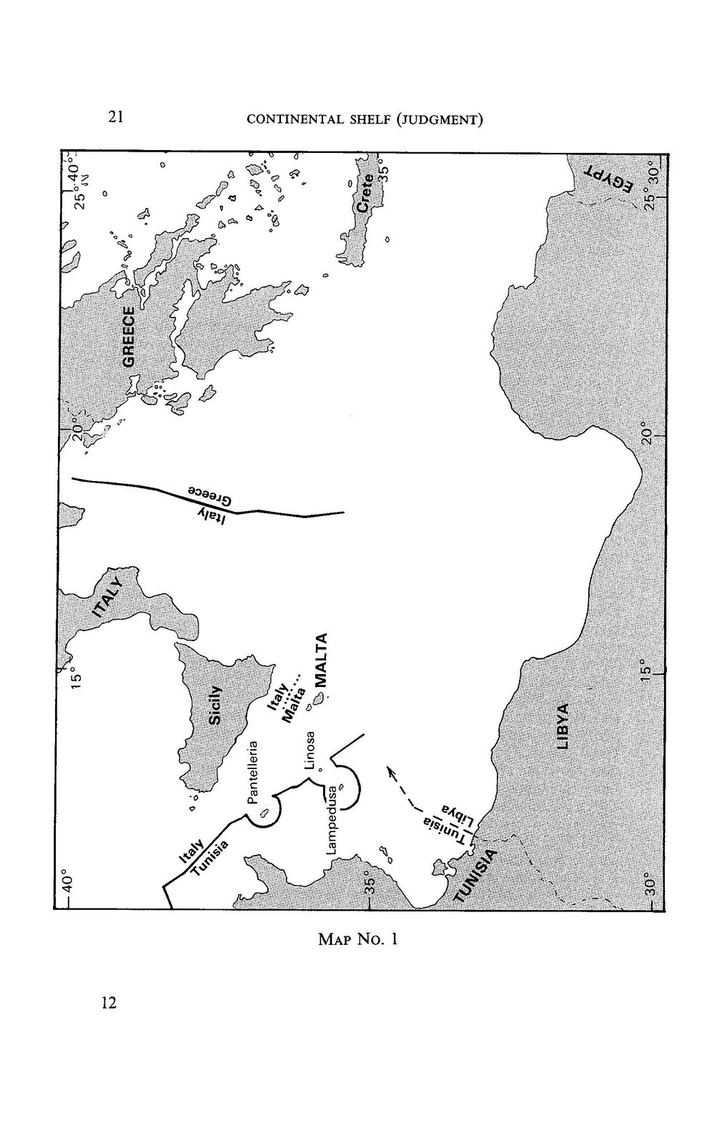
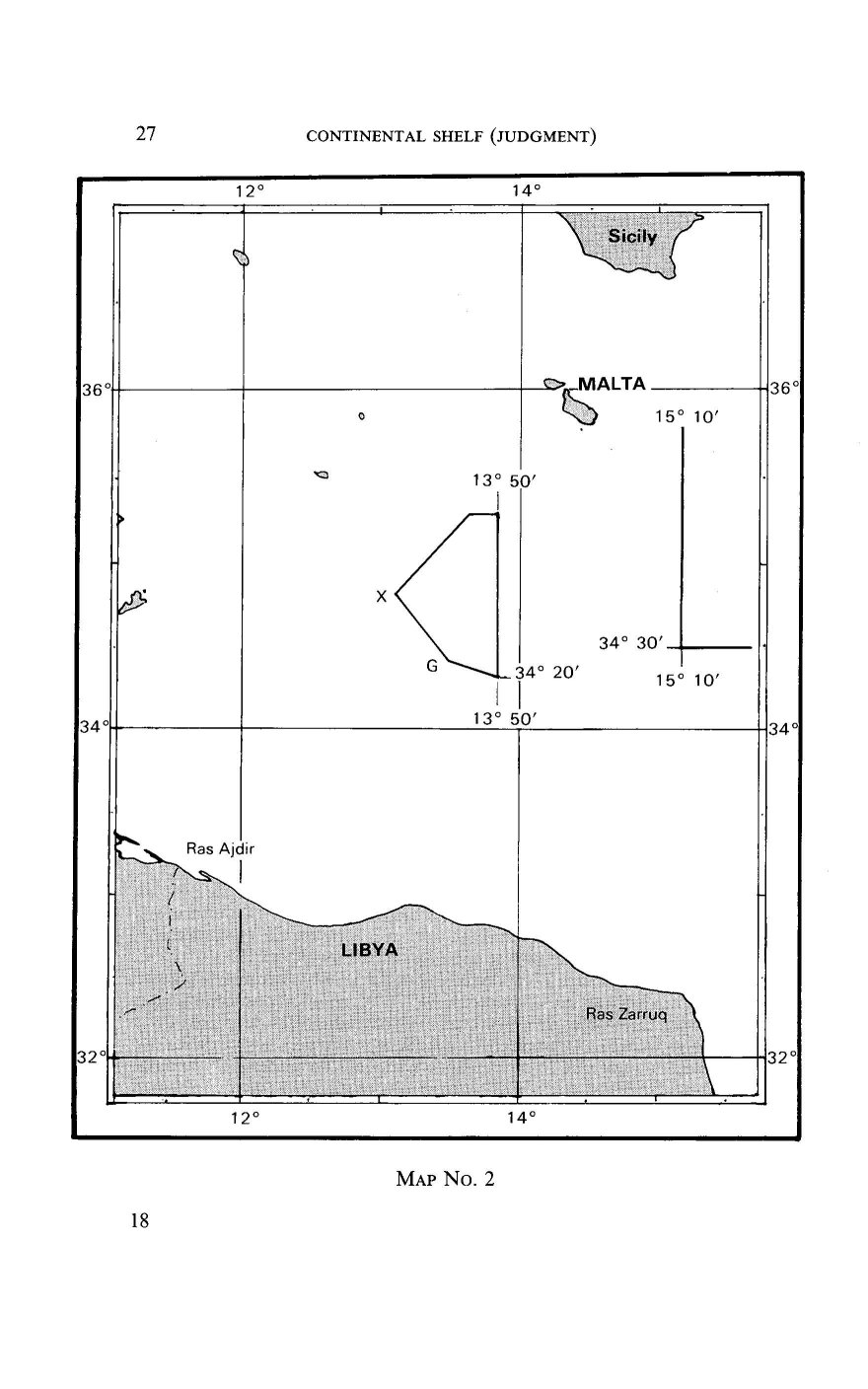