| |
[p90]
The Chamber of the International Court of Justice formed to deal with the
above-mentioned case,
composed as above,
after deliberation,
delivers the following Judgment:
1. By a joint letter of notification dated 11 April 2002, filed in the
Registry of the Court on 3 May 2002, the Republic of Benin (hereinafter
"Benin") and the [p95] Republic of Niger (hereinafter "Niger") transmitted
to the Registrar a certified copy of a Special Agreement, which was signed
on 15 June 2001 in Cotonou and entered into force on 11 April 2002. whereby
the Governments of the two States agreed to submit to a Chamber of the Court
a dispute concerning "the definitive delimitation of the whole boundary
between them".
2. The Special Agreement of 15 June 2001 provides as follows:
"The Government of the Republic of Benin and the Government of the Republic
of Niger, hereinafter the 'Parties';
Whereas, pursuant to the Agreement signed on 8 April 1994, having
provisionally entered into force on the date of its signing, having been
ratified by Benin on 17 July 1997 and by Niger on 1 February 2001, and
having definitively entered into force on 15 June 2001, the date on which
the instruments of ratification were exchanged, the two Governments created
the Joint Delimitation Commission for their boundary;
Whereas, notwithstanding six negotiating sessions held by that Commission,
the two States' experts have been unable to agree on the course of the joint
boundary;
Whereas, under Article 15 of that Agreement of 8 April 1994,
'the contracting Parties agree to submit all disputes or disagreements
arising out of the application or interpretation of this Agreement to
settlement through diplomatic channels or by the other means of peaceful
settlement provided for by the Charters of the Organization of African Unity
and the United Nations';
Desiring to achieve as rapidly as possible the settlement of the boundary
dispute between them on the basis of the provisions of the Charter and the
resolutions of the Organization of African Unity and to submit the question
of the definitive delimitation of the whole boundary between them to the
International Court of Justice, hereinafter the 'Court';
Have agreed as follows:
Article 1
Formation of a Chamber of the International Court of Justice
1. The Parties submit the dispute defined in Article 2 below to a chamber
of the Court, hereinafter the 'Chamber', formed in accordance with the
provisions of the Statute of the Court and the present Special Agreement.
2. Each of the Parties shall exercise the right granted it by Article 31,
paragraph 3, of the Statute of the Court to proceed to choose a judge ad
hoc.
Article 2
Subject of the Dispute The Court is requested to:
(a) determine the course of the boundary between the Republic of Benin and
the Republic of Niger in the River Niger sector;
(b) specify which State owns each of the islands in the said river, and in
particular Lete Island;
(c) determine the course of the boundary between the two States in the River
Mekrou sector. [p96]
Article 3
Written Proceedings
1. Without prejudice to any question as to the burden of proof, the Parties
request the Chamber to authorize the following procedure for the written
pleadings:
(a) a Memorial filed by each Party not later than nine (9) months after the
adoption by the Court of the Order constituting the Chamber;
(b) a Counter-Memorial filed by each Party not later than nine (9) months
after exchange of the Memorials;
(c) any other pleading whose filing, at the request of either of the
Parties, shall have been authorized or directed by the Court.
2. Pleadings submitted to the Registrar shall not be transmitted to the
other Party until the Registrar has received the corresponding pleading from
that Party,
Article 4
Oral Proceedings
The Parties shall agree, with approval from the Chamber, on the order in
which they are to be heard during the oral proceedings; if the Parties fail
to agree, the order shall be prescribed by the Chamber.
Article 5
Language of the Proceedings
The Parties agree that their written pleadings and their oral argument shall
be presented in the French language.
Article 6
Applicable Law
The rules and principles of international law applicable to the dispute are
those set out in Article 38, paragraph 1, of the Statute of the
International Court of Justice, including the principle of State succession
to the boundaries inherited from colonization, that is to say, the
intangibility of those boundaries.
Article 7
Judgment of the Chamber
1. The Parties accept the judgment of the Chamber given pursuant to the
present Special Agreement as final and binding upon them.
2. From the day on which the judgment is rendered, the Parties shall have
eighteen (18) months in which to commence the works of demarcation of the
boundary.
3. In case of difficulty in the implementation of the judgment, either Party
may seise the Court pursuant to Article 60 of its Statute.
Article 8
Entry into Force
The present Agreement is subject to ratification. It shall enter into force
on the date on which the instruments of ratification are exchanged, which
shall take place as rapidly as possible. [p97]
Article 9
Registration and Notification
The present Agreement shall be registered with the Secretariat of the United
Nations pursuant to Article 102 of the United Nations Charter by the more
diligent Party.
1. In accordance with Article 40 of the Statute of the Court, the present
Special Agreement shall be notified to the Registrar of the Court by a joint
letter from the Parties.
2. If such notification is not effected in accordance with the preceding
paragraph within one month from the entry into force of the present Special
Agreement, it shall be notified to the Registrar of the Court by the more
diligent Party.
Article 10
Special Undertaking
Pending the judgment of the Chamber, the Parties undertake to preserve
peace, security and quiet among the peoples of the two States.
In witness whereof, the present Special Agreement, drawn up in two original
copies, has been signed by the plenipotentiaries.
Done at Cotonou, 15 June 2001."
3. Pursuant to Article 40, paragraph 3, of the Statute of the Court and
Article 42 of the Rules of Court, the Registrar transmitted copies of the
joint letter of notification, of the Special Agreement and of the protocol
of exchange of the instruments of ratification to the Secretary-General of
the United Nations, the Members of the United Nations and other States
entitled to appear before the Court.
4. Article 1 of the Special Agreement provides for the submission of the
dispute to a Chamber to be formed in accordance with Article 26, paragraph
2, of the Statute, with a judge ad hoc to be chosen by each Party pursuant
to Article 31 of the Statute. The Parties, having been duly consulted by the
President of the Court regarding the composition of the Chamber, expressed
their wish, pursuant to Article 26, paragraph 2, of the Statute, and to
Article 17, paragraph 2, of the Rules of Court, for the formation of a
Chamber of five members, of whom two would be the judges ad hoc to be chosen
by them.
5. By a letter of 21 August 2002 the Deputy Agent of Benin informed the
Court that his Government had chosen Mr. Mohamed Bennouna to sit as judge ad
hoc. By a letter of 11 September 2002 the Agent of Niger informed the Court
that his Government had chosen Mr. Mohammed Bedjaoui to sit as judge ad hoc.
6. By an Order of 27 November 2002 the Court, acting pursuant to Article 26,
paragraph 2, of the Statute and Article 17 of the Rules of Court, decided to
accede to the request of the Parties that a special Chamber be formed to
deal with the case; it declared that, at an election held on 27 November
2002, President Guillaume and Judges Ranjeva and Kooijmans had been elected
to form, together with the above-named judges ad hoc, a Chamber to deal with
the case and that accordingly the said Chamber as so composed had been duly
constituted pursuant to that Order. In accordance with Article 18, paragraph
2, of the Rules of Court, Judge Guillaume, who held the office of President
of the Court when the Chamber was formed, was to preside over the Chamber.
[p98]
7. By the same Order, the Court, acting pursuant to Article 92, paragraph 1,
of the Rules of Court, fixed 27 August 2003 as the time-limit for the filing
of a Memorial by each Party and reserved the subsequent procedure for
further decision. The Memorials were duly filed within the time-limit thus
fixed.
8. By Order of 11 September 2003, the President of the Chamber, having
regard to Article 3, paragraph 1 (b), of the Special Agreement, fixed 28 May
2004 as the time-limit for the filing of a Counter-Memorial by each Party
and reserved the subsequent procedure for further decision.
9. The Chamber held a public sitting on 20 November 2003 to enable the
judges ad hoc to make the solemn declaration required by Article 31,
paragraph 6, of the Statute and by Article 8 of the Rules of Court.
10. On 28 May 2004, within the time-limit fixed by the Order of 11
September 2003, the Parties filed their respective Counter-Memorials in the
Registry. During a meeting held by the President of the Chamber with the
representatives of the Parties on 2 July 2004, in order to ascertain their
views on the subsequent procedure, the two Parties expressed the wish to be
authorized to submit a third pleading. By Order of 9 July 2004, the
President of the Chamber, having regard to Article 3, paragraph 1 (c), of
the Special Agreement, authorized the filing of a Reply by each Party and
fixed 17 December 2004 as the time-limit therefor, reserving the subsequent
procedure for further decision. The Parties filed their Replies in the
Registry within the time-limit thus fixed,
11. By a letter of 11 October 2004, Judge Guillaume, President of the
Chamber, informed the President of the Court, pursuant to Article 13,
paragraph 4, of the Statute, that he had decided to resign from the Court
with effect from 11 February 2005. Since his resignation would leave a
vacancy in the Chamber, the President of the Court consulted the Parties
again on 11 January 2005 regarding the composition of the Chamber. At an
election held on 16 February 2005, Judge Abraham was elected a member of the
Chamber to fill the seat left vacant by Judge Guillaume's resignation. By an
Order of 16 February 2005, the Court declared that, as a result of this
election, the Chamber was now composed as follows: Judge Ranjeva, who, in
his capacity as Vice-President of the Court, had become President of the
Chamber, pursuant to Article 18, paragraph 2, of the Rules of Court; Judges
Kooijmans and Abraham; and Judges ad hoc Bedjaoui and Bennouna.
12. By a letter of 11 February 2005, the Agent of Niger expressed his
Government's wish to produce two new documents pursuant to Article 56 of
the Rules of Court. By a letter of 25 February 2005, the Agent of Benin
informed the Chamber that his Government did not object to that production.
Following the decision of the Chamber to authorize the production of those
documents by Niger, the Registrar advised the Parties of that decision by
letters dated 2 March 2005.
13. Pursuant to Article 53, paragraphs, of the Rules of Court, the Chamber,
having ascertained the views of the Parties, decided to make accessible to
the public, with effect from the opening of the oral proceedings, copies of
the written pleadings and of the documents annexed thereto.
14. Public sittings were held on 7, 8, 10 and 11 March 2005, at which the
Chamber heard the oral arguments and replies of:
For Benin: H.E. Mr. Rogatien Biaou,
Mr. Alain Pellet,
Maitre Robert Dossou, [p99]
Mr. Mathias Forteau,
Mr. Jean-Marc Thouvenin.
For Niger: H.E. Ms Aïchatou Mindaoudou,
Mr. Jean Salmon,
Mr. Amadou Tankoano,
Mr. Gerard Niyungeko,
Mr. Pierre Klein.
At the hearings questions were put by the Chamber, to which replies were
given in writing pursuant to Article 61, paragraph 4, of the Rules of Court.
Each Party submitted its written comments on the other's written replies in
accordance with Article 72 of the Rules of Court.
*
15. In the course of the written proceedings, the following submissions were
presented by the Parties:
On behalf of the Government of Benin,
in the Memorial:
"Having regard to all of the foregoing considerations, the Republic of Benin
requests the Chamber of the International Court of Justice to decide:
(1) that the boundary between the Republic of Benin and the Republic of
Niger takes the following course:
— from the point having co-ordinates 11° 54' 15" latitude North and 2° 25'
10" longitude East, it follows the median line of the River Mekrou as far as
its point of confluence with the River Niger,
— from that point, the boundary continues as far as the left bank of the
River [Niger], which it follows until it reaches the boundary of Nigeria, as
defined by the Franco-British Agreements of 29 May and 19 October 1906;
(2) that sovereignty over all of the islands in the River [Niger], and in
particular the island of Léte, lies with the Republic of Benin."
in the Counter-Memorial:
"For the reasons set out in its Memorial and in the present
Counter-Memorial, the Republic of Benin maintains its submissions and
requests the Chamber of the International Court of Justice to decide:
(1) that the boundary between the Republic of Benin and the Republic of
Niger takes the following course:
— from the point having co-ordinates 11° 54' 15" latitude North and 2"
25'10" longitude East, it follows the median line of the River Mekrou as far
as the point having co-ordinates 12° 24'29" latitude North and 2° 49'38"
longitude East,
— from that point, the boundary follows the left bank of the River [Niger]
as far as the point having co-ordinates 11° 41'44" North and 3°36'44" East;
(2) that sovereignty over all of the islands in the River [Niger], and in
particular the island of Lété, lies with the Republic of Benin."
[p100]
in the Reply :
"For the reasons set out in its Memorial and in its Counter-Memorial, as
well as in the present Reply, the Republic of Benin maintains its
submissions and requests the Chamber of the International Court of Justice
to decide:
(1) that the boundary between the Republic of Benin and the Republic of
Niger takes the following course:
— from the point having co-ordinates 11° 54' 15" latitude North and 2° 25'
10" longitude East, it follows the median line of the River Mekrou as far as
the point having co-ordinates 12° 24'29" latitude North and 2° 49'38"
longitude East,
— from that point, the boundary follows the left bank of the River [Niger]
as far as the point having co-ordinates 11°41’44" North and 3°36'44" East;
(2) that sovereignty over all of the islands in the River [Niger], and in
particular the island of Lété, lies with the Republic of Benin."
On behalf of the Government of Niger,
in the Memorial:
"The Republic of Niger requests the Court to adjudge and declare that:
— the boundary between the Republic of Benin and the Republic of Niger in
the River Niger sector, from the confluence of the River Mekrou with the
River Niger as far as the boundary of Nigeria, follows the line of deepest
soundings, on the understanding that, in the event of a future change in the
course of that line, the boundary between the Republic of Benin and the
Republic of Niger will follow that new course;
— the current line of deepest soundings in this part of the river
determines which islands belong to each Party;
— the islands located between the line of deepest soundings and the right
bank of the river, namely Tondi Kwaria Barou, Koki Barou, Sand ł Tounga
Barou, Gandégabi Barou Kaïna, Dan Koré Guirawa, Barou Elhadji Dan Djoda,
Koundou Barou, Elhadji Chaïbou Barou Kaïna and Dole Barou, belong to the
Republic of Benin;
— the islands located between the line of deepest soundings and the left
bank of the river, namely Boumba Barou Bed, Boumba Barou Kaïna, Kouassi
Barou, Sansan Goungou, Lété Goungou, Monboye Tounga Barou, Sim Goungou, Lama
Barou, Koten a Barou, Gagno Goungou, Kata Goungou, Gandégabi Barou Béri,
Guirawa Barou, Elhadji Chaïbou Barou Béri, Goussou Barou and Beyî Barou,
belong to the Republic of Niger;
— the attribution of islands to the Republic of Benin and the Republic of
Niger shall be regarded as final, even in the event of a future change in
the course of the line of deepest soundings;
— the boundary between the Republic of Benin and the Republic of Niger in
the River Mekrou sector follows a line comprising two parts:
— the first part is a straight line joining the point of confluence of the
River Mekrou with the River Niger to the point where the Paris meridian
meets the Atacora mountain range, indicative co-ordi-[p101]nates of which
are as follows: latitude: 11°41'50" North; longi-tude: 2°20'14"East;
— the second part of the line joins this latter point to the point where the
former boundary between the cercles of Say and Fada meets the former
boundary between the cerdes of Fada and Atacora, indicative co-ordinates of
which are as follows; latitude: 11°44'37" North; longitude: 2° 18'55" East."
in the Coun ter-Memorial:
"The Republic of Niger requests the Court to adjudge and declare that:
— the boundary between the Republic of Benin and the Republic of Niger in
the River Niger sector, from the confluence of the River Mekrou with the
River Niger as far as the boundary of Nigeria, follows the line of deepest
soundings, on the understanding that, in the event of a future change in the
course of that line, the boundary between the Republic of Benin and the
Republic of Niger will follow that new course;
— the current course of the line of deepest soundings in this part of the
river determines which islands belong to each Party;
— the islands located between the line of deepest soundings and the right
bank of the river, namely Tondi Kwaria Barou, Koki Barou, Sandi Tounga
Barou, Gandégabi Barou Kama, Dan Koré Guirawa, Barou Elhadji Dan Djoda,
Koundou Barou, Elhadji Chaïbou Baron Kaïna and Dole Barou, belong to the
Republic of Benin;
— the islands located between the line of deepest soundings and the left
bank of the river, namely Boumba Barou Béri, Boumba Barou Kama, Kouassi
Barou, Sansan Goungou, Lété Goungou, Monboye Tounga Barou, Sini Goungou,
Lama Barou, Kotcha Barou, Gagno Goungou, Kata Goungou, Gandégabi Barou Béri,
Guirawa Barou, Elhadji Chaïbou Barou Béri, Goussou Barou and Beyo Barou,
belong to the Republic of Niger;
— the attribution of islands to the Republic of Benin and the Republic of
Niger shall be regarded as final, even in the event of a future change in
the course of the line of deepest soundings;
— the boundary between the Republic of Benin and the Republic of Niger in
the River Mekrou sector follows a line comprising two parts:
— the first part is a straight line joining the point of confluence of the
River Mekrou with the River Niger to the point where the Paris meridian
meets the Atacora mountain range, indicative co-ordinates of which are as
follows: latitude: 11°41 '50" North; longitude: 2°20'14" East;
— the second part of the line joins this, latter point to the point where
the former boundary between the cerdes of Say and Fada meets the former
boundary between the cerdes of Fada and Atacora, indicative co-ordinates of
which are as follows: latitude; 11°44'37" North; longitude: 2° 18'55" East."
in the Reply :
"The Republic of Niger requests the Court to adjudge and declare that;
— the boundary between the Republic of Benin and the Republic of Niger in
the River Niger sector, from the confluence of the River [p102] Mekrou with
the River Niger as far as the boundary of Nigeria, follows the line of
deepest soundings, in so far as that line can be established as it was at
the date of independence;
— that line determines which islands belong to each Party;
— the islands between the line of deepest soundings and the right bank of
the river, namely Pekinga, Tondi Kwaria Barou. Koki Barou. Sandi Tounga
Barou, Gandegabi Barou Kama, Dan Kore Guirawa, Barou Elhadji Dan Djoda,
Koundou Barou and Elhadji Chaibou Barou Kama, belong to the Republic of
Benin;
— the islands located between the line of deepest soundings and the left
bank of the river, namely Boumba Barou Beri, Boutnba Barou Kama, Kouassi
Barou, Sansan Goungou, Lete Goungou, Monboye Tounga Barou, Sini Goungou,
Lama Barou, Kotcha Barou, Gagno Goungou, Kata Goungou, Gandegabi Barou Beri,
Guirawa Barou, Elhadji Chaibou Barou Bed, Goussou Barou, Beyo Barou and Dole
Barou, belong to the Republic of Niger,
— the attribution of islands to the Republic of Benin and the Republic of
Niger according to the line of deepest soundings as determined at the date
of independence shall be regarded as final. It shall be for the Parties to
ensure that this channel remains the principal navigable channel by carrying
out dredging works as necessary;
— the boundary between the Republic of Benin and the Republic of Niger in
the River Mekrou sector follows a line comprising two parts:
— the first part is a straight line joining the point of confluence of the
River Mekrou with the River Niger to the point where the Paris meridian
meets the Atacora mountain range, indicative co-ordinates of which are as
follows: latitude: 11°41'50" North; longitude: 2°20'14"East;
— the second part of the line joins this latter point to the point where the
former boundary between the cercles of Say and Fada meets the former
boundary between the cercies of Fada and Atacora, indicative co-ordinates of
which are as follows; latitude: 11° 44'37" North, longitude: 2° 18'55"
East."
16. At the oral proceedings, the following submissions were presented by the
Parties:
On behalf of the Government of Benin,
"For the reasons set out in its written and oral pleadings, the Republic of
Benin requests the Chamber of the International Court of Justice to decide:
(1) that the boundary between the Republic of Benin and the Republic of
Niger takes the following course:
— from the point having co-ordinates 11° 54' 15" latitude North and 2° 25'
10" longitude East, it follows the median line of the River Mekrou as far as
the point having co-ordinates 12° 24'29" latitude North and 2° 49'38"
longitude East,
— from that point, the boundary follows the left bank of the River [Niger]
as far as the point having co-ordinates 11° 41'44" North and 3°36'44"East;[p103]
(2) that sovereignty over all of the islands in the River [Niger], and in
particular the island of Lété, lies with the Republic of Benin."
On behalf of the Government of Niger,
"The Republic of Niger requests the Court to adjudge and declare that:
(1) The boundary between the Republic of Benin and the Republic of Niger
follows the line of deepest soundings in the River Niger, in so far as that
line could be established at the date of independence, from the point having
co-ordinates latitude 12° 24'27" North, longitude 2° 49' 36" East, as far as
the point having co-ordinates latitude 11° 41' 40.7" North, longitude
3°36'44" East.
(2) That line determines which islands belong to each Party.
— The islands between the line of deepest soundings and the right bank of
the river, namely Pekinga, Tondi Kwaria Barou, Koki Barou, Sandi Tounga
Barou, Gandégabi Barou Kaïna, Dan Koré Guirawa, Barou Elhadji Dan Djoda,
Round ou Barou and Elhadji Cha'ibou Barou Kaïna, belong to the Republic of
Benin.
— The islands located between the line of deepest soundings and the left
bank of the river, namely Boutnba Barou Béri, Boumba Barou Kaïna, Kouassi
Barou, Sansan Goungou, Lété Goungou, Mon-boye Tounga Barou, Sini Goungou,
Lama Barou, Kotcha Barou, Gagno Goungou, Rata Goungou, Gandégabi Barou Béri,
Guirawa Barou, Elhadji Chaïbou Barou Béri, Gîussou Barou, Beyî Barou and
Dole Barou, belong to the Republic of Niger.
(3) The attribution of islands to the Republic of Benin and the Republic of
Niger according to the line of deepest soundings as determined at the date
of independence shall be regarded as final.
(4) With regard to the Gaya-Malanville bridges, the boundary passes through
the middle of each of those structures.
(5) The boundary between the Republic of Benin and the Republic of Niger in
the River Mekrou sector follows a line comprising two parts:
— the first part is a straight line joining the point of confluence of the ,
River Mekrou with the River Niger to the point where the Paris meridian
meets the Atacora mountain range, indicative co-ordinates of which are as
follows: latitude: 11° 41'50" North; longitude: 2°20'14" East;
—the second part of the line joins this latter point to the point where the
former boundary between the cercles of Say and Fad a meets the former
boundary between the cercles of Fad a and Atacora, indicative co-ordinates
of which are as follows: latitude: 11°44'37" North; longitude: 2° 18'55"
East."
***
17. The task assigned to the Chamber in the present case by the Special
Agreement of 15 June 2001 is to determine the course of the whole boundary
between Benin and Niger and to specify to which State each of the islands in
the River Niger sector belongs, and in particular the island of Lété.
[p104]
Benin and Niger are Stales in western Africa. The Republic of Benin,
formerly known as the Republic of Dahomey (from 1960 to 1975) then as the
People's Republic of Benin (from 1975 to 1990), covers an area of 112,622 sq
km; it is bounded to the south by the Atlantic Ocean, to the west by Togo,
to the north-west by Burkina Faso, to the north by Niger and to the east by
Nigeria, The Republic of Niger, with an area of 1,267,000 sq km, is bounded
to the south by Nigeria, to the south-west by Benin, to the west by Burkina
Faso, to the north-west by Mali, to the north by Libya and Algeria, and to
the east by Chad. Sketch-map No. 1, on page 105 below, illustrates the
general situation of the territories of the Parties,
18. Article 2 of the Special Agreement divides the disputed boundary into
two sectors: the River Mekrou sector in the west and the River Niger sector
in the east. Sketch-map No. 2, on page 106 below, gives a general view of
this boundary.
The western part of this boundary follows a course running approximately
south-west to north-east, passing through woodland composed of transitional
Sudano-Sahelian vegetation, from a point marking the boundary between the
two States and Burkina Faso as far as the confluence of the River Mekrou
and the River Niger.
The eastern part of the boundary follows the River Niger in a southeasterly
direction over a distance of some 150 km from that confluence and ends at a
point marking the boundary of the two States with Nigeria, The Parties have
submitted differing descriptions of the characteristics of the River Niger
in the region. According to Benin, the river is subject to siltation, which
has led to a change in its course over time particularly affecting the right
bank, which is much less stable than the left bank. Although it acknowledges
the existence of this phenomenon, Niger maintains that, because of the
nature of the rocks in the stretch of river concerned, there has been no
significant change in the course of The main channel for more than a
century* and that there is no substantial difference in the configuration
of each bank. In this sector, three tributaries (the Mekrou, the Alibori and
the Sola) enter the River Niger from the right bank, as a result of which it
floods twice a year, in January-March and. in September-October. The Parties
have conflicting views as to whether, in the area subject to delimitation,
the river is navigable during the low-water season: Benin claims that it is
not but Niger maintains that navigation is possible throughout the year for
certain types of craft.
19. There are several islands within the stretch concerned; their exact
number and. their attribution to either Party are matters of dispute in the
present case.
The island of Lete, referred to expressly in Article 2 (h) of the Special
Agreement, is the largest, covering approximately 40 sq km. It extends
16,300 m from a point opposite the villages of Kwara Tegui (Benin) and Ouna
(Niger) to a point opposite the villages of Karimama (Benin) and Albarkaize
(Niger). The approximate co-ordinates of the extremities of
[p105]
Sketch-Map No. 1. General
Situation of the Parties' Territories
[p106]
Sketch-Map No. 2. General View
of the Boundary Region Between the Parties.
[p107]
the island are: upstream, 12°9'55" latitude North and 3°6'47" longitude
East; downstream, 12° 3'43" latitude North and 3° 13' 39" longitude East.
The island is fertile, with rich pastures, and is permanently inhabited;
according to information supplied by Niger, its population numbered some
2,000 in the year 2000.
**
20. The frontier dispute between the Parties is set within a historical
context marked by the accession to independence of the territories that were
formerly part of French West Africa ("Afrique occidentale française",
hereinafter "AOF"). Benin, which has been independent since 1 August 1960,
corresponds to the former colony of Dahomey, and Niger, which has been
independent since 3 August 1960, corresponds to a territory which underwent
various administrative transformations during the colonial period.
21. In their written pleadings, both Parties referred to incidents that
occurred on the island of Lé té on the eve of their independence, in 1959
and 1960. Following those events, the two States set up a process for the
friendly settlement of their frontier dispute: in 1961 and 1963 two
Daho-mey-Niger joint commissions met to discuss the matter.
In October 1963 the crisis between Dahomey and Niger deepened, in particular
regarding the island of Lété. Each State subsequently published a White
Paper setting out, inter alia, their respective positions regarding the
frontier dispute.
There were fresh attempts to reach a peaceful settlement in the years that
followed, culminating in a conference held in Yamoussoukro on 18 January
1965, in the course of which the Parties agreed "until the dispute over the
island is finally settled, to allow nationals of both countries to live in
perfect harmony on that island". However, the issue of sovereignty over the
island of Lété was not resolved and there were further incidents in
subsequent years, notably in 1993 and 1998.
22. On 8 April 1994 Benin and Niger entered into an agreement creating a
joint commission for the delimitation of their common border, whose terms of
reference included the enumeration, collection and analysis of documents
relating to the frontier and the precise establishment thereof. The
commission held six meetings between September 1995 and June 2000.
Since efforts to arrive at a negotiated solution to the dispute were
unsuccessful, the commission proposed that the Governments of the two States
bring the dispute before the International Court of Justice by Special
Agreement. The Special Agreement was signed in Cotonou on 15 June 2001 and
entered into force on 11 April 2002.
**
23. Under Article 6 of the Special Agreement ("Applicable Law"), the rules
and principles of international law applicable to the present dispute
include "the principle of State succession to the boundaries inherited from
colonization, that is to say, the intangibility of those boundaries". It
follows from the wording of this provision and from the arguments of the
Parties that they are in agreement on the relevance of the principle of uti
possidetis juris for the purposes of determining their common border. As the
Chamber formed in the case concerning the frontier Dispute (Burkina
Faso/Republic of Mali) had occasion to state, the existence of this
principle has been recognized on several occasions in the African context
(Frontier Dispute (Burkina Faso/Republic of Mali), Judgment, T.C.J. Reports
1986, p. 565, para. 20); it was recognized again recently, in Article 4 (b)
of the Constitutive Act of the African Union, of which Benin and Niger are
members, signed in Lomé on 11 July 2000, That Chamber stated that, according
to the principle in question, "pre-eminence [is] accorded to legal title
over effective possession as a basis of sovereignty'' and that its essence
lies "in its primary aim of securing respect for the territorial boundaries
at the moment when independence is achieved", including former
administrative delimitations established during the colonial period that
became international frontiers (I.C.J. Reports 1986, pp. 586-587, para. 63,
and p. 566, para. 23).
24. On the basis of the principle of uti possidetis juris, the present
Chamber must thus seek to determine, in the case before it, the boundary
that was inherited from the French administration. The Parties agree that
the dates to be taken into account for this purpose are those of their
respective independence, namely 1 and 3 August 1960; the Chamber would
observe that there was no change in the frontier between these two very
close dates.
25. The Parties have nonetheless sometimes expressed differing opinions
regarding certain aspects of the application of the uti possidetis juris
principle in the present case.
Firstly, Niger maintains that this principle does not preclude the Chamber
from taking account, where appropriate, of the physical realities
subsequent to independence, in order to ensure that the Judgment will have
meaningful and practical significance between the Parties. Consequently, in
requesting the Chamber to indicate to which State each of the islands in the
River Niger belongs, by reference to the line of deepest soundings at the
date of independence. Niger asks it to consider for this purpose only those
islands that exist at the present time.
Benin, for its part, argues that, if the uti possidetis juris principle is
to be applied strictly, it would be unacceptable to refer to the present
situation in order to determine to which Party the islands belonged at the
date of independence.
The Chamber observes that, in any event, the Parties agree that the course
of their common boundary should be determined, in accordance with the uii
possidetis juris principle, by reference to the physical situa-[p109]tion
to which French colonial law was applied, as that situation existed at the
dates of independence. However, the consequences of such a course on the
ground, particularly with regard to the question of to which Party the
islands in the River Niger belong, must be assessed in relation to
present-day physical realities and, in carrying out the task assigned to it
under Article 2 of the Special Agreement, the Chamber cannot disregard the
possible appearance or disappearance of certain islands in the stretch
concerned.
26. Secondly, Benin and Niger have put forward differing views with respect
to the documents or maps on which the Chamber should base its determination
of their common boundary.
In support of its delimitation claims, Niger relies on certain documents and
maps that are posterior to the dates of independence, not only to
demonstrate current physical realities but also to establish the situation
existing in the colonial era. According to Niger, that situation must be
determined on the basis of the studies conducted closest in time to the
Parties' accession to independence, without being confined to those
conducted prior to the dates of independence.
Benin considers, to the contrary, that the Chamber should base its decision
on research and documents prior to the critical date.
The Chamber cannot exclude a priori the possibility that maps, research or
other documents subsequent to that date may be relevant in order to
establish, in application of the uti possidetis juris principle, the
situation that existed at the time. In any event, since the effect of the
uti possidetis principle is to freeze the territorial title (Frontier
Dispute (Burkina Faso/Republic of Mali), Judgment, I.C.J. Reports 1986, p.
568, para. 29), the examination of documents posterior to independence
cannot lead to any modification of the "photograph of the territory" at the
critical date unless, of course, such documents clearly express the
Parties'' agreement to such a change.
27. Thirdly, the Parties have discussed the legal value, in the light of the
uti, possidetis juris principle, of post-colonial effect ivites.
The Chamber notes that both Parties have on occasion sought to confirm the
legal title which they claim by relying on acts whereby their authorities
allegedly exercised sovereignty over the disputed territories after 1960;
such effeclivites have been invoked by Niger inter alia in respect of
activities relating to the River Niger and its islands, and by Benin in
respect of activities relating to the right bank of the River Mekrou.
Such an approach should not necessarily be excluded. As stated by the
Chamber formed in the case concerning the Land, Island and Maritime Frontier
Dispute (El Salvador/Honduras: Nicaragua intervening), it is possible to
"have regard ... in certain instances, to documentary evidence of
post-independence effect ivites when . . . they afford indications in [p110] respect of the . . . uti possidetis juris boundary, providing a
relationship exists between the effectivites concerned and the
determination of that boundary" (Judgment, I.C.J. Reports 1992, p. 399,
para, 62).
*
28. The Parties both acknowledge that, in accordance with the principle of
uti possidetis juris, the course of the frontier and the attribution of
islands in the River Niger to either one of them must be determined in the
light of French colonial law, known as "droit d'outre-mer". They also agree
on the identification of the relevant rules of that law, but do not share
the same interpretation thereof.
Before turning to those rules, the Chamber would recall that, when
reference is made to domestic Jaw in such a context, that law is applicable
"not in itself (as if there were a sort of continuum juris, a legal relay
between such law and international law), but only as one factual element
among others, or as evidence indicative of . . . the 'colonial heritage' "
(Frontier Dispute (Burkina Faso/Republic of Mali), Judgment, I.C.J. Reports
1986, p. 568, para. 30).
29. As the Chamber in the case concerning the Frontier Dispute (Burkina
Faso/Republic of Mali) (I.C.J. Reports 1986, pp. 568-569, para, 31) already
observed, the territorial administration of the French possessions in West
Africa was centralized by a decree of the President of the French Republic
of 16 June 1895 and placed under the authority of a Governor-General. The
entity of the AOF thus created was divided into colonies, headed by
Lieutenant-Governors and themselves made up of basic units called "cercles”
which were administered by commandants de terete; each cercle was in turn
composed of subdivisions, each administered by a chef de subdivision. The
subdivisions consisted of cantons, which grouped, together a number of
villages.
30. The Parties acknowledge that the creation and abolition of colonies
fell within the jurisdiction of the authorities of metropolitan France: the
President of the French Republic, acting by decree, under the Constitution
of the Third Republic, and subsequently the French Parliament, following the
adoption of the Constitution of 27 October 1946.
The power to create territorial subdivisions within a single colony, on the
other hand, was vested in the AOF until being transferred to the local
representative institutions in 1957.
Article 5 of the decree of the President of the French Republic, dated 18
October 1904, providing for the reorganization of the AOF, vested the
Governor-General with authority to "determine in government council (conseil
de gouvernement), and on the proposal of the Lieutenant-Governors
concerned, the administrative districts in each of the colonies".
In his circular No. 114c of 3 November 1912, concerning the form of [p111]
instruments for the organization of administrative districts and
subdivisions, the Governor-General interpreted this text as conferring upon
him "the right to establish . . , the number and extent of the cercles
which, within the colonies, constitute[d] the actual administrative unit",
but pointed out that it was "acknowledged that the Lieutenant-Governors
would retain the power to determine the territorial subdivisions created
within these cercles by measures adopted under their own authority".
According to that circular, "any measure concerning the administrative
district, the territorial unit proper, i.e. affecting the cercle, in terms
of its existence (creation or abolition), its extent, its name, or the
location of its administrative centre", was to be confirmed by an arrêté
général adopted in government council; it lay with the Lieutenant-Governors
"to define, by means of arrêtés, the approval of which [was] reserved to
[the Governor-General], the exact and detailed topographical boundaries of
each of these districts", as well as "within the cercles, [to] fix . , . the
number and extent of The territorial subdivisions . . . and the location of
their centre" by means of local decisions.
31. Benin submits that, in the light of these texts, the rules applicable to
the creation of colonies and their subdivisions should be distinguished from
those relating to the establishment of territorial boundaries. At the
hearings, Benin nevertheless acknowledged that the principle whereby
authorities empowered to create colonies or administrative districts were
also competent to define or modify the boundaries thereof was certainly
applicable to colonies. However, Benin contended that such competence was
not exclusive and that in all likelihood the said principle did not apply in
respect of the internal boundaries within colonies. In any event, the local
authorities, headed by the Lieutenant-Governors, had authority, by virtue
of the rules governing the fixing of territorial boundaries, to clarify
central authorities'' decisions.
Niger, on the other hand, contends that the power to create colonies, as
conferred by the above-mentioned texts, entailed the implicit power to
establish their overall extent, from which boundaries of varying precision
could be determined on a case-by-case basis. According to Niger, it
followed from this that the rules concerning the creation and organization
of colonial administrative districts gave implicit prerogatives to the
French metropolitan authorities for the determination of in ter-territorial
boundaries, and to the authorities of the AOF for the delimitation of
administrative districts and their subdivisions. The Lieutenant-Governors'
competence in this matter was confined to certain specific circumstances,
according to a procedure and formalities laid down by the above-mentioned
texts.
**
32. For a better understanding of the historical context in which the
Parties' claims stand in relation to the determination of the frontier and
[p112] to the question of to whom the islands in the River Niger belong,
the evolution of the legal status of the territories concerned during the
colonial period should be briefly recapitulated.
33. In the second half of the nineteenth century, France initially
established settlements along the coast of Dahomey, at Cotonou and Porto
Novo. Following an armed conflict with the local chieftain in the 1880s and
1890s, it consolidated its presence in the region first by placing Dahomey
under protectorate (1892), and then by creating the "colony of Dahomey and
dependencies" (decree of 22 June 1894). France subsequently launched
expeditions northwards from its possessions in Dahomey, as well as
southwards and eastwards from Sudan, which enabled it, in the autumn of
1897, to occupy the valley of the River Niger (in particular the sector
between Say and Boussa).
The French occupation was expressly formalized, as regards the region of
north-western Dahomey, by a convention concluded with Germany on 23 July
1897, and as regards north-eastern Dahomey, by a convention concluded with
Great Britain on 14 June 1898. By means of a convention of 8 April 1904,
certain adjustments were made to the line established in 1898 in order to
separate the French and British areas of influence. The parties to that
convention fixed the boundaries of their respective possessions in
accordance with those adjustments by means of a convention of 29 May 1906 in
respect of the region to the east of the River Niger, and by means of an
agreement of 19 October 1906 in respect of the territories between the Gulf
of Guinea and that river; demarcation operations, documented in an official
record dated 19 February 1910, were subsequently carried out by the
Anglo-French Commission for the delimitation of the territories situated
between the Niger and Lake Chad.
34. At the end of the nineteenth century, when the colony of Dahomey was
incorporated into the AOF by decree of 17 October 1899, it encompassed, in
the region concerned by the present dispute, territories situated on both
banks of the River Niger. By virtue of the same decree, which had provided
for the dissolution of French Sudan and the apportionment of the territories
it had comprised among different colonies and two specially created
military territories, (he territory of Say was also attributed to Dahomey.
This territorial incorporation was put into effect by an arrêté of the
Governor of Dahomey dated 20 March 1901.
By arrêté of 23 July 1900, the Governor-General of the AOF decided to
establish a third military territory encompassing the regions on the left
bank of the River Niger from Say to Lake Chad. That 1900 arrêté was followed
by a decree of the President of the French Republic dated 20 December 1900
with the same object. The boundary between the Third Military Territory and
the First Military Territory created in 1899 was subsequently determined by
an arrêté of the Governor-General of the AOF, dated 20 March 1902.
By a decree of 18 October 1904 on the reorganization of the General
Government of the AOF, the President: of the French Republic inter alia
established the colony of Haut-Sénégal et Niger comprising "the former
[p113] territories of Haut-Sénégal and Moyen-Niger and those which form[ed]
the Third Military Territory". The newly created colony was composed of
"cercles under civil administration" as well as the "Military Territory of
Niger", constituted by the former First and Third Military Territories.
By decree of 2 March 1907, the cercles of Fada-N'Gourma and Say were
detached from Dahomey and incorporated into the colony of Haut-Sénégal et
Niger. The intercolonial boundary fixed by that decree was revised on two
occasions in its western part, first by a decree of 12 August 1909, and
subsequently by a decree of 23 April 1913.
35. On 7 September 191.1, a further decree separated the Military Territory
of Niger from the colony of Haut-Sénégal et Niger (the cercle of Say
remaining as a district of that colony), in order to make it an
administrative subdivision under the direct control of the office of The
Govern-ment-General of the AOF. On 1 January 1921, that military territory
became the Civil Territory of Niger, and was then made an autonomous colony
by decree of 13 October 1922.
In the meantime, the decree of 1 March 1919 had provided for the
establishment of the colony of Haute-Volta, to which were attributed, inter
alia, the cercles of Say and Fada-N'Gourma, which had hitherto formed part
of Haut-Sénégal et Niger,
By decree of 28 December 1926, certain cantons in the cercle of Dori and the
cercle of Say (with the exception of the canton of Gourmanché-de-Botou) were
detached from Haute-Volta and incorporated into Niger. An arrêté general of
31 August 1927 and the erratum thereto of 5 October of the same year
determined the boundary between the colonies of Haute-Volta and Niger.
The colony of Haute-Volta was abolished by decree of 5 September 1932, then
reconstituted with the same territorial basis by Law No. 47-1707 of 4
September 1947; in the intervening period, the cercles of Fada and Dori
(excluding the canton of Aribinda) were incorporated into Niger.
36. During the colonial period, the administrative organization of Dahomey
and Niger wag the subject of several successive enactments.
Following its establishment in 1894, the colony of Dahomey and dependencies
was organized by arrêté of the Governor ad interim, dated 11 August 1898;
that arrêté established four cercles in the colony, including that of
Moyen-Niger, which comprised inter alia "the territories of Zaberma or Dendi
situated on either side of the Niger and their dependencies" and that of
Gourma, which comprised "the provinces of Fada N'Gourma, Parna, Matiacouali,
Kodjar, Botou and their dependencies". The territorial divisions of the
colony were reorganized by arrêtés of the Governor-Genera] of the AOF, dated
8 December 1934 and 27 October 1938; those two arrêtés inter alia defined
the boundaries of the cercles of Kandi and of Natitingou, adjoining the
colony of Niger.
The internal reorganization of Niger was the subject of successive arrêtés
of the Govern or-General of the AOF, dated 26 December 1904, [p114] 31
December 1907, 14 December 1908, 22 June 1910, 23 November 1912 aud 22
January 1927. On the eve of independence, as a result of an arrêté général
of 30 March 1956 adding seven new cercles to the colony, Niger comprised 16
cercles.
**
37. The Chamber will now describe the main documents relevant to the
settlement of the frontier dispute. In this connection, a distinction should
be made between those documents that concern the determination of the course
of the boundary in the River Niger sector and the question of to whom the
islands in that river belong and those documents that relate to the
delimitation in the River Mekrou sector.
38. As regards the sector of the River Niger and the islands therein, the
essential documents, in chronological order, are as follows:
— the arrêté general of 23 July 1900 creating a Third Military Territory,
the administrative centre of which was established at Zînder. Article 1 of
this arrêté stated that this territory "encompass[ed] the areas on the left
bank of the Niger between Say and Lake Chad that [had been] placed within
the French sphere of influence by the Convention of 14 June 1898";
— the decree of 20 December 1900 creating a Third Military Territory between
the Niger and Lake Chad;
— letter No. 163 from the Minister for the Colonies, dated 7 September 1901,
addressed to the Governor-General of the AOF. In this letter, the Minister
referred to a previous communication, by which the Govern or-General had
transmitted two reports to him from the Governor of Dahomey "regarding the
question of the delimitation between Dahomey and the Third Military
Territory, and indicating the course of the Niger as the best demarcation
line, both from a geographical and political perspective". In response to
the Governor-G encrai' s view that this proposal seemed "highly acceptable",
the Minister indicated in his letter that "on this point, he share[d] [the]
view" of the Govern or-General;
— letter No. 54 of 3 July 1914, under cover of which administrateur adjoint
Sadoux, commandant of the secteur of Gaya (Niger), sent to the commandant of
the cercle of Moyen-Niger (Dahomey) "a table of the islands in the River
Niger indicating the major branch of the river and îhe colony to which the
islands therefore belonged]", which he had prepared "for the sole purpose of
clearly determining when grazing permits [should] be issued to the Petihls
from both banks and delimiting the territorial jurisdiction of the
indigenous tribunals in the two colonies". In his letter, the administrateur
adjoint indicated that he "believe[d] . . . that it [was] the main channel
that [should] serve as delimitation" between the territories concerned, "the
commandant of the secteur of Guéné having cited to [him the previous year] a
text on [p115] this subject, which [was] in Kandi, but [which he] [did] not
have in Gaya";
— arrêté général No. 2812/AP of 8 December 1934 and arrêté général No.
3578/AP of 27 October 1938, both reorganizing the territorial divisions of
the colony of Dahomey. The latter, whose text is virtually identical to that
of 1934 in the part relevant to the present case, indicated in Article 1
that the cercle of Kandi was bounded
"[in] the east, by the frontier of Nigeria [the 1934 arrêté referred to 'the
frontier of Niger'] as far as the Niger;
[i]n the north-east, by the course of the Niger to its confluence with the
Mekrou . . .".
Article 2 stated that the boundaries of the cercles were those drawn on a
1:500,000 map of Dahomey appended to the arrêté (Article 2 of the 1934
arrêté being identical in content). However, neither of the Parties has been
able, for the purposes of the present case, to locate the maps on which
those boundaries had been drawn;
— letter No. 3722/APA of 27 August 1954, by which Secretary-General Ray
nier, Governor ad interim of Niger, informed the chef aï the subdivision of
Gaya (Niger), through the commandant of the cercle of Do s so (Niger), "that
the boundary of the Territory of Niger [was] constituted by the line of
highest water, on the left bank of the river, from the village of Bandofay
to the frontier of Nigeria" and that "[consequently, all the islands
situated in this part of the river [formed] part of the Territory of
Dahomey". The Parties have drawn the attention of the Chamber to other
letters relating to the intercolonial boundary exchanged between the
authorities of Niger, between the authorities of Dahomey and between the two
colonies during 1954, as well as in subsequent years (in 1956 for example),
which would allegedly make it possible to assess the legal value and the
significance of the aforementioned letter.
39. With respect to the River Mekrou sector, the essential documents from
the colonial period are, in chronological order, as follows:
— a decree of 2 March 1907, incorporating the cercles of Fad a N'Gourma and
Say into the colony of Haut-Sénégal et Niger. Article 1 of this decree
provided as follows:
"[t]he boundary between the colony of Haut-Sénégal et Niger and the colony
of Dahomey is formed, from the boundary of Togo, by the present boundary of
the cercle of Gourma until it reaches the Atakora mountain range, whose
summit it follows until it meets the Paris meridian, from which point it
runs in a straight line in a north-easterly direction, termina tin g at the
confluence of the River Mekrou with the Niger";
— a decree of 12 August 1909, Article 1 of which provided that "[t]he
boundary between the cercle of Gourma (Haut-Sénégal et Niger) and
[p116]
the cercle of Djougou (Dahomey)” was formed, inter alia, by
"[t]he Altacora mountain range, whose summit it follows, or, more precisely,
a line parallel to the Konkobiri-Tandangou-Sangou trail running along the
foot of the mountain, at a distance of 8 km from the trail";
—a decree of 23 April 1913, Article 1 of which provided that "[t]he boundary
between the cercles of Fada-N'Gourma (Haut-Sénégal et Niger) and Atacora
(Dahomey)" was determined, inter alia, by
"a line parallel, in the east, to the Compongou-Konkobiri-Batch-ango trail
running along the foot of the Atacora mountain range at a distance of 8 km
from the trail and continuing until it meets the upper course of the River
Pendjari";
—a decree of 1 March 1919 dividing the colony of Haut-Sénégal et Niger and
creating the colony of Haute-Volta; an arrêté général of 16 April 1926
laying down certain conditions for the implementation of the decree of 10
March 1925 regulating hunting and creating game parks in the AOF;
—an arrêté général adopted by the Governor-General ad interim of the AOF on
31 August 1927, fixing the boundaries of the colonies of Haute-Volta and
Niger. Although, as stated by its text, this arrêté related to the frontier
between Haute-Volta and Niger, it provided, in Article 1, paragraph 2, that
the boundaries between the cercle of Say and Haute-Volta were formed
"[i]n the South-West, [by] a line starting approximately from the [River]
Sirba at the level of the Say parallel and running as far as the Mekrou;
[i]n the South-East, by the Mekrou from that point as far as its confluence
with the Niger".
This arrêté général was amended, on this point among others, by an erratum
of 5 October 1927, published in the Journal officiel of the AOF of 15
October 1927, in which the final subparagraph of Article I provided simply
that the boundary of the colonies of Niger and Haute-Volta "follows ... the
course of the Tapoa upstream until it meets the former boundary of the
cercles of Fada and Say, which it follows as far as its intersection with
the course of the Mekrou";
—the aforementioned arrêtés généraux of 8 December 1934 and 27 October 1938,
which indicated, inter alia, that the north-western boundary of the cercle
of Kandi was formed by "the boundary between Dahomey and the colony of
Niger, from the River Niger to the confluence of the Pendjari with the
Kompongou southern 'marigot' ";
—local arrêté No. 1464 APA of the Governor ad interim of Dahomey, dated 30
September 1937, laying down certain conditions for the implementation of the
decree of 13 October 1936 regulating hunting [p117] in the principal
African territories under the jurisdiction of the Ministry of the Colonies;
— local arrêté No. 1302/AE/SZ of the Governor of Niger, dated 13 November
1937, providing that part of the territory of the cercles of Niamey and Fada
N'Gourma would be set aside for the "Niger W National Park";
— arrêté général No. 7640 SE/F of 3 December 1952, designating part of the
cercle of Kandi (Dahomey) as the ''Niger W Total Reserve", the boundaries of
which it fixed;
— arrêté general No. 4676 SE/F of 25 June 1953, creating the "Niger W Total
Game Reserve" in an area situated in the cercle of Niamey (Niger), the
boundaries of which it fixed.
The Parties also discussed, in connection with the frontier in the River
Mekrou sector, the significance of certain documents that are posterior to
the dates of independence, in particular:
— Note Verbale No. 03498, addressed on 29 August 1973 to the Ministry of
Foreign Affairs of Dahomey by the Ministry of Foreign Affairs of Niger,
concerning the meeting of a joint committee regarding a joint dam project on
the River Mekrou;
— the minutes of a meeting of experts of the Governments of Niger and
Dahomey, held on 8 February 1974, "concerning the Mekrou and the dam project
on that river";
—the Agreement of 14 January 1999 between Niger and Benin, relating to the
development of a hydroelectric facility at Dyodyonga on the River Mekrou.
*
40. The Parties also produced a large quantity of cartographic and
photographic material in support of their respective arguments, varying in
date, origin, technical quality and level of accuracy.
41. With regard to the identification of the main channel of the River Niger
and the attribution of the islands in that river between the Parties, Niger
has relied in particular on the following, among many other maps and
sketch-maps; maps of the course of the Niger prepared in 1896 following a
mission led by Lieutenant Commander Hourst to study the régime of the river
and its navigability; The general 1 :10,000 plan from the study on the
navigability of the stretch of the Niger between Niamey and Gaya carried out
by the mission led by A. Beneyton in 1929-1930; the map annexed to the
report on the survey of the river between Niamey and Malanville carried out
in 1949 on the instructions of the chef des services of the Benin-Niger
region; sheet No. 4 of the study on the navi-gability of the river (1:10,000
survey of the shoals) prepared in 1965 by the topographic service and land
registry of the Republic of Niger; maps Nos. 32 to 37 on a scale of 1:50,000
from the study on the navigability of [p118] the River Niger between
Tossaye and Yelwa conducted from 1967 onwards by NEDECO, a Dutch firm, at
the request of four riparian States (Dahomey, Mali, Niger and Nigeria), the
work on the ground being carried out in 1968-1969 and the final report
produced in September 1970; and sheets Nos. 1 to 4 on a scale of 1:50,000
from the study of the River Niger in 1979 by the French Institut
géographique national (IGN) on the basis of a photographic mission in April
1975. Niger also pointed out that the 1:200,000 maps of West Africa
published by the AOF cartographic service in Dakar in 1955 and I960 situated
the intercolonial boundary in the course of the river.
For its part, Benin has referred to cartographic material dating from the
colonial period, produced by one or other of the Parties, to demonstrate
that the cartographers never took it for granted that the boundary between
the colonies of Dahomey and Niger followed the navigable channel of the
River Niger. Moreover, according to Benin, the above-mentioned sketch-maps
or studies, relied on by Niger in support of its argument, cannot be used to
define the navigable channel at the dates of independence or to determine to
which of the Parties the islands in the river belong. Finally, Benin relies
on a study carried out for the purposes of the present case by IGN-France
international in December 2003, which compared the maps of the region
published by IGN in 1960 with SPOT images on the same scale recorded in
2002, in order to show the changes in the configuration of the widest
channel and islands of the River Niger over the last 50 years.
42. With regard to the River Mekrou sector, each Party has relied on several
maps dating from the colonial period to support its position.
According to Benin, these maps (in particular those prepared after 1919,
with the exception of a map dated 1922 and republished in 1928 cited by
Niger) confirm that the Mekrou was the intercolonial boundary. Benin refers,
inter alia, to the following cartographic documentation; the "Kandi" and
"Niamey" sheets of the map (1:500,000) prepared and published in October
1926 by the AOF Geographical Service (known as the "Blondel la Rougery
map"); the map entitled "New Boundary of Haute-Volta and Niger (according to
the erratum of 5 October 1927 to the arrêté of 31 August 1927)"
(1:1,000,000); an undated map entitled "Sketch-map of the Colony of Niger
prepared by Colonel Abadie of the Colonial Infantry" (1 : 4,500,000); a
Dahomey-Togo road map (1:1,000,000) prepared by the AOF Geographical Service
in 1938; and a road sketch-map entitled "Dahomey and Togo" prepared by the
same service in 1948.
Niger has relied on a large amount of cartographic material to show that the
colonial authorities had only a vague knowledge of the River Mekrou region
and of the exact course of that river, and that the boundary established by
the decree of 2 March 1907 had never been challenged; in this connection, it
drew the attention of the Chamber to a combined [p119] political and
administrative map of the AOF published in 1928 (the updated version of a
similar map prepared in 1922) on which the dates of 2 March 1907 and 6
September 1909 are placed along the line marking the boundary in the Mekrou
sector.
43. Finally, the Parties refer to certain maps in order to determine the
indicative co-ordinates of precise points on their common frontier.
Thus Benin measures the co-ordinates of the tripoints with Burkina Faso and
Nigeria on the basis of the relevant sheets of what it regards as the most
reliable map published on the eve of the independence of the two States,
namely a 1:200,000 map of the AOF produced by the IGN in 1955.
Niger has noted that the co-ordinates of the Benin/Niger bipoint and of the
tripoint with Burkina Faso that it claims in the River Mekrou sector were
plotted on 1:200,000 IGN maps (the Kandi sheet of a map of West Africa
published by the IGN which is annexed to its Memorial).
44. The Chamber would recall here the terms in which the probative value of
maps was described in the Judgment rendered in the case concerning the
Frontier Dispute (Burkina Faso/Republic of Mali):
"maps merely constitute information which varies in accuracy from case to
case; of themselves, and by virtue solely of their existence, they cannot
constitute a territorial title, that is, a document endowed by international
law with intrinsic legal force for the purpose of establishing territorial
rights. Of course, in some cases maps may acquire such legal force, but
where this is so the legal force does not arise solely from their intrinsic
merits: it is because such maps fall into the category of physical
expressions of the will of the State or States concerned. This is the case,
for example, when maps are annexed to an official text of which they form an
integral part. Except in this clearly defined case, maps are only extrinsic
evidence of varying reliability or unreliability which may be used, along
with other evidence of a circumstantial kind, to establish or reconstitute
the real facts." (I.C.J. Reports 1986, p. 582, para. 54.)
In other words,
"except when the maps are in the category of a physical expression of the
will of the State, they cannot in themselves alone be treated as evidence of
a frontier, since in that event they would form an irrebuttable
presumption, tantamount in fact to legal title. The only value they possess
is as evidence of an auxiliary or confirmatory kind, and this also means
that they cannot be given the character of a rebuttable or juris tant urn
presumption such as to effect a reversal of the onus of proof." (Ibid., p.
583, para. 56.) [p120]
This principle will also guide the Chamber in its assessment of the maps
relied on by the Parties in the present case.
***
45. The Chamber is firstly asked, in accordance with Article 2, paragraphs
(a) and (b), of the Special Agreement, to determine the course of the
boundary in the sector of the River Niger and then to specify to which Party
each of the islands in the river belongs.
As the Chamber has recalled (see paragraph 23 above), the Parties have
expressly asked it to carry out its task on the basis of, in particular, the
principle of the succession of States to the frontiers inherited from
colonialism, namely the principle of the intangibility of such frontiers,
also known as the principle of uti possidetis juris.
46. In the present case these territorial boundaries were no more than
delimitations between different administrative divisions or colonies
subject to the same colonial authority. Only at the moment of independence,
also called the "critical date", did these boundaries become international
frontiers. Until that time the matter of delimitation was governed by French
colonial law, known as "droit d'outre-mer". As noted above (see paragraph
28), in the application of the principle of uti possidetis juris, French law
does not play a role in itself but only as one factual element among others,
or as evidence indicative of what has been called the "colonial heritage" at
the critical date.
Since the Parties achieved independence virtually simultaneously (see
paragraph 20 above), the period between 1 and 3 August 1960 can be
considered as the critical date.
47. In accordance with the approach of the Chamber in the Frontier Dispute
(Burkina Faso/ Republic of Mali) case, the Chamber will first consider the
various regulative or administrative acts invoked by the Parties; thus,
pre-eminence is to be accorded to legal title over effective possession as a
basis of sovereignty (I.C.J. Reports 1986, pp. 586-587, para, 63).
In this respect, it is relevant to recall that the Parties agree that,
during the period under consideration, the power to create colonies or
territories was vested in the President of the French Republic until 1946
and thereafter in the French Parliament, while colonial subdivisions could
be created by the Govern or-General of the AOF under the terms of the decree
of 18 October 1904. In his circular No. 114c of 3 November 1912, the
Governor-General of the AOF determined that the main subdivisions
("cercles") would be established by the Governor-General, but that the
Lieutenant-Governors would be entitled to create further territorial
subdivisions within the "cercles" (see paragraph 30 above).
It appears that it is not disputed between the Parties that the competence
to create or establish territorial entities included the power to deter-[p121]mine their extent and to delimit them, although during the colonial
period this was never made explicit in any regulative or administrative act.
**
48. As the Chamber has set out above (see paragraphs 32 to 36), the colony
of Dahomey was created by decree of 22 June 1894 and incorporated into the
AOF by decree of 17 October 1899. It is not contested that, during this
period, the colony of Dahomey comprised territories situated on both banks
of the River Niger.
49. By arrêté of 23 July 1900 the Governor-General of the AOF established a
Third Military Territory, which "will encompass the areas on the left bank
of the Niger between Say and Lake Chad that were placed within the French
sphere of influence by the [Anglo-French] Convention of 14 June 1898".
50. On 20 December 1900 a decree of the President of the French Republic was
issued which established a Third Military Territory "between the Niger and
Lake Chad". The decree, which was superior to an arrêté in the hierarchy of
legal acts, made no reference to the arrêté of 23 July 1900. En the
Chamber's view, the decree must nevertheless be seen as a confirmation of
the arrêté of the Governor-General, it covers, albeit in less precise terms,
the same area between (the River) Niger and (Lake) Chad.
*
51. Benin contends that the arrêté of 23 July 1900 established the boundary
between the Third Military Territory and the colony of Dahomey at the left
bank of the River Niger. According to Benin, by detaching the areas beyond
the left bank from Dahomey, the river itself and the islands located therein
remained part of that colony. Benin further contends that the boundary thus
established was confirmed in 1954 by Mr. Raynier, Secretary-General and
Governor ad interim of Niger, in his letter of 27 August (see paragraph 38
above).
52. Niger, for its part, denies that the arrêté of 23 July 1900 established
a boundary; in its view the relevant wording was merely intended to indicate
the territorial extent of the newly created Territory. It further observes
that an understanding soon developed that the boundary was constituted by
"the course of the river" and that this could only mean that the boundary
was situated within the watercourse of the river. As evidence of this
understanding, Niger refers to a letter of the French Minister for the
Colonies dated 7 September 1901 (see paragraph 38 above). It further
contends that this understanding was formally confirmed in two arrêtés of
the Governor-General of the AOF of 8 December 1934 and 27 October 1938. [p122]
Sketch-map No. 3, on page 123 below, shows the claims of the Parties in
respect of the boundary in the sector of the River Niger.
*
53. The Chamber is of the view that the arrêté, of 23 July 1900 in
conjunction with the decree of 20 December 1900, which created the Third
Military Territory, cannot be read as determining the boundaries thereof.
The geographical references used can only be seen as indicating in general
terms the extent of the newly created territory; the words "the areas on the
left bank of the Niger" in the arrêté and "the Niger" in the decree make it
clear that these areas are detached from the colony of Dahomey to which they
previously belonged.
54. The conclusion that the legal instruments of 23 July and 20 December
1900 did not determine any boundary, and were not considered at the time as
doing so, is confirmed by the letter of 7 September 1901 of the French
Minister for the Colonies addressed to the Governor-General of the AOF. In
this letter reference is made to two political reports in which the Governor
of Dahomey indicated with regard to the delimitation between Dahomey and the
Third Military Territory that "the course of the Niger" would constitute the
best demarcation line, both from a geographical and a political point of
view. The Governor-General apparently supported this suggestion and in his
reply the Minister wrote that he "share[d] [the] view [of the
Governor-General] on this point".
55. Although this letter did not determine the boundary, the Chamber
considers that it provides sufficient evidence that a delimitation had not
taken place the year before. Nor has the Chamber found any document which
shows that a delimitation was carried out in subsequent years. The Chamber
notes in this respect that a preparatory draft of the arrêté général of 23
November 1912 on the internal administrative reorganization of the Military
Territory of Niger contained a suggestion to locate the boundary at the
right bank of the River Niger, thus allocating all islands in the river to
this Territory, but that this proposal was not followed in the arrêté
itself which did not contain any delimitation clause.
56. The Chamber therefore concludes that Benin's argument that the arrêté of
23 July 1900 located the boundary at the left bank of the River Niger, and
that this delimitation remained in force until the date of independence,
cannot be upheld.
**
57. As noted above (see paragraph 51), Benin contends that the boundary as
established in the arrêté of 23 July 1900, was confirmed in a letter of Mr.
Raynier, Governor ad interim of Niger, of 27 August 1954. In this letter,
Mr. Raynier informed the chef of the subdivision of Gaya (Niger) that "the
boundary of the territory of Niger [was] constituted by the
[p123]
Sketch-Map No. 3. Claims of
the Parties in the Sector of the River Niger.
[p124]
line of highest water, on the left bank of the river, from the village of
Bandofay to the frontier of Nigeria", and that "[consequently, all the
islands situated in this part of the river [formed] part of the territory of
Dahomey".
58. According to Benin, this letter both corroborates the existence of the
boundary at the left bank and adds the further precision that it is
constituted by "the line of highest water". Benin argues that this was not
beyond the competence of a Lieutenant-Governor; the letter must be deemed to
be declaratory in so far as it confirmed and clarified an already existing
title and constitutive in so far as it contained a specification of that
title.
59. Benin further contends that Niger is bound by the letter since it
subsequently became the subject of intercolonial correspondence and was
relied upon by the authorities of Dahomey. The letter was never withdrawn
by its author nor was it invalidated by a higher authority. In Benin's view,
"for the purposes of applying the uti possidetis principle, it is thus
indeed the 1954 correspondence which constitutes the 'colonial heritage',
that is to say, the 'photograph' of the territory at the critical date".
60. Niger denies that Mr. Raynier was competent to determine an
intercolonial boundary and consequently considers that the letter lacks any
legal basis. It further contends that the letter only refers to one section
of the limit (between Bandofay and the border with Nigeria) and therefore
cannot determine the whole boundary. Niger finally asserts that the letter
was of an intra-colonial character and never led to an intercolonial
understanding to which it could be held in good faith.
**
61. The Chamber will first analyse the context in which the letter of 27
August 1954 was written.
From the case file it is clear that in the first half of 1954 difficulties
had arisen between the local authorities in the two colonies about the legal
status of certain islands in the river.
With regard to one of these islands, ("the island opposite Gaya"), the
commandant of the cercle of Kandi (Dahomey) sent a letter dated 17 June 1954
to the Governor of Dahomey asking to whom that island belonged. On 23 July
of the same year the chef of the subdivision of Gaya (Niger) addressed a
more general request to the Governor of Niger, asking for "all relevant
information regarding the islands in the river belonging to Niger or to
Dahomey".
62. In his response of I July 1954 to the first letter, the Governor of
Dahomey stated that "the arrêtés delimiting the boundary between these two
territories [were] silent" on the question of the attribution of the islands
to each colony. He requested the commandant of the cercle of Kandi to draw
up a list of those islands, the status of which could be the source of
dispute, "in order to enable [him] to settle once and for all with [p125]
Niger, [with whom he intended to raise] the question, this problem of the
boundary delimitation".
63. In his reply, dated 27 August 1954, to the request made by the chef of
the subdivision of Gaya, Mr. Raynier, the Governor ad interim of Niger (who
had arrived in Niamey on 25 August 1954), made the statement referred to
above (see paragraph 57). No reasoning was given nor were any references
made to earlier regulative or administrative acts. The commandant of the
cercle of Dosso (to which Gaya belonged) sent a copy of this letter to the
commandant of the cercle of Kandi, who in turn transmitted it to the
Governor of Dahomey.
64. On 11 December 1954 the Governor of Dahomey asked his counterpart in
Niger "to kindly provide [him] with particulars of the instruments or
agreements determining [the] boundaries" mentioned in the letter of 27
August. The Governor stated that he sought this clarification "in order
that this question might be officially resolved" since "Dahomey's archives
and arrêté general No. 3578/AP of 27 October 1938 providefd] no specific
information on the matter".
The Governor ad interim of Niger never responded to that request.
*
65. The Chamber has already found that the arrêté of 23 July 1900 did not
establish a boundary; consequently, the letter of 27 August 1954 cannot be
seen as an authoritative confirmation of such a boundary.
The Chamber further notes that, under French colonial law, the
Lieutenant-Governor of a colony had no competence to unilaterally delimit
the external boundaries of the colony. The letter in itself cannot,
therefore, be relied on by Benin as a legal title placing the boundary on
the left bank of the river.
66. The boundary defined in the letter could have been validated by a higher
authority and it was with that in mind that the Governor of Dahomey asked
for further information in his letter of 11 December 1954. However, the
letter of 11 December S954 went unanswered. Moreover, no further action was
taken by either of the two colonies in order to have the boundary indicated
in the letter of 27 August 1954 validated by the Govern or-General of the
AOF. The Chamber therefore cannot uphold Benin's claim according to which
the letter of 27 August 1954 in conjunction with the arrêté of 23 July 1900
provides it with legal title to a boundary on the left bank.
67. With regard to Benin's contention that the letter led to some sort of
informal intercolonial understanding which bound Niger at the critical date
in 1960, the Chamber observes that such a legal concept did not exist in
French colonial law or "droit d'outre-mer" thus cannot provide Benin with
title.
The Chamber is, however, aware of the fact that the letter of 27 August [p126] 1954 may have led to certain effectivités. Whether or not this is the
case will be considered in due course.
**
68. The Chamber will now turn to the acts invoked by Niger as evidence of
its legal title, namely the arrêtés issued by the Governor-General of the
AOF on 8 December 1934 and 27 October 1938 reorganizing the internal
administrative structure of the colony of Dahomey and containing a
description of the boundaries of the various cercles. In both arrêtés the
north-west boundary of the cercle of Kandi is described as "the course of
the Niger as far as its confluence with the Mekrou".
69. According to Niger these arrêtés are the formal and authoritative
confirmation that the boundary between Dahomey and the neighbouring colony
of Niger was located in the watercourse itself, as had already been
indicated in the letter of the Minister for the Colonies dated 7 September
1901. The arrêtés thus provide sufficient evidence of Niger's title, even if
the title itself is not explicitly laid down in a prior regulative or
administrative act.
70. Benin contends that these arrêtés were merely of an intra-colonial
character and were not intended to determine the boundary of Dahomey with
another colony. Benin further argues that the wording used is imprecise and
does not exclude a frontier on the left bank of the river.
*
71. The Chamber first notes that both arrêtés were issued by the
Governor-General, who was the authority competent to establish, delimit and
reorganize the cercles of colonies. In so far as they describe the
boundaries of these cercles with the neighbouring colonies which also came
under his authority, the arrêtés do not have an exclusive internal
character but may also be relied upon in intercolonial relations.
Consequently it can be concluded on the basis of these arrêtés that the
course of the River Niger constituted the intercolonial boundary.
72. The Chamber is unable, however, to deduce therefrom that that boundary
was situated in the river, whether at the thalweg or the median line. The
Chamber notes in this regard that the terminology used in the arrêtés is
identical to that of the 1901 letter and is just as imprecise. The notion of
the "course of the river" covers a range of possibilities; a boundary on
either river bank or a boundary somewhere within the river.
73. Even if, as Niger contends, a certain practice had evolved on the basis
of a boundary within the river (see paragraph 83 below), that practice was
not endorsed by the arrêtés, although it may be assumed that the
Governor-General would have been aware of the practice, which had [p127]
already been in existence for a considerable period of time. In the
Chamber's view, it is evident that the term, "the course of the Niger", was
not intended to indicate the precise location of the boundary but merely to
indicate the separation line between the two colonies.
74. The Chamber thus finds that the 1934 and 1938 arrêtés do not establish a
boundary in the river; it cannot therefore sustain Niger's claims as to
title.
**
75. In view of the foregoing, the Chamber concludes that neither of the
Parties has succeeded in providing evidence of title on the basis of
regulative or administrative acts during the colonial period.
76. Therefore, the Chamber will now consider whether the evidence furnished
by the Parties with respect to effectivités can provide the basis for it to
determine the course of the frontier in the sector of the River Niger and to
which of the two States each of the islands in the river belongs, in
particular the island of Lété.
77. The Chamber recalls in this regard that the Court has previously ruled
in a number of cases on the legal relationship between effectivités and
title.
The passage most pertinent to the present case can be found in the Judgment
in the Frontier Dispute (Burkina Faso/'Republic of Mali) case, in which the
Chamber of the Court, having noted that "a distinction must be drawn among
several eventualities" when evaluating the legal relationship between
effectivités and title, stated, inter alia, that: "[i]n the event that the
effectivité does not co-exist with any legal title, it must invariably be
taken into consideration" (I, C.J. Reports J986, p. 587, para. 63; see also
Territorial Dispute (Libyan Arab Jamahiriya/Chad), Judgment, I.C.J. Reports
1994, p. 38, paras. 75-76; Land and Maritime Boundary between Cameroon and
Nigeria ( Cameroon v. Nigeria: Equatorial Guinea intervening), Judgment,
I.C.J. Reports 2002, p. 353, para. 68; Sovereignty over Pulau Ligitan and
Pulau Sipadan (Indonesia/Malaysia), Judgment, I.C.J. Reports 2002, p. 678,
para. 126),
*
78. Both Parties claim that, during the colonial period, administrative acts
were carried out by their local colonial authorities on a number of islands
in the river. The Parties mention, in this regard, the provision of licences
for grazing, fishing and tree-felling, as well as the levying of taxes,
periodic sanitary control of livestock, military patrolling and police
activities.
79. With regard to the management of the river, Niger claims that, for a
certain period, it carried out management activities over the whole of the
relevant stretch of the river. Niger further maintains that, when this [p128] task was subsequently entrusted to Dahomey, the latter did not manage
the whole of the river and that the colony of Niger continued to perform
certain management activities on the part of the river contiguous to it. In
Niger's view, its continued activities negate Dahomey's alleged rights on
the whole of the river.
Benin denies that such river management activities can be relied upon as
effectivités since, during the colonial period, such activities, even if
carried out by the authorities of individual colonies, were performed in the
exercise of a public function on behalf of the AOF as a whole.
80. Aside from documentary evidence, Benin has presented testimony taken
from certain individuals in the form of "summations interpellatives"
(replies to official enquiries). According to Niger, such testimony, taken
several decades after the period in question, is unreliable and
untrustworthy.
The Chamber notes that Benin did not invoke this testimony in the later
stages of the proceedings.
81. Finally, both Parties have presented a number of maps in order to
support their claims. Neither of them claims, however, that these maps have
any "intrinsic legal force" in the sense that they represent the "physical
expressions of the will of the State . . . concerned" (see Frontier Dispute
(Burkina Faso/Republic of Mali), I.C.J. Reports 1986, p. 582, para, 54; see
also paragraph 44 above). The Chamber notes that none of these maps were
annexes to an official text.
*
82. The Chamber will first analyse the various activities prior to 1954,
presented as effectivites by the Parties.
83. On 3 July 1914 the commandant of the secteur of Gaya (Niger),
administrateur adjoint Sadoux, wrote a letter to the commandant of the
cercle of Moyen-Niger (Dahomey), in which he referred to the use of certain
islands by the local inhabitants of both banks of the river. He wrote this
letter "for the sole purpose of clearly determining when grazing permits
[should] be issued to the Peuhls from both banks and delimiting the
territorial jurisdiction of the indigenous tribunals in the two colonies".
Administrateur adjoint Sadoux attached to his letter a list of islands in
the border area, drawn up on the basis of an exploration of the whole
stretch of the river between Koulou and the Nigerian border, with an
indication of the colony to which each island belonged according to its
position with respect to the main navigable channel. Administrateur adjoint
Sadoux defined this channel as "the river's main channel, not the widest
channel, but the only channel navigable at low water" (emphasis in the
original).
84. In his letter, administrateur adjoint Sadoux invited the commandant of
the cercle of Moyen-Niger to come to Gaya for further discus-[p129]sions if
the contents of the list were contested. The case file does not contain a
reaction to the letter. However, it appears that such a meeting did take
place and led to an agreement.
Thus, in a report entitled "Monographie de Gaya" dated May 1917, Mr.
Esperet, who was heading ad interim the subdivision of Gaya, stated:
"In July 1914 the commandant of the subdivision of Gaya held consultations
on site with the commandant of the cercle of Randy, and they proposed to
their respective heads of colony that the permanently navigable channel of
the Niger solely be taken as the boundary. Although those proposals were
never officially approved, they have since then always served as the basis
for the settlement of any disputes between different groups of Peuhls.”
He also mentioned that "the village of Lite" was administered by Gaya.
85. Although difficulties arose in 1919 with regard to the administration
of the island of Lite by Gaya, which was contested by Dahomey, the 1914
arrangement, which became known as the 1914 modus vivendi seems to have been
complied with in subsequent years.
In 1925 a proposal was made by Dahomey to exchange Lete for the three
islands opposite Gaya, which the Sadoux letter had attributed to Dahomey.
Asked for his reaction by the Governor of Niger, the commandant of the
cercle of Niamey (Niger) stated that the situation, based on the modus
vivendi, was not wholly satisfactory. He therefore suggested that
"a clearer boundary be adopted: ... the boundary between the two colonies is
marked by the right bank of the river at the line of highest water. That
will give all the islands to the colony of Niger without any possibility of
dispute."
No action was taken upon either the proposal of Dahomey or that of the
commandant of the cercle of Niamey.
86. The case file does not contain other documents from that period
referring to the boundary issue; the 1914 modus vivendi seems to have
functioned satisfactorily until the events of 1954 which led to the
correspondence described in paragraphs 61 to 64 above. In a telegram of 10
June 1941 to the commandant of the cercle of Dosso (Niger), the chef of the
subdivision of Gaya referred to the 1914 modus vivendi. He commented that:
"[t]he permanently navigable channel of the Niger was solely adopted as
boundary, Those proposals have never been officially approved since 1914. A
decision on the matter is desirable." (Emphasis in the original.) [p139]
87. In the years prior to 1954, the island of Lete seems to have been
continuously administered by the subdivision of Gaya. The tax registers of
Gaya, in so far as they have been preserved, contain references to "Lété" in
the years 1925, 1927, 1928, 1930, 1932, 1935 and 1936.
"Lete" was included in a list of villages situated in the subdivision of
Gaya, with an indication of the number of inhabitants, in 1932, 1945, 1946
and 1954. It was also included in census lists in 1944 and 1945.
Finally, the Governor of Niger authorized the felling of palm trees on the
island of Lété in 1946.
88. Benin has not submitted any official document from colonial authorities
regarding an effective exercise of authority, during the period under
consideration, on the island of Lété or on any other island situated to the
left of the main navigable channel.
*
89. The Chamber will now turn to the effectivites in the period from 1954
until the critical date in 1960. It recalls that, on 27 August 1954, the
Governor ad interim of Niger wrote a letter in which he stated that the
boundary was situated "at the line of highest water, on the left bank of the
river, from the village of Bandofay to the frontier of Nigeria" and that
"all the islands situated in this part of the river [formed] part of the
territory of Dahomey".
90. During this period, the claims of Dahomey to be entitled to administer
the island of Lété became more frequent.
In a letter of 23 May 1955 to the commandant of the cereie of Kandi, the
chef de paste admmistratif at Malanville (Dahomey) mentioned certain
difficulties which had arisen with respect to the collection of taxes from
inhabitants of Niger who held cattle on Lété. He raised the question of
"whether the tax collector of Dahomey [was] entitled to operate on the
island of Lété ".
In a letter of 20 June 1955 to the commandant of the cerate of Dosso
(Niger), dealing with the same incidents, the chef of the subdivision of
Gaya, "without in any way wishing to raise the question of the boundary" (a
clear reference to the letter of 27 August 1954), emphasized that the island
of Lété "[had] consistently been regarded as belonging to Niger".
91. In 1956, difficulties arose again, this time with regard to the
collection of taxes on the export of smoked fish from Lété. The commandant
of the cercle of Kandi informed the Governor of Dahomey of these incidents
and added that he had "rediscovered" the letter of 27 August 1954 which
staled that the river and all the islands belonged to Dahomey.
92. In that same year, the Director of the Geographical Service of the AOF
requested the commandants of the cercles of Dosso and Kandi to inform him of
the nature and date of the official texts that defined the [p131] boundary
between Dahomey and Niger. In this regard, the chef of the subdivision of
Gaya informed the commandant of the cercle of Dosso that he had
"rediscovered" the 1914 Sadoux letter, which he called "the only serious
document on the matter".
The commandant of the cercle of Kandi, by letter of 28 June 1956, informed
the Director of the Geographical Service that "this question of boundaries
[had], to [his] knowledge, never been dealt with in any official text". He
added that there had been disputes in the past and attached in tbis regard
the letter of 27 August 1954 of the Governor ad interim of Niger.
93. In 1955, 1957 and 1958, "Lété" is mentioned in the list of polling
stations in Niger.
94. Serious troubles arose in 1959, the year before independence. In a
letter of 16 June 1959 the chef of the subdivision of Malanville informed
the Prime Minister of Dahomey (which was at the time an autonomous republic
within the Communauté française) about a dispute between inhabitants of
Gouroubéri (Dahomey) and Peuhls from Niger who, in violation of the property
rights of the former, had occupied the island of Tété. He added that he had
had unsuccessful consultations with his counterpart in Gaya, who seemed to
support the Peuhls and "[was] . . . unaware of the régime governing the
islands". The chef of the subdivision of Malanville was of the view that the
boundary was located on the left bank of the river and stated that,
according to his information, the island of Lété bad always belonged to the
inhabitants of Gouroubéri.
95. In December 1959, the commandant of the cercle of Kandi visited
Malanville, The chef of the subdivision of Gaya was invited to meet him on
Lété but that meeting did not take place. Although the commandant of the
cercle of Kandi visited the island, the chef of the subdivision of Gaya "did
not come to the meeting". It was said later on that he had been unaware of
the visit.
96. Riots broke out on the night of 29 June 1960, during which four Peuhls
from Niger were killed and a number of dwellings were set on fire. In a
letter dated 3 July 1960, the commandant of the cercle of Kandi informed the
Minister for the Interior of Dahomey that order had been restored and that
both Gaya (Niger) and Malanville (Dahomey) had stationed a small police unit
on the island.
97. In a letter dated 13 July 1960 to the Prime Minister of Dahomey, the
President of the Council of Ministers of Niger (which was also at the time
an autonomous republic within the Communauté française) proposed to settle
the dispute for once and for all through a formal agreement on the question
of the "island of Lété (subdivision of Gaya, Niger)".
In his response dated 29 July I960, the Prime Minister of Dahomey observed
that the matter had already been settled by the letter of 27 August 1954 but
that he did not object to consultations in order to reach a formal
agreement.
In a letter dated 31 July 1960, the Prime Minister of Niger again [p132]
pressed for a formal settlement. He referred, however, not to the 1954
letter but, inter alia, to the 1914 letter and proposed to take as the
boundary "the median line of the river's permanent channel, or of its
deepest channel".
*
98. On the basis of the evidence before it, the Chamber finds that, from
1914 to 1954, the terms of the modus vivendi established by the 1914 Sadoux
letter were in general respected and that, during this period, the main
navigable channel of the River Niger was considered by both sides to be the
boundary. As a result, administrative authority was exercised by Niger on
the islands to the left and by Dahomey on the islands to the right of that
line. The entitlement of Niger to administer the island of Lété was
sporadically called into question for practical reasons but was neither
legally nor factually contested.
99. With respect to the islands opposite Gaya, the Chamber notes that, on
the basis of the modus vivendi established by the 1914 Sadoux letter, these
islands were considered to fall under the jurisdiction of Dahomey. It
recalls in this regard that in 1925 a proposal was made to Niger by the
authorities of Dahomey for the exchange of the three islands opposite Gaya
for the island of Lété but that no action was taken on this proposal (see
paragraph 85 above). The Chamber has not received any information to
indicate that these islands were administered at that time from anywhere
else other than the cercle of Kandi (Dahomey). The Chamber therefore
concludes that, in this sector of the river, the boundary was regarded as
passing to the left of these three islands.
100. The situation is less clear in the period between 1954 and 1960. It is
apparent that both Parties periodically claimed rights over the islands, in
particular Lété, and also occasionally performed administrative acts as a
display of authority. However, on the basis of the evidence before it, the
Chamber cannot conclude that the administration of Lété, which before 1954
was undoubtedly carried out by Niger, was effectively transferred to or
taken over by Dahomey. In this respect, the Chamber notes that a report of
the gendarmerie of Malanville of 1 July i960 stated that Lété was "currently
administered by the subdivision of Gaya".
*
101. Benin contends that, even if the local authorities in Niger did
administer Lete and other islands during the period between 1914 and 1954,
they could not have done so in the belief that they were acting "as of
right".
In Benin's view, the modus vivendi was merely a temporary and
prac-[p133]tical arrangement, pending a definitive settlement of the
boundary issue. By its very nature, it precluded the existence of an
intention to act "as of right" and these administrative acts cannot
therefore be relied on as effectivites.
As regards the period after 1954, Benin contends that Niger had, in the
letter of 27 August 1954, relinquished any intention to act "as of right".
102. The Chamber observes that the concept of the intention and will to act
as sovereign, as mentioned in the Legal Status of Eastern Greenland
(Denmark v. Norway) case (1933, P.C.I.J., Series A/B, No. 53, pp, 45-46), is
a concept of international law and cannot be transplanted purely and simply
to colonial law. The Chamber's sole task in applying the principle of uti
possidetis juris is to ascertain whether it was the colony of Dahomey or
that of Niger which effectively exercised authority over the areas which the
Parties now claim as sovereign States.
*
103. For all these reasons and in the circumstances of the case,
particularly in light of the evidence furnished by the Parties, the Chamber
concludes that the boundary between Benin and Niger follows the main
navigable channel of the River Niger as it existed at the dates of
independence, it being understood that, in the vicinity of the three
islands opposite Gaya, the boundary passes to the left of these islands.
Consequently, Benin has title to the islands situated between the boundary
thus defined and the right bank of the river and Niger has title to the
islands between that boundary and the left bank of the river.
**
104. The Chamber will now proceed to determine the precise location of the
boundary line in the main navigable channel, namely the line of deepest
soundings, as it existed at the dates of independence; it will then
determine to which of the Parties each of the islands in the river belongs.
105. Benin contends that the navigable channel of the River Niger is
unstable and has changed over the years as the result of the siltation of
the river and the formation of sandbanks of a virtually permanent character.
Benin has highlighted a number of cases in which this phenomenon has
allegedly resulted in a change in the position of the main navigable channel
around the islands. It referred, in particular, to the islands of Kotcha
Barou, Gagno Goungou and Dole Barou.
106. Niger does not deny the periodic occurrence of siltation which may lead
to the formation of sandbanks but contends that, under normal circumstances,
these accumulations of sand are washed away during the high-water season
when the speed and pressure of the watermass increase [p134] considerably.
Niger admits that, with respect to the island of Dole Barou, the main
channel has moved to the left side of the island since the accession of the
two States to independence, but submits that this may be due to works on
dykes carried out upstream on the left bank of the river. It further submits
that a number of hydrological surveys, carried out over a period of more
than 60 years, have demonstrated that the riverbed is remarkably stable and
that the main navigable channel has remained unchanged.
107. The Chamber initially notes that, over the course of time, a number of
hydrographic and topographic surveys have taken place. In this respect, the
following studies are the most pertinent:
1. the maps produced as a result of the mission of Lieutenant Hourst in
1896;
2. the report of the mission carried out by the engineer A. M. J. Beneyton
between 1926 and 1932 on behalf of the AOF;
3. the final report of a study on the navigability of the Middle Niger,
carried out by the Netherlands Engineering Consultants (NEDECO) between 1967
and 1970 at the request of the Governments of Dahomey, Mali, Niger and the
Federation of Nigeria;
4. a series of annotated aerial photographs taken in 1975 and published in a
report of IGN-Paris in 1979.
108. The Chamber observes that the position of the main navigable channel as
determined by each of the missions is very similar. The Chamber considers
that this indicates that the riverbed is relatively stable and that any
siltation which has taken place has rarely led to a noticeable change in the
location of the main navigable channel. This appears to have been the case
in both the colonial and post-independence period.
109. Given that the Chamber has to determine the course of the boundary at
the time of independence, the NEDECO report of 1970 provides the most
useful information on the situation at the critical date. In view of the
proven stability of the riverbed, it may be assumed that the situation
between 1967 and 1970 was virtually identical with that in 1960.
110. In this respect, the Chamber considers it of great importance that the
1967-1970 survey was carried out by an independent firm renowned for its
expertise and experience and that the results were contained in a report
presented to the Governments of four riparian States, including the Parties
to the present case. Furthermore, the findings of the NEDECO study were not
contested at the lime of their publication and they are corroborated by both
earlier and later studies.
111. The report of the NEDECO study examines the navigability of the River
Niger between Tossaye in Mali and Yelwa in Nigeria. It there-[p135]fore
covers the whole stretch of the river between Benin and Niger from its
confluence with the Mekrou to the frontier with Nigeria.
112. The maps annexed to the report are very detailed, each of them covering
a stretch of 25 km and showing the longitudinal profile of the main
navigable channel based on the results of echosounding carried out, using a
boat-mounted echo-sounder, on various occasions during the high and low
water season. In order to check the position of the channel, cross-sections
were made by NEDECO and the deepest point of each section was fixed.
Subsequently, the distance was measured from this point to the two banks, or
in certain cases to one of them. Finally, these dis-tances were represented
on a topographical map on a scale of 1:50,000.
The Chamber observes that the main navigable channel identified by the
report of the NEDECO study generally coincides with or is very similar to
the one that is represented in the maps and sketch-maps resulting from the
1896 Hourst mission and the 1926-1932 Beneyton mission.
113. The Chamber further notes that map No. 36 of the NEDECO report
indicates that in the sector opposite the village of Gaya, the river has two
navigable channels. On the basis of the available data, it is not possible
to say which one is consistently deeper. This is however without consequence
in the present case given the conclusions drawn by the Chamber, in
paragraphs 99 and 103 above, from the colonial effect hues in that sector.
The Chamber considers that, in the sector of the three islands opposite
Gaya, the boundary is constituted by the line of deepest soundings of the
left navigable channel. However, in the vicinity of the last of these
islands, Kata Goungou, the boundary deviates from that line and passes to
the left of that island.
114. With the exception indicated in the previous paragraph, the boundary
between the Parties therefore follows the line of deepest soundings of the
main navigable channel of the River Niger as it appears in the 1970 NEDECO
report, from the intersection of this line with the median line of the River
Mekrou until its intersection with the boundary of the Parties with Nigeria.
Opposite Gaya, the boundary is constituted by the line of deepest soundings
of the left navigable channel from the point situated at coordinates
11°52'29" latitude North and 3°25'34" longitude East until the point located
at co-ordinates 11°51'55" latitude North and 3°27'41" longitude East, where
the boundary deviates from this channel and passes to the left of the island
of Kata Goungou, subsequently rejoining the main navigable channel at the
point located at co-ordinates 11°51'41" latitude North and 3°28'53"
longitude East.
115. It follows from the foregoing that the boundary line between Benin and
Niger in the sector of the River Niger, proceeding downstream, passes
through the points numbered from 1 to 154, the co-ordinates of which are
indicated in the table below: [p136]
(Clarke 1880 Ellipsoid)
Co-ordinates on the line
|
Point. No. |
Latitude North |
Longitude East |
|
001 |
I2°24'31" |
2°49'36" |
|
002 |
12°24'25" |
2°50'08" |
|
003 |
12°24'24" |
2° 50'20" |
|
004 |
12° 24'
06" |
2°50'43" |
|
005 |
12° 23'54" |
2° 50'55" |
|
006 |
12° 23'46" |
2°
51' 05" |
|
007 |
12° 23'34" |
2°51'25" |
|
008 |
12°23'32" |
2° 5145" |
|
009 |
12°23'25" |
2° 52' 07" |
|
010 |
12° 23'16" |
2°52'21" |
|
Oil |
12° 22'56"
. |
2° 5240" |
|
012 |
12°22'41" |
2°52'52" |
|
013 |
12°22'38" |
2°53'04" |
|
014 |
12° 22'00" |
2° 53'18" |
|
015 |
12° 21'38" |
2° 53'33" |
|
016 |
12°21'11" |
2° 54'04" |
|
017 |
12°21'07" |
2° 54'46" |
|
018 |
12° 20'58" |
2° 54'25" |
|
019 |
12° 20'36" |
2° 54'52" |
|
020 |
12° 20'12" |
2°55'19" |
|
021 |
12° 20'09" |
2° 55'25" |
|
022 |
12°20'06" |
2° 55'38" |
|
023 |
12°19'41" |
2° 56'01" |
|
024 |
12°19'29" |
2° 56'08" |
|
025 |
12°19'06" |
2°56'29" |
|
026 |
12° 19'00" |
2° 56'40" |
|
027 |
12° 18'14" |
2°57'11" |
|
028 |
12°17'55" |
2°
57' 16" |
|
029 |
12° 17'15" |
2°
57'47" |
|
030 |
12°17'03" |
2° 58' 10" |
|
031 |
12°1
6'52" |
2° 5841" |
|
032 |
12° 16'38" |
2°59'32" |
|
033 |
12°
16'10" |
3°00'35" |
|
034 |
12°15'59" |
3°00'49" |
|
035 |
12° 15'26" |
3°01'10" |
|
036 |
12°15'01" |
3°01'18" |
|
037 |
12° 14'27" |
3°01'31" |
|
038 |
12°14'
01" |
3°01'47" |
|
039 |
12°13'43" |
3°02' 04" |
|
040 |
12°13'41" |
3°02'11" |
|
041 |
12° 13'34" |
3°02'24" |
|
042 |
12° 13'
12" |
3°02'45" |
|
043 |
12°12'3I" |
3°03'33" |
[p 137]
Co-ordinates on the line
|
Point No, |
Latitude North |
Longitude East |
|
044 |
12° 12' 22" |
3°03'36" |
|
045 |
12° 12'06" |
3°03'29" |
|
046 |
12° 11'46" |
3°03'35" |
|
047 |
12° 11' 01" |
3°04'19" |
|
048 |
12° 10'36" |
3°04'56" |
|
049 |
12° 10' 26" |
3°05'49" |
|
050 |
12° 10'21" |
3°06'03" |
|
051 |
12° 10' 05" |
3°06'25" |
|
052 |
12° 09' 46" |
3°06'50" |
|
053 |
12°09'27" |
3°07'30" |
|
054 |
12°09'16" |
3°07'40" |
|
055 |
12° 08'52" |
3°07'39" |
|
056 |
12° 08'25" |
3°07'38" |
|
057 |
12° 08'10" |
3°07'59" |
|
058 |
12° 07'48" |
3°08'41" |
|
059 |
12° 07' 21" |
3°09'15" |
|
060 |
12° 06'49" |
3°10'07" |
|
061 |
12° 06'21" |
3°10'35" |
|
062 |
12° 05'43" |
3°10'58" |
|
063 |
12° 05'24" |
3°11'07" |
|
064 |
12° 05'01" |
3°11'20" |
|
065 |
12° 04'44" |
3°11'39" |
|
066 |
12° 04'33" |
3°11'54" |
|
067 |
12° 04'24" |
3°12'04" |
|
068 |
12° 04'09" |
3°12'22" |
|
069 |
12° 03'58" |
3°12'43" |
|
070 |
12° 03'39" |
3°13'13" |
|
071 |
12° 03'20" |
3°13'29" |
|
072 |
12° 03'01" |
3°13'49" |
|
073 |
12° 02' 51" |
3°13'57" |
|
074 |
12° 02'18" |
3°14'05" |
|
075 |
12° 01'57" |
3°14'22" |
|
076 |
12°01'53" |
3 °14' 36" |
|
077 |
12°01'54" |
3° 15'06" |
|
078 |
12°01'30" |
3°15'33" |
|
079 |
12°01'10" |
3°15'39" |
|
080 |
12° 00'53" |
3°16'13" |
|
081 |
12° 00'42" |
3°16'13" |
|
082 |
12° 00'21" |
3°15'54" |
|
083 |
12° 00'09" |
3°15'38" |
|
084 |
11° 59'52" |
3°15'25" |
|
085 |
11°59'24" |
3°15'34" |
|
086 |
11° 58'54" |
3°16'08" |
|
087 |
11° 58' 33" |
3°16'21" |
[p138]
Co-ordinates on the line
|
Point No. |
Latitude North |
Longitude East |
|
088 |
11° 58'14" |
3°16'30" |
|
089 |
11° 57'56" |
3°16'42" |
|
090 |
11°57' 19" |
3°16'51" |
|
091 |
11° 56'
40" |
3°16'45" |
|
092 |
11° 56'
07" |
3°17'00" |
|
093 |
11 °56'01" |
3°17'47" |
|
094 |
11° 55'55" |
3°17'56" |
|
095 |
11° 55'48" |
3°18'00" |
|
096 |
11°55'01" |
3°18'13" |
|
097 |
11°54'51" |
3°18'13" |
|
098 |
11° 54'42" |
3°18'12" |
|
099 |
11° 54'12" |
3°18'15" |
|
100 |
11° 53'20" |
3°18'50" |
|
101 |
11° 53'
08" |
3° 19'06" |
|
102 |
11° 52'
54" |
3°19'17" |
|
103 |
11°52'53" |
3°19'43" |
|
104 |
11°53'11" |
3°20'15" |
|
105 |
11° 53'09" |
3°20'23" |
|
106 |
11° 52'
57" |
3°20'43" |
|
107 |
11° 53'
08" |
3°21'38" |
|
108 |
11° 53'
13" |
3°22' 13" |
|
109 |
11° 53'
13" |
3°22'37" |
|
110 |
11° 53'11" |
3°23'01" |
|
111 |
11° 52'59" |
3°23'37" |
|
112 |
11° 52'39" |
3°24'11" |
|
113 |
11° 52'37" |
3°24'44" |
|
114 |
11°52'43" |
3°25'06" |
|
115 |
11° 52'29" |
3°25'34" |
|
116 |
11° 52'30" |
3°25'55" |
|
117 |
11°
52'37". |
3°26'28" |
|
118 |
11° 52'30" |
3°26'50" |
|
119 |
11°51'55" |
3° 27' 41" |
|
120 |
1l°51'53" |
3°28'20" |
|
121 |
11°51'41" |
3°28'53" |
|
122 |
11° 51'
25" |
3°29'12" |
|
123 |
11° 51'03" |
3°29'22" |
|
124 |
11°50'36" |
3°29'38" |
|
125 |
11°50'03" |
3° 30' 11" |
|
126 |
1l°49'39" |
3°30'34" |
|
127 |
11° 49'22" |
3° 30' 53" |
|
128 |
11°48'53" |
3°31'16" |
|
129 |
11° 48'
29" |
3° 31'15" |
|
130 |
11° 48'01" |
3°31'10" |
|
131 |
11°47'34" |
3°31'13" |
[p 139]
Co-ordinates on the line
|
Point No. |
Latitude North |
Longitude East |
|
132 |
11°47'16" |
3°31'22" |
|
133 |
11°47'06" |
3°31'35" |
|
1.34 |
11° 46'
56" |
3°31'51" |
|
135 |
11° 46'
46" |
3°32'06" |
|
136 |
11°46'41" |
3°32'31" |
|
137 |
11° 46'42" |
3° 32'51" |
|
138 |
11°46' 46" |
3°33'13" |
|
139 |
11°46'45" |
3°33'31" |
|
140 |
11° 46'33" |
3°33'46" |
|
141 |
11° 46'21" |
3°33'53" |
|
142 |
11° 46'09" |
3°33'56" |
|
143 |
11°45'53" |
3°33'55" |
|
144 |
11°45'35" |
3°33'45" |
|
145 |
11°45'06" |
3°33'15" |
|
146 |
11°44'32" |
3° 33'02" |
|
147 |
11°44'05" |
3° 32' 59" |
|
148 |
11°43'27" |
3° 33' 23" |
|
149 |
11°43'16" |
3°33'42" |
|
150 |
11°43'08" |
3° 34' 07" |
|
151 |
11°43'11" |
3°34'16" |
|
152 |
11°42'58" |
3°34'38" |
|
153 |
11° 42'
52" |
3°34'58" |
|
154 |
11° 42'39" |
3°35'18" |
The points that constitute the boundary line are further represented, purely
for illustrative purposes, on sketch-map No. 4 (in six sheets) attached to
the present Judgment FN1.
---------------------------------------------------------------------------------------------------------------------
FN1
A copy of this map will be found in a pocket at the end of this fascicle or
inside the back cover of the volume of I.C.J. Reports 2005. [Note by the
Registry.]
---------------------------------------------------------------------------------------------------------------------
*
116. The Chamber will now determine to which of the Parties each of the
islands in the River Niger belongs, following the course of the river
downstream from its confluence with the Mekrou to the frontier with Nigeria.
The Chamber has not received reliable information that new islands formed
nor that islands disappeared between 1960 and 1967-1970. As regards
subsequent years, it observes that one of the islands identified by Niger,
namely Sandi Tounga Barou, which is not represented on any map prepared
before 1973, does appear on various aerial photographs and SPOT images taken
from 1973 onwards. The Chamber must consequently determine to which of the
Parties this island belongs. With [p140] respect to the "island" of
Pekinga, which Niger in its final submissions attributed to Benin, the
Chamber notes that it is not identifiable as a separate island on the maps
annexed to the NEDECO report, but instead appears to be part of the river
bank on the Benin side.
117. The Chamber finds, on the basis of paragraphs 103 et seq., that
1. Boumba Barou Béri belongs to Niger;
2. Boumba Barou Kaïna belongs to Niger;
3. Kouassi Barou belongs to Niger;
4. Sansan Goungou, also known as Fodofey (or Fandofay) Barou or Koro Kouara
Barou belongs to Niger;
5. Lété Goungou belongs to Niger;
6. Tondi Kwaria Barou, also known as Faran Tounga Barou, belongs to Benin ;
7. Monboye Towiga belongs to Niger;
8. Sini Goungou, also known as Tondika Goungou, belongs to Niger;
9. Lama Barou belongs to Niger;
10. Kotcha Barou, also known as Bagou Barou, Gouandi Tounga Barou or Ibrahim
Ba Ama Founbou, belongs to Niger;
11. Koki Barou belongs to Benin;
12. Gagno Goungou, also known as Gaya Goungou or Karsani Goungou, belongs to
Benin;
13. Kata Goungou belongs to Benin;
14. Sandi Tounga Barou belongs to Benin;
15. Gandégabi Barou Kaïna belongs to Benin;
16. Gandégabi Barou Béri belongs to Niger;
17. Guirawa Barou, also known as Issa Kaïna, belongs to Niger;
18. Dan Koré Guirawa, also known as Bédari, belongs to Benin;
19. Barou Elhadji Dan Djoda, also known as Sabonbarou or Wéra Barou, belongs
to Benin;
20. Koundou Barou belongs to Benin;
21. Elhadji Chaïbou Barou Béri belongs to Niger;
22. Elhadji Chaïbou Barou Kaïna belongs to Niger;
23. Goussou Barou, also known as Gattawani Béri Barou or Dandani-koye Barou,
belongs to Niger;
24. Beyo Barou, also known as Wéra Kaïna Barou, belongs to Niger;
25. Dole Barou, also known as Barou Béri or Bani Koubaye, belongs to Niger.
These various islands are shown on the illustrative sketch-map referred to
in paragraph 115 above.
118. Finally, the Chamber observes that the determination in regard [p141]
to the attribution of Islands effected above is without prejudice to any
private law rights which may be held' in respect of those islands.
**
119. Niger has also asked the Chamber to determine the frontier on the two
bridges between Gaya (Niger) and Malanville (Benin). Benin contends that
this issue is not covered by the dispute submitted to the Chamber under the
terras of the Special Agreement and that the Chamber therefore has no
jurisdiction to comply with Niger's request.
120. The Chamber notes in this regard that, in the Special Agreement. "[t]he
Court is requested to . . . determine the course of the boundary . . . in
the River Niger sector". Since the bridges between Gaya and Malanville are
located in that sector, the Chamber considers that it has jurisdiction to
determine where the boundary is located on these bridges.
121. Niger contends that the boundary is situated at the middle point of
each of the bridges. It observes that the construction and maintenance of
these structures has been financed by the Parties on an equal basis and that
the bridges are their joint property. According to Niger, it logically
follows that the boundary is situated at the middle point of this joint
property and does not follow the boundary line in the river itself. Niger
further contends that this solution has been adopted in a substantial number
of previous and existing agreements.
122. Benin, for its part, submits that the arrangements for the
construction and maintenance of the bridges and any provisions on joint
ownership bear no relation to the issue of territorial sovereignty. It
further contends that a difference between the location of the boundary on
the bridges and the course of the boundary in the river beneath would be
incoherent and lead to legal inconsistencies.
123. The Chamber initially observes that the two bridges crossing the River
Niger between Gaya and Malanville were built in 1958 and 1988-1989
respectively. They are more than 300 m in length and they connect platforms
built on each of the banks, which are used for customs and other
administrative purposes.
The Chamber further observes that there are a number of arrangements in
place which provide that the use and maintenance of these bridges, of which
the Parties have joint ownership, is to be financed by them on an equal
basis.
It finally observes that these agreements and arrangements do not contain
any provisions on territorial issues.
124. The Chamber notes that neither of the Parties has contended that there
is a rule of customary international law regarding territorial delimitation
In the case of bridges over international watercourses. It further notes
that the various precedents cited in the case file are all based on
bilateral agreements.
The Chamber observes that, in the absence of an agreement between [p142]
the Parties, the solution is to extend vertically the line of the boundary
on the watercourse. This solution accords with the general theory that a
boundary represents the line of separation between areas of State
sov-ereignty, not only on the earth's surface but also in the subsoil and in
the superjacent column of air. Moreover, the solution consisting of the
vertical extension of the boundary line on the watercourse avoids the
difficulties which could be engendered by having two different boundaries
on geometrical planes situated in close proximity to one another.
In light of the foregoing, the Chamber concludes that the boundary on the
bridges between Gaya and Malanville follows the course of the boundary in
the river. This finding is without prejudice to the arrangements in force
between Benin and Niger regarding the use and maintenance of these bridges,
which are financed by the two States on an equal basis (see paragraph 123
above). The Chamber observes in particular that the question of the course
of the boundary on the bridges is totally independent of that of the
ownership of those structures, which belong to the Parties jointly.
***
125. The Chamber is further charged under Article 2 (c) of the Special
Agreement with "determin[ing] the course of the boundary between the two
States in the River Mekrou sector".
Although Benin contended that this issue was a "quite artificial dispute
created by Niger at the time of negotiation of the Special Agreement" for
tactical purposes and that until then there had never been any disagreement
between the Parties on the matter — an assertion which Niger strongly denied
—, there can be no doubt that the Chamber's task, according to the express
terms of the Special Agreement, includes settlement of this aspect of the
dispute, without having to speculate on the motives of either Party. Indeed
Benin has not sought to argue otherwise.
**
126. The dispute between the Parties in regard to this sector of the
boundary may be summarized as follows.
According to Benin, the boundary follows the median line of the River
Mekrou. That is said to result, on the one hand, from the application of the
uti possidetis juris principle, since, at their dates of independence, the
territories of Dahomey and Niger were separated by the course of that river
pursuant both to the legal titles in force and to the effectiviies; on the
other hand and in any event, such a boundary is said to have been confirmed
by Niger's formal recognition, at the time of the negotiations between the
two Parties in 1973 and 1974 with a view to the construction of the
Dyodyonga dam, that the Mekrou did indeed constitute the boundary between
their respective territories. In this connection, Benin [p143] relies on a
Note Verbale from Niger dated 29 August 1973 and on the minutes of a meeting
held on 8 February 1974 between the experts of the two Parties (see
paragraph 39 above), the River Mekrou being indicated in both of these
documents as constituting the boundary between the two States.
According to Niger, the boundary in the sector in question follows a line
comprising two parts: the first is a straight line joining the point of
confluence of the River Mekrou with the River Niger to the point where the
Paris meridian meets the Atakora mountain range: the second part joins this
latter point to the point where the former boundary between the cercles of
Say and Fada meets the former boundary between the cercles of Fada and
Atakora. That is claimed to result from the combined effect of the
regulatory instruments which, during the colonial period, defined the
boundary between Dahomey and Niger in the sector in question, namely the
decree of 2 March 1907 incorporating the cercles of Fada-N'Gourma and Say
into the colony of Haut-Sénégal et Niger (to which Niger succeeded) and the
decrees of 12 August 1909 and 23 April 1913 (see paragraph 39 above)
modifying the boundary of the latter colony with Dahomey. As regards the
documents of 1973 and 1974 relied on by Benin, Niger contends that, even
assuming that they can be regarded as creating a legal obligation, such
obligation is vitiated by a manifest error which would deprive it of any
validity according to the rules of customary law concerning defects in
international agreements, as codified in Article 48, paragraph 1, of the
Vienna Convention on the Law of Treaties.
Sketch-map No. 5, on page 144 below, shows the claims of the Parties in
respect of the boundary in the sector of the River Mekrou.
**
127. The Chamber will first ascertain, by application of the principle of
uti possidetis juris, what the course of the intercolonial boundary was at
the critical dates of independence in August 1960. Only then is it required,
if necessary, to consider the documents of 1973 and 1974 relied on by Benin
in order to determine whether they could validly have produced legal
effects capable of affecting the course of the international boundary as
previously defined, that is to say the boundary resulting from the uti
possidetis of 1960.
*
128. To determine the course of the intercolonial boundary at the critical
date it is necessary to examine first the legal titles relied on by the
Parties, with any effeciivites being considered only on a confirmatory or
subsidiary basis, in accordance with the rules recalled above (see
paragraphs 47 and 77).
[p144]
Sketch-Map No. 5. Claims of
the Parties in the Sector of the River Mekrou.
[p145]
129. The first text for consideration is the above-mentioned decree of 2
March 1907, the object of which was to change the course of the boundary
between the colony of Haut-Senegal et Niger and that of Dahomey by
incorporating the cercles of Fada N'Gourma and Say, until then part of
Dahomey, into the neighbouring colony. Article 1 of that decree provides
that the new intercolonial boundary:
"is constituted, from the boundary of Togo, by the present boundary of the
cercle of Gourma until it reaches the Atakora mountain range, whose summit
it follows until it meets the Paris meridian, from which point it runs in a
straight line in a north-easterly direction, terminating at the confluence
of the River Mekrou with the Niger".
130. That delimitation, which clearly does not coincide with the course of
the River Mekrou, tends to support the position of Niger. Indeed Niger
accordingly contends that the decree of 2 March 1907, as partially amended
in 1909 and 1913 (see paragraph 39 above), remained in force until the
critical dates of independence in 1960 and that it constitutes the legal
title to be relied on for purposes of applying the uti possidetis juris
principle.
131. Benin, however, challenges this position, arguing that the 1907
delimitation was implicitly superseded by the decree of 1 March 1919
creating the colony of Haute-Volta, and that from 1919 onwards not one of
the successive administrative instruments relating to the disputed sector
mentioned the line of 1907. On the contrary, every one of those
instruments, and in particular the arrêté of 31 August 1927, whereby the
Governor-General of the AOF fixed the boundaries of the colonies of
Haute-Volta and Niger, expressly or impliedly adopted the course of the
Mekrou as the intercolonial boundary, as is moreover confirmed by abundant
cartographic evidence.
132. The Chamber cannot accept the proposition that the decree of 1 March
1919 implicitly abrogated or amended that of 2 March 1907 in relation to the
intercolonial boundary in the sector in question.
The 1919 decree created the colony of Haute-Volta, which was constituted by
detaching a certain number of cercles, including Fada N'Gourma and Say, from
Haut-Senegal et Niger. The effect of this was that, in the Mekrou sector,
the colony of Dahomey, instead of bordering Haut-Senegal et Niger, now
bordered the newly created Haute-Volta, so that the boundary established in
Article 1 of the 1907 decree could no longer be considered as separating
Dahomey from Haut-Senegal et Niger,
However, there is nothing in the terms of the 1919 decree to suggest that
its authors intended to call into question the line defined as the
intercolonial boundary in 1907, The two cercies detached from Dahomey in
1907 in order to be included in the neighbouring colony of Haut-Senegal et
Niger were in 1919 incorporated into the new colony of Haute-Volta. [p146]
Nonetheless, the boundary separating those cercles (and in particular the
cercle of Say) from Dahomey, was not moved in 1919: nothing in the terms of
the decree of 1 March 1919, nor any incompatibility between two successive
texts, leads to the conclusion that the boundary clearly and precisely
defined in 1907 was modified in 1919.
133. That does not suffice however to refute Benin's argument with respect
to the course of the boundary in the sector concerned.
134. The Chamber is bound to note, first of all, that the 1919 decree refers
neither in its citations nor in its operative articles to the 1907 decree,
and that it does not include any precise definition of the intercolonial
boundary, as the earlier decree had done. In reality, the 1919 decree
defines the territory of Haute-Volta solely by reference to the cercles
which compose it, and it is thus also by this means that it indirectly
defines the boundaries between Haute-Volta and the neighbouring colonies,
and in particular Dahomey. It is by the precise delimitation of the cercles
mentioned in Article 1 of the decree of 1 March 1919 — a delimitation not
effected by the decree itself — that, from this date, the intercolonial
boundary could be defined. In particular, it was the delimitation of the
cercle of Say that would then enable the boundary between Haute-Volta and
Dahomey to be determined in the disputed sector. However, as recalled above
(see paragraphs 30, 47 and 71), the delimitation of the cercles, the
principal administrative subdivisions of the colonies, was at that time,
pursuant to Article 5 of the decree of 18 October 1904 reorganizing the
AOF, a matter falling within the competence of the Governor-General. It must
therefore be concluded from the foregoing that, while the 1919 decree did
not call into question the intercolonial boundary deter-mined in 1907, it
left unaffected the power of the Governor-General to modify the boundary in
the future by fixing the boundaries of the cercles in question in accordance
with his normal competence in that regard.
135. The Chamber notes that the arrêté of the Governor-General of 31 August
1927 defines the River Mekrou as the boundary of the cercle of Say in the
area contiguous with the colony of Dahomey.
That arrêté was adopted by the Governor-General following, and as a
consequence of, the decree of 28 December 1926 incorporating the cercle of
Say into the colony of Niger (created some years earlier). It was thus for
the Governor-General to define the boundaries between the colonies of
Haute-Volta and Niger, in the exercise of his power to define the boundaries
of the cercles: that was the purpose of the arrêté of 31 August 1927. That
instrument, in the second paragraph of Article 1, defined the boundary
between the cercle, of Say and Haute-Volta in the following terms:
"In the South-West [by] a line starting approximately from the [River] Sirba
at the level of the Say parallel and terminating at the Mekrou;
In the South-East, by the Mekrou from that point as far as its confluence
with the Niger."
[p147]
Thus, by this arrêté the Governor-General clearly fixed the boundary of the
cercle, of Say, and hence the intercolonial boundary, on the Mekrou.
136. It is true, and Niger has been at pains to point this out, that the
arrêté of 31 August 1927 was followed on 15 October by an erratum amending
its text retroactively by removing the reference to the course of the Mekrou
as the south-eastern boundary between the cercle of Say and Haute-Volta.
Article 1 of the arrêté, as amended pursuant to the erratum of 15 October,
confines itself to stating that the boundary between the Niger and
Haute-Volta "follows ... the course of the Tapoa upstream until it meets the
former boundary between the cercles of Fada and Say, which it follows as far
as its intersection with the course of the Mekrou".
However, the erratum would seem in effect to have been motivated not by the
fact that the Governor-General did not mean to fix the southeastern
boundary of the cercle of Say along the Mekrou, but rather by a wish not to
define the boundary between Dahomey and Niger in an arrêté whose purpose, as
was clear from its title, was to fix the boundary between Niger and
Haute-Volta. Not only did the erratum thus not contradict the fact that the
boundaries of the cercle of Say were as indicated the previous August, but
it expressly confirmed that the terminal point of the southern boundary of
that cercle was situated on the Mekrou.
137. Furthermore, the Chamber must take account of the instruments
concerning the creation of game reserves and national parks in the area
known as "The Niger W". Both the Governor-General's arrêté of 16 April 1926
and the arrêtés of 30 September 1937 of the Governor of Dahomey and of 13
November of the same year of the Governor of Niger — defining within the
territory of each of the two colonies the provisional extent of their nature
reserves — as well as the Governor-General's arrêtés of 3 December 1952 and
25 June 1953 definitively fixing the borders of those reserves, use the
River Mekrou for purposes of delimitation of the areas in question. If, in
the eyes of the administrative authorities competent to promulgate the
arrêtés in question, the Mekrou did not represent the intercolonial
boundary, it is difficult to see why it should have been chosen as the
boundary of these national parks and nature reserves.
138. Finally, the Chamber is bound to note that the cartographic material in
the file clearly confirms that, certainly from 1926-1927, the Mekrou was
generally regarded as the intercolonial boundary by all the administrative
authorities and institutions of the colonial Power.
Certainly, maps — unless they are annexed to an administrative instrument,
and hence form an integral part thereof, which is not the case here —
possess only the relative force conferred upon them by the jurisprudence
recalled above (see paragraph 44), However, in the present case the
cartographic evidence may be regarded as confirming and reinforcing the
conclusions flowing from an analysis of the above-mentioned regulative
texts. The same applies notably to the map prepared and published in October
1926 by the AOF Geographical Service (known as the "Blondel la Rougery
map"), to the map entitled "New Boundary of Haute-[p148] Voltâ and Niger
(according to the erratum of 5 October 1927 to the arrêté of 31 August
1927)" and to the Dahomey-Togo roadmap prepared by the AOF Geographical
Service in 1938 (see paragraph 42 above).
139. All of the foregoing considerations confirm the position that the 1907
line no longer corresponded, at the critical date, to the intercolonial
boundary and that, on the contrary, at that date, it was the course of the
Mekrou which, in the view of all the competent authorities of the colonial
administration, constituted the boundary between the adjacent colonies — at
that date the colonies of Dahomey and Niger.
140. The Chamber observes that, as argued by Niger, the decree of 2 March
1907, which clearly defined a different boundary, was never expressly
abrogated or amended, or indeed superseded by some other instrument of at
least equal authority — either a decree or a statute — containing provisions
clearly incompatible with its own. Nor indeed was any instrument of this
kind cited by Benin in reply to a question from the Chamber on this aspect
of the dispute, with the exception of the 1919 decree, which, as explained
above, did not have the abrogating effect claimed for it by Benin.
However, further to what has already been said (see paragraph 134) in regard
to the power of the Governor-General to fix the boundaries of the cercles
and, hence, to determine those of colonies, the Chamber would emphasize that
the uti possidetis juris principle requires not only that reliance be
placed on existing legal titles, but also that account be taken of the
manner in which those titles were interpreted and applied by the competent
public authorities of the colonial Power, in particular in the exercise of
their law-making power. The Chamber is bound to note that, the
administrative instruments promulgated after 1927 were never the subject of
any challenge before the competent courts, and that there is no evidence
that the colonial administration was ever criticized at the time for having
improperly departed from the line resulting from the 1907 decree. It is not
for the Chamber to substitute itself for a domestic court (in this case, the
French administrative courts) by carrying out its own review of the legality
of the instruments in question in light of the 1907 decree, nor to speculate
on what the French courts might bave decided had they been seised of the
matter. The fact is that they were not so seised and that there is nothing
to suggest that, in the decisions taken by them after 1927, the
administrative authorities either manifestly exceeded their powers or acted
in manifest breach of the applicable rules.
*
141. It follows from all of the foregoing that, at least from 1927 onwards,
the competent administrative authorities regarded the course of the Mekrou
as the intercolonial boundary separating Dahomey from Niger, that those
authorities reflected that boundary in the successive instruments
promulgated by them after 1927, some of which expressly [p149] indicated
that boundary, whilst others necessarily implied it, and that this was the
state, of the law at the dates of independence in August 1960. In these
circumstances, it is unnecessary to look for any effect ivities in order to
apply the uti possidetis principle, since effectivites can only be of
interest in a case in order to complete or make good doubtful or absent
legal titles, but can never prevail over titles with which they are at
variance. The Chamber notes moreover, ex abundanti, that the effectivites
relied on by the Parties in the sector in question are relatively weak.
**
142. In the light of the preceding conclusion, the dispute between the
Parties regarding the legal effect of Niger's Note Verbale of 29 August 1973
and of the minutes of the meeting of experts of 8 February 1974 becomes
moot. It is thus unnecessary to decide whether those documents could have
constituted a legally binding obligation for Niger and, if so, whether that
obligation could have been vitiated by an error fulfilling the conditions
laid down by customary international law.
**
143. Lastly, it remains for the Chamber to determine the exact location in
the River Mekrou of the boundary between Benin and Niger. In this respect,
in its final submissions Benin requested the Chamber to adjudge and declare
that, in this sector, the boundary follows "the median line of the River
Mekrou". Niger did not expressly adopt a position on this question, even on
an alternative basis; it did, however, contend in its written pleadings
that the eastern starting point.of the bound-ary in that sector
(corresponding to the western terminal point of the boundary in the River
Niger sector) is constituted by the "confluence of the River Niger with the
Mekrou", which it locates at "the intersection of the thalweg of the River
Mekrou with the main channel of the River Niger" or at the "point of
intersection of the axes of the River Niger and the River Mekrou".
144. The Chamber would recall that, in the case concerning Kasikili/Sedudu
Island (Botswana/Namibia), the Court observed that:
"Treaties or conventions which define boundaries in watercourses nowadays
usually refer to the thalweg as the boundary when the watercourse is
navigable and to the median line between the two banks when it is not,
although it cannot be said that practice has been fully consistent." (I.C.
J. Reports 1999 (II), p. 1062, para. 24.)
In the present case, the Chamber notes that, during a reconnaissance mission
carried out in April 1998, the joint technical committee of the Joint
Benin-Niger Boundary Delimitation Commission [p150]
"plotted the co-ordinates of the point of intersection of the axes of the
River Niger and River Mekrou, but was not able to continue its work beyond
that point because navigation on the River Mekrou [was] not possible due to
the low water level".
Moreover, the Parties did not provide the Chamber with any documents that
would enable the exact course of the thalweg of the Mekrou to be identified.
The Chamber notes that in all likelihood there is a negligible difference
between the course of the thalweg and the course of the median line of the
River Mekrou, but considers that, in view of the circumstances, including
the fact that the river is not navigable, a boundary following the median
line of the Mekrou would more satisfactorily meet the requirement of legal
security inherent in the determination of an international boundary.
145. The Chamber concludes, for the foregoing reasons, that, in the sector
of the River Mekrou, the boundary between Benin and Niger is constituted by
the median line of that river.
***
146. For these reasons,
The Chamber,
(1) By four votes to one,
Finds that the boundary between the Republic of Benin and the Republic of
Niger in the River Niger sector takes the following course:
— the line of deepest soundings of the main navigable channel of that river,
from the intersection of the said line with the median line of the River
Mekrou until the point situated at co-ordinates 11° 52'29" latitude North
and 3°25'34" longitude East;
— from that point, the line of deepest soundings of the left navigable
channel until the point located at co-ordinates 11° 51'55" latitude North
and 3°27'41" longitude East, where the boundary deviates from this channel
and passes to the left of the island of Kata Goungou, subsequently rejoining
the main navigable channel at the point located at co-ordinates 11°51'41"
latitude North and 3°28'53" longitude East;
— from this latter point, the line of deepest soundings of the main
navigable channel of the river as far as the boundary of the Parties with
Nigeria;
and that the boundary line, proceeding downstream, passes through the points
numbered from 1 to 154, the co-ordinates of which are indicated in paragraph
115 of the present Judgment;
In favour: Judge Ranjeva, Vice-President of the Court, President of the
Chamber; Judges Kooijmans, Abraham; Judge ad hoc Bedjaoui;
Against; Judge ad hoc Bennouna; [p151]
(2) By four votes to one,
Finds that the islands situated in the River Niger therefore belong to the
Republic of Benin or to the Republic of Niger as indicated in paragraph 117
of the present Judgment;
In favour: Judge Ranjeva, Vice-President of the Court, President of the
Chamber; Judges Kooijmans, Abraham; Judge ad hoc Bedjaoui;
Against: Judge ad hoc Bennouna;
(3) By four votes to one,
Finds that the boundary between the Republic of Benin and the Republic of
Niger on the bridges between Gaya and Malanville follows the course of the
boundary in the river;
In favour: Judge Ranjeva, Vice-President of the Court, President of the
Chamber; Judges Kooijmans, Abraham; Judge ad hoc Bedjaoui;
Against: Judge ad hoc Bennouna;
(4) Unanimously,
Finds that the boundary between the Republic of Benin and the Republic of
Niger in the River Mekrou sector follows the median line of that river, from
the intersection of the said line with the line of deepest soundings of the
main navigable channel of the River Niger as far as the boundary of the
Parties with Burkina Faso.
Done in French and in English, the French text being authoritative, at the
Peace Palace, The Hague, this twelfth day of July, two thousand and five, in
three copies, one of which will be placed in the archives of the Court and
the others transmitted to the Government of the Republic of Benin and the
Government of the Republic of Niger, respectively.
(Signed) Raymond Ranjeva,
President of the Chamber.
(Signed) Philippe Couvreur,
Registrar.
Judge ad hoc Bennouna appends a dissenting opinion to the Judgment of the
Chamber.
(Initialled) R.R.
(Initialled) Ph.C.
Sketch-Map No. 4. Boundary
Line Between Benin and Niger in the River Niger Sector.
Sketch-Map No. 4. Boundary
Line Between Benin and Niger in the River Niger Sector.
Sketch-Map No. 4. Boundary
Line Between Benin and Niger in the River Niger Sector.
Sketch-Map No. 4. Boundary
Line Between Benin and Niger in the River Niger Sector.
Sketch-Map No. 4. Boundary
Line Between Benin and Niger in the River Niger Sector.
Legend of Sketch-Map No. 4
[p152]
DISSENTING OPINION OF JUDGE AD HOC BENNOUNA
[Translation]
1. I cannot agree with the Chamber’s first, second and third findings as
below, regarding the course of the boundary between Benin and Niger in the
River Niger sector and the question of which Party the islands therein
belong to:
Firstly :
“Finds that the boundary between the Republic of Benin and the Republic of
Niger in the River Niger sector takes the following course:
- the line of deepest soundings of the main navigable channel of that river,
from the intersection of the said line with the median line of the River
Mekrou until the point situated at co-ordinates 11° 52′ 29″ latitude North
and 3° 25′ 34″ longitude East;
- from that point, the line of deepest soundings of the left navi-gable
channel until the point located at co-ordinates 11° 51′ 55″ latitude North
and 3° 27′ 41″ longitude East, where the boundary deviates from this channel
and passes to the left of the island of Kata Goungou, subsequently rejoining
the main navigable channel at the point located at co-ordinates 11° 51′ 41″
latitude North and 3° 28′ 53″ longitude East;
- from this latter point, the line of deepest soundings of the main
navigable channel of the river as far as the boundary of the Parties with
Nigeria;
and that the boundary line, proceeding downstream, passes through the points
numbered from 1 to 154, the co-ordinates of which are indicated in paragraph
115 of the present Judgment.”
Secondly :
“Finds that the islands situated in the River Niger therefore belong to the
Republic of Benin or to the Republic of Niger as indicated in paragraph 117
of the present Judgment.”
[p153]
Thirdly :
“Finds that the boundary between the Republic of Benin and the Republic of
Niger on the bridges between Gaya and Malanville follows the course of the
boundary in the river.”
Nor do I accept the reasoning underlying these findings.
2. On the other hand, I agree with the fourth finding of the Chamber on the
course of the boundary between Benin and Niger in the River Mekrou sector,
namely:
“Finds that the boundary between the Republic of Benin and the Republic of
Niger in the River Mekrou sector follows the median line of that river, from
the intersection of the said line with the line of deepest soundings of the
main navigable channel of the River Niger as far as the boundary of the
Parties with Burkina Faso.”
I likewise agree with the reasoning underlying this finding.
3. Before turning to the reasons which have prevented me from agree-ing with
the Chamber’s first three findings, I should like, in my capacity as judge ad
hoc, to recall Sir Elihu Lauterpacht’s pertinent analysis of the role of ad
hoc judges, to which I entirely subscribe, in his separate opinion in the
provisional measures phase of the case concerning Application of the
Convention on the Prevention and Punishment of the Crime of Genocide (Bosnia
and Herzegovina v. Serbia and Montenegro), Order of 13 September 1993, where
he stated inter alia :
“consistently with the duty of impartiality by which the ad hoc judge is
bound, there is still something specific that distinguishes his role. He has,
I believe, the special obligation to endeavour to ensure that, so far as is
reasonable, every relevant argument in favour of the party that has
appointed him has been fully appreciated in the course of collegial
consideration and, ultimately, is reflected — though not necessarily accepted
— in any separate or dissenting opinion . . .” (I.C.J. Reports 1993, p. 409,
para. 6.) [FN1]
----------------------------------------------------------------------------------------------------
[FN1]
On the role of the judge ad hoc, Thomas Franck took a similar view in his
dissenting
opinion in the case concerning Sovereignty over Pulau Ligitan and Pulau
Sipadan (Indonesia/Malaysia), Judgment, I.C.J. Reports 2002, pp. 693-695.
----------------------------------------------------------------------------------------------------
2 Before I address these three findings of the Chamber concerning
the boundary in the River Niger sector and the attribution of the islands
therein, and the course of the boundary on the Gaya-Malanville bridges, I
consider that it is necessary to examine in detail the law applicable to the
dispute, particularly since this involves the colonial heritage, which dates
from almost 45 years ago. [p154]
I. THE LAW APPLICABLE TO THE DISPUTE
5. In Article 6 of the Special Agreement of 15 June 2001 seising the Court
of the matter, the Parties concurred on the law applicable:
“The rules and principles of international law applicable to the dispute are
those set out in Article 38, paragraph 1, of the Statute of the
International Court of Justice, including the principle of State succession
to the boundaries inherited from colonization, that is to say, the
intangibility of those boundaries.”
6. Under the terms of this provision the Chamber must seek to ascertain what
the territorial title was, basing itself on the colonial heritage according
to colonial law at the “critical date” of the passage of the two Parties to
international sovereignty. However, inasmuch as the principle of uti
possidetis juris is of a dispositive character, and the Parties are able to
derogate from it by joint agreement, the Special Agreement does not preclude
the Chamber from taking account of international obligations undertaken by
the two independent States. Thus the Court is called upon to apply the rules
and principles of international law set out in Article 38 of its Statute,
that is to say, in particular, “international conventions whether general or
particular, establishing rules expressly recognized by the contesting
States”.
7. The Chamber must begin by examining the colonial legacy, namely the law
promulgated by the colonial Power and the international obligations
undertaken by it, as well as the manner in which public authority was
exercised in the colonies, before turning to the norms of international law
binding the two Parties following their accession to independence.
The logic of this approach is to determine the course of the boundary at the
critical date and the territorial configuration of the two new States, before
considering any subsequent obligations entered into by them which confirm or
deny the colonial heritage (and to what extent they do so).
8. The Parties have thus designated as primary source a substantive body of
law, the colonial heritage, which the Chamber must examine first, before
considering whether there are other obligations which have become binding on
the Parties following independence. Benin and Niger achieved independence on
1 and 3 August 1960 respectively, which means that the critical date for
determination of the colonial heritage falls within this period, at the
beginning of August 1960.
9. The critical date, which is essential for purposes of applying the uti
possidetis juris principle, enables the Court to ascertain to what point in
time it must refer in order to determine the colonial heritage and rule
accordingly on the boundaries of the States in question. It is in particular
in relation to that point in time that the Court must engage in its search
for evidence, even if it may have to clarify that evidence by reference to
material facts subsequent to independence:
[p155]
“The Chamber may have regard also . . . to documentary evidence of
post-independence effectivités when it considers they afford indications in
respect of the . . . uti possidetis juris boundary . . .” (Land, Island and
Maritime Frontier Dispute (El Salvador/Honduras : Nicaragua intervening),
Judgment, I.C.J. Reports 1992, p. 399, para. 62.)
10. Given that these are two countries, Benin and Niger, which before 1960
were subject to the sovereignty of the same colonial Power, France, the
Chamber’s task is to determine the administrative boundaries between the two
colonies according to French colonial law at the critical date.
11. When international law refers to the colonial heritage, and hence to the
state of the law governing that heritage at the time of independence, its
aim in so doing is to stabilize the boundaries inherited from the colonial
Power and thus prevent new States from becoming involved in disputes, or
even destructive confrontations. Thus, as the Court emphasized in the
Frontier Dispute (Burkina Faso/Republic of Mali) case,
“[t]he essential requirement of
stability in order to survive, to develop and gradually to consolidate their
independence in all fields, has induced African States judiciously to consent
to the respecting of colonial frontiers” (Judgment, I.C.J. Reports 1986,
p. 567, para. 25).
12. It follows that the boundary transmitted to the new States is that which
existed at “the critical dates” of their independence, and it is unnecessary
to go into the various changes which the law may have undergone over the
colonial period. As the Court stated in the case of the Frontier Dispute
(Burkina Faso/Republic of Mali) cited above:
“International law — and consequently the principle of uti possidetis —
applies to the new State (as a State) not with retroactive effect, but
immediately and from that moment onwards. It applies to the State as it is,
i.e., to the ‘photograph’ of the territorial situation then existing. The
principle of uti possidetis freezes the territorial title; it stops the
clock, but does not put back the hands.” (I.C.J. Reports 1986, p. 568, para.
30; emphasis in original.)
13. Thus it is in August 1960, the critical date, that the legal title or
effectivités have to be determined in this dispute between Benin and Niger,
and not by reference to a colonial practice some years or decades prior to
that time, which may be regarded as a parenthesis that occurred within the
colonial period and came to an end before independence.
14. Colonial law is not to be considered in itself as basis of the
territorial title; it is simply “an element of fact” — confirmation of the
title promulgated by the colonial Power, and hence evidence of the colonial
heritage.
15. Nonetheless, in seeking to ascertain “the colonial fact” at the critical
[p156] date, the Chamber will accord
precedence to the legal title, as embodied in colonial law, over the
effectivité, namely the fact that the disputed territory was administered in
practice by a particular colonial authority.
The Court explained the relationship between legal title and effectivité in
the case concerning the Frontier Dispute (Burkina Faso/Republic of Mali),
from which I have already quoted:
“In the event that the effectivité does not co-exist with any legal title,
it must invariably be taken into consideration. Finally, there are cases
where the legal title is not capable of showing exactly the territorial
expanse to which it relates. The effectivités can then play an essential
role in showing how the title is interpreted in practice.”
(I.C.J. Reports 1986, p. 587, para. 63.)
16. Certainly, in the total absence of any legal title, the judge must
examine the state of the effectivités, which necessarily gives him a greater
margin of discretion in determining the weight to be accorded to a
particular administrative practice. These are effectivités “at the critical
date”. Thus, if the practice of the administrative authorities underwent a
clear change at that date, the Chamber must take account of such change as
part of the colonial heritage; particularly if this new practice stems from
an uncontested intention and will to act as exclusive holder of authority
over the portion of territory in dispute.
17. However, where a legal title exists but leaves the course of the
boundary undetermined, it is for the judge to consider to what extent the
conduct of the administrative authorities at the critical date can provide
an authentic interpretation of the title in question; that is to say, using
the language of the Court which I have just cited, “how the title is
interpreted in practice”. In this case the effectivité serves not to replace
a defective title, but to complete an imprecise title.
II. THE BOUNDARY IN THE RIVER NIGER SECTOR AND THE QUESTION OF THE OWNERSHIP
OF THE ISLANDS IN THAT RIVER
18. In the River Niger sector, Benin has in my view demonstrated the
existence of a legal title whose content and scope, at the critical date,
enable the Chamber to place the boundary between the two States on the left
bank of the River Niger (A).
Furthermore, in so far as the Chamber found that neither Party had any legal
title, it ought to have accorded precedence at the critical date to the
effectivités of Benin (B).
A. The Legal Title Places the Boundary on the Left Bank
19. Before addressing the legal title proper, it is helpful briefly to recall
the historical circumstances surrounding the creation by France of the
[p157] colonies of Benin (Dahomey)
and Niger, which will throw light on the course of their boundaries.
20. What should be noted from this historical background is that the
creation of the colony of Dahomey predated that of Niger.
[FN2] In 1885, starting from its
trading posts in the Bight of Benin, France attempted to reach the River
Niger, and beyond it Sudan and its other possessions in Africa. The “colony
of Dahomey and dependencies”, created by decree of 22 October 1894, was by
arręté of 11 August 1898 extended as far as the River Niger and beyond by
incorporation of a new “cercle of Moyen-Niger”. This became possible
following the conclusion on 21 October 1897 of a treaty of protection
between France and the King of Dendi (whose kingdom extended to both sides
of the Niger). Two years later, by an arręté of 17 October 1899, the colony
of Dahomey was incorporated into French West Africa (AOF).
--------------------------------------------------------------------------------------------------
[FN2]
The Chamber recalls and emphasizes (paragraph 34 of the Judgment) that the
colony of Dahomey “encompassed, in the region concerned by the recent
dispute, territories situated on both banks of the River Niger”, but it
draws no conclusion from this in relation to the delimitation and to the
reference in the instruments of 1900 to “the left bank of the River Niger”
as the boundary.
--------------------------------------------------------------------------------------------------
21. The colony of Niger originates in an arręté of the Governor of French
West Africa of 23 July 1900 creating a third military territory:
“There is hereby created a third military territory, the administrative
centre of which shall be established at Zinder. This territory encompasses
the areas on the left bank of the Niger between Say and Lake Chad that were
placed within the French sphere of influence by the Convention of 14 June
1898.” (Memorial of Niger, Annexes, Series B, B.12.)
22. Thus, while the boundaries of the future colony of Niger are not yet
defined in this arręté, there is one at least which will not change, namely
the “left bank of the Niger”, or indeed the territory’s southern boundary.
23. The terms of this arręté were confirmed by a decree of 22 December 1900,
which created a military territory by detaching it from the “cercle of
Moyen-Niger” (the former Dendi kingdom), which extended over both banks.
24. It was not until the decree of the President of the Republic of 13
October 1922 that the “autonomous colony” of Niger was created out of the
“civil territory”, which had replaced the “military territory”.
25. It should be noted that a map of French West Africa published in 1922,
shortly after the creation of the colony of Niger, clearly places the
boundary on the left bank of the River Niger (Memorial of Niger, Annexes,
Series D, map No. 28), thus confirming that this colony, created inter alia
by detaching certain territories from Dahomey, started
[p158] from a line constituted by
the left bank of the river, the remainder of the river being regarded as an
integral part of Dahomey.
26. Such is the historical background, which provides the key to an
understanding of the subsequent development of the issue of the boundaries
between the two colonies, and in particular the uncertainties by which it
was characterized, at least until 1954, when there was a clear and agreed
interpretation of the original founding instruments, adopted in 1900, that
provided the basis for colonial policy in the region.
27. Thus, with French colonial continuity playing its part in the process,
successive officials simply adopted the “course of the River Niger” as the
boundary, particularly as the colonial administration had decided from the
outset that the River Niger, from Niamey to Gaya, would be managed as a
continuous whole (the section within Niger proper and the boundary section).
Management of the river was delegated by the Governor-General of French West
Africa first to the authorities of Niger and then, from 1934, to those of
Dahomey.
28. It is thus hardly surprising that henceforth no one concerned
them-selves with the instruments of 1900, or with the fact that the
administrative boundary between the two colonies had been fixed on the left
bank of the river, since the sole major interest of any delimitation, namely
management of navigation on the river, was in the hands of the central
colonial authorities.
29. As regards the modus vivendi of 1914, which we know of only by
“hearsay”, it would appear to derive from action by local officials, faced
from 1914 with disputes between pastoralists over certain islands in the
river. It is in any event clear that these local officials received no
response from their superiors in regard to this purported “modus vivendi”,
which sought to take as the boundary the centre of the river’s main channel
and to attribute the islands accordingly. Given that this was in any case a
local arrangement for the settlement of disputes between Peuhls from the two
banks visiting the islands in the river, the modus vivendi in question,
which was never approved by the competent authorities of the two colonies,
could neither be relied on as a legal title nor create an effectivité on
which one or other of the independent States might rely.[FN3]
The concern of these local officials was to reach agreement regarding the
local population for whom each of them was personally responsible and not to
settle a dispute over borders and attribution of territory, which were
manifestly matters outside their competence.
--------------------------------------------------------------------------------------
[FN3]
In the case concerning the Temple of Preah Vihear (Cambodia v. Thailand),
the Court stated:
“[T]he acts concerned were
exclusively the acts of local, provincial, authorities . . .
[T]he Court finds it difficult to
regard such local acts as overriding and negativing the consistent and
undeviating attitude of the central Siamese authorities to the frontier line
as mapped.” (Merits, Judgment, I.C.J. Reports 1962, p. 30.)
--------------------------------------------------------------------------------------
30. Administrators adopted the River Niger as the physical boundary
[p159] between the two colonies, and
were little concerned as to its precise location — on the bank, on the
median line or at the thalweg. This is in all probability why the arrętés of
7 December 1934 and 27 October 1938, “reorganizing the territorial divisions
of the colony of Dahomey”, referred to the “course of the Niger” as the
north-eastern boundary of the frontier cercle of Kandi.
However, these texts, whose primary concern was economic and administrative
harmonization, took no account of the practice adopted since 1914 by local
officials on both banks in order to settle disputes between Peuhls who grazed
their herds on the islands.
31. Nevertheless, that practice did not suffice to prevent numerous dis-putes
over grazing on the islands, which sometimes required intervention by
security forces from one or other of the colonies. It was after one of these
incidents, which had required intervention by Dahomeyan forces in order to
restore order on an island opposite Gaya (Niger), that the head of that
subdivision wrote to the Governor of Niger on 23 July 1954, through the
commandant of the cercle of Dosso, asking for “all relevant information
regarding the islands in the river belonging to Niger or to Dahomey”
(Counter-Memorial of Niger, Annex C120).
32. At the same time, the commandant of the cercle of Kandi (Dahomey) wrote
to the Governor of the colony, Mr. Bonfy, asking to whom the island located
opposite Gaya belonged. In a letter of 1 July 1954, the latter stated that
he could recall only the arrętés of 1934 and 1938 and that these instruments
were “silent on the question”, referring simply to the “course of the
Niger”. However, he acknowledged that the problem of ownership of the
islands had arisen a number of times, because
“all along the river’s banks there are constant population movements
according to the seasons or to grazing conditions, or when the inhabitants
seek to escape payment of income or livestock taxes or grazing charges”
(letter No. 992/APA, Memorial of Benin, Annex 66).
For the first time, administrators recognized the ineffectiveness of the
modus vivendi for settling disputes between Peuhls and raised with their
superiors the question of the territorial attribution of the islands between
the two colonies.
33. In reply to the head of the Gaya subdivision, Governor ad interim
Raynier informed him by letter of 27 August 1954 that
“[t]he boundary of the Territory of
Niger is constituted by the line of highest water, on the left bank of the
river, from the village of Bandofay to the frontier of Nigeria
[and that]
[c]onsequently all the islands
situated in this part of the river form part of the Territory of Dahomey”
(letter No. 3722/APA, Memorial of Benin, Annex 67).
34. However, Governor Raynier did not invent this boundary on the left bank,
particularly as it was unfavourable to the colony under his administration.
In our view, he was simply taking account of the founding
[p160] texts of 1900 and of the
circumstances in which the colony of Niger was created. That is why the
Governor’s letter only makes sense if read in conjunction with those texts,
even though it makes no specific reference to them. The Governor of Niger
could not have given his response lightly, knowing that his letter would
have consequences on the ground.
35. Governor Raynier’s letter of 27 August 1954 is not a simple
com-munication internal to the colony of Niger, incapable of having any
effect outside it. On 27 October, the commandant of the cercle of Dosso
(Niger), to whom the letter was addressed, passed it on to his counterpart
on the other side of the river, the commandant of the cercle of Kandi
(Dahomey), explaining that “the territorial boundary . . . is entirely
favourable to Dahomey” and asking him if he would have “any objection to
these facilities [facilities of Gaya
subdivision located on the island] being retained there, at least for the
time being” (letter No. 576, Memorial of Benin, Annex 68).
36. The commandant of the cercle of Kandi, Mr. Daguzay, passed this
information to the Governor of Dahomey in a letter of 12 November 1954,
adding that he was “in favour of continuing to allow Niger to retain its
facilities there”.
37. This correspondence ends with a letter from the Governor of Dahomey to
his counterpart in Niger, taking note of the fact that the boundary of the
colony of Niger was located on the left bank of the river and declaring
himself prepared not to dispute “the customary rights of the inhabitants of
Niger over certain of these islands”, or to raise the question of the
existing “facilities”, and requesting finally “references to the instruments
or agreements determining those boundaries” (letter No. 2475/APA of 11
December 1954, Memorial of Benin, Annex 70).
Clearly, the Governor of Dahomey did not conduct any research going beyond
the “imprecise” arrętés of 1934 and 1938, whilst the Governor of Niger did
not see fit to reply to his enquiry.
38. The fact remains that administrators accepted that the boundary lay on
the left bank of the River Niger, thus going back to the founding texts of
1900. The letter of 1954 was written in a context of total uncertainty
regarding the attribution as between the colonies of the various islands in
the river, which was the only question really at issue in the determination
of the boundary between the two colonies. Up to that time administrators had
concerned themselves with the rights of the local population moving to and
from the islands and not with the territorial rights of the two colonies.
39. It has been asked why Governor Raynier’s letter of 27 August 1954
restricted itself to the boundary “between Bandofay and the frontier with
Nigeria”. In reality, it was precisely along this stretch of the river that
the disputed islands were located. Moreover, it was when the land in dispute
was of greater importance than navigation, and the course of the river was
in any case unstable, that boundaries were placed on river banks,
particularly during the colonial period.
Furthermore, during this same period we find “the boundary on the
[p161] bank” being defined as “the
line of highest water”, excluding any claim to flooded banks. Benin has,
moreover, never sought to use this definition of the boundary in order to lay
claim to any portion of Niger’s territory on the left bank.
40. I consider that Raynier’s letter of 27 August 1954 constituted a
reminder that Dahomey had title, as established in 1900, over the boundary
portion of the river with Niger and over the islands situated therein. The
reaction to this letter shows that there was no competing title in 1954 and
right up to August 1960, the “critical date” for determination of the
territorial dispute between Benin and Niger.
Thus, while the modus vivendi of 1914 could not constitute a legal title,
the arrętés of 1934 and 1938, by referring to the “course of the river”,
without further precision, were not intended to fix the boundary between the
two colonies, although they described its general course.
B. The Effectivités of Benin Prevail at the Critical Date over Those of
Niger, and Place the Boundary on the Left Bank
41. Whilst the Chamber was unable to discover any “confirmation” of a
boundary in the letter from Governor Raynier, since in its view no boundary
was established in 1900, it nonetheless adds that it is, “however, aware of
the fact that the letter of 27 August 1954 may have led to certain
effectivités“ (Judgment, paras. 65 and 67). The Chamber accordingly devoted
a separate section of its reasoning (Judgment, paras. 89 et seq.) to “the
effectivités in the period from 1954 until the critical date in 1960”,
acknowledging that during this period “the claims of Dahomey to be entitled
to administer the island of Lété became more frequent”.
42. It was thus by reference to the 1954 letter that administrators
expressed with increasing clarity an “animus” or intention to act as
exclusive holders of territorial authority over the islands in the river,
and in particular the most important and significant one, Lété Island. That
intention was demonstrated in particular in the levying of taxes in respect
of grazing rights by officials from Dahomey and in the intervention of the
colony’s security forces to restore order in the event of disputes or
incidents.
The best evidence of this situation was furnished in 1964 by Commandant
Daguzay, who was responsible for the administration of the cercle of Kandi:
“At that time
[1954-1956], the
Territory of Niger and the inhabitants of the Subdivision of Gaya certainly
considered that the Island of l’ETE (sic) belonged to Dahomey; in order to
demonstrate their friendship, the inhabitants of Malanville
[Dahomey] permitted those of Gaya to
use the island for grazing. There was thus no dispute at that time.”
(Memorial of Benin, Annex 87.)
43. It has been established, in any event, that from 1954 onwards officials
from Dahomey exercised territorial authority over Lété Island, [162]
collecting taxes and intervening to restore order, as the Chamber itself
notes (Judgment, paras. 90 et seq.).
The fact that, during the same period, certain prior practices were
continued, such as the retention of Lété Island on the list of Niger’s
polling stations, can be explained by the slowness of the administration in
adapting to the new situation resulting from the 1954 exchange of letters.
However, what counts in order to establish the uti possidetis juris is the
“photograph of the territory”, that is to say, the latest state of the
effectivités and of how the status of the territory at issue was perceived.
And those elements unquestionably tip the balance in favour of attribution
of the islands, and in particular Lété Island, to Dahomey.
44. The Chamber is aware of the significant development that occurred in 1954
and of the changes in the effectivités during the period 1954-1960,
acknowledging that “[t]he situation
is less clear” than before (Judgment, para. 100). However, influenced by the
practice arising from the so-called “modus vivendi” of 1914, the Chamber
gives preference to the effectivités of Niger and finds that the boundary
between the two colonies follows “the line of deepest soundings in the River
Niger”, without showing that such a boundary was retained and respected
after 1954, or that this was still the case at the “critical date” in 1960.
45. True, as the Chamber recalls (Judgment, para. 102), the “concept of the
intention and will to act as sovereign” cannot purely and simply be
“transplanted” in order to assess the conduct of a colonial authority in its
colonies, and thus the effectivités. However, that does not mean to say that
this should not be done by adapting the concept to the situation of a
colonial authority, for that is the only way to distinguish between acts of
toleration (for example, in regard to grazing by the Peuhls) and the
exercise of territorial authority.
46. There is no doubt that the coexistence of territorial rights on Lété
Island with simple toleration of members of other groups was capable of
creating tension and even degenerating into serious incidents, such as those
which, during the night of 29 June 1960, led to the death of four Peuhls and
the burning of several dwellings.
It was, as the Chamber notes (Judgment, para. 96), the commandant of the
cercle of Kandi who was responsible for informing the Minister of the
Interior of Dahomey that order had been restored, even though the police
unit stationed on the island came from both colonies (which was justified by
the fact that the clashes involved inhabitants from both banks). In any
event, the Prime Minister of Dahomey, citing the 1954 letter, considered on
29 July 1960 that the territorial question had already been settled.
It is therefore apparent to me that, according to the territorial
“photograph”, the colonial heritage with respect to Lété Island was in
favour of Dahomey.
47. I accordingly conclude that the boundary between Benin and Niger in the
River Niger sector is situated on the left bank of the River Niger, on the
basis of the legal title established in 1900 and clearly [163] reaffirmed in
relations between the two colonies in 1954. Consequently, all the islands in
the River Niger belong to Benin. Moreover, the effectivités on the islands
from 1954 to 1960 also support such an attribution.
48. Turning to the question of the course of the boundary on the two bridges
which cross the River Niger, I cannot agree with the Chamber’s
interpretation of the Special Agreement of 15 June 2001, when it considers
that, since those bridges form part of the “River Niger sector”, it is
entitled to rule on the matter.
The Special Agreement must be interpreted stricto sensu as concerning the
River Niger (waterway and banks, including the islands); if the Parties had
intended the Chamber also to fix the course of the boundary on the bridges,
they would have stipulated this as they did for the islands. I thus consider
that the Chamber has exceeded its jurisdiction and the mandate entrusted to
it by the Parties in fixing the boundary on the bridges which cross the
river.
It is for the Parties to ensure that full effect is given to the Judgment,
including with respect to co-operation on the river and the delimitation of
the boundary on any present or future bridges crossing it.
49. It is true that neither Benin nor Niger is responsible for the colonial
history that they inherited on independence. The two countries should be
credited for having sought a judicial settlement of their border dispute and
for having undertaken to pursue their co-operation in respect of the
boundary rivers, the Niger and the Mekrou, whatever the terms of the
Judgment rendered by the Chamber.
(Signed) Mohamed BENNOUNA.
|
|
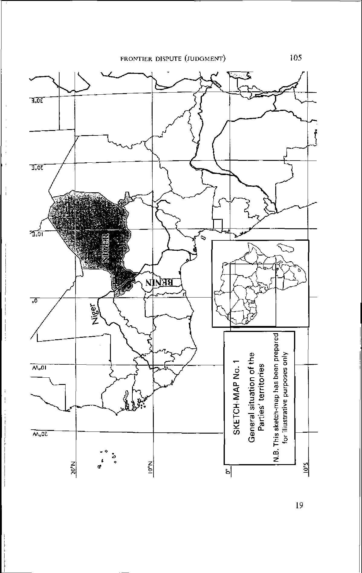
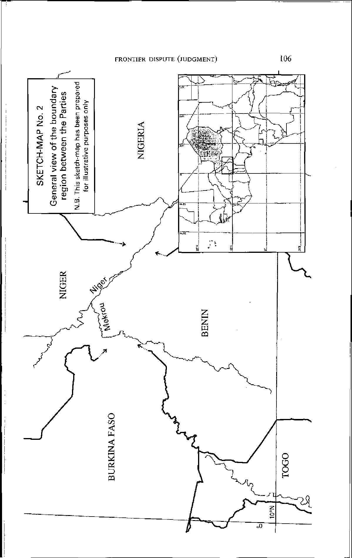
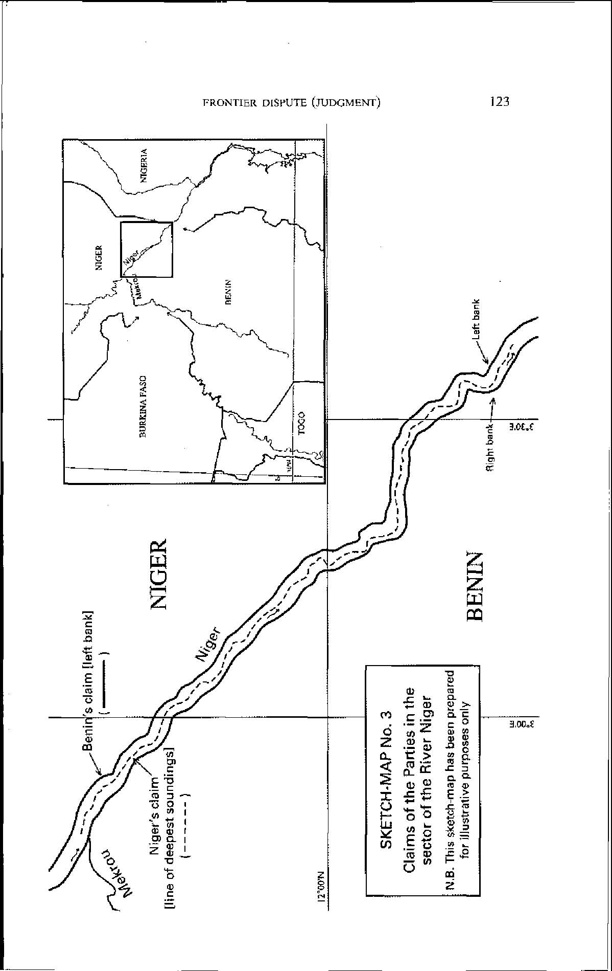
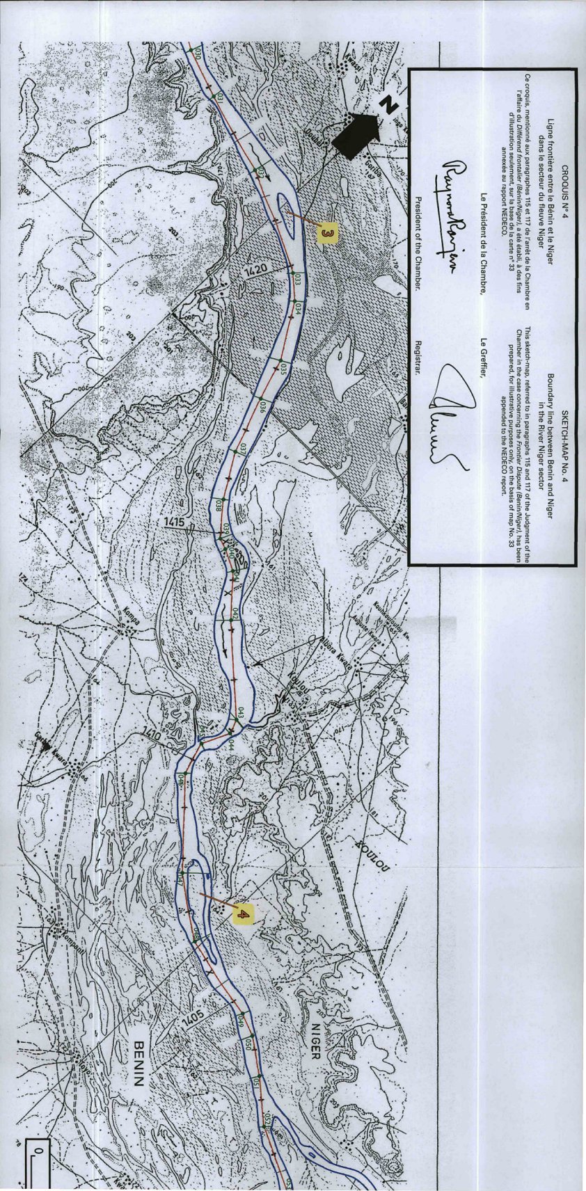
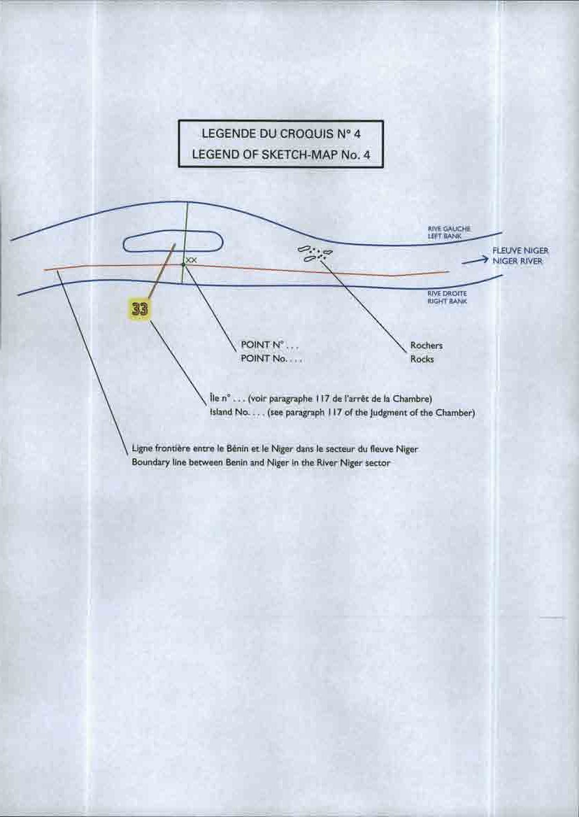