| |
[p625]
THE COURT,
composed as above,
after deliberation,
delivers the following Judgment:
1. By joint letter dated 30 September 1998, filed in the Registry of the
Court on 2 November 1998, the Ministers for Foreign Affairs of the Republic
of Indonesia (hereinafter "Indonesia") and of Malaysia notified to the
Registrar a Special Agreement between the two States, signed at Kuala Lumpur
on 31 May 1997 and having entered into force on 14 May 1998, the date of the
exchange of instruments of ratification.
2. The text of the Special Agreement reads as follows:
"The Government of the Republic of Indonesia and the Government of Malaysia,
hereinafter referred to as 'the Parties';
Considering that a dispute has arisen between them regarding sovereignty
over Pulau Ligitan and Pulau Sipadan;
Desiring that this dispute should be settled in the spirit of friendly
relations existing between the Parties as enunciated in the 1976 Treaty of
Amity and Co-operation in Southeast Asia; and
Desiring further, that this dispute should be settled by the International
Court of Justice (the Court),
Have agreed as follows:
Article 1
Submission of Dispute
The Parties agree to submit the dispute to the Court under the terms of
Article 36, paragraph 1, of its Statute.
Article 2
Subject of the Litigation
The Court is requested to determine on the basis of the treaties, agreements
and any other evidence furnished by the Parties, whether sovereignty over
Pulau Ligitan and Pulau Sipadan belongs to the Republic of Indonesia or to
Malaysia.
Article 3
Procedure
1. Subject to the time-limits referred to in paragraph 2 of this Article,
the proceedings shall consist of written pleadings and oral hearings in
accordance with Article 43 of the Statute of the Court.
2. Without prejudice to any question as to the burden of proof and having
regard to Article 46 of the Rules of Court, the written pleadings should
consist of: [p631]
(a) a Memorial presented simultaneously by each of the Parties not later
than 12 months after the notification of this Special Agreement to the
Registry of the Court;
(b) a Counter-Memorial presented by each of the Parties not later than 4
months after the date on which each has received the certified copy of the
Memorial of the other Party;
(c) a Reply presented by each of the Parties not later than 4 months after
the date on which each has received the certified copy of the
Counter-Memorial of the other Party; and
(d) a Rejoinder, if the Parties so agree or if the Court decides ex officio
or at the request of one of the Parties that this part of the proceedings is
necessary and the Court authorizes or prescribes the presentation of a
Rejoinder.
3. The above-mentioned written pleadings and their annexes presented to the
Registrar will not be transmitted to the other Party until the Registrar has
received the part of the written pleadings corresponding to the said Party.
4. The question of the order of speaking at the oral hearings shall be
decided by mutual agreement between the Parties or, in the absence of that
agreement, by the Court. In all cases, however, the order of speaking
adopted shall be without prejudice to any question regarding the burden of
proof.
Article 4
Applicable Law
The principles and rules of international law applicable to the dispute
shall be those recognized in the provisions of Article 38 of the Statute of
the Court.
Article 5
Judgment of the Court
The Parties agree to accept the Judgment of the Court given pursuant to this
Special Agreement as final and binding upon them.
Article 6
Entry into Force
1. This Agreement shall enter into force upon the exchange of instruments of
ratification. The date of exchange of the said instruments shall be
determined through diplomatic channels.
2. This Agreement shall be registered with the Secretariat of the United
Nationspursuant to Article 102 of the Charter of the United Nations, jointly
or by either of the Parties.
Article 7
Notification
In accordance with Article 40 of the Statute of the Court, this Special
Agreement shall be notified to the Registrar of the Court by a joint letter
from the Parties as soon as possible after it has entered into force.
In witness whereof the undersigned, being duly authorized thereto by their
respective Governments, have signed the present Agreement." [p632]
3. Pursuant to Article 40, paragraph 3, of the Statute of the Court, copies
of the joint notification and of the Special Agreement were transmitted by
the Registrar to the Secretary-General of the United Nations, the Members of
the United Nations and other States entitled to appear before the Court.
4. By an Order dated 10 November 1998, the Court, having regard to the
provisions of the Special Agreement concerning the written pleadings, fixed
2 November 1999 and 2 March 2000 as the respective time-limits for the
filing by each of the Parties of a Memorial and then a Counter-Memorial. The
Memorials were filed within the prescribed time-limit. By joint letter of 18
August 1999, the Parties asked the Court to extend to 2 July 2000 the
time-limit for the filing of their Counter-Memorials. By an Order dated 14
September 1999, the Court agreed to that request. By joint letter of 8 May
2000, the Parties asked the Court for a further extension of one month to
the time-limit for the filing of their Counter-Memorials. By Order of 11 May
2000, the President of the Court also agreed to that request. The Parties'
Counter-Memorials were filed within the time-limit as thus extended.
5. Under the terms of the Special Agreement, the two Parties were to file a
Reply not later than four months after the date on which each had received
the certified copy of the Counter-Memorial of the other Party. By joint
letter dated 14 October 2000, the Parties asked the Court to extend this
time-limit by three months. By an Order dated 19 October 2000, the President
of the Court fixed 2 March 2001 as the time-limit for the filing by each of
the Parties of a Reply. The Replies were filed within the prescribed
time-limit. In view of the fact that the Special Agreement provided for the
possible filing of a fourth pleading by each of the Parties, the latter
informed the Court by joint letter of 28 March 2001 that they did not wish
to produce any further pleadings. Nor did the Court itself ask for such
pleadings.
6. Since the Court included upon the Bench no judge of the nationality of
either of theParties, each Party proceeded to exercise the right conferred
by Article 31, paragraph 3, of the Statute to choose a judge ad hoc to sit
in the case: Indonesia chose Mr. Mohamed Shahabuddeen and Malaysia Mr.
Christopher Gregory Weeramantry.
7. Mr. Shahabuddeen, judge ad hoc, having resigned from that function on 20
March 2001, Indonesia informed the Court, by letter received in the Registry
on 17 May 2001, that its Government had chosen Mr. Thomas Franck to replace
him.
8. On 13 March 2001, the Republic of the Philippines filed in the Registry
of the Court an Application for permission to intervene in the case,
invoking Article 62 of the Statute of the Court. By a Judgment rendered on
23 October 2001, the Court found that the Application of the Philippines
could not be granted.
9. During a meeting which the President of the Court held on 6 March 2002
with the Agents of the Parties, in accordance with Article 31 of the Rules
of Court, the Agents made known the views of their Governments with regard
to various aspects relating to the organization of the oral proceedings. In
particular, they stated that the Parties had agreed to suggest to the Court
that Indonesia should present its oral arguments first, it being understood
that this in no way implied that Indonesia could be considered the applicant
State or Malaysia the respondent State, nor would it have any effect on
questions concerning the burden of proof.
Further to this meeting, the Court, taking account of the views of the
Parties, fixed Monday 3 June 2002, at 10 a.m., as the date for the opening
of the hear-[p633]ings, and set a timetable for them. By letters dated 7
March 2002, the Registrar informed the Agents of the Parties accordingly.
10. Pursuant to Article 53, paragraph 2, of the Rules of Court, the Court,
after ascertaining the views of the Parties, decided that copies of the
pleadings and documents annexed would be made accessible to the public on
the opening of the oral proceedings.
11. Public hearings were held from 3 to 12 June 2002, at which the Court
heard the oral arguments and replies of:
For Indonesia: H.E. Mr. Hassan Wirajuda,
Sir Arthur Watts,
Mr. Alfred H. A. Soons,
Mr. Alain Pellet,
Mr. Rodman R. Bundy,
Ms Loretta Malintoppi.
For Malaysia: H.E. Mr. Tan Sri Abdul Kadir Mohamad,
H.E. Dato' Noor Farida Ariffin,
Sir Elihu Lauterpacht,
Mr. Nico Schrijver,
Mr. James Crawford,
Mr. Jean-Pierre Cot.
*
12. In the course of the written proceedings, the following submissions were
presented by the Parties:
On behalf of the Government of Indonesia,
in the Memorial, Counter-Memorial and Reply:
"On the basis of the considerations set out in this [Reply], the Government
of the Republic of Indonesia requests the Court to adjudge and declare that:
(a) sovereignty over Pulau Ligitan belongs to the Republic of Indonesia; and
(b) sovereignty over Pulau Sipadan belongs to the Republic of Indonesia."
On behalf of the Government of Malaysia,
in the Memorial, Counter-Memorial and Reply:
"In the light of the considerations set out above, Malaysia respectfully
requests the Court to adjudge and declare that sovereignty over Pulau
Ligitan and Pulau Sipadan belongs to Malaysia."
13. At the oral proceedings, the following submissions were presented by the
Parties:
On behalf of the Government of Indonesia,
"On the basis of the facts and legal considerations presented in Indonesia's
written pleadings and in its oral presentation, the Government of the
Republic of Indonesia respectfully requests the Court to adjudge and declare
that:
(i) sovereignty over Pulau Ligitan belongs to the Republic of Indonesia; and
[p634]
(ii) sovereignty over Pulau Sipadan belongs to the Republic of Indonesia."
On behalf of the Government of Malaysia,
"The Government of Malaysia respectfully requests the Court to adjudge and
declare that sovereignty over Pulau Ligitan and Pulau Sipadan belongs to
Malaysia."
***
14. The islands of Ligitan and Sipadan (Pulau Ligitan and Pulau Sipadan) are
both located in the Celebes Sea, off the north-east coast of the island of
Borneo, and lie approximately 15.5 nautical miles apart (see below, pp.13
and 14, sketch-maps Nos. 1 and 2).
Ligitan is a very small island lying at the southern extremity of a large
star-shaped reef extending southwards from the islands of Danawan and Si
Amil. Its co-ordinates are 4 [degree] 09' latitude north and 118 [degree]
53' longitude east. The island is situated some 21 nautical miles from
Tanjung Tutop, on the Semporna Peninsula, the nearest area on Borneo.
Permanently above sea level and mostly sand, Ligitan is an island with
low-lying vegetation and some trees. It is not permanently inhabited.
Although bigger than Ligitan, Sipadan is also a small island, having an area
of approximately 0.13 sq. km. Its co-ordinates are 4 [degree] 06' latitude
north and 118 [degree] 37' longitude east. It is situated some 15 nautical
miles from Tanjung Tutop, and 42 nautical miles from the east coast of the
island of Sebatik. Sipadan is a densely wooded island of volcanic origin and
the top of a submarine mountain some 600 to 700 m in height, around which a
coral atoll has formed. It was not inhabited on a permanent basis until the
1980s, when it was developed into a tourist resort for scuba-diving.
*
15. The dispute between the Parties has a complex historical background, of
which an overview will now be given by the Court.
In the sixteenth century Spain established itself in the Philippines and
sought to extend its influence to the islands lying further to the south.
Towards the end of the sixteenth century it began to exercise its influence
over the Sultanate of Sulu.
On 23 September 1836 Spain concluded Capitulations of peace, protection and
commerce with the Sultan of Sulu. In these Capitulations, Spain guaranteed
its protection to the Sultan
"in any of the islands situated within the limits of the Spanish
jurisdiction, and which extend from the western point of Mindanao
(Magindanao) to Borneo and Paragua (Palawan), with the exception of Sandakan
and the other territories tributary to the Sultan on the island of Borneo".
[p635]
Sketch Map No. 1. General Georgraphical
Setting
[p636]
Sketch-Map No. 2. Location of Ligitan and
Sipadan Islands
[p637]
On 19 April 1851, Spain and the Sultan of Sulu concluded an "Act of
Re-Submission" whereby the island of Sulu and its dependencies were annexed
by the Spanish Crown. That Act was confirmed on 22 July 1878 by a Protocol
whereby the Sultan recognized "as beyond discussion the sovereignty of Spain
over all the Archipelago of Sulu and the dependencies thereof".
16. For its part, the Netherlands established itself on the island of Borneo
at the beginning ofthe seventeenth century. The Netherlands East India
Company, which possessed considerable commercial interests in the region,
exercised public rights in South-East Asia under a charter granted to it in
1602 by the Netherlands United Provinces. Under the Charter, the Company was
authorized to "conclude conventions with Princes and Powers" of the region
in the name of the States-General of the Netherlands. Those conventions
mainly involved trade issues, but they also provided for the acceptance of
the Company's suzerainty or even the cession to it by local sovereigns of
all or part of their territories.
When the Netherlands East India Company established itself on Borneo in the
seventeenth and eighteenth centuries, the influence of the Sultan of
Banjermasin extended over large portions of southern and eastern Borneo. On
the east coast, the territory under the control of Banjermasin included the
"Kingdom of Berou", composed of three "States": Sambaliung, Gunungtabur and
Bulungan. The Sultans of Brunei and Sulu exercised their influence over the
northern part of Borneo.
Upon the demise of the Netherlands East India Company at the end of the
eighteenth century, all of its territorial possessions were transferred to
the Netherlands United Provinces. During the Napoleonic wars, Great Britain
took control of the Dutch possessions in Asia. Pursuant to the London
Convention of 13 August 1814, the newly formed Kingdom of the Netherlands
recovered most of the former Dutch possessions.
17. A Contract was concluded by the Netherlands with the Sultan of
Banjermasin on 3 January 1817. Article 5 of this Contract provided for inter
alia the cession to the Netherlands of Berou ("Barrau") and of all its
dependencies. On 13 September 1823, an addendum was concluded, amending
Article 5 of the 1817 Contract.
On 4 May 1826 a new Contract was concluded. Article 4 thereof reconfirmed
the cession to the Netherlands of Berou ("Barou") and of its dependencies.
Over the following years, the three territories that formed the Kingdom of
Berou, Sambaliung, Gunungtabur and Bulungan, were separated. By a
Declaration of 27 September 1834, the Sultan of Bulungan submitted directly
to the authority of the Netherlands East Indies Government. In 1844 the
three territories were each recognized by the Government of the Netherlands
as separate Kingdoms. Their chiefs were officially accorded the title of
Sultan. [p638]
18. In 1850 the Government of the Netherlands East Indies concluded with the
sultans of the three kingdoms "contracts of vassalage", under which the
territory of their respective kingdoms was granted to them as a fief. The
Contract concluded with the Sultan of Bulungan is dated 12 November 1850.
A description of the geographical area constituting the Sultanate of
Bulungan appeared for the first time in the Contract of 12 November 1850.
Article 2 of that Contract described the territory of Bulungan as follows:
"The territory of Boeloengan is located within the following boundaries:
-- with Goenoeng-Teboer: from the seashore landwards, the Karangtiegau River
from its mouth up to its origin; in addition, the Batoe Beokkier and Mount
Palpakh;
-- with the Sulu possessions: at sea the cape named Batoe Tinagat, as well
as the Tawau River.
The following islands shall belong to Boeloengan: Terakkan, Nenoekkan and
Sebittikh, with the small islands belonging thereto.
This delimitation is established provisionally, and shall be completely
examined and determined again."
A new Contract of Vassalage was concluded on 2 June 1878. It was approved
and ratified by the Governor-General of the Netherlands East Indies on 18
October 1878.
Article 2 of the 1878 Contract of Vassalage described the territory of
Bulungan as follows: "The territory of the realm of Boeloengan is deemed to
be constituted by the lands and islands as described in the statement
annexed to this contract." The text of the statement annexed to the contract
is virtually identical to that of Article 2 of the 1850 Contract.
This statement was amended in 1893 to bring it into line with the 1891
Convention between Great Britain and the Netherlands (see paragraph 23
below). The new statement provided that:
"The Islands of Tarakan and Nanoekan and that portion of the Island of
Sebitik, situated to the south of the above boundary-line, described in the
'Indisch Staatsblad' of 1892, No. 114, belong to Boeloengan, as well as the
small islands belonging to the above islands, so far as they are situated to
the south of the boundary-line . . ."
19. Great Britain, for its part, possessed commercial interests in the area
but had no established settlements on Borneo until the nineteenth century.
After the Anglo-Dutch Convention of 13 August 1814, the commercial and
territorial claims of Great Britain and the Netherlands on Borneo began to
overlap.
On 17 March 1824 Great Britain and the Netherlands signed a new [p639]
Treaty in an attempt to settle their commercial and territorial disputes in
the region.
20. In 1877, the Sultan of Brunei made three separate instruments in which
he "granted" Mr. Alfred Dent and Baron von Overbeck a large area of North
Borneo. Since these grants included a portion of territory along the north
coast of Borneo which was also claimed by the Sultan of Sulu, Alfred Dent
and Baron von Overbeck decided to enter into an agreement with the latter
Sultan.
On 22 January 1878 the Sultan of Sulu agreed to "grant and cede" to Alfred
Dent and Baron von Overbeck, as representatives of a British company, all
his rights and powers over:
"all the territories and lands being tributary to [him] on the mainland of
the Island of Borneo, commencing from the Pandassan River on the west coast
to Maludu Bay, and extending along the whole east coast as far as the Sibuco
River in the south, comprising all the provinces bordering on Maludu Bay,
also the States of Pietan, Sugut, Bangaya, Labuk, Sandakan, Kinabatangan,
Mamiang, and all the other territories and states to the southward thereof
bordering on Darvel Bay and as far as the Sibuco River, with all the islands
belonging thereto within three marine leagues [9 nautical miles] of the
coast".
On the same day, the Sultan of Sulu signed a commission whereby he appointed
Baron von Overbeck "Dato' Bndahara and Rajah of Sandakan" with "the fullest
power of life and death" over all the inhabitants of the territories which
had been granted to him and made him master of "all matters . . . and [of]
the revenues or 'products'" belonging to the Sultan in those territories.
The Sultan of Sulu asked the "foreign nations" with which he had concluded
"friendly treaties and alliances" to accept "the said Dato' Bndahara as
supreme ruler over the said dominions".
Baron von Overbeck subsequently relinquished all his rights and interests in
the British company referred to above. Alfred Dent later applied for a Royal
Charter from the British Government to administer the territory and exploit
its resources. This Charter was granted in November 1881. In May 1882 a
chartered company was officially incorporated under the name of the "British
North Borneo Company" (hereinafter the "BNBC").
The BNBC began at that time to extend its administration to certain islands
situated beyond the 3-marine-league limit referred to in the 1878 grant.
21. On 11 March 1877 Spain, Germany and Great Britain concluded a Protocol
establishing free commerce and navigation in the Sulu (Jolo) Sea with a view
to settling a commercial dispute which had arisen between them. Under this
Protocol, Spain undertook to guarantee and ensure the liberty of commerce,
of fishing and of navigation for ships and subjects of Great Britain,
Germany and the other Powers in "the Archi=[p640]pelago of Sulu (Jolo) and
in all parts there[of]", without prejudice to the rights recognized to Spain
in the Protocol.
On 7 March 1885 Spain, Germany and Great Britain concluded a new Protocol of
which the first three articles read as follows:
"Article 1
The Governments of Germany and Great Britain recognize the sovereignty of
Spain over the places effectively occupied, as well as over those places not
yet so occupied, of the archipelago of Sulu (Jolo), of which the boundaries
are determined in Article 2.
Article 2
The Archipelago of Sulu (Jolo), conformably to the definition contained in
Article 1 of the Treaty signed the 23rd of September 1836, between the
Spanish Government and the Sultan of Sulu (Jolo), comprises all the islands
which are found between the western extremity of the island of Mindanao, on
the one side, and the continent of Borneo and the island of Paragua, on the
other side, with the exception of those which are indicated in
Article 3.
It is understood that the islands of Balabac and of Cagayan-Jolo form part
of the Archipelago.
Article 3
The Spanish Government relinquishes as far as regards the British
Government, all claim of sovereignty over the territories of the continent
of Borneo which belong, or which have belonged in the past, to the Sultan of
Sulu (Jolo), including therein the neighboring islands of Balambangan,
Banguey and Malawali, as well as all those islands lying within a zone of
three marine leagues along the coasts and which form part of the territories
administered by the Company styled the 'British North Borneo Company'."
22. On 12 May 1888 the British Government entered into an Agreement with the
BNBC for the creation of the State of North Borneo. This Agreement made
North Borneo a British Protectorate, with the British Government assuming
responsibility for its foreign relations.
23. On 20 June 1891 the Netherlands and Great Britain concluded a Convention
(hereinafter the "1891 Convention") for the purpose of "defining the
boundaries between the Netherland possessions in the Island of Borneo and
the States in that island which [were] under British protection" (see
paragraph 36 below).
24. At the end of the Spanish-American War, Spain ceded the Philippine
Archipelago (see paragraph 115 below) to the United States of America
(hereinafter the "United States") through the Treaty of Peace of Paris of 10
December 1898 (hereinafter the "1898 Treaty of Peace"). Article III of the
Treaty defined the Archipelago by means of certain lines. Under the Treaty
of 7 November 1900 (hereinafter the "1900 [p641] Treaty"), Spain ceded to
the United States "all islands belonging to the Philippine Archipelago,
lying outside the lines described in Article III" of the 1898 Treaty of
Peace (see paragraph 115 below).
25. On 22 April 1903 the Sultan of Sulu concluded a "Confirmation of
Cession" with the Government of British North Borneo, in which were
specified the names of a certain number of islands which were to be treated
as having been included in the original cession granted to Alfred Dent and
Baron von Overbeck in 1878. The islands mentioned were as follows:
Muliangin, Muliangin Kechil, Malawali, Tegabu, Bilian, Tegaypil, Lang Kayen,
Boan, Lehiman, Bakungan, Bakungan Kechil, Libaran, Taganack, Beguan,
Mantanbuan, Gaya, Omadal, Si Amil, Mabol, Kepalai and Dinawan. The
instrument further provided that "other islands near, or round, or lying
between the said islands named above" were included in the cession of 1878.
All those islands were situated beyond the 3-marine-league limit.
26. Following a visit in 1903 by the US Navy vessel USS Quiros to the area
of the islands disputed in the present proceedings, the BNBC lodged protests
with the Foreign Office, on the ground that some of the islands visited, on
which the US Navy had placed flags and tablets, were, according to the BNBC,
under its authority. The question was dealt with in particular in a
memorandum dated 23 June 1906 from Sir H. M. Durand, British Ambassador to
the United States, to the United States Secretary of State, with which a map
showing "the limits within which the [BNBC] desire[d] to carry on the
administration" was enclosed. Under an Exchange of Notes dated 3 and 10 July
1907, the United States temporarily waived the right of administration in
respect of "all the islands to the westward and southwestward of the line
traced on the map which accompanied Sir H. M. Durand's memorandum".
27. On 28 September 1915 Great Britain and the Netherlands, acting pursuant
to Article V of the 1891 Convention, signed an Agreement relating to "the
Boundary Between the State of North Borneo and the Netherland Possessions in
Borneo" (hereinafter the "1915 Agreement"), whereby the two States confirmed
a report and accompanying map prepared by a mixed commission set up for the
purpose (see paragraphs 70, 71 and 72 below).
On 26 March 1928 Great Britain and the Netherlands signed another agreement
(hereinafter the "1928 Agreement") pursuant to Article V of the 1891
Convention, for the purpose of "further delimiting part of the frontier
established in article III of the Convention signed at London on the 20th
June, 1891" ("between the summits of the Gunong Api and of the Gunong
Raya"); a map was attached to that agreement (see paragraph 73 below).
28. On 2 January 1930 the United States and Great Britain concluded a
Convention (hereinafter the "1930 Convention") "delimiting . . . the
boundary between the Philippine Archipelago . . . and the State of North
Borneo" (see paragraph 119 below). This Convention contained five
[p642] articles, of which the first and third are the most relevant for the
purposes of the present case. Article I defined the line separating the
islands which belonged to the Philippine Archipelago and those which
belonged to the State of North Borneo; Article III stipulated as follows:
"All islands to the north and east of the said line and all islands and
rocks traversed by the said line, should there be any such, shall belong to
the Philippine Archipelago and all islands to the south and west of the said
line shall belong to the State of North Borneo."
29. On 26 June 1946 the BNBC entered into an agreement with the British
Government whereby the Company transferred its interests, powers and rights
in respect of the State of North Borneo to the British Crown. The State of
North Borneo then became a British colony.
30. On 9 July 1963 the Federation of Malaya, the United Kingdom of Great
Britain and Northern Ireland, North Borneo, Sarawak and Singapore concluded
an Agreement relating to Malaysia. Under Article I of this Agreement, which
entered into force on 16 September 1963, the colony of North Borneo was to
be "federated with the existing States of the Federation of Malaya as the
[State] of Sabah".
31. After their independence, Indonesia and Malaysia began to grant oil
prospecting licences in waters off the east coast of Borneo during the
1960s. The first oil licence granted by Indonesia to a foreign company in
the relevant area took the form of a production sharing agreement concluded
on 6 October 1966 between the Indonesian State-owned company P. N.
Pertambangan Minjak Nasional ("Permina") and the Japan Petroleum Exploration
Company Limited ("Japex"). The northern boundary of one of the areas covered
by the agreement ran eastwards in a straight line from the east coast of
Sebatik Island, following the parallel 4 [degree] 09' 30" latitude north for
some 27 nautical miles out to sea. In 1968 Malaysia in turn granted various
oil prospecting licences to Sabah Teiseki Oil Company ("Teiseki"). The
southern boundary of the maritime concession granted to Teiseki was located
at 4 [degree] 10' 30" latitude north.
The present dispute crystallized in 1969 in the context of discussions
concerning the delimitation of the respective continental shelves of the two
States. Following those negotiations a delimitation agreement was reached on
27 October 1969. It entered into force on 7 November 1969. However, it did
not cover the area lying to the east of Borneo.
In October 1991 the two Parties set up a joint working group to study the
situation of the islands of Ligitan and Sipadan. They did not however reach
any agreement and the issue was entrusted to special emissaries of the two
Parties who, in June 1996, recommended by mutual agreement that the dispute
should be referred to the International Court of Justice. The Special
Agreement was signed on 31 May 1997.
*** [p643]
32. Indonesia's claim to sovereignty over the islands of Ligitan and Sipadan
rests primarily on the 1891 Convention between Great Britain and the
Netherlands. It also relies on a series of effectivites, both Dutch and
Indonesian, which it claims confirm its conventional title. At the oral
proceedings Indonesia further contended, by way of alternative argument,
that if the Court were to reject its title based on the 1891 Convention, it
could still claim sovereignty over the disputed islands as successor to the
Sultan of Bulungan, because he had possessed authority over the islands.
33. For its part, Malaysia contends that it acquired sovereignty over the
islands of Ligitan and Sipadan following a series of alleged transmissions
of the title originally held by the former sovereign, the Sultan of Sulu.
Malaysia claims that the title subsequently passed, in succession, to Spain,
to the United States, to Great Britain on behalf of the State of North
Borneo, to the United Kingdom of Great Britain and Northern Ireland, and
finally to Malaysia itself. It argues that its title, based on this series
of legal instruments, is confirmed by a certain number of British and
Malaysian effectivites over the islands. It argues in the alternative that,
if the Court were to conclude that the disputed islands had originally
belonged to the Netherlands, its effectivites would in any event have
displaced any such Netherlands title.
***
34. As the Court has just noted, Indonesia's main claim is that sovereignty
over the islands of Ligitan and Sipadan belongs to it by virtue of the 1891
Convention. Indonesia maintains that "the Convention, by its terms, its
context, and its object and purpose, established the 4 [degree] 10' N
parallel of latitude as the dividing line between the Parties' respective
possessions in the area now in question". It states in this connection that
its position is not that "the 1891 Convention line was from the outset
intended also to be, or in effect was, a maritime boundary . . . east of
Sebatik island" but that "the line must be considered an allocation line:
land areas, including islands located to the north of 4 [degree] 10' N
latitude were . . . considered to be British, and those lying to the south
were Dutch". As the disputed islands lie to the south of that parallel, "it
therefore follows that under the Convention title to those islands vested in
The Netherlands, and now vests in Indonesia".
Indonesia contends that the two States parties to the 1891 Convention
clearly assumed that they were the only actors in the area. It adds in this
regard that Spain had no title to the islands in dispute and had shown no
interest in what was going on to the south of the Sulu Archipelago.
In Indonesia's view, the Convention did not involve territorial cessions;
rather, each party's intention was to recognize the other party's title to
territories on Borneo and islands lying "on that party's side" of
[p644]
the line, and to relinquish any claim in respect of them. According to
Indonesia, "both parties no doubt considered that [the] territories . . . on
their side of the agreed line were already theirs, rather than that they had
become theirs by virtue of a treaty cession". It maintains that in any case,
whatever may have been the position before 1891, the Convention between the
two colonial Powers is an indisputable title which takes precedence over any
other pre-existing title.
35. For its part, Malaysia considers that Indonesia's claim to Ligitan and
Sipadan finds no support in either the text of the 1891 Convention or in its
travaux preparatoires, or in any other document that may be used to
interpret the Convention. Malaysia points out that the 1891 Convention, when
seen as a whole, clearly shows that the parties sought to clarify the
boundary between their respective land possessions on the islands of Borneo
and Sebatik, since the line of delimitation stops at the easternmost point
of the latter island. It contends that "the ordinary and natural
interpretation of the Treaty, and relevant rules of law, plainly refute"
Indonesia's argument and adds that the ratification of the 1891 Convention
and its implementation, notably through the 1915 Agreement, do not support
Indonesia's position.
Malaysia additionally argues that, even if the 1891 Convention were
construed so as to allocate possessions to the east of Sebatik, that
allocation could not have any consequence in respect of islands which
belonged to Spain at the time. In Malaysia's view, Great Britain could not
have envisioned ceding to the Netherlands islands which lay beyond the
3-marine-league line referred to in the 1878 grant, a line said to have been
expressly recognized by Great Britain and Spain in the Protocol of 1885.
**
36. On 20 June 1891, the Netherlands and Great Britain signed a Convention
for the purpose of "defining the boundaries between the Netherland
possessions in the Island of Borneo and the States in that island which
[were] under British protection". The Convention was drawn up in Dutch and
in English, the two texts being equally authentic. It consists of eight
articles. Article I stipulates that "the boundary between the Netherland
possessions in Borneo and those of the British-protected States in the same
island, shall start from 4 [degree] 10' north latitude on the east coast of
Borneo". Article II, after stipulating "the boundary-line shall be continued
westward", then describes the course of the first part of that line. Article
III describes the further westward course of the boundary line from the
point where Article II stops and as far as Tandjong-Datoe, on the west coast
of Borneo. Article V provides that "the exact positions of the
boundary-line, as described in the four preceding Articles, shall be [p645]
determined hereafter by mutual agreement, at such times as the Netherland
and the British Governments may think fit". Article VI guarantees the
parties free navigation on all rivers flowing into the sea between
Batoe-Tinagat and the River Siboekoe. Article VII grants certain rights to
the population of the Sultanate of Bulungan to the north of the boundary.
Lastly, Article VIII stipulates the conditions in which the Convention would
come into force.
Indonesia relies essentially on Article IV of the 1891 Convention in support
of its claim to the islands of Ligitan and Sipadan. That provision reads as
follows:
"From 4 [degree] 10' north latitude on the east coast the boundary-line
shall be continued eastward along that parallel, across the Island of
Sebittik: that portion of the island situated to the north of that parallel
shall belong unreservedly to the British North Borneo Company, and the
portion south of that parallel to the Netherlands."
The Parties disagree over the interpretation to be given to that provision.
*
37. The Court notes that Indonesia is not a party to the Vienna Convention
of 23 May 1969 on the Law of Treaties; the Court would nevertheless recall
that, in accordance with customary international law, reflected in Articles
31 and 32 of that Convention:
"a treaty must be interpreted in good faith in accordance with the ordinary
meaning to be given to its terms in their context and in the light of its
object and purpose. Interpretation must be based above all upon the text of
the treaty. As a supplementary measure recourse may be had to means of
interpretation such as the preparatory work of the treaty and the
circumstances of its conclusion." (Territorial Dispute (Libyan Arab
Jamahiriya/Chad), Judgment, I.C.J. Reports 1994, pp. 21-22, para. 41; see
also Maritime Delimitation and Territorial Questions between Qatar and
Bahrain (Qatar v. Bahrain), Jurisdiction and Admissibility, Judgment, I.C.J.
Reports 1995, p. 18, para. 33; Oil Platforms (Islamic Republic of Iran v.
United States of America), Preliminary Objection, Judgment, I.C.J. Reports
1996 (II), p. 812, para. 23; Kasikili/Sedudu Island (Botswana/Namibia),
Judgment, I.C.J. Reports 1999 (II), p. 1059, para. 18.)
Moreover, with respect to Article 31, paragraph 3, the Court has had
occasion to state that this provision also reflects customary law,
stipulating that there shall be taken into account, together with the
context, the subsequent conduct of the parties to the treaty, i.e., "any
subsequent agreement" (subpara. (a)) and "any subsequent practice" (subpara.
(b))(see in particular Legality of the Use by a State of Nuclear Weapons in
[p646] Armed Conflict, Advisory Opinion, I.C.J. Reports 1996 (I), p. 75,
para. 19; Kasikili/Sedudu Island (Botswana/Namibia), Judgment, I.C.J.
Reports 1999 (II), p. 1075, para. 48).
Indonesia does not dispute that these are the applicable rules. Nor is the
applicability of the rule contained in Article 31, paragraph 2, contested by
the Parties.
38. The Court will now proceed to the interpretation of Article IV of the
1891 Convention in the light of these rules.
**
39. With respect to the terms of Article IV, Indonesia maintains that this
Article contains nothing to suggest that the line stops at the east coast of
Sebatik Island. On the contrary, it contends that "the stipulation that the
line was to be 'continued' eastward along the prescribed parallel [, across
the island of Sebatik,] requires a prolongation of the line so far as was
necessary to achieve the Convention's purposes". In this respect, Indonesia
points out that had the parties to the Convention intended not to draw an
allocation line out to sea to the east of Sebatik (see paragraph 34 above)
but to end the line at a point on the coast, they would have stipulated this
expressly, as was the case in Article III.
Moreover, Indonesia notes a difference in punctuation between the Dutch and
English texts of Article IV of the Convention, both texts being authentic
(see paragraph 36 above), and bases itself on the English text, which reads
as follows:
"From 4 [degree] 10' north latitude on the east coast the boundary-line
shall be continued eastward along that parallel, across the Island of
Sebittik: that portion of the island situated to the north of that parallel
shall belong unreservedly to the British North Borneo Company, and the
portion south of that parallel to the Netherlands."
Indonesia emphasizes the colon in the English text, claiming that it is used
to separate two provisions of which the second develops or illustrates the
first. It thus contends that the second part of the sentence, preceded by
the colon, "is essentially a subsidiary part of the sentence, filling out
part of its meaning, but not distorting the clear sense of the main clause,
which takes the line out to sea along the 4 [degree] 10' N parallel".
40. Malaysia, for its part, contends that when Article IV of the 1891
Convention provides that the boundary line continues eastward along the
parallel of 4 [degree] 10' north, this simply means "that the extension
starts from the east coast of Borneo and runs eastward across Sebatik, in
contrast with the main part of the boundary line, which starts at the same
point, but runs westwards". According to Malaysia, the plain and ordinary
meaning of the words "across the Island of Sebittik" is to describe, "in
English and in Dutch, a line that crosses Sebatik from the west coast [p647] to the east coast and goes no further". Malaysia moreover rejects the
idea that the parties to the 1891 Convention intended to establish an
"allocation perimeter", that is to say a "theoretical line drawn in the high
seas under a convention which enables sovereignty over the islands lying
within the area in question to be apportioned between the parties". Malaysia
adds that "allocation perimeters" cannot be presumed where the text of a
treaty remains silent in such respect, as in the case of the 1891
Convention, which contains no such indication.
In regard to the difference in punctuation between the Dutch and English
texts of Article IV of the Convention, Malaysia, for its part, relies on the
Dutch text, which reads as follows:
"Van 4 [degree] [10' noorder breedte ter oostkust zal de grenslijn
oostwaarts vervolgd worden langs die parallel over het eiland Sebittik; het
gedeelte van dat eiland dat gelegen is ten noorden van die parallel zal
onvoorwaardelijk toebehooren aan de Brittsche Noord Borneo Maatschappij, en
het gedeelte ten zuiden van die parallel aan Nederland".
Malaysia contends that the drafting of this provision as "a single sentence
divided into two parts only by a semi-colon indicates the close grammatical
and functional connection between the two parts". Thus, in Malaysia's view,
the second clause of the sentence, which relates exclusively to the division
of the island of Sebatik, confirms that the words "across the Island of
Sebittik" refer solely to that island.
41. The Court notes that the Parties differ as to how the preposition
"across" (in the English) or "over" (in the Dutch) in the first sentence of
Article IV of the 1891 Convention should be interpreted. It acknowledges
that the word is not devoid of ambiguity and is capable of bearing either of
the meanings given to it by the Parties. A line established by treaty may
indeed pass "across" an island and terminate on the shores of such island or
continue beyond it.
The Parties also disagree on the interpretation of the part of the same
sentence which reads "the boundary-line shall be continued eastward along
that parallel [4 [degree] 10' north]". In the Court's view, the phrase
"shall be continued" is also not devoid of ambiguity. Article I of the
Convention defines the starting point of the boundary between the two
States, whilst Articles II and III describe how that boundary continues from
one part to the next. Therefore, when Article IV provides that "the
boundary-line shall be continued" again from the east coast of Borneo along
the 4 [degree] 10' N parallel and across the island of Sebatik, this does
not, contrary to Indonesia's contention, necessarily mean that the line
continues as an allocation line beyond Sebatik.
The Court moreover considers that the difference in punctuation in the two
versions of Article IV of the 1891 Convention does not as such help [p648]
elucidate the meaning of the text with respect to a possible extension of
the line out to sea, to the east of Sebatik Island (see also paragraph 56
below).
42. The Court observes that any ambiguity could have been avoided had the
Convention expressly stipulated that the 4 [degree] 10' N parallel
constituted, beyond the east coast of Sebatik, the line separating the
islands under British sovereignty from those under Dutch sovereignty. In
these circumstances, the silence in the text cannot be ignored. It supports
the position of Malaysia.
43. It should moreover be observed that a "boundary", in the ordinary
meaning of the term, does not have the function that Indonesia attributes to
the allocation line that was supposedly established by Article IV out to sea
beyond the island of Sebatik, that is to say allocating to the parties
sovereignty over the islands in the area. The Court considers that, in the
absence of an express provision to this effect in the text of a treaty, it
is difficult to envisage that the States parties could seek to attribute an
additional function to a boundary line.
*
44. Indonesia asserts that the context of the 1891 Convention supports its
interpretation of Article IV of that instrument. In this regard, Indonesia
refers to the "interaction" between the British Government and the Dutch
Government concerning the map accompanying the Explanatory Memorandum
annexed by the latter to the draft Law submitted to the States-General
[48] of the Netherlands with a view to the ratification of the 1891
Convention and the "purpose of [which] was to explain to the States-General
the significance of a proposed treaty, and why its conclusion was in the
interests of The Netherlands". Indonesia contends that this map, showing the
prolongation out to sea to the east of Sebatik of the line drawn on land
along the 4 [degree] 10' north parallel, was forwarded to the British
Government by its own diplomatic agent and that it was known to that
Government. In support of this Indonesia points out that "Sir Horace
Rumbold, the British Minister at The Hague, sent an official despatch back
to the Foreign Office on 26 January 1892 with which he sent two copies of
the map: and he drew specific attention to it". According to Indonesia, this
official transmission did not elicit any reaction from the Foreign Office.
Indonesia accordingly concludes that this implies Great Britain's
"irrefutable acquiescence in the depiction of the Convention line", and
thereby its acceptance that the 1891 Convention divided up the islands to
the east of Borneo between Great Britain and the Netherlands. In this
respect, Indonesia first maintains that this "interaction", in terms of
Article 31, paragraph 2 (a), of the Vienna Convention on the Law of
Treaties, "establishes an agreement between the two governments regarding
the seaward course of the Anglo-Dutch boundary east of Sebatik". It also
considers that this "interaction" shows that the map in question was, within
the meaning of Article 31, paragraph 2 (b), of the [p649] Vienna
Convention, an instrument made by the Dutch Government in connection with
the conclusion of the 1891 Convention, particularly its Articles IV and
VIII, and was accepted by the British Government as an instrument related to
the treaty. In support of this twofold argument, Indonesia states inter alia
that "[the map] was officially prepared by the Dutch Government immediately
after the conclusion of the 1891 Convention and in connection with its
approval by the Netherlands States-General as specifically required by
Article VIII of the Convention", that "it was publicly and officially
available at the time", and that "the British Government, in the face of its
official knowledge of the map, remained silent".
45. For its part, Malaysia contends that the map attached to the Dutch
Government's Explanatory Memorandum cannot be regarded as an element of the
context of the 1891 Convention. In Malaysia's view, that map was prepared
exclusively for internal purposes. Malaysia notes in this respect that the
map was never promulgated by the Dutch authorities and that neither the
Government nor the Parliament of the Netherlands sought to incorporate it
into the Convention; the Dutch act of ratification says nothing to such
effect.
Malaysia moreover argues that the map in question was never the subject of
negotiations between the two Governments and was never officially
communicated by the Dutch Government to the British Government. Malaysia
adds that, even if the British Government had been made aware of this map
through the intermediary of its Minister in The Hague, the circumstances
"did not call for any particular reaction, as the map had not been mentioned
in the parliamentary debate and no one had noted the extension of the
boundary-line out to sea". Malaysia concludes from this that the map in
question was not "an Agreement or an Instrument 'accepted by the other party
and related to the treaty'".
46. The Court considers that the Explanatory Memorandum appended to the
draft Law submitted to the Netherlands States-General with a view to
ratification of the 1891 Convention, the only document relating to the
Convention to have been published during the period when the latter was
concluded, provides useful information on a certain number of points.
First, the Memorandum refers to the fact that, in the course of the prior
negotiations, the British delegation had proposed that the boundary line
should run eastwards from the east coast of North Borneo, passing between
the islands of Sebatik and East Nanukan. It further indicates that the
Sultan of Bulungan, to whom, according to the Netherlands, the mainland
areas of Borneo then in issue between Great Britain and the Netherlands
belonged, had been consulted by the latter before the Convention was
concluded. Following this consultation, the Sultan had asked for his people
to be given the right to gather jungle produce free of tax within the area
of the island to be attributed to the State of North Borneo; such right was
accorded for a 15-year period by Article VII of the [p650] Convention. As
regards Sebatik, the Memorandum explains that the island's partition had
been agreed following a proposal by the Dutch Government and was considered
necessary in order to provide access to the coastal regions allocated to
each party. The Memorandum contains no reference to the disposition of other
islands lying further to the east, and in particular there is no mention of
Ligitan or Sipadan.
47. As regards the map appended to the Explanatory Memorandum, the Court
notes that this shows four differently coloured lines. The blue line
represents the boundary initially claimed by the Netherlands, the yellow
line the boundary initially claimed by the BNBC, the green line the boundary
proposed by the British Government and the red line the boundary eventually
agreed. The blue and yellow lines stop at the coast; the green line
continues for a short distance out to sea, whilst the red line continues out
to sea along parallel 4 [degree] 10' N to the south of Mabul Island. In the
Explanatory Memorandum there is no comment whatever on this extension of the
red line out to sea; nor was it discussed in the Dutch Parliament.
The Court notes that the map shows only a number of islands situated to the
north of parallel 4 [degree] 10'; apart from a few reefs, no island is shown
to the south of that line. The Court accordingly concludes that the Members
of the Dutch Parliament were almost certainly unaware that two tiny islands
lay to the south of the parallel and that the red line might be taken for an
allocation line. In this regard, the Court notes that there is nothing in
the case file to suggest that Ligitan and Sipadan, or other islands such as
Mabul, were territories disputed between Great Britain and the Netherlands
at the time when the Convention was concluded. The Court cannot therefore
accept that the red line was extended in order to settle any dispute in the
waters beyond Sebatik, with the consequence that Ligitan and Sipadan were
attributed to the Netherlands.
48. Nor can the Court accept Indonesia's argument regarding the legal value
of the map appended to the Explanatory Memorandum of the Dutch Government.
The Court observes that the Explanatory Memorandum and map were never
transmitted by the Dutch Government to the British Government, but were
simply forwarded to the latter by its diplomatic agent in The Hague, Sir
Horace Rumbold. This agent specified that the map had been published in the
Official Journal of The Netherlands and formed part of a Report presented to
the Second Chamber of the States-General. He added that "the map seems to be
the only interesting feature of a document which does not otherwise call for
special comment". However, Sir Horace Rumbold did not draw the attention of
his authorities to the red line drawn on the map among other lines. The
British Government did not react to this internal transmission. In these
circumstances, such a lack of reaction to this line on the map appended to
the Memorandum cannot be deemed to constitute acquiescence in this line. [p651]
It follows from the foregoing that the map cannot be considered either an
"agreement relating to [a] treaty which was made between all the parties in
connection with the conclusion of the treaty", within the meaning of Article
31, paragraph 2 (a), of the Vienna Convention, or an "instrument which was
made by [a] part[y] in connection with the conclusion of the treaty and
accepted by the other parties as an instrument related to that treaty",
within the meaning of Article 31, paragraph 2 (b), of the Vienna Convention.
*
49. Turning to the object and purpose of the 1891 Convention, Indonesia
argues that the parties' intention was to draw an allocation line between
their island possessions in the north-eastern region of Borneo, including
the islands out at sea.
It stresses that the main aim of the Convention was "to resolve the
uncertainties once and for all so as to avoid future disputes". In this
respect, Indonesia invokes the case law of the Court and that of its
predecessor, the Permanent Court of International Justice. According to
Indonesia, the finality and completeness of boundary settlements were relied
on by both Courts, on several occasions, as a criterion for the
interpretation of treaty provisions. In particular, Indonesia cites the
Advisory Opinion of the Permanent Court on the Interpretation of Article 3,
Paragraph 2, of the Treaty of Lausanne (1925), which states:
"It is . . . natural that any article designed to fix a frontier should, if
possible, be so interpreted that the result of the application of its
provisions in their entirety should be the establishment of a precise,
complete and definitive frontier." (Interpretation of Article 3, Paragraph
2, of the Treaty of Lausanne, Advisory Opinion, 1925, P.C.I.J., Series B,
No. 12, p. 20.)
Indonesia puts forward a number of other arguments to justify its
interpretation of the Convention's object and purpose. It points out that
"in the preamble to the 1891 Convention the parties stated that they were
'desirous of defining the boundaries' (in the plural) between the Dutch and
British possessions in Borneo" and argues that this must be taken to mean
not only the island of Borneo itself but also other island territories.
Indonesia thus contends that the line established by Article IV of the
Convention concerned not only the islands which are the subject of the
dispute now before the Court but also other islands in the area. Moreover,
Indonesia notes that, while Article IV did not establish an endpoint for the
line -- providing for the line to extend eastward of the island of Sebatik
--, that does not mean that the line extends indefinitely eastward. In
Indonesia's opinion, the limit to its eastward extent was determined by the
purpose of the Convention, [p652] "the settlement, once and for all, of
possible Anglo-Dutch territorial differences in the region".
50. Malaysia, on the other hand, maintains that the object and purpose of
the 1891 Convention, as shown by its preamble, were to "defin[e] the
boundaries between the Netherlands possessions in the island of Borneo and
the States in that island which are under British protection". Referring to
the provisions concerning the island of Sebatik, Malaysia moreover adds that
one of the concerns of the negotiators of the Convention was also to ensure
access to the rivers -- the only possible means at the time of penetrating
the interior of Borneo -- and freedom of navigation. Malaysia thus concludes
that the 1891 Convention, when read as a whole, reveals unambiguously that
"it was intended to be a land boundary treaty", as nothing in it suggests
that it was intended to divide sea areas or to allocate distant offshore
islands.
51. The Court considers that the object and purpose of the 1891 Convention
was the delimitation of boundaries between the parties' possessions within
the island of Borneo itself, as shown by the preamble to the Convention,
which provides that the parties were "desirous of defining the boundaries
between the Netherland possessions in the Island of Borneo and the States in
that island which are under British protection" (emphasis added by the
Court). This interpretation is, in the Court's view, supported by the very
scheme of the 1891 Convention. Article I expressly provides that "the
boundary . . . shall start from 4 [degree] 10' north latitude on the east
coast of Borneo" (emphasis added by the Court). Articles II and III then
continue the description of the boundary line westward, with its endpoint on
the west coast being fixed by Article III. Since difficulties had been
encountered concerning the status of the island of Sebatik, which was
located directly opposite the starting point of the boundary line and
controlled access to the rivers, the parties incorporated an additional
provision to settle this issue. The Court does not find anything in the
Convention to suggest that the parties intended to delimit the boundary
between their possessions to the east of the islands of Borneo and Sebatik
or to attribute sovereignty over any other islands. As far as the islands of
Ligitan and Sipadan are concerned, the Court also observes that the terms of
the preamble to the 1891 Convention are difficult to apply to these islands
as they were little known at the time, as both Indonesia and Malaysia have
acknowledged, and were not the subject of any dispute between Great Britain
and the Netherlands.
*
52. The Court accordingly concludes that the text of Article IV of the 1891
Convention, when read in context and in the light of the Convention's object
and purpose, cannot be interpreted as establishing an alloca-[p653]tion
line determining sovereignty over the islands out to sea, to the east of the
island of Sebatik.
**
53. In view of the foregoing, the Court does not consider it necessary to
resort to supplementary means of interpretation, such as the travaux
preparatoires of the 1891 Convention and the circumstances of its
conclusion, to determine the meaning of that Convention; however, as in
other cases, it considers that it can have recourse to such supplementary
means in order to seek a possible confirmation of its interpretation of the
text of the Convention (see for example Territorial Dispute (Libyan Arab
Jamahiriya/Chad), I.C.J. Reports 1994, p. 27, para. 55; Maritime
Delimitation and Territorial Questions between Qatar and Bahrain (Qatar v.
Bahrain), Jurisdiction and Admissibility, Judgment, I.C.J. Reports 1995, p.
21, para. 40).
54. Indonesia begins by recalling that prior to the conclusion of the 1891
Convention the Sultan of Bulungan had
"clear claims . . . to inland areas north of the Tawau coast and well to the
north of 4 [degree] 10' N, which were acknowledged by Great Britain in
agreeing, in Article VII of the 1891 Convention, to the Sultan having
certain continuing transitional rights to jungle produce".
It adds that the Netherlands engaged in "activity in the area evidencing
Dutch claims to sovereignty extending to the north of the eventual 4[degree]
10' N line". It further notes "the prevailing uncertainty at the time as to
the precise extent of the territories belonging to the two parties" and
mentions "the occurrence of occasional Anglo-Dutch confrontations as a
result of these uncertainties".
Indonesia moreover maintains that the travaux preparatoires of the 1891
Convention, though containing no express indication as to whether Ligitan
and Sipadan were British or Dutch, confirm its interpretation of Article IV.
In Indonesia's view, there can be no doubt that during the negotiations
leading up to the signature of the Convention the two parties, and in
particular Great Britain, envisaged a line continuing out to sea to the east
of the island of Borneo. In support of this argument, Indonesia submits
several maps used by the parties' delegations during the negotiations. It
considers that these maps "show a consistent pattern of the line of proposed
settlement, wherever it might finally run, being extended out to sea along a
relevant parallel of latitude".
55. Malaysia rejects Indonesia's analysis of the travaux preparatoires. In
its view, "the consideration of the boundary on the coast never extended to
cover the islands east of Batu Tinagat". Malaysia further [p654] considers
that the travaux preparatoires of the 1891 Convention make clear that the
line proposed to divide Sebatik Island "was a boundary line, not an
allocation line", that the line "was adopted as a compromise only after the
4 [degree] 10' N line was agreed as a boundary line for the mainland of
Borneo", and that the line in question "related only to the island of
Sebatik and not to other islands well to the east". Malaysia points out that
in any event this could not have been a matter of drawing a "boundary line"
in the open seas because at the time in question maritime delimitation could
not extend beyond territorial waters.
56. The Court observes that following its formation, the BNBC asserted
rights which it believed it had acquired from Alfred Dent and Baron von
Overbeck to territories situated on the north-eastern coast of the island of
Borneo (in the State of Tidoeng "as far south as the Sibuco River");
confrontations then occurred between the Company and the Netherlands, the
latter asserting its rights to the Sultan of Bulungan's possessions, "with
inclusion of the Tidoeng territories" (emphasis in the original). These were
the circumstances in which Great Britain and the Netherlands set up a Joint
Commission in 1889 to discuss the bases for an agreement to settle the
dispute. Specifically, the Commission was appointed "to take into
consideration the question of the disputed boundary between the Netherland
Indian possessions on the north-east coast of the Island of Borneo and the
territory belonging to the British North Borneo Company" (emphasis added by
the Court). It was moreover provided that "in the event of a satisfactory
understanding", the two governments would define the "inland boundary-lines
which separate the Netherland possessions in Borneo from the territories
belonging to the States of Sarawak, Brunei, and the British North Borneo
Company respectively" (emphasis added by the Court). The Joint Commission's
task was thus confined to the area in dispute, on the north-eastern coast
of Borneo. Accordingly, it was agreed that, once this dispute had been
settled, the inland boundary could be determined completely, as there was
clearly no other point of disagreement between the parties.
The Joint Commission met three times and devoted itself almost exclusively
to questions relating to the disputed area of the north-east coast. It was
only at the last meeting, held on 27 July 1889, that the British delegation
proposed that the boundary should pass between the islands of Sebatik and
East Nanukan. This was the first proposal of any prolongation of the inland
boundary out to sea. The Court however notes from the diplomatic
correspondence exchanged after the Commission was dissolved that it follows
that the Netherlands had rejected the British proposal. The specific idea of
Sebatik Island being divided along the 4 [degree] 10' N parallel was only
introduced later. In a letter of 2 February 1891 to the British Secretary
for Foreign Affairs from the Dutch Minister in London, the latter stated
that the Netherlands agreed with this partition. The Sec-[p655]retary for
Foreign Affairs, in his reply dated 11 February 1891, acknowledged this
understanding and enclosed a draft agreement. Article 4 of the draft is
practically identical in its wording to Article IV of the 1891 Convention.
In the draft agreement (proposed by Great Britain) the two sentences of
Article 4 are separated by a semicolon. In the final English text, the
semicolon was replaced by a colon without the travaux preparatoires shedding
any light on the reasons for this change. Consequently, no firm inference
can be drawn from the change. There were no further difficulties and the
Convention was signed on 20 June 1891.
57. During the negotiations, the parties used various sketch-maps to
illustrate their proposals and opinions. Some of these sketch-maps showed
lines drawn in pencil along certain parallels and continuing as far as the
margin. Since the reports accompanying the sketch-maps do not provide any
further explanation, the Court considers that it is impossible to deduce
anything at all from the length of these lines.
There is however one exception. In an internal Foreign Office memorandum,
drafted in preparation for the meeting of the Joint Commission, the
following suggestion was made:
"Starting eastward from a point A on the coast near Broers Hoek on parallel
4 [degree] 10' of North Latitude, the line should follow that parallel until
it is intersected by . . . the Meridian 117 [degree] 50' East Longitude,
opposite the Southernmost point of the Island of Sebattik at the point
marked C. The line would continue thence in an Easterly direction along the
4th parallel, until it should meet the point of intersection of the Meridian
of 118 [degree] 44' 30" marked D."
This suggestion was illustrated on a map that is reproduced as map No. 4 of
Indonesia's map atlas. Sipadan is to the west of point D and Ligitan to the
east of this point. Neither of the two islands appears on the map. The Court
observes that there is nothing in the case file to prove that the suggestion
was ever brought to the attention of the Dutch Government or that the line
between points C and D had ever been the subject of discussion between the
parties. Although put forward in one of the many British internal documents
drawn up during the negotiations, the suggestion was never actually adopted.
Once the parties arrived at an agreement on the partition of Sebatik, they
were only interested in the boundary on the island of Borneo itself and
exchanged no views on an allocation of the islands in the open seas to the
east of Sebatik.
58. The Court concludes from the foregoing that neither the travaux
preparatoires of the Convention nor the circumstances of its conclusion can
be regarded as supporting the position of Indonesia when it contends that
the parties to the Convention agreed not only on the course of the[p656]
land boundary but also on an allocation line beyond the east coast of
Sebatik.
**
59. Concerning the subsequent practice of the parties to the 1891
Convention, Indonesia refers once again to the Dutch Government's
Explanatory Memorandum map accompanying the draft of the Law authorizing the
ratification of the Convention (see paragraphs 47 and 48 above). Indonesia
considers that this map can also be seen as "a subsequent agreement or as
subsequent practice for the purposes of Article 31.3 (a) and (b) of the
Vienna Convention" on the Law of Treaties.
60. Malaysia points out that the Explanatory Memorandum map submitted by the
Dutch Government to the two Chambers of the States-General, on which
Indonesia bases its argument, was not annexed to the 1891 Convention, which
made no mention of it. Malaysia concludes that this is not a map to which
the parties to the
[67] Convention agreed. It further notes that "the internal Dutch map
attached to the Explanatory Memorandum was the object of no specific comment
during the [parliamentary] debate and did not call for any particular
reaction". Thus, according to Malaysia, this map cannot be seen as "a
subsequent agreement or as subsequent practice for the purposes of Article
31.3 (a) and (b) of the Vienna Convention" on the Law of Treaties.
61. The Court has already given consideration (see paragraph 48 above) to
the legal force of the map annexed to the Dutch Government's Explanatory
Memorandum accompanying the draft Law submitted by it for the ratification
of the 1891 Convention. For the same reasons as those on which it based its
previous findings, the Court considers that this map cannot be seen as "a
subsequent agreement or as subsequent practice for the purposes of Article
31.3 (a) and (b) of the Vienna Convention".
*
62. In Indonesia's view, the 1893 amendment to the 1850 and 1878 Contracts
of Vassalage with the Sultan of Bulungan provides a further indication of
the interpretation given by the Netherlands Government to the 1891
Convention. It asserts that the aim of the amendment was to redefine the
territorial extent of the Sultanate of Bulungan to take into account the
provisions of the 1891 Convention. According to the new definition of 1893,
"the Islands of Tarakan and Nanoekan and that portion of the Island of
Sebitik, situated to the south of the above boundary-line . . . belong to
Boeloengan, as well as the small islands belonging to the above islands, so
far as they are situated to the south of [p657] the boundary-line . . ."
According to Indonesia, this text indicates that the Netherlands Government
considered in 1893 that the purpose of the 1891 Convention was to establish,
in relation to islands, a line of territorial attribution extending out to
sea. Indonesia adds that the British Government showed acquiescence in this
interpretation, because the text of the 1893 amendment was officially
communicated to the British Government on 26 February 1895 without meeting
with any reaction.
63. Malaysia observes that the small islands referred to in the 1893
amendment are those which "belong" to the three expressly designated
islands, namely Tarakan, Nanukan and Sebatik, and which are situated to the
south of the boundary thus determined. Malaysia stresses that it would be
fanciful "to see this as establishing an allocation perimeter projected 50
miles out to sea".
64. The Court observes that the relations between the Netherlands and the
Sultanate of Bulungan were governed by a series of contracts entered into
between them. The Contracts of 12 November 1850 and 2 June 1878 laid down
the limits of the Sultanate. These limits extended to the north of the land
boundary that was finally agreed in 1891 between the Netherlands and Great
Britain. For this reason the Netherlands had consulted the Sultan before
concluding the Convention with Great Britain and was moreover obliged in
1893 to amend the 1878 Contract in order to take into account the
delimitation of 1891. The new text stipulated that the islands of Tarakan
and Nanukan, and that portion of the island of Sebatik situated to the south
of the boundary line, belonged to Bulungan, together with "the small islands
belonging to the above islands, so far as they are situated to the south of
the boundary-line". The Court observes that these three islands are
surrounded by many smaller islands that could be said to "belong" to them
geographically. The Court, however, considers that this cannot apply to
Ligitan and Sipadan, which are situated more than 40 nautical miles away
from the three islands in question. The Court observes that in any event
this instrument, whatever its true scope may have been, was res inter alios
acta for Great Britain and therefore it could not be invoked by the
Netherlands in its treaty relations with Great Britain.
*
65. Indonesia also cites the Agreement concluded between Great Britain and
the Netherlands on 28 September 1915, pursuant to Article V of the 1891
Convention, concerning the boundary between the State of North Borneo and
the Dutch possessions on Borneo. It stresses that this was a demarcation
agreement which, by definition, could only concern the inland part of the
boundary. According to Indonesia, the fact that this Agreement does not
mention the boundary eastward of the island of Sebatik does not imply that
the 1891 Convention did not establish an eastward boundary out to sea. It
states that, unlike in the case of the islands of Borneo and Sebatik, where
demarcation was [p658] physically possible, such an operation was not
possible in the sea east of Sebatik.
Finally, Indonesia asserts that the fact that the Commissioners' work
started at the east coast of Sebatik does not mean that the 1891 Convention
line began there, any more than the fact that their work ended after
covering some 20 per cent of the boundary can be interpreted to mean that
the boundary did not continue any further. It states that, contrary to what
Malaysia suggests, the Commissioners' report did not say that the boundary
started on the east coast of Sebatik but indicated only that "traversing the
island of Sibetik, the frontier line follows the parallel of 4 [degree] 10'
north latitude . . .".
66. Indonesia contends that the same applies to the 1928 Agreement, whereby
the parties to the 1891 Convention agreed on a more precise delimitation of
the boundary, as defined in Article III of the Convention, between the
summits of the Gunong Api and of the Gunong Raya.
67. With respect to the maps attached to the 1915 and 1928 Agreements,
Indonesia acknowledges that they showed no seaward extension of the line
along the 4 [degree] 10' N parallel referred to in Article IV of the 1891
Convention. It further recognizes that these maps formed an integral part of
the agreements and that as such they therefore had the same binding legal
force as those agreements for the parties. Indonesia nevertheless stresses
that the maps attached to the 1915 and 1928 Agreements should in no sense be
considered as prevailing over the Dutch Explanatory Memorandum map of 1891
in relation to stretches of the 1891 Convention line which were beyond the
reach of the 1915 and 1928 Agreements.
68. Malaysia does not share Indonesia's interpretation of the 1915 and 1928
Agreements between Great Britain and the Netherlands. On the contrary, it
considers that these Agreements contradict Indonesia's interpretation of
Article IV of the 1891 Convention.
With respect to the 1915 Agreement, Malaysia points out that the Agreement
"starts by stating that the frontier line traverses the island of Sebatik
following the parallel of 4 [degree] 10' N latitude marked on the east and
west coasts by boundary pillars, then follows the parallel westward". In
Malaysia's view, this wording "is exclusive of any prolongation of the line
eastward". Further, Malaysia maintains that the map referred to in the
preamble to the Agreement and annexed to it confirms that the boundary line
started on the east coast of Sebatik Island and did not concern Ligitan or
Sipadan. In this respect, it observes that on this map the eastern extremity
of the boundary line is situated on the east coast of Sebatik and that the
map shows no sign of the line being extended out to sea. Malaysia points
out, however, that from the western endpoint of the boundary the map shows
the beginning of a continuation due south. Malaysia concludes from this that
"if the Commissioners had thought the [1891 Convention] provided for an
extension of the boundary line [p659] eastwards by an allocation line, they
would have likewise indicated the beginning of such a line" as they had done
at the other end of the boundary. Malaysia stresses that the Commissioners
not only chose not to extend the line on the map but they even indicated the
end of the boundary line on the map by a red cross. Malaysia adds that the
evidentiary value of the map annexed to the 1915 Agreement is all the
greater because it is "the only official map agreed by the Parties".
At the hearings, Malaysia further contended that the 1915 Agreement could
not be considered exclusively as a demarcation agreement. It explained that
the Commissioners did not perform an exercise of demarcation stricto sensu,
as they took liberties with the text of the 1891 Convention at a number of
points on the land boundary, and these liberties were subsequently endorsed
by the signatories of the 1915 Agreement. As an example, Malaysia referred
to the change made by the Commissioners to the boundary line in the channel
between the west coast of Sebatik and mainland Borneo, for the purpose of
reaching the middle of the mouth of the River Troesan Tamboe.
69. With respect to the 1928 Agreement, which pertains to an inland sector
of the boundary between the summits of the Gunong Api and the Gunong Raya,
Malaysia considers that this instrument confirms the 1915 Agreement, since
the Netherlands Government could have taken the opportunity to correct the
1915 map and Agreement if it had so wished.
70. The Court will recall that the 1891 Convention included a clause
providing that the parties would in the future be able to define the course
of the boundary line more exactly. Thus, Article V of the Convention states:
"The exact positions of the boundary-line, as described in the four
preceding Articles, shall be determined hereafter by mutual agreement, at
such times as the Netherland and the British Governments may think fit."
The first such agreement was the one signed at London by Great Britain and
the Netherlands on 28 September 1915 relating to "the boundary between the
State of North Borneo and the Netherland possessions in Borneo". As
explained in an exchange of letters of 16 March and 3 October 1905 between
Baron Gericke, Netherlands Minister in London, and the Marquess of
Lansdowne, British Foreign Secretary, and in a communication dated 19
November 1910 from the Netherlands Charge d'affaires, the origin of that
agreement was a difference of opinion between the Netherlands and Great
Britain in respect of the course of the boundary line. The difference
concerned the manner in which Article II of the 1891 Convention should be
interpreted. That provision was, by way of the 1905 exchange of letters,
given an interpretation agreed by the two Governments. In 1910, the
Netherlands Minister for the Colonies made known to the Foreign Office, by
way of the above-mentioned communication from the Netherlands Charge
d'affaires, his view that "the time [p660] [had] come to open the
negotiations with the British Government mentioned in the [Convention] of
June 20, 1891, concerning the indication of the frontier between British
North Borneo and the Netherland Territory". He stated in particular that the
uncertainty as to the actual course of the boundary made itself felt "along
the whole" boundary. For that purpose, he proposed that "a mixed Commission
. . . be appointed to indicate the frontier on the ground, to describe it
and to prepare a map of same". As the proposal was accepted, a mixed
Commission carried out the prescribed task between 8 June 1912 and 30
January 1913.
71. By the 1915 Agreement, the two States approved and confirmed a joint
report, incorporated into that Agreement, and the map annexed thereto, which
had been drawn up by the mixed Commission. The Commissioners started their
work on the east coast of Sebatik and, from east to west, undertook to
"delimitate on the spot the frontier" agreed in 1891, as indicated in the
preamble to the Agreement. In the Court's view, the Commissioners'
assignment was not simply a demarcation exercise, the task of the parties
being to clarify the course of a line which could only be imprecise in view
of the somewhat general wording of the 1891 Convention and the line's
considerable length. The Court finds that the intention of the parties to
clarify the 1891 delimitation and the complementary nature of the
demarcation operations become very clear when the text of the Agreement is
examined carefully. Thus the Agreement indicates that "where physical
features did not present natural boundaries conformable with the provisions
of the Boundary Treaty of the 20th June, 1891, [the Commissioners] erected
the following pillars".
Moreover, the Court observes that the course of the boundary line finally
adopted in the 1915 Agreement does not totally correspond to that of the
1891 Convention. Thus, as Malaysia points out, whereas the sector of the
boundary between Sebatik Island and Borneo under Article IV of the 1891
Convention was to follow a straight line along the parallel of 4[degree] 10'
latitude north (see paragraph 36 above), the 1915 Agreement stipulates that:
"(2) Starting from the boundary pillar on the west coast of the island of
Sibetik, the boundary follows the parallel of 4o 10' north latitude westward
until it reaches the middle of the channel, thence keeping a mid-channel
course until it reaches the middle of the mouth of Troesan Tamboe.
(3) From the mouth of Troesan Tamboe the boundary line is continued up the
middle of this Troesan until it is intersected by a similar line running
through the middle of Troesan Sikapal; it then follows this line through
Troesan Sikapal as far as the point where the latter meets the watershed
between the Simengaris and Seroedong Rivers (Sikapal hill), and is connected
finally with this watershed by a line taken perpendicular to the centre line
of Troesan Sikapal".
In view of the foregoing, the Court cannot accept Indonesia's argu-[p661]ment that the 1915 Agreement was purely a demarcation agreement; nor can
it accept the conclusion drawn therefrom by Indonesia that the very nature
of this Agreement shows that the parties were not required to concern
themselves therein with the course of the line out to sea to the east of
Sebatik Island.
72. In connection with this agreement, the Court further notes a number of
elements which, when taken as a whole, suggest that the line established in
1891 terminated at the east coast of Sebatik.
It first observes that the title of the 1915 Agreement is very general in
nature ("Agreement between the United Kingdom and the Netherlands relating
to the Boundary between the State of North Borneo and the Netherland
Possessions in Borneo"), as is its wording. Thus, the preamble to the
Agreement refers to the joint report incorporated into the Agreement and to
the map accompanying it as "relating to the boundary between the State of
North Borneo and the Netherland possessions in the island", without any
further indication. Similarly, paragraphs 1 and 3 of the joint report state
that the Commissioners had "travelled in the neighbourhood of the frontier
from the 8th June, 1912, to the 30th January, 1913" and had
"determined the boundary between the Netherland territory and the State of
British North Borneo, as described in the Boundary Treaty supplemented by
the interpretation of Article 2 of the Treaty mutually accepted by the
Netherland and British Governments in 1905" (emphasis added by the Court).
For their part, the Commissioners, far from confining their examination to
the specific problem which had arisen in connection with the interpretation
of Article II of the 1891 Convention (see paragraph 70 above), also
considered the situation in respect of the boundary from Sebatik westward.
Thus, they began their task at the point where the 4 [degree] 10' latitude
north parallel crosses the east coast of Sebatik; they then simply proceeded
from east to west.
Moreover, subparagraph (1) of paragraph 3 of the joint report describes the
boundary line fixed by Article IV of the 1891 Convention as follows:
"Traversing the island of Sibetik, the frontier line follows the parallel of
4 [degree] 10' north latitude, as already fixed by Article 4 of the Boundary
Treaty and marked on the east and west coasts by boundary pillars" (emphasis
added by the Court).
In sum, the 1915 Agreement covered a priori the entire boundary "between the
Netherland territory and the State of British North Borneo" and the
Commissioners performed their task beginning at the eastern end of Sebatik.
In the opinion of the Court, if the boundary had continued in any way to the
east of Sebatik, at the very least some mention of that could have been
expected in the Agreement.
The Court considers that an examination of the map annexed to the [p662]
1915 Agreement reinforces the Court's interpretation of that Agreement. The
Court observes that the map, together with the map annexed to the 1928
Agreement, is the only one which was agreed between the parties to the 1891
Convention. The Court notes on this map that an initial southward extension
of the line indicating the boundary between the Netherlands possessions and
the other States under British protection is shown beyond the western
endpoint of the boundary defined in 1915, while a similar extension does not
appear beyond the point situated on the east coast of Sebatik; that latter
point was, in all probability, meant to indicate the spot where the boundary
ended.
73. A new agreement was concluded by the parties to the 1891 Convention on
26 March 1928. Although also bearing a title worded in general terms
("Convention between Great Britain and Northern Ireland and the Netherlands
respecting the Further Delimitation of the Frontier between the States in
Borneo under British Protection and the Netherlands Territory in that
Island"), that agreement had a much more limited object than the 1915
Agreement, as its Article 1 indicates:
"The boundary as defined in article III of the Convention signed at London
on the 20th June, 1891, is further delimited between the summits of the
Gunong Api and of the Gunong Raya as described in the following article and
as shown on the map attached to this Convention."
The Court considers this too to be an agreement providing for both a more
exact delimitation of the boundary in the sector in question and its
demarcation, not solely a demarcation treaty. However, the Court finds that
in 1928 it was a matter of carrying out the detailed delimitation and
demarcation of only a limited inland boundary sector. Accordingly, the Court
cannot draw any conclusions, for the purpose of interpreting Article IV of
the 1891 Convention, from the fact that the 1928 Agreement fails to make any
reference to the question of the boundary line being extended, as an
allocation line, out to sea east of Sebatik.
74. The Court lastly observes that no other agreement was concluded
subsequently by Great Britain and the Netherlands with respect to the course
of the line established by the 1891 Convention.
*
75. However, Indonesia refers to a debate that took place within the Dutch
Government between 1922 and 1926 over whether the issue of the delimitation
of the territorial waters off the east coast of the island of Sebatik should
be raised with the British Government. Indonesia sets out the various
options that had been envisaged in this respect: one of these options
consisted in considering that the 1891 Convention also established a
boundary for the territorial sea at 3 nautical miles from the coast. The
other option consisted in drawing a line perpendicular to the coast at [p663] the terminus of the land boundary, as recommended by the rules of
general international law that were applicable at the time. Indonesia adds
that the final view expressed in September 1926 by the Minister for Foreign
Affairs of the Netherlands, who had opted for the perpendicular line, was
that it was not opportune to raise the matter with the British Government.
According to Indonesia, this internal debate shows that the Dutch
authorities took the same position as Indonesia in the present case and saw
the 1891 line as an allocation line rather than a maritime boundary.
Indonesia further points out that the internal Dutch discussions were
entirely restricted to the delimitation of the territorial waters off
Sebatik Island and did not involve the islands of Ligitan and Sipadan.
76. Malaysia considers the proposal by certain Dutch authorities to delimit
the territorial waters by a line perpendicular to the coast from the
endpoint of the land boundary as particularly significant as this would have
made it more difficult for the Dutch Government to make any subsequent claim
to sovereignty over distant islands situated to the south of an allocation
line along the 4 [degree] 10' N parallel. Malaysia accordingly asserts that,
in view of this debate, it is difficult to argue that in 1926 the Dutch
authorities considered that any delimitation of territorial waters or the
course of an allocation line had been provided for by an agreement between
Great Britain and the Netherlands in 1891 or later. It further concludes
from this debate that the Dutch authorities were clearly of the view that no
rule of international law called for the prolongation, beyond the east coast
of Sebatik, of the 4 [degree] 10' N land boundary, and that in any event the
authorities did not favour such a solution, considering it to be contrary to
Dutch interests.
77. The Court notes that this internal debate sheds light on the views of
various Dutch authorities at the time as to the legal situation of the
territories to the east of Sebatik Island.
In a letter of 10 December 1922 to the Minister for the Colonies, the
Governor-General of the Dutch East Indies proposed certain solutions for the
delimitation of the territorial waters off the coast of Sebatik. One of
these solutions was to draw "a line which is an extension of the land
border". The Ministry of Foreign Affairs was also consulted. In a Memorandum
of 8 August 1923, it also mentioned the "extension of the land boundary"
dividing Sebatik Island as the possible boundary between Dutch territorial
waters and the territorial waters of the State of North Borneo. In support
of this solution, the Ministry of Foreign Affairs invoked the map annexed to
the Explanatory Memorandum, "on which the border between the areas under
Dutch and British jurisdiction on land and sea is extended along the
parallel 4 [degree] 10' N". The Ministry however added that "this map [did]
not result from actual consultation" between the parties, although it was
probably known to the British Government. Nevertheless, in his letter of 27
September 1926 to the Minister [p664] for the Colonies, the Minister for
Foreign Affairs, whilst not considering it desirable to raise the question
with the British Government, put forward the perpendicular line as being the
best solution. In the end this issue was not pursued and the Dutch
Government never drew it to the attention of the British Government.
In the Court's view, the above-mentioned correspondence suggests that, in
the 1920s, the best informed Dutch authorities did not consider that there
had been agreement in 1891 on the extension out to sea of the line drawn on
land along the 4 [degree] 10' north parallel.
*
78. Finally, Indonesia maintains that, in granting oil concessions in the
area, both Parties always respected the 4 [degree] 10' North latitude as
forming the limit of their respective jurisdiction. Accordingly, in
Indonesia's view, its grant of a licence to Japex/Total demonstrates that it
considered that its jurisdictional rights extended up to the 4 [degree] 10'
N line. Indonesia goes on to indicate that Malaysia acted in similar fashion
in 1968 when it granted an oil concession to Teiseki, pointing out that the
southern limit of this concession virtually coincides with that parallel.
Thus, according to Indonesia, the Parties recognized and respected the 4
[degree] 10' N parallel as a separation line between Indonesia's and
Malaysia's respective zones.
For its part, Malaysia notes that the oil concessions in the 1960s did not
concern territorial delimitation and that the islands of Ligitan and Sipadan
were never included in the concession perimeters. It adds that "no activity
pursuant to the Indonesian concessions had any relation to the islands".
79. The Court notes that the limits of the oil concessions granted by the
Parties in the area to the east of Borneo did not encompass the islands of
Ligitan and Sipadan. Further, the northern limit of the exploration
concession granted in 1966 by Indonesia and the southern limit of that
granted in 1968 by Malaysia did not coincide with the 4 [degree] 10' north
parallel but were fixed at 30" to either side of that parallel. These limits
may have been simply the manifestation of the caution exercised by the
Parties in granting their concessions. This caution was all the more natural
in the present case because negotiations were to commence soon afterwards
between Indonesia and Malaysia with a view to delimiting the continental
shelf.
The Court cannot therefore draw any conclusion for purposes of interpreting
Article IV of the 1891 Convention from the practice of the Parties in
awarding oil concessions.
*[p665]
80. In view of all the foregoing, the Court considers that an examination of
the subsequent practice of the parties to the 1891 Convention confirms the
conclusions at which the Court has arrived in paragraph 52 above as to the
interpretation of Article IV of that Convention.
81. Lastly, both Parties have produced a series of maps of various natures
and origins in support of their respective interpretations of Article IV of
the 1891 Convention.
82. Indonesia produces maps of "Dutch" or "Indonesian" origin, such as the
map annexed to the Dutch Explanatory Memorandum of 1891 and a map of Borneo
taken from an Indonesian atlas of 1953. Secondly, it produces "British" or
"Malaysian" maps, such as three maps published by Stanford in 1894, 1903 and
1904 respectively, a map of Tawau "produced by Great Britain in 1965", two
"maps of Malaysia of 1966 of Malaysian origin", a "Malaysian map of Semporna
published in 1967", the "official Malaysian map of the 1968 oil concessions
showing the international boundary", another map of Malaysia "published by
the Malaysian Directorate of National Mapping in 1972", etc. Thirdly,
Indonesia relies on a map from an American atlas of 1897 annexed by the
United States to its Memorial in the Island of Palmas Arbitration.
83. Indonesia contends that the maps it has produced "are consistent in
depicting the boundary line as extending offshore to the north of the known
locations of the islands of Ligitan and Sipadan, thus leaving them on what
is now the Indonesian side of the line". Indonesia stresses that "it was
only in 1979, well after the dispute had arisen, that Malaysia's maps began
to change in a self-serving fashion".
As regards the legal value of the maps it has produced, Indonesia considers
that a number of these maps fall into the category of the "physical
expressions of the will of the State or the States concerned" and that,
while "these maps do not constitute a territorial title by themselves, they
command significant weight in the light of their consistent depiction of the
1891 Treaty line as separating the territorial possessions, including the
islands, of the Parties".
84. In regard to the evidentiary value of the maps presented by Indonesia,
Malaysia states that "Indonesia has produced not a single Dutch or
Indonesian map, on any scale, which shows the islands and attributes them to
Indonesia". In Malaysia's view, contrary to what Indonesia contends, the
Dutch maps of 1897-1904 and of 1914 clearly show the boundary terminating at
the east coast of Sebatik. Malaysia emphasizes, moreover, that the
Indonesian official archipelagic claim map of 1960 clearly does not treat
the islands as Indonesian. Malaysia asserts that even Indonesian maps
published since 1969 do not show the islands as Indonesian. [p666] It does,
however, recognize that some modern maps might be interpreted in a contrary
sense, but it contends that these are relatively few in number and that
their legal force is reduced by the fact that each of them contains a
disclaimer in regard to the accuracy of the boundaries. Malaysia moreover
argues that on the majority of these latter maps the islands of Ligitan and
Sipadan are not shown at all, are in the wrong place, or are not shown as
belonging to Malaysia or to Indonesia.
85. In support of its interpretation of Article IV of the 1891 Convention,
Malaysia relies in particular on the map annexed to the 1915 Agreement
between the British and Netherlands Governments relating to the boundary
between the State of North Borneo and the Netherland possessions in Borneo:
according to Malaysia, this is the only official map agreed by the parties.
Malaysia also relies on a series of other maps of various origins. It first
presents a certain number of Dutch maps, including inter alia the map
entitled "East coast of Borneo: Island of Tarakan up to Dutch-English
boundary" dated 1905, two maps of 1913 showing the "administrative structure
of the Southern and Eastern Borneo Residence", the map made in 1917 "by the
Dutch official, Kaltofen", which, according to Malaysia, "is a hand-drawn
ethnographic map of Borneo", a map of "Dutch East Borneo" dated 1935, and
the 1941 map of "North Borneo". Secondly, it relies on certain maps of
British origin, that is to say the map published in 1952 by the "Colony of
North Borneo", the "schematic map" of administrative districts of the colony
of North Borneo dated 1953, and the map of "the Semporna police district of
1958, by S. M. Ross". Thirdly, it cites an Indonesian map: "Indonesia's
continental shelf map of 1960". Lastly, it also relies on a 1976 map of
Malaysian origin, entitled "Bandar Seri Begawan".
86. Malaysia considers that all of these maps clearly show that the boundary
line between the Dutch and British possessions in the area did not extend
into the sea east of Sebatik and that Ligitan and Sipadan were both
regarded, depending on the period, as being British or Malaysian islands.
87. In regard to the evidentiary value of the maps produced by Malaysia,
Indonesia contends, first, that virtually none of them actually shows
Ligitan and Sipadan as Malaysian possessions. It points out that the only
map which depicts the disputed islands as Malaysian possessions "is a map
prepared in 1979 to illustrate Malaysia's claim to the area". Indonesia
argues in this respect that this map, having been published ten years after
the dispute over the islands crystallized in 1969, is without legal
relevance in the case. Secondly, Indonesia points out that the maps relied
on by Malaysia, which do not depict the 1891 line as extending out to sea,
"are entirely neutral with respect to the territorial attribution of the
[p667] islands of Sipadan or Ligitan". As regards in particular the map
attached to the 1915 Agreement, Indonesia considers it logical that this map
should not show the line extending eastward of the island of Sebatik along
the 4 [degree] 10' N parallel, since it was concerned only with the
territorial situation on the island of Borneo. Finally, with reference to
the maps produced by Malaysia in its Memorial under the head of "Other
Maps", Indonesia asserts that none of these supports Malaysia's contentions
as to sovereignty over the two islands.
88. The Court would begin by recalling, as regards the legal value of maps,
that it has already had occasion to state the following:
"maps merely constitute information which varies in accuracy from case to
case; of themselves, and by virtue solely of their existence, they cannot
constitute a territorial title, that is, a document endowed by international
law with intrinsic legal force for the purpose of establishing territorial
rights. Of course, in some cases maps may acquire such legal force, but
where this is so the legal force does not arise solely from their intrinsic
merits: it is because such maps fall into the category of physical
expressions of the will of the State or States concerned. This is the case,
for example, when maps are annexed to an official text of which they form an
integral part. Except in this clearly defined case, maps are only extrinsic
evidence of varying reliability or unreliability which may be used, along
with other evidence of a circumstantial kind, to establish or reconstitute
the real facts." (Frontier Dispute (Burkina Faso/Republic of Mali),
Judgment, I.C.J. Reports 1986, p. 582, para. 54; Kasikili/Sedudu Island
(Botswana/Namibia), Judgment, I.C.J. Reports 1999 (II), p. 1098, para. 84).
In the present case, the Court observes that no map reflecting the agreed
views of the parties was appended to the 1891 Convention, which would have
officially expressed the will of Great Britain and the Netherlands as to the
prolongation of the boundary line, as an allocation line, out to sea to the
east of Sebatik Island.
89. In the course of the proceedings, the Parties made particular reference
to two maps: the map annexed to the Explanatory Memorandum appended by the
Netherlands Government to the draft Law submitted to the States-General for
the ratification of the 1891 Convention, and the map annexed to the 1915
Agreement. The Court has already set out its findings as to the legal value
of these maps (see paragraphs 47, 48 and 72 above).
90. Turning now to the other maps produced by the Parties, the Court
observes that Indonesia has submitted a certain number of maps published
after the 1891 Convention showing a line continuing out to sea off the
eastern coast of Sebatik Island, along the parallel of 4 [degree] 10'
latitude north. These maps include, for example, those of Borneo made by
Stanford in 1894, in 1903 and in 1904, and that of 1968 published by the [p668] Malaysian Ministry of Lands and Mines to illustrate oil-prospecting
licences.
The Court notes that the manner in which these maps represent the
continuation out to sea of the line forming the land boundary varies from
one map to another. Moreover, the length of the line extending out to sea
varies considerably: on some maps it continues for several miles before
stopping approximately halfway to the meridians of Ligitan and Sipadan,
whilst on others it extends almost to the boundary between the Philippines
and Malaysia.
For its part, Malaysia has produced various maps on which the boundary line
between the British and Dutch possessions in the region stops on the eastern
coast of Sebatik Island. These maps include the map of British North Borneo
annexed to the 1907 Exchange of Notes between Great Britain and the United
States, the Dutch map of 1913 representing the Administrative Structure of
the Southern and Eastern Borneo Residence, and the map showing the 1915
boundary line published in the Official Gazette of the Dutch Colonies in
1916.
The Court however considers that each of these maps was produced for
specific purposes and it is therefore unable to draw from those maps any
clear and final conclusion as to whether or not the line defined in Article
IV of the 1891 Convention extended to the east of Sebatik Island. Moreover,
Malaysia was not always able to justify its criticism of the maps submitted
by Indonesia. Malaysia thus contended that the line shown on the Stanford
maps of 1894, 1903 and 1904, extending out to sea along the parallel of 4
[degree] 10' latitude north, corresponded to an administrative boundary of
North Borneo, but could not cite any basis other than the 1891 Convention as
support for the continuation of that State's administrative boundary along
the parallel in question.
91. In sum, with the exception of the map annexed to the 1915 Agreement (see
paragraph 72 above), the cartographic material submitted by the Parties is
inconclusive in respect of the interpretation of Article IV of the 1891
Convention.
**
92. The Court ultimately comes to the conclusion that Article IV,
interpreted in its context and in the light of the object and purpose of the
Convention, determines the boundary between the two Parties up to the
eastern extremity of Sebatik Island and does not establish any allocation
line further eastwards. That conclusion is confirmed both by the travaux
preparatoires and by the subsequent conduct of the parties to the 1891
Convention.
***[p669]
93. The Court will now turn to the question whether Indonesia or Malaysia
obtained title to Ligitan and Sipadan by succession.
**
94. Indonesia contended during the second round of the oral proceedings
that, if the Court were to dismiss its claim to the islands in dispute on
the basis of the 1891 Convention, it would nevertheless have title as
successor to the Netherlands, which in turn acquired its title through
contracts with the Sultan of Bulungan, the original title-holder.
95. Malaysia contends that Ligitan and Sipadan never belonged to the
possessions of the Sultan of Bulungan.
96. The Court observes that it has already dealt with the various contracts
of vassalage concluded between the Netherlands and the Sultan of Bulungan
when it considered the 1891 Convention (see paragraphs 18 and 64 above). It
recalls that in the 1878 Contract the island possessions of the Sultan were
described as "Terekkan [Tarakan], Nanoekan [Nanukan] and Sebittikh
[Sebatik], with the islets belonging thereto". As amended in 1893, this list
refers to the three islands and surrounding islets in similar terms while
taking into account the division of Sebatik on the basis of the 1891
Convention. The Court further recalls that it stated above that the words
"the islets belonging thereto" can only be interpreted as referring to the
small islands lying in the immediate vicinity of the three islands which are
mentioned by name, and not to islands which are located at a distance of
more than 40 nautical miles. The Court therefore cannot accept Indonesia's
contention that it inherited title to the disputed islands from the
Netherlands through these contracts, which stated that the Sultanate of
Bulungan as described in the contracts formed part of the Netherlands
Indies.
97. For its part, Malaysia maintains that it acquired sovereignty over the
islands of Ligitan and Sipadan further to a series of alleged transfers of
the title originally held by the former sovereign, the Sultan of Sulu, that
title having allegedly passed in turn to Spain, the United States, Great
Britain on behalf of the State of North Borneo, the United Kingdom of Great
Britain and Northern Ireland and finally to Malaysia.
It is this "chain of title" which, according to Malaysia, provides it with a
treaty-based title to Ligitan and Sipadan.
98. Malaysia asserts, in respect of the original title, that "in the
eighteenth and throughout the nineteenth century until 1878, the coastal
territory of north-east Borneo and its adjacent islands was a dependency of
the Sultanate of Sulu".
It states that "this control resulted from the allegiance of the local
people and the appointment of their local chiefs by the Sultan", but that
[p670] his authority over the area in question was also recognized by other
States, notably Spain and the Netherlands.
Malaysia further states that during the nineteenth and twentieth centuries,
the islands and reefs along the north-east coast of Borneo were inhabited
and used by the Bajau Laut, or Sea Gypsies, people who live mostly on boats
or in settlements of stilt houses above water and devote themselves in
particular to fishing, collecting forest products and trade. In respect
specifically of Ligitan and Sipadan, Malaysia notes that, even though these
islands were not permanently inhabited at the time of the main decisive
events in respect of sovereignty over them, that is, the latter part of the
nineteenth century and the twentieth century, they were nevertheless
frequently
[100] visited and were an integral part of the marine economy of the Bajau
Laut.
99. Indonesia observes in the first place that if the title to the islands
in dispute of only one of the entities mentioned in the chain of alleged
title-holders cannot be proven to have been "demonstrably valid", the legal
foundation of Malaysia's "chain of title" argument disappears.
In this respect, Indonesia states that the disputed islands cannot be
regarded as falling at the time in question within the area controlled by
the Sultan of Sulu, as he was never present south of Darvel Bay except
through some commercial influence which in any event was receding when the
1891 Convention between Great Britain and the Netherlands was concluded.
Indonesia admits that there may have been alliances between the Sultan of
Sulu and some Bajau Laut groups, but argues that those ties were personal in
nature and are not sufficient in any event to establish territorial
sovereignty over the disputed islands.
100. Concerning the transfer of sovereignty over the islands of Ligitan and
Sipadan by the Sultan of Sulu to Spain, Malaysia asserts that "Article I of
the Protocol [confirming the Bases of Peace and Capitulation] of 22 July
1878 declared 'as beyond discussion the sovereignty of Spain over all the
Archipelago of Sulu and the dependencies thereof'". Malaysia further holds
that, pursuant to the Protocol concluded on 7 March 1885 between Spain,
Germany and Great Britain, the latter two Powers recognized Spain's
sovereignty over the entire Sulu Archipelago as defined in Article 2 of that
instrument. According to that provision, the Archipelago included "all the
islands which are found between the western extremity of the island of
Mindanao, on the one side, and the continent of Borneo and the island of
Paragua, on the other side, with the exception of those which are indicated
in Article 3". Malaysia points out that this definition of the Archipelago
is in conformity with that set out in Article I of the Treaty signed on 23
September 1836 between the Spanish Government and the Sultan of Sulu. It
adds that "whatever the position may have been in 1878, the sovereignty of
Spain over the Sulu Archipelago [and the dependencies thereof] was clearly
established in 1885".
101. Indonesia responds that there is no evidence to show that Ligitan and
Sipadan were ever Spanish possessions. In support of this assertion,
Indonesia maintains that the disputed islands were not identified in any of
the agreements concluded between Spain and the Sultan. It further cites the
1885 Protocol concluded by Spain, Germany and Great Britain, Article 1 of
which provided: "The Governments of Germany and Great Britain recognize the
sovereignty of Spain over the places effectively occupied, as well as over
those places not yet so occupied, of the archipelago of Sulu (Jolo)". In
Indonesia's view, this reflected the spirit of the 1877 Protocol concluded
by those same States, which required Spain to give Germany and Great Britain
notice of any further occupation of the islands of the Sulu Archipelago
before being entitled to extend to those new territories the agreed regime
for the territories already occupied by it. This provision was repeated in
Article 4 of the 1885 Protocol. According to Indonesia, Spain however never
actually occupied the islands of Ligitan and Sipadan after the conclusion of
the 1885 Protocol and, accordingly, was never in a position to give such
notice to the other contracting parties.
102. Concerning the transfer by Spain to the United States of Ligitan and
Sipadan, Malaysia maintains that it was generally recognized that those
islands were not covered by the allocation lines laid down in the 1898
Treaty of Peace; Malaysia claims that the Sultan of Sulu nevertheless
expressly recognized United States sovereignty over the whole Sulu
Archipelago and its dependencies by an Agreement dated 20 August 1899.
According to Malaysia, that omission from the 1898 Treaty of Peace was
remedied by the 1900 Treaty between Spain and the United States ceding to
the latter "any and all islands belonging to the Philippine Archipelago . .
. and particularly . . . the islands of Cagayan Sulu and Sibutu and their
dependencies". In Malaysia's view, the intent of the parties to the 1900
Treaty was to bring within the scope of application of the Treaty all
Spanish islands in the region which were not within the lines laid down in
the 1898 Treaty of Peace.
In support of its interpretation of the 1900 Treaty, Malaysia notes that in
1903, after a visit of the USS Quiros to the region, the United States
Hydrographic Office published a chart of the "Northern Shore of Sibuko Bay",
showing the disputed islands on the American side of a line separating
British territory from United States territory. Malaysia concludes from this
that the 1903 chart represented a public assertion by the United States of
its sovereignty over the additional islands ceded to it under the 1900
Treaty, adding that this assertion of sovereignty occasioned no reaction
from the Netherlands.
103. Malaysia also observes that after the voyage of the Quiros the Chairman
of the BNBC sent a letter of protest to the British Foreign Office, stating
that the Company had been peacefully administering the islands off North
Borneo beyond the line of 3 marine leagues without any opposition from
Spain. According to Malaysia, the BNBC at the same [p672] time took steps
to obtain confirmation from the Sultan of Sulu of its authority over the
islands lying beyond 3 marine leagues. The Sultan provided that confirmation
by a certificate signed on 22 April 1903. Malaysia states that the Foreign
Office nevertheless had doubts about the international legal effect of the
Sultan of Sulu's 1903 certificate and, faced with the United States claims
to the islands under the 1900 Treaty, the British Government "rather sought
an arrangement with the United States that would ensure the continuity of
the Company's administration".
Malaysia considers that the United States and Great Britain attempted to
settle the questions concerning sovereignty over the islands and their
administration by an Exchange of Notes of 3 and 10 July 1907. Great Britain
is said to have recognized the continuing sovereignty of the United States,
as successor to Spain, over the islands beyond the 3-marine-league limit;
for its part, the United States is said to have accepted that these islands
had in fact been administered by the BNBC and to have agreed to allow that
situation to continue, subject to a right on both parts to terminate the
agreement on 12 months' notice. Malaysia asserts that all relevant documents
clearly show that the islands covered by the 1907 Exchange of Notes included
all those adjacent to the North Borneo coast beyond the 3-marine-league line
and that Ligitan and Sipadan were among those islands. Malaysia relies in
particular on the 1907 Exchange of Notes and the map to which it referred
and which depicts Ligitan and Sipadan as lying on the British side of the
line which separates the islands under British and American administration.
It further points out that the 1907 Exchange of Notes was published at the
time by the United States and by Great Britain and that it attracted no
protest on the part of the Netherlands Government.
104. Indonesia responds that the 1900 Treaty only concerned those islands
belonging to the Philippine Archipelago lying outside the line agreed to in
the 1898 Treaty of Peace and that the 1900 Treaty provided that in
particular the islands of Cagayan Sulu, Sibutu and their dependencies were
amongst the territories ceded by Spain to the United States. However,
according to Indonesia, Ligitan and Sipadan cannot be considered part of the
Philippine Archipelago, nor can they be viewed as dependencies of Cagayan
Sulu and Sibutu, which lie far to the north. Thus, the disputed islands
could not have figured among the territories which Spain allegedly ceded to
the United States under the 1898 and 1900 Treaties.
Indonesia adds that its position is supported by subsequent events.
According to it, the United States was uncertain as to the precise extent of
the possessions it had obtained from Spain.
To illustrate the uncertainties felt by the United States, Indonesia
observes that in October 1903 the United States Navy Department had
recommended, after consultation with the State Department, [p673] that the
boundary line shown on certain United States charts be omitted. According to
Indonesia, it is significant that this recommendation concerned in
particular the chart of the "Northern Shore of Sibuko Bay" issued by the
United States Hydrographic Office in June 1903, after the voyage of the
Quiros. In Indonesia's view it is thus "clear that the 1903 Hydrographic
Office Chart, far from being a 'public assertion' of US sovereignty, as
suggested by Malaysia, was a tentative internal position which was
subsequently withdrawn after more careful consideration"; the 1903 chart can
therefore not be seen as an official document, and nothing can be made of
the fact that it provoked no reaction from the Netherlands.
As regards the United States-British Exchange of Notes of 1907, Indonesia
considers that this consisted only of a temporary arrangement whereby the
United States waived in favour of the BNBC the administration of certain
islands located "to the westward and southwestward of the line traced on the
[accompanying] map . . . [This], however, was without prejudice to the issue
of sovereignty" over the islands in question.
105. As regards the transfer of sovereignty over Ligitan and Sipadan from
the United States to Great Britain on behalf of North Borneo, Malaysia
argues that the 1907 Exchange of Notes had not totally settled the issue of
sovereignty over the islands situated beyond the line of three marine
leagues, laid down in the 1878 Dent-von Overbeck grant. It states that the
question was finally settled by the Convention of 2 January 1930, which
entered into force on 13 December 1932. Under that Convention, it was agreed
that the islands belonging to the Philippine Archipelago and those belonging
to the State of North Borneo were to be separated by a line running through
ten specific points. Malaysia points out that under the 1930 Convention "all
islands to the north and east of the line were to belong to the Philippine
Archipelago and all islands to the south and west were to belong to the
State of Borneo". In Malaysia's view, since Ligitan and Sipadan clearly lie
to the south and west of the 1930 line, it follows that they were formally
transferred to North Borneo under British protection.
Malaysia makes the further point that the 1930 Convention was published both
by the United States and by Great Britain and also in the League of Nations
Treaty Series, and that it evoked "no reaction from the Netherlands, though
one might have been expected if the islands disposed of by it were claimed
by the Netherlands".
Finally, Malaysia observes that, by an agreement concluded on 26 June 1946
between the British Government and the BNBC, "the latter ceded to the Crown
all its sovereign rights and its assets in North Borneo". According to
Malaysia, the disappearance of the State of North Borneo and its replacement
by the British Colony of North Borneo had no effect on the extent of the
territory belonging to North Borneo.
106. For its part, Indonesia claims that the documents relating to the
negotiation of the 1930 Convention show clearly that the United States [p674] deemed that it had title to islands lying more than 3 marine leagues
from the North Borneo coast only in areas lying to the north of Sibutu and
its immediate dependencies. Hence, Indonesia contends that the negotiations
leading up to the conclusion of the 1930 Convention focused solely on the
status of the Turtle Islands and the Mangsee Islands. It observes that, in
any event, the southern limits of the boundary fixed by the 1930 Convention
lay well to the north of latitude 4 [degree] 10' north and thus well to the
north of Ligitan and Sipadan.
107. As regards transmission of the United Kingdom's title to Malaysia, the
latter states that, by the Agreement of 9 July 1963 between the Governments
of the Federation of Malaya, the United Kingdom of Great Britain and
Northern Ireland, North Borneo, Sarawak and Singapore, which came into
effect on 16 September 1963, North Borneo became a State within Malaysia
under the name of Sabah.
**
108. The Court notes at the outset that the islands in dispute are not
mentioned by name in any of the international legal instruments presented by
Malaysia to prove the alleged consecutive transfers of title.
The Court further notes that the two islands were not included in the grant
by which the Sultan of Sulu ceded all his rights and powers over his
possessions in Borneo, including the islands within a limit of 3 marine
leagues, to Alfred Dent and Baron von Overbeck on 22 January 1878, a fact
not contested by the Parties.
Finally, the Court observes that, while the Parties both maintain that the
islands of Ligitan and Sipadan were not terrae nullius during the period in
question in the present case, they do so on the basis of diametrically
opposed reasoning, each of them claiming to hold title to those islands.
*
109. The Court will first deal with the question whether Ligitan and Sipadan
were part of the possessions of the Sultan of Sulu. It is not contested by
the Parties that geographically these islands do not belong to the Sulu
Archipelago proper. In all relevant documents, however, the Sultanate is
invariably described as "the Archipelago of Sulu and the dependencies
thereof" or "the Island of Sooloo with all its dependencies". In a number of
these documents its territorial extent is rather vaguely defined as
"compris[ing] all the islands which are found between the western extremity
of the island of Mindanao, on the one side, and the continent of Borneo and
the island of Paragua, on the other side" (Protocol between Spain, Germany
and Great Britain, 7 March 1885; see also [p675] the Capitulations
concluded between Spain and the Sultan of Sulu, 23 September 1836). These
documents, therefore, provide no answer to the question whether Ligitan and
Sipadan, which are located at a considerable distance from the main island
of Sulu, were part of the Sultanate's dependencies.
110. Malaysia relies on the ties of allegiance which allegedly existed
between the Sultan of Sulu and the Bajau Laut who inhabited the islands off
the coast of North Borneo and who from time to time may have made use of the
two uninhabited islands. The Court is of the opinion that such ties may well
have existed but that they are in themselves not sufficient to provide
evidence that the Sultan of Sulu claimed territorial title to these two
small islands or considered them part of his possessions. Nor is there any
evidence that the Sultan actually exercised authority over Ligitan and
Sipadan.
111. Turning now to the alleged transfer of title over Ligitan and Sipadan
to Spain, the Court notes that in the Protocol between Spain and Sulu
Confirming the Bases of Peace and Capitulation of 22 July 1878 the Sultan of
Sulu definitively ceded the "Archipelago of Sulu and the dependencies
thereof" to Spain. In the Protocol of 7 March 1885 concluded between Spain,
Germany and Great Britain, the Spanish Government relinquished, as far as
regarded the British Government, all claims of sovereignty over the
territory of North Borneo and the neighbouring islands within a zone of 3
marine leagues, mentioned in the 1878 Dent-von Overbeck grant, whereas Great
Britain and Germany recognized Spanish sovereignty over "the places
effectively occupied, as well over those places not yet so occupied, of the
Archipelago of Sulu (Jolo), of which the boundaries are determined in
Article 2". Article 2 contains the rather vague definition mentioned in
paragraph 109 above.
112. It is not contested between the Parties that Spain at no time showed an
interest in the islands in dispute or the neighbouring islands and that it
did not extend its authority to these islands. Nor is there any indication
in the case file that Spain gave notice of its occupation of these islands,
in accordance with the procedure provided for in Article 4 of the 1885
Protocol. Nor is it contested that, in the years after 1878, the BNBC
gradually extended its administration to islands lying beyond the
3-marine-league limit without, however, claiming title to them and without
protest from Spain.
113. The Court therefore cannot but conclude that there is no evidence that
Spain considered Ligitan and Sipadan as covered by the 1878 Protocol between
Spain and the Sultan of Sulu or that Germany and Great Britain recognized
Spanish sovereignty over them in the 1885 Protocol.
It cannot be disputed, however, that the Sultan of Sulu relinquished the
sovereign rights over all his possessions in favour of Spain, thus losing
any title he may have had over islands located beyond the 3-marine-league
limit from the coast of North Borneo. He was therefore [p676] not in a
position to declare in 1903 that such islands had been included in the 1878
grant to Alfred Dent and Baron von Overbeck.
114. The Court, therefore, is of the opinion that Spain was the only State
which could have laid claim to Ligitan and Sipadan by virtue of the relevant
instruments but that there is no evidence that it actually did so. It
further observes that at the time neither Great Britain, on behalf of the
State of North Borneo, nor the Netherlands explicitly or implicitly laid
claim to Ligitan and Sipadan.
115. The next link in the chain of transfers of title is the Treaty of 7
November 1900 between the United States and Spain, by which Spain
"relinquish[ed] to the United States all title and claim of title . . . to
any and all islands belonging to the Philippine Archipelago" which had not
been covered by the Treaty of Peace of 10 December 1898. Mention was made in
particular of the islands of Cagayan Sulu and Sibutu, but no other islands
which were situated closer to the coast of North Borneo were mentioned by
name.
116. The Court first notes that, although it is undisputed that Ligitan and
Sipadan were not within the scope of the 1898 Treaty of Peace, the 1900
Treaty does not specify islands, apart from Cagayan Sulu and Sibutu and
their dependencies, that Spain ceded to the United States. Spain
nevertheless relinquished by that Treaty any claim it may have had to
Ligitan and Sipadan or other islands beyond the 3-marine-league limit from
the coast of North Borneo.
117. Subsequent events show that the United States itself was uncertain to
which islands it had acquired title under the 1900 Treaty. The
correspondence between the United States Secretary of State and the United
States Secretaries of War and of the Navy in the aftermath of the voyage of
the USS Quiros and the re-edition of a map of the United States Hydrographic
Office, the first version of which had contained a line of separation
between United States and British possessions attributing Ligitan and
Sipadan to the United States, demonstrate that the State Department had no
clear idea of the territorial and maritime extent of the Philippine
Archipelago, title to which it had obtained from Spain. In this respect the
Court notes that the United States Secretary of State in his letter of 23
October 1903 to the Acting Secretary of War wrote that a bilateral
arrangement with Great Britain was necessary "to trace the line demarking
[their] respective jurisdictions", whereas with regard to Sipadan he
explicitly stated that he was not in a position to determine whether
"Sipadan and the included keys and rocks had been recognized as lying within
the dominions of Sulu".
118. A temporary arrangement between Great Britain and the United States was
made in 1907 by an Exchange of Notes. This Exchange of Notes, which did not
involve a transfer of territorial sovereignty, pro-[p677]vided for a
continuation of the administration by the BNBC of the islands situated more
than 3 marine leagues from the coast of North Borneo but left unresolved the
issue to which of the parties these islands belonged. There was no
indication to which of the islands administered by the BNBC the United
States claimed title and the question of sovereignty was therefore left in
abeyance. No conclusion therefore can be drawn from the 1907 Exchange of
Notes as regards sovereignty over Ligitan and Sipadan.
119. This temporary arrangement lasted until 2 January 1930, when a
Convention was concluded between Great Britain and the United States in
which a line was drawn separating the islands belonging to the Philippine
Archipelago on the one hand and the islands belonging to the State of North
Borneo on the other hand. Article III of that Convention stated that all
islands to the south and west of the line should belong to the State of
North Borneo. From a point well to the north-east of Ligitan and Sipadan,
the line extended to the north and to the east. The Convention did not
mention any island by name apart from the Turtle and Mangsee Islands, which
were declared to be under United States sovereignty.
120. By concluding the 1930 Convention, the United States relinquished any
claim it might have had to Ligitan and Sipadan and to the neighbouring
islands. But the Court cannot conclude either from the 1907 Exchange of
Notes or from the 1930 Convention or from any document emanating from the
United States Administration in the intervening period that the United
States did claim sovereignty over these islands. It can, therefore, not be
said with any degree of certainty that by the 1930 Convention the United
States transferred title to Ligitan and Sipadan to Great Britain, as
Malaysia asserts.
121. On the other hand, the Court cannot let go unnoticed that Great Britain
was of the opinion that as a result of the 1930 Convention it acquired, on
behalf of the BNBC, title to all the islands beyond the 3-marine-league zone
which had been administered by the Company, with the exception of the Turtle
and the Mangsee Islands. To none of the islands lying beyond the
3-marine-league zone had it ever before laid a formal claim. Whether such
title in the case of Ligitan and Sipadan and the neighbouring islands was
indeed acquired as a result of the 1930 Convention is less relevant than the
fact that Great Britain's position on the effect of this Convention was not
contested by any other State.
122. The State of North Borneo was transformed into a colony in 1946.
Subsequently, by virtue of Article IV of the Agreement of 9 July 1963, the
Government of the United Kingdom agreed to take "such steps as [might] be
appropriate and available to them to secure the enactment by the Parliament
of the United Kingdom of an Act providing for the relinquishment . . . of
Her Britannic Majesty's sovereignty and jurisdiction in respect of North
Borneo, Sarawak and Singapore" in favour of Malaysia. [p678]
123. In 1969 Indonesia challenged Malaysia's title to Ligitan and Sipadan
and claimed to have title to the two islands on the basis of the 1891
Convention.
124. In view of the foregoing, the Court concludes that it cannot accept
Malaysia's contention that there is an uninterrupted series of transfers of
title from the alleged original title-holder, the Sultan of Sulu, to
Malaysia as the present one. It has not been established with certainty that
Ligitan and Sipadan belonged to the possessions of the Sultan of Sulu nor
that any of the alleged subsequent title-holders had a treaty-based title to
these two islands. The Court can therefore not find that Malaysia has
inherited a treaty-based title from its predecessor, the United Kingdom of
Great Britain and Northern Ireland.
125. The Court has already found that the 1891 Convention does not provide
Indonesia with a treaty-based title and that title to the islands did not
pass to Indonesia as successor to the Netherlands and the Sultan of Bulungan
(see paragraphs 94 and 96 above).
126. The Court will therefore now consider whether evidence furnished by the
Parties with respect to "effectivites" relied upon by them provides the
basis for a decision -- as requested in the Special Agreement -- on the
question to whom sovereignty over Ligitan and Sipadan belongs. The Court
recalls that it has already ruled in a number of cases on the legal
relationship between "effectivites" and title. The relevant passage for the
present case can be found in the Judgment in the Frontier Dispute (Burkina
Faso/Republic of Mali) case, where the Chamber of the Court stated after
having said that "a distinction must be drawn among several eventualities":
"in the event that the effectivite does not co-exist with any legal title,
it must invariably be taken into consideration" (I.C.J. Reports 1986, p.
587, para. 63; see also Territorial Dispute (Libyan Arab Jamahiriya/Chad),
I.C.J. Reports 1994, p. 38, paras. 75-76; Land and Maritime Boundary between
Cameroon and Nigeria (Cameroon v. Nigeria: Equatorial Guinea intervening),
Judgment, Merits, I.C.J. Reports 2002, para. 68).
***
127. Both Parties claim that the effectivites on which they rely merely
confirm a treaty-based title. On an alternative basis, Malaysia claims that
it acquired title to Ligitan and Sipadan by virtue of continuous peaceful
possession and administration, without objection from Indonesia or its
predecessors in title.
The Court, having found that neither of the Parties has a treaty-based title
to Ligitan and Sipadan (see paragraphs 92 and 124 above), will consider
these effectivites as an independent and separate issue.
**[p679]
128. Indonesia points out that, during the 1969 negotiations on the
delimitation of the respective continental shelves of the two States,
Malaysia raised a claim to sovereignty over Ligitan and Sipadan Islands.
According to Indonesia, it was thus at that time that the "critical date"
arose in the present dispute. It contends that the two Parties undertook, in
an exchange of letters of 22 September 1969, to refrain from any action
which might alter the status quo in respect of the disputed islands. It
asserts that from 1969 the respective claims of the Parties therefore find
themselves "legally neutralized", and that, for this reason, their
subsequent statements or actions are not relevant to the present
proceedings.
Indonesia adds that Malaysia, from 1979 onwards, nevertheless took a series
of unilateral measures that were fundamentally incompatible with the
undertaking thus given to respect the situation as it existed in 1969. By
way of example Indonesia mentions the publication of maps by Malaysia
showing, unlike earlier maps, the disputed islands as Malaysian and the
establishment of a number of tourist facilities on Sipadan. Indonesia adds
that it always protested whenever Malaysia took such unilateral steps.
129. With respect to the critical date, Malaysia begins by asserting that
prior to the 1969 discussions on the delimitation of the continental shelves
of the Parties, neither Indonesia nor its predecessors had expressed any
interest in or claim to these islands. It however emphasizes the importance
of the critical date, not so much in relation to the admissibility of
evidence but rather to "the weight to be given to it". Malaysia therefore
asserts that a tribunal may always take into account post-critical date
activity if the party submitting it shows that the activity in question
started at a time prior to the critical date and simply continued
thereafter. As for scuba-diving activities on Sipadan, Malaysia observes
that the tourist trade, generated by this sport, emerged from the time when
it became popular, and that it had itself accepted the responsibilities of
sovereignty to ensure the protection of the island's environment as well as
to meet the basic needs of the visitors.
**
130. In support of its arguments relating to effectivites, Indonesia cites
patrols in the area by vessels of the Dutch Royal Navy. It refers to a list
of Dutch ships present in the area between 1895 and 1928, prepared on the
basis of the reports on the colonies presented each year to Parliament by
the Dutch Government ("Koloniale Verslagen"), and relies in particular on
the presence in the area of the Dutch destroyer Lynx in November and
December 1921. Indonesia refers to the fact that a patrol team of the Lynx
went ashore on Sipadan and that the plane carried aboard the Lynx traversed
the air space of Ligitan and its waters, whereas the 3-mile [p680] zones of
Si Amil and other islands under British authority were respected. Indonesia
considers that the report submitted by the commander of the Lynx to the
Commander Naval Forces Netherlands Indies after the voyage shows that the
Dutch authorities regarded Ligitan and Sipadan Islands as being under Dutch
sovereignty, whereas other islands situated to the north of the 1891 line
were considered to be British. Indonesia also mentions the hydrographic
surveys carried out by the Dutch, in particular the surveying activities of
the vessel Macasser throughout the region, including the area around Ligitan
and Sipadan, in October and November 1903.
As regards its own activities, Indonesia notes that "prior to the emergence
of the dispute in 1969, the Indonesian Navy was also active in the area,
visiting Sipadan on several occasions".
As regards fishing activities, Indonesia states that Indonesian fishermen
have traditionally plied their trade around the islands of Ligitan and
Sipadan. It has submitted a series of affidavits which provide a record of
occasional visits to the islands dating back to the 1950s and early 1960s,
and even to the early 1970s, after the dispute between the Parties had
emerged.
Finally, in regard to its Act No. 4 concerning Indonesian Waters,
promulgated on 18 February 1960, in which its archipelagic baselines are
defined, Indonesia recognizes that it did not at that time include Ligitan
or Sipadan as base points for the purpose of drawing baselines and defining
its archipelagic waters and territorial sea. But it argues that this cannot
be interpreted as demonstrating that Indonesia regarded the islands as not
belonging to its territory. It points out in this connection that the Act of
1960 was prepared in some haste, which can be explained by the need to
create a precedent for the recognition of the concept of archipelagic waters
just before the Second United Nations Conference on the Law of the Sea,
which was due to be held from 17 March to 26 April 1960. Indonesia adds that
it moreover sought to diverge as little as possible from the existing law of
the sea, one of the principles of which was that the drawing of baselines
could not depart to any appreciable extent from the general direction of the
coast.
*
131. Malaysia argues that the alleged Dutch and Indonesian naval activities
are very limited in number. Malaysia contends that these activities cannot
be regarded as evidence of the continuous exercise of governmental activity
in and in relation to Ligitan and Sipadan that may be indicative of any
claim of title to the islands.
As regards post-colonial practice, Malaysia observes that, for the first 25
years of its independence, Indonesia showed no interest in Ligitan and [p681] Sipadan. Malaysia claims that Indonesia "did not manifest any presence
in the area, did not try to administer the islands, enacted no legislation
and made no ordinances or regulations concerning the two islands or their
surrounding waters".
Malaysia further observes that Indonesian Act No. 4 of 18 February 1960, to
which a map was attached, defined the outer limits of the Indonesian
national waters by a list of baseline co-ordinates. However, Indonesia did
not use the disputed islands as reference points for the baselines. Malaysia
argues that, in light of the said Act and of the map attached thereto,
Ligitan and Sipadan Islands cannot be regarded as belonging to Indonesia.
Malaysia admits that it has still not published a detailed map of its own
baselines. It points out that it did, however, publish its continental shelf
boundaries in 1979, in a way which takes full account of the two islands in
question.
132. As regards its effectivites on the islands of Ligitan and Sipadan,
Malaysia mentions control over the taking of turtles and the collection of
turtle eggs; it states that collecting turtle eggs was the most important
economic activity on Sipadan for many years. As early as 1914, Great Britain
took steps to regulate and control the collection of turtle eggs on Ligitan
and Sipadan. Malaysia stresses the fact that it was to British North Borneo
officials that the resolution of disputes concerning the collection of
turtle eggs was referred. It notes that a licensing system was established
for boats used to fish the waters around the islands. Malaysia also relies
on the establishment in 1933 of a bird sanctuary on Sipadan. Malaysia
further points out that the British North Borneo colonial authorities
constructed lighthouses on Ligitan and Sipadan Islands in the early 1960s
and that these exist to this day and are maintained by the Malaysian
authorities. Finally, Malaysia cites Malaysian Government regulation of
tourism on Sipadan and the fact that, from 25 September 1997, Ligitan and
Sipadan became protected areas under Malaysia's Protected Areas Order of
that year.
133. Indonesia denies that the acts relied upon by Malaysia, whether
considered in isolation or taken as a whole, are sufficient to establish the
existence of a continuous peaceful possession and administration of the
islands capable of creating a territorial title in the latter's favour.
As regards the collection of turtle eggs, Indonesia does not contest the
facts as stated by Malaysia but argues that the regulations issued by the
British and the rules established for the resolution of disputes between the
inhabitants of the area were evidence of the exercise of personal rather
than territorial jurisdiction. Indonesia also contests the evidentiary value
of the establishment of a bird sanctuary by the British authorities as an
act a titre de souverain in relation to Sipadan. Similarly, in Indonesia's
view, Malaysia's construction and maintenance of lighthouses do [p682] not
constitute proof of acts a titre de souverain. It observes in any event that
it did not object to these activities by Malaysia because they were of
general interest for navigation.
**
134. The Court first recalls the statement by the Permanent Court of
International Justice in the Legal Status of Eastern Greenland (Denmark v.
Norway) case:
"a claim to sovereignty based not upon some particular act or title such as
a treaty of cession but merely upon continued display of authority, involves
two elements each of which must be shown to exist: the intention and will to
act as sovereign, and some actual exercise or display of such authority.
Another circumstance which must be taken into account by any tribunal which
has to adjudicate upon a claim to sovereignty over a particular territory,
is the extent to which the sovereignty is also claimed by some other Power."
The Permanent Court continued:
"It is impossible to read the records of the decisions in cases as to
territorial sovereignty without observing that in many cases the tribunal
has been satisfied with very little in the way of the actual exercise of
sovereign rights, provided that the other State could not make out a
superior claim. This is particularly true in the case of claims to
sovereignty over areas in thinly populated or unsettled countries."
(P.C.I.J., Series A/B, No. 53, pp. 45-46.)
In particular in the case of very small islands which are uninhabited or not
permanently inhabited -- like Ligitan and Sipadan, which have been of little
economic importance (at least until recently) -- effectivites will indeed
generally be scarce.
135. The Court further observes that it cannot take into consideration acts
having taken place after the date on which the dispute between the Parties
crystallized unless such acts are a normal continuation of prior acts and
are not undertaken for the purpose of improving the legal position of the
Party which relies on them (see the Arbitral Award in the Palena case, 38
International Law Reports (ILR), pp. 79-80). The Court will, therefore,
primarily, analyse the effectivites which date from the period before 1969,
the year in which the Parties asserted conflicting claims to Ligitan and
Sipadan.
136. The Court finally observes that it can only consider those acts as [p683] constituting a relevant display of authority which leave no doubt as to
their specific reference to the islands in dispute as such. Regulations or
administrative acts of a general nature can therefore be taken as
effectivites with regard to Ligitan and Sipadan only if it is clear from
their terms or their effects that they pertained to these two islands.
*
137. Turning now to the effectivites relied on by Indonesia, the Court will
begin by pointing out that none of them is of a legislative or regulatory
character. Moreover, the Court cannot ignore the fact that Indonesian Act
No. 4 of 8 February 1960, which draws Indonesia's archipelagic baselines,
and its accompanying map do not mention or indicate Ligitan and Sipadan as
relevant base points or turning points.
138. Indonesia cites in the first place a continuous presence of the Dutch
and Indonesian navies in the waters around Ligitan and Sipadan. It relies in
particular on the voyage of the Dutch destroyer Lynx in November 1921. This
voyage was part of a joint action of the British and Dutch navies to combat
piracy in the waters east of Borneo. According to the report by the
commander of the Lynx, an armed sloop was despatched to Sipadan to gather
information about pirate activities and a seaplane flew a reconnaissance
flight through the island's airspace and subsequently flew over Ligitan.
Indonesia concludes from this operation that the Netherlands considered the
airspace, and thus also the islands, as Dutch territory.
139. In the opinion of the Court, it cannot be deduced either from the
report of the commanding officer of the Lynx or from any other document
presented by Indonesia in connection with Dutch or Indonesian naval
surveillance and patrol activities that the naval authorities concerned
considered Ligitan and Sipadan and the surrounding waters to be under the
sovereignty of the Netherlands or Indonesia.
140. Finally, Indonesia states that the waters around Ligitan and Sipadan
have traditionally been used by Indonesian fishermen. The Court observes,
however, that activities by private persons cannot be seen as effectivites
if they do not take place on the basis of official regulations or under
governmental authority.
141. The Court concludes that the activities relied upon by Indonesia do not
constitute acts a titre de souverain reflecting the intention and will to
act in that capacity.
*
142. With regard to the effectivites relied upon by Malaysia, the Court [p684] first observes that pursuant to the 1930 Convention, the United States
relinquished any claim it might have had to Ligitan and Sipadan and that no
other State asserted its sovereignty over those islands at that time or
objected to their continued administration by the State of North Borneo. The
Court further observes that those activities which took place before the
conclusion of that Convention cannot be seen as acts "a titre de souverain",
as Great Britain did not at that time claim sovereignty on behalf of the
State of North Borneo over the islands beyond the 3-marine-league limit.
Since it, however, took the position that the BNBC was entitled to
administer the islands, a position which after 1907 was formally recognized
by the United States, these administrative activities cannot be ignored
either.
143. As evidence of such effective administration over the islands, Malaysia
cites the measures taken by the North Borneo authorities to regulate and
control the collecting of turtle eggs on Ligitan and Sipadan, an activity of
some economic significance in the area at the time. It refers in particular
to the Turtle Preservation Ordinance of 1917, the purpose of which was to
limit the capture of turtles and the collection of turtle eggs "within the
State [of North Borneo] or the territorial waters thereof". The Court notes
that the Ordinance provided in this respect for a licensing system and for
the creation of native reserves for the collection of turtle eggs and listed
Sipadan among the islands included in one of those reserves.
Malaysia adduces several documents showing that the 1917 Turtle Preservation
Ordinance was applied until the 1950s at least. In this regard, it cites,
for example, the licence issued on 28 April 1954 by the District Officer of
Tawau permitting the capture of turtles pursuant to Section 2 of the
Ordinance. The Court observes that this licence covered an area including
"the islands of Sipadan, Ligitan, Kapalat, Mabul, Dinawan and Si-Amil".
Further, Malaysia mentions certain cases both before and after 1930 in which
it has been shown that administrative authorities settled disputes about the
collection of turtle eggs on Sipadan.
144. Malaysia also refers to the fact that in 1933 Sipadan, under Section 28
of the Land Ordinance, 1930, was declared to be "a reserve for the purpose
of bird sanctuaries".
145. The Court is of the opinion that both the measures taken to regulate
and control the collecting of turtle eggs and the establishment of a bird
reserve must be seen as regulatory and administrative assertions of
authority over territory which is specified by name.
146. Malaysia further invokes the fact that the authorities of the colony of
North Borneo constructed a lighthouse on Sipadan in 1962 and another on
Ligitan in 1963, that those lighthouses exist to this day and [p685] that
they have been maintained by Malaysian authorities since its independence.
It contends that the construction and maintenance of such lighthouses is
"part of a pattern of exercise of State authority appropriate in kind and
degree to the character of the places involved".
147. The Court observes that the construction and operation of lighthouses
and navigational aids are not normally considered manifestations of State
authority (Minquiers and Ecrehos, Judgment, I.C.J. Reports 1953, p. 71). The
Court, however, recalls that in its Judgment in the case concerning Maritime
Delimitation and Territorial Questions between Qatar and Bahrain (Qatar v.
Bahrain) it stated as follows:
"Certain types of activities invoked by Bahrain such as the drilling of
artesian wells would, taken by themselves, be considered controversial as
acts performed a titre de souverain. The construction of navigational aids,
on the other hand, can be legally relevant in the case of very small
islands. In the present case, taking into account the size of Qit'at
Jaradah, the activities carried out by Bahrain on that island must be
considered sufficient to support Bahrain's claim that it has sovereignty
over it." (Judgment, Merits, I.C.J. Reports 2001, para. 197.)
The Court is of the view that the same considerations apply in the present
case.
*
148. The Court notes that the activities relied upon by Malaysia, both in
its own name and as successor State of Great Britain, are modest in number
but that they are diverse in character and include legislative,
administrative and quasi-judicial acts. They cover a considerable period of
time and show a pattern revealing an intention to exercise State functions
in respect of the two islands in the context of the administration of a
wider range of islands.
The Court moreover cannot disregard the fact that at the time when these
activities were carried out, neither Indonesia nor its predecessor, the
Netherlands, ever expressed its disagreement or protest. In this regard, the
Court notes that in 1962 and 1963 the Indonesian authorities did not even
remind the authorities of the colony of North Borneo, or Malaysia after its
independence, that the construction of the lighthouses at those times had
taken place on territory which they considered Indonesian; even if they
regarded these lighthouses as merely destined for safe navigation in an area
which was of particular importance for navigation in the waters off North
Borneo, such behaviour is unusual.
149. Given the circumstances of the case, and in particular in view of the
evidence furnished by the Parties, the Court concludes that Malaysia [p686]
has title to Ligitan and Sipadan on the basis of the effectivites referred
to above.
***
150. For these reasons,
THE COURT,
By sixteen votes to one,
Finds that sovereignty over Pulau Ligitan and Pulau Sipadan belongs to
Malaysia.
IN FAVOUR: President Guillaume; Vice-President Shi; Judges Oda, Ranjeva,
Herczegh, Fleischhauer, Koroma, Vereshchetin, Higgins, Parra-Aranguren,
Kooijmans, Rezek, Al-Khasawneh, Buergenthal, Elaraby; Judge ad hoc
Weeramantry;
AGAINST: Judge ad hoc Franck.
Done in English and in French, the English text being authoritative, at the
Peace Palace, The Hague, this seventeenth day of December, two thousand and
two, in three copies, one of which will be placed in the archives of the
Court and the others transmitted to the Government of the Republic of
Indonesia and the Government of Malaysia, respectively.
(Signed) Gilbert GUILLAUME,
President.
(Signed) Philippe COUVREUR,
Registrar.
Judge ODA appends a declaration to the Judgment of the Court; Judge ad hoc
FRANCK appends a dissenting opinion to the Judgment of the Court.
(Initialled) G. G.
(Initialled) Ph. C.
[p687]
DECLARATION OF JUDGE ODA
I voted in favour of the Judgment, in which the Court finds that
�sovereignty over Pulau Ligitan and Pulau Sipadan belongs to Malaysia�
(para. 150). The present case is a rather �weak� one in that neither Party
has made a strong showing in support of its claim to title to the islands on
any basis. While Malaysia has made a more persuasive case on the basis of
�effectivités�, its arguments are still not very strong in absolute terms.
The Court, however, has been requested to choose between the two Parties in
adjudging �whether sovereignty over [the two islands] belongs
to . . . Indonesia or to Malaysia� (Special Agreement of 31 May 1997, Art.
2) and, given that choice, the Court has come to a reasonable decision.
**
In my view, a full understanding of the present case requires an awareness
of the underlying facts and circumstances. The existence of the islands of
Ligitan and Sipadan has been known since the nineteenth century. However,
neither Great Britain nor the Netherlands manifested an interest in
sovereignty over or territorial title to the islands in the period before
the Second World War and neither Indonesia nor Malaysia took any steps in
the post-war period to claim sovereignty over the islands until the late
1960s. Prior to that time, there was no dispute between the two States
concerning sovereignty over the islands. If there was any dispute in the
late 1960s concerning sovereignty over the islands, it could well have
derived from conflicting interests in the exploitation of undersea oil
resources. In fact, any dispute which may have arisen in this period
concerned only the delimitation of the continental shelf between the two
States, which had become of interest because of the abundance of submarine
oil reserves, but not sovereignty over the islands.
*
In the mid-1960s, ten years after the adoption of the Geneva Convention on
the Continental Shelf in 1958, agreements between neighbouring States to
delimit the continental shelf were entered into in all parts of the world
where prospecting had pointed to the existence of rich oil reserves: the
North Sea, the Gulf of Finland and the Baltic, the Adriatic Sea, the [p688]
(Persian) Gulf, the Gulf of Paria, etc. (For a comprehensive survey, see
Oda, The International Law of Ocean Development, Vol. I, 1972, pp. 373-435;
Vol. II, 1975, pp. 63-110.) There was one instance in the 1960s in which a
dispute concerning the delimitation of the continental shelf was submitted
jointly to this Court after negotiation had proved fruitless: the North Sea
Continental Shelf cases (I.C.J. Reports 1969, p. 3).
In those days Indonesia, which was blessed with an abundance of oil both on
land and offshore, initiated negotiations with its neighbours for an agreed
delimitation of the continental shelf. Indonesia concluded agreements with
Australia in 1971 and 1972 to divide the continental shelf between them in
the area of Timor and the Arafura Sea.
Indonesia�s negotiations with Malaysia had started earlier. They resulted in
the 1969 Agreement relating to the delimitation of the continental shelf in
the Malacca Straits and the South China Sea (off the east coast of West
Malaysia and the coast of Sarawak) and the 1971 Tripartite Agreement (with
Thailand) covering the northern part of the Malacca Straits but, concerning
the area to the east of Borneo, they became deadlocked in September 1969.
The Parties then agreed to suspend negotiations on this question. The
Parties have chosen to consider the date of the breakdown of their
negotiations over the delimitation of the continental shelf to be the
�critical date� in respect of their dispute concerning sovereignty.
*
Prior to these negotiations, Indonesia and Malaysia had granted Japanese oil
companies (Japex and Sabah Teiseki, respectively) concessions for oil
exploration and exploitation in this area. The concession areas did not
overlap, as the southern limit of the Malaysian concession lay along 4� 10'
30" latitude north and the northern limit of the Indonesian concession along
4� 09' 30" latitude north. Furthermore, Ligitan and Sipadan did not lie in
either concession area. Neither Indonesia nor Malaysia claimed that its
concession area had been violated by the other Party (see
Judgment, para. 31).
Even though the Special Agreement states that �a dispute has arisen between
[Indonesia and Malaysia] regarding sovereignty over Pulau Ligitan and Pulau
Sipadan� (Special Agreement of 31 May 1997, preface), in fact the only
dispute which existed in or around 1969 was one concerning the delimitation
of the continental shelf. That delimitation dispute would have been referred
more properly to the Court by joint agreement, as in the North Sea
Continental Shelf cases.
It should also be noted that the Application by the Philippines in 2001 [p689] for permission to intervene in the present case did not concern either
Party�s title to the two islands but the delimitation of the continental
shelf between the Parties. In other words, the Philippines showed its
concern as to the effect which the delimitation of the continental shelf
between Indonesia and
Malaysia would have on its own interests.
**
In the 1960s, the prevailing rule concerning the delimitation of the
continental shelf was the one set out in the 1958 Convention on the
Continental Shelf:
�the boundary of the continental shelf . . . shall be determined by
agreement . . . In the absence of agreement, and unless another boundary
line is justified by special circumstances, the boundary is the median line
[in the case of opposite States]� (Art. 6, para. 1).
This provision is extremely ambiguous because it neither makes clear the
baselines (i.e., whether or not offshore or mid-ocean islands should be
included) from which the median line should be measured nor does it explain
the �special circumstances� which justify departing from a median
line in connection with certain islands: namely, whether and to what extent
the very existence of
islands, their size, their social or economic characteristics, their
distance from the mainland, etc.,
could be considered �special-circumstances�.
I suspect that the main concern of both Parties in their negotiations on the
delimitation of their respective continental shelves related to the
definition of the baselines and the role in terms of the �special
circumstances� test to be played by the scattered islands just south of the
north-eastern coast of Borneo. The Parties might then have realized the
potential significance of the islands of Ligitan and Sipadan -- over which
neither Party had claimed sovereignty. In fact, they might have concluded
that sovereignty over these islands would entitle them to a much wider
continental shelf. Particularly in Indonesia�s case, sovereignty over these
islands, situated at some distance from its own coast might have gained for
it a much wider share of the continental shelf.
In my view, it is significant that each State (and particularly Indonesia),
which prior to the 1960s had shown no interest in sovereignty over these two
islands, suddenly realized that sovereignty would strengthen its hand in
respect of the continental shelf negotiations. The issue of sovereignty
arose only as a result of the Parties� manoeuvring for better bargaining
positions in the continental shelf delimitation.[p690]
This resulted from a misconception on the part of the Parties, who failed to
understand that, in accordance with the �special circumstances� rule, a
delimitation line could well have been drawn
disregarding these two extremely small, socially and economically
insignificant islands.
*
It is important to keep in mind that sovereignty over two tiny, uninhabited
islands, on the one hand, and those islands� influence on the delimitation
of the continental shelf, on the other, are two quite different matters.
Though Malaysia has now been awarded sovereignty over the islands, the
impact of the Court�s Judgment on the delimitation of the continental shelf
¾ which has been the leading issue in the negotiations between the two
States since the 1960s ¾ should be considered from a different angle. Today,
the rule concerning the delimitation of the continental shelf is set out in
Article 83 of the 1982 United Nations Convention on the Law of the Sea
calling for �an equitable solution�. The main question remains how
�equitable� considerations apply to these tiny islands for the purpose of
the delimitation of the continental shelf.
In conclusion, I submit that the present Judgment determining sovereignty
over the islands does not necessarily have a direct bearing on the
delimitation of the continental shelf, which has been a subject of dispute
between the two States since the late 1960s.
(Signed) Shigeru ODA.
[p691]
DISSENTING OPINION OF JUDGE FRANCK
1. Introduction
1. The 1891 Convention between Britain and the Netherlands should have been
determinative of this case. It established a line beginning at Broershoek on
Borneo�s east coast and continuing in an eastward direc-[p692]tion along
the 4� 10' latitude. Pulau Ligitan and Pulau Sipadan clearly lie south of
this line, on the Indonesian side.
2. Beyond that, little else is clear. This case presents the Court with a
record full of ambiguities. That is no one�s fault: it is the fate of
history in obscure places. Pulau Ligitan and Pulau Sipadan, at least until
recently, were not the stuff of which history is made.
3. To overcome that difficulty within the case�s factual record, however,
the Court need not have had recourse to conjectures about fragments of
effectivités when it could, instead, have resorted to well-established
presumptions of law that are applicable to the interpretation of the text
and context of the 1891 Convention. More precisely, when, as frequently
occurred, the evidence presented was unclear or indecisive, the Court could
have applied rules of evidence to clarify not
only the issues central to this case but also to elucidate -- for these and
for future litigants --the
applicable principles by which the law shines a light on that which is
unclear to the naked eye.
4. A presumption of law draws on the common experience to make a reasonable
inference from what is known to what is unknowable. Such inferences are
crystallized in well-known principles or legal maxims, such as res ipsa
loquitur. Any rebuttable presumption can be contradicted by evidence
demonstrating its opposite, or by application of a stronger evidentiary
presumption such as the principle of absolute liability. In a sense, then, a
rebuttable presumption shifts the onus of proof to the party seeking to
disprove the deduction derived from it.
5. How is this relevant to the dispute over two tiny islands off Borneo? I
believe that when two powerful States, with a history of both conflict and
co-operation, negotiate a convention settling a long boundary in a distant
theatre of their colonial interaction, then this Court should presume that
the boundary was meant to cover all the area�s potential points of conflict.
6. Instead, the Court has relied on a narrow parsing of effectivités that
are (by its own admission) enveloped in ambiguity. I dissent, not because I
think that reasonable judges could not have concluded as this Court has
done, but, rather, because a visionary judiciary should have used the
opportunity here presented to clarify the adjectival law of evidence -- the
presumptions -- applicable to the interpretation of treaties intended to
resolve territorial and jurisdictional conflict. The applicable presumption
is straightforward: where a treaty specifies a boundary line or principle of
territorial allocation, it should be interpreted as broadly as necessary to
resolve any conflict of jurisdiction in the absence of clear evidence of a
contrary intent. As I will seek to
demonstrate in part 8 below, such a presumption accords both with common
intuition and with judicial practice. [p693]
7. In terms of the present case, the line established by the 1891
Anglo-Dutch Convention at the eastern end of the agreement�s subject-matter
(the 4� 10' line) should have been presumed to apply broadly to the entire
area of the Parties� interface east of Sebatik, subject only to prevailing
evidence to the contrary. The onus of proof, in other words, should have
been held to rest with those seeking to rebut a presumption of completeness
or closure. A treaty such as this one, resolving a vast area of potential
conflict, is special. It seeks to transform a zone of conflict into a
zone of peace. Its purpose requires not just deference but generosity. It is
not to be construed by the gimlet eye as if it were a contract for the sale
of barley.
8. Of course, this is a case about very small islands. But, that the
subject-matter of the case is small does not mean that it does not afford
the Court an auspicious occasion to clarify important law. The legal issues
in this case are ones that have arisen in other, weightier, contexts and
they will arise again in contexts more freighted than these. The Court�s
decision, alas, does not elucidate the applicable normative standards. Quite
aside from which party wins a case, it is the international legal system
which loses when the Court fails broadly to address the legal issues and,
instead, focuses on deciding small questions of fact on ambiguous evidence,
eliciting little that can be of value to the corpus juris.
2. The role of the ad hoc judge
9. Before adverting further to these matters, it seems in keeping with this
preference for developing the corpus juris that I express myself regarding
the appropriate role of the ad hoc judge. The subject has but rarely been
canvassed by those occupying this unusual position. An exception is the
separate opinion of Judge ad hoc Lauterpacht in the provisional measures
phase of the Application of the Convention on the Prevention and Punishment
of the Crime of Genocide (Bosnia and Herzegovina v. Yugoslavia) (Provisional
Measures, Order of 13 September 1993, I.C.J. Reports 1993, pp. 408-409,
paras. 4-6; see also Judge ad hoc Palmer, in his dissenting opinion in the
Request for an Examination of the Situation in Accordance with Paragraph 63
of the Court�s Judgment of 20 December 1974 in the Nuclear Tests (New
Zealand v. France) Case (Order of 22 September 1995, I.C.J. Reports 1995,
pp. 420-421, para. 118)). I subscribe entirely to Judge ad hoc Lauterpacht�s
useful analysis, the gist of which is that ad hoc judges, in accordance with
their solemn declaration under Article 20 of the Statute, are bound to
exercise their function impartially and conscientiously, while also
discharging: [p694]
�the special obligation to endeavour to ensure that, so far as is
reasonable, every relevant argument in favour of the party that has
appointed him has been fully appreciated in the course of collegial
consideration and, ultimately, is reflected --though not necessarily
accepted -- in any separate or dissenting opinion that he may write.�
(Application of the Convention on the Prevention and Punishment of the Crime
of Genocide (Bosnia and Herzegovina v. Yugoslavia), Provisional Measures,
Order of 13 September 1993, I.C.J. Reports 1993, p. 409, para. 6.)
As Judge ad hoc Nicolas Valticos has pointed out, the ad hoc judge is not
simply a representative
of the appointing State. Notably, one --Judge ad hoc Suzanne Bastid -- has
even disagreed on the merits with the position of the appointing States.
(See Nicolas Valticos �L�évolution de la notion de juge ad hoc�, Revue
hellénique de droit international (RHDI), Vol. 50, 1997, pp. 11-12; and
Hubert Thierry, �Au sujet du juge ad hoc�, Liber Amicorum �In Memoriam� of
Judge José María Ruda, 2000, p. 285.)
10. The nub of the matter is this: the ad hoc judge must always ensure that
the appointing State�s arguments are fully addressed by the Court, whether
or not they convince the majority of the judges. Between March 1948 (Corfu
Channel (United Kingdom v. Albania)) and July 2002 (Ahmadou Sadio Diallo
(Republic of Guinea v. Democratic Republic of the Congo)) there have been ad
hoc judges in 45 cases and 53 phases of cases before this Court. Of these,
29 have written dissenting opinions, corresponding quite closely to the
number of ad hoc judges appointed by losing parties. That, however, does not
argue against the integrity of the institution of ad hoc judges. Rather, it
demonstrates that, when a State is the losing party, the ad hoc judge it
appointed has an even greater obligation to ensure that the Court�s judgment
accurately and fully reflects the careful consideration given by the Court
to the losing State�s representations. The drafting of the dissent attests
to the richness of the Court�s collegial deliberative process.
11. The function of the dissent, therefore, is multiple. It assures the
losing party that its arguments, far from being overlooked, were considered
extensively by the entire Court. It facilitates the reasoned and balanced
exchange of research and written views among the judges during the
deliberative process. And, perhaps, it presents to the law�s universal
market place of ideas certain principles of law and nuances of analysis
which, even if not adopted in the instant case, may be of use in another, as
yet unforeseen, context.
12. The ad hoc judge, like any other judge authoring a separate opinion, is
accorded a sacred freedom. To be preserved, it must be used. As Judge ad hoc
Bula-Bula has written, the ad hoc�s �traditional practice would seem to be
characterized by its freedom� (Arrest Warrant of 11 April 2000 (Democratic
Republic of the Congo v. Belgium), Judgment, separate opinion of Judge ad
hoc Bula-Bula, [p695] I.C.J. Reports 2002, para. 2). That freedom, of
course, quite simply, is to write as one wills: to be the sole author of an
opinion, unencumbered by a majority�s need, sometimes, to find common ground
through compromise and creative ambiguity.
3. The principal issues in dispute
13. That the Court�s Judgment leaves ambiguous the answers to some questions
raised in this case is as apparent as that this may have been inevitable
given the relative paucity of unambiguous controlling facts.
14. In my reading of the pleadings and the Court�s Judgment it emerges that
there are three principal points of contention:
(1) whether the 1891 Convention should be read to extend the 4� 10'
�boundary� line to allocate
islands east of the east coast of Sebatik;
(2) whether, on the contrary, a �chain of title� exists which establishes
sovereignty to Pulau Ligitan and Pulau Sipadan, successively, in the Sultan
of Sulu who transferred it to Spain, which transferred it to the United
States, which transferred it to Great Britain, which, ultimately,
transferred it to Malaysia; and
(3) whether, if the answers to (1) and (2) are both in the negative, the two
disputed islands� resultant, unresolved status (terra nullius) can be said
to have been resolved in favour of either Party by reason of a preponderance
of effectivités exercised by one or the other.
4. Assessing the Court�s answers
15. The Court answers both questions No. 1 and No. 2 in the negative: the
1891 Convention is held not to be applicable to Pulau Ligitan and Pulau
Sipadan, and the Court finds no controlling �chain of title� leading to
Malaysian sovereignty over the islands. It therefore relies on a relative
weighing of the effectivités of the Parties to conclude that those of
Britain and Malaysia are superior to those of Indonesia.
16. I will leave to the next section my grounds for disagreeing with the
Court�s response to question No. 1. I find myself fully in agreement with
the Court in its response to question No. 2. For reasons set out precisely
in the majority�s opinion, I reject Malaysia�s �chain of title� theory as
unsupported by the events cited as demonstrative of it. It is unnecessary
for me to restate the Court�s conclusions in this regard, with which I
wholly concur. [p696]
17. Question No. 3 I find difficult -- and ultimately unnecessary -- to
answer categorically. I do not agree, but neither do I really disagree, with
the Court in its weighing up of the effectivités adduced by Indonesia and
Malaysia to support their respective claims of title. To weigh, on the one
hand, occasional administration of turtle egg harvesting and of a bird
sanctuary -- neither of these, apparently, in situ ¾ together with the
establishment of a few navigational lights (by Britain/Malaysia) against, on
the other hand, naval and air patrolling and piracy-control (by Indonesia)
appears to me like trying to weigh precisely a handful of feathers against a
handful of grass: it can be done, but not very convincingly. The Court has
not set out a coherent table of weights and measures for assessing and
comparing the effectivités here pleaded, nor could it be expected to do so,
given their ephemeral nature. Nevertheless, it is not convincing to give
preference to a very few activities by one party while discounting those of
the other party without some effort to develop neutral principles by which
the relative weight of their respective effectivités can be compared.
18. The problem of their comparative weight is augmented by the brevity of
the period from which evidence of effectivités may properly be pleaded.
There is no evidence before this Court that, prior to 1930, Britain believed
itself to have title to either Ligitan or Sipadan. Whatever slender acts of
administration might have been undertaken prior to that date by the British
North Borneo Company were not claimed to have been made à titre de
souverain. As Judge Huber said
in the Island of Palmas case, the demonstration of effectivités must consist
�in the actual display of State activities, such as belongs only to the
territorial sovereign� (Island of Palmas (Netherlands/United States of
America), Reports of International Arbitral Awards (RIAA), Vol. II, p. 839).
To qualify, they must be activities undertaken not as a good neighbour or a
gratuitous
intermeddler, but as an exercise of sovereign responsibility for the
territory in question. The harvesting activities of fishermen were found not
to constitute occupation à titre de souverain by
this Court in the Kasikili/Sedudu Island (Botswana/Namibia) case (Judgment,
I.C.J. Reports 1999 (II), p. 1095, para. 75) and the same principle is
applicable to turtle egg collectors. Similarly, the construction by Malaysia
of lighthouses on Ligitan and Sipadan may or may not be evidence of
occupation à titre de souverain when seen by itself, without reference to
the 1891 Convention. Even so, the Arbitral Award of 9 October 1998 between
Eritrea and Yemen stated:
�The operation or maintenance of lighthouses and navigational aids is
normally connected to the preservation of safe navigation, and not normally
taken as a test of sovereignty.� (Award of the Arbitral Tribunal in the
First Stage of the Proceedings (Territorial Sovereignty and Scope of the
Dispute), 9 October [p697] 1998, p. 91, para. 328; see also to same effect
Minquiers and Ecrehos, Judgment, I.C.J. Reports 1953, pp. 70-71.)
19. This is especially so when, as in this case, the territory is the
subject of a competing claim of sovereignty based on conventional title,
against which mere effectivités have been held to be of little evidentiary
value (Land, Island and Maritime Frontier Dispute (El Salvador/Honduras:
Nicaragua intervening), Judgment, I.C.J. Reports 1992, p. 472, para. 181;
ibid., p. 516, para. 266). As this Court has pointed out, �where the
territory which is the subject of the dispute is effectively administered by
a State other than the one possessing the legal title, preference should be
given to the holder of the title� (Frontier Dispute (Burkina Faso/Republic
of Mali), Judgment, I.C.J. Reports 1986, p. 587, para. 63). Moreover �acts .
. . largely of a routine and administrative
character performed by local officials . . .� were held insufficient in the
Sovereignty over Certain
Frontier Land (Belgium/Netherlands) case �to displace Belgian sovereignty
established by . . .Convention� (Judgment, I.C.J. Reports 1959, p. 229). Effectivités are rubber
spears when wielded against the shield of conventional title. In the present
case, it is title under the 1891 Convention that Indonesia claims. Thus the
minor effectivités presented by Britain and Malaysia depend for whatever
persuasive power they may have on a determination that the 1891 Convention
failed to resolve the question of title to Ligitan and Sipadan: a
proposition I reject (see below).
20. By 1969, moreover, the window of opportunity for effectivités had
closed. The Parties, in their status quo agreement (described by the Agent
for Indonesia in CR 2002/27, pp. 16-17, paras. 13-18), in effect had
determined the critical date by which new acts and facts could not be
adduced to support the claim of either Party. Evidence of new effectivités,
such as the establishment of a deep-sea diving resort, are inadmissible in
evidence of Malaysian title.
21. If I were disposed to weigh the handful of Malaysian true effectivités
against that of Indonesia, I could conceivably join the majority opinion on
that count. But were I to agree with the Court -- arguendo -- that a few
turtle eggs and signal lights do, indeed, have greater gravitas than the
voyage of HNLMS Lynx, that would still not get me across to the other shore.
In my opinion, these are token acts of no legal value. For effectivités to
be weighed at all, they must not only be performed à titre de souverain but
also upon terra nullius or, at least, upon territory whose title has not
been dispositively determined. Both Malaysia and Indonesia have argued that
at all relevant times, neither Ligitan nor Sipadan were terra nullius, and I
agree with them. The one solid legal instrument before [p698] this Court is
the Convention of 20 June 1891 between Great Britain and the Netherlands. It
is to that sturdy instrument I now turn. Against it, properly construed, an
effectivités-based claim cannot stand.
5. The 1891 Convention
22. If the 1891 Convention between Britain and the Netherlands were
applicable to Pulau Ligitan and Pulau Sipadan, that would be decisive in
this case. Is it? It�s Article IV establishes a line beginning at the east
coast of Borneo at 4� 10' latitude and proceeding in an easterly direction
�across the Island of Sebittik . . .�. What, crucially, is in dispute is
whether the words of Article IV, in allocating to the British North Borneo
Company the territory north of this line and �the portion south of that
parallel to the Netherlands�, intended it to stop at the east coast of
�Sebittik� or to continue on its mission of allocation in an easterly
direction. If the former, then the 1891 Convention would have nothing to say
about title to Ligitan and Sipadan, thereby properly focusing the Court�s
attention on subsequent effectivités. If the latter, however, the Convention
would allocate Ligitan and Sipadan to the Netherlands, thereby making
recourse to subsequent effectivités irrelevant in the absence of evidence of
Dutch abandonment of title.
23. What, then, if anything, does the 1891 Convention say about the two
contested islands? Nothing at all. But that should not be an end to the
Court�s search for its meaning. More specifically, what adjectival law may
be of help to the Court in its task of construing the Convention?
24. The first stop in any search for applicable legal principles to guide
the Court is the Vienna Convention on the Law of Treaties. Article 31 of
that instrument lays down the principle that the text of a treaty is to be
understood in its �ordinary meaning� and �in the light of [the treaty�s]
object and purpose�. It is acknowledged by the Parties and this Court that
these two adjectival legal principles -- requiring a search for the words
�ordinary meaning� and the Convention�s overall contextual �object and
purpose� -- must guide the Court.
6. The �ordinary meaning� principle
25. First, then, the Court is obliged to give their �ordinary meaning� to
Article IV�s words. Key, here, is the phrase �across the Island of Sebit-[p699]tik�. While Malaysia has insisted, in effect, that these words must be
read to imply the additional definite words �and no further�, Indonesia has
insisted that the phrase can be construed to imply the additional defining
words �and beyond�. Unfortunately, neither Party can demonstrate that the
ordinary meaning of �across the Island of Sebittik� necessarily implies
either the one clarifying phrase or the other. Quite simply, in ordinary
usage, the word �across� can equally mean �over and beyond� or �over but no
further�. There is no one �ordinary� meaning. There are several. They are
equally valid. Examine them as one will, they cannot resolve the riddle of
Article IV�s applicability to Ligitan and Sipadan.
7. The �object and purpose� principle
26. That, however, cannot exhaust our search for meaning and intent. Article
31 of the Vienna Convention also alerts us to interpret treaties in
accordance with their �object and purpose�. To the same effect is the
Decision of the Eritrea-Ethiopia Boundary Commission regarding Delimitation
of the Border between the State of Eritrea and the Federal Democratic
Republic of Ethiopia (13 April 2002, para. 3.4). The key provisions of the
Vienna Convention had become the customary law of treaty interpretation.
27. While the text of the Convention is of little help in determining an
�ordinary meaning�, it is quite responsive to the quest for its �object and
purpose�. The 1891 Dutch-British Convention�s preamble stipulates its
purpose: that of �defining the boundaries between the Netherland[s]
possessions in the Island of Borneo and the States in that island which are
under British protection�. Accordingly, the parties �resolved to conclude a
Convention to that effect . . . for that purpose�. The history of the
negotiations leading up to the Convention make even clearer the
largesse of this purpose. They wanted to solve, once and for all, the
problems that could arise between adjacent imperial Powers. Could it have
been that the parties, nevertheless, willingly left
two islets, some 50 miles east ¾ or, indeed, any other bits and pieces of
their Borneo empire --to
future disputation, regardless of what that might do to undermine the
closure so evidently being sought? For it was closure the parties wanted. It
was the object and purpose of their agreement. The presumption of a desire
for closure was central to this Court�s decision in the Temple of Preah
Vihear (Cambodia v. Thailand) case, when it interpreted the French-Thai
frontier settlement of 1904-1908 as intended �to achieve certainty and
finality� in an area where, �very long frontiers� had been the �cause of
uncertainty, trouble and friction� leading to �growing tension� (Merits,
Judgment, I.C.J. Reports 1962, p. 34). Why has the Court [p700] not
presumed the 1891 Convention to have had the same object and purpose?
28. According to Malaysia, when the parties declare themselves to be:
�Desirous of defining the boundaries between the Netherlands possessions in
the island of Borneo and the States in that island which are under British
protection . . .� (Memorial of Malaysia, Vol. 1, p. 89, para. 8.7) they
intended only that the Convention �was intended to be a land boundary
treaty� (ibid., para. 8.8) which, in the words of Article I of the 1891
Convention, would define only �The boundary between the Netherlands
possessions in Borneo and those of the British-protected States in the same
island . . .� (ibid.). In Malaysia�s view, the treaty�s use of the
designation �in Borneo� colours the entire project, making it exclusively a
designation of British and Dutch possessions on that one giant island ¾ with
the exception of Sebatik, provided for specifically in Article IV ¾ and not
anywhere else in the vicinity.
29. Indonesia, to the contrary, claims that the parties, in drawing up the
1891 Convention, were �motivated by a wish to put an end once and for all to
their territorial problems in the area� (Reply of Indonesia, Vol. 1, p. 16,
para. 1.24 (c)). Therefore, the 4� 10' line was chosen, starting at
Broershoek and �continued eastward along that parallel� (Art. IV). This
line, Indonesia asserts �passing to the north of Sipadan and Ligitan,
established that [the parties intended that title to the
two islands] belonged to [t]he Netherlands (. . . now to Indonesia)� (Reply
of Indonesia, Vol. 1, p. 16, para. 1.24).
30. There is collateral evidence to support Indonesia�s contention. It cites
a British Foreign Office Minute that sets out a proposal for a compromise
line which, albeit along latitude 4� and thus south of 4� 10', is eastward
to longitude 118� 44' 30", well east of Sipidan (but not Ligitan):
the point being that the British, all along, were also thinking about an
allocational line extending to territories in the sea east of Sebatik (Reply
of Indonesia, Vol. 1, p. 21, para. 1.31; and p. 22, Map 1).
31. That the Dutch, certainly, were thinking about a line prolonged eastward
beyond Sebatik is apparent from the map attached to the Explanatory
Memorandum by means of which the Dutch Government requested ratification of
the 1891 Convention by its Parliament (States-General) in compliance with
the Netherlands Constitution and with Article VIII of the 1891 Convention.
This map (Memorial of Indonesia, Vol. 1, p. 88, Map 5.2) shows the agreed 4�
10' line extending well beyond Sebatik, although stopping west of Ligitan
and Sipadan. Whether or not an acceptance of this extension of the 4� 10'
line is imputable to the British Government, on the ground that it knew of
the map and did not object to it, will be discussed below. For present
purposes it is relevant [p701] simply to note that the map illustrates the
Netherlands Government�s belief that the 4� 10' line was meant to extend
further east than the eastern coast of Sebatik: that, in other words, to the
Netherlands the term �across Sebbitik� in Article IV of the Convention
implied �across and beyond� rather than �across and no further�.
32. The British Government, moreover, did know what the Dutch were thinking.
There is no disagreement between the Parties that the Dutch Government�s
Explanatory Memorandum and accompanying map was published and freely
available, that through the ministrations of Sir Horace Rumbold, the British
Minister at The Hague, it reached the British Government after being
specifically commented upon by him as �the only interesting feature� of the
Memorandum,
and that it was duly filed without objection or comment. At a minimum, this
seems to me to demonstrate that the British Government, like the Dutch, did
not believe that the 4� 10' line established by the 1891 Convention
terminated at the east coast of Sebatik. Moreover, the British
Government, closely observing the debates in the Dutch Parliament, may well
have heard (or read) the Netherlands Minister for the Colonies, Mr. van
Dedem�s, public explanation to the First
Chamber that the treaty was made to �prevent conflict� and regularize
relations �both in Borneo itself and on the neighbouring smaller islands�
(Memorial of Indonesia, Vol. 1, p. 94, para. 5.61;
ibid., n. 102). This cannot have been a surprising comment, given the
context. Would it not have
been much more surprising if Mr. van Dedem had explained that the Convention
was intended to
prevent conflict in Borneo but not on the neighbouring small islands?
33. These facts suggest the parties� �object and purpose� in entering into
the 1891 Convention. That the Convention, in its preamble, speaks of �the
island of Borneo� does not, to me, demonstrate, a contrario, that a treaty
dealing with �Borneo� intended to exclude these minute islands situated a
short distance (57.6 miles, in the case of Ligitan, the more distant of the
two) east of Sebatik. Is it credible to infer that, had the parties in 1891
thought of Ligitan and Sipadan as possible future arenas of disputation,
they would nevertheless deliberately have chosen to defer resolution of
these potential irritants to another time and place? Would they have said to
one another: �Let�s see who most zealously guards against piracy on those
islands, or who best administers the gathering of its turtle eggs?� In order
to rebut the narrowest rendering of the 1891 Convention�s preambular
reference to an intent of the parties to fix their mutual boundary �in
Borneo� is it realistic to insist that they should instead have stipulated
�in Borneo, Ligitan and Sipadan�? Or even that they should at least have
made a separate reference in Article IV to those tiny islands alongside the
reference to the much larger and more strategically important island of
Sebatik, risking an inclusio unis est exclusio alterius effect on other
reefs and islets left unmentioned? [p702]
34. It has been argued that the intent of the Parties, and the object and
purpose of the 1891 Convention, can be gleaned from the way the Parties
subsequently dealt with Ligitan and Sipadan. This, however, is an arid
record. The 1912 Boundary Commission began its work of demarcation in a
westerly direction from the east coast of Sebatik, and this is what the map
accompanying the 1915 Agreement shows. But what else does it demonstrate?
The task of demarcation was to establish more precisely the land boundary
between the Dutch and British possessions. To the east of Sebatik, there was
no land boundary to be demarcated since the 4� 10' line traversed no
territory. Ligitan and Sipadan were south of that meridian and not traversed
by it. In any event, since the 1891 Convention did not purport to apportion
sovereignty over the adjacent seas east of Sebatik, and since the
whereabouts of the 4� 10' meridian was neither susceptible to, nor in need
of, demarcation -- being entirely an imaginary line over water -- it proves
nothing that the 1915 Agreement and map did not take that area into further
account.
35. Something more substantial, as to the Parties� understanding of the
import of the 1891 Convention, may be gleaned from their respective practice
regarding the granting of oil exploration concessions. Here it is evident
that, in the 1960s, both Malaysia and Indonesia thought that the 4� 10' line
extended to sea well east of Sebatik, for both States granted concessions up
to, but not beyond, a point at sea precisely 30� short of the 4� 10' line.
No other reasons have been proffered to explain this happenstance and, in
their absence, the coincidence is highly suggestive. This Court has held
that, while oil concessions cannot shift existing delimitations, �the
existence of an express or tacit agreement between the parties on the siting
of their respective oil concessions may indicate a consensus on the maritime
areas to which they are entitled� (Land and Maritime Boundary between
Cameroon and Nigeria (Cameroon v. Nigeria: Equatorial Guinea intervening),
Judgment, I.C.J. Reports 2002, para. 304). In the present instance, the
behaviour of the Parties may well confirm their identical belief as to the
vigour of the 4� 10' line in the area east of Sebatik, a belief inconsistent
with a Malaysian claim to the two disputed islands. The case concerning the
Continental Shelf (Tunisia/Libyan Arab Jamahiriya) similarly recognized the
value of compatible concessions granted by disputants as evidence of their
de facto agreement (Judgment, I.C.J. Reports 1982, p. 84, para. 117). It is
a deduction that might well have found resonance in this decision.
8. The presumption of the conclusiveness and completeness of defined
frontiers
36. Still, the words of the 1891 Convention and the sparse evidence of the
parties� object and purpose in entering into the treaty do not make [p703]
absolutely clear that the 4� 10' line was, or was not, intended to extend
beyond Sebatik as far east as Ligitan and Sipadan. What does emerge with
some clarity is that the Netherlands entered the agreement in the belief
that the 4� 10' line extended east of Sebatik and that, early in the run-up
to the negotiations leading to the Convention, the British also thought that
the designated eastward line could extend east of Borneo beyond Sebatik.
37. We do not know, however, how far east the parties may have expected the
line to extend. A probable explanation for the failure of either party to
specify a terminal point for the 4� 10' line is
that they may have been uncertain as to where the effect of such a line
would begin to trench upon Spanish (or Sulu) titles. While the Netherlands
sovereignty clearly extended for many hundreds of miles southward of any
designated eastward limit, the extent of British possessions northward of
such a terminal point would have been far from clear in 1891. It may thus
have appeared prudent to leave the eastern terminus of the 4� 10' line
indeterminate, since its length need not have affected actual British or
Dutch jurisdiction but might unnecessarily have aroused Spanish (or Sulu)
concerns. This, too, of course is pure speculation. Once again, all that we
know for sure is that the Netherlands thought that the 1891 Convention
established a line at 4� 10' that did continue east of Sebatik and that the
British knew of this and voiced no objection.
38. With so much being uncertain, this Court essentially had two divergent
paths along which it could have proceeded. It could either have left the
disposition of the matter to be settled by a weighing up of the few real
effectivités claimed to have been conducted by each Party, or it could have
enunciated a legal presumption by which to dispel the uncertainty created by
the examination of the words, purpose and context of the 1891 Convention. It
chose the former course, whereas I prefer the latter.
39. On its chosen path, the Court relies substantially on a weighing of the
Parties� contending factual evidence of effectivités. As to this I can but
observe once again that I find it unpersuasive:
this weighing of a handful of feathers against a handful of grass. Moreover,
the admissibility in evidence of these effectivités is contingent upon an
absence of any legal title derived from a treaty.
This was the conclusion of the Chamber of this Court in the Frontier Dispute
(Burkina Faso/Republic of Mali) case (Judgment, I.C.J. Reports 1986, pp.
586-587, para. 63). Effectivités, also in the present case, are of use only
on the assumption of an absence of legal title.
40. If the 1891 Convention did confer legal title on one of the Parties,
effectivités cannot override that title, absent evidence of its abandonment
(Sovereignty over Certain Frontier Land (Belgium/Netherlands), Judgment,
I.C.J. Reports 1959, pp. 227-230). But does the 1891 Convention [p704]
establish such title? We have already observed the ambiguities inherent in
the text. What seems to me to have been demonstrated is that the treaty
established a line, that the Dutch believed it to have continued eastward of
the island of Sebatik, and that the British did not rebut that belief. The
rest is speculation.
41. Did it extend so far eastward -- at least to 119� East longitude ¾ as to
allocate to the Netherlands the title to two tiny islands lying just to the
south of the 4� 10' latitude? The ambiguities cannot be dispelled by
grasping at the straws of even more ephemeral facts. The 1915 map could
prove something but it could just as well prove nothing, given the limited
mandate of the Commission which drew it. Other �facts� are equally open to
opposing interpretations. Instead of focussing on these, the Court could --
and in my opinion should -- have endorsed an interpretative or adjectival
principle of evidentiary law: the presumption first stated by the Permanent
Court of International Justice in its 1925 Advisory Opinion on
Interpretation of Article 3, Paragraph 2, of the Treaty of Lausanne:
�It is . . . natural that any article designed to fix a frontier should, if
possible, be so interpreted that the result of the application of its
provisions in their entirety should be the establishment of a precise,
complete and definitive frontier.� (1925, P.C.I.J., Series B, No. 12, p.
20.)
As has been noted, Article IV of the 1891 Convention was �designed to fix a
frontier� (ibid.). The Convention certainly may �be so interpreted that the
result of the application of its provisions in their entirety� (ibid.)
conduces to �the establishment of a precise, complete and definitive
frontier� (ibid.) across not only Borneo and Sebatik but also the adjacent
spaces that could become loci of disputation. Why, then, not do so? This
Court should have adopted the beneficial presumption that, absent strong
evidence to the contrary, a treaty between two States to end territorial
disputes and preclude disputation should be read in the way most likely to
accomplish the presumed objective of obviating all such disputes as might
arise between them.
42. As Judge Shahabuddeen pointed out in his separate opinion in the
Territorial Dispute (Libyan Arab Jamahiriya/Chad) case, the colonial
boundary treaty considered in that case �must . . . be construed so as to
produce a comprehensive definition of the frontiers� (Judgment, I.C.J.
Reports 1994, p. 44) unless there are �compelling reasons to the contrary�
(ibid.). Judge Shahabuddeen appropriately noted that this deductive
evidentiary principle would not apply in �cases in which the adjoining areas
are so extensive as to make it both practical and sensible for parties to
agree a boundary for some particular sector only� (ibid, p. 49). The
�adjoining area� of
Ligitan and Sipadan, however, are distinctly not [p705] �so extensive� as
to have made a special agreement pertaining to them a �practical and
sensible� option in 1891. Therefore, the treaty should have been construed
as a comprehensive definition of the frontiers.
43. In the present case, this Court might have built on the Lausanne and
Preah Vihear precedents to confirm the legal presumption in favour of the
dispositiveness of frontiers defined in a treaty, i.e., that, when a treaty
is made for the purpose of defining a boundary, it should be construed, if
possible, to have succeeded in doing so to the full extent of the interface
between the parties, unless there is persuasive evidence that some areas
were meant to be exempt from its allocation. The onus of proving the intent
to create such an exemption, however, should lie with the party asserting
it.
44. Presumptions are necessary and well-established aspects both of common
and civil law and cannot but be a part of the fabric of public international
law. They capture the common experience of persons everywhere that make
inferences an essential part of rational thought and action. As such, they
are often captured in legal maxims recognized across diverse legal systems
(Henri Roland, Laurent Boyer, Adages du droit français, 3rd ed., 1992, p.
38; and see examples indexed under the title �Presomption� at p. 1009.) As
Professor Bin Cheng has pointed out:
�Without going so far as to holding them to be true, it is legitimate for a
tribunal to presume the truth of certain facts or of a certain state of
affairs, leaving it to the party alleging the contrary to establish its
contention. These presumptions serve as initial premises of legal
reasoning.� (Bin Cheng, General Principles of Law as Applied by
International Courts and Tribunals, 1987, p. 304.)
�In general, it may be said that what is normal, customary or the more
probable is presumed, and that anything to the contrary has to be proved by
the party alleging it.� (Ibid., p. 306).
The same point, citing various instances, is made by Professor Thirlway:
�presumptions can and do play an important part in directing the reasoning
of a tribunal . . . in the delicate operation of ascertainment of the
intention of one or more States . . . This results from the fact that direct
circumstantial evidence of an intention may be very hard to come by, or may
in the nature of things not exist.� (H. W. A. Thirlway, �Evidence before
International Courts in Tribunals�, in Encyclopedia of Public International
Law, Vol. Two, 1995, p. 303.)
45. In the present case, there is circumstantial evidence that the Parties
thought they were resolving all the territorial problems arising out of
their overlapping imperial claims in the Borneo area. Even were that
evidence inconclusive, it is surely sufficient to invoke the rebuttable
pre-[p706]sumption, based on the commonsense and experience of diplomacy
and recognized by several international tribunals, to the effect that when
States negotiate a boundary allocating or confirming their respective areas
of sovereignty over territories, these shall be presumed to have intended to
resolve all outstanding and potentially disputatious claims in the area in
question, subject only to convincing evidence to the contrary.
46. If the Court had applied this legal presumption to the
Indonesia-Malaysia dispute, it would have concluded, as I do, that the 1891
Convention intended Ligitan and Sipadan to be Dutch and, now, Indonesian.
s47. I respectfully dissent.
(Signed) Thomas FRANCK.
|
|
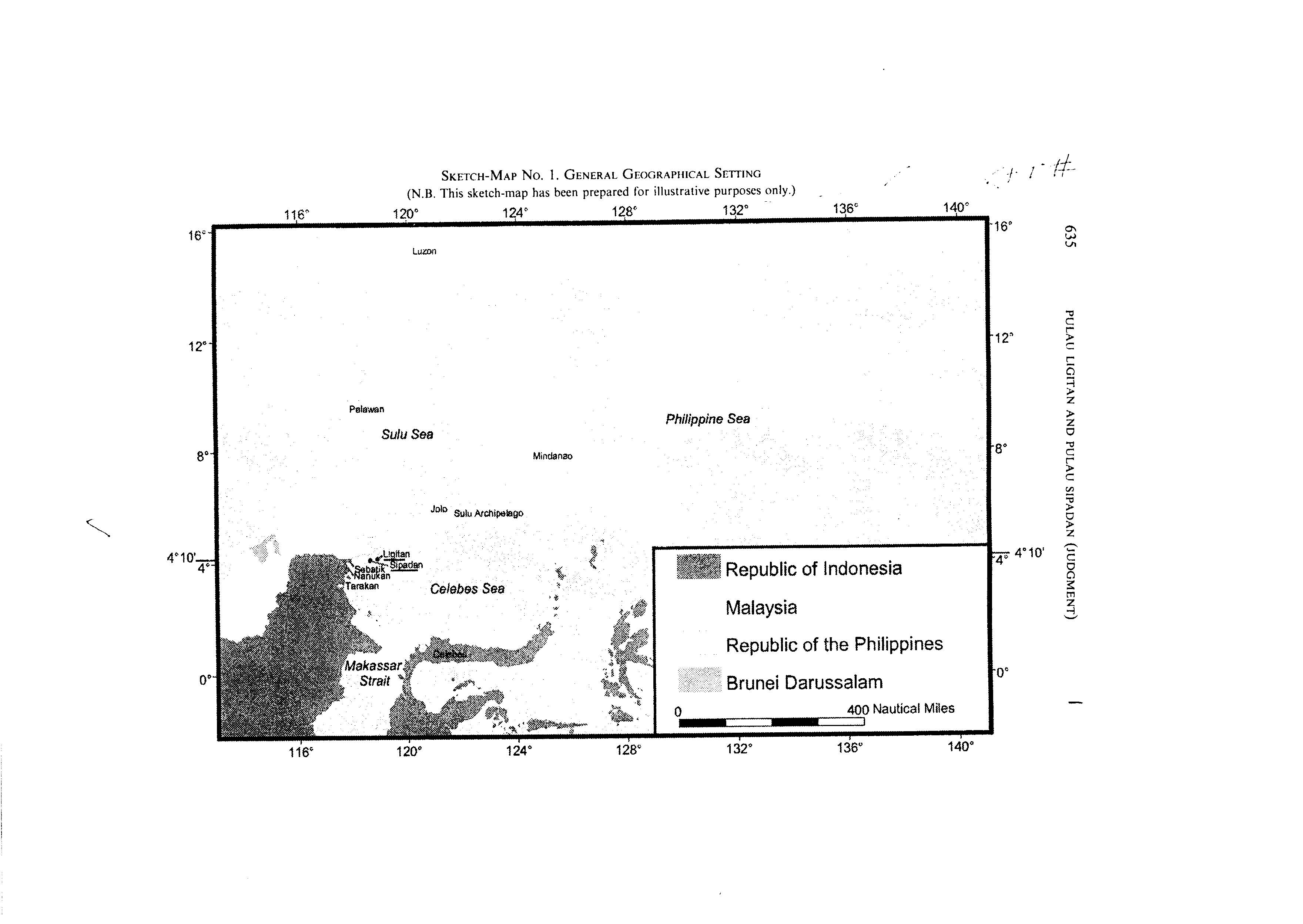
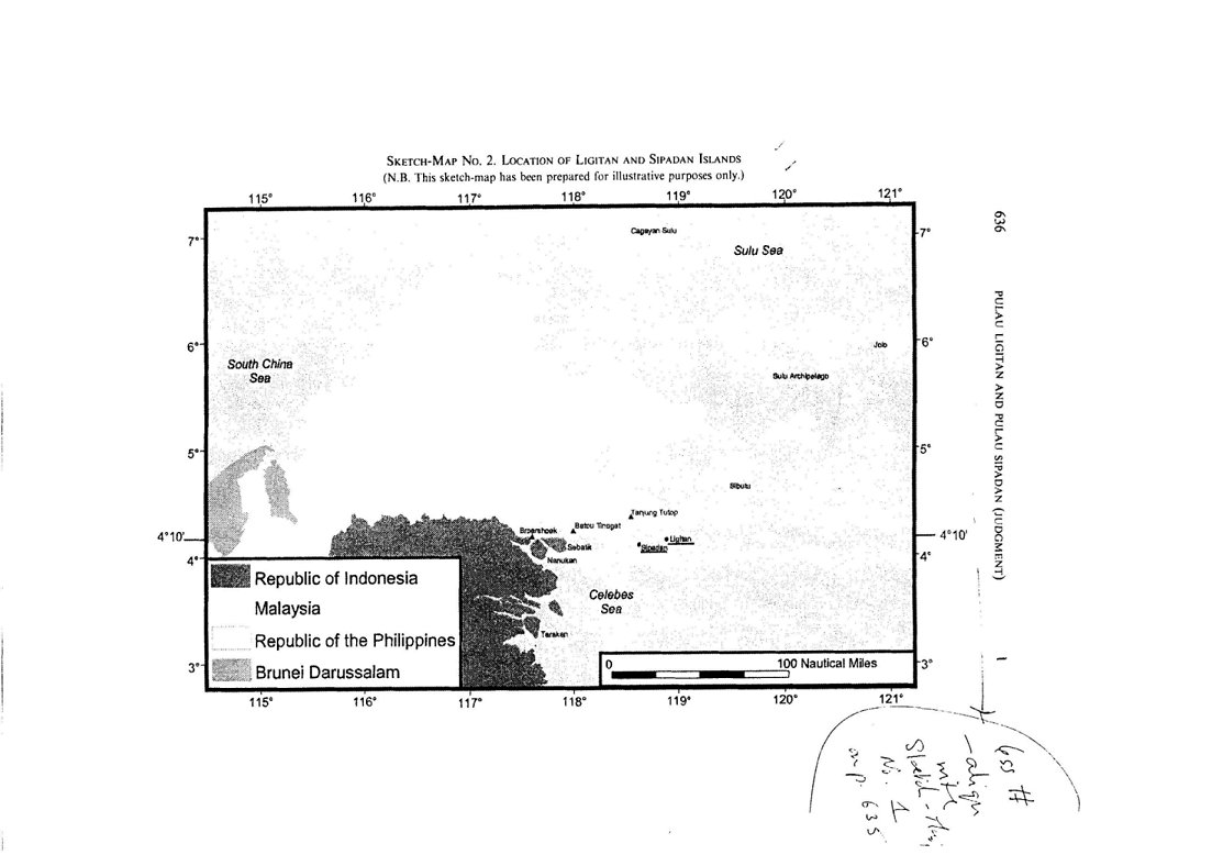