| |
[p303]
THE COURT,
composed as above,
after deliberation,
delivers the following Judgment:
1. On 29 March 1994 the Government of the Republic of Cameroon (hereinafter
referred to as "Cameroon") filed in the Registry of the Court an Application
instituting proceedings against the Government of the Federal Republic of
Nigeria (hereinafter referred to as "Nigeria") concerning a dispute
described as "relating essentially to the question of sovereignty over the
Bakassi Peninsula". Cameroon further stated in its Application that the
"delimitation [of the maritime boundary between the two States] has remained
a partial one and [that], despite many attempts to complete it, the two
parties have been unable to do so". Consequently, it requested the Court,
"in order to avoid further incidents between the two countries, . . . to
determine the course of the maritime boundary between the two States beyond
the line fixed in 1975".
In order to found the jurisdiction of the Court, the Application relied on
the declarations made by the two Parties accepting the jurisdiction of the
Court under Article 36, paragraph 2, of the Statute of the Court.
2. Pursuant to Article 40, paragraph 2, of the Statute, the Application was
immediately communicated to the Government of Nigeria by the Registrar.
3. On 6 June 1994 Cameroon filed in the Registry an Additional Application
"for the purpose of extending the subject of the dispute" to a further
dispute described in that Additional Application as "relating essentially to
the question of sovereignty over a part of the territory of Cameroon in the
area of Lake Chad". Cameroon also requested the Court, in its Additional
Application, "to specify definitively" the frontier between the two States
from Lake Chad to the sea, and asked it to join the two Applications and "to
examine the whole in a single case". In order to found the jurisdiction of
the Court, the Additional Application referred to the "basis of . . .
jurisdiction . . . already . . . indicated" in the Application instituting
proceedings of 29 March 1994.
4. On 7 June 1994 the Registrar communicated the Additional Application to
the Government of Nigeria.
5. At a meeting held by the President of the Court with the representatives
of the Parties on 14 June 1994 the Agent of Cameroon explained that his
Government had not intended to submit a separate Application and that the
Additional Application had instead been designed as an amendment to the
initial Application; the Agent of Nigeria, for his part, declared that his
Government did not object to the Additional Application being treated as an
amendment to the initial Application, so that the Court might examine the
whole in a single case.[p313]
6. By an Order of 16 June 1994 the Court indicated that it had no objection
to such a procedure and fixed 16 March 1995 and 18 December 1995
respectively as the time-limits for the filing of the Memorial of Cameroon
and the Counter-Memorial of Nigeria.
7. Pursuant to Article 40, paragraph 3, of the Statute, all States entitled
to appear before the Court were notified of the Application.
8. Cameroon duly filed its Memorial within the time-limit prescribed for
that purpose.
9. Within the time-limit fixed for the filing of its Counter-Memorial,
Nigeria filed preliminary objections to the jurisdiction of the Court and
the admissibility of the Application. Accordingly, by an Order dated 10
January 1996 the President of the Court, noting that under Article 79,
paragraph 3, of the Rules of Court the proceedings on the merits were
suspended, fixed 15 May 1996 as the time-limit within which Cameroon might
present a written statement of its observations and submissions on the
preliminary objections.
Cameroon duly filed such a statement within the time-limit so prescribed,
and the case became ready for hearing in respect of the preliminary
objections.
10. Since the Court included upon the Bench no judge of the nationality of
the Parties, each Party exercised its right under Article 31, paragraph 3,
of the Statute to choose a judge ad hoc to sit in the case. Cameroon chose
Mr. Keba Mbaye and Nigeria chose Mr. Bola Ajibola.
11. By a letter of 10 February 1996, received in the Registry on 12 February
1996, Cameroon made a request for the indication of provisional measures
under Article 41 of the Statute. By an Order dated 15 March 1996 the Court,
after hearing the Parties, indicated certain provisional measures.
12. The Court held hearings on the preliminary objections raised by Nigeria
from 2 to 11 March 1998. In its Judgment of 11 June 1998 the Court found
that it had jurisdiction to adjudicate upon the merits of the dispute and
that Cameroon's requests were admissible. The Court rejected seven of the
preliminary objections raised by Nigeria and declared that the eighth did
not have an exclusively preliminary character, and that it would rule on it
in the Judgment to be rendered on the merits.
13. By an Order of 30 June 1998 the Court fixed 31 March 1999 as the new
time-limit for the filing of Nigeria's Counter-Memorial.
14. On 28 October 1998 Nigeria submitted a request for interpretation of the
Judgment delivered by the Court on 11 June 1998 on the preliminary
objections; that request became a new case, separate from the present
proceedings. By Judgment dated 25 March 1999 the Court decided that
Nigeria's request for interpretation was inadmissible.
15. On 16 November 1998 the Government of the Republic of Equatorial Guinea
(hereinafter "Equatorial Guinea") requested a copy of the Memorial filed by
Cameroon and of the maps produced to the Court by the Parties at the oral
proceedings on the preliminary objections. The Parties were consulted in
accordance with Article 53, paragraph 1, of the Rules of Court and informed
the Court that they did not object to the communication to the Government of
Equatorial Guinea of the documents requested by it. The documents in
question were transmitted to Equatorial Guinea on 8 December 1998.
16. By an Order of 3 March 1999 the Court extended to 31 May 1999 the
time-limit for the filing of the Counter-Memorial.[p314]
Nigeria duly filed its Counter-Memorial within the time-limit as thus
extended. That pleading included counter-claims.
17. At a meeting held by the President of the Court with the Agents of the
Parties on 28 June 1999 Cameroon indicated that it did not object to
Nigeria's submission of the counter-claims set out in the Counter-Memorial,
and the Parties agreed that a Reply and a Rejoinder were necessary in this
case.
By an Order of 30 June 1999 the Court declared Nigeria's counter-claims
admissible, decided that Cameroon should submit a Reply and Nigeria a
Rejoinder and fixed 4 April 2000 and 4 January 2001 respectively as the
time-limits for the filing of these two pleadings. In its Order the Court
also reserved the right of Cameroon to present its views in writing a second
time on the Nigerian counter-claims in an additional pleading which might be
the subject of a subsequent Order.
The Reply and the Rejoinder were duly filed within the time-limits so fixed.
18. On 30 June 1999 the Republic of Equatorial Guinea filed in the Registry
an Application for permission to intervene in the case pursuant to Article
62 of the Statute. According to that Application, the object of the
intervention sought was to "protect the legal rights of the Republic of
Equatorial Guinea in the Gulf of Guinea by all legal means available" and to
"inform the Court of the nature of the legal rights and interests of
Equatorial Guinea that could be affected by the Court's decision in the
light of the maritime boundary claims advanced by the parties to the case
before the Court". In its Application Equatorial Guinea further indicated
that it "d[id] not seek to become a party to the case".
In accordance with the provisions of Article 83 of the Rules of Court, the
Application for permission to intervene by Equatorial Guinea was immediately
communicated to Cameroon and to Nigeria, and the Court fixed 16 August 1999
as the time-limit for the filing of written observations by those States.
Each of the two States filed its observations within the time-limit so
fixed, and those observations were transmitted to the opposing Party and to
Equatorial Guinea. On 3 September 1999 the Agent of Equatorial Guinea
informed the Court of the views of his Government on the observations made
by the Parties; Equatorial Guinea noted that neither of the two Parties had
objected in principle to the intervention, and it expressed the view that
hearings were not necessary to decide whether the Application for permission
to intervene should be granted.
By an Order of 21 October 1999 the Court, considering that Equatorial Guinea
had sufficiently established that it had an interest of a legal nature which
could be affected by any judgment which the Court might hand down for the
purpose of determining the maritime boundary between Cameroon and Nigeria,
authorized it to intervene in the case to the extent, in the manner and for
the purposes set out in its Application. The Court further fixed the
following time-limits for the filing of the written statement and the
written observations referred to in Article 85, paragraph 1, of the Rules of
Court: 4 April 2001 for the written statement of Equatorial Guinea and 4
July 2001 for the written observations of Cameroon and of Nigeria on that
statement.
The written statement of Equatorial Guinea and the written observations of
the Parties were duly filed within the time-limits so fixed.
19. By a letter of 24 January 2001 the Agent of Cameroon, referring to the
[p315] above-mentioned Order of 30 June 1999, informed the Court that his
Government wished to present its views in writing a second time on Nigeria's
counter-claims and suggested that 4 July 2001 be fixed as the time-limit for
the filing of that additional pleading. The Agent of Nigeria indicated in a
letter of 6 February 2001 that his Government had no objection to that
request. By an Order of 20 February 2001 the Court authorized the
presentation by Cameroon of an additional pleading relating exclusively to
the counter-claims submitted by Nigeria and fixed 4 July 2001 as the
time-limit for the filing of that pleading.
Cameroon duly filed the additional pleading within the time-limit so fixed,
and the case became ready for hearing.
20. At a meeting held by the President of the Court with the Agents of the
Parties and of Equatorial Guinea on 12 September 2001 the three States
expressed heir agreement that the oral proceedings on the merits should open
early in 2002; they also presented their views on the organization of those
proceedings. The Court fixed 18 February 2002 as the date for the opening of
the oral proceedings and adopted the schedule for them. By letters dated 24
September 2001 the Registrar informed the Parties and Equatorial Guinea of
that decision.
21. By a letter of 8 January 2002 Cameroon informed the Court that it wished
to be given the opportunity to reply orally, even if only briefly, to any
observations Nigeria might make during its last round of oral arguments
relating to the counter-claims it had submitted. Nigeria was duly informed
of that request, which the Court decided to grant, the Agents of the Parties
being so informed by letters from the Registrar dated 7 February 2002.
22. By a letter of 11 January 2002 Cameroon expressed the desire to produce
further documents in accordance with Article 56 of the Rules of Court. As
provided in paragraph 1 of that Article, those documents were communicated
to Nigeria. By a letter of 29 January 2002 the Co-Agent of Nigeria informed
the Court that his Government objected to the production of those new
documents, on the grounds, inter alia, that Cameroon had not explained why
the documents, although described as being "of great importance", "[had] not
[been] submitted to the Court at the appropriate time, and in any event
prior to the closure of the written procedure". That letter was communicated
to the Agent of Cameroon, who, by a letter of 1 February 2002, explained
inter alia that in the light of the argument developed in Nigeria's
Rejoinder his Government had "found that a number of documents whose
production it had not judged indispensable at the time of its Reply turned
out to be more important than previously thought". The Court decided not to
authorize the production of the documents, with the exception of those
relating to events subsequent to Cameroon's Reply. The Court also decided to
authorize Nigeria, if it so desired, to file documents in reply to the new
documents produced by Cameroon and to present any observations on them
during the oral proceedings. The Agents of the Parties were so informed by
letters from the Registrar dated 7 February 2002.
23. Pursuant to Article 53, paragraph 2, of its Rules, the Court, after
ascertaining the views of the Parties, decided that copies of the pleadings
and documents annexed would be made available to the public at the opening
of the oral proceedings. After consulting the Parties and Equatorial Guinea,
the Court decided that the same should apply to the written statement of the
intervening [p316]State and the written observations of the two Parties on
that statement.
24. Public hearings were held from 18 February to 21 March 2002, at which
the Court heard the oral arguments and replies of:
For Cameroon: H.E. Mr. Amadou Ali,
Mr. Maurice Kamto,
Mr. Alain Pellet,
Mr. Peter Y. Ntamark,
Mr. Malcolm N. Shaw,
Mr. Bruno Simma,
Mr. Jean-Pierre Cot,
Mr. Daniel Khan,
Mr. Joseph-Marie Bipoun Woum,
Mr. Michel Aurillac,
Mr. Christian Tomuschat,
Mr. Maurice Mendelson,
Mr. Jean-Marc Thouvenin,
Mr. Olivier Corten,
Sir Ian Sinclair.
For Nigeria: H.E. the Honourable Musa E. Abdullahi,
Mrs. Nella Andem-Ewa,
Sir Arthur Watts,
Mr. Ian Brownlie,
Mr. Georges Abi-Saab,
Alhaji Abdullahi Ibrahim,
Mr. Alastair Macdonald,
Mr. James Crawford,
Mr. Richard Akinjide.
For Equatorial Guinea: H.E. Mr. Ricardo Mangue Obama N' Fube,
Mr. David A. Colson,
Mr. Pierre-Marie Dupuy.
At the hearings questions were put by Members of the Court, to which replies
were given orally and in writing. Each Party submitted its written comments,
in accordance with Article 72 of the Rules of Court, on the other's written
replies.
*
25. In its Application, Cameroon made the following requests:
"On the basis of the foregoing statement of facts and legal grounds, the
Republic of Cameroon, while reserving for itself the right to complement,
amend or modify the present Application in the course of the proceedings and
to submit to the Court a request for the indication of provisional measures
should they prove to be necessary, asks the Court to adjudge and declare:
(a) that sovereignty over the Peninsula of Bakassi is Cameroonian, by virtue
of international law, and that that Peninsula is an integral part of the
territory of Cameroon;
(b) that the Federal Republic of Nigeria has violated and is violating the
[p317] fundamental principle of respect for frontiers inherited from
colonization (uti possidetis juris);
(c) that by using force against the Republic of Cameroon, the Federal
Republic of Nigeria has violated and is violating its obligations under
international treaty law and customary law;
(d) that the Federal Republic of Nigeria, by militarily occupying the
Cameroonian Peninsula of Bakassi, has violated and is violating the
obligations incumbent upon it by virtue of treaty law and customary law;
(e) that in view of these breaches of legal obligation, mentioned above, the
Federal Republic of Nigeria has the express duty of putting an end to its
military presence in Cameroonian territory, and effecting an immediate and
unconditional withdrawal of its troops from the Cameroonian Peninsula of
Bakassi;
(e') that the internationally unlawful acts referred to under (a), (b), (c),
(d) and (e) above involve the responsibility of the Federal Republic of
Nigeria;
(e") that, consequently, and on account of the material and non-material
damage inflicted upon the Republic of Cameroon, reparation in an amount to
be determined by the Court is due from the Federal Republic of Nigeria to
the Republic of Cameroon, which reserves the introduction before the Court
of [proceedings for] a precise assessment of the damage caused by the
Federal Republic of Nigeria.
(f) In order to prevent any dispute arising between the two States
concerning their maritime boundary, the Republic of Cameroon requests the
Court to proceed to prolong the course of its maritime boundary with the
Federal Republic of Nigeria up to the limit of the maritime zones which
international law places under their respective jurisdictions."
In its Additional Application, Cameroon made the following requests:
"On the basis of the foregoing statement of facts and legal grounds, and
subject to the reservations expressed in paragraph 20 of its Application of
29 March 1994, the Republic of Cameroon asks the Court to adjudge and
declare:
(a) that sovereignty over the disputed parcel in the area of Lake Chad is
Cameroonian, by virtue of international law, and that that parcel is an
integral part of the territory of Cameroon;
(b) that the Federal Republic of Nigeria has violated and is violating the
fundamental principle of respect for frontiers inherited from colonization
(uti possidetis juris), and its recent legal commitments concerning the
demarcation of frontiers in Lake Chad;
(c) that the Federal Republic of Nigeria, by occupying, with the support of
its security forces, parcels of Cameroonian territory in the area of Lake
Chad, has violated and is violating its obligations under treaty law and
customary law;
(d) that in view of these legal obligations, mentioned above, the Federal
Republic of Nigeria has the express duty of effecting an immediate and
unconditional withdrawal of its troops from Cameroonian territory in the
area of Lake Chad;
(e) that the internationally unlawful acts referred to under (a), (b), (c)
[p318] and (d) above involve the responsibility of the Federal Republic of
Nigeria;
(e') that consequently, and on account of the material and non-material
damage inflicted upon the Republic of Cameroon, reparation in an amount to
be determined by the Court is due from the Federal Republic of Nigeria to
the Republic of Cameroon, which reserves the introduction before the Court
of [proceedings for] a precise assessment of the damage caused by the
Federal Republic of Nigeria.
(f) That in view of the repeated incursions of Nigerian groups and armed
forces into Cameroonian territory, all along the frontier between the two
countries, the consequent grave and repeated incidents, and the vacillating
and contradictory attitude of the Federal Republic of Nigeria in regard to
the legal instruments defining the frontier between the two countries and
the exact course of that frontier, the Republic of Cameroon respectfully
asks the Court to specify definitively the frontier between Cameroon and the
Federal Republic of Nigeria from Lake Chad to the sea."
26. In the course of the written proceedings the following submissions were
presented by the Parties:
On behalf of the Government of Cameroon,
in the Memorial:
"The Republic of Cameroon has the honour to request that the Court be
pleased to adjudge and declare:
(a) That the lake and land boundary between Cameroon and Nigeria takes the
following course:
-- from the point at longitude 14 [degree] 04' 59"9999 E of Greenwich and
latitude 13 [degree] 05' 00"0001 N, it then runs through the point located
at longitude 14 [degree] 12' 11"7 E and latitude 12 [degree] 32' 17"4 N;
-- thence it follows the course fixed by the Franco-British Declaration of
10 July 1919, as specified in paragraphs 3 to 60 of the Thomson/Marchand
Declaration, confirmed by the Exchange of Letters of 9 January 1931, as far
as the 'very prominent peak' described in the latter provision and called by
the usual name of 'Mount Kombon' ;
-- from Mount Kombon the boundary then runs to 'Pillar 64' mentioned in
paragraph 12 of the Anglo-German Agreement of Obokum of 12 April 1913 and
follows, in that sector, the course described in Section 6 (1) of the
British Nigeria (Protectorate and Cameroons) Order in Council of 2 August
1946;
-- from Pillar 64 it follows the course described in paragraphs 13 to 21 of
the Obokum Agreement of 12 April 1913 as far as Pillar 114 on the Cross
River;
-- thence, as far as the intersection of the straight line joining Bakassi
Point to King Point and the centre of the navigable channel of the Akwayafe,
the boundary is determined by paragraphs 16 to 21 of the Anglo-German
Agreement of 11 March 1913.
(b) That in consequence, inter alia, sovereignty over the Peninsula of
Bakassi and over the disputed parcel occupied by Nigeria in the [p319] area
of Lake Chad, in particular over Darak and its region, is Cameroonian.
(c) That the boundary of the maritime zones appertaining respectively to the
Republic of Cameroon and to the Federal Republic of Nigeria follows the
following course:
-- from the intersection of the straight line joining Bakassi Point to King
Point and the centre of the navigable channel of the Akwayafe to 'point 12',
that boundary is determined by the 'compromise line' entered on British
Admiralty Chart No. 3343 by the Heads of State of the two countries on 4
April 1971 (Yaounde Declaration) and, from that 'point 12' to 'point G', by
the Declaration signed at Maroua on 1 June 1975;
-- from point G that boundary then swings south-westward in the direction
which is indicated by points G, H, I, J and K represented on the sketch-map
on page 556 of this Memorial and meets the requirement for an equitable
solution, up to the outer limit of the maritime zones which international
law places under the respective jurisdictions of the two Parties.
(d) That by contesting the courses of the boundary defined above under (a)
and (c), the Federal Republic of Nigeria has violated and is violating the
fundamental principle of respect for frontiers inherited from colonization
(uti possidetis juris) and its legal commitments concerning the demarcation
of frontiers in Lake Chad and land and maritime delimitation.
(e) That by using force against the Republic of Cameroon and, in particular,
by militarily occupying parcels of Cameroonian territory in the area of Lake
Chad and the Cameroonian Peninsula of Bakassi, and by making repeated
incursions, both civilian and military, all along the boundary between the
two countries, the Federal Republic of Nigeria has violated and is violating
its obligations under international treaty law and customary law.
(f) That the Federal Republic of Nigeria has the express duty of putting an
end to its civilian and military presence in Cameroonian territory and, in
particular, of effecting an immediate and unconditional withdrawal of its
troops from the occupied area of Lake Chad and from the Cameroonian
Peninsula of Bakassi and of refraining from such acts in the future;
(g) That the internationally wrongful acts referred to above and described
in detail in the body of this Memorial involve the responsibility of the
Federal Republic of Nigeria.
(h) That, consequently, and on account of the material and non-material
damage inflicted upon the Republic of Cameroon, reparation in a form to be
determined by the Court is due from the Federal Republic of Nigeria to the
Republic of Cameroon.
The Republic of Cameroon further has the honour to request the Court to
permit it to present an assessment of the amount of compensation due to it
as reparation for the damage it has suffered as a result of the
internationally wrongful acts attributable to the Federal Republic of
Nigeria, at a subsequent stage of the proceedings.
These submissions are lodged subject to any points of fact and law and any
evidence that may subsequently be lodged; the Republic of Cameroon [p320]
reserves the right to complete or amend them, as necessary, in accordance
with the Statute and the Rules of Court."
in the Reply:
"The Republic of Cameroon has the honour to request that the Court be
pleased to adjudge and declare:
(a) That the land boundary between Cameroon and Nigeria takes the following
course:
-- from the point at longitude 14 [degree] 04' 59"9999 east of Greenwich and
latitude 13 [degree] 05' 00"0001 north, it then runs through the point
located at longitude 14 [degree] 12' 11"7005 east and latitude 12 [degree]
32' 17"4013 north, in accordance with the Franco-British Declaration of 10
July 1919 and the Thomson-Marchand Declaration of 29 December 1929 and 31
January 1930, confirmed by the Exchange of Letters of 9 January 1931;
-- thence it follows the course fixed by these instruments as far as the
'very prominent peak' described in paragraph 60 of the Thomson-Marchand
Declaration and called by the usual name of 'Mount Kombon';
-- from 'Mount Kombon' the boundary then runs to 'Pillar 64' mentioned in
paragraph 12 of the Anglo-German Agreement of Obokum of 12 April 1913 and
follows, in that sector, the course described in Section 6 (1) of the
British Nigeria (Protectorate and Cameroons) Order in Council of 2 August
1946;
-- from Pillar 64 it follows the course described in paragraphs 13 to 21 of
the Obokum Agreement of 12 April 1913 as far as Pillar 114 on the Cross
River;
-- thence, as far as the intersection of the straight line joining Bakassi
Point to King Point and the centre of the navigable channel of the Akwayafe,
the boundary is determined by paragraphs 16 to 21 of the Anglo-German
Agreement of 11 March 1913.
(b) That, in consequence, inter alia, sovereignty over the Peninsula of
Bakassi and over the disputed parcel occupied by Nigeria in the area of Lake
Chad, in particular over Darak and its region, is Cameroonian.
(c) That the boundary of the maritime zones appertaining respectively to the
Republic of Cameroon and to the Federal Republic of Nigeria follows the
following course:
-- from the intersection of the straight line joining Bakassi Point to King
Point and the centre of the navigable channel of the Akwayafe to 'point 12',
that boundary is determined by the 'compromise line' entered on British
Admiralty Chart No. 3433 by the Heads of State of the two countries on 4
April 1971 (Yaounde Declaration) and, from that 'point 12' to 'point G', by
the Declaration signed at Maroua on 1 June 1975;
-- from point G that boundary then swings south-westward in the direction
which is indicated by Points G, H with co-ordinates 8 [degree] 21' 16" east
and 4 [degree] 17' 00" north, I (7 [degree] 55' 40" east and 3 [degree] 46'
00" north), J (7 [degree] 12' 08" east and 3 [degree] 12' 35" north) and K
(6 [degree] 45' 22" east and 3 [degree] 01' 05" north), represented on the
sketch-map R21 on [p321] page 411 of this Reply and which meets the
requirement for an equitable solution, up to the outer limit of the maritime
zones which international law places under the respective jurisdictions of
the two Parties.
(d) That in attempting to modify unilaterally and by force the courses of
the boundary defined
above under (a) and (c), the Federal Republic of Nigeria has violated and is
violating the fundamental principle of respect for frontiers inherited from
colonization (uti possidetis juris) and its legal commitments concerning
land and maritime delimitation.
(e) That by using force against the Republic of Cameroon and, in particular,
by militarily occupying parcels of Cameroonian territory in the area of Lake
Chad and the Cameroonian Peninsula of Bakassi, and by making repeated
incursions, both civilian and military, all along the boundary between the
two countries, the Federal Republic of Nigeria has violated and is violating
its obligations under international treaty law and customary law.
(f) That the Federal Republic of Nigeria has the express duty of putting an
end to its civilian and military presence in Cameroonian territory and, in
particular, of effecting an immediate and unconditional withdrawal of its
troops from the occupied area of Lake Chad and from the Cameroonian
Peninsula of Bakassi and of refraining from such acts in the future.
(g) That the internationally wrongful acts referred to above and described
in detail in the Memorial of the Republic of Cameroon and in the present
Reply engage the responsibility of the Federal Republic of Nigeria.
(h) That, consequently, and on account of the material and non-material
damage inflicted upon the Republic of Cameroon, reparation in a form to be
determined by the Court is due from the Federal Republic of Nigeria to the
Republic of Cameroon.
The Republic of Cameroon further has the honour to request the Court to
permit it to present an assessment of the amount of compensation due to it
as reparation for the damage it has suffered as a result of the
internationally wrongful acts attributable to the Federal Republic of
Nigeria, at a subsequent stage of the proceedings.
The Republic of Cameroon also asks the Court to declare that the
counter-claims of the Federal Republic of Nigeria are unfounded both in fact
and in law, and to reject them.
These submissions are lodged subject to any points of fact and law and any
evidence that may subsequently be lodged; the Republic of Cameroon reserves
the right to supplement or amend them, as necessary, in accordance with the
Statute and the Rules of Court."
in the additional pleading entitled "Observations of Cameroon by Way of
Rejoinder":
"The Republic of Cameroon has the honour to request that it may please the
International Court of Justice to adjudge and declare that the
counter-claims of the Federal Republic of Nigeria, which appear to be
inadmissible in light of the arguments put forward in the Rejoinder, in any
event have no basis in fact or in law, and to reject them."[p322]
On behalf of the Government of Nigeria,
in the Counter-Memorial:
"For the reasons given herein, the Federal Republic of Nigeria, reserving
the right to amend and modify these submissions in the light of the further
pleadings in this case, respectfully requests that the Court should:
(1) as a preliminary matter decide to deal with the issues relating to the
land boundary;
(2) as to Lake Chad, adjudge and declare:
-- that sovereignty over the areas in Lake Chad defined in Chapter 14 of
this Counter-Memorial (including the Nigerian settlements identified in
paragraph 14.5 hereof) is vested in the Federal Republic of Nigeria;
-- that the proposed 'demarcation' under the auspices of the Lake Chad Basin
Commission, not having been ratified by Nigeria, is not binding upon it;
-- that outstanding issues of the delimitation and demarcation within the
area of Lake Chad are to be resolved by the Parties to the Lake Chad Basin
Commission within the framework of the constitution and procedures of the
Commission;
(3) as to the central sectors of the land boundary:
-- acknowledging that the parties recognise that the boundary between the
mouth of the Ebeji River and the point on the thalweg of the Akpa Yafe which
is opposite the mid-point of the mouth of Archibong Creek is delimited by
the following instruments:
(a) paragraphs 3-60 of the Thomson/Marchand Declaration, confirmed by the
Exchange of Letters of 9 January 1931,
(b) the Nigeria (Protectorate and Cameroons) Order in Council of 2 August
1946, section 6(1) and the Second Schedule thereto,
(c) paragraphs 13-21 of the Anglo-German Demarcation Agreement of 12 April
1913,
(d) Articles XV-XVII of the Anglo-German Treaty of 11 March 1913; and
-- acknowledging further that uncertainties as to the interpretation and
application of these instruments, and established local agreements in
certain areas, mean that the actual course of the boundary cannot be
definitively specified merely by reference to those instruments;
affirm that the instruments mentioned above are binding on the parties
(unless lawfully varied by them) as to the course of the land boundary;
(4) as to the Bakassi Peninsula, adjudge and declare:
-- that sovereignty over the Peninsula (as defined in Chapter 11 hereof) is
vested in the Federal Republic of Nigeria;
(5) as to the maritime boundary, adjudge and declare:
(a) that the Court lacks jurisdiction to deal with Cameroon's claim-line, to
the extent that it impinges on areas claimed by Equatorial [p323] Guinea
and/or Sao Tome e Principe (which areas are provisionally identified in
Figure 20.3 herein), or alternatively that Cameroon's claim is inadmissible
to that extent; and
(b) that the parties are under an obligation, pursuant to Articles 76 and 83
of the United Nations Law of the Sea Convention, to negotiate in good faith
with a view to agreeing on an equitable delimitation of their respective
maritime zones, such delimitation to take into account, in particular, the
need to respect existing rights to explore and exploit the mineral resources
of the continental shelf, granted by either party prior to 29 March 1994
without written protest from the other, and the need to respect the
reasonable maritime claims of third States;
(6) as to Cameroon's claims of State responsibility, adjudge and declare
that those claims are unfounded in fact and law; and
(7) as to Nigeria's counter-claims as specified in Part VI of this
Counter-Memorial, adjudge and declare that Cameroon bears responsibility to
Nigeria in respect of those claims, the amount of reparation due therefor,
if not agreed between the parties within six months of the date of judgment,
to be determined by the Court in a further judgment."
in the Rejoinder:
"For the reasons given herein, the Federal Republic of Nigeria, reserving
the right to amend and modify these submissions in the light of any further
pleadings in this case, respectfully requests that the Court should:
(1) as to the Bakassi Peninsula, adjudge and declare:
(a) that sovereignty over the Peninsula is vested in the Federal Republic of
Nigeria;
(b) that Nigeria's sovereignty over Bakassi extends up to the boundary with
Cameroon described in Chapter 11 of Nigeria's Counter-Memorial;
(2) as to Lake Chad, adjudge and declare:
(a) that the proposed 'demarcation' under the auspices of the Lake Chad
Basin Commission, not having been ratified by Nigeria, is not binding upon
it;
(b) that sovereignty over the areas in Lake Chad defined in paragraph 5.9 of
this Rejoinder and depicted in Figs. 5.2 and 5.3 facing page 242 (and
including the Nigerian settlements identified in paragraph 4.1 of this
Rejoinder) is vested in the Federal Republic of Nigeria;
(c) that outstanding issues of the delimitation and demarcation within the
area of Lake Chad are to be resolved by the Parties to the Lake Chad Basin
Commission within the framework of the constitution and procedures of the
Commission;
(d) that in any event, the operation intended to lead to an overall
delimitation of boundaries on Lake Chad is legally without preju-[p324]dice
to the title to particular areas of the Lake Chad region inhering in Nigeria
as a consequence of the historical consolidation of title and the
acquiescence of Cameroon;
(3) as to the central sectors of the land boundary, adjudge and declare:
(a) that the Court's jurisdiction extends to the definitive specification of
the land boundary between Lake Chad and the sea;
(b) that the mouth of the Ebeji, marking the beginning of the land boundary,
is located at the point where the north-east channel of the Ebeji flows into
the feature marked 'Pond' on the Map shown as Fig. 7.1 of this Rejoinder,
which location is at latitude 12 [degree] 31' 45" N, longitude 14 [degree]
13' 00" E (Adindan Datum);
(c) that subject to the clarifications, interpretations and variations
explained in Chapter 7 of this Rejoinder, the land boundary between the
mouth of the Ebeji and the point on the thalweg of the Akpa Yafe which is
opposite the mid-point of the mouth of Archibong Creek is delimited by the
terms of:
(i) paragraphs 2-61 of the Thomson-Marchand Declaration, confirmed by the
Exchange of Letters of 9 January 1931;
(ii) the Nigeria (Protectorate and Cameroons) Order in Council of 2 August
1946, section 6(1) and the Second Schedule thereto;
(iii) paragraphs 13-21 of the Anglo-German Demarcation Agreement of 12 April
1913; and
(iv) Articles XV to XVII of the Anglo-German Treaty of 11 March 1913;
(d) that the effect of the first two of those instruments, as clarified,
interpreted or varied in the manner identified by Nigeria, is as set out in
the Appendix to Chapter 8 and delineated in the maps in the Atlas submitted
with this Rejoinder;
(4) as to the maritime boundary, adjudge and declare:
(a) that the Court lacks jurisdiction over Cameroon's maritime claim from
the point at which its claim line enters waters claimed by or recognised by
Nigeria as belonging to Equatorial Guinea, or alternatively that Cameroon's
claim is inadmissible to that extent;
(b) that Cameroon's claim to a maritime boundary based on the global
division of maritime zones in the Gulf of Guinea is inadmissible, and that
the parties are under an obligation, pursuant to Articles 74 and 83 of the
United Nations Law of the Sea Convention, to negotiate in good faith with a
view to agreeing on an equitable delimitation of their respective maritime
zones, such delimitation to take into account, in particular, the need to
respect existing rights to explore and exploit the mineral resources of the
continental shelf, granted by either party prior to 29 March 1994 without
written protest from the other, and the need to respect the reasonable
maritime claims of third States;[p323]
(c) in the alternative, that Cameroon's claim to a maritime boundary based
on the global division of maritime zones in the Gulf of Guinea is unfounded
in law and is rejected;
(d) that, to the extent that Cameroon's claim to a maritime boundary may be
held admissible in the present proceedings, Cameroon's claim to a maritime
boundary to the west and south of the area of overlapping licences, as shown
on Fig. 10.2 of this Rejoinder, is rejected;
(e) that the respective territorial waters of the two States are divided by
a median line boundary within the Rio del Rey;
(f) that, beyond the Rio del Rey, the respective maritime zones of the
parties are to be delimited in accordance with the principle of
equidistance, to the point where the line so drawn meets the median line
boundary with Equatorial Guinea at approximately 4 [degree] 6' N, 8 [degree]
30' E;
(5) as to Cameroon's claims of State responsibility, adjudge and declare:
that, to the extent to which any such claims are still maintained by
Cameroon, and are admissible, those claims are unfounded in fact and law;
and
(6) as to Nigeria's counter-claims, as specified in Part VI of the
Counter-Memorial and in Chapter 18 of this Rejoinder, adjudge and declare:
that Cameroon bears responsibility to Nigeria in respect of each of those
claims, the amount of reparation due therefor, if not agreed between the
parties within six months of the date of judgment, to be determined by the
Court in a further judgment."
27. At the oral proceedings, the following submissions were presented by the
Parties: On behalf of the Government of Cameroon,
"Pursuant to the provisions of Article 60, paragraph 2, of the Rules of
Court the Republic of Cameroon has the honour to request that the
International Court of Justice be pleased to adjudge and declare:
(a) That the land boundary between Cameroon and Nigeria takes the following
course:
-- from the point designated by the co-ordinates 13 [degree] 05' north and
14 [degree] 05' east, the boundary follows a straight line as far as the
mouth of the Ebeji, situated at the point located at the co-ordinates 12
[degree] 32' 17" north and 14 [degree] 12' 12" east, as defined within the
framework of the LCBC and constituting an authoritative interpretation of
the Milner-Simon Declaration of 10 July 1919 and the Thomson-Marchand
Declarations of 29 December 1929 and 31 January 1930, as confirmed by the
Exchange of Letters of 9 January 1931; in the alternative, the mouth of the
Ebeji is situated at the point located at the co-ordinates 12 [degree] 31'
12" north and 14 [degree] 11' 48" east;
-- from that point it follows the course fixed by those instruments as [p326] far as the 'very prominent peak' described in paragraph 60 of the
Thomson-Marchand Declaration and called by the usual name of 'Mount Kombon';
-- from 'Mount Kombon' the boundary then runs to 'Pillar 64' mentioned in
paragraph 12 of the Anglo-German Agreement of Obokum of 12 April 1913 and
follows, in that sector, the course described in Section 6 (1) of the
British Nigeria (Protectorate and Cameroons) Order in Council of 2 August
1946;
-- from Pillar 64 it follows the course described in paragraphs 13 to 21 of
the Obokum Agreement of 12 April 1913 as far as Pillar 114 on the Cross
River;
-- thence, as far as the intersection of the straight line from Bakassi
Point to King Point with the centre of the navigable channel of the
Akwayafe, the boundary is determined by paragraphs XVI to XXI of the
Anglo-German Agreement of 11 March 1913.
(b) That in consequence, inter alia, sovereignty over the peninsula of
Bakassi and over the disputed parcel occupied by Nigeria in the area of Lake
Chad, in particular over Darak and its region, is Cameroonian.
(c) That the boundary of the maritime areas appertaining respectively to the
Republic of Cameroon and to the Federal Republic of Nigeria takes the
following course:
-- from the intersection of the straight line from Bakassi Point to King
Point with the centre of the navigable channel of the Akwayafe to point
'12', that boundary is confirmed by the 'compromise line' entered on British
Admiralty Chart No. 3433 by the Heads of State of the two countries on 4
April 1971 (Yaounde II Declaration) and, from that point 12 to point 'G', by
the Declaration signed at Maroua on 1 June 1975;
-- from point G the equitable line follows the direction indicated by points
G, H (co-ordinates 8 [degree] 21' 16" east and 4 [degree] 17' north), I (7
[degree] 55' 40" east and 3 [degree] 46' north), J (7 [degree] 12' 08" east
and 3 [degree] 12' 35" north), K (6 [degree] 45' 22" east and 3 [degree] 01'
05" north), and continues from K up to the outer limit of the maritime zones
which international law places under the respective jurisdiction of the two
Parties.
(d) That in attempting to modify unilaterally and by force the courses of
the boundary defined above under (a) and (c), the Federal Republic of
Nigeria has violated and is violating the fundamental principle of respect
for frontiers inherited from colonization (uti possidetis juris), as well as
its legal obligations concerning the land and maritime delimitation.
(e) That by using force against the Republic of Cameroon and, in particular,
by militarily occupying parcels of Cameroonian territory in the area of Lake
Chad and the Cameroonian peninsula of Bakassi, and by making repeated
incursions throughout the length of the boundary between the two countries,
the Federal Republic of Nigeria has violated and is violating its
obligations under international treaty law and customary law.
(f) That the Federal Republic of Nigeria has the express duty of putting an
end to its administrative and military presence in Cameroonian territory
and, in particular, of effecting an immediate and uncondi-[p327]tional
evacuation of its troops from the occupied area of Lake Chad and from the
Cameroonian peninsula of Bakassi and of refraining from such acts in the
future.
(g) That in failing to comply with the Order for the indication of
provisional measures rendered by the Court on 15 March 1996 the Federal
Republic of Nigeria has been in breach of its international obligations.
(h) That the internationally wrongful acts referred to above and described
in detail in the written pleadings and oral argument of the Republic of
Cameroon engage the responsibility of the Federal Republic of Nigeria.
(i) That, consequently, on account of the material and moral injury suffered
by the Republic of Cameroon reparation in a form to be determined by the
Court is due from the Federal Republic of Nigeria to the Republic of
Cameroon.
The Republic of Cameroon further has the honour to request the Court to
permit it, at a subsequent stage of the proceedings, to present an
assessment of the amount of compensation due to it as reparation for the
injury suffered by it as a result of the internationally wrongful acts
attributable to the Federal Republic of Nigeria.
The Republic of Cameroon also asks the Court to declare that the
counter-claims of the Federal Republic of Nigeria are unfounded both in fact
and in law, and to reject them."
On behalf of the Government of Nigeria,
"The Federal Republic of Nigeria respectfully requests that the Court should
1. as to the Bakassi Peninsula, adjudge and declare:
(a) that sovereignty over the Peninsula is vested in the Federal Republic of
Nigeria;
(b) that Nigeria's sovereignty over Bakassi extends up to the boundary with
Cameroon described in Chapter 11 of Nigeria's Counter-Memorial;
2. as to Lake Chad, adjudge and declare:
(a) that the proposed delimitation and demarcation under the auspices of the
Lake Chad Basin Commission, not having been accepted by Nigeria, is not
binding upon it;
(b) that sovereignty over the areas in Lake Chad defined in paragraph 5.9 of
Nigeria's Rejoinder and depicted in Figs. 5.2 and 5.3 facing page 242 (and
including the Nigerian settlements identified in paragraph 4.1 of Nigeria's
Rejoinder) is vested in the Federal Republic of Nigeria;
(c) that in any event the process which has taken place within the framework
of the Lake Chad Basin Commission, and which was intended to lead to an
overall delimitation and demarcation of boundaries on Lake Chad, is legally
without prejudice to the title to particular areas of the Lake Chad region
inhering in Nigeria as a consequence of the historical consolidation of
title and the acquiescence of Cameroon; [p328]
3. as to the central sectors of the land boundary, adjudge and declare:
(a) that the Court's jurisdiction extends to the definitive specification of
the land boundary between Lake Chad and the sea;
(b) that the mouth of the Ebeji, marking the beginning of the land boundary,
is located at the point where the north-east channel of the Ebeji flows into
the feature marked 'Pond' on the map shown as Fig. 7.1 of Nigeria's
Rejoinder, which location is at latitude 12 [degree] 31' 45" N, longitude 14
[degree] 13' 00" E (Adindan Datum);
(c) that subject to the interpretations proposed in Chapter 7 of Nigeria's
Rejoinder, the land boundary between the mouth of the Ebeji and the point on
the thalweg of the Akpa Yafe which is opposite the midpoint of the mouth of
Archibong Creek is delimited by the terms of the relevant boundary
instruments, namely:
(i) paragraphs 2-61 of the Thomson-Marchand Declaration, confirmed by the
Exchange of Letters of 9 January 1931;
(ii) the Nigeria (Protectorate and Cameroons) Order in Council of 2 August
1946, (Section 6 (1) and the Second Schedule thereto);
(iii) paragraphs 13-21 of the Anglo-German Demarcation Agreement of 12 April
1913;
and
(iv) Articles XV to XVII of the Anglo-German Treaty of 11 March 1913; and
(d) that the interpretations proposed in Chapter 7 of Nigeria's Rejoinder,
and the associated action there identified in respect of each of the
locations where the delimitation in the relevant boundary instruments is
defective or uncertain, are confirmed;
4. as to the maritime boundary, adjudge and declare:
(a) that the Court lacks jurisdiction over Cameroon's maritime claim from
the point at which its claim line enters waters claimed against Cameroon by
Equatorial Guinea, or alternatively that Cameroon's claim is inadmissible to
that extent;
(b) that Cameroon's claim to a maritime boundary based on the global
division of maritime zones in the Gulf of Guinea is inadmissible, and that
the parties are under an obligation, pursuant to Articles 74 and 83 of the
United Nations Law of the Sea Convention, to negotiate in good faith with a
view to agreeing on an equitable delimitation of their respective maritime
zones, such delimitation to take into account, in particular, the need to
respect existing rights to explore and exploit the mineral resources of the
continental shelf, granted by either party prior to 29 March 1994 without
written protest from the other, and the need to respect the reasonable
maritime claims of third States;
(c) in the alternative, that Cameroon's claim to a maritime boundary [p329]
based on the global division of maritime zones in the Gulf of Guinea is
unfounded in law and is rejected;
(d) that, to the extent that Cameroon's claim to a maritime boundary may be
held admissible in the present proceedings, Cameroon's claim to a maritime
boundary to the west and south of the area of overlapping licenses, as shown
in Fig. 10.2 of Nigeria's Rejoinder, is rejected;
(e) that the respective territorial waters of the two States are divided by
a median line boundary within the Rio del Rey;
(f) that, beyond the Rio del Rey, the respective maritime zones of the
parties are to be delimited by a line drawn in accordance with the principle
of equidistance, until the approximate point where that line meets the
median line boundary with Equatorial Guinea, i.e. at approximately 4
[degree] 6' N, 8 [degree] 30' E;
5. as to Cameroon's claims of State responsibility, adjudge and declare:
that, to the extent to which any such claims are still maintained by
Cameroon, and are admissible, those claims are unfounded in fact and law;
and,
6. as to Nigeria's counter-claims as specified in Part VI of Nigeria's
Counter-Memorial and in Chapter 18 of Nigeria's Rejoinder, adjudge and
declare:
that Cameroon bears responsibility to Nigeria in respect of each of those
claims, the amount of reparation due therefor, if not agreed between the
parties within six months of the date of judgment, to be determined by the
Court in a further judgment."
*
28. At the end of the written statement submitted by it in accordance with
Article 85, paragraph 1, of the Rules of Court, Equatorial Guinea stated
inter alia:
"Equatorial Guinea's request is simple and straightforward, founded in the
jurisprudence of the Court, makes good sense in the practice of the
international community and is consistent with the practice of the three
States in the region concerned: its request is that the Court refrain from
delimiting a maritime boundary between Nigeria and Cameroon in any area that
is more proximate to Equatorial Guinea than to the Parties to the case
before the Court. Equatorial Guinea believes it has presented a number of
good reasons for the Court to adopt this position."
29. At the end of the oral observations submitted by it with respect to the
subject-matter of the intervention in accordance with Article 85, paragraph
3, of the Rules of Court, Equatorial Guinea stated inter alia:
"We ask the Court not to delimit a maritime boundary between Cameroon and
Nigeria in areas lying closer to Equatorial Guinea than to the coasts of the
two Parties or to express any opinion which could prejudice our interests in
the context of our maritime boundary negotiations with [p330] our
neighbours . . . Safeguarding the interests of the third State in these
proceedings means that the delimitation between Nigeria and Cameroon decided
by the Court must necessarily remain to the north of the median line between
Equatorial Guinea's Bioko Island and the mainland."
***
30. Cameroon and Nigeria are States situated on the west coast of Africa.
Their land boundary extends from Lake Chad in the north to the Bakassi
Peninsula in the south. Their coastlines are adjacent and are washed by the
waters of the Gulf of Guinea.
Four States border Lake Chad: Cameroon, Chad, Niger and Nigeria. The waters
of the lake have varied greatly over time.
In its northern part, the land boundary between Cameroon and Nigeria passes
through hot dry plains around Lake Chad, at an altitude of about 300 m. It
then passes through mountains, cultivated high ground or pastures, watered
by various rivers and streams. It then descends in stages to areas of
savannah and forest until it reaches the sea.
The coastal region where the southern part of the land boundary ends is the
area of the Bakassi Peninsula. This peninsula, situated in the hollow of the
Gulf of Guinea, is bounded by the River Akwayafe to the west and by the Rio
del Rey to the east. It is an amphibious environment, characterized by an
abundance of water, fish stocks and mangrove vegetation. The Gulf of Guinea,
which is concave in character at the level of the Cameroonian and Nigerian
coastlines, is bounded by other States, in particular by Equatorial Guinea,
whose Bioko Island lies opposite the Parties' coastlines.
**
31. The dispute between the Parties as regards their land boundary falls
within an historical framework marked initially, in the nineteenth and early
twentieth centuries, by the actions of the European Powers with a view to
the partitioning of Africa, followed by changes in the status of the
relevant territories under the League of Nations mandate system, then the
United Nations trusteeships, and finally by the territories' accession to
independence. This history is reflected in a number of conventions and
treaties, diplomatic exchanges, certain administrative instruments, maps of
the period and various documents, which have been provided to the Court by
the Parties.
The delimitation of the Parties' maritime boundary is an issue of more
recent origin, the history of which likewise involves various international
instruments.
32. The Court will now give some particulars of the principal instruments
which are relevant for purposes of determining the course of the [p331]
land and maritime boundary between the Parties. It will later describe in
detail and analyse certain of those instruments.
33. At the end of the nineteenth and the beginning of the twentieth
centuries, various agreements were concluded by Germany, France and Great
Britain to delimit the boundaries of their respective colonial territories.
Thus the boundary between France and Great Britain was defined by the
Convention between those two States Respecting the Delimitation of the
Frontier between the British and French Possessions to the East of the
Niger, signed at London on 29 May 1906 (hereinafter the "Franco-British
Convention of 1906"), as supplemented by a Protocol of the same name dated
19 February 1910 (hereinafter the "Franco-British Protocol of 1910"). The
Franco-German boundary was defined by the Convention between the French
Republic and Germany for the Delimitation of the Colonies of French Congo
and of Cameroon and French and German Spheres of Influence in the Region of
Lake Chad, signed at Berlin on 15 March 1894, and by the Franco-German
Convention Confirming the Protocol of 9 April 1908 Defining the Boundaries
between the French Congo and Cameroon, signed at Berlin on 18 April 1908
(hereinafter the "Franco-German Convention of 1908"). The boundary between
Great Britain and Germany was first defined by the Agreement between Great
Britain and Germany respecting Boundaries in Africa, signed at Berlin on 15
November 1893, and supplemented by a further Agreement of 19 March 1906
respecting the Boundary between British and German Territories from Yola to
Lake Chad (hereinafter the "Anglo-German Agreement of 1906"). The southern
part of the boundary was subsequently redefined by two Agreements concluded
between Great Britain and Germany in 1913. The first of these Agreements,
signed in London on 11 March 1913 (hereinafter, the "Anglo-German Agreement
of 11 March 1913"), concerned "(1) The Settlement of the Frontier between
Nigeria and the Cameroons, from Yola to the Sea and (2) The Regulation of
Navigation on the Cross River" and covered some 1,100 km of boundary; the
second, signed at Obokum on 12 April 1913 by Hans Detzner and W. V. Nugent
representing Germany and Great Britain respectively (hereinafter the
"Anglo-German Agreement of 12 April 1913"), concerned the Demarcation of the
Anglo-German Boundary between Nigeria and the Cameroons from Yola to the
Cross River and included eight accompanying maps.
34. At the end of the First World War, all the territories belonging to
Germany in the region, extending from Lake Chad to the sea, were apportioned
between France and Great Britain by the Treaty of Versailles and then placed
under British or French mandate by agreement with the League of Nations. As
a result it was necessary to define the limits separating the mandated
territories. The first instrument drawn up for this purpose was the
Franco-British Declaration signed on 10 July 1919 by Viscount Milner, the
British Secretary of State for the Colonies, and Henry Simon, the French
Minister for the Colonies (hereinafter the "Milner-Simon Declaration"). With
a view to clarifying this initial instru-[p332]ment, on 29 December 1929
and 31 January 1930 Sir Graeme Thomson, Governor of the Colony and
Protectorate of Nigeria, and Paul Marchand, commissaire de la Republique
francaise au Cameroun, signed a further very detailed agreement (hereinafter
the "Thomson-Marchand Declaration"). This Declaration was approved and
incorporated in an Exchange of Notes dated 9 January 1931 between A. de
Fleuriau, the French Ambassador in London, and Arthur Henderson, the British
Foreign Minister (hereinafter the "Henderson-Fleuriau Exchange of Notes").
35. Following the Second World War, the British and French mandates over the
Cameroons were replaced by United Nations trusteeship agreements. The
trusteeship agreements for the British Cameroons and for the Cameroons under
French administration were both approved by the General Assembly on 13
December 1946. These agreements referred to the line laid down by the
Milner-Simon Declaration to describe the respective territories placed under
the trusteeship of the two European Powers.
Pursuant to a decision taken by Great Britain on 2 August 1946 regarding the
territories then under British mandate, namely the 1946 Order in Council
Providing for the Administration of the Nigeria Protectorate and Cameroons
(hereinafter the "1946 Order in Council"), the regions placed under its
trusteeship were divided into two for administrative purposes, thus giving
birth to the Northern Cameroons and the Southern Cameroons. The 1946 Order
in Council contained a series of provisions describing the line separating
these two regions and provided that they would be administered from Nigeria.
On 1 January 1960 the French Cameroons acceded to independence on the basis
of the boundaries inherited from the previous period. Nigeria did likewise
on 1 October 1960.
In accordance with United Nations directives, the British Government
organized separate plebiscites in the Northern and Southern Cameroons, "in
order to ascertain the wishes of the inhabitants . . . concerning their
future" (General Assembly resolution 1350 (XIII) of 13 March 1959). In those
plebiscites, held on 11 and 12 February 1961, the population of the Northern
Cameroons "decided to achieve independence by joining the independent
Federation of Nigeria", whereas the population of the Southern Cameroons
"decided to achieve independence by joining the independent Republic of
Cameroon" (General Assembly resolution 1608 (XV) of 21 April 1961).
36. As regards the frontier in Lake Chad, on 22 May 1964 the four States
bordering the lake signed a Convention establishing the Lake Chad Basin
Commission (hereinafter the "LCBC"). As the Court recalled in its Judgment
of 11 June 1998 (Land and Maritime Boundary between Cameroon and Nigeria
(Cameroon v. Nigeria), Preliminary Objections, Judgment, I.C.J. Reports
1998, pp. 304-305, paras. 64-65), the functions of the LCBC are laid down in
Article IX of its Statute, as annexed to the [p333] 1964 Convention. Under
the terms of this provision, the LCBC inter alia prepares "general
regulations which will permit the full application of the principles set
forth in the present Convention and its annexed Statute, and [to] ensure
their effective application". It exercises various powers with a view to
co-ordinating action by the member States regarding the use of the waters of
the basin. According to Article IX, paragraph (g), one of its functions is
"to examine complaints and to promote the settlement of disputes". Over the
years the member States of the LCBC have conferred certain additional powers
on it. Thus, following incidents in 1983 among riparian States in the Lake
Chad area, an extraordinary meeting of the LCBC was called from 21 to 23
July 1983 in Lagos (Nigeria), on the initiative of the Heads of State
concerned, in order to give it the task of dealing with certain boundary and
security issues. The LCBC has met regularly since to discuss these issues.
37. The question of the boundary in Bakassi and of sovereignty over the
peninsula also involves specific instruments.
On 10 September 1884 Great Britain and the Kings and Chiefs of Old Calabar
concluded a Treaty of Protection (hereinafter the "1884 Treaty"). Under this
Treaty, Great Britain undertook to extend its protection to these Kings and
Chiefs, who in turn agreed and promised inter alia to refrain from entering
into any agreements or treaties with foreign nations or Powers without the
prior approval of the British Government.
Shortly before the First World War, the British Government concluded two
agreements with Germany, dated respectively 11 March and 12 April 1913 (see
paragraph 33 above), whose objects included "the Settlement of the Frontier
between Nigeria and the Cameroons, from Yola to the Sea" and which placed
the Bakassi Peninsula in German territory.
38. The maritime boundary between Cameroon and Nigeria was not the subject
of negotiations until relatively recently. Thus, apart from the Anglo-German
Agreements of 11 March and 12 April 1913 in so far as they refer to the
endpoint of the land boundary on the coast, all the legal instruments
concerning the maritime boundary between Cameroon and Nigeria post-date the
independence of those two States.
In this regard, the two countries agreed to establish a "joint boundary
commission", which on 14 August 1970, at the conclusion of a meeting held in
Yaounde (Cameroon), adopted a declaration (hereinafter the "Yaounde I
Declaration") whereby Cameroon and Nigeria decided that "the delimitation of
the boundaries between the two countries [would] be carried out in three
stages", the first of these being "the delimitation of the maritime
boundary".
The work of that commission led to a second declaration, done at Yaounde on
4 April 1971 (hereinafter the "Yaounde II Declaration"), [p334] whereby the
Heads of State of the two countries agreed to regard as their maritime
boundary, "as far as the 3-nautical-mile limit", a line running from a point
1 to a point 12, which they had drawn and signed on British Admiralty Chart
No. 3433 annexed to that declaration.
Four years later, on 1 June 1975, the Heads of State of Cameroon and Nigeria
signed an agreement at Maroua (Cameroon) for the partial delimitation of the
maritime boundary between the two States (hereinafter the "Maroua
Declaration"). By this declaration they agreed to extend the line of their
maritime boundary, and accordingly adopted a boundary line defined by a
series of points running from point 12 as referred to above to a point
designated as G. British Admiralty Chart No. 3433, marked up accordingly,
was likewise annexed to that Declaration.
**
39. Having described the geographical and historical background to the
present dispute, the Court will now address the delimitation of the
different sectors of the boundary between Cameroon and Nigeria. To do so,
the Court will begin by defining the boundary line in the Lake Chad area. It
will then determine the line from Lake Chad to the Bakassi Peninsula, before
examining the question of the boundary in Bakassi and of sovereignty over
the peninsula. The Court will then address the question of the delimitation
between the two States' respective maritime areas. The last part of the
Judgment will be devoted to the issues of State responsibility raised by the
Parties.
***
40. The Court will first address the issue of the delimitation of the
boundary in the Lake Chad area. In its final submissions Cameroon requests
the Court to adjudge and declare that in this area the boundary between the
two Parties takes the following course:
"from the point designated by the co-ordinates 13 [degree] 05' N and 14
[degree] 05' E, the boundary follows a straight line as far as the mouth of
the Ebeji, situated at the point located at the co-ordinates 12 [degree] 32'
17" N and 14 [degree] 12' 12" E, as defined within the framework of the LCBC
and constituting an authoritative interpretation of the Milner-Simon
Declaration of 10 July 1919 and the Thomson-Marchand Declarations of 29
December 1929 and 31 January 1930, as confirmed by the Exchange of Letters
of 9 January 1931; in the alternative, the mouth of the Ebeji is situated at
the point located at the co-ordinates 12 [degree] 31' 12" N and 14 [degree]
11' 48" E".
In its final submissions, Nigeria, for its part, requests the Court to
adjudge and declare: [p335]
"(a) that the proposed delimitation and demarcation under the auspices of
the Lake Chad Basin Commission, not having been accepted by Nigeria, is not
binding upon it;
(b) that sovereignty over the areas in Lake Chad defined in paragraph 5.9 of
Nigeria's Rejoinder and depicted in figs. 5.2 and 5.3 facing page 242 (and
including the Nigerian settlements identified in paragraph 4.1 of Nigeria's
Rejoinder) is vested in the Federal Republic of Nigeria;
(c) that in any event the process which has taken place within the framework
of the Lake Chad Basin Commission, and which was intended to lead to an
overall delimitation and demarcation of boundaries on Lake Chad, is legally
without prejudice to the title to particular areas of the Lake Chad region
inhering in Nigeria as a consequence of the historical consolidation of
title and the acquiescence of Cameroon".
Since Cameroon and Nigeria disagree on the existence of a definitive
delimitation in the Lake Chad area, the Court will first examine whether the
1919 Declaration and the subsequent instruments which bear on delimitation
in this area have established a frontier that is binding on the Parties. The
Court will subsequently address the argument of Nigeria based on the
historical consolidation of its claimed title.
**
41. In support of its position, Cameroon argues generally that its boundary
with Nigeria in Lake Chad was the subject of a conventional delimitation
between France and the United Kingdom, the former colonial Powers, and of a
demarcation under the auspices of the LCBC.
According to Cameroon, the boundary line in Lake Chad was established by the
Milner-Simon Declaration of 1919. Article 1 of the "Description of the
Franco-British frontier, marked on the [Moisel] map of the Cameroons, scale
1/300,000", annexed to that Declaration, stated that the frontier would
start "from the meeting-point of the three old British, French and German
frontiers situated in Lake Chad in latitude 13 [degree]05'N and in
approximately longitude 14 [degree] 05' E of Greenwich" and that from there
the frontier would be determined by "[a] straight line to the mouth of the
Ebeji". The boundary line established by this Declaration was rendered more
precise by the Thomson-Marchand Declaration of 1929-1930, the text of which
was subsequently incorporated in the Henderson-Fleuriau Exchange of Notes of
1931. Accordingly, Cameroon claims that the boundary in Lake Chad was
delimited by this latter instrument.
42. Cameroon also cites certain maps, which are claimed to confirm the
course of the conventionally delimited boundary. In particular, Cameroon
cites the Moisel map annexed to the Milner-Simon Declaration, the [p336]
relevant sheet of which was published in 1912, and the map appended to the
Thomson-Marchand Declaration, which, it argues, constitutes the official map
annexed to the Henderson-Fleuriau Exchange of Notes of 1931 and has thus
acquired the value of a "territorial title". Cameroon points out that these
maps have "never been the subject of the slightest representation or
objection from the United Kingdom or the Federal Republic of Nigeria" and
that "there exists no map, not even a Nigerian one, showing a boundary line
as claimed by Nigeria in Lake Chad".
Cameroon contends that the line of the boundary was expressly incorporated
in the Trusteeship Agreement for the Territory of Cameroon under French
administration approved by the General Assembly of the United Nations on 13
December 1946 and was subsequently "transferred to Cameroon and Nigeria on
independence by application of the principle of uti possidetis".
43. Cameroon further contends that changes in the physical characteristics
of Lake Chad and of the Ebeji River cannot affect the course of the boundary
line, for, "by opting in this sector of the boundary to apply the technique
of geographical co-ordinates joined by a straight line, the contracting
parties protected the boundary line against natural variation in the
configuration of the lake and its tributary river"; and that this desire to
achieve a stable, definitive boundary despite hydrological variations is,
moreover, borne out by prior agreements relative to the status of the
islands in Lake Chad (Franco-British Convention of 1906 and Franco-German
Convention of 1908). In any event, according to Cameroon, under Article 62,
paragraph 2, of the Vienna Convention of 23 May 1969 on the Law of Treaties,
a fundamental change of circumstances is not applicable to a treaty
establishing a boundary.
44. Nor, in Cameroon's view, can the conventional delimitation in Lake Chad
be called into question because there has been no effective demarcation of
the boundary on the ground. Cameroon argues in that respect that Nigeria
"has, in principle, recognized the international boundaries in Lake Chad
that were established prior to its independence, and the matter of the
determination of those lake frontiers had never been addressed prior to the
border incidents that occurred in the Lake between Nigeria and Chad from
April to June 1983".
Cameroon recalls that, following those incidents,
"the Heads of State of the Member countries of the LCBC approved a proposal
aimed at the convening, at the earliest possible time, of a meeting of the
Commission at ministerial level, with a view to setting up a joint technical
committee to be entrusted with the delimitation of the international
boundaries between the four States which between them share Lake Chad",
and that the LCBC accordingly held an Extraordinary Session from 21 to 23
July 1983 in Lagos at which two technical sub-committees were [p337]
formed: "a sub-committee responsible for border delimitation and a
sub-committee responsible for security". Cameroon further states that "the
terminology employed by the parties [was] imprecise in places, as happens in
such circumstances", but that "an examination of the mandate given to the
Commissioners and experts charged with the operation leaves no room for
doubt": it was "confined to the demarcation of the boundary, to the
exclusion of any delimitation operation".
As evidence of this Cameroon cites the fact that the sub-committee
responsible for border delimitation retained as working documents various
bilateral conventions and agreements concluded between Germany, France and
the United Kingdom between 1906 and 1931, including the Henderson-Fleuriau
Exchange of Notes of 1931. Cameroon points out that the delimitation
instruments thus relied on "were never disputed by the representatives of
Nigeria throughout the proceedings, even at the highest level, in particular
during the summits of Heads of State and Government", that "the demarcation
of boundaries in Lake Chad has been the subject of significant work over a
good ten years" and that "in this regard the riparian States of Lake Chad
have co-operated at all levels: experts, Commissioners, Ministers, Heads of
States -- without the slightest reservation being raised as to the quality
of work accomplished over a very substantial period". Cameroon emphasizes
that, inter alia, the LCBC defined more precisely the co-ordinates of the
tripoint in Lake Chad (which were fixed at 13 [degree] 05' 00"0001 latitude
North and 14 [degree] 04' 59"9999 longitude East) and also defined those of
the mouth of the Ebeji, as described in the Henderson-Fleuriau Exchange of
Notes (fixing them at 12 [degree] 32' 17"4 North and 14 [degree] 12' 11 "7
East). It further states that those co-ordinates were approved by the
national Commissioners of Cameroon, Chad, Niger and Nigeria on 2 December
1988.
According to Cameroon, the overall validity of the demarcation works carried
out under the auspices of the LCBC is to be addressed in the following
terms:
"The demarcation operation proper was at certain points criticized by the
Nigerian representatives. However, those representatives ultimately declared
themselves satisfied with the accuracy of these operations. All the works
were approved unanimously by the experts, the Commissioners and the Heads of
State themselves. At no time did the Nigerian representatives call into
question the conventional delimitation or the instruments which decided it.
It was only at the ratification stage that Nigeria made its opposition
known."
Cameroon contends that Nigeria's refusal to ratify the result of the
boundary demarcation work in Lake Chad in no way impugns the validity of the
previous delimitation instruments; it simply demonstrates how far Nigeria
has drawn back from the demarcation operation carried out by the LCBC.
45. For its part, Nigeria contends that the Lake Chad area has never been
the subject of any form of delimitation. It argues that the Thomson-[p338]
Marchand Declaration of 1929-1930 did not involve a final determination of
the Anglo-French boundary in regard to Lake Chad but provided for
delimitation by a boundary commission. Nigeria further points out that,
according to the Note signed by the British Secretary of State, Henderson,
the Thomson-Marchand Declaration "[was] only the result of a preliminary
survey" and that "the actual delimitation [could] now be entrusted to the
boundary commission envisaged for this purpose by Article 1 of the Mandate".
In Nigeria's opinion, it was thus clearly apparent from the 1931
Henderson-Fleuriau Exchange of Notes that in relation to Lake Chad, by
contrast with other parts of the land boundary between the two Parties,
these arrangements were "essentially procedural and programmatic" and it was
only after the delimitation work had been carried out -- which was not the
case for Lake Chad -- that there would be agreement.
According to Nigeria, the use in Article 1 of the "Description of the
Franco-British frontier, marked on the [Moisel] map of the Cameroons, scale
1/300,000", annexed to the 1919 Milner-Simon Declaration, of the word
"approximately", in relation to 14 [degree] 05' E, together with the fact
that the mouth of the Ebeji has shifted through time, meant that the
frontier in this area was still not fully delimited. Subsequent instruments
did not, according to Nigeria, rectify these shortcomings; and the absence
of a fully delimited frontier was one of several reasons why there was no
demarcation of the frontier agreed to until this very day.
46. Nigeria further contends that the work of the LCBC involved both
delimitation and demarcation of the boundary within Lake Chad and that it
did not produce a result which was final and binding on Nigeria in the
absence of a ratification of the documents relating to that work.
47. In sum, Cameroon contends that the boundary in the Lake Chad area runs
from the point designated by the co-ordinates 13 [degree] 05' N and 14
[degree] 05' E in a straight line to the mouth of the Ebeji. It regards the
governing instruments as the Milner-Simon Declaration of 1919, and the
Thomson-Marchand Declaration of 1929-1930, as incorporated in the 1931
Henderson-Fleuriau Exchange of Notes. Nigeria, on the other hand, argues
that there is not a fully delimited boundary in the Lake Chad area and that,
through historical consolidation of title and the acquiescence of Cameroon,
Nigeria has title over the areas, including 33 named settlements, depicted
in figures 5.2 and 5.3 facing page 242 of its Rejoinder.
*
48. The Court recalls that in the late nineteenth and early twentieth
centuries the colonial boundaries in the Lake Chad area had been the subject
of a series of bilateral agreements entered into between Germany, [p339]
France and Great Britain (see paragraph 33 above). After the First World War
a strip of territory to the east of the western frontier of the former
German Cameroon became the British Mandate over the Cameroons. It was thus
necessary to re-establish a boundary, commencing in the lake itself, between
the newly created British and French mandates. This was achieved through the
Milner-Simon Declaration of 1919, which has the status of an international
agreement. By this Declaration, France and Great Britain agreed:
"to determine the frontier, separating the territories of the Cameroons
placed respectively under the authority of their Governments, as it is
traced on the map Moisel 1:300,000, annexed to the present declaration and
defined in the description in three articles also annexed hereto".
No definite tripoint in Lake Chad could be determined from previous
instruments, on the basis of which it might be located either at 13 [degree]
00' or at 13 [degree] 05' latitude north, whilst the meridian of longitude
was described simply as situated "35' east of the centre of Kukawa". These
aspects were clarified and rendered more precise by the Milner-Simon
Declaration, which provided:
"The frontier will start from the meeting-point of the three old British,
French and German frontiers situated in Lake Chad in latitude 13 [degree]
05' N and in approximately longitude 14 [degree] 05' E of Greenwich.
Thence the frontier would be determined as follows:
1. A straight line to the mouth of the Ebeji;
......................................................."
The Moisel 1:300,000 map was stated to be the map "to which reference is
made in the description of the frontier" and was annexed to the Declaration;
a further map of the Cameroons, scale 1:2,000,000, was attached "to
illustrate the description of the . . . frontier".
49. Article 1 of the Mandate conferred on Great Britain by the League of
Nations confirmed the line specified in the Milner-Simon Declaration. It
provided:
"The territory for which a Mandate is conferred upon His Britannic Majesty
comprises that part of the Cameroons which lies to the west of the line laid
down in the Declaration signed on the 10th July, 1919, of which a copy is
annexed hereto.
This line may, however, be slightly modified by mutual agreement between His
Britannic Majesty's Government and the Government of the French Republic
where an examination of the localities shows that it is undesirable, either
in the interests of the inhabitants or by reason of any inaccuracies in the
map, Moisel 1:300,000, annexed to the Declaration, to adhere strictly to the
line laid down therein. [p340]
The delimitation on the spot of this line shall be carried out in accordance
with the provisions of the said Declaration.
The final report of the Mixed Commission shall give the exact description of
the boundary line as traced on the spot; maps signed by the Commissioners
shall be annexed to the report . . . "
The Court observes that the entitlement, by mutual agreement, to make modest
alterations to the line, either by reason of any shown inaccuracies of the
Moisel map or of the interests of the inhabitants, was already provided for
in the Milner-Simon Declaration. This, together with the line itself, was
approved by the Council of the League of Nations. These provisions in no way
suggest a frontier line that is not fully delimited. The Court further
considers that "delimitation on the spot of this line ... in accordance with
the provisions of the said Declaration" is a clear reference to demarcation
notwithstanding the terminology chosen. Also carried forward from the
Milner-Simon Declaration was the idea of a boundary commission. The
anticipated detailed demarcation by this Commission equally presupposes a
frontier already regarded as essentially delimited.
50. Although the two Mandatory Powers did not in fact "delimit on the spot"
in Lake Chad or the vicinity, they did continue in various sectors of the
frontier to make the agreement as detailed as possible. Thus the
Thomson-Marchand Declaration of 1929-1930 described the frontier separating
the two mandated territories in considerably more detail than hitherto. The
Declaration stated that "the undersigned . . . [had] agreed to determine the
frontier, separating [the said] territories, as . . . traced on the map
annexed to [that] declaration and defined in the description also annexed
thereto". Some 138 clauses were specified. So far as the Lake Chad area was
concerned the Declaration affirmed that the frontier began at the tripoint
of the old British-French-German frontiers, 13 [degree] 05' latitude north
and approximately 14 [degree] 05' longitude east. Then the frontier went in
a straight line to the mouth of the Ebeji; and it then followed the course
of that river, bearing on its upper part the names Lewejil, Labejed,
Ngalarem, Lebeit and Ngada, as far as the confluence of the Rivers Kalia and
Lebaiit.
This Declaration was approved and incorporated in the Henderson-Fleuriau
Exchange of Notes of 1931 (see paragraph 34 above). As Fleuriau put it, the
Declaration "is intended to describe the line to be followed by the
Delimitation Commission, more exactly than was done in the Milner-Simon
Declaration of 1919". The Court observes that this would facilitate the
envisaged demarcation task given to the Commission. Fleuriau conceded that
the Thomson-Marchand Declaration was "a preliminary survey only", thus
implying that even more detail might one day [p341] be agreed between the
parties. That the frontier was nonetheless in fact now specified in
sufficient detail was affirmed by Henderson's Note in reply to Fleuriau,
stating that the line described in the 1929-1930 Declaration "[did] in
substance define the frontier in question".
That this Declaration and Exchange of Notes were preliminary to the future
task of demarcation by a boundary commission does not mean, as Nigeria
claims, that the 1931 Agreement was merely "programmatic" in nature.
The Thomson-Marchand Declaration, as approved and incorporated in the
Henderson-Fleuriau Exchange of Notes, has the status of an international
agreement. The Court acknowledges that the Declaration does have some
technical imperfections and that certain details remained to be specified.
However, it finds that the Declaration provided for a delimitation that was
sufficient in general for demarcation.
51. Nigeria has argued that the boundary in this area had nonetheless
remained undetermined for two important reasons: in the first place, the
reference to the longitude as "approximately 14 [degree] 05' east" of
Greenwich had not been made more precise; second, the meaning to be given to
the words "the mouth of the Ebeji" was unclear in the light of the changes
to the course of the river and the shrinking dimensions of the lake.
The Court observes that specific reference to the Thomson-Marchand
Declaration of 1929-1930 and to the 1931 Henderson-Fleuriau Exchange of
Notes was made in the Trusteeship Agreements for the territory of the
Cameroons under British Administration, and for the territory of Cameroon
under French Administration, each approved on 13 December 1946. Although the
language of each is not entirely identical, they each take the boundary as
being defined by the Milner-Simon Declaration "and determined more exactly"
in the Thomson-Marchand Declaration, as incorporated in the
Henderson-Fleuriau Exchange of Notes.
The Court notes that, whereas the Mandate had reserved to the two Mandatory
Powers the right of joint minor modification, in the interests of the
inhabitants or because of inaccuracies in the Moisel map attached to the
Milner-Simon Declaration, under the Trusteeship Agreements that right was
preserved only on the former ground. The implication is that any problems
associated with inaccuracies of the Moisel 1:300,000 map were by 1946
regarded as having been resolved.
52. Despite the uncertainties in regard to the longitudinal reading of the
tripoint in Lake Chad and the location of the mouth of the Ebeji, and while
no demarcation had taken place in Lake Chad before the independence of
Nigeria and of Cameroon, the Court is of the view that the governing
instruments show that, certainly by 1931, the frontier in the Lake Chad area
was indeed delimited and agreed by Great Britain and France.
Moreover, the Court cannot fail to observe that Nigeria was consulted during
the negotiations for its independence, and again during the [p342]plebiscites that were to determine the future of the populations of the
Northern and Southern Cameroons (see paragraph 35 above). At no time did it
suggest, either so far as the Lake Chad area was concerned, or elsewhere,
that the frontiers there remained to be delimited.
53. The Court is further of the view that the work of the LCBC, from 1983 to
1991, affirms such an interpretation.
It recalls that, as a consequence of incidents occurring in the Lake Chad
area in 1983, the Heads of State of the member States of the LCBC had
convened an extraordinary session of the Commission. The report of that
session in 1983 indicates that there were two topics listed on the agenda:
"border delimitation problems" and "security matters". This did not,
however, signify an understanding by the members that the Commission's work
was to make proposals on a non-delimited frontier, as is shown by the report
itself. All substantive aspects contained within it refer to these agenda
items as "demarcation" and "security". Indeed, the generalized agenda for
the first of the two Sub-Committees which was established was entitled
"Agenda for the Committee on Demarcation". There was envisaged an exchange
of information and relevant documents on the boundary (item 1) and the
establishment of a Joint Demarcation Team (item 3). Equally, the agenda for
the Committee on Security included an item on the security of the
demarcation team.
The Court observes that the following year, in November 1984, the
"Sub-Commission Responsible for the Demarcation of Borders" agreed to adopt,
as working documents, the various bilateral agreements and instruments which
had been concluded in the years 1906 to 1931 between Germany, France and the
United Kingdom. These were identified as the Franco-British Convention of
1906; the Franco-German Convention of 1908; the Franco-British Protocol of
1910 and the Henderson-Fleuriau Exchange of Notes of 1931. The
Sub-Commission also addressed the following matters: "the actual demarcation
of the borders", "aerial photography of the area", "ground survey and
mapping".
The report submitted in 1985 by the current Chairman of the Council of
Ministers of the LCBC to the Fifth Conference of Heads of State clearly
indicated that the "border problems" arose from the absence of
"demarcation", and referred expressly to the "technical specifications for
the border demarcation" drawn up by the Sub-Commission. The Sixth Conference
of Heads of State, in 1987, took a decision on "Border Demarcation", whereby
the member States agreed to "finance the cost of the demarcation exercise".
That decision further provided that the work would start "in March 1988". At
a meeting held in March 1988 the experts of the LCBC member States
accordingly adopted three documents concerning respectively: 1. "Technical
Specifications for boundary demarcation, Aerial Photogrammetry and
Topographical Mapping in the Lake Chad at a scale of 1/50,000"; 2. "General
Condi-[p343]]tions of the International Invitation for Tenders"; 3.
"Applications for Tenders".
54. The Court is unable to accept Nigeria's contention that the LCBC was
from 1983 to 1991 engaged in both delimitation and demarcation. The records
show that, although the term "delimitation" was used from time to time, in
introducing clauses or in agenda headings, it was the term "demarcation"
that was most frequently used. Moreover, the nature of the work was that of
demarcation.
The Court notes further that the LCBC entrusted to the Institut geographique
national-France International (IGN-FI) the following tasks, specified in
Article 5 of the Contract concluded with IGN-FI, as approved on 26 May 1988:
"(i) Reconnaissance and marking out of the 21 points approached and the 7
boundary limit points.
(ii) Placing of 62 intermediate markers: at a maximum of 5 km between them.
(iii) Demarcation of the coordinates of the boundary markers and
intermediate markers."
For the performance of this task there was passed to IGN-FI the "texts and
documents concerning the delimitation of the boundaries in Lake Chad"
(Contract, Art. 7) -- namely, the legal instruments already listed in the
1984 Report of the Sub-Committee, with the addition of the Minutes signed on
2 March 1988 concerning the position of the northern limit of the border
between Chad and Niger. IGN-FI completed its demarcation work in 1990,
having set up two principal beacons at each end of the border between
Cameroon and Nigeria in Lake Chad (that is, at the tripoint and at the mouth
of the Ebeji), as well as 13 intermediate beacons. The Report of the Marking
Out of the Boundary completed by IGN-FI was then signed by the experts of
each member State of the LCBC. During their Seventh Summit in February 1990,
the Heads of State and Governments of the LCBC "took note of the
satisfactory achievement" and "directed that the Commissioners should get
the appropriate documents ready within three months and were authorized to
sign on behalf of their countries". However, Nigeria declined to sign the
Report, expressing dissatisfaction over inter alia, beacon-numbering, the
non-demolition of a beacon, and the non-stabilization of GPS and Azimuth
stations. These items were clearly matters of demarcation. Shortly
thereafter, the national experts ordered additional beaconing work to
complete the work of IGN-FI. After several attempts, the work of the LCBC
was finally completed and, at their Eighth Summit on 23 March 1994, the
Heads of State of the LCBC decided to approve the final demarcation report
as signed by the national experts and the executive secretariat of the LCBC
and referred to in the Minutes of the Summit as "the technical document on
the demarcation of the international bound-[p344]aries of Member States in
Lake Chad". Those Minutes specified that "each country should adopt the
document in accordance with its national laws", and that "the document
should be signed latest by the next summit of the Commission". Nigeria has
not done so. Cameroon accordingly acknowledges that it is not an instrument
which binds Nigeria.
55. The Court observes that the LCBC had engaged for seven years in a
technical exercise of demarcation, on the basis of instruments that were
agreed to be the instruments delimiting the frontier in Lake Chad. The
issues of the location of the mouth of the Ebeji, and the designation of the
tripoint longitude in terms other than "approximate", were assigned to the
LCBC. There is no indication that Nigeria regarded these issues as so grave
that the frontier was to be viewed as "not delimited" by the designated
instruments. The Court notes that, as regards the land boundary southwards
from the mouth of the Ebeji, Nigeria accepts that the designated instruments
defined the boundary, but that certain uncertainties and defects should be
confirmed and cured. In the view of the Court, Nigeria followed this same
approach in participating in the demarcation work of the LCBC from 1984 to
1990.
The Court agrees with the Parties that Nigeria is not bound by the Marking
Out Report. Nonetheless, this finding of law implies neither that the
governing legal instruments on delimitation were put in question, nor that
Nigeria did not continue to be bound by them. In sum, the Court finds that
the Milner-Simon Declaration of 1919, as well as the 1929-1930
Thomson-Marchand Declaration as incorporated in the Henderson-Fleuriau
Exchange of Notes of 1931, delimit the boundary between Cameroon and Nigeria
in the Lake Chad area. The map attached by the parties to the Exchange of
Notes is to be regarded as an agreed clarification of the Moisel map. The
Lake Chad border area is thus delimited, notwithstanding that there are two
questions that remain to be examined by the Court, namely the precise
location of the longitudinal co-ordinate of the Cameroon-Nigeria-Chad
tripoint in Lake Chad and the question of the mouth of the Ebeji.
*
56. Cameroon, while accepting that the Report of the Marking Out of the
International Boundaries in the Lake Chad is not binding on Nigeria,
nonetheless asks the Court to find that the proposals of the LCBC as regards
the tripoint and the mouth of the Ebeji "constitut[e] an authoritative
interpretation of the Milner-Simon Declaration and the Thomson-Marchand
Declaration, as confirmed by the Exchange of Letters of 9 January 1931".
The Court cannot accept this request. At no time was the LCBC asked to act
by the successors to those instruments as their agent in reaching an [p345]
authoritative interpretation of them. Moreover, the very fact that the
outcome of the technical demarcation work was agreed in March 1994 to
require adoption under national laws indicates that it was in no position to
engage in "authoritative interpretation" sua sponte.
57. This does not, however, preclude the Court, when called upon to specify
the frontier, from finding work that has been done by others to be useful.
According to the governing instruments, the co-ordinates of the tripoint in
Lake Chad are latitude 13 [degree] 05'north and "approximately" longitude 14
[degree] 05' east. The Court has examined the Moisel map annexed to the
Milner-Simon Declaration of 1919 and the map attached to the
Henderson-Fleuriau Exchange of Notes of 1931. Following that examination, it
reaches the same conclusions as the LCBC and considers that the longitudinal
co-ordinate of the tripoint is situated at 14 [degree] 04' 59"9999 longitude
east, rather than at "approximately" 14 [degree] 05'. The minimal difference
between these two specifications confirms, moreover, that this never
presented an issue so significant as to leave the frontier in this area
"undetermined".
58. As for the specification of the frontier as it passes in a straight line
from the tripoint to the mouth of the Ebeji, various solutions have been
proposed by the Parties. This ending point of the straight line running from
the tripoint was never described in the delimiting instruments by reference
to co-ordinates. The map to illustrate the Anglo-French Declaration defining
the Cameroons Boundary, annexed to the Exchange of Notes of 1931 probably
shortly after their conclusion, shows a single stream of the Ebeji having
its mouth on the lake just beyond Wulgo. The 1931 map states: "Note: The
extent of the water in Lake Chad is variable and indeterminate."
Certainly since 1931 the pattern has generally been one of marked recession
of the waters. The lake today appears to be significantly reduced from its
size at the time of the Henderson-Fleuriau Exchange of Notes. The River
Ebeji today has no single mouth through which it discharges its waters into
the lake. Rather, it divides into two channels as it approaches the lake. On
the basis of the information the Parties have made available to the Court,
it appears that the eastern channel terminates in water that is short of the
present Lake Chad. The western channel seems to terminate in a muddy area
close to the present water line.
Cameroon's position is that the mouth of the Ebeji should be specified by
the Court as lying on the co-ordinates determined for that purpose by the
LCBC, that being an "authentic interpretation" of the Declaration and 1931
Exchanges. The Court has already indicated why the Report of the Marking Out
of Boundaries by the LCBC is not to be so regarded. Cameroon asks the Court
to find that "in the alternative, the mouth of the Ebeji is situated at the
point located at the co-ordinates 12 [degree] 31'12"N and 14 [degree] 11'
48" E". Thus Cameroon prefers, in its alternative argument, the "mouth" of
the western channel, and bases itself on tests adduced by [p346] this Court
in the case concerning Kasikili/Sedudu Island (Botswana/Namibia) (I.C.J.
Reports 1999, pp. 1064-1072, paras. 30-40) for identifying "the main
channel". In particular, it refers to greater flow and depth of this
channel. Nigeria, on the other hand, requests the Court to prefer the mouth
of the longer, eastern channel as "the mouth" of the River Ebeji, finding
support for that proposition in the Palena arbitration of 9 December 1966,
which spoke of the importance of length, size of drainage area, and
discharge (38 International Law Reports (ILR), pp. 93-95).
59. The Court notes that the text of the Thomson-Marchand Declaration of
1929-1930, incorporated in 1931 in the Henderson-Fleuriau Exchange of Notes,
refers to "the mouth of the Ebeji". Thus the task of the Court is not, as in
the Kasikili/Sedudu Island case, to determine the "main channel" of the
river but to identify its "mouth". In order to interpret this expression,
the Court must seek to ascertain the intention of the parties at the time.
The text of the above instruments as well as the Moisel map annexed to the
Milner-Simon Declaration and the map attached to the Henderson-Fleuriau
Exchange of Notes show that the parties only envisaged one mouth.
The Court notes that the co-ordinates, as calculated on the two maps, for
the mouth of the Ebeji in the area just north of the site indicated as that
of Wulgo are strikingly similar. Moreover these co-ordinates are identical
with those used by the LCBC when, in reliance on those same maps, it sought
to locate the mouth of the Ebeji as it was understood by the parties in
1931. The point there identified is north both of the "mouth" suggested by
Cameroon for the western channel in its alternative argument and of the
"mouth" proposed by Nigeria for the eastern channel.
60. On the basis of the above factors, the Court concludes that the mouth of
the River Ebeji, as referred to in the instruments confirmed in the
Henderson-Fleuriau Exchange of Notes of 1931, lies at 14 [degree] 12' 12"
longitude east and 12 [degree] 32' 17" latitude north.
61. From this point the frontier must run in a straight line to the point
where the River Ebeji bifurcates into two branches, the Parties being in
agreement that that point lies on the boundary. The geographical
co-ordinates of that point are 14 [degree] 12' 03" longitude east and 12
[degree] 30' 14" latitude north (see below, p. 50, sketch-map No. 1).
**
[p347]
Legend of Sketch-Maps Nos. 1-2 and
4-12
[p348]
Sketch-Map No. 1 The Mouth of the
Ebeji
62. The Court turns now to Nigeria's claim based on its presence in certain
areas of Lake Chad. Nigeria has asked the Court to adjudge and declare that
[p349]
"the process which has taken place within the framework of the Lake Chad
Basin Commission, and which was intended to lead to an overall delimitation
and demarcation of boundaries on Lake Chad, is legally without prejudice to
the title to particular areas of the Lake Chad region inhering in Nigeria as
a consequence of the historical consolidation of title and the acquiescence
of Cameroon".
Thus Nigeria claims sovereignty over areas in Lake Chad which include
certain named villages. These villages, according to the nomenclature used
by Nigeria, are the following: Aisa Kura, Ba shakka, Chika'a, Darak, Darak
Gana, Doron Liman, Doron Mallam (Doro Kirta), Dororoya, Fagge, Garin Wanzam,
Gorea Changi, Gorea Gutun, Jribrillaram, Kafuram, Kamunna, Kanumburi,
Karakaya, Kasuram Mareya, Katti Kime, Kirta Wulgo, Koloram, Logon Labi, Loko
Naira, Mukdala, Murdas, Naga'a, Naira, Nimeri, Njia Buniba, Ramin Dorinna,
Sabon Tumbu, Sagir and Sokotoram. Nigeria explains that these villages have
been established either on what is now the dried up lake bed, or on islands
which are surrounded by water perennially or on locations which are islands
in the wet season only.
Nigeria contends that its claim rests on three bases, which each apply both
individually and jointly and one of which would be sufficient on its own:
"(1) long occupation by Nigeria and by Nigerian nationals constituting an
historical consolidation of title;
(2) effective administration by Nigeria, acting as sovereign and an absence
of protest; and
(3) manifestations of sovereignty by Nigeria together with the acquiescence
by Cameroon in Nigerian sovereignty over Darak and the associated Lake Chad
villages".
Among the components of the historical consolidation of its title over the
disputed areas, Nigeria cites: (1) the attitude and affiliations of the
population of Darak and the other Lake Chad villages, the Nigerian
nationality of the inhabitants of those villages; (2) the existence of
historical links with Nigeria in the area, and in particular the maintenance
of the system of traditional chiefs and the role of the Shehu of Borno; (3)
the exercise of authority by the traditional chiefs, which is claimed to be
still an important element within the State structure of modern Nigeria; (4)
the long settlement of Nigerian nationals in the area; and (5) the peaceful
administration of the disputed villages by the Federal Government of Nigeria
and the State of Borno.
Nigeria further contends that Cameroon's evidence of its State activities in
the Lake Chad area has serious flaws; in particular, it contends that the
greater part of that evidence relates only to the years 1982 to 1988,
whereas the evidence regarding Nigerian activities covers a substantially
longer period. Moreover, Cameroon supplied no evidence in [p350] regard to
a substantial number of the villages claimed by Nigeria. Nigeria further
notes that "many of the documents produced on behalf of Cameroon are
entirely programmatic in content, involving the planning of census tours and
so forth, in the absence of evidence that the events actually occurred".
Nigeria further points out that any consideration of Cameroon's evidence
regarding its State activities is bound to take account of the fact that it
was only in 1994 that Cameroon first protested against the Nigerian
administration of the villages, and that this silence on the part of
Cameroon is of particular significance in light of the fact that Nigeria's
State activities were entirely open and visible to all.
Finally, Nigeria contends that Cameroon acquiesced in the peaceful exercise
of Nigerian sovereignty over the disputed areas and that that acquiescence
constitutes a major element in the process of historical consolidation of
title. It claims that Cameroon's acquiescence in Nigeria's sovereign
activities had a triple role. The first was the role that it played
alongside the other elements of historical consolidation. Its second, and
independent, role was that of confirming a title on the basis of the
peaceful possession of the territory in dispute, that is to say, the
effective administration of the Lake Chad villages by Nigeria, acting as
sovereign, together with an absence of protest on the part of Cameroon.
Thirdly, Nigeria contends that acquiescence may be characterized as the main
component of title, that is, providing the essence and very foundation of
title rather than a confirmation of a title necessarily anterior to and
independent of the process of acquiescence. There can be no doubt, according
to Nigeria, that in appropriate conditions a tribunal can properly recognize
a title based on tacit consent or acquiescence.
As evidence of Cameroon's acquiescence in the exercise of Nigerian
sovereignty over the disputed areas, Nigeria relies in particular on the
fact that the settlement of these villages by Nigerian nationals openly
carrying on peaceful activities, and Nigeria's peaceful administration of
those villages, aroused no protest of any kind from Cameroon before April
1994, and that Cameroon's armed incursions in 1987, which disturbed the
Nigerian administrative status quo and were repulsed by the Nigerian
villagers and security forces, did not result in any claim to the area by
Cameroon.
63. For its part, Cameroon contends that, as the holder of a conventional
territorial title to the disputed areas, it does not have to demonstrate the
effective exercise of its sovereignty over those areas, since a valid
conventional title prevails over any effectivites to the contrary. Hence, no
form of historical consolidation can prevail over a conventional territorial
title in the absence of clear consent on the part of the holder of that
title to the cession of part of its territory. Cameroon is [p351]
accordingly only asserting effectivites as a subsidiary ground of claim, "an
auxiliary means of support for [its] conventional titles". Thus, it contends
that it has exercised its sovereignty in accordance with international law
by peacefully administering the areas claimed by Nigeria and cites many
examples of the alleged exercise of that sovereignty.
The establishment of Nigerian villages on the Cameroonian side of the
boundary by private individuals followed by Nigerian public services must
therefore, in Cameroon's view, be treated as acts of conquest which cannot
found a valid territorial title under international law. Cameroon states
that it has never acquiesced in the modification of its conventional
boundary with Nigeria; it argues that acquiescence in a boundary change
must, in order to bind a State, be the act of competent authorities and that
in this regard the attitude of the central authorities must prevail over
that of the local ones. Hence, according to Cameroon, once the Cameroonian
central authorities became aware of the Nigerian claims, they proceeded to
react so as to preserve the rights of Cameroon; they did so first in the
context of the LCBC, then through a Note from the Cameroonian Ministry of
Foreign Affairs dated 21 April 1994.
Finally, Cameroon claims that an estoppel has arisen which today prevents
Nigeria from challenging the existing conventional delimitation. Thus it
argues that, for very many years, including while the LCBC demarcation work
was proceeding, Nigeria accepted the conventional delimitation of Lake Chad
without any form of protest, thus adopting an attitude which clearly and
consistently demonstrated its acceptance of that boundary. Since Cameroon
had relied in good faith on that attitude in order to collaborate in the
demarcation operation, it would be prejudicial to it if Nigeria were
entitled to invoke conduct on the ground that conflicted with its previous
attitude.
64. The Court first observes that the work of the LCBC was intended to lead
to an overall demarcation of a frontier already delimited. Although the
result of the demarcation process is not binding on Nigeria, that fact has
no legal implication for the pre-existing frontier delimitation. It
necessarily follows that Nigeria's claim based on the theory of historical
consolidation of title and on the acquiescence of Cameroon must be assessed
by reference to this initial determination of the Court. During the oral
pleadings Cameroon's assertion that Nigerian effectivites were contra legem
was dismissed by Nigeria as "completely question-begging and circular". The
Court notes, however, that now that it has made its findings that the
frontier in Lake Chad was delimited long before the work of the LCBC began,
it necessarily follows that any Nigerian effectivites are indeed to be
evaluated for their legal consequences as acts contra legem. [p352]
65. The Court will now examine Nigeria's argument based on historical
consolidation of title.
The Court observes in this respect that in the Fisheries case (United
Kingdom v. Norway) (I.C.J. Reports 1951, p. 130) it had referred to certain
maritime delimitation decrees promulgated by Norway almost a century earlier
which had been adopted and applied for decades without any opposition. These
decrees were said by the Court to represent "a well-defined and uniform
system . . . which would reap the benefit of general toleration, the basis
of an historical consolidation which would make it enforceable as against
all States" (ibid., p. 137). The Court notes, however, that the notion of
historical consolidation has never been used as a basis of title in other
territorial disputes, whether in its own or in other case law.
Nigeria contends that the notion of historical consolidation has been
developed by academic writers, and relies on that theory, associating it
with the maxim quieta non movere.
The Court notes that the theory of historical consolidation is highly
controversial and cannot replace the established modes of acquisition of
title under international law, which take into account many other important
variables of fact and law. It further observes that nothing in the Fisheries
Judgment suggests that the "historical consolidation" referred to, in
connection with the external boundaries of the territorial sea, allows land
occupation to prevail over an established treaty title. Moreover, the facts
and circumstances put forward by Nigeria with respect to the Lake Chad
villages concern a period of some 20 years, which is in any event far too
short, even according to the theory relied on by it. Nigeria's arguments on
this point cannot therefore be upheld.
66. Nigeria further states that the peaceful possession on which it relies,
coupled with acts of administration, represents a manifestation of
sovereignty and is thus a specific element of its other two claimed heads of
title, namely: on the one hand, effective administration by Nigeria, acting
as sovereign, and the absence of protests; and, on the other, manifestations
of sovereignty by Nigeria over Darak and the neighbouring villages, together
with acquiescence by Cameroon in such sovereignty.
67. In this regard, it may be observed that the gradual settling of
Nigerians in the villages was followed in turn by support provided by the
Ngala Local Government in Nigeria, along with a degree of administration and
supervision.
Setting aside evidence relating to the years including and after 1994, when
the Court was seised of the case, the Court notes that from the early 1980s
until 1993 reports were made to Ngala Local Government, which provided
support for health clinics in villages and mobile health units, along with
advice on disease control. Evidence of this nature has [p353] been
submitted as regards Kirta Wulgo, Darak and Katti Kime. There is evidence of
the provision of education funding by the Ngala Local Government in 1988 for
the Nigerian village of Wulgo and its dependent settlements, and for Katti
Kime, Darak, Chika'a and Naga'a and for Darak in 1991. In 1989 there was an
education levy in Wulgo and its dependencies and in 1992 some funding
provided for classrooms in Naga'a. The Court has been shown evidence
relating to the assessment and collection of taxes in Wulgo and its
dependencies in 1980-1981; and to payments made to Ngala Local Government by
the Fisherman's Cooperative operating in the villages in question in 1982-4.
Among the documents submitted to the Court is a copy of a decision in 1981
by the Wulgo Area Court in a case involving litigants residing in Darak.
Some of these activities -- the organization of public health and education
facilities, policing, the administration of justice -- could normally be
considered to be acts a titre de souverain. The Court notes, however, that,
as there was a pre-existing title held by Cameroon in this area of the lake,
the pertinent legal test is whether there was thus evidenced acquiescence by
Cameroon in the passing of title from itself to Nigeria.
68. In this context the Court also observes that Cameroon's own activities
in the Lake Chad area have only a limited bearing on the issue of title.
The Court has already ruled on a number of occasions on the legal
relationship between "effectivites" and titles. In the Frontier Dispute
(Burkina Faso/Republic of Mali), it pointed out that in this regard "a
distinction must be drawn among several eventualities", stating inter alia
that:
"Where the act does not correspond to the law, where the territory which is
the subject of the dispute is effectively administered by a State other than
the one possessing the legal title, preference should be given to the holder
of the title. In the event that the effectivite does not co-exist with any
legal title, it must invariably be taken into consideration." (I.C.J.
Reports 1986, p. 587, ara. 63.)(See also Territorial Dispute (Libyan Arab
Jamahiriya/Chad), I.C.J. Reports 1994, pp. 75-76, para. 38.)
It is this first eventuality here envisaged by the Court, and not the
second, which corresponds to the situation obtaining in the present case.
Thus Cameroon held the legal title to territory lying to the east of the
boundary as fixed by the applicable instruments (see paragraph 53 above).
Hence the conduct of Cameroon in that territory has pertinence only for the
question of whether it acquiesced in the establishment of a change in treaty
title, which cannot be wholly precluded as a possibility in law (Land,
Island and Maritime Frontier Dispute (El Salvador/Honduras: [p354]
Nicaragua intervening), I.C.J. Reports 1992, pp. 408-409, para. 80). The
evidence presented to the Court suggests that before 1987 there was some
administrative activity by Cameroon in the island and lake-bed villages that
were beginning to be established. There were yearly administrative visits
from 1982 to 1985; the villages of Chika'a, Naga'a, Katti Kime and Darak
participated in elections for the presidency of the Republic of Cameroon;
administrative action was undertaken for the maintenance of law and order in
Naga'a, Gorea Changi and Katti Kime. The 1984 census included 18 villages,
among them Darak. Appointments of village chiefs were referred for approval
to the Cameroon prefect. As for the collection of taxes by Cameroon, there
is modest evidence relating to Katti Kime, Naga'a and Chika'a for the years
1983 to 1985.
69. It appears from the case file that the control of certain local
Cameroonian officials over the area was limited. As Nigerian settlements,
and the organization within them of village life, became supplemented from
1987 onwards by Nigerian administration and the presence of Nigerian troops,
Cameroon restricted its protests to a few "incidents" (notably the taking
over of the fisheries training station at Katti Kime), rather than to the
evolving situation as such. There is some evidence however that Cameroon
continued sporadically to seek to exercise some administrative control in
these areas, albeit with little success in this later period.
Cameroon has put to the Court that it did not regard the activities of
Nigeria in Lake Chad in the years 1984 to 1994 as a titre de souverain,
because Nigeria was in those years fully participating in the work entrusted
to the LCBC and its contractors, and agreed that they should work on the
basis of the various treaty instruments which governed title. The Court
cannot accept Nigeria's argument that the explanation given by Cameroon
depends upon the supposition that the Report of Experts was binding upon
Nigeria automatically. It depends rather upon the agreed basis upon which
the demarcation work was to be carried out.
On 14 April 1994, Nigeria in a diplomatic Note, for the first time claimed
sovereignty over Darak. Cameroon firmly protested in a Note Verbale of 21
April 1994, expressing "its profound shock at the presumption that Darak is
part of Nigerian territory", and reiterating its own sovereignty. Shortly
after, it also enlarged the scope of its Application to the Court.
70. The Court finds that the above events, taken together, show that there
was no acquiescence by Cameroon in the abandonment of its title in the area
in favour of Nigeria. Accordingly, the Court concludes that the situation
was essentially one where the effectivites adduced by Nigeria did not
correspond to the law, and that accordingly "preference should [p355] be
given to the holder of the title" (Frontier Dispute (Burkina Faso/Republic
of Mali), Judgment, I.C.J. Reports 1986, p. 587, para. 63).
The Court therefore concludes that, as regards the settlements situated to
the east of the frontier confirmed in the Henderson-Fleuriau Exchange of
Notes of 1931, sovereignty has continued to lie with Cameroon (see below, p.
57, sketch-map No. 2).
***
71. Having examined the question of the delimitation in the area of Lake
Chad, the Court will now consider the course of the land boundary from Lake
Chad to the Bakassi Peninsula.
**
72. In its Additional Application filed on 6 June 1994, Cameroon requested
the Court "to specify definitively" the frontier between Cameroon and
Nigeria from Lake Chad to the sea. According to Cameroon, the land boundary
between Cameroon and Nigeria consists of three sectors, each of which is
clearly delimited by a separate instrument.
73. The first such sector of the land boundary as referred to by Cameroon
extends from the conventional mouth of the Ebeji as far as the "prominent
peak" named by Cameroon as "Mount Kombon" (see below, p. 62, sketch-map No.
3, on which this sector is shown in orange). Cameroon asks the Court to hold
that the Thomson-Marchand Declaration, incorporated in the
Henderson-Fleuriau Exchange of Notes of 1931, delimits this sector and
constitutes the legal basis upon which its future demarcation can be based.
74. The second sector runs from "Mount Kombon" to "pillar 64" as referred to
in Article 12 of the Anglo-German Agreement of 12 April 1913 (see below, p.
62, sketch-map No. 3, on which this sector is shown in mauve). The sector of
the boundary in question is claimed by Cameroon to have its legal basis in
the British Order in Council of 2 August 1946, which described in detail the
line dividing the northern and southern parts of what was then the mandated
territory of the British Cameroons. According to Cameroon, the Order in
Council reaffirmed the line decided upon earlier by the mandatory Power for
reasons of administrative convenience, and confirmed subsequently by the
relevant international organs, namely, the Permanent Mandates Commission and
the Trusteeship Council. Cameroon claims that the internal line between the
Northern and Southern Cameroons described in the Order in Council was ipso
facto converted into the international boundary between Nigeria and Cameroon
when the trusteeship regime was terminated following the plebiscites of 11
and 12 February 1961.
75. The third sector, running from pillar 64 to the sea (see below, p. 62,
sketch-map No. 3, on which this sector is shown in brown), is said by
Cameroon to have been delimited by the Anglo-German Agreements
[p356]
Sketch-Map No. 2. Boundary in the Lake
Chad Area
[p357] of 11
March and 12 April 1913, both agreements containing maps on which the
boundary line is depicted (namely, the two sheets of map TSGS 2240 annexed
to the 11 March Agreement, and sheets Nos. 5 to 8 of map GSGS 2700 annexed
to the 12 April Agreement). Cameroon insists that its claim in relation to
the entire course of this sector of the boundary, including the Bakassi
Peninsula, can be resolved by the application "pure and simple" of the
Anglo-German Agreements of 1913 and the annexed cartographic material.
76. With the exception of what it calls the "Bakassi provisions" of the
Anglo-German Agreement of 11 March 1913, Nigeria, for its part, does not
dispute the relevance and applicability of the four instruments invoked by
Cameroon with respect to the course of these three sectors of the land
boundary.
77. The question upon which the Parties differ is the nature of the task
which the Court should undertake. The respective positions of the Parties on
this point changed somewhat in the course of the proceedings. Thus, in its
Additional Application, Cameroon requested the Court "to specify
definitively the frontier between [it] and the Federal Republic of Nigeria
from Lake Chad to the sea". Then, in its written pleadings and at the
hearings, it requested the Court to confirm the course of the frontier as
indicated in the delimitation instruments, emphasizing that, in requesting
the Court "to specify definitively" the frontier between Cameroon and
Nigeria, it had not requested the Court itself to undertake a delimitation
of that frontier. It maintains those requests in its final submissions.
78. In the preliminary objections phase of the case, Nigeria, for its part,
first argued that there was no territorial dispute between the Parties from
Lake Chad to the Bakassi Peninsula. That preliminary objection having been
rejected by the Court in its Judgment of 11 June 1998, Nigeria subsequently
indicated a number of specific locations on the land boundary which, in its
view, called for some form of consideration by the Court, either because the
delimitation instruments themselves were "defective", or because they had
been applied by Cameroon in a way which was "manifestly at variance" with
their terms. While Nigeria accepts the application of the instruments
concerned "in principle", it considers that, if the Court were merely to
confirm these delimitation instruments, that would not resolve the
differences between the Parties in regard to the course of the boundary, and
there would be no guarantee that others would not arise in the future.
Nigeria therefore asks the Court to "clarify" the delimitation in the areas
in which the delimitation instruments are defective and to correct the
boundary line claimed by Cameroon in the areas where Nigeria maintains
Cameroon is not observing the clear terms of these instruments.
79. Cameroon also acknowledges that there are some ambiguities and [p358]
uncertainties in the delimitation instruments in question. It admits further
that there may be certain difficulties in demarcating the line delimited by
these instruments, for instance because of changes in the location of
watercourses, swamps, tracks, villages or pillars referred to in those
instruments, or because the location of a watershed requires detailed
hydrological investigation. However, Cameroon insists that the Court cannot,
on the pretext of interpreting them, modify the applicable texts, and it
claims that this is precisely what Nigeria is requesting the Court to do.
80. Cameroon contends that a distinction must be maintained between, on the
one hand, the concept of delimitation (being the process by which the course
of a boundary is described in words or maps in a legal instrument) and, on
the other, the concept of demarcation (being the process by which the course
of the boundary so described is marked out on the ground). It points out
that in the present case what the Court is being asked to do is to confirm
the delimitation of the boundary and not to effect its demarcation. It
considers that the correction of a number of "minor defects" in the
instruments, the elimination of various uncertainties and the solution of
any existing geographical difficulties are matters of demarcation. Cameroon
considers these to be questions to be settled by the Parties in the light of
the Court's decision on the delimitation of the boundary as a whole. At the
start of the first round of oral argument, Cameroon accordingly declared
itself willing to engage in a demarcation effort with Nigeria wherever his
should prove to be necessary to render the course of the boundary more
precise. In the second round of oral argument, Cameroon proposed to Nigeria
that a demarcation body should be set up under the auspices of the Court or
of the United Nations in order to undertake the demarcation of those
boundary sectors as yet undemarcated, or in respect of which the Court's
Judgment left some uncertainties, but made it clear that, if the Court
considered that it should itself settle certain of the problems raised by
Nigeria, it would have no objection to this.
81. Although it does not accept Cameroon's proposal for the establishment of
a demarcation body, Nigeria agrees that purely technical matters should be
settled at the demarcation stage. It claims, however, that the points of
difficulty it has identified represent substantive delimitation issues. It
believes that a detailed specification of the land boundary is necessary if
future border problems are to be avoided and any eventual demarcation is to
take place on a sound basis.
**
82. The Court notes that Cameroon and Nigeria agree that the land boundary
between their respective territories from Lake Chad onwards has already been
delimited, partly by the Thomson-Marchand Declara-[p359]tion incorporated
in the Henderson-Fleuriau Exchange of Notes of 1931, partly by the British
Order in Council of 2 August 1946 and partly by the Anglo-German Agreements
of 11 March and 12 April 1913. The Court likewise notes that, with the
exception of the provisions concerning Bakassi contained in Articles XVIII
et seq. of the Anglo-German Agreement of 11 March 1913, Cameroon and Nigeria
both accept the validity of the four above-mentioned legal instruments which
effected this delimitation. The Court will therefore not be required to
address these issues further in relation to the sector of the boundary from
Lake Chad to the point defined in fine in Article XVII of the Anglo-German
Agreement of March 1913. The Court will, however, have to return to them in
regard to the sector of the land boundary situated beyond that point, in the
part of its Judgment dealing with the Bakassi Peninsula (see paragraphs
193-225 below).
83. Independently of the issues which have just been mentioned, a problem
has continued to divide the Parties in regard to the land boundary. It
concerns the nature and extent of the role which the Court is called upon to
play in relation to the sectors of the land boundary in respect of which
there has been disagreement between the Parties at various stages of the
proceedings, either on the ground that the relevant instruments of
delimitation were claimed to be defective or because the interpretation of
those instruments was disputed. The Court notes that, while the positions of
the Parties on this issue have undergone a significant change and have
clearly become closer in the course of the proceedings, they still appear
unable to agree on what the Court's precise task should be in this regard.
84. The Parties have devoted lengthy arguments to the difference between
delimitation and demarcation and to the Court's power to carry out one or
other of these operations. As the Court had occasion to state in the case
concerning the Territorial Dispute (Libyan Arab Jamahiriya/Chad)(I.C.J.
Reports 1994, p. 28, para. 56), the delimitation of a boundary consists in
its "definition", whereas the demarcation of a boundary, which presupposes
its prior delimitation, consists of operations marking it out on the ground.
In the present case, the Parties have acknowledged the existence and
validity of the instruments whose purpose was to effect the delimitation
between their respective territories; moreover, both Parties have insisted
time and again that they are not asking the Court to carry out demarcation
operations, for which they themselves will be responsible at a later stage.
The Court's task is thus neither to effect a delimitation de novo of the
boundary nor to demarcate it.
85. The task which Cameroon referred to the Court in its Application is "to
specify definitively" (emphasis added by the Court) the course of the land
boundary as fixed by the relevant instruments of delimitation. Since the
land boundary has already been delimited by various legal instruments, it is
indeed necessary, in order to specify its course definitively, to confirm
that those instruments are binding on the Parties and [p360] are
applicable. However, contrary to what Cameroon appeared to be arguing at
certain stages in the proceedings, the Court cannot fulfil the task
entrusted to it in this case by limiting itself to such confirmation. Thus,
when the actual content of these instruments is the subject of dispute
between the Parties, the Court, in order to specify the course of the
boundary in question definitively, is bound to examine them more closely.
The dispute between Cameroon and Nigeria over certain points on the land
boundary between Lake Chad and Bakassi is in reality simply a dispute over
the interpretation or application of particular provisions of the
instruments delimiting that boundary. It is this dispute which the Court
will now endeavour to settle.
**
86. For this purpose, the Court will consider in succession each of the
points in dispute along the land boundary from Lake Chad to the Bakassi
Peninsula, designating them as follows: (1) Limani; (2) the Keraua (Kirewa
or Kirawa) River; (3) the Kohom River; (4) the watershed from Ngosi to
Humsiki (Roumsiki)/Kamale/Turu (the Mandara Mountains); (5) from Mount Kuli
to Bourha/Maduguva (incorrect watershed line on Moisel's map); (6) Kotcha
(Koja); (7) source of the Tsikakiri River; (8) from Beacon 6 to Wamni
Budungo; (9) Maio Senche; (10) Jimbare and Sapeo; (11) Noumberou-Banglang;
(12) Tipsan; (13) crossing the Maio Yin; (14) the Hambere Range area; (15)
from the Hambere Range to the Mburi River (Lip and Yang); (16)
Bissaula-Tosso; (17) the Sama River. For the sake of clarity, these points
will be dealt with according to their order of appearance along a
north-south line following the course of the land boundary from Lake Chad
towards the sea as indicated on the attached general sketch-map (see below,
p. 62, sketch-map No. 3). Likewise, for the sake of convenience, the
relevant paragraphs of the Thomson-Marchand Declaration and the 1946 Order
in Council will be set out in full before the discussion of each point. In
addition, wherever possible, the Court will accompany its decisions on the
points in dispute with illustrative sketches or maps. Lastly it will address
the question of pillar 64 and additional points on the land border that have
been discussed by the Parties.
**
Limani
87. Paragraphs 13 and 14 of the Thomson-Marchand Declaration determine the
boundary as follows:
"13. Thence going on and meeting the bed of a better defined stream crossing
the marsh of Kulujia and Kodo as far as a marsh named Agzabame.
[p361]
Sketch-Map No. 3. Points in Dispute
between Lake Chad and Bakassi Peninsula
[p362]
14. Thence crossing this marsh where it reaches a river passing quite close
to the village of Limanti (Limani) to a confluence at about 2 kilometres to
the north-west of this village."
88. Nigeria observes that between the Agzabame Marsh and the modern town of
Banki, which lies 3 km north-west of Limani, the river referred to in
paragraph 14 of the Thomson-Marchand Declaration in fact has four channels.
Nigeria advocates following the southernmost channel. It claims that this
channel, which does not appear on sheet "Ybiri N.W." of the 1:50,000 map of
Nigeria prepared by the Directorate of Overseas Surveys (DOS), is shown on
the aerial photograph of the area submitted by it. It contends that the
southern channel of the river corresponds to the boundary line shown on a
sketch-map signed in 1921 by French and British officials which fixed the
provisional boundary some 300 m north of Limani and south of Narki. It
points out that this channel does indeed flow to a confluence 2 km
north-west of Limani, as stated in paragraph 14 of the Thomson-Marchand
Declaration.
89. Cameroon acknowledges that "the problem lies in determining the stream
which flows out of the Agzabame marsh, passes quite close to Limani and
flows to a confluence at 2 km to the north-west of this village". It argues
that the boundary should follow the second channel from the north. According
to Cameroon, Nigeria is inventing non-existent river channels, since the
channel it proposes does not appear on its own maps; as for the 1921
sketch-map, it has no legal status and in any event confirms Cameroon's
view. Finally, Cameroon points out that "on the ground, the Lamido of Limani
in Cameroon governs the inhabitants of Narki".
90. The Court notes that in the Limani area the interpretation of the
Thomson-Marchand Declaration raises difficulties. The Declaration simply
refers to "a river" in this area, whereas there are in fact several river
channels between the Agzabame marsh and the "confluence at about 2
kilometres to the north-west [of the village of Limanti (Limani)]" (para. 14
of the Declaration).
A careful study of the wording of the Thomson-Marchand Declaration and of
the map and other evidence provided by the Parties leads the Court to the
following conclusions. In the first place, the Court observes that the
second channel from the north, proposed by Cameroon as the course of the
boundary, is unacceptable. That channel does not meet the requirements of
paragraph 14 of the Declaration, on the one hand because its distance from
the village of Limani precludes it from being regarded, in the context of
paragraph 14 of the Declaration, as "passing quite close" to Limani and, on
the other, because its confluence is situated to the north-north-east of the
village and not to the "north-west".
The southern channel proposed by Nigeria poses other problems. Its immediate
proximity to the village of Limani and its apparent correspondence with the
sketch-map signed by French and British administrators [p363] in 1921 are
not in doubt. However, this channel does not appear on any map. Moreover, a
stereoscopic examination of the aerial photographs of the area shows that,
while there is indeed a small watercourse running from the Ngassaoua River
to the point indicated by Nigeria, it is very short and quickly peters out,
well before the Agzabame marsh, which is incompatible with the wording of
paragraph 13 of the Thomson-Marchand Declaration. This small watercourse
also runs much closer to Narki than Nigeria suggests. The Court cannot
therefore accept this channel either.
The Court notes, however, that the river has another channel, called Nargo
on DOS sheet "Ybiri N.W.", reproduced at page 23 of the atlas annexed to
Nigeria's Rejoinder, which meets the conditions specified in the
Thomson-Marchand Declaration. This channel does indeed start from the
Agzabame marsh, passes to the north of Narki and to the south of Tarmoa,
runs not far from Limani and reaches a confluence which is about 2 km
north-west of Limani. The Court therefore considers that this is the channel
to which the drafters of the Thomson-Marchand Declaration were referring.
91. Accordingly, the Court concludes that the "river" mentioned in paragraph
14 of the Thomson-Marchand Declaration is the channel running between Narki
and Tarmoa, and that from the Agzabame marsh the boundary must follow that
channel to its confluence with the Ngassaoua River (see below, p. 64,
sketch-map No. 4).
*
The Keraua (Kirewa or Kirawa) River
92. Paragraph 18 of the Thomson-Marchand Declaration determines the boundary
as follows:
"18. Thence following the Keraua as far as its confluence in the mountains
with a river coming from the west and known by the 'Kirdis' inhabiting the
mountains under the name of Kohom (shown on Moisel's map under the name of
Gatagule), cutting into two parts the village of Keraua and separating the
two villages of Ishigashiya."
93. Nigeria maintains that paragraph 18 of the Thomson-Marchand Declaration
"is defective in that there are in this area two courses of the Keraua (now
Kirawa) River, and the Thomson-Marchand Declaration provides no guidance as
to which channel forms the boundary". In its opinion, the boundary should
follow the eastern channel, which is continuous and well-defined, in
contrast to the western channel, as shown by the 1:50,000 map included by it
in its Rejoinder and by the 1963 aerial photographs. Nigeria denies that
this is an artificial channel and adds that Moisel's map places on Nigerian
territory two villages called Schriwe and Ndeba, corresponding to the
present-day villages of Cherive and Ndabakora, situated between the two
channels.
94. Cameroon for its part asserts that "the problem arises from the
[p364]
Sketch-Map No. 4 - Limani
[p365]
fact that Nigeria has dug an artificial channel in the vicinity of the
village of Gange, changing the Kerawa's course and diverting its waters in
order to move the riverbed and, as a consequence, the course of the
boundary". Cameroon therefore maintains that the boundary should be the
western channel, which is the normal course of the river, even though it has
temporarily dried up as a result of the diversion of the waters. It adds
that the village of Cherive no longer exists on the ground and that Cameroon
peacefully administers this area.
95. The Court notes that, in the area of the Keraua (Kirewa or Kirawa)
River, the interpretation of paragraph 18 of the Thomson-Marchand
Declaration raises difficulties, since the wording of this provision merely
makes the boundary follow "the Keraua", whereas at this point that river
splits into two channels: a western channel and an eastern channel. The
Court's task is thus to identify the channel which the boundary is to follow
pursuant to the Thomson-Marchand Declaration.
The Court has first examined Cameroon's argument that the course of the
Keraua River has been diverted by Nigeria as a result of an artificial
channel constructed by it in the vicinity of the village of Gange. The Court
considers that Cameroon has provided no evidence of its assertions on this
point. Nor has the cartographic and photographic material in the Court's
possession enabled it to confirm the existence of works to divert the course
of the river near Gange.
Neither can the Court accept Nigeria's argument that preference should be
given to the eastern channel because it is broader and better defined than
the western channel, since the aerial photographs of the area which the
Court has studied show that the two channels are comparable in size.
The Court notes, however, that according to the Moisel map the boundary
runs, as Nigeria maintains, just to the east of two villages called Schriwe
and Ndeba, which are on the site now occupied by the villages of Cherive and
Ndabakora, and which the map places on Nigerian territory. Only the eastern
channel meets this condition.
96. The Court accordingly concludes that paragraph 18 of the
Thomson-Marchand Declaration must be interpreted as providing for the
boundary to follow the eastern channel of the Keraua River.
*
The Kohom River
97. Paragraph 19 of the Thomson-Marchand Declaration determines the boundary
as follows:
"19. Thence it runs from this confluence as far as the top of Mount Ngosi in
a south-westerly direction given by the course of the Kohom (Gatagule) which
is taken as the natural boundary from its confluence as far as its source in
Mount Ngosi; the villages of [p366] Matagum and Hijie being left to France,
and the sections of Uledde and of Laherre situated to the north of the Kohom
to England; those of Tchidoui (Hiduwe) situated to the south of Kohom to
France."
98. Nigeria contends that paragraph 19 of the Thomson-Marchand Declaration
"is defective in that it assumes that the River Kohom has its source in
Mount Ngossi", which it alleges is not the case. It explains that the
drafters of the Thomson-Marchand Declaration were mistaken in believing the
Kohom to be the Keraua (Kirawa) River tributary flowing north-easterly from
Mount Ngosi, a mountain which, in Nigeria's view, is readily identifiable.
It contends that this mistake derives from a sketch-map prepared in March
1926 by British and French colonial officials and used in the preparation of
the Thomson-Marchand Declaration. According to Nigeria, "the river which
rises on Mount Ngossi is the Bogaza River". Nigeria acknowledges that the
Kohom is indeed a tributary of the Keraua, but one which rises well to the
north. It therefore proposes that the boundary should follow the Kohom, as
Nigeria has identified it, to its source "nearest to the point at which the
Bogaza River makes its abrupt turn to the south-east", and then follow the
course of the Bogaza to Mount Ngosi.
99. For its part, Cameroon maintains that the Ngosi is a mountain chain, not
a single peak, and that both the Kohom and Bogaza Rivers have their sources
there. Cameroon believes that "the terms of the [Thomson-Marchand]
Declaration are sufficiently clear to identify the river which the Kirdis
(Matakams) call the Kohom in the area". It considers that this river lies to
the north of the watercourse which Nigeria has identified as the Kohom.
100. The Court notes that the initial problem posed by paragraph 19 of the
Thomson-Marchand Declaration consists in the identification of the course of
the River Kohom, along which the boundary is to pass. After a detailed study
of the map evidence available to it, the Court has reached the conclusion
that, as Nigeria contends, it is indeed the River Bogaza which has its
source in Mount Ngosi, and not the River Kohom. The question whether the
text of the Thomson-Marchand Declaration must be taken as referring to a
single Mount Ngosi or to the Ngosi Mountains in the plural is irrelevant
here, since, irrespective of the course of the Kohom indicated by the
Parties, that river does not have its source in the vicinity of Mount Ngosi.
The Court's task is accordingly to determine where the drafters of the
Thomson-Marchand Declaration intended the boundary to run in this area when
they described it as following the course of a river called "Kohom".
101. In order to locate the course of the Kohom, the Court has first
examined the text of the Thomson-Marchand Declaration, which has not
provided a decisive answer. Thus the Court has been unable to find, on any
of the maps provided by the Parties, a single one of the villages and
localities mentioned in paragraph 19 of the Declaration. Likewise, the [p367] provision in paragraph 18 of the Declaration that the boundary is to
follow the course of the River Kohom from its confluence "in the mountains"
with the Keraua has not enabled the Court to identify the course of the
Kohom, given in particular that neither the course proposed by Cameroon, nor
that submitted by Nigeria, corresponds to such a description.
The Court has therefore had to have recourse to other means of
interpretation. Thus it has carefully examined the sketch-map prepared in
March 1926 by the French and British officials which served as the basis for
the drafting of paragraphs 18 and 19 of the Thomson-Marchand Declaration. As
Nigeria pointed out in its Rejoinder, this sketch-map does indeed show what
the intention of the Parties was at the time, when they referred to the
River Kohom. The sketch-map is particularly helpful, since it includes very
clear indications in regard to the relief of the area and the direction of
the river, which the Court has been able to compare with the maps provided
by the Parties. The Court is able to determine, on the basis of this
comparison, that the Kohom whose course the Thomson-Marchand Declaration
provides for the boundary to follow is that indicated by Cameroon. In this
regard, the Court notes first that the 1926 sketch-map indicates very
clearly, just before the boundary turns sharply to the south, a tributary
descending from Mount Kolika and flowing into the Kohom. Such a tributary is
to be found on the river identified by Cameroon as the Kohom but not on that
proposed by Nigeria. The Court would further observe that the 1926
sketch-map quite clearly indicates that the boundary passes well to the
north of the Matakam Mountains, as does the line claimed by Cameroon,
whereas that favoured by Nigeria passes well to the south of those
mountains.
The Court notes, however, that the boundary line claimed by Cameroon in this
area runs on past the source of the river which the Court has identified as
the Kohom. Nor can the Court disregard the fact that the Thomson-Marchand
Declaration expressly provides that the boundary must follow a river which
has its source in Mount Ngosi. In order to comply with the Thomson-Marchand
Declaration, it is therefore necessary to join the source of the River
Kohom, as identified by the Court, to the River Bogaza, which rises on Mount
Ngosi.
102. The Court accordingly concludes that paragraph 19 of the
Thomson-Marchand Declaration should be interpreted as providing for the
boundary to follow the course of the River Kohom, as identified by the
Court, as far as its source at 13 [degree] 44' 24" longitude east and 10
[degree] 59' 09" latitude north, and then to follow a straight line in a
southerly direction until it reaches the peak shown as having an elevation
of 861 m on the 1:50,000 map in Figure 7.8 at page 334 of Nigeria's
Rejoinder and located at 13 [degree] 45' 45" longitude east and 10 [degree]
59' 45" latitude north, before following the River Bogaza in a
south-westerly direction as far as the summit of Mount Ngosi (see below, p.
69, sketch-map No. 5).
[p368]
Sketch-Map No. 5. The Kohom River
*[p369]
The watershed from Ngosi to Humsiki (Roumsiki)/Kamale/Turu (the Mandara
Mountains)
103. Paragraphs 20 to 24 of the Thomson-Marchand Declaration determine the
boundary as follows:
"20. Thence on a line in a south-westerly direction following the tops of
the mountain range of Ngosi, leaving to France the parts of Ngosi situated
on the eastern slopes, and to England the parts situated on the western
slopes, to a point situated between the source of the River Zimunkara and
the source of the River Devurua; the watershed so defined also leaves the
village of Bugelta to England and the village of Turuto France.
21. Thence in a south-south-westerly direction, leaving the village of Dile
on the British side, the village of Libam on the French side to the hill of
Matakam.
22. Thence running due west to a point to the south of the village of Wisik
where it turns to the south on a line running along the watershed and
passing by Mabas on the French side, after which it leaves Wula on the
English side running south and bounded by cultivated land to the east of the
line of the watershed.
23. Thence passing Humunsi on the French side the boundary lies between the
mountains of Jel and Kamale Mogode on the French side and running along the
watershed.
24. Thence passing Humsiki, including the farmlands of the valley to the
west of the village on the French side, the boundary crosses Mount Kuli."
104. Nigeria contends that paragraphs 20 to 24 of the Thomson-Marchand
Declaration clearly delimit the boundary in the area by reference to a
watershed line and that this line should therefore be followed, rather than
the line proposed by Cameroon. It emphasizes the fact that the Cameroonian
village of Turu, which the Thomson-Marchand Declaration places in
Cameroonian territory, has expanded onto Nigerian territory. It also points
out that Cameroon's road makes incursions into Nigerian territory and that
map No. 6 produced by Cameroon in Volume II of its Reply moves the boundary
between 500 and 800 m westwards into Nigerian territory throughout the
sector.
105. For its part, Cameroon argues that the disagreement "is the result of a
divergence in the marking of the watershed on the maps". Cameroon notes that
the concept of a watershed is a complex one and that it is particularly
difficult to determine such a line along steep escarpments, as is the case
here. It contends that the boundary line it has drawn does indeed follow the
watershed at least until the vicinity of Humsiki (or Roumsiki). From that
point, the boundary must necessarily deviate from the watershed because,
according to the Thomson-Marchand Declaration, it must cross Mount Kuli and
leave the farmlands west of the village to [p370] Cameroon. Cameroon adds
that the village of Turu is situated entirely on Cameroonian territory.
106. The Court notes that the problem in the area between Ngosi and Humsiki
derives from the fact that Cameroon and Nigeria apply the provisions of
paragraphs 20 to 24 of the Thomson-Marchand Declaration in different ways.
In this sector of the boundary the Court's task is thus to determine the
course of the boundary by reference to the terms of the Thomson-Marchand
Declaration, that is to say by reference essentially to the crest line, to
the line of the watershed and to the villages which are to lie to either
side of the boundary. The Court will address this question section by
section.
107. From Ngosi to Turu, the boundary follows the line of the watershed as
provided by paragraph 20 of the Thomson-Marchand Declaration. On this point
the Court notes that the watershed line proposed by Cameroon crosses a
number of watercourses and thus cannot be accepted. The watershed line
presented by Nigeria, which over the greater part of its length follows the
road running southwards from Devura, appears more credible. The Court must,
however, point out that that road remains throughout its length within
Cameroonian territory. As regards the village of Turu, the Court recalls
moreover that, while it may interpret the provisions of delimitation
instruments where their language requires this, it may not modify the course
of the boundary as established by those instruments. In the present case,
the Parties do not dispute that the boundary follows the line of the
watershed. That boundary line may not therefore be modified by the Court.
Hence, if it should prove that the village of Turu has spread into Nigerian
territory beyond the watershed line, it would be up to the Parties to find a
solution to any resultant problems, with a view to ensuring that the rights
and interests of the local population are respected.
108. From Turu to Mabas, the Parties disagree on the course of the boundary
as described in paragraphs 21 and 22 of the Thomson-Marchand Declaration
only at two points: one to the south of Wisik, where the Court sees no
reason not to adopt the line indicated by Cameroon, and the other near
Mabas. There, the line indicated by Cameroon crosses certain watercourses
and therefore cannot be the watershed line. Nor does the line favoured by
Nigeria appear suitable, since it passes through Mabas, whereas the
Declaration provides that that village should remain entirely on the French
side ("pass[es] by Mabas on the French side"/ "franchit Mabas, sur le cote
francais"). Hence at this point the boundary must follow the watershed line,
whilst leaving all of the village of Mabas on the Cameroonian side. Here too
the Court considers that, where the road running south from Turu follows the
boundary, it remains at all times on Cameroonian territory.
109. From Mabas to Ouro Mavoum, the line of the watershed has not been in
issue between the Parties. [p371]
110. From Ouro Mavoum to the mountains of Jel, passing through Humunsi
(Roumzou), the boundary follows the line proposed by Nigeria whilst leaving
all of the road on Cameroonian territory. Thus the Court finds that the line
proposed by Cameroon cannot be accepted: while that line does indeed
correspond to the watershed line, paragraph 22 of the Thomson-Marchand
Declaration places the boundary at this point not on that line, but along a
line bounded by cultivated land lying "to the east of the line of the
watershed".
111. From the mountains of Jel to Mogode, the boundary again follows the
watershed line. The line indicated by Cameroon crosses numerous watercourses
and must therefore be rejected. The line favoured by Nigeria appears to be
more correct.
112. From Mogode to Humsiki (Roumsiki), the boundary continues to follow the
watershed line, whilst leaving all of the road on Cameroonian territory.
Here again the line proposed by Cameroon must be rejected, since it crosses
numerous watercourses. The Nigerian line appears more suitable, provided
that the road remains throughout on the Cameroonian side of the boundary and
that the line leaves all of Humsiki to Cameroon.
113. Beyond Humsiki, the boundary continues to follow the line proposed by
Nigeria. That line appears, moreover, more favourable to Cameroon than the
one shown on its own maps, and in any event Cameroon has never challenged
Nigeria's claims at this point on the boundary.
114. The Court concludes from the foregoing that in the area between Ngosi
and Humsiki the boundary follows the course described by paragraphs 20 to 24
of the Thomson-Marchand Declaration as clarified by the Court.
*
From Mount Kuli to Bourha/Maduguva (incorrect watershed line on Moisel's
map)
115. Paragraph 25 of the Thomson-Marchand Declaration determines the
boundary as follows:
"25. Thence running due south between Mukta (British) and Muti (French) the
incorrect line of the watershed shown by Moisel on his map being adhered to,
leaving Bourha and Dihi on the French side, Madogoba Gamdira on the British,
Bugela or Bukula, Madoudji, Kadanahanga on the French, Ouda, Tua and
Tsambourga on the British side, and Buka on the French side."
116. Nigeria contends that paragraph 25 of the Thomson-Marchand Declaration,
which provides for the boundary to follow "the incorrect line of the
watershed"
"is defective in that the requirement to follow a watershed line which is
expressly admitted to be incorrect, shown on a 90 year old map [p372] which
displays very little detail, can be interpreted in a number of ways".
Nigeria thus proposes simplifying the line up to the point where Moisel's
line cuts the true watershed north of Bourha. That simplification is claimed
to be justified by a proces-verbal of 1920, which provides for the boundary
to follow the centre of a track running from Muti towards Bourha. South of
Bourha, Nigeria proposes following the true watershed, leaving Bourha on
Nigerian territory.
117. Cameroon, for its part, argues that the Thomson-Marchand Declaration
"deliberately places the boundary along 'the incorrect line of the
watershed' shown by Moisel on his map", and accordingly proposes adhering
strictly to the transposition of Moisel's line onto a modern map and on the
ground. It adds that the 1920 proces-verbal cited by Nigeria was
mistranslated into English and that the French original provides no support
whatsoever for Nigeria's position.
118. The Court notes that the text of paragraph 25 of the Thomson-Marchand
Declaration provides quite expressly that the boundary is to follow "the
incorrect line of the watershed shown by Moisel on his map". Since the
authors of the Declaration prescribed a clear course for the boundary, the
Court cannot deviate from that course.
The Court has carefully studied the Moisel map and has compared the data
provided by it with those available on the best modern maps, and in
particular sheet "Uba N.E." of the 1969 DOS 1:50,000 map of Nigeria and
sheet NC-33-XIV-2c "Mokolo 2c" of the 1965 Institut geographique national
(IGN) 1:50,000 map of Central Africa, both of which were provided to the
Court by Nigeria. The Court observes that, while the Moisel map contains
some errors in this area, it nonetheless provides certain objective criteria
that permit the course of the "incorrect line of the watershed" to be
readily transposed onto modern maps. The Court notes first that on the
Moisel map the "incorrect line of the watershed" is clearly shown as
remaining at all times to the east of the meridian 13 [degree] 30' longitude
east. The Court further notes that a certain number of localities are
indicated as lying either to the east or to the west of the incorrect line
and must accordingly remain on the same side of the boundary after that line
has been transposed onto modern maps.
The Court cannot accept the line presented by Cameroon as corresponding to a
transposition of the "incorrect line of the watershed". That line lies
throughout its length to the west of the meridian 13 [degree] 30' longitude
east. Nigeria's transposition of the "incorrect line of the watershed" poses
other problems. While it places this line at all times to the east of the
meridian 13 [degree] 30' longitude east, it cannot, however, be accepted,
since it consists of a series of angled lines, whereas the line on the
Moisel map follows a winding course.
119. The Court accordingly concludes that paragraph 25 of the
Thomson-Marchand Declaration should be interpreted as providing for the
boundary to run from Mount Kuli to the point marking the beginning of the
"incorrect line of the watershed", located at 13 [degree] 31' 47" longitude
east and 10 [degree] 27' 48" latitude north, having reached that point by
following the correct line of the watershed. Then, from that point, the
boundary follows the "incorrect line of the watershed" to the point marking
the end of that line, located at 13 [degree] 30' 55" longitude east and 10
[degree] 15' 46" latitude north. Between these two points the boundary
follows the course indicated on the map annexed to this JudgmentFN1, which
was prepared by the Court by transposing the "incorrect line of the
watershed" from the Moisel map to the first edition of sheet "UbaN.E." of
the DOS 1:50,000 map of Nigeria. From this latter point, the boundary will
again follow the correct line of the watershed in a southerly direction.
---------------------------------------------------------------------------------------------------------------------
FN1
A copy of this map will be found in a pocket at the end of this fascicle or
inside the back cover of the volume of I.C.J. Reports 2002. [Note by the
Registry.]
---------------------------------------------------------------------------------------------------------------------
*
Kotcha (Koja)
120. Paragraphs 26 and 27 of the Thomson-Marchand Declaration determine the
boundary as follows:
"26. Thence the boundary runs through Mount Mulikia (named also Lourougoua).
27. Thence from the top of Mount Mulikia to the source of the Tsikakiri,
leaving Kotcha to Britain and Dumo to France and following a line marked by
four provisional landmarks erected in September 1920 by Messrs. Vereker and
Pition."
121. According to Nigeria, paragraphs 26 and 27 of the Thomson-Marchand
Declaration pose a problem in that only one of the four landmarks erected in
1920 referred to in those paragraphs is possibly identifiable today. It
therefore proposes that, before arriving at that cairn, the boundary should
follow the watershed, except in the vicinity of Kotcha, where the farmland
lying on the Cameroonian side of the watershed line which is worked by
farmers from Kotcha would be left to Nigeria, in order to take account of
the fact that the Nigerian village of Kotcha has expanded to either side of
that line.
122. Cameroon considers that the boundary line sought by Nigeria in the
vicinity of Kotcha is contrary to the Thomson-Marchand Declaration and that
the text of the Declaration should be respected. The remainder of the line
proposed by Nigeria in this area, following the line of the watershed, is
not contested by Cameroon.
123. The Court finds that, in the Kotcha area, the difficulty derives solely
from the fact, as Nigeria recognizes, that the Nigerian village of Kotcha
has spread over onto the Cameroonian side of the boundary. As the Court has
already had occasion to point out in regard to the village [p374] of Turu,
it has no power to modify a delimited boundary line, even in a case where a
village previously situated on one side of the boundary has spread beyond
it. It is instead up to the Parties to find a solution to any resultant
problems, with a view to respecting the rights and interests of the local
population.
124. The Court accordingly concludes that the boundary in the Kotcha area,
as described in paragraphs 26 and 27 of the Thomson-Marchand Declaration,
follows the line of the watershed, including where it passes close to the
village of Kotcha, the cultivated land lying on the Cameroonian side of the
watershed remaining on Cameroonian territory.
*
Source of the Tsikakiri River
125. Paragraph 27 of the Thomson-Marchand Declaration determines the
boundary as follows:
"27. Thence from the top of Mount Mulikia to the source of the Tsikakiri,
leaving Kotcha to Britain and Dumo to France and following a line marked by
four provisional landmarks erected in September 1920 by Messrs. Vereker and
Pition."
126. Nigeria observes that the Tsikakiri River referred to in paragraph 27
of the Thomson-Marchand Declaration has three possible sources. It asserts
that, contrary to Cameroon's contention, the boundary should be one of the
southern tributaries, not the northern tributary, since only the southern
tributaries originate at the crest line, as implied by the Declaration.
127. For its part, Cameroon asserts that the northern tributary is the true
source of the Tsikakiri and the one to be taken into account. It contends
that the spot indicated by an arrow on Figure 7.14 at page 344 of Nigeria's
Rejoinder as the source of the southern tributary is nothing of the kind.
128. The Court notes that the interpretation of paragraph 27 of the
Thomson-Marchand Declaration poses problems because the Tsikakiri River has
more than one source, whereas the Declaration simply states that the
boundary passes through "the source" of the Tsikakiri without providing any
indication as to which source is to be chosen. The Court would first observe
that, in terms of geographical theory, there exists no definition enabling
the principal source of a river to be identified with full certainty where
that river has several sources. However, the task of the Court is not to
identify the "geographical" source of the Tsikakiri, but to identify the
source through which the drafters of the Thomson-Marchand Declaration
intended that the boundary should pass. Considering that the
Thomson-Marchand Declaration delimited the boundary in general by means of a
physical description of the terrain, it may reasonably be assumed that the
drafters of the Declaration, in referring to the source [p375] of the
Tsikakiri, intended to designate a point which could be readily identified,
both on maps and on the ground. Thus the Court notes that one of the sources
of the Tsikakiri stands out from the others. This is a source situated at 13
[degree] 16' 55" longitude east and 10 [degree] 02' 02" latitude north and
having the highest elevation which is not proposed by either of the Parties.
129. The Court accordingly concludes that, in the area referred to in
paragraph 27 of the Thomson-Marchand Declaration, the boundary starts from a
point having co-ordinates 13 [degree] 17' 50" longitude east and 10 [degree]
03' 32" latitude north, which is located in the vicinity of Dumo. From
there, the boundary runs in a straight line to the point which the Court has
identified as the "source of the Tsikakiri" as referred to in the
Declaration, and then follows that river (see below, p. 76, sketch-map No.
6).
*
From Beacon 6 to Wamni Budungo
130. Paragraphs 33 and 34 of the Thomson-Marchand Declaration determine the
boundary as follows:
"33. Thence a line starting from Beacon 6, passing Beacon 7, finishing at
the old Beacon 8.
34. Thence from this mark 8 placed on the left bank of the Mao Youwai, a
small stream flowing from the west and emptying itself into the Mayo Faro,
in a straight line running towards the south-west and reaching the summit of
Wamni Range, a very prominent peak to the north of a chain of mountains
extending towards the Alantika Mountains, and situated to the east of the
old frontier mark No. 10."
131. In respect of the course of the boundary from Beacon 6 to Wamni
Budungo, Nigeria states that Beacons 6 and 8, through which the
Thomson-Marchand Declaration provides for the boundary to pass, have not
been found. Some traces of Beacon 7 are said to remain at its location.
Citing paragraph 32 of the Thomson-Marchand Declaration, which refers to the
"old British-German Frontier", it argues that an attempt should therefore be
made to locate those beacons by reference to the 1906 Anglo-German
Agreement, which served as the basis for fixing the course of the boundary
in this area. Thus Annex I to that Agreement, which was drafted in 1903,
contains a description of the method employed to determine the locations of
the beacons. Paragraph 3 of the Annex provides:
"the line then follows the median line of the Faro up-stream, as far as the
junction of the Mao Hesso with the main stream; and afterwards the median
line of the Mao Hesso, as far as a post, No. 6, on the left bank of the Mao
Hesso, about 3 km north-west of Beka. It then runs from the median line of
the river at right angles to its course, to No. 6 post."
[p376]
Sketch-Map No. 6. Source of the
Tsikakiri River.
[p377]
Paragraph 4 then goes on to explain:
"From No. 6 post the line runs straight to a conspicuous rock, on a slight
eminence on the road from Gurin to Karin. This rock has a boundary mark (No.
7) "D [ILLEGIBLE SYMBOL] B" (Deutsch-British) cut into it. From this rock it
runs straight to a post, No. 8, fixed on the road at the entrance to the
pass through the Karin Hills, north of the village of Karin."
Nigeria claims that, pursuant to that method, Beacon 6 is situated on the
left bank of the Mao Hesso about 3 km north-west of Beka, while Beacon 8 is
situated at the intersection of the extension of the line joining Beacons 6
and 7 and the stream mentioned in paragraph 34 of the Thomson-Marchand
Declaration.
132. For its part, Cameroon states that the problem in this area consists in
identifying all of the beacons referred to in paragraphs 33 and 34 of the
Thomson-Marchand Declaration, including Beacon 7, which Cameroon denies to
be the one described by Nigeria, and identifying the summit of Wamni Range.
Cameroon nevertheless stresses that this is a problem of demarcation, not
delimitation.
133. The Court notes that the interpretation of paragraphs 33 and 34 of the
Thomson-Marchand Declaration raises a problem in that those provisions
describe the line of the boundary as passing through three beacons of which
at least two have now disappeared.
The Court has studied most attentively the text of Annex I to the
Anglo-German Agreement of 1906, as well as the cartographic material
provided to it by the Parties, in order to discover the location of these
beacons. The Court thus notes that the point indicated by Nigeria as
corresponding to Beacon 6 and situated at 12 [degree] 53' 15" longitude east
and 9 [degree] 04' 19" latitude north does indeed reflect the terms of the
description of it given in the Agreement, since it lies on the left bank of
the Mao Hesso 3 km to the north-west of the village of Beka. The Court
likewise considers that the point indicated by Nigeria as corresponding to
Beacon 7 and situated at 12 [degree] 51' 55" longitude east and 9 [degree]
01' 03" latitude north must be accepted. Although Nigeria has produced no
evidence of Beacon 7 having been found at that point, its location does
indeed correspond to the description in the 1906 Anglo-German Agreement,
particularly in view of the fact that it is the only high ground in that
area. As regards the location of Beacon 8, which is described as situated at
the entrance to the pass through the Karin Hills on the road crossing the
pass, and on the left bank of the Mao Youwai, it is the point proposed by
Cameroon, located at 12 [degree] 49' 22" longitude east and 8 [degree] 58'
18" latitude north, which must be taken to be the correct one, since it
satisfies both the conditions laid down by the 1906 Agreement and those in
paragraph 34 of the Thomson-Marchand Declaration.
134. The Court accordingly concludes that paragraphs 33 and 34 of the
Thomson-Marchand Declaration must be interpreted as providing [p378] for
the boundary to pass through the points having the above-mentioned
co-ordinates, which it has identified as corresponding to Beacons 6, 7 and 8
as referred to in those paragraphs (see below, p. 78, sketch-map No. 7).
*
Maio Senche
135. Paragraph 35 of the Thomson-Marchand Declaration determines the
boundary as follows:
"35. Thence the frontier follows the watershed from the Mao Wari to the west
and from the Mao Faro to the east, where it rejoins the Alantika Range, it
follows the line of the watershed of the Benue to the north-west and of the
Faro to the south-east as far as the south peak of the Alantika Mountains to
a point 2 kilometres to the north of the source of the River Mali."
136. Nigeria contends that the boundary in this sector must follow the
watershed. It points out that the line claimed by Cameroon in this area
displaces the boundary from the watershed which the boundary is to follow
pursuant to paragraph 35 of the Thomson-Marchand Declaration, "thereby
attributing to Cameroon the small village of Batou (Batodi Dampti) and some
1,200 hectares of land territory" (CN 2002/39, p. 21).
137. For its part, Cameroon maintains that "the representation of the
watershed as it crosses the Alantika Range and the location of the village
of Batou" is solely a problem of demarcation.
138. The Court notes that, in the Maio Senche area, covered by paragraph 35
of the Thomson-Marchand Declaration, the difficulty lies in identifying the
line of the watershed, of which the two Parties have proposed differing
cartographic representations.
139. The Court confirms that the boundary in the Maio Senche area follows
the line of the watershed between the Benue and the Faro. Paragraph 35 of
the Thomson-Marchand Declaration is quite clear on this point, which is
indeed not disputed by the Parties. After studying the cartographic material
provided to it by the Parties, the Court observes that it cannot accept the
watershed line proposed by Cameroon, in particular because it follows the
course of a river over the greater part of its length, which is incompatible
with the concept of the line of a watershed. The watershed line passes, as
Nigeria contends, between the basin of the Maio Senche and that of the two
rivers to the south (see below, p. 80, sketch-map No. 8).
[p379]
Sketch-Map No. 7. from Beacon No. 6 to
Wamni Budungo
[p380]
Sketch-Map No. 8. Maio Senehe
*[p381]
Jimbare and Sapeo
140. Paragraphs 35 to 38 of the Thomson-Marchand Declaration determine the
boundary as follows:
"35. Thence the frontier follows the watershed from the Mao Wari to the west
and from the Mao Faro to the east, where it rejoins the Alantika Range, it
follows the line of the watershed of the Benue to the north-west and of the
Faro to the south-east as far as the south peak of the Mountains to a point
2 kilometres to the north of the source of the River Mali.
36. Thence from this peak by the River Sassiri, leaving Kobi to France and
Kobi Leinde to Great Britain, Tebou and Tscho to France, as far as the
confluence with the first stream coming from the Balakossa Range (this
confluence touches the Kobodji Mapeo Track), from this stream towards the
south, leaving Uro Belo to Great Britain and Nanaoua to France.
37. Thence the boundary rejoins the old boundary about Lapao in French
territory, following the line of the watershed of the Balakossa range as far
as a point situated to the west of the source of the Labidje or Kadam River,
which flows into the River Deo, and from the River Sampee flowing into the
River Baleo to the north-west.
38. Thence from this point along the line of the watershed between the River
Baleo and the River Noumberou along the crest of the Tschapeu Range, to a
point 2 kilometres to the north of Namberu, turning by this village, which
is in Nigeria, going up a valley north-east and then south-east, which
crosses the Banglang range about a kilometre to the south of the source of
the Kordo River."
141. In regard to the course of that part of the land boundary described in
paragraphs 35 to 38 of the Thomson-Marchand Declaration, Nigeria first notes
that the wording of the Declaration is defective in many respects and
proposes to clarify it. It contends that the Court should find that the
south peak of the Alantika mountains is Hosere Bila, situated 2 km north of
the source of the Mali River. It further points out that the Sassiri River
referred to in paragraph 36 of the Thomson-Marchand Declaration does not
flow from Hosere Bila but from the Balakossa Range lying further to the
south, and that the river referred to in paragraph 36 is in fact the Leinde
or Lugga. It adds that, south of Nananoua, the description of the boundary
should be clarified and modified by the Court, since the text of paragraphs
37 and 38 of the Thomson-Marchand Declaration and the accompanying map are
mutually contradictory. It explains that the intention of the British and
French Governments had since 1920 been to attribute Jimbare to France and
Sapeo to Great Britain. In this connection it points out that on 12 November
1920 a joint proposal to this effect had been signed by W. D. K. Mair, a
British Dis-[p382]trict Officer, and Captain Louis Pition, representing the
French administration (hereinafter the "Mair-Pition Joint Proposal"),
following a delimitation mission on the ground, that proposal being
subsequently incorporated into a document signed on 16 October 1930 by
R.Logan, British District Officer, and Lieutenant J. Le Brun, representing
the French administration (hereinafter the "Logan-Le Brun proces-verbal").
Nigeria claims that this document, drawn up after the Thomson-Marchand
Declaration was prepared but before it was signed, was intended to set out a
solution on the ground to the difficulties created by the text of the
Thomson-Marchand Declaration and that it has been respected since then by
both Parties.
Nigeria contends that, while part of the proposals in the Logan-Le Brun
proces-verbal were incorporated into the text of the Thomson-Marchand
Declaration, the drafters forgot to amend also the part of the Declaration
concerning Jimbare and Sapeo; as far as Sapeo was concerned, the proposals
in the Logan-Le Brun proces-verbal were nonetheless shown on the 1931 map
annexed to the Declaration. In Nigeria's view, it is the map which should
therefore be followed and not the text of the Declaration, since this "does
not accord with the extensive practice on the ground for the past three
quarters of a century". Thus it asserts that Sapeo was treated as Nigerian
during the 1959 and 1961 plebiscites and that Nigeria is responsible for its
administration. In Nigeria's view, the solution is therefore to construe the
Thomson-Marchand Declaration in the light of the Mair-Pition Joint Proposal,
of the Logan-Le Brun proces-verbal and of the well-established local
practice. The new description based on the Logan-Le Brun proces-verbal would
result in leaving all of the Balakossa Range to Cameroon and giving Nigeria
the Sapeo plain on the southern side of Hosere Sapeo. It contends that the
modified boundary line was moreover accepted by Cameroon in a letter dated
17 March 1979 to the "Prefect of Benue Department" from the Sub-Prefect of
Poli Subdivision.
142. Cameroon agrees with Nigeria that the peak referred to in paragraph 35
of the Thomson-Marchand Declaration is Hosere Bila and that the rivers whose
courses are to be followed in this area are indeed first the Leinde and then
the Sassiri. Cameroon maintains, however, that south of Nananoua only the
Thomson-Marchand Declaration should be used in order to establish the course
of the boundary; it argues that, although the Mair-Pition Joint Proposal was
submitted to France and Great Britain, it was not accepted by them and not
incorporated in the Thomson-Marchand Declaration; the same applied to the
Logan-Le Brun proces-verbal. As regards the 1979 letter, Cameroon observes
that "[a mere sub-prefect] had not properly understood the true legal
position". In Cameroon's view, the text of the Thomson-Marchand Declaration
should therefore be adhered to.
143. The Court notes that the interpretation of paragraphs 35 to 38 of the
Thomson-Marchand Declaration poses problems, since the description of the
boundary therein appears both to contain a series of material [p383] errors
and, in certain places, to contradict the representation of that boundary on
the 1931 map appended to the Declaration.
The Court notes, however, that, as regards the area to the north of Nananoua
as referred to in paragraph 36 of the Thomson-Marchand Declaration, the
Parties agree that the rivers whose courses form the boundary are the Leinde
and the Sassiri. Similarly, the cartographic representations of this section
of the boundary proposed by the Parties correspond in every respect.
To the south of Nananoua, on the other hand, there is no agreement between
Cameroon and Nigeria.
144. The Court will first address the Sapeo area. After carefully studying
the maps provided by the Parties and the Logan-Le Brun proces-verbal, the
Court finds that, as Nigeria claims, it is indeed the boundary described in
that proces-verbal and not that described in the Thomson-Marchand
Declaration which was transposed onto the 1931 map appended to the
Declaration. The Court further notes that, in practice, Sapeo has always
been regarded as lying in Nigerian territory. Thus Sapeo was regarded as
Nigerian in the 1959 and 1961 plebiscites. While Cameroon has stated in its
written pleadings that it regarded as "insufficient" the various items of
evidence presented by Nigeria as proof of its administration of the village
of Sapeo, it has however not seriously challenged them. Cameroon has also
never claimed to exercise any form of administration over the village. The
letter of 17 March 1979 from the Sub-Prefect of Poli Subdivision to the
"Prefect of Benue Department" indicates that Cameroon was aware of Nigeria's
administration of Sapeo. The Court accordingly considers that in this area
the Thomson-Marchand Declaration should be interpreted in accordance with
the intention of its authors, as manifested on the map appended thereto and
on the ground, namely so as to make the boundary follow the course described
in the Logan-Le Brun proces-verbal.
145. Turning next to the situation in the Jimbare area, the Court notes
that, contrary to what occurred in regard to Sapeo, the modification of the
boundary provided for in the Logan-Le Brun proces-verbal was not transposed
onto the 1931 map appended to the Thomson-Marchand Declaration in respect of
the Jimbare area. The course of the boundary on the map is as described in
the Declaration. The Court nonetheless takes the view that it is the course
as described in the Logan-Le Brun proces-verbal which must also prevail
here. As the Court has just found, the Logan-Le Brun course in effect
corresponds to the intention of the authors of the Declaration throughout
this region. In its Rejoinder Nigeria has moreover accepted this
interpretation of the Thomson-Marchand Declaration, which is favourable to
Cameroon, whilst the latter has not opposed it.
146. The Court accordingly concludes, first, that paragraphs 35 and 36 of
the Thomson-Marchand Declaration must be interpreted as providing [p384]
for the boundary to pass over Hosere Bila, which it has identified as the
"south peak of the Alantika Mountains" referred to in paragraph 35, and then
from that point along the River Leinde and the River Sassiri "as far as the
confluence with the first stream coming from the Balakossa Range".
The Court further concludes that paragraphs 37 and 38 of the
Thomson-Marchand Declaration must be interpreted as providing for the
boundary to follow the course described in paragraph 1 of the Logan-Le Brun
proces-verbal, as shown by Nigeria in Figures 7.15 and 7.16 at pages 346 and
350 of its Rejoinder.
*
Noumberou-Banglang
147. Paragraph 38 of the Thomson-Marchand Declaration determines the
boundary as follows:
"38. Thence from this point along the line of the watershed between the
River Baleo and the River Noumberou along the crest of the Tschapeu Range,
to a point 2 kilometres to the north of Namberu, turning by this village,
which is in Nigeria, going up a valley north-east and then south-east, which
crosses the Banglang range about a kilometre to the south of the source of
the Kordo River."
148. Nigeria considers that paragraph 38 of the Thomson-Marchand Declaration
is also defective in that it describes the boundary as "going up a valley
north-east and then south-east", whereas the only valley in the area runs
north-west and then south-west. According to Nigeria, this error was noted
in the 1930 Logan-Le Brun proces-verbal and rectified by a provision for the
boundary to follow "the main course of the Mayo Namberu upstream to its
source in a well-defined saddle approx. 1/2 mile to the east of the main
summit of Hossere Banglang".
149. For its part, Cameroon stands by the definition of the boundary set out
in paragraphs 37 and 38 of the Thomson-Marchand Declaration.
150. The Court notes that the final part of paragraph 38 of the
Thomson-Marchand Declaration poses problems of interpretation in that it
contains fundamental errors of a material nature. After examining the
cartographic material provided by the Parties, the Court has thus reached
the conclusion, as Nigeria contends, that there is no valley in the area
running "north-east, then south-east", contrary to what is stated in the
text of this paragraph. The Court will therefore endeavour to identify the
course which the authors of the Thomson-Marchand Declaration intended the
boundary to follow in this area.
The Court notes that in this regard only the part of the boundary situated
to the south of the source of the Noumberou poses any problem. [p385]
To the north of that point, Cameroon and Nigeria agree that the boundary
should follow the course of the Noumberou. The course of the boundary shown
on the Cameroonian and Nigerian maps confirms that agreement.
However, to the south of the source of the Noumberou, the cartographic
representations of the boundary presented by the Parties diverge.
151. The Court observes that, while the text of the Thomson-Marchand
Declaration contains scant information enabling it to determine the precise
course of the boundary in this sector, the description of it in the Logan-Le
Brun proces-verbal is, however, far more detailed and enables such a
determination to be made. The Court recalls that it has already had occasion
to use the text of that proces-verbal in order to interpret the
Thomson-Marchand Declaration, where it was clear that its terms corresponded
to the intention of the authors of the Declaration (see paragraph 143
above). The Court has no doubt that this is again the case here. It notes in
particular that the Logan-Le Brun proces-verbal and paragraph 38 of the
Thomson-Marchand Declaration appear to make the boundary in this sector
terminate at the same point. Thus the Logan-Le Brun proces-verbal provides
that the boundary runs to Mount Tapare, situated "about a mile to the south
of the source of the Mayo Kordo", whilst the English text of the
Thomson-Marchand Declaration provides for the boundary to pass through a
point "about a kilometre to the south of the source of the Kordo River". The
French text of paragraph 38 omits the phrase "to the south of". The Court is
bound moreover to note in this regard that the part of the boundary situated
to the north of the source of the Noumberou, on which the Parties are in
agreement, follows the boundary established by the Logan-Le Brun
proces-verbal.
The Court considers that it is the boundary line proposed by Nigeria which
is to be preferred. That is the line which runs most directly to Hosere
Tapere, located at 12 [degree] 14' 30" longitude east and 8 [degree] 22' 00"
latitude north, the point indicated by the Logan-Le Brun proces-verbal as
the terminal for this section of the boundary. That line is moreover more
favourable to Cameroon than the line shown on its own maps, and Cameroon has
not opposed it.
152. The Court accordingly concludes that the final part of paragraph 38 of
the Thomson-Marchand Declaration must be interpreted as providing for the
boundary to follow the course of the River Noumberou as far as its source,
and then from that point to run in a straight line as far as Hosere Tapere
as identified by the Court (see below, p. 86, sketch-map No. 9).
*
Tipsan
153. Paragraphs 40 and 41 of the Thomson-Marchand Declaration determine the
boundary as follows:
[p386]
Sketch-Map No. 9. Noumberou-Banglang.
[p387]
"40. Thence along a line parallel to the Bare Fort Lamy Track and 2
kilometres to the west of this track, which remains in French territory.
41. Thence a line parallel to and distant 2 kilometres to the west from this
road (which is approximately that marked Faulborn, January 1908, on Moisel's
map) to a point on the Maio Tipsal (Tiba, Tibsat or Tussa on Moisel's map) 2
kilometres to the south-west of the point at which the road crosses said
Maio Tipsal."
154. Both Nigeria and Cameroon agreed at the hearings that the description
of the boundary set out in paragraphs 40 and 41 of the Declaration is clear.
Cameroon maintains, however, that there is a demarcation problem in this
area, namely in identifying on the ground the features mentioned in those
provisions. Specifically, it contends that there is a locality called Tipsan
on Cameroonian territory some 3 km from the town of Kontcha.
Nigeria denies the existence of a village called Tipsan on the Cameroonian
side of the boundary, claiming that the only place called Tipsan is an
immigration post situated on Nigerian territory.
155. The Court observes that at the hearings the Parties agreed that the
boundary must follow a line running parallel to the Fort Lamy-Bare road some
2 km to the west thereof, as paragraph 41 of the Thomson-Marchand
Declaration provides. The Court takes note of that agreement. However, the
Court considers that, in order to remove any doubt, it should identify the
terminal point of this section of the boundary -- namely the point situated
on the Mayo Tipsal "2 kilometres to the south-west of the point at which the
road crosses said Mayo Tipsal" -- as corresponding to the co-ordinates 12
[degree] 12' 45" longitude east and 7 [degree] 58' 49" latitude north.
*
Crossing the Maio Yin
156. Paragraphs 48 and 49 of the Thomson-Marchand Declaration determine the
boundary as follows:
"48. Thence to Hosere Lowul, which is well over 2 kilometres from the
Kwancha-Banyo main road. This peak (Hosere Lowul) lies on a magnetic bearing
of 296 from the apex of the Genderu Pass on the above-mentioned main road.
From this apex, which is distant 3 1/2 miles from Genderu Rest-house, and
which lies between a peak of Hosere M' Bailaji (to the west) and a smaller
hill, known as Hosere Burutol, to the east, Hosere M'Bailaji has a magnetic
bearing of 45 and Hosere Burutol one of 185.
49. Thence a line, crossing the Maio Yin at a point some 4 kilometres to the
west of the figure 1,200 (denoting height in metres of a [p388] low conical
hill) on Moisel's map E 2, to a prominent conical peak, Hosere Gulungel, at
the foot of which (in French Territory) is a spring impregnated with potash,
which is well-known to all cattle-owners in the vicinity. This Hosere
Gulungel has a magnetic bearing of 228 from the point (5 miles from Genderu
Rest-house, which is known locally as 'Kampani Massa' on the main
Kwancha-Banyo road where it (Hosere Gulungel) first comes into view. From
this same point the magnetic bearing to Hosere Lowul is 11. The Salt lick of
Banare lies in British Territory."
157. Nigeria considers that paragraphs 48 and 49 of the Thomson-Marchand
Declaration are too vague, in particular in respect of the location of the
precise point where the boundary crosses the Maio Yin; the Court should
therefore identify that point.
158. In Cameroon's view, the two paragraphs of the Thomson-Marchand
Declaration in question do not require any clarification by the Court; the
two peaks and the straight line to be drawn between them, as well as the
point at which the river is crossed, are identified in precise enough terms
to make this simply a question of demarcation.
159. The Court observes that, while Nigeria did in its Counter-Memorial
raise the question of the course of the boundary where it crosses the Maio
Yin as described in paragraph 49 of the Thomson-Marchand Declaration, it did
not return to this point in its Rejoinder, or at the hearings. Nor did
Nigeria challenge Cameroon's argument that the problem in this area is
merely one of demarcation. The Court accordingly considers that it is not
necessary to specify the co-ordinates of the points through which, pursuant
to the Declaration, the boundary is to pass in this area.
160. The Court accordingly confirms that the boundary in the area where it
crosses the Maio Yin follows the course described in paragraphs 48 and 49 of
the Thomson-Marchand Declaration.
*
The Hambere Range area
161. Paragraphs 60 and 61 of the Thomson-Marchand Declaration determine the
boundary as follows:
"60. Thence the Frontier follows the watershed amongst these Hosere Hambere
(or Gesumi) to the north of the sources of the Maio Kombe, Maio Gur and Maio
Malam to a fairly prominent, pointed peak which lies on a magnetic bearing
of 17 [degree] from a cairn of stones, 8 feet high, erected on the 15th
September, 1920, on the south side of the above Banyo-Kumbo-Bamenda road at
a point 1 mile from N'Yorong Rest-camp and 8 1/2 miles from Songkorong
village.
61. From this peak in the Hosere Hambere (or Gesumi), which is [p389]
situated just to the east of the visible source of the Maio M'Fi (or Baban),
the Frontier follows the watershed, visible all the way from the Cairn,
between the Maio Malam to east (French) and the Maio M'Fi (or Baban) to west
(British), till it cuts the Banyo-Kumbo-Bamenda road at the Cairn. This
Cairn is immediately under the highest peak of the Hosere Nangban, which is
shown on Moisel's map F 2 as Hosere Jadji, but Jadji is really the name of
the Pagan head of N'Yorong village."
162. In respect of the sector of the boundary delimited by paragraphs 60 and
61 of the Thomson-Marchand Declaration, Nigeria asserts that the peak
described therein as being "fairly prominent", which in the English version
of the text is further described as "pointed", is "Itang Hill". It claims to
have identified this peak as lying on a magnetic bearing of 17 [degree] from
a point whose co-ordinates are 11 [degree] 11' 55" longitude east and 6
[degree] 24' 05" latitude north, where it claims to have located "with a
fair degree of probability" the site of the cairn referred to in paragraph
60 of the Thomson-Marchand Declaration. As that peak is not however on the
watershed, contrary to what is provided in paragraphs 60 and 61 of the
Declaration, the boundary should, according to Nigeria, be drawn by
connecting the crest line to Itang Hill north-east of this summit, and then
by following the escarpment to the south-west of the Nigerian village of
Sanya, where it would join the watershed line.
163. For its part, Cameroon argues that identifying the "fairly prominent"
peak referred to in paragraph 60 of the Thomson-Marchand Declaration and in
the 1946 Order in Council is purely a problem of demarcation. It further
contends that the solution proposed by Nigeria could be intended to justify
encroachments in the Tamnyar area by arbitrarily moving the watershed line
and that no map shows a village called Sanya.
164. The Court notes that paragraphs 60 and 61 of the Thomson-Marchand
Declaration raise problems of interpretation, since they provide for the
boundary to pass over "a fairly prominent peak" without any further
clarification (although in the English text of paragraph 60, that peak is
further described as "pointed"), and the Parties have differing views as to
the location of that peak.
165. The Court observes that paragraphs 60 and 61 contain a number of
indications which are helpful in locating the "fairly prominent, pointed
peak" referred to therein. First, those paragraphs state that the peak must
be located on the watershed passing through the Hosere Hambere. Thus
paragraph 60 provides that the peak is to be reached, coming from the east,
by following "the watershed amongst these Hosere Hambere (or Gesumi)". The
French text of paragraph 61 further provides that from the peak "la
frontiere continue de suivre la ligne de partage des eaux" [the boundary
continues to follow the line of the watershed](emphasis added by the Court).
Moreover, the fact that the peak referred to in para-[p390]graph 60 must
lie on the watershed passing through the Hosere Hambere has been accepted by
Nigeria as a basic requirement for the course of the boundary in this
sector. Secondly, paragraphs 60 and 61 make it clear that this peak lies on
a "bearing" -- described in the English text as "magnetic" -- of 17 [degree]
from a "cairn of stones" erected in 1920 and situated "on the south side of
the . . . Banyo-Kumbo-Bamenda road", "immediately under the highest peak of
the Hosere Nangban". Thirdly, paragraph 61 states that the line of the
watershed from the peak separates the Mayo Malam and the Mayo M'Fi basins,
and that it is visible from the cairn used to calculate the magnetic bearing
of 17 [degree]. Fourthly, the English text of paragraph 61 further states
that this peak is "situated just to the east of the visible source of the
Maio M'Fi", while the French text omits the adverb "just".
166. The Court has studied with the greatest care the maps provided by the
Parties, and in particular the course of the watershed running through the
Hosere Hambere. On the basis of this study, it has concluded that the fairly
prominent pointed peak referred to in paragraph 60 of the Thomson-Marchand
Declaration is not Itang Hill as Nigeria contends.
Thus the Court observes that, while Itang Hill does indeed lie on a magnetic
bearing of 17 [degree](a true bearing of 8 [degree] after conversion)
calculated from the point which Nigeria describes as corresponding to the
site of the stone cairn referred to in paragraph 60 and located on a
meridian lying to the east of that of the sources of the River M'Fi, it does
not, however, satisfy any of the other criteria prescribed by paragraphs 60
and 61. Thus Itang Hill does not lie on the watershed running through the
Hosere Hambere, which is located 2 km to the north. Moreover, at no time
does the watershed between the Mayo Malam and the Mayo M'Fi come at all
close to Itang Hill.
167. The Court notes, on the other hand, that following the line of the
watershed through the Hosere Hambere from the east, in accordance with
paragraph 60, brings one to a very prominent peak, Tamnyar, which satisfies
the conditions laid down in the Thomson-Marchand Declaration and whose
elevation is greater than that of Itang Hill. This peak is shown on Figure
7.37 reproduced at page 388 of Nigeria's Rejoinder as bearing the name
Tamnyar and having an elevation of 5,968 feet, or approximately 1,820 m. In
addition to the essential fact that the watershed through the Hosere Hambere
passes over the foothills of this peak, the Court notes that Tamnyar is also
located on a meridian lying to the east of that of the sources of the M'Fi
and that the watershed on which it lies does indeed, after turning to the
south, become the watershed between the Mayo Malam and the Mayo M'Fi. The
Court further notes that Tamnyar Peak lies on a bearing almost identical to
that of Itang Hill.
168. The Court concludes from the foregoing that paragraph 60 of the [p391]
Thomson-Marchand Declaration must be interpreted as providing for the
boundary to follow the line of the watershed through the Hosere Hambere or
Gesumi, as shown on sheet NB-32-XVIII-3a-3b of the 1955 IGN 1:50,000 map of
Cameroon, produced in the proceedings by Nigeria, as far as the foot of
Tamnyar Peak, which the Court has identified as the "fairly prominent,
pointed peak" referred to in the Declaration (see below, p. 94, sketch-map
No. 10).
*
From the Hambere Range to the Mburi River (Lip and Yang)
169. The 1946 Order in Council determines the boundary from west to east as
follows:
"thence the River Mburi southwards to its junction with an unnamed stream
about one mile north of the point where the new Kumbo-Banyo road crosses the
River Mburi at Nyan (alias Nton), the said point being about four miles
south-east by east of Muwe; thence along this unnamed stream on a general
true bearing of 120 [degree] for one and a half miles to its source at a
point on the new Kumbo-Banyo road, near the source of the River Mfi; thence
on a true bearing of 100 [degree] for three and five-sixths miles along the
crest of the mountains to the prominent peak which marks the Franco-British
frontier."
170. According to Nigeria, the second part of the land boundary, as fixed by
the 1946 Order in Council, must begin east of "Tonn Hill". It takes the
view, contrary to what Cameroon claims, that the "fairly prominent, pointed
peak" as referred to in the English text of paragraph 60 of the
Thomson-Marchand Declaration and the "prominent peak" referred to in the
Order in Council, which fixes the point where the boundary departs from this
area in a westerly direction, are not identical. It points out that the peak
specified in the Order in Council is not described as "pointed"; in its
view, this peak is "Tonn Hill". The two sections of the boundary should
accordingly be joined by drawing a line along the crest line from Itang Hill
to Tonn Hill. Nigeria maintains that from that point the text of the Order
in Council is ambiguous and defective in that it does not correspond to the
local topography. Thus the Kumbo-Banyo road does not cross the river at Nyan
(Yang) but 1 1/4 miles to the north and neither of the two streams in this
area exactly matches the description given in the text and, in particular,
neither has its source on the road near the source of the M'Fi. Nigeria
states that a British colonial official, Dr. Jeffreys, carried out a survey
on the ground in 1941 following tribal disputes; the boundary between
British-mandated Northern and Southern Cameroons was then fixed to the west
of a cairn placed on the Bang-Yang track near Yang along a line different
from that laid down in the 1946 Order in Council. The description of that
line was sub-[p392]sequently confirmed in 1953 at a meeting in Yang between
provincial officials and representatives of the local communities regarding
the geographical boundaries applicable for purposes of tax collection in the
area. Nigeria contends that it is this line which should be followed. To the
east of the cairn placed on the Bang-Yang track, Nigeria proposes following
the watershed up to Tonn Hill.
171. Cameroon maintains that the problem raised by Nigeria is merely one of
demarcating the line described in the 1946 Order in Council. It contends
that the "prominent" peak referred to in the Order in Council can only be
the "fairly prominent, pointed peak" referred to in paragraph 60 of the
Thomson-Marchand Declaration. At the hearings, it challenged the existence
and validity of the "Jeffreys Boundary" relied upon by Nigeria. While
stressing that the line of the boundary in this area is determined by the
relevant provisions of the 1946 Order in Council, Cameroon stated that in
its view the boundary "runs along the Maven River, then the Makwe River,
then through the pillar set up by Jeffreys and then along a crest line to
the fairly prominent, pointed peak known as Mount Kombon".
172. The Court notes that the interpretation of the Order in Council of 1946
raises two fundamental difficulties in the area between the "fairly
prominent pointed peak" referred to in the Thomson-Marchand Declaration and
the River Mburi. The first lies in joining up the lines prescribed by the
two texts and, in particular, in identifying the peak described in the Order
in Council as "prominent", without further clarification. The second
consists in determining the course of the boundary beyond that point.
173. The Court has first sought to identify the "prominent peak", starting
point for the sector of the boundary delimited by the Order in Council. The
Court has placed particular emphasis on the issue of whether the "prominent
peak" referred to in the Order in Council corresponds to the "fairly
prominent, pointed peak" mentioned in paragraph 60 of the Thomson-Marchand
Declaration, which the Court has already identified, or whether it is some
other peak. Here too, the Court notes that the text of the Order in Council
contains a certain amount of information regarding identification of the
peak in question. Thus it states that the peak "marks the Franco-British
frontier" and that it lies some 3.83 miles from a specific point close to
the sources of the M'Fi on a true bearing of 100 [degree]. The Court finds,
however, that, when transposed onto the maps in its possession, these data
do not enable it to identify the location of the "prominent peak" referred
to in the Order in Council. The Court observes in particular that the only
peak identifiable by calculating a distance of 3.83 miles on a geographical
bearing of 100 [degree] from the sources of the River M'Fi is Mount Kombon,
indicated on Figure 7.37 in Nigeria's Rejoinder as having an elevation of
1,658 m. However, that peak is located far to the east of the former
Franco-British frontier and [p393] can in no circumstances be regarded as
marking that frontier. Nor does Mount Kombon lie on a crest line as
prescribed by the Order in Council. Similarly, the criteria laid down by the
Order in Council do not enable either Tonn Hill, or Itang Hill, or Tamnyar
Peak, or any other specific peak, to be identified as the "prominent peak"
over which it provides for the boundary to pass.
174. While unable to designate a specific peak, the Court has nonetheless
been able to identify the crest line of which that peak must form part. Thus
the 1946 Order in Council provides that the "prominent peak" over which the
boundary is to pass lies along the crest of the mountains which mark the
former Franco-British frontier. That crest line is readily identifiable. It
begins at the point where the watershed through the Hosere Hambere turns
suddenly to the south at the locality named Galadima Wanderi on Figure 7.37
in Nigeria's Rejoinder, then runs due south until it approaches the point
named Tonn Hill on that same Figure. The intention of the drafters of the
Order in Council was to have the boundary follow this crest line. As a
result, what the Court has to do is to trace a line joining the peak
referred to in paragraph 60 of the Thomson-Marchand Declaration, namely
Tamnyar Peak, to that crest line. The watershed through the Hosere Hambere,
on which Tamnyar Peak lies, extends naturally as far as the crest line
marking the former Franco-British frontier, starting point of the sector of
the boundary delimited by the 1946 Order in Council. It is thus possible to
link the boundary sectors delimited by the two texts by following, from
Tamnyar Peak, that watershed as represented on sheet NB-32-XVIII-3a-3b of
the 1955 IGN 1:50,000 map of Cameroon, produced in the proceedings by
Nigeria.
175. The Court then addressed the question of the course of the boundary
from that crest line. The Court would begin by noting that it cannot
interpret the Order in Council on the basis of a decision alleged to have
been taken unilaterally by a British official in 1941, five years before the
adoption of the Order, whose terms were not incorporated in the Order and
which Nigeria itself recognizes that it has been impossible to locate. It is
the Order in Council of 1946, and it alone, which secured international
recognition by being transformed into an instrument of international
delimitation when the Southern Cameroons under British mandate were
incorporated into the newly independent Cameroon.
176. The Court observes that the 1946 Order in Council contains a great deal
of information on the course of the boundary in this area. Thus it provides
for the boundary to follow the River Mburi to its junction with a stream
"about one mile north of the point where the new Kumbo-Banyo road crosses
the River Mburi", a point which, according to the Order, is located "at
Nyan". The Order adds that the boundary [p394] then follows this stream on
a "general true bearing of 120 [degree]" as far as its source 1.5 miles away
"near the source of the River Mfi". Finally, from there the boundary is
required to follow a crest on "a true bearing of 100 [degree]" to the
"prominent peak which marks the Franco-British frontier".
177. The Court has carefully studied the maps provided to it by the Parties.
It notes that, while the topography of the area does not exactly correspond
to the description of it in the Order in Council, the Court has nevertheless
been able to locate on these maps a sufficient number of elements of that
description to enable it to determine the course of the boundary. That
course corresponds neither to the line claimed by Cameroon nor to that
claimed by Nigeria.
178. The Court notes first that the names of the villages and rivers in the
area vary greatly from one map to another. As Nigeria has pointed out, this
is particularly true of the River Mburi, which is sometimes called the
Manton or Mantu, sometimes the Ntem, and sometimes the Maven, and that its
course changes according to the name given to it.
The Court next notes that the village of Yang does indeed correspond, as
Nigeria contends, to that of Nyan referred to in the Order in Council, and
that, as Nigeria stressed, the "new Kumbo-Banyo road" does not cross the
River Mburi at Nyan, but to the north of Nyan. The Court notes, however,
that there is, between the sources of the M'Fi and a point situated 1 mile
north of Nyan, a river whose course corresponds to the description in the
Order of the boundary to the east of Nyan: this is the river called Namkwer
on the first edition of the sheet, "Mambilla S.W.",
of the 1965 DOS 1:50,000 map of Nigeria, provided to the Court by Nigeria.
This river, whose source is indeed in the immediate vicinity of the western
sources of the River M'Fi, flows from its source on a general true bearing
of 120 [degree], over a distance slightly greater than 1.5 miles, to a point
situated 1 mile north of Nyan, where it joins the River Mburi, as shown on
sheet 11 of the third edition of the 1953 Survey Department 1:500,000 map of
Nigeria, provided to the Court by Cameroon, and on the sketch-maps projected
by Nigeria at the oral proceedings. Moreover, the source of the River
Namkwer lies precisely on the crest line which, further east, marks the
former Franco-British frontier and on which the "prominent peak" described
in the Order in Council must be situated. It accordingly follows that the
boundary to the east of Nyan follows the course of the River Namkwer and
this crest line.
In respect of the section of the boundary lying west of Nyan, the Court
would first note that the Parties agree on the point at which the boundary,
following the River Mburi from the north as described in the Order in
Council, should turn eastward. The Parties also agree that the boundary must
follow the River Mburi, also here called the Maven or Ntem, for a distance
of slightly more than 2 km to the point where it divides [p395] into two.
The Court would next note that the Order in Council provides for the
boundary to follow the course of the River Mburi to its junction with a
watercourse which the Court has identified as the River Namkwer. However,
only the northern branch of the River Mburi/Maven/Ntem joins the River
Namkwer. Thus the boundary must follow this branch.
179. From all of the foregoing, the Court concludes that, from east to west,
the boundary first follows the watershed line through the Hosere Hambere
from Tamnyar Peak to the point where that line reaches the crest line
marking the former Franco-British frontier. In accordance with the 1946
Order in Council, the boundary then follows this crest line southward, then
west-south-west to the source of the River Namkwer and then follows the
course of that river to its confluence with the River Mburi, 1 mile north of
Nyan. From that point, the boundary follows the course of the River Mburi.
It first runs northwards for a distance of approximately 2 km, and then
takes a south-westerly course for some 3 km and then west-north-west along a
stretch where the river is also called the Maven or the Ntem. Then, some 2
km further on, it turns to run due north where the River Mburi is also
called the Manton or Ntem (see below, p. 94, sketch-map No. 10).
*
Bissaula-Tosso
180. The 1946 British Order in Council determines the boundary as follows:
"thence a straight line to the highest point of Tosso Mountain; thence in a
straight line eastwards to a point on the main Kentu-Bamenda road where it
is crossed by an unnamed tributary of the River Akbang (Heboro on Sheet E of
Moisel's map on Scale 1/300,000) -- the said point being marked by a cairn;
thence down the stream to its junction with the River Akbang; thence the
River Akbang to its junction with the River Donga; thence the River Donga to
its junction with the River Mburi."
181. Nigeria asserts that the 1946 Order in Council requires interpretation
because the Akbang River has several tributaries. According to Nigeria, the
southern tributary is the correct one, because it alone crosses the
Kentu-Bamenda road, as required by the Order in Council. Nigeria further
states that it has found the cairn described in the delimitation text at the
spot which it proposes.
182. Cameroon maintains that Nigeria's interpretation of the Order in
Council and of the maps is incorrect and that the Akbang lies further to
[p396]
Sketch-Map No. 10. The Hambere Range
Area from the Humbere Range to the Mburi River.
[p397] the east than Nigeria claims. Further, it rejects Nigeria's claim that
the cairn has been identified. According to Cameroon, the problem remains
simply one of demarcation.
183. The Court notes that the problem in the Bissaula-Tosso area consists in
determining which tributary of the River Akbang crosses the Kentu-Bamenda
road and is thus the tributary which the Order in Council provides for the
boundary to follow.
A study of the text of the 1946 Order in Council and of the maps available
to the Court has led the Court to the conclusion that the River Akbang is
indeed the river indicated by Nigeria and that it has two main tributaries,
one to the north, the other to the south, as Nigeria claims. The question is
then which of these tributaries is the one where the Order in Council
provides for the boundary to run.
The Court observes that the northern tributary of the River Akbang cannot be
the correct one. While it does flow close beside the Kentu-Bamenda road, it
never crosses it, however, and could not do so, since in this area the road
runs along the line of the watershed.
The Court finds, on the other hand, that the southern tributary of the
Akbang does indeed cross the Kentu-Bamenda road as Nigeria claims. It is
accordingly the course of the boundary proposed by Nigeria which must be
preferred.
184. The Court therefore concludes that the 1946 Order in Council should be
interpreted as providing for the boundary to run through the point where the
southern tributary of the River Akbang, as identified by the Court, crosses
the Kentu-Bamenda road, and then from that point along the southern
tributary until its junction with the River Akbang.
*
The Sama River
185. The 1946 Order in Council determines the boundary as follows:
"From boundary post 64 on the old Anglo-German frontier the line follows the
River Gamana upstream to the point where it is joined by the River Sama;
thence up the River Sama to the point where it divides into two; thence a
straight line to the highest point of Tosso Mountain."
186. Nigeria observes that the relevant provisions of the 1946 Order in
Council are defective inasmuch as they place the boundary along the Sama
River; it claims that they fail to provide a clear indication of which
tributary should be used in identifying the point where the river "divides
into two". According to Nigeria, this tributary should be the southern
tributary of the Sama River, since it is three times the length of the
northern tributary, has a flow equal to that of the river itself upstream of
the confluence, and empties into a T-junction in a larger valley.
[p398]
187. According to Cameroon, on the other hand, "the Parties have always
looked to the northern tributary of the Sama as the course of the boundary".
188. The Court notes that the interpretation of the Order in Council poses
problems in regard to the River Sama, since the river has two tributaries,
and hence two places where it "divides into two" as the Order in Council
prescribes, but the Order does not specify which of those two places is to
be used in order to determine the course of the boundary.
The Court has begun by addressing Nigeria's argument that the southern
tributary should be preferred because it is longer and has a greater flow
and the point of division occurs in a larger valley. The Court observes
that, while Nigeria's observations in regard to the length of the
tributaries and the topography of the area are confirmed by the maps which
it has presented, this is not, however, the case in respect of other maps.
Thus the Court notes in particular that, on the Moisel map, the two
tributaries are of the same length and size. Moreover, the Court has no
information enabling the flow to be determined. The Court accordingly cannot
accept Nigeria's argument.
Nor can the Court accept Cameroon's argument that the Parties have always in
practice taken the northern tributary as determining the boundary. Cameroon
has provided no evidence of this practice.
The Court considers, however, that a reading of the text of the Order in
Council permits it to determine which tributary should be used in order to
fix the boundary. The Court observes in this connection that, just as with
the Thomson-Marchand Declaration, the Order in Council describes the course
of the boundary by reference to the area's physical characteristics. Here
again, the text of this description must have been drafted in such a way as
to render the course of the boundary as readily identifiable as possible.
The description of the boundary in the Order in Council starts from the
north, and provides for it to run "up the River Sama to the point where it
divides into two". Thus the inference is that the drafters of the Order in
Council intended that the boundary should pass through the first confluence
reached coming from the north. It is accordingly that confluence which must
be chosen, as Cameroon contends.
189. The Court concludes from the foregoing that the Order in Council of
1946 must be interpreted as providing for the boundary to run up the River
Sama to the confluence of its first tributary, that being the point, with
co-ordinates 10 [degree] 10' 23" longitude east and 6 [degree] 56' 29"
latitude north, which the Court has identified as the one specified in the
Order in Council where the River Sama "divides into two"; and then, from
that point, along a straight line to the highest point of Mount Tosso.
*
Pillar 64
190. Having initially expressed differing positions, Cameroon and [p399]
Nigeria agreed at the hearings that pillar 64 lies north of the Gamana River
and that the boundary described in the 1946 Order in Council must terminate
at the intersection of the straight line joining pillars 64 and 65 with the
median line of the Gamana River. The Court takes note of this agreement and
therefore need no longer address this point.
*
Other points
191. At the hearings and in the written responses to the questions put by
Members of the Court, a number of additional points concerning the boundary
were discussed by Cameroon and Nigeria. Brief mentions were thus made of the
village of Djarandoua, the confluence of the Benue and the Maio Tiel,
Dorofi, the Obodu Cattle Ranch and pillar 103. No submissions were, however,
presented by the Parties on these points. The Court is accordingly not
required to adjudicate upon them.
192. The Court accordingly concludes that, in the disputed areas, the land
boundary between Cameroon and Nigeria from Lake Chad to the Bakassi
Peninsula is fixed by the relevant instruments of delimitation specified in
paragraphs 73 to 75 above as interpreted by the Court in paragraphs 87 to
191 of this Judgment.
***
193. The Court will next address the issue of the boundary in Bakassi and
the question of sovereignty over the Bakassi Peninsula. In its final
submissions Cameroon asks the Court to adjudge and declare
"(a) that the land boundary between Cameroon and Nigeria takes the following
course:
......................................................
-- thence
[from Pillar 114 on the Cross River], as far as the intersection of the
straight line from Bakassi Point to King Point with the centre of the
navigable channel of the Akwayafe, the boundary is determined by paragraphs
XVI to XXI of the Anglo-German Agreement of 11 March 1913.
(b) That, in consequence, inter alia, sovereignty over the peninsula of
Bakassi . . . is Cameroonian."
Nigeria takes the contrary position. In its final submissions it requests
that the Court should
[p400]
"(1) as to the Bakassi Peninsula, adjudge and declare:
(a) that sovereignty over the Peninsula is vested in the Federal Republic of
Nigeria;
(b) that Nigeria's sovereignty over Bakassi extends up to the boundary with
Cameroon described in Chapter 11 of Nigeria's Counter-Memorial".
194. Cameroon contends that the Anglo-German Agreement of 11 March 1913
fixed the course of the boundary between the Parties in the area of the
Bakassi Peninsula, placing the latter on the German side of the boundary.
Hence, when Cameroon and Nigeria acceded to independence, this boundary
became that between the two countries, successor States to the colonial
powers and bound by the principle of uti possidetis. For its part, Nigeria
argues generally that title lay in 1913 with the Kings and Chiefs of Old
Calabar, and was retained by them until the territory passed to Nigeria upon
independence. Great Britain was therefore unable to pass title to Bakassi
because it had no title to pass (nemo dat quod non habet); as a result, the
relevant provisions of the Anglo-German Agreement of 11 March 1913 must be
regarded as ineffective.
Nigeria further claims that that Agreement is defective on the grounds that
it is contrary to the Preamble to the General Act of the Conference of
Berlin of 26 February 1885, that it was not approved by the German
Parliament and that it was abrogated as a result of Article 289 of the
Treaty of Versailles of 28 June 1919.
**
195. Before addressing the question of whether Great Britain was entitled to
pass title to Bakassi through the Anglo-German Agreement of 11 March 1913,
the Court will examine these three arguments of Nigeria concerning the
defectiveness of that Agreement.
As regards the argument based on the General Act of the Conference of
Berlin, the Court notes that, having been raised very briefly by Nigeria in
its Counter-Memorial, it was not pursued either in the Rejoinder or at the
hearings. It is therefore unnecessary for the Court to consider it.
196. Nigeria further contends that, under contemporary German domestic
legislation, all treaties providing for cession or acquisition of colonial
territory by Germany had to be approved by Parliament. It points out that
the Anglo-German Agreement of 11 March 1913 was not so approved. It argues
that the Agreement involved the acquisition of colonial territory, namely
the Bakassi Peninsula, and accordingly ought to have been "approved by the
German Parliament, at least so far as its Bakassi provisions were
concerned".
Cameroon's position was that "the German Government took the view that in
the case of Bakassi the issue was one of simple boundary rectifica-[p401]tion, because Bakassi had already been treated previously as belonging
de facto to Germany"; and thus parliamentary approval was not required.
197. The Court notes that Germany itself considered that the procedures
prescribed by its domestic law had been complied with; nor did Great Britain
ever raise any question in relation thereto. The Agreement had, moreover,
been officially published in both countries. It is therefore irrelevant that
the Anglo-German Agreement of 11 March 1913 was not approved by the German
Parliament. Nigeria's argument on this point accordingly cannot be upheld.
198. In relation to the Treaty of Versailles, Nigeria points out that
Article 289 thereof provided for "the revival of pre-war bilateral treaties
concluded by Germany on notification to Germany by the other party". It
contends that, since Great Britain had taken no steps under Article 289 to
revive the Agreement of 11 March 1913, it was accordingly abrogated; thus
Cameroon "could not have succeeded to the [Agreement] itself".
Cameroon argues that Article 289 of the Treaty of Versailles did not have
any legal effect on the Agreement of 11 March 1913, because "the scope of
this Article was limited to treaties of an economic nature in the broad
sense of the term" -- which in Cameroon's view was confirmed by the context
of the Article, its position within the scheme of the Treaty, its drafting
history and its object and purpose in light of the Treaty as a whole.
199. The Court notes that since 1916 Germany had no longer exercised any
territorial authority in Cameroon. Under Articles 118 and 119 of the
Versailles Treaty, Germany relinquished its title to its overseas
possessions. As a result, Great Britain had no reason to include the
Anglo-German Agreement of 11 March 1913 among the "bilateral treaties or
conventions" which it wished to revive with Germany. Thus it follows that
this argument of Nigeria must in any event be rejected.
**
200. The Court now turns to the question of whether Great Britain was
entitled to pass title to Bakassi through the Anglo-German Agreement of 11
March 1913.
In this regard, Cameroon contends that the Agreement of 11 March 1913 fixed
the course of the boundary between the Parties in the area of the Bakassi
Peninsula and placed the latter on the Cameroonian side of the boundary. It
relies for this purpose on Articles XVIII to XXI of the said Agreement,
which provide inter alia that the boundary "follows the thalweg of the
Akwayafe as far as a straight line joining Bakasi Point and King Point"
(Art. XVIII) and that "should the lower course of the Akwayafe so change its
mouth as to transfer it to the Rio del Rey, it is agreed that the area now
known as the Bakasi Peninsula shall still remain [p402] German territory"
(Art. XX). Cameroon further states that, since the entry into force of the
Agreement of March 1913, Bakassi has belonged to its predecessors, and that
sovereignty over the peninsula is today vested in Cameroon.
201. Nigeria does not contest that the meaning of these provisions is to
allocate the Bakassi Peninsula to Germany. It does, however, insist that
these terms were never put into effect, and indeed were invalid on various
grounds, though the other Articles of the Agreement of 11 March 1913
remained valid.
Nigeria contends that the title to sovereignty over Bakassi on which it
relies was originally vested in the Kings and Chiefs of Old Calabar. It
argues that in the pre-colonial era the City States of the Calabar region
constituted an "acephalous federation" consisting of "independent entities
with international legal personality". It considers that, under the Treaty
of Protection signed on 10 September 1884 between Great Britain and the
Kings and Chiefs of Old Calabar, the latter retained their separate
international status and rights, including their power to enter into
relationships with "other international persons", although under the Treaty
that power could only be exercised with the knowledge and approval of the
British Government. According to Nigeria, the Treaty only conferred certain
limited rights on Great Britain; in no way did it transfer sovereignty to
Britain over the territories of the Kings and Chiefs of Old Calabar.
Nigeria argues that, since Great Britain did not have sovereignty over those
territories in 1913, it could not cede them to a third party. It followed
that the relevant part of the Anglo-German Agreement of 11 March 1913 was
"outwith the treaty-making power of Great Britain, and that part was not
binding on the Kings and Chiefs of Old Calabar". Nigeria adds that the
limitations on Great Britain's powers under the 1884 Treaty of Protection,
"and in particular its lack of sovereignty over the Bakassi Peninsula and
thus its lack of legal authority in international law to dispose of title to
it, must have been known to Germany at the time the 1913 Treaty was
concluded, or ought to have been on the assumption that Germany was
conducting itself in a reasonably prudent way".
In Nigeria's view, the invalidity of the Agreement of 11 March 1913 on
grounds of inconsistency with the principle nemo dat quod non habet applied
only, however, "to those parts of the Treaty which purport to prescribe a
boundary which, if effective, would have involved a cession of territory to
Germany", that is to say, essentially Articles XVIII to XXII. The remaining
provisions of the Treaty were untainted by that defect and accordingly
remained in force and fully effective; they were self-standing provisions,
and their application was not dependent upon the Bakassi [p403] provisions,
which, being in law defective, were to be severed from the rest of the
Agreement.
202. In reply, Cameroon contends that Nigeria's argument that Great Britain
had no legal power to cede the Bakassi Peninsula by treaty is manifestly
unfounded.
In Cameroon's view, the treaty signed on 10 September 1884 between Great
Britain and the Kings and Chiefs of Old Calabar established a "colonial
protectorate" and, "in the practice of the period, there was little
fundamental difference at international level, in terms of territorial
acquisition, between colonies and colonial protectorates". Substantive
differences between the status of colony and that of a colonial protectorate
were matters of the national law of the colonial Powers rather than of
international law. The key element of the colonial protectorate was the
"assumption of external sovereignty by the protecting State", which
manifested itself principally through
"the acquisition and exercise of the capacity and power to cede part of the
protected territory by international treaty, without any intervention by the
population or entity in question".
Cameroon further argues that, even on the hypothesis that Great Britain did
not have legal capacity to transfer sovereignty over the Bakassi Peninsula
under the Agreement of 11 March 1913, Nigeria could not invoke that
circumstance as rendering the Agreement invalid. It points out that neither
Great Britain nor Nigeria, the successor State, ever sought to claim that
the Agreement was invalid on this ground; in this regard Cameroon states
that,
"on the contrary, until the start of the 1990s Nigeria had unambiguously
confirmed and accepted the 1913 boundary line in its diplomatic and consular
practice, its official geographical and cartographic publications and indeed
in its statements and conduct in the political field",
and that "the same was true as regards the appurtenance of the Bakassi
Peninsula to Cameroon". Cameroon further states that there is no other
circumstance which might be relied on to render the Agreement of 11 March
1913 invalid.
Cameroon also contends that, in any event, the Agreement of 11 March 1913
forms an indivisible whole and that it is not possible to sever from it the
provisions concerning the Bakassi Peninsula. It maintains that "there is a
strong presumption that treaties accepted as valid must be interpreted as a
whole and all their provisions respected and applied"; and that "parties
cannot choose the provisions of a treaty which are to be applied and those
which are not -- they cannot 'pick [p404] and choose' -- , unless there is
a provision enabling them to act in that way".
203. The Court first observes that during the era of the Berlin Conference
the European Powers entered into many treaties with local rulers. Great
Britain concluded some 350 treaties with the local chiefs of the Niger
delta. Among these were treaties in July 1884 with the Kings and Chiefs of
Opobo and, in September 1884, with the Kings and Chiefs of Old Calabar. That
these were regarded as notable personages is clear from the fact that these
treaties were concluded by the consul, expressly as the representative of
Queen Victoria, and the British undertakings of "gracious favour and
protection" were those of Her Majesty the Queen of Great Britain and
Ireland.
In turn, under Article II of the Treaty of 10 September 1884,
"The King and Chiefs of Old Calabar agree[d] and promise[d] to refrain from
entering into any correspondence, Agreement, or Treaty with any foreign
nation or Power, except with the knowledge and sanction of Her Britannic
Majesty's Government."
The Treaty with the Kings and Chiefs of Old Calabar did not specify the
territory to which the British Crown was to extend "gracious favour and
protection", nor did it indicate the territories over which each of the
Kings and Chiefs signatory to the Treaty exercised his powers. However, the
consul who negotiated and signed the Treaty, said of Old Calabar "this
country with its dependencies extends from Tom Shots . . . to the River
Rumby (on the west of the Cameroon Mountains), both inclusive". Some six
years later, in 1890, another British consul, Johnston, reported to the
Foreign Office that "the rule of the Old Calabar Chiefs extends far beyond
the Akpayafe River to the very base of the Cameroon Mountains". The Court
observes that, while this territory extends considerably eastwards of
Bakassi, Johnston did report that the Old Calabar Chiefs had withdrawn from
the lands east of the Ndian. Bakassi and the Rio del Rey lay to the west of
the Ndian, an area referred to by Johnston as "their real, undoubted
territory".
In the view of the Court Great Britain had a clear understanding of the area
ruled at different times by the Kings and Chiefs of Old Calabar, and of
their standing.
204. Nigeria has contended that the very title of the 1884 Treaty and the
reference in Article I to the undertaking of "protection", shows that
Britain had no entitlement to do more than protect, and in particular had no
entitlement to cede the territory concerned to third States: "nemo dat quod
non habet".
205. The Court calls attention to the fact that the international legal
status of a "Treaty of Protection" entered into under the law obtaining at
the time cannot be deduced from its title alone. Some treaties of protect-[p405]tion were entered into with entities which retained thereunder a
previously existing sovereignty under international law. This was the case
whether the protected party was henceforth termed "protectorat" (as in the
case of Morocco, Tunisia and Madagascar (1885; 1895) in their treaty
relations with France) or "a protected State" (as in the case of Bahrain and
Qatar in their treaty relations with Great Britain). In sub-Saharan Africa,
however, treaties termed "treaties of protection" were entered into not with
States, but rather with important indigenous rulers exercising local rule
over identifiable areas of territory.
In relation to a treaty of this kind in another part of the world, Max
Huber, sitting as sole arbitrator in the Island of Palmas case, explained
that such a treaty
"is not an agreement between equals; it is rather a form of internal
organisation of a colonial territory, on the basis of autonomy of the
natives . . . And thus suzerainty over the native States becomes the basis
of territorial sovereignty as towards other members of the community of
nations." (RIIA, Vol. II, pp. 858-859.)
The Court points out that these concepts also found expression in the
Western Sahara Advisory Opinion. There the Court stated that in territories
that were not terra nullius, but were inhabited by tribes or people having a
social and political organization, "agreements concluded with local rulers .
. . were regarded as derivative roots of title" (Western Sahara, Advisory
Opinion, I.C.J. Reports 1975, p. 39, para. 80). Even if this mode of
acquisition does not reflect current international law, the principle of
intertemporal law requires that the legal consequences of the treaties
concluded at that time in the Niger delta be given effect today, in the
present dispute.
206. The choice of a protectorate treaty by Great Britain was a question of
the preferred manner of rule. Elsewhere, and specifically in the Lagos
region, treaties for cession of land were being entered into with local
rulers. It was precisely a reflection of those differences that within
Nigeria there was the Colony of Lagos and the Niger Coast Protectorate,
later to become the Protectorate of Southern Nigeria.
207. In the view of the Court many factors point to the 1884 Treaty signed
with the Kings and Chiefs of Old Calabar as not establishing an
international protectorate. It was one of a multitude in a region where the
local Rulers were not regarded as States. Indeed, apart from the parallel
declarations of various lesser Chiefs agreeing to be bound by the 1884
Treaty, there is not even convincing evidence of a central federal power.
There appears in Old Calabar rather to have been individual townships,
headed by Chiefs, who regarded themselves as owing a general allegiance to
more important Kings and Chiefs. Further, from the [p406] outset Britain
regarded itself as administering the territories comprised in the 1884
Treaty, and not just protecting them. Consul Johnston reported in 1888 that
"the country between the boundary of Lagos and the German boundary of
Cameroons" was "administered by Her Majesty's Consular Officers, under
various Orders in Council". The fact that a delegation was sent to London by
the Kings and Chiefs of Old Calabar in 1913 to discuss matters of land
tenure cannot be considered as implying international personality. It simply
confirms the British administration by indirect rule.
Nigeria itself has been unable to point to any role, in matters relevant to
the present case, played by the Kings and Chiefs of Old Calabar after the
conclusion of the 1884 Treaty. In responding to a question of a Member of
the Court Nigeria stated "It is not possible to say with clarity and
certainty what happened to the international legal personality of the Kings
and Chiefs of Old Calabar after 1885."
The Court notes that a characteristic of an international protectorate is
that of ongoing meetings and discussions between the protecting Power and
the Rulers of the Protectorate. In the case concerning Maritime Delimitation
and Territorial Questions between Qatar and Bahrain (Qatar v. Bahrain) the
Court was presented with substantial documentation of this character, in
large part being old British State papers. In the present case the Court was
informed that "Nigeria can neither say that no such meetings ever took
place, or that they did take place . . . the records which would enable the
question to be answered probably no longer exist . . ."
208. As to when the Kings and Chiefs ceased to exist as a separate entity,
Nigeria told the Court it "is not a question susceptible of a clear-cut
answer".
The Court notes in this regard that in 1885 Great Britain had established by
proclamation a "British Protectorate of the Niger Districts" (which
subsequently changed names a number of times), incorporating in a single
entity the various territories covered by the treaties of protection entered
into in the region since July 1884. The Court further notes that there is no
reference to Old Calabar in any of the various British Orders in Council, of
whatever date, which list protectorates and protected States. The same is
true of the British Protected Persons Order of 1934, the Schedule to which
refers to "Nigerian Protectorate and Cameroons under British Mandate". Nor
is there any reference to Old Calabar in the Second Schedule to the British
Protectorates, Protected States and Protected Persons Order in Council,
1949, though in the First Schedule there is a reference to the "Nigerian
Protectorate".
Moreover, the Court has been presented with no evidence of any pro-[p407]test in 1913 by the Kings and Chiefs of Old Calabar; nor of any action
by them to pass territory to Nigeria as it emerged to independence in 1960.
209. The Court thus concludes that, under the law at the time, Great Britain
was in a position in 1913 to determine its boundaries with Germany in
respect of Nigeria, including in the southern section.
**
210. The Court will now examine the treatment, in the period 1913 to 1960,
of the southern sector of the boundary as defined by the Anglo-German
Agreement of 11 March 1913.
Cameroon contends that the mandate and trusteeship period, and the
subsequent independence process, show recognition on the part of the
international community of Cameroon's attachment to the Bakassi Peninsula.
Following the First World War, it was decided that the German colony of
Cameroon should be administered in partitioned form by Britain and France
under the framework of League of Nations mandate arrangements. Bakassi is
said to have formed part of the area of the British Cameroons termed
Southern Cameroons. This territorial definition is said to have been
repeated in the trusteeship agreements which succeeded the mandates system
after the Second World War. According to Cameroon, there was never any doubt
in the minds of the British authorities that Bakassi formed part of the
mandated and trusteeship territory of the Cameroons since Bakassi had formed
part of German Cameroon pursuant to the Anglo-German Agreement of 11 March
1913. Moreover, although the British Cameroons Order in Council of 1923
established that the Northern and Southern Cameroons would be administered
"as if they formed part of" Nigeria, Cameroon emphasized that this was
merely an administrative arrangement which did not lead to the incorporation
of these territories into Nigeria. Cameroon produces documentary evidence,
British Orders in Council and maps which, it claims, evidence that Bakassi
is consistently placed within the British Cameroons throughout this period.
Cameroon further recalls that the United Nations plebiscites, held on 11 and
12 February 1961, resulted in a clear majority in the Northern Cameroons
voting to join Nigeria, and a clear majority in the Southern Cameroons
voting to join Cameroon. It maintains that the process of holding the
plebiscite meant that the areas that fell within the Northern and Southern
Cameroons had to be ascertained. Cameroon points out that the map attached
to the Report of the United Nations Plebiscite Commissioner shows that the
Bakassi Peninsula formed part of the Victoria South West plebiscite district
in the south-east corner of Cameroon. This would show that the peninsula was
recognized by the United Nations [p408] as being a part of the Southern
Cameroons. Cameroon also emphasizes the absence of protest by Nigeria to the
proposed boundary during the independence process, and the fact that Nigeria
voted in favour of General Assembly resolution 1608 (XV) by which the
British trusteeship was formally terminated.
Cameroon further refers to the maritime negotiations between Nigeria and
Cameroon since independence, which resulted in instruments under which
Nigeria is said to have recognized the validity of the Anglo-German
Agreement of 11 March 1913, the boundary deriving from it, and Cameroon's
sovereignty over the Bakassi Peninsula. These instruments included the
Nigerian Note No. 570 of 27 March 1962, the Yaounde II Agreement of 4 April
1971, the Kano Agreement of 1 September 1974 and the Maroua Agreement of 1
June 1975.
Cameroon finally refers to its granting of permits for hydrocarbon
exploration and exploitation over the Bakassi Peninsula itself and offshore,
commencing in the early 1960s as well as to a number of consular and
ambassadorial visits to the Bakassi region by Nigerian consuls and
ambassadors, whose conduct in requesting permission and co-operation from
the Cameroonian local officials and expressing thanks for it is said to
corroborate Cameroon's claim to sovereignty over Bakassi.
211. Nigeria for its part argues that, at all times while the 1884 Treaty
remained in force, Great Britain continued to lack power to give Bakassi
away. As such, it claims that no amount of British activity in relation to
Bakassi in the mandate or trusteeship periods could have severed Bakassi
from the Nigeria protectorate. It draws additional support from the fact
that, in practice throughout the period from 1913 to 1960, Bakassi was
administered from and as part of Nigeria, and was never administered from or
as part of Cameroon. Nigeria also asserts that there is no documentary
evidence that the population of the Bakassi Peninsula participated in the
United Nations plebiscite; the description of the Victoria South West
plebiscite district in the Commissioner's Report does not refer to any areas
situated in the Bakassi Peninsula.
Nigeria further denies the binding nature of the delimitation agreements
referred to by Cameroon, in particular the Maroua Declaration, whose
adoption, it claims, was never approved by the Supreme Military Council in
contravention of Nigeria's constitutional requirements. It also denies the
evidentiary value of the visits to the Bakassi region by Nigerian
dignitaries referred to by Cameroon, on the basis that consular officials
are not mandated to deal with issues of title to territory, nor to make
assessments of questions of sovereignty, and, as such, their actions cannot
be taken to impact upon these questions. Finally, on the issue of the
granting of oil exploration permits and production agreements, [p409]
Nigeria argues inter alia that "the area in dispute was the subject of
competing exploration activities" and that "the incidence of oil-related
activities was not . . . regarded [by the Parties] as conclusive of the
issue of sovereignty".
212. The Court notes that after the First World War Germany renounced its
colonial possessions. Under the Versailles Treaty the German possessions of
Cameroon were divided between Great Britain and France. In 1922 Great
Britain accepted the mandate of the League of Nations for "that part [of the
former German colony] of the Cameroons which lay to the west of the line
laid down in the [Milner-Simon] Declaration signed on the 10th July, 1919".
Bakassi was necessarily comprised within the mandate. Great Britain had no
powers unilaterally to alter the boundary nor did it make any request to the
League of Nations for any such alteration. The League Council was notified,
and did not object to, the British suggestion that it administer Southern
Cameroon together with the eastern region of the Protectorate of Nigeria.
Thus the British Order in Council of 26 June 1923 providing for the
Administration of the Mandated Territory of the British Cameroons stipulated
that British Cameroons lying southwards of the line described in the
Schedule would be administered "as if it formed part of" the southern
provinces of the Protectorate of Nigeria. The Court observes that the
terminology used in the Order in Council preserved the distinctive status of
the mandated territory, while allowing the convenience of a common
administration. The Nigerian thesis must therefore be rejected.
When, after the Second World War and the establishment of the United
Nations, the mandate was converted to a trusteeship, the territorial
situation remained exactly the same. The "as if provision continued in
place, and again the Administering Authority had no authority unilaterally
to alter the boundaries of the trusteeship territory. Thus for the entire
period from 1922 until 1961 (when the Trusteeship was terminated), Bakassi
was comprised within British Cameroon. The boundary between Bakassi and
Nigeria, notwithstanding the administrative arrangements, remained an
international boundary.
The Court is unable to accept Nigeria's contention that until its
independence in 1961, and notwithstanding the Anglo-German Agreement of 11
March 1913, the Bakassi Peninsula had remained under the sovereignty of the
Kings and Chiefs of Old Calabar. Neither the League of Nations nor the
United Nations considered that to be the position.
213. Equally, the Court has seen no evidence that Nigeria thought that upon
independence it was acquiring Bakassi from the Kings and Chiefs of Old
Calabar. Nigeria itself raised no query as to the extent of its territory in
this region upon attaining independence. [p410]
The Court notes in particular that there was nothing which might have led
Nigeria to believe that the plebiscite which took place in the Southern
Cameroons in 1961 under United Nations supervision did not include Bakassi.
It is true that the Southern Cameroons Plebiscite Order in Council, 1960
makes no mention of any polling station bearing the name of a Bakassi
village. Nor, however, does the Order in Council specifically exclude
Bakassi from its scope. The Order simply refers to the Southern Cameroons as
a whole. But at that time it was already clearly established that Bakassi
formed part of the Southern Cameroons under British trusteeship. The
boundaries of that territory had been precisely defined in the "Northern
Region, Western Region and Eastern Region (Definition of Boundaries)
Proclamation, 1954", issued pursuant to the Nigeria (Constitution) Order in
Council, 1951. That Proclamation, repeating the provisions of the
Anglo-German Agreement of 11 March 1913, provided in particular: "From the
sea the boundary follows the navigable channel of the River Akpa-Yafe;
thence follows the thalweg of the aforesaid River Akpa-Yafe upstream to its
confluence with the Rivers Akpa-Korum and Ebe." That the 1960 Order in
Council applied to the Southern Cameroons as a whole is further confirmed by
the fact, as noted in the Report of the United Nations Plebiscite
Commissioner for the Cameroons under United Kingdom Administration, that the
26 "plebiscite districts" established by the 1960 Order in Council
corresponded to the "electoral constituencies for the Southern Cameroons
House of Assembly".
The United Nations map indicating the voting districts for the plebiscite
also reflected the provisions of the Agreement of 11 March 1913 reiterated
in the above-mentioned 1954 Proclamation.
The Court further observes that this frontier line was acknowledged in turn
by Nigeria when it voted in favour of General Assembly resolution 1608 (XV),
which both terminated the Trusteeship and approved the results of the
plebiscite.
214. Shortly after, in Note Verbale No. 570 of 27 March 1962 addressed to
Cameroon, Nigeria referred to certain oil licensing blocks. A sketch-map was
appended to the Note, from which it is clear that the block "N" referred to
lay directly south of the Bakassi Peninsula. The block was described as
offshore Cameroon. The Note Verbale further stated "the boundary follows the
lower courses of the Apka-Yafe River, where there appears to be no
uncertainty, and then out into the Cross River estuary". Nigeria clearly
regarded the Bakassi Peninsula as part of Cameroon. The Court further notes
that this perception was reflected in all Nigerian official maps up until
1972.
This common understanding of where title lay in Bakassi continued [p411]
through until the late 1970s, when the Parties were engaging in discussions
on their maritime frontier. In this respect, Article XXI of the Anglo-German
Agreement of 11 March 1913 provided:
"From the centre of the navigable channel on a line joining Bakassi Point
and King Point, the boundary shall follow the centre of the navigable
channel of the Akwayafe River as far as the 3-mile limit of territorial
jurisdiction. For the purpose of defining this boundary, the navigable
channel of the Akwayafe River shall be considered to lie wholly to the east
of the navigable channel of the Cross and Calabar Rivers."
Article XXII provided that: "The 3-mile limit shall, as regards the mouth of
the estuary, be taken as a line 3 nautical miles seaward of a line joining
Sandy Point and Tom Shot Point."
In 1970 Cameroon and Nigeria decided to carry out a total delimitation and
demarcation of their boundaries, starting from the sea. Under the terms of
Article 2 of the Yaounde I Declaration of 14 August 1970 and the agreement
reached in the Yaounde II Declaration of 4 April 1971 with its signed
appended chart, it was agreed to fix the boundary in the Akwayafe estuary
from point 1 to point 12 (see paragraph 38 above). Then, by declaration
signed at Maroua on 1 June 1975, the two Heads of State "agreed to extend
the delineation of the maritime boundary between the countries from Point 12
to Point G on the Admiralty Chart No. 3433 annexed to this Declaration" and
precisely defined the boundary by reference to maritime co-ordinates (see
paragraph 38 above). The Court finds that it is clear from each one of these
elements that the Parties took it as a given that Bakassi belonged to
Cameroon. Nigeria, drawing on the full weight of its experts as well as its
most senior political figures, understood Bakassi to be under Cameroon
sovereignty.
This remains the case quite regardless of the need to recalculate the
co-ordinates of point B through an Exchange of Letters of 12 June and 17
July 1975 between the Heads of State concerned; and quite regardless whether
the Maroua Declaration constituted an international agreement by which
Nigeria was bound. The Court addresses these aspects at paragraphs 262 to
268 below.
Accordingly, the Court finds that at that time Nigeria accepted that it was
bound by Articles XVIII to XXII of the Anglo-German Agreement of 11 March
1913, and that it recognized Cameroonian sovereignty over the Bakassi
Peninsula.
215. In the view of the Court, this common understanding of the Parties is
also reflected by the geographic pattern of the oil concessions granted by
the two Parties up to 1991. While no precise offshore delimitation lines
were adhered to in the grants made, their underlying assumption was that
Cameroon had the right to the resources in those waters that depended on the
land boundary in Bakassi as fixed in the Anglo-German Agreement of 11 March
1913. It is true, as Nigeria insists, that [p412] oil licensing "is
certainly not a cession of territory". The Court finds, however, that the
geographic pattern of the licensing is consistent with the understanding of
the Parties, evidenced elsewhere, as to pre-existing Cameroon title in
Bakassi. Nor can this striking consistency (save for a very few exceptions)
be explained by the contention that the Parties simply chose to deal with
matters of oil exploitation in a manner wholly unrelated to territorial
title.
216. In assessing whether Nigeria, as an independent State, acknowledged the
applicability of the provisions of the Anglo-German Agreement of 11 March
1913 relating to Bakassi, the Court has also taken account of certain formal
requests up until the 1980s submitted by the Nigerian Embassy in Yaounde, or
by the Nigerian consular authorities, before going to visit their nationals
residing in Bakassi. This Nigerian acknowledgment of Cameroon sovereignty is
in no way dependent upon proof that any particular official visit did in
fact take place.
217. For all of these reasons the Court finds that the Anglo-German
Agreement of 11 March 1913 was valid and applicable in its entirety.
Accordingly, the Court has no need to address the arguments advanced by
Cameroon and Nigeria as to the severability of treaty provisions, whether
generally or as regards boundary treaties.
Equally, the Court has not found it necessary to pronounce upon the
arguments of uti possidetis advanced by the Parties in relation to Bakassi.
**
218. The Court now turns to further claims to Bakassi relied on by Nigeria.
Nigeria advances "three distinct but interrelated bases of title over the
Bakassi Peninsula":
"(i) Long occupation by Nigeria and by Nigerian nationals constituting an
historical consolidation of title and confirming the original title of the
Kings and Chiefs of Old Calabar, which title vested in Nigeria at the time
of independence in 1960;
(ii) peaceful possession by Nigeria, acting as sovereign, and an absence of
protest by Cameroon; and
(iii) manifestations of sovereignty by Nigeria together with acquiescence by
Cameroon in Nigerian sovereignty over the Bakassi Peninsula."
Nigeria particularly emphasizes that the title on the basis of historical
consolidation, together with acquiescence, in the period since the inde-[p413]pendence of Nigeria, "constitutes an independent and self-sufficient
title to Bakassi". Nigeria perceived the situation as comparable to that in
the Minquiers and Ecrehos case, in which both parties contended that they
retained an ancient title (I.C.J. Reports 1953, p. 53) but the Court
considered that "What is of decisive importance . . . is . . . the evidence
which relates directly to the possession of the Ecrehos and Minquiers
groups." (Ibid., p. 57.) Nigeria also presents evidence of various State
activities, together with other components of historic consolidation of
title. It contends inter alia that Nigerian authorities had collected tax as
part of a consistent pattern of activity, that Nigeria had established
health centres for the benefit of the communities at Bakassi, often with the
assistance of local communities, and that its health centre at Ikang on the
other side of the Akwayafe treated patients from Bakassi. Nigeria also
refers to a number of other miscellaneous State activities during the
post-independence era, including the use of Nigerian currency for both
public and commercial purposes or the use of Nigerian passports by residents
of Bakassi.
219. Cameroon for its part argues that a legal treaty title cannot be
displaced by what in its view amounts to no more than a number of alleged
effectivites. It contends that after the conferral of the Mandate, Great
Britain's administration of the region was carried out, not on behalf of the
Kings and Chiefs of Old Calabar, nor on behalf of Nigeria, but as the
mandatory Power under Article 22, paragraph 1, of the League Covenant acting
on behalf of the international community and the inhabitants of the Southern
Cameroons. Cameroon further denies the existence of historical consolidation
as a separate basis of legal title. What Nigeria brings under this concept
is, in Cameroon's view, nothing more than "the establishment of title by
adverse possession, which has traditionally been labelled as 'acquisitive
prescription'". Cameroon also contends that, in order to establish
prescription, the acts of the State which does not hold title must be
carried out in a sovereign capacity, under a claim of right, openly,
peacefully, without protest or competing activity by the existing sovereign,
and for a sufficiently long time. In Cameroon's view, if these criteria are
applied to the evidence adduced by Nigeria, this would eliminate the whole
of Nigeria's list of effectivites. Referring to the Judgment of the Chamber
in the Frontier Dispute (Burkina Faso/Republic of Mali), Cameroon finally
maintains that, in a case of prescription, if there is a conflict of
effectivites, "preference should be given to the holder of the title".
220. The Court first recalls its finding above regarding the claim to an
ancient title to Bakassi derived from the Kings and Chiefs of Old Calabar.
It follows therefrom that at the time of Nigeria's accession to independence
there existed no Nigerian title capable of being confirmed subsequently by
"long occupation" (see paragraph 212 above). On the [p404] contrary, on the
date of its independence Cameroon succeeded to title over Bakassi as
established by the Anglo-German Agreement of 11 March 1913 (see paragraphs
213-214 above).
Historical consolidation was also invoked in connection with the first of
Nigeria's further claimed bases of title, namely peaceful possession in the
absence of protest. The Court notes that it has already addressed these
aspects of the theory of historical consolidation in paragraphs 62 to 70
above. The Court thus finds that invocation of historical consolidation
cannot in any event vest title to Bakassi in Nigeria, where its "occupation"
of the peninsula is adverse to Cameroon's prior treaty title and where,
moreover, the possession has been for a limited period.
The Court cannot therefore accept this first basis of title over Bakassi
relied on by Nigeria.
221. The Court will now deal with other aspects of the second and third
bases of title advanced by Nigeria, and finds it convenient to deal with
these interrelated matters together. Localities in Bakassi will be given
either their Nigerian or their Cameroonian names as appropriate.
The Court finds that the evidence before it indicates that the small
population of Bakassi already present in the early 1960s grew with the
influx from Nigeria in 1968 as a result of the civil war in that country.
Gradually sizeable centres of population were established. The Parties are
in disagreement as to the total number of Nigerian nationals living in the
peninsula today, but it is clear that it has grown considerably from the
modest numbers reported in the 1953 and 1963 population censuses. Nor is
there any reason to doubt the Efik and Effiat toponomy of the settlements,
or their relationships with Nigeria. But these facts of themselves do not
establish Nigerian title over Bakassi territory; nor can they serve as an
element in a claim for historical consolidation of title, for reasons
already given by the Court (see paragraphs 64-70).
222. Nigeria has relied before the Court, in considerable detail, often with
supporting evidence, on many activities in Bakassi that it regards as proof
both of settled Nigerian administration and of acts in exercise of sovereign
authority. Among these acts are the establishment of schools, the provision
of health facilities for many of the settlements and some tax collection.
It is true that the provision of education in the Bakassi settlements
appears to be largely Nigerian. Religious schools were established in 1960
at Archibong, in 1968 at Atabong and in Abana in 1969. These were not
supported by public funds, but were under the authority of the Nigerian [p415] examination and education authorities. Community schools were also
established at Atabong East in 1968, Mbenonong in 1975 and Nwanyo in 1981.
The schools established in Abana in 1992, and in Archibong and Atabong in
1993, were Nigerian government schools or State secondary schools.
There is evidence that since 1959 health centres have been established with
the assistance of local communities receiving supplies, guidance and
training for personnel in Nigeria. The ten centres include centres
established at Archibong in 1959, Mbenonong in 1960, Atabong West in 1968,
Abana in 1991 and Atabong East in 1992.
There was also some collection of tax, certainly from Akwa, Archibong, Moen
Mong, Naranyo, Atabong and Abana.
Nigeria notes that Cameroon failed actively to protest these administrative
activities of Nigeria before 1994 (save, notably, the building by Nigeria of
a primary school in Abana in 1969). It also contends that the case law of
this Court, and of certain arbitral awards, makes clear that such acts are
indeed acts a titre de souverain, and as such relevant to the question of
territorial title (Minquiers and Ecrehos, Judgment, I.C.J. Reports 1953;
Western Sahara, Advisory Opinion, I.C.J. Reports 1975; Rann of Kutch,
Arbitral Award, 50 ILR 1; Beagle Channel Arbitration, 52ILR 93).
223. The Court observes, however, that in none of these cases were the acts
referred to acts contra legem; those precedents are therefore not relevant.
The legal question of whether effectivites suggest that title lies with one
country rather than another is not the same legal question as whether such
effectivites can serve to displace an established treaty title. As the
Chamber of the Court made clear in the Frontier Dispute (Burkina
Faso/Republic of Mali), where there is a conflict between title and
effectivites, preference will be given to the former (I.C.J. Reports 1986,
Judgment, pp. 586-587, para. 63).
In the view of the Court the more relevant legal question in this case is
whether the conduct of Cameroon, as the title holder, can be viewed as an
acquiescence in the loss of the treaty title that it inherited upon
independence. There is some evidence that Cameroon attempted, inter alia, to
collect tax from Nigerian residents, in the year 1981-1982, in Idaboto I and
II, Jabare I and II, Kombo Abedimo, Naumsi Wan and Forisane (West and East
Atabong, Abana and Ine Ikoi). But it engaged in only occasional direct acts
of administration in Bakassi, having limited material resources to devote to
this distant area. [p416]
However, its title was already established. Moreover, as the Court has shown
above (see paragraph 213), in 1961-1962 Nigeria clearly and publicly
recognized Cameroon title to Bakassi. That continued to be the position
until at least 1975, when Nigeria signed the Maroua Declaration. No Nigerian
effectivites in Bakassi before that time can be said to have legal
significance for demonstrating a Nigerian title; this may in part explain
the absence of Cameroon protests regarding health, education and tax
activity in Nigeria. The Court also notes that Cameroon had since its
independence engaged in activities which made clear that it in no way was
abandoning its title to Bakassi. Cameroon and Nigeria participated from 1971
to 1975 in the negotiations leading to the Yaounde, Kano and Maroua
Declarations, with the maritime line clearly being predicated upon
Cameroon's title to Bakassi. Cameroon also granted hydrocarbon licences over
the peninsula and its waters, again evidencing that it had not abandoned
title in the face of the significant Nigerian presence in Bakassi or any
Nigerian effectivites contra legem. And protest was immediately made
regarding Nigerian military action in 1994.
224. The Court considers that the foregoing shows that Nigeria could not
have been acting a titre de souverain before the late 1970s, as it did not
consider itself to have title over Bakassi; and in the ensuing period the
evidence does not indicate an acquiescence by Cameroon in the abandonment of
its title in favour of Nigeria.
For all of these reasons the Court is also unable to accept the second and
third bases of title to Bakassi advanced by Nigeria.
**
225. The Court accordingly concludes that the boundary between Cameroon and
Nigeria in Bakassi is delimited by Articles XVIII to XX of the Anglo-German
Agreement of 11 March 1913, and that sovereignty over the peninsula lies
with Cameroon.
***
226. The Court will now turn to the maritime boundary between Cameroon and
Nigeria.
In its Application filed on 29 March 1994 under Article 36, paragraph 2, of
the Statute Cameroon requested the Court, "in order to avoid further
incidents between the two countries, . . . to determine the course of the
maritime boundary between the two States beyond the line [p417] fixed in
1975". In its final submissions presented to the Court at the end of the
oral proceedings on 21 March 2002, Cameroon maintained its request for the
drawing of the maritime boundary, but it did so in a different form.
Cameroon now requests that the Court confirm that "the boundary of the
maritime areas appertaining respectively to the Republic of Cameroon and the
Federal Republic of Nigeria takes the following course", which Cameroon
describes in detail in the two subparagraphs of paragraph (c) of its
submissions.
Nigeria claims that the Court should refuse to carry out in whole or in part
the delimitation requested by Cameroon, first, because the delimitation
affects areas claimed by third States, and, secondly, because the
requirement of prior negotiations has not been satisfied.
The Court must first deal with these arguments of Nigeria.
**
227. Nigeria maintains that the Court cannot carry out the delimitation
requested by Cameroon, since the prolongation of the maritime boundary
between the Parties seawards beyond point G will rapidly run into maritime
zones where the rights and interests of Cameroon and Nigeria will overlap
those of third States. In this regard it recalls that its eighth preliminary
objection was "that the question of maritime delimitation necessarily
involves the rights and interests of third States and is to that extent
inadmissible". It observes that the Court, in considering that preliminary
objection in its Judgment of 11 June 1998, held that the objection did "not
possess, in the circumstances of the case, an exclusively preliminary
character" (I.C.J. Reports 1998, p. 325, para. 117).
228. Citing inter alia the case concerning the Continental Shelf (Libyan
Arab Jamahiriya/Malta) (I.C.J. Reports 1985, pp. 24-28, paras. 20-23), the
Judgment of the Chamber of this Court in the Frontier Dispute (Burkina
Faso/Republic of Mali) (I.C.J. Reports 1986, p. 578, para. 47) and the
decision of the Arbitral Tribunal in the Eritrea/Yemen Award (Second Phase),
Nigeria contends that the Court has no jurisdiction over the Cameroon claim
to the extent that it touches on or affects areas claimed by third States,
and that the Court's lack of jurisdiction is not affected by whether or not
the third State in question has intervened, unless it has intervened with a
view to becoming a party to the proceedings and its intervention has been
accepted on that basis.
229. Nigeria maintains in particular that the maritime delimitation line
claimed by Cameroon encroaches on areas claimed by Equatorial Guinea.
Accordingly, Nigeria states, if the Court were to uphold the line claimed by
Cameroon vis-à-vis Nigeria, it would by clear and necessary implication be
rejecting the claims of Equatorial Guinea concerning these areas. Nigeria
argues that the Court must exclude from the scope of its [p418] Judgment in
this case all those areas of the delimitation zone which overlap with
Equatorial Guinea's claims, provided that those claims satisfy the test of
being credible in law. It considers that all claims of Equatorial Guinea
which are within a strict equidistance line satisfy this test of legal
credibility, and that the Court therefore cannot in its Judgment draw a
delimitation line beyond the tripoint equidistant from the coasts of
Cameroon, Nigeria and Equatorial Guinea.
230. Nigeria further contends that, since Equatorial Guinea has not
intervened as a party, the Court has no additional substantive jurisdiction
over that State by reason of the intervention under Article 62 of the
Statute. It adds that it is not enough to say, as Cameroon does, that a
decision of the Court would not be binding on Equatorial Guinea or on Sao
Tome and Principe, since such a judgment would nonetheless "create an
impression of finality which would operate in practice as a kind of
presumption". According to Nigeria, the role of a non-party intervener in a
case before the Court is to inform the Court of its position, so that the
Court may refrain from encroaching in its decision on credible claims of
that third party, thus enabling it to safeguard those claims without
adjudicating upon them.
231. Nigeria accordingly concludes that the Court lacks jurisdiction to deal
with the maritime delimitation line claimed by Cameroon, to the extent that
it impinges on areas claimed by Equatorial Guinea or by Sao Tome and
Principe, or alternatively, that the maritime delimitation line claimed by
Cameroon is inadmissible to that extent.
232. Cameroon for its part claims that no delimitation in this case can
affect Equatorial Guinea or Sao Tome and Principe, as the Court's Judgment
will be res inter alios acta for all States other than itself and Nigeria.
Referring to the Judgment of the Court in the case concerning the
Continental Shelf (Tunisia/Libyan Arab Jamahiriya), I.C.J. Reports 1982, p.
91, para. 130), Cameroon contends that most of the maritime boundary
agreements that are already in force would never have come into being if it
had not been possible for the States concerned to reach a bilateral
agreement on a maritime boundary without there being any prerequisite as to
the participation of all such States as might potentially be involved in the
area in question. It insists that in the present case there is no reason why
the Court should not determine the respective rights of Cameroon and Nigeria
without prejudging the rights, of whatever nature, of Equatorial Guinea and
Sao Tome and Principe.
233. Cameroon states that it is not asking the Court to rule on the course
of its maritime boundary with Equatorial Guinea or Sao Tome and Principe, or
even to indicate the location of any tripoint where the borders of the
Parties and the border of one or the other of these States meet. Indeed
Cameroon agrees that the Court has no power to do so. Cameroon asks the
Court to specify the course of the maritime boundary between the two Parties
in these proceedings "up to the outer limit of the [p419] maritime zones
which international law places under the respective jurisdictions of the two
Parties". Cameroon argues that this will not amount to a decision by the
Court that this outer limit is a tripoint which affects Equatorial Guinea or
Sao Tome and Principe. Moreover, in accordance with Article 59 of the
Statute, the Judgment will in any event not be opposable to those States as
regards the course of their own boundaries. In support of its argument,
Cameroon relies inter alia on the Judgment of the Chamber in the Frontier
Dispute (Burkina Faso/Republic of Mali) (I.C.J. Reports 1986, p. 554) and on
that of the Court in the Territorial Dispute (Libyan Arab Jamahiriya/Chad)
(I.C.J. Reports 1994, p. 6). Cameroon argues that the reasoning applied in
those Judgments, which related to land boundaries, should be no different
when maritime boundaries are involved. Cameroon contends that the effect of
the Court's Judgment would be the same as a bilateral maritime delimitation
treaty, which will not be opposable as such to third States, but by which
the two parties to the treaty may agree to fix their maritime boundary up to
a tripoint decided bilaterally, without the participation of the third State
concerned.
234. Cameroon contends that it is not seeking to implicate third States; nor
is it asking the Court to solve its problems with Equatorial Guinea or with
Sao Tome and Principe at Nigeria's expense. Rather, it is asking it to take
into account the entire geographic situation in the region, and in
particular the disadvantage suffered by Cameroon as a result of its position
in the centre of a highly concave coastline, which results in the claims of
the adjoining States having a "pincer" effect upon its own claims. It is
simply asking the Court "to move, as it were, the Nigerian part of the
pincers in a way which reflects the geography".
235. Cameroon argues that non-party intervention cannot prevent the Court
from fully settling the dispute before it:
"Where the parties do not oppose the intervention and the latter is
authorized, as in the present case, . . . the Court may (and must, in
accordance with the mission incumbent upon it definitively to settle the
disputes referred to it) proceed to a complete delimitation, whether or not
the latter is legally binding on the intervening party . . . " ;
otherwise "the intervention regime would cease to have any point". Cameroon
argues that the purpose of Equatorial Guinea's intervention is essentially
to inform the Court with regard to the whole range of interests at stake in
the area concerned and to enable it with full knowledge of the facts to
undertake a complete and final delimitation. [p420] Nonetheless, in so
doing, the Court will need to ensure that it does not prejudice the
interests of the intervening State, the relevance of which it is for the
Court to assess. Further, Cameroon contends that an intervening State
cannot, by making fanciful claims, preclude the Court from ruling in its
judgment on the area to which such claims relate.
236. Cameroon adds that there are several ways in which the rights of
Equatorial Guinea could be protected, should the Court find this necessary,
including by moving the delimitation line to take full account of those
rights, by refraining from ruling on the delimitation in the area where
there seems to be a problem, by making the line a discontinuous one, or by
indicating the direction of the boundary without ruling on a terminal point.
It emphasizes that the task of the Court should be to provide as complete a
solution as possible to the dispute between the Parties.
*
237. The Court would first observe that its finding in its Judgment of 11
June 1998 on the eighth preliminary objection of Nigeria that that
preliminary objection did "not have, in the circumstances of the case, an
exclusively preliminary character" (I.C.J. Reports 1998, p. 326, para. 118
(2)) requires it to deal now with the preliminary objection before
proceeding further on the merits. That this is so follows from the
provisions on preliminary objections adopted by the Court in its Rules in
1972 and retained in 1978, which provide that the Court is to give a
decision
"by which it shall either uphold the objection, reject it, or declare that
the objection does not possess in the circumstances of the case, an
exclusively preliminary character. If the Court rejects the objection or
declares that it does not possess an exclusively preliminary character, it
shall fix time-limits for the further proceedings." (Rules of Court, Art.
79, para. 7.)
(See Questions of Interpretation and Application of the 1971 Montreal
Convention arising from the Aerial Incident at Lockerbie (Libyan Arab
Jamahiriya v. United Kingdom), Preliminary Objections, Judgment, I.C.J.
Reports 1998, pp. 27-28, paras. 49-50; Questions of Interpretation and
Application of the 1971 Montreal Convention arising from the Aerial Incident
at Lockerbie (Libyan Arab Jamahiriya v. United States of America),
Preliminary Objections, Judgment, I.C.J. Reports 1998, pp. 132-134, paras.
48-49; Military and Paramilitary Activities in and against Nicaragua
(Nicaragua v. United States of America), Merits, Judgment (I.C.J. Reports
1986, p. 30, para. 40.) Since Nigeria maintains its objection, the Court
must now rule on it. [p421]
238. The jurisdiction of the Court is founded on the consent of the parties.
The Court cannot therefore decide upon legal rights of third States not
parties to the proceedings. In the present case there are States other than
the parties to these proceedings whose rights might be affected, namely
Equatorial Guinea and Sao Tome and Principe. Those rights cannot be
determined by decision of the Court unless Equatorial Guinea and Sao Tome
and Principe have become parties to the proceedings. Equatorial Guinea has
indeed requested -- and has been granted -- permission to intervene, but as
a non-party intervener only. Sao Tome and Principe has chosen not to
intervene on any basis.
The Court considers that, in particular in the case of maritime
delimitations where the maritime areas of several States are involved, the
protection afforded by Article 59 of the Statute may not always be
sufficient. In the present case, Article 59 may not sufficiently protect
Equatorial Guinea or Sao Tome and Principe from the effects -- even if only
indirect -- of a judgment affecting their legal rights. The jurisprudence
cited by Cameroon does not prove otherwise. In its decision in the case
concerning the Continental Shelf (Tunisia/Libyan Arab Jamahiriya), the Court
did not deal with rights of third States; what was principally at issue
there was the question of proportionality of coastline lengths in relation
to the process of delimitation between the parties (I.C.J. Reports 1982, p.
91, para. 130). It follows that, in fixing the maritime boundary between
Cameroon and Nigeria, the Court must ensure that it does not adopt any
position which might affect the rights of Equatorial Guinea and Sao Tome and
Principe. Nor does the Court accept Cameroon's contention that the reasoning
in the Frontier Dispute (Burkina Faso/Republic of Mali) (I.C.J. Reports
1986, p. 554) and the Territorial Dispute (Libyan Arab Jamahiriya/Chad)
(I.C.J. Reports 1994, p. 6) in regard to land boundaries is necessarily
transposable to those concerning maritime boundaries. These are two distinct
areas of the law, to which different factors and considerations apply.
Moreover, in relation to the specific issue of the tripoint, the Court notes
that both Parties agree that it should not fix one. It is indeed not
entitled to do so. In determining any line, the Court must take account of
this.
In view of the foregoing, the Court concludes that it cannot rule on
Cameroon's claims in so far as they might affect rights of Equatorial Guinea
and Sao Tome and Principe. Nonetheless, the mere presence of those two
States, whose rights might be affected by the decision of the Court, does
not in itself preclude the Court from having jurisdiction over a maritime
delimitation between the Parties to the case before it, namely Cameroon and
Nigeria, although it must remain mindful, as always in situations of this
kind, of the limitations on its jurisdiction that such presence imposes.
*[p432]
239. The issue of prior negotiation between the Parties in relation to the
maritime delimitation likewise was previously considered by the Court in its
Judgment of 11 June 1998 on the preliminary objections of Nigeria, i.e.,
under the seventh preliminary objection of Nigeria. In relation to that
objection, Nigeria had argued, inter alia, that the Court cannot properly be
seised by the unilateral application of one State in relation to the
delimitation of an exclusive economic zone or continental shelf boundary if
that State had made no attempt to reach agreement with the respondent State
over that boundary, contrary to the provisions of Articles 74 and 83 of the
United Nations Convention on the Law of the Sea of 10 December 1982. The
Court rejected this argument, noting that,
"in this case, it had not been seised on the basis of Article 36, paragraph
1, of the Statute, and, in pursuance of it, in accordance with Part XV of
the United Nations Convention on the Law of the Sea relating to the
settlement of disputes arising between the parties to the Convention with
respect to its interpretation or application".
The Court had, on the contrary, "been seised on the basis of declarations
made under Article 36, paragraph 2", and those declarations "[did] not
contain any condition relating to prior negotiations to be conducted within
a reasonable time period" (I.C.J. Reports 1998, p. 322, para. 109).
240. Nigeria states that it accepts this decision, but argues that the
Court's jurisdiction is a separate question from the substantive law
applicable to the dispute. The Court's Judgment of 11 June 1998 was
concerned only with the former question. As to the question of the
substantive law applicable to the dispute, Nigeria argues that Article 74,
paragraph 1, and Article 83, paragraph 1, of the United Nations Convention
on the Law of the Sea require that the parties to a dispute over maritime
delimitation should first attempt to resolve their dispute by negotiation.
According to Nigeria, these provisions lay down a substantive rule, not a
procedural prerequisite. Negotiation is prescribed as the proper and primary
way of achieving an equitable maritime delimitation, and the Court is not a
forum for negotiations.
241. Nigeria accepts that, to the extent that the dispute over the maritime
boundary pertains to areas around point G and to the areas of overlapping
licences, this requirement has been satisfied. However, it maintains that
waters to the south of 4 [degree] and 3 [degree] latitude north and even 2
[degree], have never been the subject of any attempt at negotiation with
Nigeria or, as far as Nigeria is aware, with any other affected State.
According to Nigeria, the first time that it had notice that Cameroon was
departing from the status quo, and was claiming an "equitable line" beyond
point G, was when it received Cameroon's Memorial. It contends that Cameroon
made no prior attempt even to present its claim at diplomatic level. While
[p423] Nigeria accepts the Court's finding in its 1998 Judgment that
"Cameroon and Nigeria entered into negotiations with a view to determining
the whole of the maritime boundary" (I.C.J. Reports 1998, p. 322, para.
110), it insists that those negotiations were not even remotely concerned
with the line now claimed by Cameroon in any of its versions. Rather, these
negotiations are said to have been directed to establishing the location of
the tripoint between Cameroon, Nigeria and Equatorial Guinea, on the basis
of an acceptance that there was a de facto maritime border in the area.
Nigeria concludes that Cameroon's claim beyond the area of the overlapping
licences, or to the extent that it concerns the areas to the west and
south-west of Bioko, is inadmissible.
242. For its part, Cameroon contends that Nigeria is "resurrecting" the
second branch of its seventh preliminary objection, which the Court rejected
in its Judgment of 11 June 1998, and that Nigeria is attempting, in thinly
disguised terms, to persuade the Court to reconsider that decision. It
maintains that negotiation is only a first attempt towards achieving
maritime delimitation, the next being, should that attempt fail,
delimitation by a judicial or arbitral body. This is expressly recognized by
paragraph 2 of Articles 74 and 83 of the United Nations Convention on the
Law of the Sea, which stipulate that if "no agreement can be reached within
a reasonable period of time, the States concerned shall resort to the
procedures provided for in part XV".
243. Cameroon argues that, while point G may be the last point on which
there was agreement between the Parties in the delimitation of their
maritime boundary, it was not the last point on which there were
negotiations. It insists that, even if they proved to be unfruitful, there
were in fact intense negotiations between the two States which, from the
outset, focused on the entire maritime boundary, a fact which was
acknowledged in the Court's Judgment of 11 June 1998, in which it found that
"Cameroon and Nigeria entered into negotiations with a view to determining
the whole of the maritime boundary" (I.C.J. Reports 1998, p. 322, para. 110;
emphasis added by Cameroon). Cameroon says that a negotiated agreement
concerning the entire boundary had proved impossible, and that Cameroon has
acted in consequence by submitting the matter to the Court. It adds that, if
the two Parties were not able to go further in the negotiations, it was
because the bad faith displayed by Nigeria either ruined any hope of
reaching a new agreement or removed in advance the value of any agreement
which might have been arrived at. Cameroon insists that, since it was the
conduct of Nigeria that led to this impasse, Nigeria cannot now take
advantage of its own wrongful behaviour to prevent Cameroon from achieving
full and final settlement of the dispute between the two States by bringing
the matter before this Court. Cameroon concludes that, as the Parties have
been unable to reach agreement, it is for the Court to substitute itself for
them and to delimit the [p424] joint maritime boundary upon which they have
been unable to agree beyond point G. It argues that for the Court to refrain
from delimiting beyond point G would leave a major source of conflict
between the two Parties. Such an abstention on the Court's part would also
implicitly uphold the maritime division agreed upon by Nigeria and
Equatorial Guinea in the Treaty of 23 September 2000, which Cameroon
contends was concluded in utter disregard of its own rights. It adds that no
provision of the Convention precludes the limits of the exclusive economic
zone and the continental shelf of a coastal State from being determined by
an international tribunal, at the express request of that State within the
context of settlement of a dispute brought before it.
244. The Court noted in its Judgment of 11 June 1998 (I.C.J. Reports 1998,
p. 321, para. 107 and p. 322, para. 110) that negotiations between the
Governments of Cameroon and Nigeria concerning the entire maritime
delimitation -- up to point G and beyond -- were conducted as far back as
the 1970s. These negotiations did not lead to an agreement. However,
Articles 74 and 83 of the United Nations Law of the Sea Convention do not
require that delimitation negotiations should be successful; like all
similar obligations to negotiate in international law, the negotiations have
to be conducted in good faith. The Court reaffirms its finding in regard to
the preliminary objections that negotiations have indeed taken place.
Moreover, if, following unsuccessful negotiations, judicial proceedings are
instituted and one of the parties then alters its claim, Articles 74 and 83
of the Law of the Sea Convention would not require that the proceedings be
suspended while new negotiations were conducted. It is of course true that
the Court is not a negotiating forum. In such a situation, however, the new
claim would have to be dealt with exclusively by judicial means. Any other
solution would lead to delays and complications in the process of
delimitation of continental shelves and exclusive economic zones. The Law of
the Sea Convention does not require such a suspension of the proceedings.
245. As to negotiations with Equatorial Guinea and Sao Tome and Principe,
the Court does not find that it follows from Articles 74 and 83 of the Law
of the Sea Convention that the drawing of the maritime boundary between
Cameroon and Nigeria presupposes that simultaneous negotiations between all
four States involved have taken place.
The Court is therefore in a position to proceed to the delimitation of the
maritime boundary between Cameroon and Nigeria in so far as the rights of
Equatorial Guinea and Sao Tome and Principe are not affected.
*
246. In order to do this, the Court will deal with Cameroon's claim on [p425] maritime delimitation, as well as with the submissions of Nigeria on
the issue.
**
247. The Court turns now to Cameroon's request for the tracing of a precise
line of maritime delimitation. It will first address the sector of the
maritime boundary up to point G.
248. According to Cameroon, the maritime boundary between Cameroon and
Nigeria is divided into two sectors. The first, from the mouth of the
Akwayafe River to point G fixed by the Maroua Declaration of 1 June 1975, is
said to have been delimited by valid international agreements between the
Parties. In relation to this sector, Cameroon asks the Court merely to
confirm that delimitation, which it says that Nigeria is now seeking to
reopen. The sector beyond point G remains to be delimited, and Cameroon
requests the Court to fix the limits of the Parties' respective areas in
this sector, so as to put a complete and final end to the dispute between
them.
249. The delimitation of the first sector, from the mouth of the Akwayafe
River to point G, is said by Cameroon to be based mainly on three
international legal instruments, namely the Anglo-German Agreement of 11
March 1913, the Cameroon-Nigeria Agreement of 4 April 1971, comprising the
Yaounde II Declaration and the appended Chart 3433, and the Maroua
Declaration of 1 June 1975.
250. Cameroon argues that the Anglo-German Agreement of 11 March 1913 fixes
the point at which the maritime boundary is anchored to the land at the
mouth of the Akwayafe, at the intersection of the thalweg of that river and
a "straight line joining Bakassi Point and King Point". From the mouth of
the Akwayafe, Cameroon invokes Article XXI of the Agreement, which provides
that "the boundary shall follow the centre of the navigable channel of the
Akwayafe River as far as the 3-mile limit of territorial jurisdiction", as
well as Article XXII thereof, which states that the said limit shall be
"taken as a line 3 nautical miles seaward of a line joining Sandy Point and
Tom Shot Point".
251. Cameroon points out that in 1970 a Joint Commission was established,
its first task being to delimit the maritime boundary between Cameroon and
Nigeria. Its initial objective was to determine the course of the boundary
as far as the 3-mile limit. Its work resulted in the Yaounde II Declaration
of 4 April 1971, under which the Heads of State of the two parties adopted a
"compromise line" which they jointly drew and signed on British Admiralty
Chart 3433. Starting from the straight line joining Bakassi Point and King
Point, the line consisted of 12 numbered points, whose precise co-ordinates
were determined by the Commission, meeting in Lagos pursuant to the
Declaration, the following June. Cameroon contends that that Declaration
represented an international agreement binding on both Parties and that this
fact was later confirmed by the terms of the Maroua Declaration of 1 June
1975, which was likewise a [p426] binding international agreement (see
paragraphs 252 and 253 below).
252. Thereafter, according to Cameroon, between 1971 and 1975 a number of
unsuccessful attempts to reach agreement on the delimitation of further
parts of the maritime boundary were made. It was only at the summit meeting
held in Maroua from 30 May to 1 June 1975 that an agreement could be reached
on the definitive course of the maritime boundary from point 12 to point G.
The Joint Communique issued at the end of that meeting was signed by the
Heads of State. Cameroon draws particular attention to the statement in the
Communique that the signatories "have reached full agreement on the exact
course of the maritime boundary" (emphasis added by Cameroon).
253. Cameroon accordingly maintains that the Yaounde II Declaration and the
Maroua Declaration thus provide a binding definition of the boundary
delimiting the respective maritime spaces of Cameroon and Nigeria.
Cameroon argues that the signing of the Maroua Agreement by the Heads of
State of Nigeria and Cameroon on 1 June 1975 expresses the consent of the
two States to be bound by that treaty; that the two Heads of State
manifested their intention to be bound by the instrument they signed; that
no reservation or condition was expressed in the text, and that the
instrument was not expressed to be subject to ratification; that the
publication of the Joint Communique signed by the Heads of State is also
proof of that consent; that the validity of the Maroua Agreement was
confirmed by the subsequent exchange of letters between the Heads of State
of the two countries correcting a technical error in the calculation of one
of the points on the newly agreed line; and that the reference to Yaounde II
in the Maroua Agreement confirms that the legal status of the former is no
different from that of the latter.
Cameroon further argues that these conclusions are confirmed by the
publicity given to the partial maritime boundary established by the Maroua
Agreement, which was notified to the Secretariat of the United Nations and
published in a whole range of publications which have widespread coverage
and are well known in the field of maritime boundary delimitation. It
contends that they are, moreover, confirmed by the contemporary practice of
States, by the Vienna Convention on the Law of Treaties and by the fact that
international law comes down unequivocally in favour of the stability and
permanence of boundary agreements, whether land or maritime.
254. Nigeria for its part draws no distinction between the area up to point
G and the area beyond. It denies the existence of a maritime delimitation up
to that point, and maintains that the whole maritime delimitation must be
undertaken de novo. Nonetheless, Nigeria does advance specific arguments
regarding the area up to point G, which it is appropriate to address in this
part of the Judgment.
255. In the first place, on the basis of its claim to sovereignty over the
[p427] Bakassi Peninsula, Nigeria contends that the line of the maritime
boundary between itself and Cameroon will commence in the waters of the Rio
del Rey and run down the median line towards the open sea. Since the Court
has already found that sovereignty over the Bakassi Peninsula lies with
Cameroon and not with Nigeria (see paragraph 225 above), it is unnecessary
to deal any further with this argument of Nigeria.
256. Nigeria further contends that, even if Cameroon's claim to Bakassi were
valid, Cameroon's claim to a maritime boundary should have taken into
account the wells and other installations on each side of the line
established by the oil practice and should not change the status quo in this
respect. Thus, Cameroon would have been justified in claiming at most a
maritime boundary proceeding southwards, then south-westwards to the
equidistance line between East Point (Nigeria) and West Point (Bakassi), and
then along the equidistance line until it reached the maritime boundary with
Bioko (Equatorial Guinea), at the approximate position longitude 8 [degree]
19' east and latitude 4 [degree] 4' north, while leaving a zone of 500 m
around the Parties' fixed installations.
257. In relation to the Yaounde II Declaration, Nigeria contends that it was
not a binding agreement, but simply represented the record of a meeting
which "formed part of an ongoing programme of meetings relating to the
maritime boundary", and that the matter "was subject to further discussion
at subsequent meetings".
258. Nigeria likewise regards the Maroua Declaration as lacking legal
validity, since it "was not ratified by the Supreme Military Council" after
being signed by the Nigerian Head of State. It states that under the
Nigerian constitution in force at the relevant time -- June 1975 --
executive acts were in general to be carried out by the Supreme Military
Council or subject to its approval. It notes that States are normally
expected to follow legislative and constitutional developments in
neighbouring States which have an impact upon the inter-State relations of
those States, and that few limits can be more important than those affecting
the treaty-making power. It adds that on 23 August 1974, nine months before
the Maroua Declaration, the then Head of State of Nigeria had written to the
then Head of State of Cameroon, explaining, with reference to a meeting with
the latter in August 1972 at Garoua, that "the proposals of the experts
based on the documents they prepared on the 4th April 1971 were not
acceptable to the Nigerian Government", and that the views and
recommendations of the joint commission "must be subject to the agreement of
the two Governments". Nigeria contends that this shows that any arrangements
that might be agreed between the two Heads of State were subject to the
subsequent and separate approval of the Nigerian Government. [p428]
Nigeria says that Cameroon, according to an objective test based upon the
provisions of the Vienna Convention, either knew or, conducting itself in a
normally prudent manner, should have known that the Head of State of Nigeria
did not have the authority to make legally binding commitments without
referring back to the Nigerian Government -- at that time the Supreme
Military Council -- and that it should therefore have been "objectively
evident" to Cameroon, within the meaning of Article 46, paragraph 2, of the
Vienna Convention on the Law of Treaties that the Head of State of Nigeria
did not have unrestricted authority. Nigeria adds that Article 7, paragraph
2, of the Vienna Convention on the Law of Treaties, which provides that
Heads of State and Heads of Government "in virtue of their functions and
without having to produce full powers . . . are considered as representing
their State", is solely concerned with the way in which a person's function
as a State's representative is established, but does not deal with the
extent of that person's powers when exercising that representative function.
259. Nigeria further states that since 1977, in bilateral summits between
Heads of State and between boundary experts, it has confirmed that the
Maroua Declaration was not ratified and was therefore not binding on
Nigeria. It argues that it is clear also from minutes of meetings held in
Yaounde in 1991 and 1993 that Nigeria had never accepted that it was bound
by the Maroua Declaration.
260. Cameroon rejects the argument of Nigeria that the Maroua Declaration
can be regarded as a nullity by Nigeria on the ground that it was not
ratified by Nigeria's Supreme Military Council. Cameroon denies that any
communication was made during a 1977 meeting between the two Heads of State
to the effect that the Declaration was not binding on Nigeria, and claims
that it was not until 1978, some three-and-a-half years after the
Declaration, that Nigeria announced its intention to challenge it. Cameroon
argues that Nigeria has not shown that the constitution of Nigeria did in
fact require the agreement to be ratified by the Supreme Military Council.
In any event, invoking Article 7, paragraph 2, of the Vienna Convention on
the Law of Treaties, Cameroon argues that as a matter of international law a
Head of State is always considered as representing his or her State for the
purpose of expressing the consent of the State to be bound by a treaty.
Cameroon also maintains that, even if there was a violation of the internal
law of Nigeria, the alleged violation was not "manifest", and did not
concern a rule of internal law "of fundamental importance", within the
meaning of Article 46, paragraph 1, of the Vienna Convention on the Law of
Treaties.
261. The Court has already found that the Anglo-German Agreement of 11 March
1913 is valid and applicable in its entirety and that, in consequence,
territorial title to the Bakassi Peninsula lies with Cameroon (see paragraph
225 above). It follows from these findings that the mari-[p429]time
boundary between Cameroon and Nigeria lies to the west of the Bakassi
Peninsula and not to the east, in the Rio del Rey. It also follows from
these findings that the maritime boundary between the Parties is "anchored"
to the mainland at the intersection of the straight line from Bakassi Point
to King Point with the centre of the navigable channel of the Akwayafe River
in accordance with Articles XVIII and XXI of the said Anglo-German
Agreement.
262. It is apparent from the documents provided to the Court by the Parties
that, irrespective of what may have been the intentions of its original
signatories, the Yaounde II Declaration was called into question on a number
of occasions by Nigeria subsequently to its signature and to the Joint
Boundary Commission meeting of June 1971, in particular at a Commission
meeting of May 1972, and again at a meeting of the two Heads of State at
Garoua in August 1972, where the Head of State of Nigeria, described it as
"unacceptable". Moreover, the Head of State of Nigeria subsequently
confirmed his position in the letter of 23 August 1974 to his Cameroonian
counterpart (see paragraph 258 above).
However, it is unnecessary to determine the status of the Declaration in
isolation, since the line described therein is confirmed by the terms of the
Maroua Declaration, which refers in its third paragraph to "Point 12 . . .
situated at the end of the line of the maritime boundary adopted by the two
Heads of State on April 4, 1971". If the Maroua Declaration represents an
international agreement binding on both parties, it necessarily follows that
the line contained in the Yaounde II Declaration, including the co-ordinates
as agreed at the June 1971 meeting of the Joint Boundary Commission, is also
binding on them.
263. The Court considers that the Maroua Declaration constitutes an
international agreement concluded between States in written form and tracing
a boundary; it is thus governed by international law and constitutes a
treaty in the sense of the Vienna Convention on the Law of Treaties (see
Art. 2, para. 1), to which Nigeria has been a party since 1969 and Cameroon
since 1991, and which in any case reflects customary international law in
this respect.
264. The Court cannot accept the argument that the Maroua Declaration was
invalid under international law because it was signed by the Nigerian Head
of State of the time but never ratified. Thus while in international
practice a two-step procedure consisting of signature and ratification is
frequently provided for in provisions regarding entry into force of a
treaty, there are also cases where a treaty enters into force immediately
upon signature. Both customary international law and the Vienna Convention
on the Law of Treaties leave it completely up to States which procedure they
want to follow. Under the Maroua Declaration, "the two Heads of State of
Cameroon and Nigeria agreed to extend the delineation of the maritime
boundary between the two countries from Point 12 to Point G on the Admiralty
Chart No. 3433 annexed to this Declara-[p430]tion". In the Court's view,
that Declaration entered into force immediately upon its signature.
265. The Court will now address Nigeria's argument that its constitutional
rules regarding the conclusion of treaties were not complied with. In this
regard the Court recalls that Article 46, paragraph 1, of the Vienna
Convention provides that "[a] State may not invoke the fact that its consent
to be bound by a treaty has been expressed in violation of a provision of
its internal law regarding competence to conclude treaties as invalidating
its consent". It is true that the paragraph goes on to say "unless that
violation was manifest and concerned a rule of its internal law of
fundamental importance", while paragraph 2 of Article 46 provides that "[a]
violation is manifest if it would be objectively evident to any State
conducting itself in the matter in accordance with normal practice and in
good faith". The rules concerning the authority to sign treaties for a State
are constitutional rules of fundamental importance. However, a limitation of
a Head of State's capacity in this respect is not manifest in the sense of
Article 46, paragraph 2, unless at least properly publicized. This is
particularly so because Heads of State belong to the group of persons who,
in accordance with Article 7, paragraph 2, of the Convention "in virtue of
their functions and without having to produce full powers" are considered as
representing their State.
The Court cannot accept Nigeria's argument that Article 7, paragraph 2, of
the Vienna Convention on the Law of Treaties is solely concerned with the
way in which a person's function as a State's representative is established,
but does not deal with the extent of that person's powers when exercising
that representative function. The Court notes that the commentary of the
International Law Commission on Article 7, paragraph 2, expressly states
that "Heads of State . . . are considered as representing their State for
the purpose of performing all acts relating to the conclusion of a treaty"
(ILC Commentary, Art. 6 (of what was then the draft Convention), para. 4,
Yearbook of the International Law Commission, 1966, Vol. II, p. 193).
266. Nigeria further argues that Cameroon knew, or ought to have known, that
the Head of State of Nigeria had no power legally to bind Nigeria without
consulting the Nigerian Government. In this regard the Court notes that
there is no general legal obligation for States to keep themselves informed
of legislative and constitutional developments in other States which are or
may become important for the international relations of these States.
In this case the Head of State of Nigeria had in August 1974 stated in his
letter to the Head of State of Cameroon that the views of the Joint
Commission "must be subject to the agreement of the two Governments".
However, in the following paragraph of that same letter, he [p431] further
indicated: "It has always been my belief that we can, both, together
re-examine the situation and reach an appropriate and acceptable decision on
the matter." Contrary to Nigeria's contention, the Court considers that
these two statements, read together, cannot be regarded as a specific
warning to Cameroon that the Nigerian Government would not be bound by any
commitment entered into by the Head of State. And in particular they could
not be understood as relating to any commitment to be made at Maroua nine
months later. The letter in question in fact concerned a meeting to be held
at Kano, Nigeria, from 30 August to 1 September 1974. This letter seems to
have been part of a pattern which marked the Parties' boundary negotiations
between 1970 and 1975, in which the two Heads of State took the initiative
of resolving difficulties in those negotiations through person-to-person
agreements, including those at Yaounde II and Maroua.
267. The Court further observes that in July 1975 the two Parties inserted a
correction in the Maroua Declaration, that in so acting they treated the
Declaration as valid and applicable, and that Nigeria does not claim to have
contested its validity or applicability prior to 1977.
268. In these circumstances the Maroua Declaration, as well as the Yaounde
II Declaration, have to be considered as binding and as establishing a legal
obligation on Nigeria. It follows that it is unnecessary for the Court to
address Nigeria's argument regarding the oil practice in the sector up to
point G (see paragraph 256 above). Thus the maritime boundary between
Cameroon and Nigeria up to and including point G must be considered to have
been established on a conventional basis by the Anglo-German Agreement of 11
March 1913, the Yaounde II Declaration of 4 April 1971 and the Maroua
Declaration of 1 June 1975, and takes the following course: starting from
the straight line joining Bakassi Point and King Point, the line follows the
"compromise line" jointly drawn at Yaounde on 4 April 1971 by the Heads of
State of Cameroon and Nigeria on British Admiralty Chart 3433 appended to
the Yaounde II Declaration of 4 April 1971, and passing through 12 numbered
points, whose precise co-ordinates were determined by the two countries'
Joint Commission meeting in Lagos in June 1971; from point 12 on that
compromise line the course of the boundary follows the line to point G
specified in the Maroua Declaration of 1 June 1975, as corrected by the
exchange of letters between the Heads of State of Cameroon and Nigeria of 12
June and 17 July 1975.
**
269. The Court will now address the maritime boundary beyond point G, where
no maritime boundary delimitation has been agreed. Cameroon states that this
is a classic case of maritime delimitation between States with adjacent
coasts which have been unable to reach [p432] agreement on the line to be
drawn between their respective exclusive economic zones and continental
shelves, although in this case the special circumstances of the geographical
situation are particularly marked, and the Court is also required to take
account of the interests of third States.
270. As regards the exercise of delimitation, Cameroon argues that the law
on the delimitation of maritime boundaries is dominated by the fundamental
principle that any delimitation must lead to an equitable solution. In
support of this contention, it cites paragraph 1 of Articles 74 and 83 of
the 1982 Law of the Sea Convention and a number of decisions of this Court
or of arbitral tribunals. In particular, it cites the North Sea Continental
Shelf cases (I.C.J. Reports 1969, p. 4), which, it claims, adopted equity as
the applicable legal concept. It also quotes, inter alia, the Court's dictum
in the case concerning Maritime Delimitation in the Area between Greenland
and Jan Mayen (Denmark v. Norway) (I.C.J. Reports 1993, p. 62, para. 54),
where it is stated that "the aim in each and every situation must be to
achieve 'an equitable result'", as well as a dictum of the Court of
Arbitration to similar effect in the case concerning Delimitation of the
Continental Shelf (United Kingdom/France) (United Nations Reports on
International Arbitration Awards (RIAA)), Vol. XVIII, p. 57, para. 97).
Cameroon also refers to the Court's most recent jurisprudence in the matter
in the case concerning Maritime Delimitation and Territorial Questions
between Qatar and Bahrain (Qatar v. Bahrain), and in particular the Court's
statement that it should "first provisionally draw an equidistance line and
then consider whether there are circumstances which must lead to an
adjustment of that line". But Cameroon adds that it does not believe that
the Court intended thereby to call into question its own previous
jurisprudence establishing that "the fundamental principle . . . the
essential purpose, the sole purpose, is to arrive at an equitable solution".
271. Cameroon accordingly concludes that there is no single method of
maritime delimitation; the choice of method depends on the circumstances
specific to each case. In support of this contention, it cites inter alia
the dictum of the Chamber in the case concerning Delimitation of the
Maritime Boundary in the Gulf of Maine Area that
"the most appropriate criteria, and the method or combination of methods
most likely to yield a result consonant with what the law indicates, can
only be determined in relation to each particular case and its specific
characteristics" (I.C.J. Reports 1984, p. 290, para. 81).
Cameroon insists on the fact that the equidistance principle is not a
principle of customary law that is automatically applicable in every
maritime boundary delimitation between States whose coasts are adjacent,
observ-[p433]ing that, if a strict equidistance line were drawn, it would
be entitled to practically no exclusive economic zone or continental shelf,
despite the fact that it has a longer relevant coastline than Nigeria.
272. Citing the Court's case law and the approach adopted by the Arbitral
Tribunal in the case concerning the Delimitation of the Guinea and
Guinea-Bissau Maritime Boundary (International Legal Materials (ILM), Vol.
25 (1986), p. 252), Cameroon contends that, because of the particular
geography of the Gulf of Guinea, it is necessary to determine the relevant
area within which the delimitation itself is to be undertaken, and that such
an area may include the coastlines of third States. According to Cameroon,
the relevant area in the present case consists of that part of the Gulf of
Guinea bounded by a straight line running from Akasso in Nigeria to Cap
Lopez in Gabon. Within that area, Cameroon has presented to Nigeria and to
the Court what it calls an equitable line, subtended by "projection lines"
connecting points on the "relevant coasts", a number of which are in fact
situated in third States. It claims that this line represents an
equidistance line adjusted to take account of the relevant circumstances so
as to produce an equitable solution, and insists that this is not an attempt
to "refashion geography". It adds that a single delimitation line of the
maritime boundary is appropriate in this case and that Nigeria has accepted
that this is so. The relevant circumstances to be taken into account
according to Cameroon are the following: the overall situation in the Gulf
of Guinea, where the continental shelves of Cameroon, Nigeria and Equatorial
Guinea overlap, so that none of the three countries can lay claim, within
the natural extension of the land territory of the other, to exclusive
rights over the continental shelf; Cameroon's legal right to a continental
shelf representing the frontal projection of its coasts; the general
configuration of Cameroon's and Nigeria's coasts, and in particular the
concavity of Cameroon's coastline, which creates a virtual "enclavement" of
Cameroon, and the change in direction of Nigeria's coast from Akasso; the
relative lengths of the coastlines involved; the presence of Bioko Island
opposite the coast of Cameroon. In relation to each of these circumstances,
Cameroon cites jurisprudence which is claimed to support the delimitation
line which it proposes.
273. As regards the first four of the above circumstances, Cameroon relies
in particular on the North Sea Continental Shelf cases (I.C.J. Reports 1969,
p. 4), the case concerning Delimitation of the Maritime Boundary in the Gulf
of Maine Area (I.C.J. Reports 1984, p. 246), the case concerning the
Continental Shelf (Tunisia/Libyan Arab Jamahiriya) (I.C.J. Reports 1982, p.
18), the case concerning Maritime Delimitation in the Area between Greenland
and Jan Mayen (Denmark v. Norway) (I.C.J. Reports 1993, p. 38) and the
Arbitral Award in the case concerning the Delimitation of the Guinea and
Guinea-Bissau Maritime Boundary (ILM, Vol. 25 (1986), p. 252). It contends
that in all of these cases the circumstances in question led the court or
tribunal in question to make [p434] an adjustment of the equidistance line
in order to achieve an equitable result -- in some cases a very substantial
one, amounting, as for example in the Jan Mayen case, to an actual
"shifting" of the line (I.C.J. Reports 1993, p. 79, para. 90), and, in the
North Sea Continental Shelf cases, to an increase of some 37.5 per cent in
the area of continental shelf which equidistance alone accorded to Germany.
Cameroon also cites the solution found by the Arbitral Tribunal in the case
concerning the Delimitation of Maritime Areas between Canada and the French
Republic (St.Pierre et Miquelon) (ILM, Vol.31 (1992), p. 1149) in order to
overcome St. Pierre's enclavement and give it uninterrupted equitable access
to the continental shelf.
274. In relation to the fifth circumstance, the presence opposite its coast
of Bioko Island, which is part of Equatorial Guinea, but is closer to the
coast of Cameroon than to that of Equatorial Guinea, Cameroon draws an
analogy with the case concerning the Delimitation of the Continental Shelf
(United Kingdom/France) (RIAA, Vol. XVIII, p. 3), in which the Court of
Arbitration refused to attribute to the Channel Islands the full effect
claimed by Great Britain and decided that they were an enclave lying totally
within the French continental shelf.
Cameroon further contends, arguing a contrario from the Court's reasoning in
the case concerning the Continental Shelf (Libyan Arab Jamahiriya/Malta)
(I.C.J. Reports 1985, p. 42, para. 53), that "the delimitation regime is not
identical for an island State and for a dependent, isolated island falling
under the sovereignty of a State". Arguing that Bioko should not necessarily
be given its full effect, it insists that what must be avoided at all costs
is a "radical and absolute cut-off of the projection of [Cameroon's] coastal
front". In this regard it cites a dictum from the Award in the case
concerning Delimitation of Maritime Areas between Canada and the French
Republic (St. Pierre et Miquelon), in which the Arbitral Tribunal stated
that "the delimitation must leave to a State the areas that constitute the
natural prolongation or seaward extension of its coasts, so that the
delimitation must avoid any cut-off effect of those prolongations or seaward
extensions" (ILM, Vol. 31 (1992), p. 1167, para. 58).
275. On the basis of these arguments, Cameroon, in its final submissions,
asks the Court to delimit as follows the maritime areas appertaining
respectively to Cameroon and Nigeria beyond point G:
" -- from point G the equitable line follows the direction indicated by
points G, H (co-ordinates 8 [degree] 21' 16" east and 4 [degree] 17'north),
I (7 [degree] 55' 40" east and 3 [degree] 46' north), J (7 [degree] 12' 08"
east and 3 [degree] 12' 35" north), K (6 [degree] 45' 22" east and 3
[degree] 01' 05" north), and continues from K up to the outer limit of the
maritime zones which international law places under the respective
jurisdiction of the two Parties". [p435]
276. Nigeria agrees that it is appropriate in the present case to determine
a single maritime boundary, but it rejects Cameroon's line. It describes it
as fanciful and constructed in defiance of the basic concepts and rules of
international law. It criticizes both the line's construction and the
"equitableness" of the result in light of the jurisprudence. It directs its
criticism of the construction essentially to five points: the actual nature
of the line; the relevant coasts used in its construction; the treatment of
the islands in this construction; the definition of the area relevant to the
delimitation; the method followed in the construction of the line.
277. In relation to the nature of the line proposed by Cameroon, Nigeria
contends that this is not a "delimitation line" but an "exclusion line". The
Cameroonian line is claimed to
"pre-empt any delimitation between Nigeria and the two States whose coasts
face its own with no intervening obstacle, i.e., Equatorial Guinea and Sao
Tome and Principe, in areas that at each point are nearer to and more
closely connected with the coasts of these three States than with the
Cameroonian coastline".
In that sense it is claimed to be an exclusion line and hence incompatible
with international law.
278. As regards relevant coasts, Nigeria, citing Articles 15, 74 and 83 of
the 1982 Convention on the Law of the Sea, points out that the coasts to be
taken into account in the construction of a maritime delimitation line must
be "adjacent" or "opposite". Moreover, they must be coasts of the parties,
and not those of a third State. In this regard Nigeria considers that the
relevant coast of Nigeria is that running west from its boundary with
Cameroon as far as Akasso (where it changes direction north-westwards,
turning its back on the Gulf of Guinea), and that of Cameroon is the coast
running east from the boundary between the two States and then south, as far
as Debundsha Point, which marks the beginning of the blocking effect of
Bioko Island. Moreover, according to Nigeria, Cameroon's line fails to take
due account of the criterion of proportionality which, Nigeria claims, is in
its own favour by a factor of between 1:1.3 and 1:3.2, depending on the
precise points used.
279. As to the treatment of the islands, Nigeria begins by recalling the
dictum of the Court in 1969 that "there can never be any question of
completely refashioning nature" (North Sea Continental Shelf, I.C.J. Reports
1969, p. 49, para. 91).
Nigeria contends that the Cameroonian line seeks radically to refashion the
physical geography of the Gulf of Guinea by eliminating the important string
of islands which cuts it into two almost centrally from top to bottom.
Moreover, the existence of Bioko, an island substantial in area and
population and the seat of the capital of the Republic of Equatorial Guinea,
is totally ignored. In any event, according to Nigeria, Bioko cannot simply
be treated as a relevant circumstance; it is a major [p436] part of an
independent State, possessing its own maritime areas, on which the Court is
not entitled to encroach. And the same is true, in Nigeria's view, further
south, in regard to the archipelago of Sao Tome and Principe.
Nigeria contends that Cameroon's "equitable line" allows none of these
islands any effect at all, taking account only of the mainland coasts,
while, moreover, ignoring the impact upon the latter of the presence of
Bioko (see paragraph 278 above). Citing the 1982 Convention on the Law of
the Sea and the relevant jurisprudence, in particular paragraph 185 of the
recent Judgment of the Court in the case concerning Maritime Delimitation
and Territorial Questions between Qatar and Bahrain (Qatar v. Bahrain),
Nigeria insists that Cameroon's approach cannot be correct in law. Nigeria
accepts that the islands may sometimes be given only partial effect, as
occurred in the case concerning the Continental Shelf (Tunisia/Libyan Arab
Jamahiriya) regarding the Kerkennah Islands (I.C.J. Reports 1982, pp. 88-89,
paras. 128-129). It also notes that a solution of enclavement may on
occasion be adopted, as occurred in the Arbitral Award in the Delimitation
of the Continental Shelf (United Kingdom/France) (RIAA, Vol. XVIII, p. 3),
in regard to the Channel Islands. However, Nigeria points out that in both
these cases the islands belonged to one of the parties to the delimitation,
whereas here they belong to third States and hence their effects cannot be
moderated, in the absence of some other relevant or special circumstance
justifying this.
280. In relation to the third and fourth points, definition of the relevant
area and method of construction of the line, Nigeria queries the very notion
of what Cameroon calls "total relevant area", insisting that the only
relevant area is that enclosed by the "relevant coasts" (see paragraph 278
above). It contends that, in reality, Cameroon is seeking to transform a
gulf with five riparian States into one with only two: itself and Nigeria.
Effectively, according to Nigeria, Cameroon seeks to compensate for the
injustice of nature close to the coastline by appropriating extensive areas
further out to sea. Nigeria observes that States' maritime areas are simply
adjuncts to the land, representing the seaward projection and prolongation
of the coastline generating them, and must accordingly be adjacent to, and
"closely connected with", that coastline. Nigeria contends that it would be
contrary to these principles to construct a line producing an area which
dwindles away close to the coastline generating it, but then expands the
further it goes from its coastline, displacing itself from its axis so as to
take on a course lying closer to, and more directly linked with, other
coastlines. It argues that the restrictions on a State's maritime areas
close to the coast cannot be relieved by allocating spaces to it far out to
sea.
Nigeria contends that it cannot be responsible for compensating Cameroon in
the north-western sector for disadvantages it may possibly suffer [p437] as
a result of its natural situation in the sectors to the east and to the
south of Bioko, in particular as a result of the direction of Cameroon's
coast at that point and of the existence of Bioko itself. Nigeria further
states that Cameroon's rejection of any reliance on the criteria of
appurtenance, equidistance and natural prolongation are inconsistent with
modern methods of delimitation. It points out that international tribunals
generally start from an equidistance line, which is then adjusted to take
into account other relevant circumstances. According to Nigeria, such
circumstances do not normally include geographical disadvantage:
international law does not refashion the geographical situation of States.
Nigeria adds that, while the Court has in the past been sensitive to some
geographical features which might have a significant distorting effect on
the delimitation of maritime areas, these have always been minor
geographical peculiarities specific to the underlying geographical situation
of the States concerned. That underlying geographical situation has, on the
other hand, always been taken as given and the Court has never considered
that a State's maritime front in its entirety could be ignored or could be
given anything other than its full effect.
281. As regards the equitable character of Cameroon's line, Nigeria argues
that it is not the function of the Court to delimit the continental shelf by
reference to general considerations of equity. It maintains that, according
to the Court's jurisprudence, delimiting the continental shelf involves
establishing the boundaries of an area already appertaining to a State, not
determining de novo such an area. Delimitation in an equitable manner is not
the same thing as awarding a just and equitable share of a previously
undelimited area. After undertaking a detailed analysis of various cases
relied on by Cameroon, in particular the North Sea Continental Shelf cases
(I.C.J. Reports 1969, p. 1), the case concerning the Continental Shelf
(Tunisia/Libyan Arab Jamahiriya) (I.C.J. Reports 1982, p. 18) and the
decision of the Arbitral Tribunal in the case concerning the Delimitation of
Maritime Areas between Canada and the French Republic (St. Pierre et
Miquelon) (ILM, Vol. 31 (1992), p. 1149), Nigeria concludes that nothing
done in those cases can justify Cameroon's radical departure from the
methods, rules and legal principles of maritime delimitation, in favour of a
line which is not so much "equitable" as fanciful. According to Nigeria,
these cases demonstrate the limitations of equity: it can be used to
mitigate the effects of "minor features that might produce disproportionate
results if the principle and method of equidistance were applied
mechanically", but not in order completely to refashion nature.
282. Nigeria further argues that the Parties' conduct in respect of the
granting and exploitation of oil concessions, leading to the establishment
of de facto lines, plays a very important role in establishing maritime
boundaries. It contends that, within the area to be delimited, the Court
cannot redistribute the oil concessions established by the practice of
Nigeria, [p438] Equatorial Guinea and Cameroon, and that it must respect
the configuration of the concessions in its determination of the course of
the maritime boundary. In Nigeria's view, international jurisprudence has
never disregarded such practice in order to redistribute oil concessions,
and this restrained approach is all the more understandable because the
change in long-standing rights and oil concessions resulting from such a
redistribution would create major difficulties and would not be in keeping
with the equitable considerations which must be taken into account in
delimitation.
According to Nigeria, Cameroon's line of delimitation completely disregards
the substantial, long-standing practice, followed by Nigeria as well as by
Cameroon, in respect of oil exploration and exploitation activity on the
continental shelf, and would result in allotting to Cameroon a large number
of concessions belonging to Nigeria or Equatorial Guinea, in which billions
of dollars in infrastructure have been invested. Nigeria states that its oil
concession practice is long established, contending that, contrary to what
Cameroon claims (see paragraph 283 below), it dates back to well before
1970, when, according to Cameroon, its maritime delimitation dispute with
Nigeria arose. The existence of any areas of overlapping licences is
moreover considered by Nigeria to be without effect on the evidentiary
weight of oil practice. Nigeria states that its operations within the
maritime areas now claimed by Cameroon have always been particularly
significant and completely open; Cameroon never disputed them and lodged no
protest until the date on which these proceedings were instituted. Nigeria
concludes that its oil practice in the area was public, open and of long
duration, and is therefore a basis for acquiescence and the establishment of
vested rights. It denies that it failed in an obligation to inform Cameroon
of this practice, and states that the information was in any event publicly
available.
283. In reply to Nigeria's argument on the oil practice, Cameroon, for its
part, maintains that the existence and limits of oil concessions have been
given only limited significance in matters of maritime delimitation in
international case law. This limited significance is said to accord with the
essential nature of the concept of the continental shelf, over which coastal
States have an inherent right which "does not depend on its being exercised"
(North Sea Continental Shelf, Judgment, I.C.J. Reports 1969, p. 22, para.
19). Cameroon argues that the granting of oil concessions is a unilateral
fait accompli, and not a legal fact that is opposable to another State.
In the area immediately south of point G, Cameroon claims that there are in
fact areas of overlap of the concessions granted by Cameroon, Equatorial
Guinea and Nigeria, and that, because of this, it cannot be said that there
is any consensual line of oil practices forming a de facto line which could
serve as a basis for delimitation. In the area further [p439] south of
point G. Cameroon argues that there can be no question of a de facto line,
since Cameroon refrained from granting any concessions there, due to the
negotiations between the Parties and the present proceedings. According to
Cameroon, Nigeria, by granting concessions in this area, has sought to
present the Court with a fait accompli.
Moreover, Cameroon claims that Nigeria's description of the State practice
in terms of oil concessions and the conclusions it draws therefrom are
erroneous. Cameroon insists that, contrary to Nigeria's claim, the
concessions cited by Nigeria are all (with the exception of concession OML
67) subsequent to 1990, well after the maritime delimitation dispute arose
at the end of the 1970s, while three of them were even granted after the
Application instituting proceedings was filed and therefore are of no
relevance for purposes of settling the present dispute.
Further, Cameroon states that nothing can be inferred from its silence with
regard to Nigerian concessions, since the Nigerian authorities never
informed Cameroon, as they had promised to do, of new concessions and
Nigeria itself has remained silent with respect to Cameroonian concessions,
even when these encroached on zones which Nigeria appears to consider as its
own.
284. Having dealt earlier with the nature, purpose and effects of Equatorial
Guinea's intervention (see paragraphs 227-238 above), the Court will now
briefly summarize Equatorial Guinea's arguments in regard to the course of
the maritime boundary between Cameroon and Nigeria. Essentially, Equatorial
Guinea requests the Court to "refrain from delimiting a maritime boundary
between Nigeria and Cameroon in any area that is more proximate to
Equatorial Guinea than to the Parties to the case before the Court", or from
"express[ing] any opinion which could prejudice [Equatorial Guinea's]
interests in the context of [its] maritime boundary negotiations with [its]
neighbours". It asks that the boundary to be fixed by the Court should
nowhere encroach upon the median line between its own coasts and those of
Cameroon and Nigeria, which it regards as "a reasonable expression of its
legal rights and interests that must not be transgressed in proceedings to
which Equatorial Guinea is not a party". Equatorial Guinea stresses that, if
the Court's decision in the present case were to involve such an
encroachment, this would cause it "irreparable harm" and would "lead to a
great deal of confusion", notwithstanding the protection afforded by Article
59 of the Court's Statute.
Equatorial Guinea has a number of specific criticisms of the "equitable
line" proposed by Cameroon, of which, moreover, it claims it only became
aware in December 1998. It contends that in prior negotiations Cameroon had
always acknowledged that the median line represented the boundary between
their respective maritime areas and that this had been confirmed by the two
States' oil practice. However, according to [p440] Equatorial Guinea,
Cameroon's equitable line not only encroaches upon the two countries' median
line but also upon that between Equatorial Guinea and Nigeria and, moreover,
fails to take account of the three States' very substantial oil practice.
According to Equatorial Guinea, if the Court were to accept Cameroon's
proposed line, there would no longer even be a maritime boundary between
Equatorial Guinea and Nigeria, and hence no tripoint between the three
countries, despite the fact that Cameroon, in prior negotiations with
Equatorial Guinea, and in its own legislation, had always acknowledged that
such a tripoint existed.
Equatorial Guinea further contends that to give effect to Cameroon's line
would result in the complete enclavement of Bioko Island. Finally,
Equatorial Guinea refers to the Treaty of 23 September 2000 delimiting its
maritime boundary with Nigeria. While Equatorial Guinea recognizes that that
Treaty cannot be binding on Cameroon (res inter alios acta), it contends
that, equally, Cameroon cannot seek to benefit from it. Hence, the fact
that, under the Treaty, the maritime area allocated to Nigeria extends into
waters lying on Equatorial Guinea's side of the median line is not a
circumstance on which Cameroon is entitled to rely for purposes of its claim
against Nigeria.
*
285. The Court observes that the maritime areas on whose delimitation it is
to rule in this part of the Judgment lie beyond the outer limit of the
respective territorial seas of the two States. The Court further recalls
that the Parties agree that it is to rule on the maritime delimitation in
accordance with international law. Both Cameroon and Nigeria are parties to
the United Nations Law of the Sea Convention of 10 December 1982, which they
ratified on 19 November 1985 and 14 August 1986 respectively. Accordingly
the relevant provisions of that Convention are applicable, and in particular
Articles 74 and 83 thereof, which concern delimitation of the continental
shelf and the exclusive economic zone between States with opposite or
adjacent coasts. Paragraph 1 of those Articles provides that such
delimitation must be effected in such a way as to "achieve an equitable
solution".
286. The Court also notes that the Parties agreed in their written pleadings
that the delimitation between their maritime areas should be effected by a
single line. As the Court had occasion to recall in its Judgment of 16 March
2001 in the case concerning Maritime Delimitation and Territorial Questions
between Qatar and Bahrain (Qatar v. Bahrain),
"the concept of a single maritime boundary does not stem from multilateral
treaty law but from State practice, and . . . finds its explanation in the
wish of States to establish one uninterrupted boundary line delimiting the
various -- partially coincident -- zones of maritime jurisdiction
appertaining to them" (I.C.J. Reports 2001, para. 173). [p441]
In the present case, the Court's task is accordingly to determine, with
effect from point G, a single line of delimitation for the coincident zones
of jurisdiction within the restricted area in respect of which it is
competent to give a ruling.
287. The Chamber formed by the Court in the case concerning the Delimitation
of the Maritime Boundary in the Gulf of Maine Area (Canada/United States of
America) noted that the determination of such a line
"can only be carried out by the application of a criterion, or combination
of criteria, which does not give preferential treatment to one of [the
zones] to the detriment of the other, and at the same time is such as to be
equally suitable to the division of either of them" (I.C.J. Reports 1984, p.
327, para. 194).
The Chamber then added that "preference would henceforth ... be given to
criteria that, because of their more neutral character, are best suited for
use in a multi-purpose delimitation" (I.C.J. Reports 1984, p. 327, para.
194).
Likewise, after noting the link between the continental shelf and the
exclusive economic zone, the Court stated in the Continental Shelf (Libyan
Arab Jamahiriy a/Malta) case that
"even though the present case relates only to the delimitation of the
continental shelf and not to that of the exclusive economic zone, the
principles and rules underlying the latter concept cannot be left out of
consideration. As the 1982 Convention demonstrates, the two institutions --
continental shelf and exclusive economic zone -- are linked together in
modern law." (I.C.J. Reports 1985, p. 33, para. 33.)
288. The Court has on various occasions made it clear what the applicable
criteria, principles and rules of delimitation are when a line covering
several zones of coincident jurisdictions is to be determined. They are
expressed in the so-called equitable principles/relevant circumstances
method. This method, which is very similar to the equidistance/special
circumstances method applicable in delimitation of the territorial sea,
involves first drawing an equidistance line, then considering whether there
are factors calling for the adjustment or shifting of that line in order to
achieve an "equitable result".
289. Thus, in the case concerning Maritime Delimitation in the Area between
Greenland and Jan May en (Denmark v. Norway), the Court, which had been
asked to draw a single maritime boundary, took the view, with regard to
delimitation of the continental shelf, that
"even if it were appropriate to apply . . . customary law concerning the
continental shelf as developed in the decided cases, it is in accord with
precedents to begin with the median line as a provisional line and then to
ask whether 'special circumstances' require any adjust-[p442]ment or
shifting of that line" (I.C.J. Reports 1993, Judgment, p. 61, para. 51).
In seeking to ascertain whether there were in that case factors which should
cause it to adjust or shift the median line in order to achieve an
"equitable result", the Court stated:
"it is thus apparent that special circumstances are those circumstances
which might modify the result produced by an unqualified application of the
equidistance principle. General international law, as it has developed
through the case-law of the Court and arbitral jurisprudence, and through
the work of the Third United Nations Conference on the Law of the Sea, has
employed the concept of 'relevant circumstances'. This concept can be
described as a fact necessary to be taken into account in the delimitation
process." (Ibid., p. 62, para. 55.)
In the case concerning Maritime Delimitation and Territorial Questions
between Qatar and Bahrain (Qatar v. Bahrain) the Court further stated that
"for the delimitation of the maritime zones beyond the 12-mile zone it
[would] first provisionally draw an equidistance line and then consider
whether there [were] circumstances which must lead to an adjustment of that
line" (I.C.J. Reports 2001, para. 230).
290. The Court will apply the same method in the present case.
Before it can draw an equidistance line and consider whether there are
relevant circumstances that might make it necessary to adjust that line, the
Court must, however, define the relevant coastlines of the Parties by
reference to which the location of the base points to be used in the
construction of the equidistance line will be determined.
As the Court made clear in its Judgment in the case concerning Maritime
Delimitation and Territorial Questions between Qatar and Bahrain (Qatar v.
Bahrain),
"the equidistance line is the line every point of which is equidistant from
the nearest points on the baselines from which the breadth of the
territorial seas of each of the two States is measured." (I.C.J. Reports
2001, para. 177.)
291. In the present case the Court cannot accept Cameroon's contention, on
the one hand, that account should be taken of the coastline of the Gulf of
Guinea from Akasso (Nigeria) to Cap Lopez (Gabon) in order to delimit
Cameroon's maritime boundary with Nigeria, and, on the other, that no
account should be taken of the greater part of the coastline of Bioko
Island. First, the maritime boundary between Cameroon and Nigeria can only
be determined by reference to points on the coastlines of these two States
and not of third States. Secondly, the presence of Bioko makes itself felt
from Debundsha, at the point where the Cameroon coast turns
south-south-east. Bioko is not an island belonging [p443] to either of the
two Parties. It is a constituent part of a third State, Equatorial Guinea.
North and east of Bioko the maritime rights of Cameroon and Equatorial
Guinea have not yet been determined. The part of the Cameroon coastline
beyond Debundsha Point faces Bioko. It cannot therefore be treated as facing
Nigeria so as to be relevant to the maritime delimitation between Cameroon
and Nigeria (see below, p. 137, sketch-map No. 11).
292. Once the base points have been established in accordance with the
above-mentioned principles laid down by the Court in the case concerning
Maritime Delimitation and Territorial Questions between Qatar and Bahrain
(Qatar v. Bahrain), it will be possible to determine the equidistance line
between the relevant coastlines of the two States. As the Court has already
had occasion to explain, this equidistance line cannot be extended beyond a
point where it might affect rights of Equatorial Guinea. This limitation on
the length of the equidistance line is unavoidable, whatever the base points
used. In the present case the Court has determined that the land-based
anchorage points to be used in the construction of the equidistance line are
West Point and East Point, as determined on the 1994 edition of British
Admiralty Chart 3433. These two points, situated respectively at 8 [degree]
16' 38" longitude east and 4 [degree] 31' 59" latitude north and 8 [degree]
30' 14" longitude east and 4 [degree] 30' 06" latitude north, correspond to
the most southerly points on the low-water line for Nigeria and Cameroon to
either side of the bay formed by the estuaries of the Akwayafe and Cross
Rivers. Given the configuration of the coastlines and the limited area
within which the Court has jurisdiction to effect the delimitation, no other
base point was necessary for the Court in order to undertake this operation.
293. The Court will now consider whether there are circumstances that might
make it necessary to adjust this equidistance line in order to achieve an
equitable result.
As the Court stated in the Continental Shelf (Libyan Arab Jamahiriya/Malta)
case:
"the equidistance method is not the only method applicable to the present
dispute, and it does not even have the benefit of a presumption in its
favour. Thus, under existing law, it must be demonstrated that the
equidistance method leads to an equitable result in the case in question."
(I.C.J. Reports 1985, p. 47, para. 63.)
294. The Court is bound to stress in this connection that delimiting with a
concern to achieving an equitable result, as required by current
international law, is not the same as delimiting in equity. The Court's
jurisprudence shows that, in disputes relating to maritime delimitation,
equity is not a method of delimitation, but solely an aim that should be
borne in mind in effecting the delimitation.
295. The geographical configuration of the maritime areas that the Court is
called upon to delimit is a given. It is not an element open to
[p444]
Sketch-Map No. 11. Gulf of Guinea
[p445]
modification by the Court but a fact on the basis of which the Court must
effect the delimitation. As the Court had occasion to state in the North Sea
Continental Shelf cases, "equity does not necessarily imply equality", and
in a delimitation exercise "there can never be any question of completely
refashioning nature" (I.C.J. Reports 1969, p. 49, para. 91). Although
certain geographical peculiarities of maritime areas to be delimited may be
taken into account by the Court, this is solely as relevant circumstances,
for the purpose, if necessary, of adjusting or shifting the provisional
delimitation line. Here again, as the Court decided in the North Sea
Continental Shelf cases, the Court is not required to take all such
geographical peculiarities into account in order to adjust or shift the
provisional delimitation line:
"it is therefore not a question of totally refashioning geography whatever
the facts of the situation but, given a geographical situation of
quasi-equality as between a number of States, of abating the effects of an
incidental special feature from which an unjustifiable difference of
treatment could result" (I.C.J. Reports 1969, p. 50, para. 91).
296. Cameroon contends that the concavity of the Gulf of Guinea in general,
and of Cameroon's coastline in particular, creates a virtual enclavement of
Cameroon, which constitutes a special circumstance to be taken into account
in the delimitation process.
Nigeria argues that it is not for the Court to compensate Cameroon for any
disadvantages suffered by it as a direct consequence of the geography of the
area. It stresses that it is not the purpose of international law to
refashion geography.
297. The Court does not deny that the concavity of the coastline may be a
circumstance relevant to delimitation, as it was held it to be by the Court
in the North Sea Continental Shelf cases and as was also so held by the
Arbitral Tribunal in the case concerning the Delimitation of the Maritime
Boundary between Guinea and Guinea-Bissau, decisions on which Cameroon
relies.
Nevertheless the Court stresses that this can only be the case when such
concavity lies within the area to be delimited. Thus, in the
Guinea/Guinea-Bissau case, the Arbitral Tribunal did not address the
disadvantage resulting from the concavity of the coast from a general
viewpoint, but solely in connection with the precise course of the
delimitation line between Guinea and Guinea-Bissau (ILM, Vol. 25 (1986), p.
295, para. 104). In the present case the Court has already determined that
the coastlines relevant to delimitation between Cameroon and Nigeria do not
include all of the coastlines of the two States within the Gulf of Guinea.
The Court notes that the sectors of coastline relevant to the present
delimitation exhibit no particular concavity. Thus the concavity of
Cameroon's coastline is apparent primarily in the sector where it faces
Bioko.
Consequently the Court does not consider that the configuration of the [p446] coastlines relevant to the delimitation represents a circumstance that
would justify shifting the equidistance line as Cameroon requests.
298. Cameroon further contends that the presence of Bioko Island constitutes
a relevant circumstance which should be taken into account by the Court for
purposes of the delimitation. It argues that Bioko Island substantially
reduces the seaward projection of Cameroon's coastline.
Here again Nigeria takes the view that it is not for the Court to compensate
Cameroon for any disadvantages suffered by it as a direct consequence of the
geography of the area.
299. The Court accepts that islands have sometimes been taken into account
as a relevant circumstance in delimitation when such islands lay within the
zone to be delimited and fell under the sovereignty of one of the parties.
This occurred in particular in the case concerning the Delimitation of the
Continental Shelf between the United Kingdom of Great Britain and Northern
Ireland and the French Republic (RIAA, Vol. XVIII, p. 3), on which Cameroon
relies. However, in that case, contrary to what Cameroon contends, the Court
of Arbitration sought to draw a delimitation line and not to provide
equitable compensation for a natural inequality.
In the present case Bioko Island is subject to the sovereignty of Equatorial
Guinea, a State which is not a party to the proceedings. Consequently the
effect of Bioko Island on the seaward projection of the Cameroonian coastal
front is an issue between Cameroon and Equatorial Guinea and not between
Cameroon and Nigeria, and is not relevant to the issue of delimitation
before the Court.
The Court does not therefore regard the presence of Bioko Island as a
circumstance that would justify the shifting of the equidistance line as
Cameroon claims.
300. Lastly, Cameroon invokes the disparity between the length of its
coastline and that of Nigeria in the Gulf of Guinea as a relevant
circumstance that justifies shifting the delimitation line towards the
north-west.
For its part, Nigeria considers that Cameroon fails to respect the criteria
of proportionality of coastline length, which would operate rather in
Nigeria's favour.
301. The Court acknowledges, as it noted in the cases concerning
Delimitation of the Maritime Boundary in the Gulf of Maine Area
(Canada/United States of America) (I.C.J. Reports 1984, p. 336, paras.
221-222) and Maritime Delimitation in the Area between Greenland and Jan
Mayen (Denmark v. Norway) (I.C.J. Reports 1993, p. 34, para. 68), that a
substantial difference in the lengths of the parties' respective coastlines
may be a factor to be taken into consideration in order to adjust or shift
the provisional delimitation line. The Court notes that in the present case,
whichever coastline of Nigeria is regarded as relevant, the relevant
coastline of Cameroon, as described in paragraph 291, is not longer than
that of Nigeria. There is therefore [p447] no reason to shift the
equidistance line in favour of Cameroon on this ground.
302. Before ruling on the delimitation line between Cameroon and Nigeria,
the Court must still address the question raised by Nigeria whether the oil
practice of the Parties provides helpful indications for purposes of the
delimitation of their respective maritime areas.
303. Thus Nigeria contends that State practice with regard to oil
concessions is a decisive factor in the establishment of maritime
boundaries. In particular it takes the view that the Court cannot, through
maritime delimitation, redistribute such oil concessions between the States
party to the delimitation.
Cameroon, for its part, maintains that the existence of oil concessions has
never been accorded particular significance in matters of maritime
delimitation in international law.
304. Both the Court and arbitral tribunals have had occasion to deal with
the role of oil practice in maritime delimitation disputes. In the case
concerning the Continental Shelf (Tunisia/Libyan Arab Jamahiriya) (I.C.J.
Reports 1982, p. 18), the Court examined for the first time the question of
the significance of oil concessions for maritime delimitation. On that
occasion the Court did not take into consideration "the direct northward
line asserted as boundary of the Libyan petroleum zones" (I.C.J. Reports
1982, p. 83, para. 117), because that line had "been found . . . to be
wanting in those respects [that would have made it opposable] to the other
Party" (ibid.); however, the Court found that close to the coasts the
concessions of the parties showed and confirmed the existence of a modus
vivendi (ibid., p. 84, para. 119). In the case concerning Delimitation of
the Maritime Boundary in the Gulf of Maine Area (Canada/United States of
America) the Chamber of the Court underlined the importance of those
findings when it stressed that in that case there did not exist any modus
vivendi (I.C.J. Reports 1984, pp. 310-311, paras. 149-152). In that case the
Chamber considered that, notwithstanding the alleged coincidence of the
American and Canadian oil concessions, the situation was totally different
from the Tunisia/Libya case. In the case concerning the Continental Shelf
(Libyan Arab Jamahiriya/Malta (I.C.J. Reports 1985, p. 13) the Court
considered that the indications given by the parties could not be viewed as
evidence of acquiescence (ibid., pp. 28-29, paras. 24-25). As to
arbitration, the Arbitral Tribunal in the Guinea/Guinea Bissau case declined
to take into consideration an oil concession granted by Portugal (ILM, Vol.
25 (1986), p. 281, para. 63). The Arbitral Tribunal in the case concerning
Delimitation of Maritime Areas between Canada and the French Republic (St.
Pierre et Miquelon) accorded no importance to the oil concessions granted by
the parties (ILM, Vol. 31 (1992), pp. 1174-1175, paras. 89-91). Overall, it
follows from the jurisprudence that, although the existence of an express or
tacit agreement between the parties on the siting of their respective oil
concessions may indicate a consensus on the maritime areas to which they are
entitled, oil concessions and oil wells are not in themselves to be
considered as [p448] relevant circumstances justifying the adjustment or
shifting of the provisional delimitation line. Only if they are based on
express or tacit agreement between the parties may they be taken into
account. In the present case there is no agreement between the Parties
regarding oil concessions.
The Court is therefore of the opinion that the oil practice of the Parties
is not a factor to be taken into account in the maritime delimitation in the
present case.
305. The Court also sought to ascertain whether there were other reasons
that might have made an adjustment of the equidistance line necessary in
order to achieve an equitable result. It came to the conclusion that there
were no such reasons in the present case.
306. The Court accordingly decides that the equidistance line represents an
equitable result for the delimitation of the area in respect of which it has
jurisdiction to give a ruling.
307. The Court notes, however, that point G, which was determined by the two
Parties in the Maroua Declaration of 1 June 1975, does not lie on the
equidistance line between Cameroon and Nigeria, but to the east of that
line. Cameroon is therefore entitled to request that from point G the
boundary of the Parties' respective maritime areas should return to the
equidistance line. This Cameroon seeks to achieve by drawing a delimitation
line at an azimuth of 270 [degree] from point G to a point situated at 8
[degree] 21' 16" longitude east and 4 [degree] 17' 00" latitude north. The
Court, having carefully studied a variety of charts, observes that the point
on the equidistance line which is obtained by following a loxodrome having
an azimuth of 270 [degree] from point G is located at co-ordinates slightly
different from those put forward by Cameroon. The Court accordingly
considers that from point G the delimitation line should directly join the
equidistance line at a point with co-ordinates 8 [degree] 21' 20" longitude
east and 4 [degree] 17' 00" latitude north, which will be called X. The
boundary between the respective maritime areas of Cameroon and Nigeria will
therefore continue beyond point G in a westward direction until it reaches
point X at the above-mentioned co-ordinates. The boundary will turn at point
X and continue southwards along the equidistance line. However, the
equidistance line adopted by the Court cannot be extended very far. The
Court has already stated that it can take no decision that might affect
rights of Equatorial Guinea, which is not a party to the proceedings. In
these circumstances the Court considers that it can do no more than indicate
the general direction, from point X, of the boundary between the Parties'
maritime areas. The boundary will follow a loxodrome having an azimuth of
187 [degree] 52' 27" (see below, p. 142, sketch-map No. 12).
***
308. The Court will now address Cameroon's submissions concerning
[p449]
Sketch-Map No. 2. Maritime Boundary.
[p450]
Nigeria's State responsibility and Nigeria's counter-claims concerning
Cameroon's State responsibility.
309. In this connection, Cameroon puts forward two separate series of
submissions concerning, on the one hand, the Lake Chad area and the Bakassi
Peninsula and, on the other, the remaining sectors of the land and maritime
boundary.
310. In respect of the Lake Chad area, Cameroon states that Nigerian
fishermen have over recent decades gradually settled on Cameroonian
territory as the lake has receded. According to Cameroon, from the middle of
the 1980s the Nigerian army made repeated incursions into the Cameroonian
territory on which those fishermen had settled. Those incidents are alleged
to have been followed by a full-scale invasion beginning in 1987, so that by
1994 a total of 18 villages and six islands were occupied by Nigeria and
continue to be so occupied.
In respect of Bakassi, Cameroon states that before 1993 the Nigerian army
had on several occasions temporarily infiltrated into the peninsula and had
even attempted in 1990 to establish a "bridgehead" at Jabane, but did not
maintain any military presence in Bakassi at that time; Cameroon, on the
contrary, had established a sub-prefecture at Idabato, together with all the
administrative, military and security services appertaining thereto. Then,
in December 1993, the Nigerian armed forces are said to have launched an
attack on the peninsula as part of a carefully and deliberately planned
invasion; Nigeria subsequently maintained and advanced its occupation,
establishing a second bridgehead at Diamond in July 1994. In February 1996,
following an attack by Nigerian troops, the Cameroonian post at Idabato is
alleged to have fallen into Nigeria's hands. The same fate is said to have
subsequently befallen the Cameroonian posts at Uzama and Kombo a Janea.
These Cameroonian territories are allegedly still occupied.
Cameroon contends that, in thus invading and occupying its territory,
Nigeria has violated, and continues to violate, its obligations under
conventional and customary international law. In particular, Cameroon claims
that Nigeria's actions are contrary to the principle of non-use of force set
out in Article 2, paragraph 4, of the United Nations Charter and to the
principle of non-intervention repeatedly upheld by the Court, as well as
being incompatible with Cameroon's territorial sovereignty.
Cameroon contends that these actions imputable to Nigeria are wrongful, and
that Nigeria is accordingly under an obligation to "put an end to its
administrative and military presence in Cameroonian territory and, in
particular, to effect an immediate and unconditional evacuation of its
troops from the occupied area of Lake Chad and from the Cameroonian
peninsula of Bakassi". Cameroon states that Nigeria must "[refrain] from
such acts in the future", that Nigeria's international responsibility is
engaged and that none of the grounds of defence provided by interna-[p451]tional law can be upheld. Consequently, Cameroon claims that reparation
is due to it "on account of the material and moral injury suffered".
311. For its part, Nigeria states that it was not only in peaceful
possession of the Lake Chad area and the Bakassi region at the time of the
alleged invasions but had been since independence. Its deployment of force
is alleged to have been for the purpose of resolving internal problems and
responding to Cameroon's campaign of systematic encroachment on Nigerian
territory. Nigeria claims to have acted in self-defence. It further contends
that, even if the Court should find that Cameroon has sovereignty over these
areas, the Nigerian presence there was the result of a "reasonable mistake"
or "honest belief". Accordingly, Nigeria cannot be held internationally
responsible for conduct which, at the time it took place, Nigeria had every
reason to believe was lawful.
312. The Court will recall that in paragraphs 57, 60, 61 and 225 of the
present Judgment it fixed the boundary between the two States in the Lake
Chad area and the Bakassi Peninsula. Nigeria does not deny that Nigerian
armed forces and a Nigerian administration are currently in place in these
areas which the Court has determined are Cameroonian territory, adding in
respect of the establishment of the municipality of Bakassi that, if the
Court were to recognize Cameroon's sovereignty over such areas, there is
nothing irreversible in the relevant arrangements made by Nigeria. The same
reasoning clearly applies to other spheres of civil administration, as well
as to military or police forces.
313. The Court has already had occasion to deal with situations of this
kind. In the case concerning the Temple of Preah Vihear, it held that the
temple was situated on territory falling under the sovereignty of Cambodia.
From this it concluded that "Thailand [was] under an obligation to withdraw
any military or police forces, or other guards or keepers, stationed by her
at the Temple, or in its vicinity on Cambodian territory" (Merits, Judgment,
I.C.J. Reports 1962, p. 37).
More recently, in the Territorial Dispute (Libyan Arab Jamahiriya/Chad), the
Court fixed the boundary between those two States along a course which
allocated to Chad territories in which Libya had set up a civil
administration and stationed military forces. Following that Judgment of 3
February 1994, the two States on 4 April 1994 signed an agreement with a
view to implementing the Judgment; that agreement provided for Libya's
evacuation of the territories in question, to be monitored by a group of
observers to be established by the Security Council. The evacuation was
completed on 31 May 1994.
314. The Court notes that Nigeria is under an obligation in the present case
expeditiously and without condition to withdraw its administration and its
military and police forces from that area of Lake Chad which falls within
Cameroon's sovereignty and from the Bakassi Peninsula.
315. The Court further observes that Cameroon is under an obligation [p452]
expeditiously and without condition to withdraw any administration or
military or police forces which may be present in areas along the land
boundary from Lake Chad to the Bakassi Peninsula which pursuant to the
present Judgment fall within the sovereignty of Nigeria. Nigeria has the
same obligation in regard to any administration or military or police forces
which may be present in areas along the land boundary from Lake Chad to the
Bakassi Peninsula which pursuant to the present Judgment fall within the
sovereignty of Cameroon.
316. The Court further notes that the implementation of the present Judgment
will afford the Parties a beneficial opportunity to co-operate in the
interests of the population concerned, in order notably to enable it to
continue to have access to educational and health services comparable to
those it currently enjoys. Such co-operation will be especially helpful,
with a view to the maintenance of security, during the withdrawal of the
Nigerian administration and military and police forces.
317. Moreover, on 21 March 2002 the Agent of Cameroon stated before the
Court that "over three million Nigerians live on Cameroonian territory,
where, without any restriction, they engage in various activities, and are
well integrated into Cameroonian society". He went on to declare that,
"faithful to its traditional policy of hospitality and tolerance, Cameroon
will continue to afford protection to Nigerians living in the [Bakassi]
Peninsula and in the Lake Chad area". The Court takes note with satisfaction
of the commitment thus undertaken in respect of these areas where many
Nigerian nationals reside.
318. Cameroon, however, is not only asking the Court for an end to Nigeria's
administrative and military presence in Cameroonian territory but also for
guarantees of non-repetition in the future. Such submissions are undoubtedly
admissible (LaGrand (Germany v. United States of America), Judgment of 27
June 2001, paras. 117 et seq.). However, the Judgment delivered today
specifies in definitive and mandatory terms the land and maritime boundary
between the two States. With all uncertainty dispelled in this regard, the
Court cannot envisage a situation where either Party, after withdrawing its
military and police forces and administration from the other's territory,
would fail to respect the territorial sovereignty of that Party. Hence
Cameroon's submissions on this point cannot be upheld.
319. In the circumstances of the case, the Court considers moreover that, by
the very fact of the present Judgment and of the evacuation of the
Cameroonian territory occupied by Nigeria, the injury suffered by Cameroon
by reason of the occupation of its territory will in all events have been
sufficiently addressed. The Court will not therefore seek to ascertain
whether and to what extent Nigeria's responsibility to Cameroon has been
engaged as a result of that occupation.
320. Cameroon further contends that Nigeria has failed to comply with the
Order indicating provisional measures handed down by the [p453] Court on 15
March 1996 and has thereby breached its international obligations. Nigeria
maintains that these claims are "without substance".
321. In its Judgment of 27 June 2001 in the LaGrand case (Germany v. United
States of America), the Court reached "the conclusion that orders on
provisional measures under Article 41 [of the Statute] have binding effect"
(I.C.J. Reports 2001, para. 109). However, it is "the litigant seeking to
establish a fact who bears the burden of proving it; and in cases where
evidence may not be forthcoming, a submission may in the judgment be
rejected as unproved" (Military and Paramilitary Activities in and against
Nicaragua (Nicaragua v. United States of America), Jurisdiction and
Admissibility, Judgment, I.C.J. Reports 1984, p. 437, para. 101). Thus in
the present case it is for Cameroon to show that Nigeria acted in violation
of the provisional measures indicated in the Order of 15 March 1996.
322. In this case, the Court had already noted in the above Order that it
was unable to form any "clear and precise" picture of the events taking
place in Bakassi in February 1996 (I.C.J. Reports 2001, para. 38). The same
is true in respect of events in the peninsula after the Order of 15 March
1996 was handed down. Cameroon has not established the facts which it bears
the burden of proving, and its submissions on this point must accordingly be
rejected.
323. Finally, Cameroon complains of various boundary incidents occurring not
only in Bakassi and the Lake Chad area but also at sea and all along the
land boundary between the two States between 1970 and 2001. Cameroon made
clear in its Reply and at the oral proceedings that it was not seeking a
ruling on Nigeria's responsibility in respect of each of these incidents
taken in isolation. In its final submissions, Cameroon requests the Court to
adjudge that "by making repeated incursions throughout the length of the
boundary between the two countries, the Federal Republic of Nigeria has
violated and is violating its obligations under international . . . law" and
that its responsibility is therefore engaged, notably because of the
casualties inflicted.
Nigeria contends that these submissions cannot be ruled upon as a whole and
that they must be addressed by considering the alleged incidents one by one.
It asks the Court to reject the said submissions and, for its part, presents
counter-claims concerning numerous incidents along the boundary which,
according to Nigeria, engage Cameroon's State responsibility. Cameroon asks
the Court to reject those submissions.
324. The Court finds that, here again, neither of the Parties sufficiently
proves the facts which it alleges, or their imputability to the other Party.
The Court is therefore unable to uphold either Cameroon's submissions or
Nigeria's counter-claims based on the incidents cited.
***[p454]
325. For these reasons,
THE COURT,
I. (A) By fourteen votes to two,
Decides that the boundary between the Republic of Cameroon and the Federal
Republic of Nigeria in the Lake Chad area is delimited by the
Thomson-Marchand Declaration of 1929-1930, as incorporated in the
Henderson-Fleuriau Exchange of Notes of 1931;
IN FAVOUR: President Guillaume; Vice-President Shi; Judges Oda, Ranjeva,
Herczegh, Fleischhauer, Higgins, Parra-Aranguren, Kooijmans, Rezek,
Al-Khasawneh, Buergenthal, Elaraby; Judge ad hoc Mbaye;
AGAINST: Judge Koroma; Judge ad hoc Ajibola;
(B) By fourteen votes to two,
Decides that the line of the boundary between the Republic of Cameroon and
the Federal Republic of Nigeria in the Lake Chad area is as follows:
From a tripoint in Lake Chad lying at 14 [degree] 04' 59"9999 longitude east
and 13 [degree] 05' latitude north, in a straight line to the mouth of the
River Ebeji, lying at 14 [degree] 12' 12" longitude east and 12 [degree] 32'
17" latitude north; and from there in a straight line to the point where the
River Ebeji bifurcates, located at 14 [degree] 12' 03" longitude east and 12
[degree] 30' 14" latitude north;
IN FAVOUR: President Guillaume; Vice-President Shi; Judges Oda, Ranjeva,
Herczegh, Fleischhauer, Higgins, Parra-Aranguren, Kooijmans, Rezek,
Al-Khasawneh, Buergenthal, Elaraby; Judge ad hoc Mbaye;
AGAINST: Judge Koroma; Judge ad hoc Ajibola;
II. (A) By fifteen votes to one,
Decides that the land boundary between the Republic of Cameroon and the
Federal Republic of Nigeria is delimited, from Lake Chad to the Bakassi
Peninsula, by the following instruments:
(i) from the point where the River Ebeji bifurcates as far as Tamnyar Peak,
by paragraphs 2 to 60 of the Thomson-Marchand Declaration of 1929-1930, as
incorporated in the Henderson-Fleuriau Exchange of Notes of 1931;
(ii) from Tamnyar Peak to pillar 64 referred to in Article XII of the
Anglo-German Agreement of 12 April 1913, by the British Order in Council of
2 August 1946;
(iii) from pillar 64 to the Bakassi Peninsula, by the Anglo-German
Agreements of 11 March and 12 April 1913;
IN FAVOUR: President Guillaume; Vice-President Shi; Judges Oda, Ranjeva,
Herczegh, Fleischhauer, Higgins, Parra-Aranguren, Kooijmans, Rezek,
Al-Khasawneh, Buergenthal, Elaraby; Judges ad hoc Mbaye, Ajibola;
AGAINST: Judge Koroma; [p455]
(B) Unanimously,
Decides that the aforesaid instruments are to be interpreted in the manner
set out in paragraphs 91, 96, 102, 114, 119, 124, 129, 134, 139, 146, 152,
155, 160, 168, 179, 184 and 189 of the present Judgment;
III. (A) By thirteen votes to three,
Decides that the boundary between the Republic of Cameroon and the Federal
Republic of Nigeria in Bakassi is delimited by Articles XVIII to XX of the
Anglo-German Agreement of 11 March 1913;
IN FAVOUR: President Guillaume; Vice-President Shi; Judges Oda, Ranjeva,
Herczegh, Fleischhauer, Higgins, Parra-Aranguren, Kooijmans, Al-Khasawneh,
Buergenthal, Elaraby; Judge ad hoc Mbaye;
AGAINST: Judges Koroma, Rezek; Judge ad hoc Ajibola;
(B) By thirteen votes to three,
Decides that sovereignty over the Bakassi Peninsula lies with the Republic
of Cameroon;
IN FAVOUR: President Guillaume; Vice-President Shi; Judges Oda, Ranjeva,
Herczegh, Fleischhauer, Higgins, Parra-Aranguren, Kooijmans, Al-Khasawneh,
Buergenthal, Elaraby; Judge ad hoc Mbaye;
AGAINST: Judges Koroma, Rezek; Judge ad hoc Ajibola;
(C) By thirteen votes to three,
Decides that the boundary between the Republic of Cameroon and the Federal
Republic of Nigeria in Bakassi follows the thalweg of the Akpakorum
(Akwayafe) River, dividing the Mangrove Islands near Ikang in the way shown
on map TSGS 2240, as far as the straight line joining Bakassi Point and King
Point;
IN FAVOUR: President Guillaume; Vice-President Shi; Judges Oda, Ranjeva,
Herczegh, Fleischhauer, Higgins, Parra-Aranguren, Kooijmans, Al-Khasawneh,
Buergenthal, Elaraby; Judge ad hoc Mbaye;
AGAINST: Judges Koroma, Rezek; Judge ad hoc Ajibola;
IV. (A) By thirteen votes to three,
Finds, having addressed Nigeria's eighth preliminary objection, which it
declared in its Judgment of 11 June 1998 not to have an exclusively
preliminary character in the circumstances of the case, that it has
jurisdiction over the claims submitted to it by the Republic of Cameroon
regarding the delimitation of the maritime areas appertaining respectively
to the Republic of Cameroon and to the Federal Republic of Nigeria, and that
those claims are admissible;
IN FAVOUR: President Guillaume; Vice-President Shi; Judges Ranjeva,
Herczegh, Fleischhauer, Higgins, Parra-Aranguren, Kooijmans, Rezek,
Al-Khasawneh, Buergenthal, Elaraby; Judge ad hoc Mbaye;
AGAINST: Judges Oda, Koroma; Judge ad hoc Ajibola; [p456]
(B) By thirteen votes to three,
Decides that, up to point G below, the boundary of the maritime areas
appertaining respectively to the Republic of Cameroon and to the Federal
Republic of Nigeria takes the following course:
-- starting from the point of intersection of the centre of the navigable
channel of the Akwayafe River with the straight line joining Bakassi Point
and King Point as referred to in point III (C) above, the boundary follows
the "compromise line" drawn jointly at Yaounde on 4 April 1971 by the Heads
of State of Cameroon and Nigeria on British Admiralty Chart 3433 (Yaounde II
Declaration) and passing through 12 numbered points, whose co-ordinates are
as follows:
|
|
Longitude |
Latitude |
|
point 1: |
8 [degree] 30' 44" E, |
4 [degree] 40' 28" N |
|
point 2: |
8 [degree] 30' 00" E, |
4 [degree] 40' 00" N |
|
point 3: |
8 [degree] 28' 50" E, |
4 [degree] 39' 00" N |
|
point 4: |
8 [degree] 27' 52" E, |
4 [degree] 38' 00" N |
|
point 5: |
8 [degree] 27' 09" E, |
4 [degree] 37' 00" N |
|
point 6: |
8 [degree] 26' 36" E, |
4 [degree] 36' 00" N |
|
point 7: |
8 [degree] 26' 03" E, |
4 [degree] 35' 00" N |
|
point 8: |
8 [degree] 25' 42" E, |
4 [degree] 34' 18" N |
|
point 9: |
8 [degree] 25' 35" E, |
4 [degree] 34' 00" N |
|
point 10: |
8 [degree] 25' 08" E, |
4 [degree] 33' 00" N |
|
point 11: |
8 [degree] 24' 47" E, |
4 [degree] 32' 00" N |
|
point 12: |
8 [degree] 24' 38" E, |
4 [degree] 31' 26" N |
-- from point 12, the boundary follows the line adopted in the Declaration
signed by the Heads of State of Cameroon and Nigeria at Maroua on 1 June
1975 (Maroua Declaration), as corrected by the exchange of letters between
the said Heads of State of 12 June and 17 July 1975; that line passes
through points A to G, whose co-ordinates are as follows:
|
|
Longitude |
Latitude |
|
point A: |
8 [degree] 24' 24" E, |
4 [degree] 31' 30" N |
|
point A1: |
8 [degree] 24' 24" E, |
4 [degree] 31' 20" N |
|
point B: |
8 [degree] 24' 10" E, |
4 [degree] 26' 32" N |
|
point C: |
8 [degree] 23' 42" E, |
4 [degree] 23' 28" N |
|
point D: |
8 [degree] 22' 41" E, |
4 [degree] 20' 00" N |
|
point E: |
8 [degree] 22' 17" E, |
4 [degree] 19' 32" N |
|
point F: |
8 [degree] 22' 19" E, |
4 [degree] 18' 46" N |
|
point G: |
8 [degree] 22' 19" E, |
4 [degree] 17' 00" N; |
IN FAVOUR: President Guillaume; Vice-President Shi; Judges Oda, Ranjeva,
Herczegh, Fleischhauer, Higgins, Parra-Aranguren, Kooijmans, Al-Khasawneh,
Buergenthal, Elaraby;
Judge ad hoc Mbaye;
AGAINST: Judges Koroma, Rezek; Judge ad hoc Ajibola; [p457]
(C) Unanimously,
Decides that, from point G, the boundary line between the maritime areas
appertaining respectively to the Republic of Cameroon and to the Federal
Republic of Nigeria follows a loxodrome having an azimuth of 270 [degree] as
far as the equidistance line passing through the midpoint of the line
joining West Point and East Point; the boundary meets this equidistance line
at a point X, with co-ordinates 8 [degree] 21' 20" longitude east and 4
[degree] 17' 00" latitude north;
(D) Unanimously,
Decides that, from point X, the boundary between the maritime areas
appertaining respectively to the Republic of Cameroon and to the Federal
Republic of Nigeria follows a loxodrome having an azimuth of 187 [degree]
52' 27";
V. (A) By fourteen votes to two,
Decides that the Federal Republic of Nigeria is under an obligation
expeditiously and without condition to withdraw its administration and its
military and police forces from the territories which fall within the
sovereignty of the Republic of Cameroon pursuant to points I and III of this
operative paragraph;
IN FAVOUR: President Guillaume; Vice-President Shi; Judges Oda, Ranjeva,
Herczegh, Fleischhauer, Higgins, Parra-Aranguren, Kooijmans, Rezek,
Al-Khasawneh, Buergenthal, Elaraby; Judge ad hoc Mbaye;
AGAINST: Judge Koroma; Judge ad hoc Ajibola;
(B) Unanimously,
Decides that the Republic of Cameroon is under an obligation expeditiously
and without condition to withdraw any administration or military or police
forces which may be present in the territories which fall within the
sovereignty of the Federal Republic of Nigeria pursuant to point II of this
operative paragraph. The Federal Republic of Nigeria has the same obligation
in respect of the territories which fall within the sovereignty of the
Republic of Cameroon pursuant to point II of this operative paragraph;
(C) By fifteen votes to one,
Takes note of the commitment undertaken by the Republic of Cameroon at the
hearings that, "faithful to its traditional policy of hospitality and
tolerance", it "will continue to afford protection to Nigerians living in
the [Bakassi] Peninsula and in the Lake Chad area";
IN FAVOUR: President Guillaume; Vice-President Shi; Judges Oda, Ranjeva,
Herczegh, Fleischhauer, Koroma, Higgins, Kooijmans, Rezek, Al-Khasawneh,
Buergenthal, Elaraby; Judges ad hoc Mbaye, Ajibola;
AGAINST: Judge Parra-Aranguren; [p458]
(D) Unanimously,
Rejects all other submissions of the Republic of Cameroon regarding the
State responsibility of the Federal Republic of Nigeria;
(E) Unanimously,
Rejects the counter-claims of the Federal Republic of Nigeria.
Done in French and in English, the French text being authoritative, at the
Peace Palace, The Hague, this tenth day of October, two thousand and two, in
four copies, one of which will be placed in the archives of the Court and
the others transmitted to the Government of the Republic of Cameroon, the
Government of the Federal Republic of Nigeria, and the Government of the
Republic of Equatorial Guinea, respectively.
(Signed) Gilbert GUILLAUME,
President.
(Signed) Philippe COUVREUR,
Registrar.
Judge ODA appends a declaration to the Judgment of the Court; Judge RANJEVA
appends a separate opinion to the Judgment of the Court; Judge HERCZEGH
appends a declaration to the Judgment of the Court; Judge KOROMA appends a
dissenting opinion to the Judgment of the Court; Judge PARRA-ARANGUREN
appends a separate opinion to the Judgment of the Court; Judge REZEK appends
a declaration to the Judgment of the Court; Judge Al-Khasawneh and Judge ad
hoc MBA YE append separate opinions to the Judgment of the Court; Judge ad
hoc AJIBOLA appends a dissenting opinion to the Judgment of the Court.
(Initialled) G.G.
(Initialled) Ph.C.
[p459]
DECLARATION OF JUDGE ODA
I. The Bakassi Peninsula and Land Boundaries — Main Issues of the Present
Case
1. The present case, as unilaterally presented to the Court in March and
June 1994 by Cameroon, is one in which "[t]he dispute relates essentially
to the question of sovereignty over the Bakassi Peninsula" (Cameroon's
Application instituting proceedings, p. 5, para. 1, emphasis added) and
"[the] aspect of the dispute relates essentially to the question of
sovereignty over a part of the territory of Cameroon in the area of Lake
Chad . . . and to the course of the boundary between the Republic of
Cameroon and the Federal Republic of Nigeria, from Lake Chad to the sea."
(Additional Application, p. 77, para. 1, emphasis added.)
While the present Judgment has my full support in respect of these three
questions, which alone constitute the essence of the present case, I wish to
express the several reservations set out below. [p460]
A. The Bakassi Peninsula (Subparagraph III of the Operative Part of the
Judgment)
2. With regard to the status of the Bakassi Peninsula, which is the main
issue in the present case, I fully agree with the Court's decision in point
III (B) of the operative part of the Judgment that "sovereignty over the
Bakassi Peninsula lies with the Republic of Cameroon" (Judgment, para. 325
III (B)).
B. Land Boundaries (Subparagraphs I and II of the Operative Part of the
Judgment)
3. With regard to the land boundary between Cameroon and Nigeria in Lake
Chad and in the area from Lake Chad to the sea, I support the Court's
decisions in subparagraphs I and II in the operative part of the Judgment.
Yet I have some reservations concerning the Court's determi-nation of the
boundary as the straight line "[fjrom a tripoint in Lake Chad lying at 14°
04'59" 9999 longitude east and 13° 05' latitude north ... to the mouth of
the River Ebeji" (Judgment, para. 325 I (B)). The Court states in paragraph
57 of the Judgment that,
"[f]ollowing that examination [the examination of the Moisel map annexed to
the Milner-Simon Declaration of 1919 and the map attached to the
Henderson-Fleuriau Exchange of Notes of 1931], it . . . considers that the
longitudinal co-ordinate of the tripoint is situated at 14°04'59"9999
longitude east, rather than at 'approximately' 14° 05' east [thus reaching
the same conclusions as the LCBC (Lake Chad Basin Commission)]".
It is difficult to understand why the Court has seen fit to speak of such a
precise point. In fact, a measurement of 1/10,000 of a second (in other
words, the difference between 14° 05' and 14° 04'59"9999) in respect of the
longitude in this region of low latitude represents less than 3 mm and has
no significant effect on any map. It is not meaningful for the Court to
specify any spot to 1/10,000 of a second. It would be sufficient for the
Court in this respect to refer simply to the "tripoint" as indicated in the
report of the Lake Chad Basin Commission.
C. Difference of Positions Taken by the Parties towards Sovereignty over the
Bakassi Peninsula and towards the Land Boundaries (Subparagraph V of the
Operative Part of the Judgment)
4. I note that the decisions in points V (A), (B), (C) and (D) of the
operative part of the Judgment all relate to the issues dealt with in
subparagraphs I, II and III of the operative part. These decisions mainly
concern the status of the Bakassi Peninsula and the boundaries in Lake Chad
and in the area from Lake Chad to the sea, but not the mari-[p461]time
boundaries dealt with in the immediately preceding subparagraph,
subparagraph IV. The placement of this subparagraph V not before but after
subparagraph IV gives the impression, however, that the Court takes a very
different view of the relationship between these paragraphs.
5. It is a matter of course that Nigeria must withdraw its "administration
and its military and police forces" (Judgment, para. 325 V (A)) from the
area concerned, which the Court now decides is Cameroonian territory,
without the need for any further decision by the Court. Yet, the withdrawal
should be conducted in accordance with arrangements to be agreed upon by the
Parties, due consideration also being given to the orderly repatriation of
those Nigerian nationals wishing to leave the area.
6. I assume that the Court's position (implicit in point V (C) of the
operative part) that no State responsibility was engaged in connection with
any incidents having occurred in the area which Nigeria previously claimed
to be under its sovereignty is based on the reasons stated in para-graphs
323 and 324 of the Judgment. This point should be more clearly expressed in
subparagraphs I, II and III of the operative part rather than being dealt
with as a separate and independent holding after subparagraph IV of the
operative part, dealing with the maritime boundary.
7. The question of Nigeria's counter-claims, rejected in point V (D) of the
operative part, was already decided in the process of the Court's decisions
on territorial sovereignty over the Bakassi Peninsula and on the land
boundaries in Lake Chad and in the area from Lake Chad to the sea, as the
Court states in the two paragraphs of the Judgment referred to above (paras.
323 and 324).
8. Point V (B) refers to Cameroon's commitment as to the future treatment
of Nigerian nationals on its territory. The Court clearly noted that
commitment in paragraph 317 in the reasoning of the Judgment and this matter
requires no further decision in the operative part.
II. The Maritime Boundaries (Subparagraph IV of the Operative Part of the
Judgment)
9. I have stronger reservations concerning the Court's decision in
subparagraph IV of the operative part on the "maritime boundary" issues.
Rather, I share very few of the Court's views in respect of the "maritime
boundary". I did however vote in favour of points IV (B) and (C), but only
because the boundary lines drawn therein, whether concrete or not, are not
wholly inappropriate and do not in fact cause any harm.
10. The mishandling of the "maritime boundary" issues by the Court has
resulted, I believe, from, first, Cameroon's misguided presentation of [p462] the case to the Court and, second, the Court's confusion and
misunderstanding with regard to the fundamental nature of the law relating
to "maritime delimitation". I will point out the procedural errors involving
the maritime boundary issues in Cameroon's presentation and in the Court's
response, before also drawing attention to substantive errors in Cameroon's
Application and the Court's Judgment, resulting notably from the failure to
recognize the difference between areas close to shore and those further out
to sea. These procedural and substantive errors have significantly clouded
the issues in this case.
A. Procedural Errors
11. First, I must point out that the present case, as referred to the Court
on 29 March and 6 June 1994, did not involve any "legal dispute", within the
meaning of Article 36, paragraph 2, of the Court's Statute, concerning the
"maritime boundary". In its Application of March 1994, Cameroon states (as
already noted above) that "[t]he dispute relates essentially to the question
of sovereignty over the Bakassi Peninsula" (emphasis added) and asks the
Court to adjudge and declare on various points relating to the status of the
Bakassi Peninsula. Indeed, the Court properly ruled on these points in
subparagraphs I, II and III of the operative part of the Judgment. However,
the "maritime boundary" issue was not regarded by Cameroon in the March 1994
Application as a question having given rise to a "dispute". The "maritime
boundary" is not mentioned in the Application as an object of a "dispute"
but is referred to in unique terms. The June 1994 (additional) Application
says nothing whatsoever about the "maritime boundary".
12. Cameroon, in the section of its March 1994 Application entitled "subject
of the dispute", refers as follows to the maritime boundary, without
mentioning this as being the subject of a "dispute":
"[T]he maritime boundary between the two States has been the subject of
several delimitation agreements, from the Agreement of 11 March 1913 to the
Maroua Declaration of 1 June 1975. However, this delimitation has remained a
partial one and, despite many attempts to complete it, the two parties have
been unable to do so. In order to avoid further incidents between the two
countries, the Republic of Cameroon requests the Court to determine the
course of the maritime boundary between the two States beyond the line fixed
in 1975." (Application of 29 March 1994, p. 5, para. 3.)
As I see it, the words "maritime boundary" in the first line of the
quotation above refer to a boundary in the immediate offshore areas. In the
latter part of the same quotation, Cameroon refers to the boundary in the
vast ocean, the boundary "beyond the line fixed in 1975 [point G]". In
[p463]its March 1994 Application, Cameroon does not identify either the "many
attempts to complete [the delimitation]" "beyond the line fixed in 1975
[point G]" or the previous "incidents between the two countries" which
occurred in that area if indeed "further" incidents are to be prevented.
Contrary to the Court's assertion (paragraph 239 of the present Judgment and
paragraph 110 of the 1998 Judgment), no evidence of any incident in the
areas beyond point G or of any negotiation to draw the boundary beyond point
G was presented to the Court, either in the March 1994 Application itself or
during the written and oral proceedings.
13. In connection with the "decision requested" in that Application,
Cameroon states under item (f) (in wording quite different from that in
requests (a) to (e"), in which Cameroon asks the Court to "adjudge and
declare"), as follows:
"(f) In order to prevent any dispute arising between the two States
concerning their maritime boundary, the Republic of Cameroon requests the
Court to proceed to prolong the course of its maritime boundary with the
Federal Republic of Nigeria up to the limit of the maritime zones which
international law places under their respective jurisdictions." (Application
of 29 March 1994, p. 15, para. 20.)
Item (f) contains nothing to indicate that there is a "decision requested"
of the Court; rather Cameroon here requests the drawing of a boundary
course. In my view, in regard to the "maritime boundary" Cameroon cannot be
seen to be asking the Court to adjudge and declare on any "legal dispute"
within the meaning of Article 36, paragraph 2, of the Court's Statute.
14. It was natural for Nigeria to raise objections concerning the Court's
jurisdiction in this respect in December 1995. In its 1998 Judgment
regarding preliminary objections raised in the present case, the Court
however rejected Nigeria's objections with regard to the delimitation of the
maritime boundary (/. C.J. Reports 1998, p. 275). With all due respect for
the Court's authority, I still consider that, as stated in my separate
opinion appended to that Judgment (I.C.J. Reports 1998, p. 328), the Court
erred in so deciding. Notwithstanding the Court's 1998 Judgment, the fact
remains that there was in 1994 no "legal dispute" concerning the "maritime
boundary" which Cameroon could unilaterally bring to the Court for
adjudication under Article 36, paragraph 2, of the Court's Statute and
Article 38 of the Rules of Court.
15. Secondly, it must be noted that Cameroon changed the gravamen of the
present case (which it brought in March and June 1994) in the submissions
subsequently presented in its 1995 Memorial. Cameroon first presented its
own maritime boundary claim, identified by map co-ordi-[p464]nates, in its
Memorial (Livre I, p. 669). These submissions are far different in nature
from the "decision requested" in connection with the "maritime boundary" in
the March 1994 Application. I believe that the 1995 submissions did not fall
within the purview of the original March 1994 Application. The Court should
have taken cognizance of this fundamental and essential alteration of
Cameroon's position in the case during the jurisdictional phase. The Court
however failed in 1998 to do so and, a fortiori, failed to realize that the
1995 submissions regarding the "maritime boundary" issue had effected an
essential change in the complexion of the entire case.
16. As already noted, Cameroon did not describe in the March 1994
Application or even in the 1995 submissions any "legal dispute" between
Nigeria and it concerning the "maritime boundary". Cameroon presented its
"maritime boundary" claim in the 1995 submissions. While Nigeria contended
in the submissions in its 1999 Counter-Memorial that Cameroon's "maritime
claim" was "inadmissible" for various reasons (Counter-Memorial of Nigeria,
Vol. III, p. 834), it was only in 2001, in its Rejoinder, that Nigeria first
asserted certain maritime boundary claims in opposition to Cameroon's claims
(Rejoinder of Nigeria, Vol. III, p. 765).
17. In the light of the procedural error on the part of the Applicant,
Cameroon, I voted against point IV (A) of the operative part of the present
Judgment.
B. Substantive Error
18. After having explained that Cameroon's referral to the Court of the
"maritime boundary" aspects of the present case was highly irregular, I
shall now turn to the merits of the case in respect of the "maritime
boundary". Underlying both Cameroon's mishandling of the case and the
Court's confusion and misunderstanding is, I believe, the failure to
recognize the essential difference between the narrow sea-belt around the
land, i.e., the expanse of water within the 12-mile territorial sea (which,
for the sake of convenience, I shall call the "inner sea") and the wider
offshore area of the continental shelf (which, again for convenience, I
shall call the "outer sea"). This difference is reflected in the difference
between the two regimes, that of the territorial sea on the one hand and the
continental shelf on the otherFN1. The delimitation of the territorial sea
and the delimitation of the continental shelf are radically different in
nature and I submit that this difference is completely overlooked in the
present Judgment. I shall return to this issue towards the end of this
declaration.
---------------------------------------------------------------------------------------------------------------------
FN1The comments below concerning the continental shelf apply in general to
the exclusive economic zone as well.
---------------------------------------------------------------------------------------------------------------------
[p465]
(I) Boundary in the "inner sea" (up to point G)
19. I must point out first of all that the Court does not grasp the true
meaning of the "maritime boundary" in the "inner sea" in this case. I would
suggest that the disagreement between Cameroon and Nigeria in respect of the
"inner sea" is not, in fact, an issue concerning the "mari-time boundary"
but is an issue relating solely to the status of the Bakassi Peninsula (that
is to say, whether the boundary between the two States should lie to the
west or to the east of the Bakassi Peninsula). The issue of the "maritime
boundary" in the "inner sea", i.e., up to point G, is for all practical
purposes resolved in subparagraph III of the operative part, when the Court,
by reference to the 1913 Anglo-German Agreement, adjudges that the Bakassi
Peninsula is part of Cameroon's territory, thereby determining that the
boundary between the two States lies to the west of the Bakassi Peninsula,
and once the Court takes note of the 1971 Second Yaounde Declaration,
setting out the compromise reached by the Heads of State of the two
countries, and of the 1975 Maroua Declaration signed by the two Heads of
State.
20. The Court should have had nothing more to say with regard to the
maritime boundary in the "inner sea" (up to point G). Accordingly, I find it
senseless for the Court to present the two tables of co-ordinates referring
to the "inner sea" as a Court decision in the operative part of the Judgment
(Judgment, para. 325 IV (B)). There was no "maritime boundary" issue as
such in respect of the "inner sea". Cameroon itself did not put forward any
such co-ordinates in its claim or submission; nor did Nigeria raise any such
issue.
(2) Boundary of the continental shelf in the "outer sea" (beyond point G)
21. With regard to the "maritime boundary" in the "outer sea", reference
must be made again to the March 1994 Application and it is worth quoting
Cameroon once more:
"[T]he maritime boundary between the two States has been the subject of
several delimitation agreements, from the Agreement of 11 March 1913 to the
Maroua Declaration of 1 June 1975. However, this delimitation has remained a
partial one and, despite many attempts to complete it, the two parties have
been unable to do so. In order to avoid further incidents between the two
countries, the Republic of Cameroon requests the Court to determine the
course of the maritime boundary between the two States beyond [point G]."
(Application of 29 March 1994, p. 5, para. 3.)
As I stated above, notwithstanding this assertion, there has been no
incident in the "outer sea" between the two States and no negotiations have
[p466] been held to determine the boundary of the continental shelf beyond
point G.
22. In point IV (D) of the operative part, the Court in fact does not
respond at all to Cameroon's and Nigeria's respective submissions
concerning the maritime boundary in the "outer sea" and renders a decision
establishing a line different from the Parties' respective claim lines. If
the Court now has no more to say on this point than that the boundary
"follows a loxodrome having an azimuth of 187° 52'27"", as set out in point
IV (D) of the operative part, which in no way responds to Cameroon's
submissions, then the implication could be that the Court admits that
Cameroon's framing of the question of the boundary in the "outer sea" as a
legal issue is clearly unjustified in this case of unilateral application.
Yet the Court "[djecides that ... the boundary . . . follows a loxodrome
having an azimuth of 187° 52'27"" (Judgment, para. 325 IV (D)).
23. I would question whether the Court gave any thought to the fact that
specifying a line with the precision of one second results in a difference
of only a few metres, even at the point lying at the 200-mile limit from the
coast. The Court does not specify how far the line should extend, whether
just several miles from the coast or even 200 miles out to sea. Rather than
deciding upon the line itself, the Court would appear to suggest that the
boundary line should be drawn, as agreed by the Parties, along the
equidistance line. It appears to me that the Court's mistaken treatment of
the maritime boundary in the "outer sea" may derive from its failure to
understand the law governing the determination of the continental shelf
boundary.
(3) Rule governing the boundary of the continental shelf
24. Cameroon's obvious error in unilaterally submitting to the Court the
issue of the maritime boundary in the "outer sea" as the object of a "legal
dispute" merits further examination. Unlike land boundaries (including that
of the territorial sea), which relate essentially to the question of
territorial sovereignty, the boundary of the continental shelf in the "outer
sea", not being the subject of a legal dispute, cannot, in principle, be
determined simply by applying a legal rule or principle. No legal rule or
principle mandates recognition of a given line as the only one accept-able
under international law. The concrete boundary line may be chosen by
negotiation from among the infinite number of possibilities falling within
the bounds of equity. This is the view I propounded, after an extensive
analysis of the issues and the travaux préparatoires, in my sepa-rate
opinion appended to the Court's Judgment in the case concerning Maritime
Delimitation in the Area between Greenland and Jan May en {I.C.J. Reports
1993, p. 109). [p467]
25. Article 6 of the 1958 Geneva Convention on the Continental Shelf
provides "the boundary of the continental shelf . . . shall be determined by
agreement between [the parties]". It is important to note that even at the
time of its adoption, this rule was fundamentally different from that
applicable to the territorial sea, where recourse to the median line is the
governing principle (1958 Geneva Convention on the Territorial Sea, Art.
12). The basic principle that the continental shelf boundary should be
agreed upon by negotiation was carried over into the 1982 United Nations
Convention on the Law of the Sea (Art. 83).
26. It is certainly true that a provision simply stating that the boundary
should be agreed upon by negotiation does not identify any precise boundary
line and, in fact, the outcome of negotiations concerning the continental
shelf boundary is dictated by the relative bargaining power of the parties.
But the 1958 Convention did offer a guiding principle where negotiations
fail: "[i]n the absence of agreement, and unless another boundary line is
justified by special circumstances, the boundary is the median line [in the
case of opposite coasts]" and "the boundary shall be determined by
application of the principle of equidistance [in the case of adjacent
coasts]" (Art. 6, paras. 1 and 2). This so-called "equidistance (median)
line + special circumstances" rule could have been applied in various ways
aiming at an "equitable solution".
27. Having realized that this provision did not lay down any objective
criteria for drawing the boundary, the drafters of the 1982 United Nations
Convention on the Law of the Sea attempted to formulate such criteria but,
after much effort over several years, could do no better than come to the
compromise solution now found in the 1982 Convention:
" 1. The delimitation of the continental shelf . . . shall be effected by
agreement on the basis of international law ... in order to achieve an
equitable solution.
2. If no agreement can be reached within a reasonable period of time, the
States concerned shall resort to the procedures provided for in Part XV
[settlement of disputes]." (Art. 83.)
28. I am afraid that great misunderstanding prevails in academic circles
regarding interpretation of these provisions. I must state, first, that the
provisions of Article 83, paragraph 2, do not constitute a compromissory
clause such as is referred to in Article 36, paragraph 1, of the Court's
Statute; secondly, the fact that boundary negotiations have failed does not
in itself mean that a "(legal) dispute" has arisen; and, thirdly, the
provisions of Article 83, paragraph 2, should not be interpreted as
conferring compulsory jurisdiction on those institutions listed in Article
287 of Part XV. Notwithstanding the title of Section 2 ("Compulsory
Procedures entailing Binding Decisions") of Part XV of the 1982 Convention,
it is clear that Section 2, when read in conjunction with Section 3
("Limitations and Exceptions to Applicability of Section 2"),[p468]
does not provide for such procedures in a boundary delimitation case
referred to any of those institutions, including this Court.
29. It is submitted that the Court could well act as a third-party authority
if it were asked jointly by the parties to draw such a line. The present
case was, however, brought before the Court unilaterally by Cameroon. At the
time Cameroon initiated the case, Nigeria expressed no desire to entrust to
the Court the determination of this segment of the boundary between the two
States; in fact, Nigeria expressed its opposition to Cameroon's approach,
as manifested by its objection to the Court's jurisdiction in this respect
in December 1995.
30. I would like to point out that Cameroon and Nigeria had not even started
negotiations to agree upon the delimitation of the continental shelf and
understandably so, since the status of the Bakassi Peninsula, from which the
continental shelf extends, was not certain. In that context the Court could
not initiate compulsory procedures entailing a binding decision. The Court
could not "decide" any specific line. The Court could only have determined
the line if it had been requested jointly by the Parties to decide upon one
specific line; however, this is not such a case. I voted in favour of point
IV (D) of the operative part for the reason that the general orientation
described by the Court in that paragraph, though misguided in itself as I
suggested above in paragraph 22, is not likely to cause any harm.
(Signed) Shigeru Oda.
[p469]
SEPARATE OPINION OF JUDGE RANJEVA [Translation ]
1. I subscribe both to the operative parts and the reasoning of the present
Judgment, which will, I trust, achieve a final settlement of the dispute
between the two Parties. I welcome the commitment made by the Presidents of
Cameroon and Nigeria before the United Nations Secretary-General on 5
September last with a view to securing enforcement of the decision to be
handed down by the Court (United Nations News Centre, 12 September 2002).
Once again, African States have been concerned to reaffirm their faith in
the law and in the judicial settlement of their disputes. In legal terms,
the significance of this commitment should be viewed in light of the
consensual basis of the Court's jurisdiction. Prior consent to jurisdiction
is the basis of the parties' undertaking to accept without reservation any
decision which the Court s called upon to give in disputes between them.
Whether or not there is iny specific diplomatic commitment, the parties to a
dispute are bound once they have expressed their consent, and any objections
regarding admissibility or jurisdiction have been dismissed. The Judgment is
binding without any other special or additional condition. It follows that
the declaration of 5 September 2002 merely constitutes a diplomatic
demarche confirming the preexisting legal obligation represented by prior
consent to jurisdiction.
2. My purpose in this opinion is to consider the interpretation which in my
view should be given to the notion of "the 1 iw at the time" (Judgment,
para. 209). To understand the scope of this notion, reference should be made
to the Arbitral Award of the President of the French Republic between Great
Britain and Portugal concerning Delagoa Bay of 24 July 1875 (H. La.
Fontaine, Pasicrisie Internationale 1794-1900: histoire documentaire des
arbitrages internationaux), to the text of Article 38 of the Statute of the
Court and to the silence of the Judgment regarding the characterization of
the treaties concluded by the Chiefs of Old Calabar with the representative
of Old Ca abar. The criterion of "civilized nation" represented the
qualifying condition in order to be accorded the juridical status of
international subject. Without formal recognition of sovereignty on the part
of the civilized nations, traditional indigenous societies, African
societies in particular, did not have the [p470] status of subjects of
international law, even where their territory was not necessarily res
nullius, as was made clear in the Advisory Opinion on the Western Sahara
case (I.C.J. Reports 1975, p. 12). But does the refusal to accord any
international status to such treaties justify reliance on the simple generic
concept of "the law at the time' when characterizing in strictly legal terms
territorial situations obtaining during the colonial period? The problem is
whether, in this case, the rules of intertemporal law are sufficient to
explain and justify the disappearance from the international scene of this
ancient entity, the Chiefs of Old Calabar.
3. Literal application of the principles of intertemporal law leads to a
surprising conclusion, which could be expressed in the following maxim: "in
treaty relations with indigenous chiefs, pacta non servanda sunt". Thus it
is difficult, without recourse to legal artifice, to justify the idea that a
protected entity could consent to being dispossessed of its legal
personality or of its territory. In a civil contract, any unilateral
dissolution of an entity recognized under the terms of the contract is
regarded as a breach of the contractual obligations and sanctions must
follow. Can the absence of the conditions required for a valid international
treaty render such surprising consequences acceptable? The inequality and
denial of rights inherent in colonial practice in relation to indigenous
peoples and to colonies is currently recognized as an elementary truth;
there is a resultant duty to memorialize these injustices and at the same
time to acknowledge an historical fact. The destruction of international
personality is procured by an act of force: through debellatio or under an
agreement between equals. But to contend that an international personality
has disappeared by consent is verging on fraud. Application of the rules of
intertemporal law cannot justify conclusions so contrary to fundamental
norms, not even on the basis of the special nature of relationships with
indigenous chiefs.
The International Court of Justice should be reluctant to accept that, in
the name of intertemporal law, the maxim pacta servanda sunt may be
circumvented. The Court's decision must not be interpreted as encouraging
any impugnment of the principle of the sanctity of contracts. If we analyse
the relationship between the various norms and principles of international
law, it is clear that the maxim pacta servanda sunt cannot be treated on the
same basis as the rules of intertemporal law, which serve merely as
auxiliary means of interpretation of the primary rule, pacta servanda sunt.
Any interpretation seeking to impugn that fundamental rule is misconceived.
The main purpose of the rules of intertemporal law is to strengthen legal
security in international relations. The binding nature of international
treaties derives not from the mechanical or formal application of a
principle but from the nature of commitments freely undertaken, expressing
the consent of States to be bound. Only the impact of norms of jus cogens
can justify any impugnment of the consensus principle. Thus the legal
framework provides a tool for [p471] analysing the consent and intentions
of States but cannot replace those intentions.
4. In the present case, application of the rules of intertemporal law raises
the problem of the Judgment's acceptance of the conduct of the protecting
Power, which proceeded to liquidate the entity of Old Calabar. A
distinction must be drawn between justification and acceptance of a legal
situation. Thus the situations which the law addresses may have originated
either in a legal instrument, that is to say a manifestation of wills
intended to produce legal effects, or in a legal fact, that is to say an
occurrence, a situation having taken place irrespective of any consent by
the States concerned and producing effects in law. It follows that the
instruments adopted by the colonial Power constituted legal facts, around
which evolved and developed regimes governing territorial rights, as well as
the personal rights of the populations concerned. This analysis is
con-firmed by the decision in the case concerning the Frontier Dispute
(Burkina Fasol Republic of Mali) (I.C.J. Reports 1986, p. 554). The Chamber
directly applied French colonial law not qua colonial law but as the
normative reference source applicable, without passing any judgment thereon
or seeking to legitimize colonial law by reliance on the rules of
intertemporal law.
5. Criticism of the "unilateralism" of the colonial Powers in ultimately
treating agreements concluded with indigenous rulers as "scraps of paper" is
nothing new. I would cite here the thesis of Mr. Nazif, submitted to the
University of Batavia in 1928, on the disappearance of the Kingdom of
Madagascar in international law (De val van hzt Rijk Merina — La chute du
Royaume de Merina). I would also recall the position taken by the Malagasy
plenipotentiaries in 1895 when they confronted France with the argument that
the independence of the Kingdom was an issue distinct from its ability to
repay its loan, the official pretext for the despatch of the expeditionary
force. Conversely, the tabula rasa principle has been invoked in order to
refuse a right of Stale succession to treaties concluded by the monarchy.
This precedent was recalled at the time of the annexation of Czechoslovakia
by the Third Reich.
6. For these reasons, it would have been preferable to speak of
international law when referring to the law governing relations between the
European Powers or with sovereigns recognized by the European Powers, and of
colonial law or acts, as appropriate, when addressing the relationship
between the European Powers and indigenous chiefs. Such a distinction or
classification permits a better understanding of the legal framework of
colonization.
(Signed) Raymond Ranjeva.
[p472]
DECLARATION OF JUDGE HERCZEGH
[Translation ]
I voted for all points of the operative paragraph of the Judgment, with
which I am in complete agreement. They express the same conclusions that I
had reached after examining the case.
I cannot however subscribe to the proposition set out in paragraph 238 of
the reasoning, which states inter alia:
"The Court considers that, in particular in the case of maritime
delimitations where the maritime areas of several States are involved, the
protection afforded by Article 59 of the Statute may not always be
sufficient. In the present case, Article 59 may not sufficiently protect
Equatorial Guinea or Sao Tome and Principe from the effects — even if only
indirect — of a judgment affecting their legal rights."
I see in this passage a scarcely veiled criticism, which I cannot share, of
the Court's Statute, which is an integral part of the United Nations
Charter. Article 59 of the Statute provides as follows: "The decision of
the Court has no binding force except between the pirties and in respect of
that particular case." That is a necessary, indeed inevitable, consequence
of the fact that the Court's jurisdiction is founded on the consent of the
parties. The Court must ensure that it takes no decision which oversteps the
limits laid down by Article 59 and which would in consequence be without
binding force and remain a dead letter. This is not only a principle of the
sound administration of justice, but also an obligation incumbent upon the
Court deriving from its function as laid down by its Statute, namely, in
particular, to decide in accordance with international law such disputes as
are submitted to it.
In certain circumstances, satisfying the obligation not to affect the rights
of third States may pose problems for the Court, which explains and
justifies the inclusion in its Statute of a provision concerning the
intervention of a State which considers that it has an interest in a dispute
of a legal nature which may be affected by the decision in the case (Art.
62). The Judgment of 14 April 1981 in the case concerning the Continental
Shelf (Tunisia!Libyan Arab Jamahiriya), Application for Permission to
Intervene, and the separate opinions of Judges Morozov, Oda and Schwebel
appended to that Judgment, and then the Judgment of 21 March 1984 in the
case concerning Continental Shelf (Libyan Arab Jamahiriya!Malta),
Application for Permission tc Intervene, and the dis-[p473]senting opinions
of Judges Sette-Camara, Oda, Schwebel and Jennings clearly demonstrate the
complexity of the problem and the Court's efforts to give a consistent
interpretation of the relevant provisions of the Statute and to apply them
in accordance with their letter and their spirit. The last word has yet to
be said in this debate. However, as Judge Schwebel so aptly put it: "Article
59 cannot, by any canon of interpretation, be read so as to read Article 62
out of the Statute" (I.C.J. Reports 1984, p. 134, para. 9). Moreover, at
least in my opinion, it cannot be said that the protection afforded to the
rights of third parties by Article 59 of the Statute might be insufficient.
The criticism of this Article strikes me as misplaced.
This is not a rule of law which, in itself, might be said sufficiently to
protect or not to protect a legal interest of a particular country. It is,
rather, a provision which it is for the Court to interpret and apply in such
a way that such protection is made as effective as possible. Hence, whether
that protection proves to be sufficient or not depends on the Court. In the
present case the Court carefully considered the legal interests of
Equatorial Guinea and Sao Tome and Principe and it was in that sense and in
that spirit that it rendered its Jucgment concerning the determination of
the maritime boundary between Cameroon and Nigeria. In order to do so it had
no need whatever to make a critical remark in regard to an Article of the
Statute.
(Signed) Geza Herczegh.
[p474]
DISSENTING OPINION OF JUDGE KOROMA
1. Perhaps nowhere is the category of the peaceful settlement of disputes
more imperative than in territorial and boundary disputes between
neighbouring States, given the potential for such disputes to escalate with
destructive consequences for the States concerned.
2. But this notwithstanding, with reference to the Court's role as an arm of
preventive diplomacy, i.e., being seised of disputes which seem entirely
political but which have a legal component, the President of the Court told
the United Nations General Assembly in 1991 that the Court's mission was to
declare and apply the law, and that it would range outside that task at its
peril and at the peril of international law (see Sir Robert Jennings, "The
Role of the International Court of Justice", British Year Book of
International Law (BYBIL), 1997, p. 3). Therefore, even in performing this
role the Court is bound, pursuant to its Statute, to apply relevant treaties
and conventions as well as general principles of law recognized by the
Parties (Statute of the Court, Art. 38). Hence, the Court cannot allow
itself to abdicate this judicial responsibility.
3. I am, however, obliged to observe that the conclusion reached by the
Court with respect to the 1884 Treaty between Great Britain and the Kings
and Chiefs of Old Calabar regarding the Bakassi Peninsula is tantamount to
a recognition of political reality rather than to an application of the
treaty and the relevant legal principles. In my view, it is not the function
of the Court to recognize or consecrate political reality but rather to
apply the law in ruling on disputes before it. Nor can I concur with the
Court's response to the claim of "historical consolidation" by Nigeria in
this case, the implication being that conventional title based on the 1913
Anglo-German Agreement is the only valid means of acquiring title or that
the mode of territorial acquisition is closed. If the latter were the case,
there would have been no place in the Court's jurisprudence for prescriptive
title, etc. In my view, the approaches taken by the Court to reach its
conclusions on these two issues are both fundamentally flawed. [p475]
The main purpose of applying the law is to do justice and where the law is
not correctly applied it could lead to an injustice. It is principally
because of my disagreement with the conclusions and findings of the Court
regarding these two issues that I have decided to exercise the faculty to
enter this dissenting opinion as provided for by the Statute.
4. In this dispute both Parties maintain that the main focus is the Bakassi
Peninsula, although they expect different results. In its final submissions
with respect to Bakassi, the Republic of Cameroon, inter alia, requested the
Court to adjudge and declare that sovereignty over the peninsula is
Cameroonian. In both its Memorial and pleadings before the Court, Cameroon
relied mainly for its title on the Anglo-German Agreement of 11 March 1913
and on various effectivites.
5. The Republic of Nigeria, for its part, requested the Court to adjudge and
declare that sovereignty over the Bakassi is vested in the Federal Republic
of Nigeria. It based its claim to sovereignty over the peninsula on original
title, as confirmed by the Treaty of Protection which the Kings and Chiefs
of Old Calabar signed with Great Britain on 10 September 1884 and mainly on
historical consolidation. In this regard, Nigeria contended that parts of
the Anglo-German Agreement of 11 March 1913, under which Bakassi was ceded
by Great Britain to Ger-many and subsequently inherited by Cameroon as
successor State, were invalid as Great Britain was not entitled to cede the
territory pursuant to the 1884 Treaty, which was a treaty of protection and
in no way transferred sovereignty to Great Britain over the territories of
the Kings and Chiefs of Old Calabar. Nigeria further argued that the 1913
Agreement was also invalid on grounds of inconsistency with the principle
nemo dat quod non habet. In Nigeria's view, however, such invalidity only
applied to those parts of the Agreement which purport to prescribe the
boundary and which, if effective, would have involved a cession of territory
to Germany, that is to say, essentially Articles XVIII to XXII.
6. In paragraph 209 of the Judgment, the Court reached the conclusion that
under the applicable law at the time Great Britain was in a position in
1913 to determine its boundary with Germany, based on the 1913 Agreement. In
paragraph 212 of the Judgment, the Court stated that it is unable to accept
that until Nigeria's independence in 1961, and notwithstanding the
Anglo-German Agreement of 11 March 1913, the Bakassi Peninsula had remained
under the sovereignty of the Kings and Chiefs of Old Calabar. The Court went
on to find that Nigeria, at the time, accepted that Articles XVIII to XXII
of the Anglo-German Agreement of 1913 were valid and in effect, and that it
recognized Cameroonian sovereignty over the Bakassi Peninsula (paragraph
214). Based on these findings, the Court, in its operative paragraphs,
decided that the boundary between the Republic of Cameroon and the Federal
Republic of Nigeria in Bakassi is delimited by Articles XVIII to XX of the
Anglo-German [p476] Agreement of 11 March 1913; and that sovereignty over
the Bakassi Peninsula lies with the Republic of Cameroon.
7. This conclusion, with respect, is unsustainable, both in the light of the
1884 Treaty and in the light of the material evidence which was before the
Court. The findings are in clear violation of the express provisions of the
1884 Treaty and contrary to the intention of one of the parties to the 1884
Treaty — that of the Kings and Chiefs of Old Calabar — and hence to the
rule of pacta sunt servanda, i.e., the sanctity of treaties. This finding,
in violation of the applicable treaty and clearly in breach of the principle
of pacta sunt servanda, is not only illegal but unjust.
8. Moreover, I am also unable to accept that the categories of legal title
to territory are restricted to what the Court described as the
"established" modes, in its response to the contention that the principle
of historical consolidation was a valid basis for territorial title, that
is to say that proven long use, coupled with a complex of interests and
relations, as in the present case, can have the effect of attaching a
territory to a given State. In my opinion, founded on the jurisprudence of
the Court {Fisheries (UnitedKingdom v. Norway), Judgment, I.C.J. Reports
1951, p. 139; Minquiers and Ecrehos (United Kingdom!France), Judgment,
I.C.J. Reports 1953, p. 57; Land, Island and Maritime Frontier Dispute (El
Salvador!Honduras: Nicaragua intervening), Judgment, I.C.J. Reports 1992, p.
565, para. 345), historical consolidation, if supported by the requisite
evidence, can be a sound and valid means of establishing territorial title
in international law. When, therefore, such evidence is presented to the
Court, as in this case, it does not seem legally justified to reject such
evidence because it is categorized under a particular rubric. Rather than
being preoccupied with the "label" of the evidence, the Court's essential
judicial function should be to assess and interpret the evidence before it
objectively, so as to determine whether or not such evidence is sufficient
to establish title to the territory in question.
9. As stated earlier, Nigeria's claim to Bakassi is, on the basis of
original title, vested in the Kings and Chiefs of Old Calabar, the
geographical extent of which covered south-eastern Nigeria and which in the
1700s was peopled mainly by the Efiks and the Efiat. Historically, the
territorial authority of the Kings and Chiefs of Old Calabar is said to have
extended as far east as the Rio del Rey. Nigeria pointed out that the limits
of the territorial authority of the Kings and Chiefs of Old Calabar are
conveniently represented by two inland waterways known as the Archibong
Creek and Ikankau Creek; that the area known as Old Calabar was the centre
of Efik activity and authority and included towns such as Duke Town, Creek
Town, Henshaw Town and Obutong Town; that other Efik towns further afield
included Tom Shott's Town and Arsibon's (now Archibong); that each of these
towns, or virtually city States, had its own King or Chief from whom, by the
early nineteenth century, the para-[p477]mount chieftancy or kingship —
later the Obongship — of Old Calabar evolved; that in the nineteenth century
Old Calabar and its Efik Houses had established their authority not only
over the area around Old Calabar, but also over all the lands between Cross
River and the Rio del Rey. Furthermore, through economic, social and
cultural links, the Kings and Chiefs of Old Calabar exercised control over
their citizens. In particular, through the Ekpe shrine, the Kings and Chiefs
ensured the effective administration of justice, the maintenance of peace
and security and the development of the resources within their territory.
The material evidence before the Court thus showed that the activities of
Old Calabar included the founding of settlements of increasing permanence in
the Bakassi Peninsula which were within the dominions of Old Calabar.
10. The Court was also furnished with evidence that the British Consul
Hewett, who negotiated the 1884 Treaty of Protection between Great Britain
and the Kings and Chiefs of Old Calabar, described Old Calabar in the
following terms: "This country with its dependencies extends from Tom Shots
... to the River Rumby (on the west of Cameroon Mountains), both inclusive"
(Counter-Memorial of Nigeria, Vol. I, p. 95). "The Chiefs of Tom Shot
country, of Efut ... the country about the River Rumby, made declarations
that they were subject to Old Calabar" (CR 2002/8, p. 45, para. 31), an
important and significant statement emanating from an official who had
direct and first-hand knowledge of the area and evidencing and confirming
the extent of Old Calabar. Later evidence of this was provided in 1890 by
another British Consul, Johnston, who stated that "the rule of the Old
Calabar Chiefs extended far beyond the Akpayafe River to the very base of
the Cameroons" (Counter-Memorial of Nigeria, Vol. I, p. 95), and qualified
this by adding that the "Efik people . . . only went as far east as the
right bank of the Ndian River" (ibid.). According to Johnston, who had
travelled the region extensively:
"[fjhe trade and rule of the Old Calabar Chiefs extended, in 1887,
considerably further to the east than the Ndian River
………………………………………………………………………………………………
The left or eastern bank of the Akpayafe and the land between that river and
the Ndian is under the rule of Asibon or Archibong Edem III, a big Chief of
Old Calabar." (Ibid.)
11. On the basis of this evidence, Nigeria maintained that Bakassi and the
Rio del Rey are demonstrably to the west of the Ndian River, and Bakassi was
part of Old Calabar's outlands. Nigeria maintained that the 1884 Treaty
between the Kings and Chiefs of Old Calabar and Great Britain extended over
this territory and was a treaty of protection and not one in which the
territory was ceded to Great Britain. In the light of the foregoing, Nigeria
complained that parts of the Agreement of 1913 [p478] which Great Britain
concluded with Germany were inconsistent with the 1884 Treaty of Protection
and therefore invalid. In Nigeria's view, the offending Articles were the
following:
"XVIII. Thence it follows the thalweg of the Akpakorum (Akwayafe) River,
dividing the Mangrove Islands near Ikang in the way shown on the aforesaid
map T.S.G.S. 2240, sheet 2. It then follows the thalweg of the Akwayafe as
far as a straight line joining Bakasi Point and King Point.
XIX. Should the thalweg of the Lower Akwayafe, upstream from the line Bakasi
Point-King Point, change its position in such a way as to affect the
relative positions of the thalweg and the Mangrove Islands, a new adjustment
of the boundary shall be made, on the basis of the new positions, as
determined by a map to be made for the purpose.
XX. Should the lower course of the Akwayafe so change its mouth as to
transfer it to the Rio del Rey, it is agreed that the area now known as the
Bakasi Peninsula shall still remain German territory. The same condition
applies to any portion of territory now agreed to as being British, which
may be cut off in a similar way.
XXI. From the centre of the navigable channel on a line joining Bakasi Point
and King Point, the boundary shall follow the centre of the navigable
channel of the Akwayafe River as far as the 3-mile limit of territorial
jurisdiction. For the purpose of defining this boundary, the navigable
channel of the Akwayafe River shall be considered to lie wholly to the east
of the navigable channel of the Cross and Calabar Rivers.
XXII. The 3-mile limit shall, as regards the mouth of the estuary, be taken
as a line 3 nautical miles seaward of a line joining Sandy Point and Tom
Shot Point."
Nigeria claims that the effect of this Agreement was that Great Britain
passed title to Bakassi to Cameroon, which it was not entitled to do.
12. Cameroon, on the other hand, contended that it would be inappropriate
to talk of Old Calabar as if it possessed international personality or as
if it was recognized as a State during that period with defined territorial
limits which Nigeria could have inherited.
13. The Court, in paragraph 207 of its Judgment, held that the 1884 Treaty
signed with the Kings and Chiefs of Old Calabar did not establish an
international protectorate and it went on to say that from the outset
Britain regarded itself as administering the territories comprised in the
1884 Treaty, and not just protecting them, and that the fact that a
delegation was sent to London by the Kings and Chiefs of Old Calabar in
1913 to discuss matters of land tenure cannot be considered as implying
international personality and simply confirmed the British administration by
indirect rule. According to the Judgment, the Court held that Nigeria [p479] itself had not been able to say with clarity and certainty what
happened to the international personality of the Kings and Chiefs of Old
Calabar after 1885. This implies that the 1884 Treaty did not mean what was
stated in it and Great Britain was entitled to alienate the territory
covered by the Treaty of Protection despite the express provisions of that
Treaty.
14. With respect, the reasoning given in support of the finding amounts to a
serious distraction from the legal issues at hand. The duty of the Court, in
my view, would have been to undertake a proper examination of the Treaty
with a view to establishing its intention and meaning. The 1884 Treaty
provides as follows:
"Article 1. Her Majesty the Queen of Great Britain and Ireland, &c, in
compliance with the request of the Kings, Chiefs, and people of Old Calabar,
hereby undertakes to extend to them, and to the territory under their
authority and jurisdiction, her gracious favour and protection.
Article 2. The Kings and Chiefs of Old Calabar agree and promise to refrain
from entering into any correspondence, Agreement, or Treaty with any foreign
nation or Power, except with the knowledge and sanction of Her Britannic
Majesty's Government." (Counter-Memorial of Nigeria, Vol. I, p. 109;
emphasis added.)
15. The Treaty is thus unambiguously clear. Great Britain undertook to
extend "her gracious favour and protection" to the Kings, Chiefs and people
of Old Calabar. According to jurisprudence, a treaty whose terms and
provisions are clear does not need to be interpreted. Nor may
interpretation be used as a pretext to deny the clear meaning of a legal
instrument. However, if the Court chooses to interpret the treaty it has to
be interpreted in accordance with the applicable international rules at the
time the treaty was concluded. Since the purpose of interpreting a treaty is
to ascertain the intention of the parties to the treaty, there is,
therefore, no reason to interpret the 1884 Treaty otherwise than in
accordance with the international rules which operated at that time and
which included the principle of pacta sunt servanda (the sanctity of
treaties). Thus, if the Court had interpreted the 1884 Treaty, even in the
light of the then exist-ing canons of interpretation, the legal meaning that
would have emerged is that the Queen of Great Britain and Ireland undertook
to extend to the territory under the authority and jurisdiction of the Kings
and Chiefs of Old Calabar "her gracious favour and protection". The creation
of the protectorate by the 1884 Treaty did not involve any cession or
transfer of territory. On the contrary, the protecting Power — Great Britain
— was only to protect the citizens of Old Calabar and not to dispossess them
of their territory. Nor did the Treaty confer rights of sovereignty on Great
Britain. On the contrary, it conferred a duty of protection and not for the
benefit of a third party. Accordingly, since the Treaty was validly
concluded and this has not been demurred, and Great Britain even raised it
[p480] against other European States whenever their interests were in
conflict in the region, Great Britain thus recognized the sovereignty of the
Kings and Chiefs and people of Old Calabar over their territory and this
cannot subsequently be denied. The 1884 Treaty thus constitutes evidence of
an acknowledgment by Great Britain that the Kings and Chiefs of Old Calabar
were capable of entering into a treaty relationship with a foreign Power and
that they were recognized as capable of acting at an international level.
Therefore, to argue that the 1884 Treaty did not mean what it said would not
only be inconsistent with the express provisions of the Treaty itself, but
would also be contrary to the rule of pacta sunt servanda (the sanctity of
treaties), a rule which forms an integral part of international law and is
as old as international law itself. In other words, it is impossible for a
State to be released by its own unilateral decision from its obligations
under a treaty which it has signed, whatever the relevant method or period.
Thus, given that the 1884 Treaty was a treaty of protection and not one of
cession involving the alienation of territory, it follows that Great
Britain's authority in relation to the Kings and Chiefs of Old Calabar did
not include the power to conclude on their behalf treaties which entitled
the protecting State to alienate the territory of the protected State;
therefore, the relevant parts of the 1913 Anglo-German Agreement, by which
Great Britain purportedly ceded the territory of the Kings and Chiefs of Old
Calabar to Germany, lay outside the treaty-making competence of Great
Britain, and were not binding on the Kings and Chiefs of Old Calabar nor
ultimately on Nigeria as the successor State. There is, therefore, no legal
basis on which to hold, as the Court has done in this case, that the
protector State was entitled to cede territory without the consent and in
breach of the protective agreement, by stating that "from the outset Britain
regarded itself as administering the territories comprised in the 1884
Treaty, and not just protecting them" (para. 207) or that under the law
prevalent at the time (in 1913) Great Britain was entitled "to determine its
boundaries" (para. 209), even when this affected the territory of a
protected State without its consent and inconsistent with the provisions of
the relevant Treaty. These conclusions are totally at variance with the
express provisions of the 1884 Treaty and in violation of the principle of
pacta sunt servanda. Moreover, by concluding the 1884 Treaty, it is clear
that the territory of Old Calabar was not regarded as a terra nullius but a
politically and socially organized community which was recognized as such
and which entered into a treaty relationship with Great Britain, a treaty
Great Britain felt able to raise against other European States.
16. The foregoing is the correct conclusion which the Court would have
reached had it taken the proper approach of interpreting the Treaty with
respect to the territory of Old Calabar. Such examination would have shown
that the Treaty precluded Great Britain from ceding the terri-[p481]tory
in question. It would also have revealed that Britain was not entitled to
cede Bakassi under the terms of the Treaty. Such a finding would have been
founded in law. It is common knowledge that territorial titles were acquired
by European States in Africa by treaties of cession, but in the case of a
protectorate treaty the sovereignty which inhered in the local ruler would
be split in such a way that the protector State would exercise rights of
external sovereignty in favour of the protected entity whilst the internal
sovereignty would continue to be exercised by the local kings and rulers. In
this regard, some African protectorate treaties, such as the 1884 Treaty
with the Kings and Chiefs of Old Calabar, were expressed in negative
clauses, which imposed restrictions on the contracting rulers as far as
exercising their external sovereignty is concerned. Under such a treaty, the
Kings and Chiefs undertook not to enter into treaties with other Powers, not
to maintain relations (including diplomatic intercourse), not to go to war
with such Powers, and, most importantly, not to cede territory. Thus, the
clause prohibiting transfer of territory to "other" European Powers was
considered the most important within the framework of the protectorate. In
the case of the 1884 Treaty between the Kings and Chiefs of Old Calabar and
Great Britain, Great Britain was not authorized in the international
relations of the Kings and Chiefs of Old Calabar, or otherwise, to act in
their name and on their behalf, nor did the Kings and Chiefs give up their
right and power to make treaties and agreements with foreign States, but
agreed that they would do so only after having first informed the British
Government and having obtained its approval.
17. In my view, the position with regard to protectorates is correctly
stated in the latest edition of Oppenheim. According to the author:
"An arrangement may be entered into whereby one state, while retaining to
some extent its separate identity as a state, is subject to a kind of
guardianship by another state. The circumstances in which this occurs and
the consequences which result vary from case to case, and depend upon the
particular provisions of the arrangement between the two states concerned.
…………………………………………………………………………………………….
Protectorate is, however, a conception which lacks exact legal precision, as
its real meaning depends very much upon the special case . . .
The position within the international community of a state under protection
is defined by the treaty of protection which enumerates the reciprocal
rights and duties of the protecting and the protected states. Each case must
therefore be treated according to its own merits . . . But it is
characteristic of a protectorate that the protected state always has, and
retains, for some purposes, a position of its own as an international person
and a subject of international law.''' (Oppenheim's International Law, Sir
Robert Jennings and [p482]Sir Arthur Watts (eds.), 9th ed., Vol. I, pp.
267-269; emphasis added.)
18. It was against this background and on this basis that the Court should
have looked at the 1884 Treaty, a treaty of protection which specifies the
terms of protection and the rights and obligations, which did not include
authority to alienate territory. Bakassi was part of the terri-torial scope
of the 1884 Treaty of Protection and could not have been changed without the
consent of the Kings and Chiefs of Old Calabar. Thus, to the extent that
evidence of such consent was not provided, there was no basis even under the
applicable law at that time for Great Britain to be able to determine its
boundaries with Germany in respect of Bakassi, and to the extent that such
determination was detrimental to the interests of Old Calabar it should have
been declared invalid by the Court. The Judgment did not make it clear what
the Court had in mind by saying that Great Britain was in a position to
determine its boundary in 1913, because the primary question is whether
Great Britain was entitled to alienate the territory which included Bakassi
in 1913. And since the answer to this question has to be in the negative,
the 1913 Anglo-German Agreement could not and cannot be regarded as valid.
19. It follows from the above that I cannot agree with the Court's findings
that the maritime boundary between Cameroon and Nigeria lies to the west of
the Bakassi Peninsula and not to the east in the Rio del Rey. Nor can I
accept that the maritime boundary between the Parties is "anchored" to the
mainland at the intersection of the straight line from Bakassi Point to King
Point with the centre of the navigable channel of the Akwayafe River in
accordance with Articles XVIII and XXI of the 1913 Anglo-German Agreement.
The Court reached these findings on the basis of the 1913 Agreement which,
as I have already demonstrated, is invalid as far as those of its provisions
relating to Bakassi are concerned. This invalidity alone should have
prevented the Court from reaching the aforementioned conclusions (ex una
causa, nullitas) or (ex injuria non oritus jus).
Historical Consolidation
20. Another aspect of the Judgment which has given me much cause for legal
concern is the Court's refusal to assess Nigeria's evidence relating to
historical consolidation, which was one of the main grounds of it's claim to
territorial title to Bakassi and with respect to some villages which had
grown up around Lake Chad, and the Court's treatment with regard to the
concept itself. Nigeria claimed that historical consolidation, which is
founded upon proven long use, coupled with a complex of interests and
relations which, in themselves, have the effect of attaching a territory,
constitutes a legal basis of territorial title. [p483]
21. With reference to the established villages around Lake Chad, Nigeria
cited various elements of local government administration in support of its
claim of historical consolidation and effectivités including: legal
jurisdiction, taxation, authority of traditional rulers and the fact that
the settlements were populated by Nigerian nationals.
22. With reference to the Anglo-German Agreement of 1913 and despite its
invalidity in relation to the 1884 Treaty between Great Britain and the
Kings and Chiefs of Old Calabar, Nigeria argues that the weight of evidence
suggests that there was no German occupation or adminis-tration of Bakassi,
and no significant pattern of German activities there, in the period between
March 1913 and May 1916. It pointed out that the realities of administrative
development in the peninsula between 1913 and 1916 showed that Bakassi
continued to be administered as part of Nigeria and that the administration
and governance of the area came virtually exclusively from Nigeria. Nigeria
also stated that, as far as local government was concerned, the British in
1922 introduced a system of indirect rule, using "Warrant Chiefs", and that
in 1933 the system of indi-rect rule was superseded by a native authority
system introduced by the Native Authorities Ordinance of 1933. Nigeria
explained out that in 1950 this overburdened system of local government was
rationalized by the Eastern Region Local Government Ordinance No. 60 of
1950, leading in 1955 to the three-tier system of local government which was
later replaced by a two-tier system under the eastern regional local
government law.
23. As far as legal jurisdiction was concerned, Nigeria pointed out that
native courts were established in the first years of British rule under
their system of indirect rule and that the Native Authorities Ordinance of
1933 introduced new native courts organized along similar lines to the local
native councils. The Court was also informed that the people of the Bakassi
region were paying taxes to the Calabar and Eket authorities, and that these
divisions within Nigeria were collecting the taxes. Further evidence was
that a Methodist school was established at Abana on Bakassi in 1937 and that
a census was conducted in the area under the auspices of the Eket Division
in 1953. Ties with the traditional authorities of Old Calabar continued
uninterrupted and public order was maintained with the investigation of
crime. There was also evidence of the exercising of ecclesiastical
jurisdiction as well as the delimitation of electoral wards and the
citizens participated in parliamentary elections and were enumerated in the
census. Public works and development administration were carried out as
well as the exercising of military jurisdiction. Thus a considerable amount
and volume of evidence was presented to substantiate the claim of historical
consolidation including education, public health, the granting of oil
exploration permits and production agreements, the collection of taxes, the
collection of custom duties, the use of Nigerian passports by residents of
the Bakassi Peninsula, the regu-[p484] lation of emigration in Bakassi,
and that the territory itself had been the subject of internal Nigerian
State rivalry.
24. Nigeria maintained that there was acquiescence to all these activities,
some of which had been carried out over a long period. It contended that
acquiescence in this respect had a threefold role: (1) as a significant
element in the process of historical consolidation of title; (2) that it
con-firms a title on the basis of peaceful possession of the territory
concerned; (3) that it may be characterized as the main component of title.
Nigeria submitted that the Government of Cameroon acquiesced in the
long-established Nigerian administration of the Bakassi region and to most
of the aforementioned activities until 1972 onwards when there were various
Cameroonian initiatives, and in particular the project of renaming
villages, which clearly demonstrates the previous absence of Cameroonian
administration. Nigeria submits that at no stage did Cameroon exercise
peaceful possession of the peninsula and that from the time of independence
in 1960 until 1972, the Government of Cameroon failed to challenge the
legitimate Nigerian presence in the region.
25. Responding to the claim of title based on historical consolidation, the
Court, in paragraph 65 of the Judgment, stated that apart from in the
Fisheries (United Kingdom v. Norway) case "[this] notion . . . has never
been used as a basis of title in other territorial disputes, whether in its
own or in other case law" — and that nothing in the Fisheries Judgment
suggested that the "historical consolidation" referred to allowed land
occupation to prevail over an established treaty title. The Court also
stated that "the established modes of acquisition of title . . . take into
account many other important variables of fact and law" (ibid.), which are
not taken into consideration by the "over-generalized" concept of
"historical consolidation".
26. In my view, the categories of legal title to territory cannot be
regarded as finite. The jurisprudence of the Court has never spoken of
"modes of acquisition", which is a creation of doctrine. Just as the Court
has recognized prescriptive rights to territory, so there is a basis for
historical consolidation as a means of establishing a territorial claim.
Nor can the concept of historical consolidation as a mode of territorial
title be regarded as "over-generalized" and alien to jurisprudence. Both
municipal and international law including the Court's jurisprudence,
recognize a situation of continuous and peaceful display of authority —
proven usage — combined with a complex of interests in and relations to a
territory, which, when generally known and accepted, expressly or tacitly,
could constitute title based on historical consolidation. The "important
variables" of the so-called established modes of acquisition, which the
[p485] Court did not define, are not absent in historical consolidation. If
anything, they are even more prevalent — the complex of interests and
relations being continuous and extending over many years plus acquiescence.
Historical consolidation also caters for a situation where there has been a
clear loss or absence of title through abandonment or inactivity on the one
side, and an effective exercise of jurisdiction and control, continuously
maintained, on the other (see Fitzmaurice, "General Principles of
International Law", Recueil des cours de l'Académie de droit international
de La Haye, 1957, p. 148).
27. Failure of a State to react to a claim may, under certain conditions,
not amount to acquiescence, though in most cases it will. In the Minquiers
and Ecrehos case, France pleaded that it was impossible to keep under
surveillance the activities of the United Kingdom with respect to the
islets. Responding to this argument, Judge Carneiro replied that France was
obliged to keep the disputed territory under surveillance and failure to
exercise such surveillance and ignorance of what was going on on the islets
indicate that France was not exercising sovereignty in the area (Judgment,
I.C.J. Reports 1953, p. 106). In the Anglo-Norwegian Fisheries case, the
Court held that Great Britain, being a maritime Power traditionally
concerned with the law of the sea, with an interest in the fisheries of the
North Sea could not have been ignorant of Norwegian practice and could not
rely on an absence of protest, relevant in proving historic title (Judgment,
I.C.J. Reports 1951, p. 139). Thus a passive course of conduct involving
failure to protest may be taken into account in determining acquiescence in
a territorial dispute. If the circumstances are such that some reaction
within a reasonable period is called for on the part of a State, the latter,
if it fails to react, must be said to have acquiesced. "Qui tacet
consentiré videtur si loqui debuisset ac potuisset. "
28. Regarding the length of time required to prove title on the basis of
historical consolidation, every material situation calls for its own
solution, based on the balancing of competing claims and depending on the
area. Title may be proved even without reference to the period of time
during which sovereignty had coalesced over the territory in dispute. In
paragraph 65 of the Judgment, the Court stated that "the facts and
circumstances put forward by Nigeria . . . concern a period of some 20
years, which is in any event far too short, even according to the theory
relied on by it". While proven long usage is an important element to
consolidate title on a historical basis, however, and depending on the
area, that period may sometimes be shorter. What is required is an
assessment of all the elements to determine whether the facts presented
establish the claim. [p486]
29. With reference to the matter at hand, the evidence of original title on
which Nigeria bases its claim to Bakassi can be found in the administration
of Bakassi on the part of the Kings and Chiefs of Old Calabar before and
after the conclusion of the 1884 Treaty with Great Britain, the exercising
of authority by traditional rulers, the Efik and Efiat toponymy of the
territory, its ethnic affiliation with Nigeria but not with Cameroon, the
long-established settlement of Nigerians in the territory and the
manifestation of sovereign acts, such as tax collection, census-taking, the
provision of education and public health services. The acquiescence of
Cameroon in this long-established Nigerian administration of the territory,
the permanent population, the significant affiliations of a Nigerian
character, do substantiate a claim based on historical consolidation and
which in turn militates in favour of territorial title and stability. The
claim to territorial title to Bakassi and to the Nigerian settlements around
Lade Chad was thus adequately substantiated and there is no legal
justification to cast doubt on its legal basis and integrity.
30. Since the basis of the Court's finding on Bakassi has relied mainly on
its evaluation of the Anglo-German Agreement of 1913,1 cannot help but point
out that even in the Court's jurisprudence, conventional title is only one
way of establishing title to territory. The Chamber of the Court in the
Frontier Dispute (Burkina FasolRepublic of Mali) case makes the following
observation:
"The Chamber also feels obliged to dispel a misunderstanding which might
arise from this distinction between 'delimitation disputes' and 'disputes
as to attribution of territory'. One of the effects of this distinction is
to contrast 'legal titles' and 'effectivites'. In this context, the term
'legal title' appears to denote documentary evidence alone. It is hardly
necessary to recall that this is not the only accepted meaning of the word
'title'. Indeed, the Parties have used this word in different senses. In
fact, the concept of title may also, and more generally, comprehend both any
evidence which may establish the existence of a right, and the actual
source of that right. The Chamber will rule at the appropriate juncture on
the relevance of the evidence produced by the Parties for the purpose of
establishing their respective rights in this case. It will now turn to the
question of the rules applicable to the case; in so doing, it will, inter
alia, ascertain the source of the rights claimed by the Parties."
(Judgment, I.C.J. Reports 1986, p. 564, para. 18; emphasis added.)
This position was further confirmed by another Chamber of the Court in 1992
in the case concerning the Land, Island and Maritime Frontier Dispute (El
Salvador!Honduras: Nicaragua intervening) :
"The term 'title' has in fact been used at times in these proceedings
[p487] in such a way as to leave unclear which of several possible meanings is
to be attached to it; some basic distinctions may therefore perhaps be
usefully stated. As the Chamber in the Frontier Dispute case observed, the
word 'title' is generally not limited to documentary evidence alone, but
comprehends 'both any evidence which may establish the existence of a
right, and the actual source of that right' (I.C.J. Reports 1986, p. 564,
para. 18)." (Judgment, I.C.J. Reports 1992, p. 388, para. 45.)
Notwithstanding the foregoing, it is regrettable for the Court to have made
the 1913 Anglo-German Agreement the main basis of its finding, since this
Agreement, in my view, was patently unjust.
31. To sum up my position, by denying the legal validity of the 1884 Treaty
whilst at the same time declaring valid the Anglo-German Agreement of 1913,
the Court decided to recognize a political reality over the express
provisions of the 1884 Treaty. The justification for this choice does not
appear legal to me. It would not be justified for the Court, given its
mission, if it were to be regarded as having consecrated an act which is
evidently anti-legal. I regret this situation and it explains my position in
this matter.
(Signed) Abdul G. KOROMA. [p488]
SEPARATE OPINION OF JUDGE PARRA-ARANGUREN
The operative part of the Judgment should only reply to the final
submissions of the Parties.
1. I have voted for the operative part of the Judgment, with the exception
of point V (C), but my favourable vote does not mean that I share each and
every part of the reasoning followed by the Court in reaching its
conclusions.
2. I have voted against point V (C) of the operative part of the Judgment
where the Court:
"Takes note of the commitment undertaken by the Republic of Cameroon at the
hearings that, 'faithful to its traditional policy of hospitality and
tolerance', it 'will continue to afford protection to Nigerians living in
the [Bakassi] Peninsula and in the Lake Chad area'."
3. The reasons for my dissent are the following.
4. Very recently, on 14 February 2002, the Court stated:
"The Court would recall the well-established principle that 'it is the duty
of the Court not only to reply to the questions as stated in the final
submissions of the parties, but also to abstain from deciding points not
included in those submissions' (Asylum, Judgment, I.C.J. Reports 1950, p.
402). While the Court is thus not entitled to decide upon questions not
asked of it, the non ultra petita rule nonetheless cannot preclude the Court
from addressing certain legal points in its reasoning." (Arrest Warrant of
11 April 2000 (Democratic Republic of Congo v. Belgium), Judgment, I.C.J.
Reports 2002, pp. 18-19, para. 43.)
5. Neither Cameroon nor Nigeria has requested the Court in its submissions
to take note of the commitment undertaken by Cameroon at the hearings that
"it will continue to afford protection to Nigerians living in the [Bakassi]
Peninsula". Therefore, in my opinion, the Court had to abstain from taking
note of such commitment in the operative part of the Judgment, even though
the Court is entitled to address it in its reasoning, as it did in paragraph
317 of the Judgment.
(Signed) Gonzalo Parra-Aranguren.
[p489]
DECLARATION OF JUDGE REZEK
[Translation]
It is rare to find in classic international law propositions as flimsy — and
as inadmissibly so in moral terms — as those which would have it that
agreements entered into the past between colonial Powers and indigenous
communities — organized communities which had been masters of their
territories for centuries and were subject to a recognized authority — are
not treaties, because "native chiefs and tribes are neither States nor
International Organizations; and thus possess no treaty-making capacity"
(The Law of Treaties, 1961, p. 53). While expressing in these terms the
doctrine prevailing in Europe in his time, Arnold McNair nevertheless
pointed out that the matter had been understood differently in the United
States, where the indigenous communities were recognized as foreign nations
until promulgation of the Indian Appropriations Act of 3 March 1871, which
made them wards of, and integrated them into, the Union. The agreements
which these communities had entered into with the Federal Government were
regarded as tieaties, to be honoured as such; moreover, if they required
interpretation, the Supreme Court applied the rule contra proferentem.
In the Western Sahara case, the Court appears to have rejected the notion
that a European Power could unilaterally appropriate a territory inhabited
by indigenous communities. It found that even nomadic tribes inhabiting a
territory and having a social and political organization had a personality
sufficient under international law fcr their territory not to be considered
terra nullius. According to that jurisprudence, title of sovereignty over a
territory thus inhabited cannot therefore be acquired by occupation but only
"through agreements concluded with local rulers" (I.C.J. Reports 1975, p.
39, para. 80).
In the present case, the Bakassi Peninsula was part of the territory of Old
Calabar, subject to the original rule of its Kings and Chiefs. The Applicant
itself, paradoxically required by the circumstances to espouse some
particularly unacceptable propositions of colonialist discourse, has sought
to cast doubt on the existence and independence of that rule by recourse to
considerations which, rather, confirm them. Moreover, only the 1884 Treaty,
concluded with that form of local rule, could have justified the functions
assumed by Great Britain when it became the protecting State of those
territories, for, if the Kings and Chiefs of Old Calabar did not have
capacity to enter into an international agreement, if the 1884 Treaty was
not a treaty and had no legal force whatsoever, it must [p490] be asked
what was the basis for Great Britain to assert its authority over these
territories, by what mysterious divine right did it set itself up as the
protecting State of these areas of Africa.
Pursuant to the 1884 Treaty, Great Britain bestowed upon itself the power to
oversee the African nation's foreign relations, without granting itself
authority to negotiate in its name, let alone to settle or relinquish any
claim of whatever nature during international negotiations, and in
particular to dispose of any part of the nation's territory. The
unlawfulness of the act of cession renders the Anglo-Germs n Treaty of 11
March 1913 invalid in so far as, in defining the last sector of the land
boundary, it determines the treatment of Bakassi.
The defect in the provisions concerning the Bakassi Peninsula does not
however affect the validity of the remainder of the Treaty. This is the
situation provided for in Article 44 (3) (a) of the Vienna Convention on the
Law of Treaties, which could in theory be overridden by the effect of the
next subparagraph, were it possible to show that the cession of Bakassi was
an essential condition of Germany's consent to the rest of the Treaty; but,
as far as I recall, no one so argued.
***
Further, I am unable to regard the Maroua Decliration of 1 June 1975 as a
treaty, and therefore to draw the resultant inferences. I even have some
difficulty in viewing it as a treaty which was signed but never entered into
force, failing ratification by the two parties. Rather, I see it as a
declaration by the two Heads of States, further to other similar
declarations that were never followed up, thus demonstrating that they were
not definitive as sources of law. True, formal adoption of the document by
the organs vested with treaty-making power would have given rise to a
conventional instrument. That is to say that, no matter what the title or
form of a text, no matter what procedure was followed in negotiating it,
that text can obviously become a treaty if the parties' competent organs
ultimately express their consent. Here, the Respondent has stated, without
being challenged, that the Maroua Declaration was not ratified by Nigeria,
failing approval by the competent organ under the constitution in force at
the time.
The Vienna Convention provides a remarkably simple definition of the unusual
circumstances under which a State can deny the legal force of a treaty by
reason of flawed consent of this sort. Tire internal rule which was not
respected must be a fundamental one and its violation must have been
manifest, i.e., the other party could not under normal circumstances have
been unaware of the violation. It is my view, however, that Cameroon was
not entitled to believe that the Declarition in question was indeed a
perfected treaty, entering into force on the date of its signing. I [p491]
know of no legal order which authorizes a representative of a Government
alone definitively to conclude and put into ef ect, on the basis of his sole
authority, a treaty concerning a boundary, whether on land or at sea — and
ergo the territory — of the State. I ask myself whether there is any part of
the world where such a failure to respjct the most basic for-malities would
be compatible with the complex and primordial nature of an international
boundary treaty.
It is to be expected that the case concerning the Legal Status of Eastern
Greenland (P.C.I.J., Series AIB, No. 53, p. 22) would be referred to in a
discussion of this sort. It is sometimes forgotten that the Court never said
that one of the ways in which treaties could be concluded was by oral
agreement. The Court did not state that the Ihlen Declaration was a treaty.
It said that Norway was bound by the guarantees given by the Norwegian
Minister to the Danish ambassador. Thus, there are other, less formal, ways
by which a State can create international obligations for itself. That is
not the issue. The question is whether an international agreement concerning
the determination of a boundary can take a form other than that of a treaty
in the strict sense, even when the land or maritime areas concerned are not
large or when the boundary has not been the subject of long-standing dispute
and uncertainty.
Thus, I cannot join the majority in respect of sovereignty over the Bakassi
Peninsula and adjacent waters. In my view those areas fall under the
sovereignty of the Respondent.
(Signed) Francisco Rezek.
[p492]
SEPARATE OPINION OF JUDGE AL-KHASAWNEH
1. The reasons that led me to concur with the majority view regarding the
appurtenance of the Bakassi Peninsula to Cameroon are adequately [p493]
reflected in paragraphs 214 to 216 of the Judgment, namely that in the
period leading to its independence in 1961 and since then till the early
1990s, Nigeria, by its actions and omissions and through statements
emanating from its officials and legal experts, left no room for doubt that
it had acknowledged Cameroonian sovereignty in the Bakassi Peninsula. It
goes without saying, therefore, that I associate myself with the reasoning
in this part of the Judgment. What needs to be said, however, is that this
was all the Court needed to do, and all it should have done, to dispose
satisfactorily of the issue of territorial sovereignty over Bakassi in
Cameroon's favour.
2. Instead the Court chose, quite unnecessarily, to revert to the question
of the validity of the 1913 Agreement between Great Britain and Germany
under which the former ceded the entire territory of the Kings and Chiefs of
Old Calabar — which territory corresponds to the Bakassi Peninsula — to
Germany without the consent of those Kings and Chiefs, notwithstanding that
Great Britain had entered earlier into a Treaty of Protection with them in
1884 under which, in return for their agreeing and promising "to refrain
from entering into any correspondence, Agree-ment or Treaty, with any
foreign nation or Power, except with the knowledge and sanction of Her
Britannic Majesty's Government", Her Majesty would extend Her "favour and
protection" to them. It must be noted here that the 1884 Treaty was
concluded by the British Consul expressly as the representative of Queen
Victoria.
3. Reversion to those treaties was not only unnecessary as I stated earlier,
it was also unfortunate, for the attempt at reconciling a duty of protection
on the one hand with, on the other, the subsequent alienation of the entire
territory of the protected entity — regardless of whether that entity
possessed international legal personality or not — cannot be an easy matter,
not only due to the moral difficulties that such an attempt would entail,
but also, as a matter of law, because the distinction between colonies,
protectorates and the so-called "colonial protectorates" is steeped in
confusion both under international law and under the laws of the colonial
Powers themselves, the confusion arising mainly from the fact that it was
considerations of pragmatism and political convenience that determined the
status of those territories, though problems of nomenclature are also a
contributory factor. Needless to say, such confusion engenders doubt as to
whether the colonial/protecting Power possessed or even claimed title.
In addition, if the Judgment is to constitute a legally and morally
defensible scheme, it cannot merely content itself with a formalistic
appraisal of the issues involved. Such issues include the true scope of
intertemporal law and the extent to which it should be judged by
contemporary values that the Court ought to foster; an ascertainment of
State practice at the relevant time and the role of the Berlin Conference [p494] on West Africa of 1885; the question, whether that practice — assuming
it permitted the acquisition of title in the so-called colonial
protectorates — could be invoked in an African case when no African State
had participated in the formation of such alleged practice; the relevance
of the fundamental rule pacta sunt servanda on the passing of title and the
normative value to be attached to the consistent practice of the colonial
Power in question (Great Britain) of distinguishing between colonies on the
one hand and protectorates on the other. Only when a serious attempt has
been made to analyse this host of relevant and interrelated considerations
can it be said that the question repeatedly and forcefully posed by Sir
Arthur Watts as counsel for Nigeria — Who gave Great Britain the right to
give away Bakassi? And when? And how? — would be answered. To my mind, the
Judgment, by taking for granted such premises as the existence of a category
of protectorates indistinguishable from colonies, or the right of colonial
Powers to deal with African potentates on the basis that the fundamental
rule pacta sunt servanda does not exist, has failed to answer that question.
To the extent that these are central issues in this case and have
implications that go beyond it, I feel I must append my thoughts on them in
a separate opinion.
4. It is evident that the Bakassi Peninsula was not a terra nullius when
Great Britain entered into a Treaty of Protection with the Kings and Chiefs
of Old Calabar in 1884. As Judge Dillard cogently summarized the matter in
his separate opinion in the Western Sahara case: "[a]s was cryptically put
in the proceedings: you do not protect a terra nullius. On this point there
is little disagreement." (Advisory Opinion, I.C.J. Reports 1975, p. 124.)
Yet it was also in that Advisory Opinion that the Court implied, at least
prima facie, that, even if the territory in question was not a terra
nullius, this would not in itself preclude the colonial Power from acquiring
a derivative root of title, as opposed to an original title, which could be
obtained only by occupation (presumably effective occupation of terrae
nullius) (ibid., p. 39, para. 80). In the present case, the Judgment has
relied mainly on that passage (paragraph 205) in support of the contention
that, the absence of a terra nullius status notwithstanding, Great Britain
had in fact acquired sovereignty to the Bakassi Peninsula through a
derivative root of title. Prima facie, Western Sahara may seem to lend
support to such a proposition. Though it should not be forgotten that the
passage cited was an obiter dictum. Secundo facie, however, the support lent
seems negligible indeed, for in that instance the Court was not enquiring
whether Spain held valid legal title but was answering a distinct, specific
question: Was Western Sahara (Río de Oro and Sakiet El Hamra) at the time of
colonization by Spain a territory belonging to no one (terra nullius) ?
Indeed in paragraph 82 of that Opinion the Court expressly declined to
pronounce upon "the legal character or the legality of the titles which led
to Spain becoming the administering Power of Western Sahara" (ibid., p. 40,
para. 82), even though there was much [p495] material before it on this
precise question as well as requests to answer it. Moreover, when the Court
said that "in the case of such territories (territories that are not terrae
nullius) the acquisition of sovereignty was not generally considered as
effected unilaterally through 'occupation' of terra nullius by original
title but through agreements concluded with local rulers" {I.C.J. Reports
1975, p. 39, para. 80), it was referring in general to agreements that had
the effect of passing title from those rulers who pos-sessed it on the basis
of original title to the new administering/protecting Powers, who through
such agreements acquired derivative title. Clearly the crucial factor is the
agreement itself, and whilst it is entirely possible that such agreements
vested sovereignty in the newcomers it is equally possible that they did
not, in which case sovereignty was retained by the local ruler under an
agreed scheme of protection or administration. These are questions of treaty
interpretation and of the subsequent practice of the parties and cannot be
circumvented by the invention of a fic-titious sub-category of protectorates
termed "colonial protectorates" where title is assumed to pass automatically
and regardless of the terms of the treaty of protection to the protecting
Power, for that would be incompatible with the fundamental rule pacta sunt
servanda and would lead to what has been termed "institutionalized treaty
breach", a situation that no rule of intertemporal law has ever excused. It
would also blur the distinction that the Court was trying to make between
title automatically assumed on the basis of effective occupation on the one
hand, and title assumed on the basis of agreement with local rulers on the
other.
5. If the Court's Advisory Opinion in the Western Sahara case does not
furnish the basis for the proposition that agreements of protection with
local chiefs are always the source of valid title acquired through
derivative roots, could such a proposition be safely advanced on the basis
of passages from arbitrator Max Huber's often quoted Award in the Island of
Palmas case (United Nations, Reports of International Arbitral Awards
(RIAA), Vol. II, pp. 858-859), for at least there that learned and renowned
judge spoke with dogmatic certainty leaving nothing to possible
interpretations? The problem with Max Huber's analysis however is not its
lack of clarity but rather that it is clearly wrong.
In the first place he starts from the premise that because such agreements
are not between equals they are: "rather a form of internal organisation of
a colonial territory on the basis of autonomy for the natives . . . And thus
suzerainty over the native State becomes the basis of territorial
sovereignty as towards other members of the community of nations." [p496]
Such an approach is a confusion of inequality in status on the one hand and
inequality in power on the other. That local rulers and chiefs were weak is
apparent from their agreeing to enter into treaties of protection, but this
does not detract from the fact that they had the capacity to enter into
treaty relations.
Secondly, it is characterized by its sweeping generalization, the
assumption being that the local chiefs or rulers, no matter how valid and
old their title and how clear the display of their sovereignty and the
degree of their organization and regardless of the terms of the Treaty of
Protection in question, are deemed to have become virtual colonies or vassal
States under the suzerainty of the protecting colonial Power even if — as
was not uncommon — control over them was nominal and even if in subsequent
dealings with the metropolitan State they continued to be treated as
retaining some sovereignty, for example, for the purposes of sovereign
immunity, or by being dealt with by the Foreign Ministry of the colonial
Power. It is difficult to understand how a local ruler would be considered
to be entitled to absolute sovereign immunity and to have been divested of
his territorial sovereignty at one and the same time. See, for example,
Mighell v. Sultan of Johore [1894] QB 149 and Sultan of Johore v. Abu-bakar
Tunku Arts Bendahar and Others [1952] AC 318. These cases are all the more
relevant since they related to local rulers in the same region that Max
Huber was dealing with in the Island of Palmas Award, i.e. South-East Asia,
and were decided by the courts of the same metropolitan State that entered
into a treaty of protection with the Kings and Chiefs of Calabar.
Thirdly, such an approach is clearly rooted in a Eurocentric conception of
international law based on notions of otherness, as evidenced by the fact
that there were at the time in Europe protected principalities without
anyone seriously entertaining the idea that they had lost their sovereignty
to the protecting Power and could be disposed of at its will. Intertemporal
law is general in its application, its underlying rationale and unity of
purpose being time (tempore) as its name implies, not geography, and cannot
be divided into regional intertemporal law, all the more so when no State in
the concerned region, be it sub-Saharan Africa or South-East Asia,
participated in its formation.
Fourthly, Max Huber's approach is based on an extreme interpretation of the
theory of constitutive recognition. A theory, suffice it to say, that
remains no more than a theory and has as many opponents as it has adherents.
6. Lastly, it is doubtful — and this is not without irony — that Max Huber's
generalization about suzerainty and vassalage with regard to the so-called
colonial protectorates is supported by the State practice of the time. To
the "local rulers" the notion that they had given up their sovereignty upon
entering into a treaty of protection or a treaty of commerce [p497] and
friendship which were sometimes of the same ilk, would be astonishingFN1.
This is not to suggest that there were no cases when such loss of
sovereignty ever took place, but that it is again a question of treaty
interpretation and subsequent practice of the parties. Similarly, for the
protecting Powers themselves, in many cases they were not seeking colonial
title but merely spheres of influence or dominance, or domination in the
sense of power and jurisdiction and not in the sense of territorial
dominion.
---------------------------------------------------------------------------------------------------------------------
FN1
Sometimes a treaty of protection was called a treaty of friendship in the
local language, for example, the 1887 Treaty of Uccialli between Italy and
Ethiopia was denounced later by Menelik the Ethiopian Emperor on the ground
that the Italian and Amharic texts differed. In the Italian text the Emperor
"consents to avail himself of the Italian Government for any negotiations
which he may enter into with other powers or governments", the Amharic text
reads "may use" the Italians as intermediaries. The Emperor of Ethiopia saw
the treaty as one of friendship, the Italian Government, on the other hand,
viewed it as a treaty of protection. (A. H. M. Jones and E. Monroe, History
of Ethiopia, pp. 139140.)
---------------------------------------------------------------------------------------------------------------------
7. To be sure, treaties of protection were sometimes a first step towards
the development of a full colonial title, or as they have been described, "a
legal lever for acquiring an inchoate title to territory: a title capable of
being perfected more or less at leisure" (D. J. Latham Brown, "The
Ethiopia-Somaliland Frontier Dispute", International and Comparative Law
Quarterly (ICLQ), Vol. 5, pp. 254-255) but until that happened and in the
absence of provisions which may be interpreted as conveying title, they
remained a lever and no more. Some examples from State practice will serve
to illustrate the point, all the more so in view of the fact that they were
contemporaneous with the Congress of Berlin era.
(a) In 1885 the British Foreign Office gave its view that
"a protectorate involves not the direct assumption of territorial
sovereignty but is 'the recognition of the right of the aborigines, or other
actual inhabitants to their own country, with no further assumption of
territorial rights than is necessary to maintain the paramount authority and
discharge the duties of the protecting power"' (FO 403/9, No. 92 (14 January
1885) cited by Malcolm Shaw, Title to Territory in Africa, footnote 155, p.
283).
(b) In 1884 a number of treaties were concluded with local chiefs in
Bechuanaland, where internal and external sovereignty gradually passed to
the protecting Power: Great Britain. In the following year a British
protectorate was made a crown colony and its governor exercised jurisdiction
over the protected territory as well. Nevertheless, a British court in R.
v. Crewe maintained the distinction between colonies on the one hand and
protectorates on the other, [p498] L. J. Vaughan Williams noting that the
"the Bechuanaland protectorate is under His Majesty's dominion in the sense
of power and jurisdiction, but is not under his dominion in the sense of
territorial dominion" ([1910] 2 KB 603-604, cited by Malcolm Shaw, Title to
Territory in Africa, footnote 161, p. 283; emphasis added).
(c) In 1884 and 1886 respectively agreements were signed between Great
Britain and the Chiefs of five Somali tribes. In the first series of
agreements the Somali Chiefs covenanted not to alienate their territory
unless to the British Government. In the second (consisting of five
agreements), they agreed and promised to "refrain from entering into any
correspondence, Agreement or Treaty with any foreign nation or Power, except
with the knowledge and sanction of Her Majesty's Government". For their part
the British Government undertook "to extend to them and to the territories
under their authority and jurisdiction the gracious favour and protection of
Her Majesty the Queen Empress". In 1897 the Somali tribes' grazing areas
were ceded by Great Britain to Ethiopia. After the defeat of Italy in World
War II those territories were placed under the British Military
Administration for Somalia. In 1954 that administration was withdrawn from
those territories in accordance with a treaty negotiated de novo between
Great Britain and Ethiopia which in effect upheld the 1897 Treaty over the
agreements with the Somali Chiefs, though with some guarantees for the
grazing rights of the Somali tribes. The inconsistency between the cession
to Ethiopia in 1897 of what the Somalis regarded as their traditional land
and the earlier treaties of protection was the subject of a debate in the
House of Commons where, we are told by a commentator (D. J. Latham Brown,
op. cit., pp. 254-255), that the Secretary of State for the Colonies
regretted "the treaty of 1897 but, like much that has happened before, it is
impossible to undo it". While the words of one Member of Parliament were
more telling:
"the tribal elders voluntarily placed themselves under British protection.
They sought it for the maintenance of their independence, the preservation
of order and other good and sufficient reasons. In short there seems to be
argument that at no time was any territory transferred. Consequently, it
was not in our power to give away that which we did not possess."
Whilst in the event the cession was in practice confirmed by the 1954
Treaty, this was done by circumventing the maxim nemo dat quod non habet but
not by denying it or by pretending that Great Britain had acquired title.
Instead the alleged superior character of an international treaty over
agreements with the Somali Chiefs, together with the lack of their
delineated territorial expanse, were cited in an [p499] endeavour to
explain the inconsistency between the different treaty obligations
undertaken to the Somali Chiefs and Ethiopia, respectively. At any rate,
there was at least an attempt at a rationale, which is sadly missing in our
Judgment, which states with full-throated ease that the 1884 Treaty of
Protection did not preclude the transfer of Bakassi to Germany merely
because it established a colonial protectorate.
(d) British colonial policy during the relevant period was marked by a
consistent insistence on distinguishing between colonies and protectorates.
Upholding such a distinction was a major aim of British diplomacy in the
Berlin Conference, where it triumphed over imperialist latecomers intent
upon achieving nothing less than the threshold of effective occupation and
who, moreover, derided the concept of protection as "prises de possession
sur le papier". It is reasonable to assume that such a distinction was not
insisted upon for purely formal or descriptive motives, but for pragmatic
reasons that have been commented upon extensively by historians (Robinson
and Gallagher, Africa and the Victorians: The Official Mind of Imperialism,
1961). Whatever these motives might have been, what matters is that a
normative differentiation was attached to this distinction and was reflected
in British practiceFN2.
---------------------------------------------------------------------------------------------------------------------
FN2
Oppenheim's International Law, Sir Robert Jennings and Sir Arthur Watts
(eds.), 9th ed., Vol. I, p. 269; footnote 9 contains a list of British
practice and court decisions generally supportive of a distinction between
colonies and the so-called colonial protectorate.
---------------------------------------------------------------------------------------------------------------------
8. It would appear, therefore, that support for the contention that treaties
of protection in sub-Saharan Africa allowed generally for the transfer of
sovereignty to the colonial/protecting Power cannot be safely established by
reference to the Island of Palmas Award nor to the alleged practice of the
Berlin Conference era, a practice from which, at best, no firm inferences
can be drawn and which in fact supports retention of a normative distinction
between colonies and the so-called colonial protectorates and the
consequent upholding of the maxim nemo dat quod non habet.
9. So far I have attempted to demonstrate that the existence of a category
of protectorates, the so-called "colonial protectorates", where the
protecting Power was free to dispose of the protected territory at will, is
a proposition that neither State practice nor judicial precedent supports
and is, in all probability, no more than a fiction existing in the minds of
some commentators who try to find ex post facto legitimization for
unfathomable and illegal facts by the invention of sub-categories where
normally applicable rules do not operate. Be this as it may, let us assume,
arguendo — if only for the sake of completeness — that the Berlin Con-[p500] ference on West Africa did sanction such behaviour as evidenced by the
State practice emanating from it. Could this practice be invoked in an
African dispute when no African State has participated in the formation of
such practice? To my mind the answer must be clearly in the negative, and it
matters not that the present dispute is between two African States. What is
material is that the argument used by counsel for one State — Cameroon — is
rooted in the alleged legitimacy of this practice which is claimed to be
opposable to the other Party.
10. A further question is the extent to which the operation of the rule (or
principle) of intertemporal lawFN3 should shield such practice from
judicial scrutiny taking place at a much later time when other rules of
international law, regarding the sovereign equality of States,
self-determination, non-discrimination and to some extent (for this area is
sadly only rudimentarily developed, both from the procedural and the
substantive aspects) the rights of indigenous peoples, have to be appraised
by judges called upon to decide a contemporary dispute.
---------------------------------------------------------------------------------------------------------------------
FN3
For different names used to connote the status of intertemporal law see T.
O. Elias, "The Doctrine of Inter-temporal Law", American Journal of
International Law, Vol. 74, 1980, p. 285.
---------------------------------------------------------------------------------------------------------------------
11. Let me start by recalling that the concept of the intertemporal law is
an irretrievably elusive one. At first sight it looks simple. To quote Max
Huber once more: "A juridical fact must be appreciated in the light of the
law contemporary with it, and not of the law in force at the time when such
a dispute in regard to it arises or falls to be settled." (RIAA, Vol. II, p.
845.)
12. At a general level, the proposition is sustainable, but when we come to
enquire more closely into its operation, problems start to arise: is
appreciation in the light of the law contemporary with the judicial act, for
example, a treaty of protection, the same as interpretation of such a treaty
in the light of contemporaneous law? Or does it merely mean that in
interpreting a treaty of the past one should be mindful, in applying the
time-honoured and established canons of treaty interpretation, of the
temporal context that may shed light on the presumed intention of the
parties and thus help ascertain it? Should such a legal act (a treaty) be
interpreted against the background that the object and purpose of the treaty
was the guaranteeing or upholding of a certain principle, for example, that
the mandate system is a "sacred trust of civilization" (Legal Consequences
for States of the Continued Presence of South Africa in Namibia (South West
Africa), notwithstanding Security Council Resolution 276 (1970), I.C.J.
Reports 1971, p. 16)? Similarly, in interpreting a [p501] treaty of
protection should not the law contemporary with the legal act be read
against the background of the concept of protection which, like the concept
of the mandate, connotes an element of guardianshipFN4 traceable to the
great Roman jurist Ulpian who said: "for certain purposes of the law some
cities and municipalities are to be treated as minors". A concept that
therefore excludes notions of ownership. It should not be forgotten that, in
appreciating the law contemporary with the 1884 Treaty, we should be mindful
that the ancient concept of protection antedates the Berlin Conference;
thus, to cite a few examples, Great Britain had established a protectorate
over the Ionian Islands in 1814 which was maintained in accordance with the
classical concept of protection which excluded any notion of sovereignty of
the protecting Power, and much earlier during the Muslim Conquests many
agreements of protection were concluded with local rulers in certain parts
of Europe and else-whereFN5. After 1885, State practice, to use the words of
one commentator "revealed a tendency to deform the original classic concept
of the protectorate and to convert it into an instrument of colonialism"'
(Alexandro-wicz, The Role of Treaties in the European-African Confrontation
in the Nineteenth Century, African International Legal History, p. 55, cited
by Malcolm Shaw in Title to Territory in Africa, p. 47; emphasis added).
Would then the operation of intertemporal law not require us as judges to
appraise not just the practice but the fact that it was a deformation of the
concept and practice of protection against the background that the object of
the protectorate system — like the mandatory system — is a form of
guardianship that by definition excludes notions of territorial ownership or
territorial dominion? To my mind this is the relevant law that should be
appreciated as a consequence of the rule of intertemporal law and it cannot
be reduced to a mere review of a deformation, half-Kafkaesque,
half-Orwellian, where friendship means interference in the internal affairs
and protection means loss of sovereignty and dismemberment and the
conclusion of treaties means instantaneous breach. Put differently,
ascertainment of the true meaning of intertemporal law requires us to
enquire into the quality of the juridical act in the light not only of [p502] the alleged practice, but in the light of the totality of the law
relating to protection, i.e. with reference to its object and taking into
account other rules relevant at the time. Did the practice of South Africa
conform to the object and purpose of the mandate system as "a sacred trust
of civilization"? And, similarly, did the practice of alienating protected
territory conform to the notion that the concept of protection is based
upon legally developed notions of guardianship which by definition exclude
the concept that protection is synonymous with territorial ownership?
---------------------------------------------------------------------------------------------------------------------
FN4
Oppenheim's International Law, Sir Robert Jennings and Sir Arthur Watts
(eds.), 9th ed., Vol. I, p. 267.
FN5 For example, the Treaty of Tudmir of Rajab 94 AH-April 731 AD, concluded
between Abdulaziz Son of Musa Son of Nusair the Ummayyad Governor of Spain
and Theo-demir, representative of local fortress-chiefs in South-East Spain,
an area encompassing the modern region of Murcia, Alicante and Valencia; the
pact itself transformed political power from the Hispanic Visigoths to the
Ummayyads of Damascus, but rights in property and other rights were
retained by those chiefs and their descendants. For the text of the treaty
see Negotiating Cultures, Bilingual Surrender Treaties in Moslem-Crusader
Spain under James the Conqueror, edited by Robin Burns and Paul Cliveddan,
p. 202. Many similar treaties of protection were entered into by the
Ottomans with various principalities in Eastern Europe where dominion in
the sense of power passed to the Ottomans but ownership rights and other
rights were retained by the indigenous European chiefs.
---------------------------------------------------------------------------------------------------------------------
Also relevant in appreciating the law contemporary with the legal act in
question, i.e. a treaty, is the requirement that other rules of law should
be taken cognizance of. Paramount among these is the fundamental rule pacta
sunt servanda, arguably the most important rule in international law and
indeed in law generally, and one which cannot be overturned by the assumed
practice of some States. I am not aware that in the Berlin Conference era
that rule had ceased to exist.
13. At any rate, intertemporal law as formulated by Max Huber is not as
static as some would like to think, for it should not be forgotten that its
elusiveness is further increased by his immediately following statement that
"the existence of the right, in other words, its continued manifestation,
shall follow the conditions required by the evolution of law" (RIAA, Vol.
II, p. 845).
14. It is beyond the scope of this separate opinion to enter into the
well-known and legitimate debate on the scope of the rule or principle of
intertemporal law arising out of the combination by Max Huber of
evolutionary and static elements in his formulation of the concept. Suffice
it to say that the confusion was such that neither the International Law
Commission, guided by its distinguished and learned Special Rapporteur on
the topic Sir Humphrey Waldock, nor the Vienna Conference itself, were able
to resolve the issue, with the consequence that the concept of intertemporal
law was dropped from the 1969 Vienna Convention on the Law of Treaties,
Article 31 of that instrument containing no expressly temporal element and
merely speaking "of relevant rules of law" and Article 64 in fact following
an opposite direction in the case of a subsequently emerging rule of jus
cogens.
15. In other words, we are not faced with a simple well-defined rule capable
of automatic application, but rather with a perplexing idea that was
incapable of finding a place in the 1969 Vienna Convention. Nor has the
concept of intertemporal law found support in judicial decisions, where it
has been often overcome with the aid of a belated discovery of the intention
of the parties as was the case in the Aegean Sea case, or by reading the
provisions of modern law into the treaty, which was the [p503] approach
that the Court took in its Advisory Opinion on Namibia when it stated that:
"an international instrument must be interpreted and applied within the
overall framework of the juridical system in force at the time of
interpretation" (Legal Consequence for States of the Continued Presence of
South Africa in Namibia (South West Africa), notwithstanding Security
Council Resolution 276 (1970), I.C.J. Reports 1971, p. 31).
16. Furthermore, it is perhaps in the realm of criminal law that the rule of
intertemporal law comes to the forefront and lends itself to delineation.
This is so because the temporal aspect in the maxim nullum crimen nulla
poena sine lege requires a precise definition, yet it was precisely in this
same realm that the rule has been significantly abandoned. Thus, the
operation of the rule would have acted to shield the perpetrators of grave
crimes in World War II from criminalization because many of these crimes
were not part of positive law, but in the event, as is well known, that
protection afforded by adherence to intertemporal law was not accepted. If
such was the case where the law was more precise, the concept itself more
readily delineated and the consequences, criminalization, grave, I see no
reason why a behaviour that is incompatible with modern rules of
international law and morally unacceptable by modern values underlying those
rules should be shielded by reference to intertemporal law, all the more so
when the reprobation of later times manifests itself not in criminalization
but merely in invalidation.
17. It would thus seem reasonable to assert that in speaking of
intertemporal law, we are faced with a confusing concept the status of
which as a rule, or principle, or doctrine, or rule of interpretation, is
steeped in controversy and which was consciously dropped from the 1969
Convention on the Law of Treaties and consistently rejected in successive
decisions of the European Court of Human Rights, not to speak of the way it
was overcome by certain decisions of this Court and abandoned in the realm
of grave crimes, ironically the very area where it can be said to have some
delineation and coherence. In other words, it is a truncated concept on
which the hopes of finding the basis for ceding Bakassi to Germany in 1913
are misplaced.
18. In paragraph 205 the Judgment draws attention to "the fact that the
international legal status of a 'Treaty of Protection' entered into under
the law obtaining at the time cannot be deduced from its title alone". In
support of this assertion the Judgment goes on to illustrate by examples:
"Some treaties of protection were entered into with entities which retained
thereunder a previously existing sovereignty under international law. This
was the case whether the protected party was hence[p504] forth termed
'protectorate' (as in the case of Morocco, Tunisia and Madagascar (in their
treaty relations with France) or a 'protected state' (as in the case of
Qatar and Bahrain in their treaty relations with Great Britain)."
19. This reasoning calls for two comments: Firstly, whilst it is true that
the international legal status of a "treaty of protection" cannot be deduced
from its title alone, that title must nevertheless have some impact, for we
can instantly glean from the title that the entity in ques-tion was not a
terra nullius given that "you do not protect a terra nul-lius". We can also
safely deduce from the title that the subject-matter was protection and not
colonial title. We can further deduce that the entity in question had the
capacity to enter into treaty relations and, unless we start from the false
premise that one party to a treaty can unilaterally determine the
international status of the other, we can also deduce that the treaty has
international legal standing.
Secondly, the Judgment seeks to distinguish between this case and other
cases where it had occasion to pronounce on the existence of an
international legal personality of the protected party: Morocco and Tunisia
with regard to France and Qatar and Bahrain with regard to Great Britain,
but again this argues that the so-called colonial protectorates are part
and parcel of protectorates in general and do not constitute a sub-category
unless the will of one party, the protecting Power, is decisive. Moreover,
in the case of Qatar and Bahrain these sheikhdoms were not independent
States when Britain entered into treaty relations of protection with them
but Ottoman dominions ruled under the suzerainty of the Ottoman Empire by
local chiefs. The same is true of Tunisia. It would be ironic for the Court
to decide that those who were under Ottoman suzerainty were in fact
sovereign because it suited practical considerations of British policy that
they should be so seen, and not those chiefs who were under no one's
sovereignty or suzerainty when Great Britain entered into treaties of
protection. Not only would this make colonial law and not international law
the determining factor, it would also raise doubts regarding the broad
consistency of the Court's decisions.
20. Leaving aside the question of title, the plain words of the treaty — and
it is a mercifully brief one — leave no room for doubts that what was at
issue was nothing but "favour and protection" in return for agreeing not to
enter into treaties with other Powers without British sanction. There is no
reference to a transfer of territorial sovereignty, either by calling it a
cession or otherwise to use the terminology employed by the Court in the
Western Sahara Advisory Opinion in paragraph 80. The lack of any intent to
transfer territorial sovereignty can be safely arrived [p505] at by
reference to the maxim inclusio unius exclusio alterius and by the fact that
it was protection and not ownership that was the subject of that treaty.
21. The situation was not altered by the fact that Great Britain in fact
went on to administer the territory in question (Judgment, para. 207) for
this was exactly the same situation in the Bechuanaland Protectorate
referred to above (see para. 7 above) but where, nevertheless, a British
court maintained the distinction between a colony on the one hand and a
protectorate on the other, or to use its exact words: "a protectorate under
his Majesty's dominion in the sense of power and jurisdiction it was not
under his dominion in the sense of territorial dominion" (emphasis added).
Moreover, the administration of a protected State can perfectly co-exist
with protection. Nor was the situation altered by the British decision to
incorporate the territories of the Kings and Chiefs of Old Calabar into the
Niger Coast Protectorate. The situation did alter, however, in 1913 when
Great Britain ceded present-day Bakassi to Germany, for what the Kings and
Chiefs had consented to was British and not German protection and because,
moreover, that cession implied powers associated with territorial
sovereignty that Great Britain did not possess.
22. There is a strong presumption in international law against the
incidental loss of sovereignty, but it is a rebuttable presumption, and
whilst the case of the Kings and Chiefs of Old Calabar was not weakened by
the treaty itself, their subsequent behaviour certainly has had that effect.
It is said that the God of sovereignty is a jealous God but apparently not
in Bakassi, for, in reflecting on this case, one cannot but notice an
extreme passivity and inaction on their part that managed to rebut the
presumption. Apart from a single trip in 1913 to London, when a delegation
sent on their behalf discussed matters relating to land tenure, they
remained silent in the face of momentous events that had an impact on their
status. Most notably, their failure to protest at the cession of their
territory to Germany under the 1913 Agreement leaves me with no choice but
to conclude that they had given their consent to that transfer volenti non
fit injuria. It is for this reason alone — and not the surrealistic
interpretation of the Treaty of 1884 or the reference to a fictitious
sub-category of colonial protectorates, nor the equally fictitious reference
to a form of intertemporal law that would shield a deformed practice of the
concept of protection from invalidation — that I have voted in favour of
point III (A) of the dispositif relating to those provisions of the 1913
Agreement that deal with Bakassi.
(Signed) Awn Al-Khasawneh.
[p506]
SEPARATE OPINION OF JUDGE MBAYE
[Translation ]
Introduction
1. I share the findings reached by the Court; it is absolutely correct:
(a) in concluding, in respect of the Lake Chad region, having determined
the endpoint of the lake boundary at the "mouth of the Ebeji", that
— "as regards the settlements situated to the east of the frontier confirmed
in the Henderson-Fleuriau Exchange of Notes of 1931, sovereignty has
continued to lie with Cameroon"; and
(b) in confirming, as regards Bakassi, that "soveieignty over the peninsula
lies with Cameroon".
In so doing, the Court has made the law prevail over the fait accompli.
2. The proceedings have thus drawn to a close after passing through numerous
phases which, although costing a great deal of time, did at least have the
merit of clarifying the substantive issue before the Court. This has enabled
the Court to achieve a comprehensive and definitive settlement of a border
dispute which for some 19 years has divided two brother countries of Africa:
Cameroon and Nigeria. This dispute, in the form that it was referred to the
Court, concerned the entire course of the boundary, both terrestrial and
maritime, separating the areas over which each State has jurisdiction.
3. Like the Parties, the Court divided the boundary into a number of
sectors:
— the Lake Chad region,
— the land boundary between Lake Chad and B ikassi,
— Bakassi,
— the maritime boundary.
4. Apart from the preliminary objection that the Court joined to the [p507]
merits by its Judgment of 11 June 1998, three further issues were added to
the matters arising from the points mentioned above. Those issues were:
— the intervention of Equatorial Guinea,
— Cameroon's responsibility claim,
— Nigeria's counter-claim.
5. Although I voted in favour of the entire dispositif of the Judgment, I
felt that it would be appropriate to draft a separate opinion setting out a
number of considerations emphasizing certain points that I regard as being
of particular significance, or addressing issues on which my responses may
be somewhat different to those given by the Court. In the present opinion I
will confine myself to brief comments on the Lake Chad region and Bakassi,
after saying a few words about the principle of the intangibility of
colonial frontiers, before going on to make a number of observations on
maritime delimitation and on the issue of responsibility.
6. But first, it seems to me that a few preliminary remarks of a general
nature would be helpful.
Section 1. General Considerations
7. I propose to make a number of observations linked to the context of the
dispute which may help to make it more readily understandable.
1. The States in Question
8. The dispute submitted to the Court involved two States of sub-Saharan
Africa, on the one hand Cameroon and on the other Nigeria, a country
regarded on that continent as, relatively speaking, a great Power. The Agent
of Nigeria said as much in guarded lerms on 28 February 2002 in opening the
first round of his country's oral argument. He gave an impressive list of
the substantial roles which Nigeria has played and continues to play in
Africa.
It is a fact that, in Africa, Nigeria is perceived as a Power not only in
demographic terms (120 million inhabitants), but also in economic, social
and military terms. Within the sub-region where il is situated, that State
is both respected and feared, and those feelings extend over a good part of
western and central Africa. It is not impossible that Nigeria seeks, to some
extent and indeed quite legitimately, to derive advantage from that fear
which it inspires. The circumstances and events of the present dispute
would certainly not contradict such an observation.
2. The Means Chosen by the Parties to Defend Their Positions
9. Each of the Parties to the present dispute chose the ground on which it
wished to position itself in order to argue its case. [p508]
Thus in this case, from the filing of the Application right up to the end of
the oral pleadings, one had the impression that there was one Party which
clung for all it was worth to the letter of the law, and one which relied
more on facts, albeit dressed up in a legal guise.
10. On the one side we had Cameroon, which had placed the matter before the
OAU, then the United Nations, and then the Court, and on the other there was
Nigeria, which had criticized Cameroon for each of these initiatives
concerning an issue which, according to Nigeria's repre-sentatives, could
have been settled by dialogue ard negotiation.
11. Cameroon relied on the principle of uti possidetis juris and generally
on legal titles founded essentially on treaties, agreements, declarations,
and decisions of the League of Nations and of the United Nations.
12. Nigeria, for its part, sought out weaknesses capable of undermining the
validity of the legal titles relied upon by Cameroon, and based the essence
of its position before the Court on effectivites.
13. This situation cannot have escaped the Court's notice and neither the
written pleadings nor the argument of the Parties' counsel have been able to
efface the impression produced by it.
Where Cameroon invoked a legal title, Nigeria spoke of history, of
geography, of ethnology and of the "historical consolidation of title". Of
course, this is not a criticism, simply an observation. Each party to
proceedings is free to choose the terrain on which it wishes to place the
judicial debate.
3. The Raison d'Etre for Respect for Colonial Boundaries
14. Many countries of sub-Saharan Africa, and more particularly those of
western and central Africa, have been troubled since independence by an
instability which precludes a serious and continuous search for true
solutions to underdevelopment. Such instability fosters poverty.
15. The founding fathers of the African nations, who sought to disprove the
forecast that Africa had "got off to a bad start", had decided, as the
Chamber pointed out in the Frontier Dispute (Burkina FasolRepublic of Mali)
case, "at their first summit conference after the creation of the
Organization of African Unity", in resolution AGH/Res.16 (1), to adopt the
principle of uti possidetis juris (I.C.J. Reports 1986, p. 565, para. 22).
At all costs they wanted to avoid laving the boundaries bequeathed by the
colonial Powers (however absurd, illogical or badly drawn, and even where
they divided ethnic groups or tribes), called into question. This is clear
from the fact that, at the conference of African peoples held in Accra in
December 1958 (thus less than six years before the Cairo conference),
African leaders stated in a resolution on frontiers that: "the artificial
barriers and boundaries drawn by imperialists to divide the African peoples
to the detriment of Afrcans must be abolished or adjusted . . ." (cited by
Zidane Meriboute in La codification de la suc-[p509] cession d'Etats aux
traites — Decolonisation, secession, unification, p. 119).
The African nations thus had to choose between two routes. They were well
aware of the evils which could follow from a rejection of the colonial
frontiers in terms of the stability of the new States. They chose to opt for
the intangibility of those frontiers.
16. That is why both Parties in the present case have paid particular
attention to the issue of respect for colonial boundaries. That is a further
reason why I feel I should return to that issue.
17. One of Nigeria's counsel stated at the hearing of 6 March 2002 that this
is an important case and that the Court's decision "will have serious
consequences". He was absolutely right.
Indeed the whole of Africa has been awaiting ihe Court's Judgment, fearing
any impugnment of the principle of the "intangibility of colonial
frontiers".
18. That is also why I regret that the Court, while not rejecting that
principle (far from it) and applying it in practice, did not find it
necessary to discuss the issue further, merely stating, in relation to
Bakassi in particular, that it "has not found it necessary to pronounce
upon the argu-ments of uti possidetis".
19. Respect for colonial boundaries is a principle of exceptional
significance in Africa. The strict application of such respect is a
prerequisite for peace and security on that continent. The dispute between
Cameroon and Nigeria has raised new questions as to the principle's specific
scope. It was the Court's duty forcibly to reaffirm the obligation of
unconditional respect incumbent upon every African State.
The reason for this was set out by the Court i:i the Frontier Dispute
(Burkina FasolRepublic of Mali) case:
"In fact, however, the maintenance of the t3rritorial status quo in Africa
is often seen as the wisest course, to preserve what has been achieved by
peoples who have struggled for their independence, and to avoid a disruption
which would deprive the continent of the gains achieved by much sacrifice.
The essential requirement of stability in order to survive, to develop and
gradually to consolidate their independence in all fields, has induced
African States judiciously to consent to the respecting of colonial
frontiers, and to take account of it in the interpretation of the principle
of self-determination of peoples." (I.C. J. Reports 1986, p. 567, para. 25.)
4. Nationality and Ethnicity in Africa
20. In relation to the Lake Chad region, the Court encountered the issue of
nationality/ethnicity conflicts that are so frequent in Africa.
We should never lose sight of the fact that, in Africa, the majority of
countries were attributed their nationality only some 50 years ago.
By contrast, ethnic groups have existed, and have often straddled the [p510] international boundaries between the new States, since time
immemorial.
As a result certain authors have written that in Africa, "contrary to what
occurred in Europe, the State preceded the Nation", although this may not
always be the case.
21. Whatever the truth of the matter, a nationality which has been
superimposed on ethnic groupings is, without the intervention of the public
authorities, felt much less strongly than ethnicity. It may very well be
that two Kanuris (an ethnic group in the Lak; Chad region) of dif-ferent
nationalities feel much closer to one another than a Kanuri and a Hausa
(another ethnic group in that region) of the same nationality. Certain
serious problems of the African continent ire explicable on this basis. One
can thus be easily led astray in good faith, attributing to nationality what
is solely a matter of ethnicity. Such a proposition might be applied in the
present case to the Lake Chad region and to the arguments of Nigeria in
this respect as regards the Nigerian villages.
It was this situation in Africa that impelled Pelissier to write in Les Pay
sans du Senegal, on page
23: "National consciousness has not erased the rich diversity of a long past
. . . Deeply Senegalese for a few decades only, our regions have been since
time immemorial . . . Wolof, Serer, Toucouleur, Manding, Diola, Balant, etc.
. . ."
22. Throughout the length of the boundary between Cameroon and Nigeria, it
would seem that, for a very long time and notwithstanding the various
political statuses enjoyed by these regions in the course of their history
(German, British or French possessions, independence), the indigenous
populations have settled according to their ethnic affinities and their
economic needs in total disregard of territorial boundaries and nationality,
and that Governments have subsequently sought to take advantage of the
particular situations thus created. This context did not escape the
attention of the Court in the present case (see para. 67 of the Judgment).
That is why Africa's salvation lies in respect for colonial boundaries,
expressed unequivocally and without recourse to subtle distinctions. Later
on we will consider the two exceptions to this proposition.
Section 2. Determination of the Course of the Lake and Land Boundary between
the Two States
23. The Court, as always in disputes like the present case, has determined
the boundary between the two countries with precision, without assuming the
role of a demarcation authority (para. 84 of the Judgment).
24. I deliberately use the word "determination" and am employing it in a
general sense which encompasses the terms " delimitation", "demarcation"
and "indication". I find it particularly appropriate in the present case,
with "determine" meaning here: to indica e with precision. The Court uses an
equivalent term, in particular in paragraph 85 of its Judg-[p511]ment when
it states the purpose of its task as being "ro specify definitively the
course of the . . . boundary . . ." (emphasis added by the Court). It
nevertheless defines and distinguishes between the two terms delimitation
and demarcation, as we shall see later.
1. The Boundary in the Lake Chad Region
A. The instruments applicable
25. When we address the question of whether or not there exists a boundary
between Cameroon and Nigeria in Lake Chad, we find ourselves dealing mainly
with the 1919 Milner-Simon Declaration. That Declaration was clarified in
1930 by the Thomson-Marchand Declaration, which was confirmed and
incorporated in the Henderson-Fleuriau Exchange of Notes between France and
Great Britain on 9 January 1931.
Those instruments had never been challenged until quite recently. They
describe the boundary in some detail from the "junction of the three old
British, French and German boundaries at a point in Lake Chad 13° 05"
latitude north and approximately 14° 05" longitude east of Greenwich" to the
Atlantic Ocean (Preamble to the Thomson-Marchand Declaration).
26. The Thomson-Marchand Declaration contains 138 paragraphs. Signed on
behalf of Great Britain by the Governor of the Colony and the Protectorates
of Nigeria and on behalf of France by the Governor of the French Cameroons,
it is, in my view, together with the Notes and the accompanying Moisel map,
a legally valid agreement which binds the two Parties in the present case.
27. Nigeria and Cameroon agree on this point. The Court clearly stated that:
"the Thomson-Marchand Declaration, as approved and incorporated in the
Henderson-Fleuriau Exchange of Notes, has the status of an international
agreement. The Court acknowledges that the Declaration does have some
technical imperfections and that certain details remained to be specified.
However, it finds that the Declaration provided for a delimitation that was
sufficient in general for demarcation." (Para. 50 of the Judgment.)
28. However, as Nigeria had levied a certain lumber of criticisms at the
Declaration, it would not be unhelpful to address that one of those
criticisms which seems to me to carry the most weight for the Respondent,
notwithstanding the clear demonstration by the Court in reaching the
conclusion cited above.
B. Legal force and significance of the Thomson-Marchand Declaration
29. For Nigeria, the Exchange of Notes which might give the
Thomson-Marchand Declaration the appearance of an agreement in reality did
[p512] not fix the boundary between its territory and that of Cameroon.
Nigeria based its argument on the following provision of 1 he Notes
exchanged by the French and British authorities, in which we read in almost
identical terms that:
"The Declaration is not the product of a boundary commission constituted for
the purpose of carrying out the provisions of Article 1 of the Mandate, but
only the result of a preliminary survey conducted in order to determine more
exactly than was done in the Milner-Simon Declaration of 1919 the line
ultimately to be followed by the boundary Commission."
30. I would first of all observe that in the "Notes" from the
representatives of France and Great Britain, the above-citec passage is
followed by this passage:
"nonetheless the Declaration does in substance define the frontier; and ...
it is therefore desirable that the agreement embodied therein shall be
confirmed by the two Governments in order that the actual delimitation of
the boundary may then be entrusted to a boundary commission, appointed for
the purpose in accordance with the provisions of Article 1 of the Mandate".
This passage is particularly helpful in shedding ight on the intention of
the signatory parties.
31. Nigeria argued that the Thomson-Marchand Declaration represented only
an announcement of the procedure to be followed and of a programme to be
implemented.
32. Cameroon, on the other hand, accorded it the binding force of a valid
legal instrument.
33. It is readily apparent simply from reading paragraph 3 of the two Notes
that there was a will on the part of both parties, Great Britain on the one
hand, France on the other, to resolve the problem of the boundary of their
"possessions", as they were called at that period. Thus in paragraph 3 the
word "confirm" appears twice as does the word "agreement". It seems to me
not unhelpful to quote paragraph 3, which reads as follows:
"His Majesty's Government note that the French Government by their note
under reference confirm, for their part, the agreement embodied in the
Declaration; and I have ihe honour in reply to inform Your Excellency hereby
that His Majesty's Government similarly confirm this agreement."
There was certainly an agreement, as the Court found.
34. In the course of oral argument, Nigeria eventually recognized that the
Declaration was an instrument which both Parties accepted. However, it
noted that the Declaration contained defects which required more than a
simple process of demarcation. Nigeria enumerated 22 such defects, which the
Court examined in detail in paragraphs 86 to 192 of its Judgment. I will
not dwell on that. [p513]
35. One of Nigeria's counsel claimed that the texts delimiting the frontier
were so badly drafted in a number of places that they could not be regarded
as instruments of delimitation, and ihat such delimitation remained to be
effected. Nigeria's counsel stated that "the colonial boundary agreements
of the period 1906 to 1931 did net produce a conclusive delimitation in the
Lake Chad region". Counsel then listed 33 villages in the Lake Chad region
which he claimed were Nigerian, with the apparent exception of one, said to
be inhabited by Malian nationals.
The Court did not accept his claim.
C. Delimitation — demarcation
(i) General considerations
36. The Parties stressed the distinction between delimitation and
demarcation (para. 84 of the Judgment). This debate, looked at from a
viewpoint contemporary with the instruments applicable in the present case,
was rightly approached by the Court with caution. It gave a clear definition
(in the paragraph cited) of delimitation on the one hand and demarcation on
the other. But the important thing was to determine the boundary between the
two States. The Court did so without overstepping its judicial role,
confining itself to interpreting and applying the legal instruments which
delimit that boundary.
37. Thus it was for the Court in this case to interpret the
Fleuriau-Henderson Exchange of Notes and the Thomson-Tvlarchand Declaration.
It performed that task successfully.
38. In my view, when the two authorities representing Great Britain and
France speak in their respective Notes of: "the actual delimitation
[delimitations proprement dites/", what they mean is what in this case the
Parties finally agreed to call "demarcation".
I believe that, on studying the abundance of detail contained in the
Thomson-Marchand Declaration, one is bound to reach that conclusion, subject
to the defects or "defective delimitations" cited by Nigeria.
39. Nigeria enumerated a number of such defective delimitations, as I have
already pointed out. The Court examined each of them and, through reasoning
based on law or on findings of fact, reached conclusions that I will not
venture to discuss here, even though some of them do not pre-cisely
correspond to those which I myself had reached. Once applied on the ground,
the consequence of choosing one solution rather than another will, in any
event, be relatively minimal.
(ii) The LCBC
40. As regards demarcation, according to Cameroon the Lake Chad Basin
Commission (LCBC) was charged with the task of undertaking the demarcation
of the boundary, although the Commission itself spoke of delimitation (see
Lagos Declaration of 21 June 1971). [p514]
41. According to Nigeria, the LCBC also undertook a true delimitation,
which of course, in logical terms, justified the Respondent's position that
there had been no prior delimitation. And Nigeria stressed the fact that the
demarcation works did not bind it, sine; it had never accepted their
conclusions.
42. In its 1998 Judgment on the Preliminary Objections, the Court described
the LCBC's task. In this regard, it speaks of demarcation.
43. Created in 1964, the LCBC became involved with the delimitation of the
boundary following incidents between Cameroon and Nigeria in 1983 in the
Lake Chad region. The States concerned agreed to adopt as working documents
dealing with the "delimitatioa" of the boundaries in Lake Chad "various
bilateral treaties and agreements concluded between Germany and Great
Britain between 1906 and 1913". The experts proposed that the boundary as
thus delimited "be demarcated".
Thus the LCBC's task was one of demarcation as the Court found (I.C.J.
Reports 1998, pp. 305, 307 and 308, paras 65 and 70) in its Judgment on
Nigeria's preliminary objections. This is reiterated by the Court in
paragraph 55 of the present Judgment, where it indicates: "The Court
observes that the LCBC had engaged for seven years in a technical exercise
of demarcation, on the basis of instruments that were agreed to be the
instruments delimiting the frontier in Lake Chad."
D. Cartography
44. In the present case, there has been an outright battle of maps.
The old maps, in particular those used in the preparation of the
Thomson-Marchand Declaration (especially the Moisel map), were heavily
criticized by Nigeria. One of its counsel charged that they contained
approximations and even errors, as well as gaps and contradictions.
45. Naturally, maps dating from 1919, 1930 ar 1931 will inevitably reflect
the weaknesses of the contemporary techniques employed in their preparation.
But that is not a sufficient reason to reject en bloc the information which
they provide. Moreover, we should not forget what the Court has said on maps
in general:
"maps merely constitute information which varies in accuracy from case to
case; of themselves, and by virtue solely of their existence, they cannot
constitute a territorial title, that is, a document endowed by international
law with intrinsic legal force for the purpose of establishing territorial
rights. Of course, in some cases maps may acquire such legal force, but
where this is so the legal force does not arise solely from their intrinsic
merits: it is because such maps fall into the category of physical
expressions of the will of the State or States concerned. This is the case,
for example, when maps are annexed to an official text of which they form an
integral part. [p515]
Except in this clearly defined case, maps are only extrinsic evidence of
varying reliability or unreliability which may be used, along with other
evidence of a circumstantial kind, to establish or reconstitute the real
facts." (Frontier Dispute (Burkina FasolRepublic of Mali) I.C.J. Reports
1986, p. 582, para. 54; see also Kasikilil Sedudu Island (Botswana!Namibia),
I.C.J. Reports 1999 (II), p. 1098, para. 84.)
However, in the present case, the Anglo-German Agreement of 1913 does accord
a certain importance to the maps (see final provisions of that Agreement).
E. Effectivites and legal title
46. The debate in the present case largely focused on the opposition between
legal title and effectivites.
(i) General considerations
47. In order to make good the alleged absence cf delimitation, Nigeria
invoked effectivites — effectivites which confirmed its historic title. To
illustrate its argument, it cited the occupation of Darak and the
surrounding villages by Nigerians, together with a whole series of other
facts which, according to Nigeria, clearly demonstrated the exercise of its
sovereignty in the part of the Lake Chad area which it claimed. Nigeria
even contended that there had been acquiescence on the part of Cameroon.
48. The Court addresses this issue at length in paragraphs 64 et seq. of its
Judgment, stating clearly that: "any Nigerian effectivites are indeed to be
evaluated for their legal consequences as acts contra legem" (para. 64 of
the Judgment).
The Court moreover rejected Nigeria's argument as to alleged acquiescence
on the part of Cameroon.
49. I can only approve such conclusions; in paiticular, the absence of any
acquiescence by Cameroon in the present case is quite clear. Acquiescence
to an extension of sovereignty over a portion of the national territory of
a State requires a long period and a clear and unequivocal voluntary
acceptance, which is not the situation in the present case. The
circumstances in the Temple of Preah Vihear and El Salvador!Honduras cases
were different from those in the Cameroon \. Nigeria case.
50. Neither during the colonial period, nor during the periods of Mandate
and Trusteeship, nor since independence, his there occurred any consent by
Cameroon which would enable those areas to be considered as forming part of
Nigeria.
51. Evidence of the absence of acquiescence is indeed provided by the [p516] very existence of the LCBC, of its work and of the way in which the two
Parties continuously collaborated in the exercise of the functions
conferred upon it by the countries involved. In this regard, it makes no
difference that Nigeria subsequently refused to associate itself with the
LCBC's conclusions.
52. In any event, the Court rightly affirmed tha: where there is a legal
title (and in this case there is a legal title), that litle must prevail
over effectivites. The Chamber in the Frontier Dispute 'Burkina
FasolRepublic of Mali) case forcibly restated this in regard to uti
possidetis juris.
53. In this connection, note should be taken of the very interesting
passages of the Court's Judgment (paras. 65 et seq.) in which it addresses
the highly controversial theory of the "historical consolidation of title",
observing that:
"nothing in the Fisheries Judgment suggests that the 'historical
consolidation' referred to, in connection with the external boundaries of
the territorial sea, allows land occupation to prevail over an established
treaty title".
54. I consider it unnecessary to add to the length of this opinion by
enlarging on what the Chamber said in the Frontier Dispute (Burkina Fasol
Republic of Mali) case. I agree with the COL rt that the effectivites in the
present case cannot prevail over legal title. In this regard, the Chamber
took up a position which permits of no ambiguity:
"Where the act corresponds exactly to law, where effective administration
is additional to the uti possidetis juris, the only role of effectivite is
to confirm the exercise of the right derived from a legal title. Where the
act does not correspond to the law, where the terri-tory which is the
subject of the dispute is effectively administered by a State other than the
one possessing the legal title, preference should be given to the holder of
the title." (I.C.J. Reports 1986, pp. 586 and 587, para. 63.)
55. The Court has adopted the same position in the present case.
In my view, as regards frontier disputes, the actual continuous and peaceful
display of State functions (which is not the case here) can serve as the
sound and natural criterion of territorial sovereignty.
That principle only holds good, however, on ccndition that "no conventional
line of sufficient topographical precision exists or if there are gaps in
the frontiers otherwise established, or if a conventional line leaves room
for doubt" (Reports of International Arbitral Awards (RIAA), Vol. II, p.
840; Revue generate de droit international public, pp. 165-166, cited in
I.C.J. Reports 1999 (II), separate opinior of Judge Kooijmans, p. 1146,
para. 14). [p517]
(ii) The Nigerian villages in Lake Chad
56. I now come to the question of the so-called "Nigerian" villages in the
Lake Chad region. I will not go back over what counsel for Cameroon have
already said about these villages, in particular their relatively recent
character, moreover emphasized by the Court in the present Judg-ment (para.
65), and their establishment following the retreat of the shores of Lake
Chad.
57. 1 would simply mention an issue, already referred to in passing in my
general considerations, on which the Parties did not enlarge, namely that of
the nationality of villagers settled beside, o" straddling, an African
boundary. This is a phenomenon that we find all over the continent. In
settling under such circumstances, the villagers in question have no sense
at all of doing so in pursuance of a national identity, with which efforts
have only been made to imbue them for just over 10 years, but because it is
a custom in Africa to ignore linear boundaries, which are a foreign
importation, especially when men and women of the same ethnic origin live on
the other side. Moreover, as counsel for Nigeria pointed out in oral
argument, "the villages move with the water '.
This is in all likelihood what has occurred in the case of the Nigerian
villages along the shore of Lake Chad, whose surface has varied
considerably over the years in the form of a marked recession of the waters
(para. 58 of the Judgment).
58. By the same token, we find in Gambia v llages of Wolofs from Senegal and
vice versa. Often what counts is ethnicity and not nationality, which is a
recent notion in Africa. One of Nigeria's counsel recognized that among the
Lake Chad villages there is one said to be Malian — a point which speaks for
itself.
59. In the case concerning KasikililSeduau Island (Botswana! Namibia), the
Court had to deal with the problem of the Masubia, who had settled on the
island in dispute, and of whcm the Court said "the activities of the Masubia
on the Island were an independent issue from that of title to the Island"
(I.C.J. Reports 1999 (II), p. 1106, para. 98). The existence of a colony of
Nigerians in Lake Chad, to the east of the border, has no bearing on the
sovereignty of the territories where they have been living. That is also a
separate issue to that of the title to the territory where those Nigerians
are living.
F. Determination of the mouth of the Ebeji
60. The course of the boundary in Lake Chad raised a problem which Nigeria
opportunely highlighted. This problem represented an example of the work of
interpretation which Nigeria invited the Court to carry out and which
Cameroon accepted that it should do.
61. According to the Thomson-Marchand Declaration, the lake boundary starts
from a tripoint with co-ordinates 13° 05" latitude north and approximately
14° 05" longitude east. [p518]
It is also stated that the boundary runs in a stiaight line.
62. The problem arises in regard to the endpoint of that straight line. The
Declaration places this at the "mouth of the Ebeji" without indicating the
exact co-ordinates. Unfortunately, this river now flows into Lake Chad down
two channels and not from a single mouth. Each Party endeavoured to show
that the mouth contemplated by the applicable instrument now takes or should
take the form of the channel that supported its respective arguments.
Cameroon opted for the western channel and Nigeria for the eastern one. The
LCBC had found a compromise solution which Nigeria did not accept.
63. The Court had to settle the problem thus posed and it did so.
The Court had to ascertain the intentions of the parties to the Declaration
and at the same time seek to place itself at the time when that Declaration
was signed. Such a solution was not totally adapted to the present case.
Eventually, based on the relevant factors, the Court found itself with three
choices:
— to choose one of the two channels,
— to adopt the proposal of the LCBC, or
— to interpret the Declaration itself.
The Court favoured the latter solution. For my part, I would certainly agree
with that.
64. Addressing the concerns of Nigeria, which had spoken of the fate and
conduct of the "Nigerian" inhabitants if Ihe territories which it claimed
were to be recognized as belonging to Cameroon, the Court acknowledged the
undertaking by the Agent of Cameroon on behalf of his country that the
Nigerians remaining in Cameroon would continue to live there under the same
conditions as other persons of other nationalities, just as occurs in other
parts of Africa and indeed elsewhere. By doing so the Court gave legal
weight to this unilateral undertaking invoked in the judicial debate. It was
entitled to do so. It thus recorded that undertaking as follows in the
dispositif of the Judgment:
"Takes note of the commitment undertaken by the Republic of Cameroon at the
hearings that, 'faithful to ts traditional policy of hospitality and
tolerance', it 'will continue to afford protection to Nigerians living in
the [Bakassi] Peninsula and in the Lake Chad area"' (para. V (C)).
On this point we can observe that what is true for Lake Chad is equally so
for Bakassi.
2. Bakassi
65. Nigeria's essential argument on the issue of Bakassi was that Great
Britain could not cede to Germany what did not belong to it. And Nigeria
then enlarged upon the theory of the existence in this region of [p519]
Kings and Chiefs whose territory could not be disposed of without their
consent. Nigeria recognized that these Kings and Chiefs inhabited the
territory of an "acephalous federation" rather than any form of regional
political subdivision. It nonetheless accorded them international
personality and relied for this purpose on a colonial treat} of 1884 (see C
below) and on a number of other arguments, including the nemo dat quod non
habet principle, which the Court examined in detail and to which I will not
return.
66. Nigeria's argument against the 1913 Franco-German Agreement further
relied on its alleged non-opposability; but any such non-oppos-ability would
since have been made good by the conduct of the parties, following that of
the colonial Powers. But I shall return later to the matter of the Kings and
Chiefs of Old Calabar (see D below).
Moreover, on the subject of whether Bakassi bei onged to one Party or the
other, a number of key questions were raised that cannot be addressed, in my
view, without first considering the validity of colonial treaties.
A. Colonial treaties
(i) The validity of colonial treaties in general
67. Various treaties were signed in Africa between the colonial Powers and
the "kinglets" of the time, as they were called in the history books of
school children of my generation, not without a certain contempt which
numbers of Africans have remarked upon and deplored. In the Bakassi
Peninsula alone, the Agent of Nigeria counted 17 such treaties, on one of
which he focused as being a treaty under international law. This was the
Treaty of 1884 between Great Britain and the Kings and Chiefs of Old
Calabar. Such treaties were concluded by the dozen in the course of the
colonization from which Africa has so greatly suffered. This historical
reality is emphasized by the Court in paragraph 203 of its Judgment. Their
purpose was simply to serve the "dismemberment" decreed against Africa at
the Berlin Conference or earlier.
68. In sub-Saharan Africa, the sole purpose of the protectorates which
resulted from the colonial treaties was to create a system of indirect
administration. They could be distinguished frorr treaties of protection
which were international in character. The kings and chiefs in the
admin-istrative divisions formed by the villages, districts and provinces
took over the duties of the colonizers. Such situations were not unusual and
could hardly be said to attribute any real personal power to these local
authorities. Thus in Senegal such kings and chiefs eollected taxes,
administered justice, took censuses, etc. They still exist ir certain
countries with or without power. In Senegal a statute gave them their
quietus.
69. Such "colonial treaties" protected the inhabitants and the territory
where they lived against other colonial Powers, basically, and quite simply
for the benefit of the European signatory. In the present case the [p520]treaties involved were indeed colonial protectorate treaties or treaties
of protection.
70. The Court described them as having been 'entered into not with States,
but rather with important indigenous ruleis exercising local rule over
identifiable areas of territory" (para. 205 of the Judgment).
This is a disguised way of saying that they were "colonial treaties".
71. What view should be taken of colonial treaties?
Thus the agreements or treaties signed in sub-Saharan Africa before or after
the Berlin Conference by the colonizing States with the numerous "kinglets"
(as they were called) were simply intended to warn the other colonial Powers
that specific parts of the black continent were now a possession falling
within the zone of influence of a given European State. Thus, the General
Act of the Berlin Conference (Chap. VI, Art. 34) provides: "The Power which
henceforth shall take possession of a territory upon the coast of the
African continent situated outside of its present possessions . . . shall
accompany the respective Ect with a notification addressed to the other . .
. Powers ..."
That is true not only of Nigeria and Cameroon but of everywhere else in
Africa. Such treaties of protection of the kino cited by counsel for Nigeria
were signed by the dozen. The Court itself has pointed this out in its
Judgment. They had no validity in international law. To accord them such
validity now would be to open a Pandora's box. The chiefs themselves had no
precise idea of the territorial boundaries of the areas which they governed.
72. The problem here is not to make a value jucgment today concerning those
rules and practices but rather, in the context of intertemporal law, to take
note of them. The Court does not have the authority to revise international
law. It is not entitled to assess the practices of past times, still less to
rely on such assessment in support of a decision. The Court should simply,
where necessary, note the characteristics and rules of the various phases in
the development of international law in order to interpret it and apply it
to the facts of the period in question.
73. It should be recalled that the notion of a liiear frontier is not an
African one. It was imported into the continent by the colonial Powers. That
does not mean to say that human groupings in pre-colonial Africa placed no
reliance on boundaries. But these were natural: rivers, mountains, forests,
etc. The black African concept was one of tribes and ethnic groups with
their chiefs, "wherever they [were] to be found", as Nigeria's Agent put it.
The power of the chief was exercised over subjects and to some extent over
villages or townships. When historians speak of African kingdoms or empires
what is very often actually meant is groupings of settlements whose
inhabitants acknowledged the suzerainty of a particular king or chief.
74. Moreover, the colonial treaties in question were rarely signed by the
duly authorized representatives of the colonial State. Often, those who
signed them were explorers, merchants, navigators, sometimes junior military
officers. But these treaties which they signed enabled the [p521] colonial
State whose nationals they were to dispose of the areas conquered, explored
or simply visited pending their annexation pure and simple. This word
"annexation", with its ambiguous meaning given the distance from the
countries in question, was a convenient way of reflecting the colonizers'
right to dispose of the territory concerned, the territory in their
"possession" (to employ the term found in the General Act of the Berlin
Conference). It is on this basis that Professor Pierre-François Gonidec
states in the Encyclopédie juridique de l'Afrique on page 24 of Volume II :
"the annexed territories became an integral part of the territory of the
colonial State. In consequence, the latter had a free right of disposal over
them and could cede them to foreign States according to its political
needs". And Gonidec continues by giving an example: "thus we have the 1911
Agreement involving a swap between Germany and France in Equatorial Africa
and Morocco".
This statement by one of the greatest experts in African law applies very
well to our case. Gonidec adds, moreover: "there was only one Government
left, that of the métropole, subject to some form of delegation to local
representatives of the central Power or to the use of traditional chiefs as
auxiliaries of the colonial Power".
It was this situation that Nigeria invoked in support of its position. The
system of indirect rule, for which there were many reasons, was employed
everywhere in Africa.
75. Finally, I cannot resist the temptation to cite one more passage from
Gonidec:
"In international terms, the annexed countries lost all personality. In
truth, they were considered never to have been legal persons (since they
were not recognized as having the status of States). However, those
carrying out colonial conquest agreed to enter into agreements called
'treaties' with African authorities . . . and this implied that African
countries did have international personality. Subsequently, however, some
legal experts maintained that in reality these were not genuine treaties but
mere agreements under internal law, basing this argument on the fact that
they had not been concluded between independent States. This enabled those
pseudo-protectorates to be easily annexed (generally by men; decree)."
(Emphasis added.)
Colonial delimitation treaties were subsequently rehabilitated.
(ii) Specific value of colonial delimitation treaties
76. I wish to return once more to the question of the respect for colonial
boundaries.
77. As has already been said, the countries of Africa, meeting in Cairo in
1964, adopted resolution AGH/Res.16 (1), under which: "all Member States [of
the Organization of African Unity] pledge themselves to respect the
frontiers existing on their achievement of national independence". [p522]
78. The Parties agreed that this principle, which they called uti
possidetis juris, was applicable to the present case. The Court did not see
fit to have recourse to it. I regret that.
This principle clearly means that Nigeria could lot challenge today a
boundary which existed for 47 years before its independence and which
Nigeria itself unequivocally accepted as the boundary between its territory
and that of Cameroon from 1960 to 1977.
If one were not to accept this, what would be the purpose of the principle
of respect for colonial boundaries? If we refer to paragraphs 19 to 26 of
the Court's Judgment in the Frontier Dispute case, we can clearly see the
importance attached by Africa, and by the Court too, to the principle.
The Chamber stated:
"Although there is no need, for the purposes of the present case, to show
that this is a firmly established principie of international law where
decolonization is concerned, the Chamber nonetheless wishes to emphasize its
general scope, in view of its exceptional importance for the African
continent and for the two Parties" {I.C.J. Reports 1986, p. 565, para. 20);
and continued:
"It is a general principle, which is logically connected with the phenomenon
of the obtaining of independence, wherever it occurs. Its obvious purpose is
to prevent the independence and stability of new States being endangered by
fratricidal struggles provoked by the challenging of frontiers following the
withdrawal of the administering power." (Ibid.)
79. When African States speak of uti possidetis juris, they employ the
phrase "intangibility of colonial frontiers". These words best reflect their
common view. Of course it would be unreasonable to conclude from this that
frontiers are immutable. They can certainly be modified, not by invoking
their technical defects but only in accordance with the rules of
international law — in other words, by mutual agreement or by judicial
decisions. In the latter case, the forum seised of the matter must confine
itself to interpreting the instruments determining the boundary and must not
rewrite them. In other words, it may remedy material defects but not alleged
legal errors. Two cases illustrate this point, '"he case of the mouth of the
Ebeji (a material defect) and the case of the "Nigerian" villages of Lake
Chad (an alleged legal error). This second case would involve a legal
rectification. The same applies to the historical consolidation invoked by
Nigeria in respect of Bakassi. The Court does not have a power of
rectification. A court cannot change a clear provision. That would exceed
its power.
80. My general conclusion on the dispute is the same as that of the [p523]
Court: there is indeed a boundary between Nigeria and Cameroon. That
boundary derives from the following instruments:
— the Thomson-Marchand Declaration,
— the 1913 Agreements,
— the Order in Council of 1946.
Any other decision would have represented an attempt by the Court to change
the law so as to make it coincide with what it regarded as being normal and
fair and consistent with the reality on the ground. That approach is
possible in intellectual and political terms. But the Court states the law.
It has a jurisprudence, which it is bound to respect and which it is not
entitled to change save in case of absolute necessity and on the basis of
sound legal reasoning. That is not the case here.
81. In this respect, it will be recalled that, in relation to an alleged
"clash" of new declarations of acceptance of the compulsory jurisdiction of
the Court with declarations already existing, Nigeria was perfectly well
aware of the Court's established jurisprudence on this question; but what
Nigeria wanted was in essence that the Court sho \\d change what actually
existed. The Court did not agree to follow that route. It remained firm to
its jurisprudence. The Court's mission is to contribute to the establishment
of peace by applying the law. That law must be applied in all cases.
82. Returning to my general conclusion in the present dispute, it should be
noted that in the Encyclopédie juridique de l'Afrique, in Volume Il dealing
with "international law and interna ional relations", there is a chapter
devoted to "national territory". That chapter was written by Professor
Chemillier-Gendreau and Mr. Dominique Rosenberg. In paragraph (2), entitled
"the case-by-case situation between African States", there is a subheading
"C" entitled "the boundaries between Cameroon and Nigeria".
I should like to quote what the Encyclopaedia has to say:
"On 12 July 1884, the territories of Cameroon became a German Protectorate
and that was notified to the other Powers on 15 October 1884. On 5 June
1885 a British Protectorate, initially called the Oil Rivers Protectorate
and then the Niger Coast Protectorate, was established to the west of that
of Cameroon . . . [These two posses-sions] were definitively delimited by
the Agreements of 11 March and 12 April 1913." (Encyclopédie juridique de
l'Afrique, p. 76.)
Later in the same text we read the following:
"Thus the boundary runs from Lake Chad up to the River Gamana on the basis
of the above-mentioned agreements of 1931, with the subsequent transverse
section of the boundary from the River Gamana to Mount Kombon being a
British colonial boundary which became the international boundary aier the
plebiscites of 1961." (Ibid, p. 77.)
[p524]
The authors then summarized the situation as follows: "Thus from the River
Gamana to the Cross River, then to the sea, the boundary is that laid down
by the Anglo-German Agreements of 11 March 1913." (Encyclopédie juridique
de l'Afrique, p. 76.)
83. This is the lake and land boundary as derived from the law rather than
from faits accomplis. The conclusion reached by the Court confirms this. As
it says, "Bakassi is Cameroonian". And this is indeed what was said by one
of Africa's greatest jurists — who also happens to be Nigerian. The letter
produced to the Court in which he states that Bakassi belongs to Cameroon is
a fact which the Court had in its possession, even though it refrained from
relying on it.
Having discussed the colonial treaties, I will tarn now to two issues
related to such treaties: the 1884 Treaty and the question of the Kings and
Chiefs of Old Calabar.
B. Legal force of the 1884 Treaty
84. The Treaty of Protection of 1884 between Great Britain and the Kings and
Chiefs of Old Calabar resembles a great many other agreements establishing
a colonial protectorate of the kind described below by Sibert. Its legal
force is the same, as can be seen from a reading of the extract provided by
counsel for Nigeria.
85. Great Britain was not bound, in terms of the contemporary practice, by
the adage nemo dat quod non habet, for the good reason that the territory
whose boundaries it had agreed to determine jointly with another colonial
Power had been "annexed" by it. How could it have been required to be bound
by this adage, given that Gemany itself was under no obligation to comply
with the terms of a "treaty" of whose very existence it may well have been
entirely unaware. In any event, Germany was protected by the well-known rule
regarding ihe relative effect of treaties (res inter alios acta).
86. The Parties did not place any emphasis or the treatment of this question
in the Arbitral Award concerning the Island of Palmas (non-opposability to
the Dutch Government of the Spanish-American Peace Treaty of 10 December
1898 ceding to the United States the Philippines and its dependencies,
including the Island of Palmas, occupied since 1677 by the Netherlands (RIAA, Vol. V, pp. 471-473)), despite the fact that the Award was quoted in
extenso by counsel for Nigeria.
87. The Court could not simply place a parentaesis around that part of the
1913 Agreement which relates to Bakassi, on the sole ground that the "City
States belonging to the Kings and Chiefs of Old Calabar" were covered by it.
It followed that Nigeria's argument based on "historical consolidation of
title" was bound to fail here, as it did in the Lake Chad region.
Thus it was to the instruments of 1913 that the Court had to look in order
to determine the course of the boundary in he present case, interpreting or
clarifying them as required. [p525]
88. Moreover, as I have already indicated, I believe we should avoid
involving ourselves too much in the semantic controversy as between
"delimitation" and "demarcation". The essential I es in what the Parties
asked of the Court in pursuance of its task of adjudication : to determine
the boundary between the two States concerned, in accordance with its
Statute.
C. The question of the Kings and Chiefs of Old Calabar
89. There were a certain number of us, in particular before the accession of
African States to independence, who fought against the doctrinal notions of
"terra nullius" or "absence of sovereignty" which had served as a pretext
for colonization. Our struggle was a political one. African historians came
to the rescue of the politicians in order to restore the dignity of the
African kings and chiefs and to re-establish the truth about the past.
90. African kings and chiefs were indeed the lawful representatives of their
subjects. However "they governed not the land but the people" (Encyclopédie
juridique de l'Afrique, Vol. 2, pp 68-69). Counsel for Nigeria stated as
much.
91. Before the acts of independence of the 1960s (and still today) it was
and is necessary to correct the mistakes of a betrayal of history. African
leaders were very well aware of this when their countries acceded to
independence; they urged it. But in 1964 they preferred to align them-selves
not with historical truth but with the law, in decreeing that colonial
boundaries should not be touched. They thus closed the road to any
secessionist notions. That is why, when Biafra defied the principle in 1967,
they united behind Nigeria in order to fight the secessionists.
92. What of the colonial protectorates? According to Max Huber (Island of
Palmas case):
"it is not an agreement between equals; it is rather a form of internal
organisation of a colonial territory, on the basis of autonomy for the
natives. . . And thus suzerainty over the native State becomes the basis of
territorial sovereignty as towards other members of the community of
nations" (RIAA, Vol. II, p. 858; Revue générale de droit international
public, Vol. XLII, 1935, p. 187).
Once again, it is not a matter of casting a value judgment on rules that
prevailed in the late nineteenth and early twentieth century, but of noting
with due objectivity what they meant at the time. Colonial protectorates do
not generally meet the criteria of statehood (see Bengt Brons in
International Law — Achievements and Prospects, Vol. 1, p. 54).
Colonial protectorates are described by Marcel Sibert as follows: "a Power
sought to extend its exclusive right of action over 'non-civilized'
countries . . . which it did not wish to annex immediately as colonies"
(Traité de droit international public, Vol. I, p. 157, para. 111).
One is entitled to disagree with such a practice — as I do personally — and
above all with the terms used. [p526]
93. The fact remains that this was legally true o' entire territories and
even more so of townships under the influence of k ings or chiefs, as well
as of other rules of which we disapprove today. This form of protection had
a purely personal value. The individual protected was the chief, even if,
through the misuse of language, the word "territory" was to be found in the
agreements. He was protected against his local rivals, against slavery and
against other disasters and above all his territory was protected, and
carefully delimited (sometimes on the basis of gunshot range as in Gambia),
against other colonizers. When the General Act of the Berlin Conference
speaks of the "possessions" of the "signatory Powers", it makes no
distinction between those Powers which had acquired possessions and those
which had taken on protectorates.
The foregoing remarks apply to the Kings and Chiefs of Old Calabar.
The questions posed by Judge Kooijmans in regard to these Kings and Chiefs
produced replies which were ambiguous, not to say embarrassed, and which
confirm the above remarks, which have had a decisive effect on the
identification of the point where the boundary reaches the sea.
D. Terminal point of the boundary on the coast
94. The land boundary terminates at the sea.
It is surprising that Nigeria should have located this terminal point on the
Rio del Rey.
95. Cameroon pointed out that Nigeria sought to rely on prior negotiations
in order to make the Akwayafe disappear from the definition of the boundary
(despite more recent negotiations) and to replace it with the Rio del Rey.
But Nigeria could not do otherwise as long as it sought to shelter behind
the fragile screen of the Kings and Chiefs of Old Calabar in order to
protect its position in regard to Bakassi. It fortified this screen with the
notion of "historical consolidation", which could have no effect on the
legal title of Cameroon.
96. The boundary is clearly defined by the 1913 Agreements (the last
instruments accepted by the Parties and concluded by their colonial
predecessors). Both Parties agreed on this, if we leave out of account the
matter of the Kings and Chiefs of Old Calabar. Following the thalweg of the
River Akwayafe, it terminates at the midpoint of a line joining Bakassi
Point to King Point and it is from here that the maritime delimitation must
start.
97. This is a reply to Nigeria's eighth preliminary objection, which
moreover lost much of its force once it was accepted that the boundary had
been clearly delimited and that its endpoint on the coast was indeed that
indicated by the 1913 Agreement. This objection was also weakened as regards
its second limb by the fact that Equatorial Guinea intervened in the case,
even if it did so, as was made clear by the Court, "without being a party",
as it was perfectly entitled to do.
[p527]
98. It is true that Nigeria contended that the Yaounde II and Maroua
Agreements did not indicate the starting point of the dividing line between
the two States' maritime areas as being situated at the "mouth" of the
Akwayafe.
99. But this argument is contradicted by the negotiations between the two
countries, which referred to the 1913 Agreement, and by British Admiralty
Chart No. 3433, which served as the oasis for those Agreements, and on
which the Heads of State of Cameroon and Nigeria marked a line and appended
their signatures.
Section 3. The Maritime Boundary
100. As regards the maritime boundary, the Court had to address the request
by Cameroon "for the tracing of a precise line of maritime delimitation". In
support of that request, Cameroon had produced an equitable line.
101. The most important issue in regard to the determination of the maritime
boundary concerned the Maroua Declaration, whose validity was challenged by
Nigeria, its importance being emphasized by the Court in the following
terrns:
"If the Maroua Declaration represents an international agreement binding on
both parties, it necessarily follows that the line contained in the Yaounde
II Declaration, including the co-ordinates as agreed at the June 1971
meeting of the Joint Boundary Commission, is also binding on them." (Para.
262 of the Judgment.)
1. The Maroua Declaration
A. Identification of the problem
102. As regards the question of whether or not negotiations had taken place,
and as the Court had already pointed out when examining [Nigeria's] seventh
preliminary objection,
"it ha[d] not been seised on the basis of Article 36, paragraph 1, of the
Statute, and, in pursuance of it, in accordance with Part XV of the United
Nations Convention on the Law of the Sea relating to the settlement of
disputes arising between the parties to the Convention with respect to its
interpretation or application" (I.C.J. Reports 1998, pp. 321-322, para.
109).
The Court explained that
"[i]t ha[d] been seised on the basis of declarations made under Article 36,
paragraph 2, of the Statute, which declarations do not contain any condition
relating to prior negotiations to be conducted within a reasonable time
period" (ibid., p. 322, para. 109). [p528]
The Court did nonetheless state that: "Cameroon and Nigeria entered into
negotiations with a view to determining the whole of the maritime boundary"
(I.C.J. Reports 1998, p. 322, para. 110) and that "[i]t was during these
negotiations that the Maroua Declaration relating to the course of the
maritime boundary up to point G was drawn up" (ibid.).
We may conclude from these passages that there were indeed negotiations
between the two Parties with an undetermined geographical objective and
that these negotiations resulted, up to point G, in an agreement known as
the "Maroua Declaration".
That Declaration was regarded by Cameroon as legally binding on the two
Parties, whereas Nigeria took the contrary view.
103. It should be recalled that Nigeria had raised an eighth preliminary
objection. The Court joined that objection to the merits. Before dealing
with the maritime delimitation, it was necessary to settle the incidental
point raised by this eighth Nigerian objection. I have already stated the
Court's finding above in respect of the first limb of that objection.
104. Nigeria also argued that the question of the maritime delimitation
between its territory and that of Cameroon necessarily affected the rights
and interests of third States and that Cameroon's claim in this regard was
accordingly inadmissible.
105. The Court had stated in its 1998 Judgment that this eighth objection
"d[id] not have, in the circumstances of the case an exclusively
preliminary character" (I.C.J. Reports 1998, p. 326, operative para. 118
(2)) and took the view that it was thus required to decide how far beyond
point G it could extend the line separating the two Parties' respective
maritime areas.
In very clear terms, the Court stated (para. 292 of the Judgment) and
repeated that "it [could] take no decision that might affect rights of
Equatorial Guinea, which [was] not a party to the proceedings" (para. 307 of
the Judgment). On this point I will make (infra, para. 136) an observa-tion
that I consider to be logical and fair.
106. The Court thus had to determine whether or not there was an existing
delimitation as far as point G. I think it is unnecessary for me to
emphasize the need to effect this delimitation without disassociating it
from the land delimitation, that is to say, to determine the starting point
on the coast for the maritime delimitation (see Nigeria's eighth
preliminary objection). The answer is obvious.
107. Nigeria insisted that this delimitation must take place after the
determination of its starting point on the coast. It subsequently moved this
point to the east to the Rio del Rey. But for over five years Nigeria
negotiated on the basis of a different point, situated further to the west,
on the River Akwayafe.
108. In any event, the incidental issue was settled. The Court held that the
starting point for the maritime delimitation was the terminal point of [p529] the 1913 boundary on the line joining Bakassi Point and King Point.
This conclusion follows from what the Court decided as to the validity of
the 1913 Agreement.
109. From that starting point as far as point 12, he agreement between the
Heads of States which gave rise to the so-called "compromise line" (Yaounde
II Agreement) had to be treated as having been definitively accepted by the
Parties. The compromise line was extended by a line as far as point G. The
Court regarded the line starting from the coast and ending at point G as a
legally established maritime delimitation.
From point 12 to point G, the delimitation is governed by a decision known
as the "Maroua Declaration". That decision, as I have already said, was
regarded by Cameroon as an agreement binding on both Parties, whereas
Nigeria took the contrary view.
110. The Court settled the issue as to whether the Maroua Declaration of 1
June 1975 was binding on both Cameroon and Nigeria. In its view:
"the Maroua Declaration constitutes an international agreement concluded
between States in written form and tracing a boundary; it is thus governed
by international law and constitutes a treaty in the sense of the Vienna
Convention on the Law of Treaties (see Art. 2, para. 1), to which Nigeria
has been a party since 1969 and Cameroon since 1991, and which in any case
reflects customary international law in this respect" (para. 263 of the
Judgment).
111. This conclusion, as pointed out earlier, applies ipso jure to the
Yaounde II Declaration.
112. Nigeria considered that the Maroua Declaration was tainted by two
defects and that it was not bound by it. It seems to me to be helpful to
return to this point.
113. First, Nigeria contended that President Gowon, who signed the
Agreement, could not bind his country without the consent of the "Supreme
Military Council".
114. Secondly, Nigeria contended that the alleged agreement had been neither
ratified nor published.
I should like to address first the issue of ratification.
B. The question of the ratification of the Maroua Declaration
115. Nigeria took the view that the internal legal requirements in regard to
the ratification of the Declaration were not satisfied.
116. From a purely formal point of view, one is entitled to discuss, as
Nigeria did, the issue of whether or not the Maroua Declaration is a treaty
in the strict sense of the term. The Court settled that point.
117. But is it necessary for a declaration of the type in question to be a
treaty in the formal sense of the term in order to produce effects in the
circumstances of the present case? The Court has always answered such a [p530] question in the negative. If the Maroua Declaration were to be
disregarded, that would be a serious precedent, which would certainly
undermine the legal security which should govern reiations between States,
in particular where those relations are established at the highest levels of
State authority. Under Article 7, paragraph 2 (a), of the Vienna Convention
on the Law of Treaties, Heads of State are included among those State
authorities who are entitled to represent their countries "without having to
produce full powers".
118. That is why I wholeheartedly agree with the Court's decision that "the
Maroua Declaration, as well as the Yaounde II Declaration, have to be
considered as binding and as establishing a legal obligation on Nigeria"
(para. 268 of the Judgment) as a result of the cii cumstances in which it
was adopted.
119. Many writers consider generally, without even relying on a category of
"agreements in simplified form", as one of Cameroon's counsel did, that the
ratification of treaties is not always necessary. In the present case the
Court, considering that "[b]oth customary international law and the Vienna
Convention on the Law of Treaties leave it completely up to States which
procedure they want to follow", observed that here the two Heads of State
had come to an agreement and further concluded that the "Declaration entered
into force immediately upon its signature" (para. 264 of the Judgment). A
prime concern of writers, and with reason, is the question of legal security
in international relations. In this regard Marcel Sibert writes in his
Traite de droit international public that:
"in the interest of morality and sincerity in international relations, in
the interest also of the effectiveness that one is entitled to expect of
States' treaty-making activities, it is desirable that the Law of Nations
should continue to evolve in regard to ratification and finally to abandon
its extreme positions and to adopt the doctrine of the 'juste milieu' that
we have felt entitled to advocate" (Vol. II, p. 230, para. 904).
120. And what Sibert specifically recommends is to apply Nicolas Poli-tis's
proposition (quoted by Sibert) that: "under the new international order ...
a tendency seems to be developing no longer to regard as absolute and
unconditional the right to refuse to ratify" {op. cit, p. 230).
C. The question of the powers of the Nigerian signatory of the Maroua
Declaration
121. The second defect alleged by Nigeria against the Maroua Declaration is
that President Gowon had no power to sign it, which amounts to saying that
the Agreement was void.
122. In the event of conflict between international law and domestic law, it
is the former which must prevail. And this is what the Vienna [p531]
Convention on the Law of Treaties does (see Sir Robert Jennings, in
International Law — Achievements and Prospects, pp. 65 and 166).
123. According to Article 27 of the Convention, "a party may not invoke the
provisions of its internal law as justification for its failure to perform a
treaty".
This provision continues as follows: "this rule is without prejudice to
Article 46".
Counsel for Cameroon accordingly drew attention to the pertinence of Article
46 of the Convention in the present case. He recalled that:
" 1. A State may not invoke the fact that is consent to be bound by a treaty
has been expressed in violation of a provision of its internal law
regarding competence to conclude treaties as invalidating its consent unless
that violation was manifest and concerned a rule of its internal law of
fundamental importance.
2. A violation is manifest if it would be objectively evident to any State
conducting itself in the matter in accordance with normal practice and in
good faith."
Counsel drew attention to the fact that any violation capable of
invalidating the competence of President Gowon at the time must be
"manifest", as Article 46, paragraph 2, cited above provides.
Counsel, after discussing the point at length, reached the conclusion that
President Gowon did indeed have the power to bind his country.
He added that, in any event, the alleged violation of the provision of
Nigeria's internal law by President Gowon (if there was one) was far from
being "manifest", given all the constitutional legislative or
administrative changes that had taken place in regard to the powers of the
Head of the Nigerian State, particularly between 1966 and 1978. He
emphasized that the complexity of the legislation in question was such that
it was unreasonable to expect President Ahidjo, co-signatory of the
Agreement, to be aware that his interlocutor, in signing the Maroua
Declaration and the final communique which accompanied it, was manifestly
violating a provision of internal Nigerian law.
124. As the Court noted: "there is no general legal obligation for States to
keep themselves informed of legislative and constitutional developments in
other States which are or may become important for the international
relations of these States" (para. 266 of the Judgment).
125. It follows from this that, without even addressing the issue of
ratification, the Court was entitled to hold that the Maroua Declaration
represented an obligation undertaken by both Parties and was accordingly
opposable to both of them. It duly did so, adding that: [p532]
"while in international practice a two-step procedure consisting of
signature and ratification is frequently provided for in provisions
regarding entry into force of a treaty, there are also cases where a treaty
enters into force immediately upon signature. Both customary international
law and the Vienna Convention on the Law of Treaties leave it completely up
to States which procedure they want to follow" (para. 264 of the Judgment).
126. In the Court's view, as we have already seen, what applies in regard to
the Maroua Declaration applies equally mutatis mutandis to the Yaounde II
Declaration.
2. The Maritime Delimitation beyond Point G
A. The Court's jurisprudence
127. As regards the maritime delimitation beyond point G, each of the
Parties expressed itself at length, as did Equatorial Guinea as intervener.
Cameroon even proposed a line separating the mai itime areas of the two
Parties.
128. Nigeria and Equatorial Guinea criticized that line for various reasons.
129. The Court applied the well-established principle that it has developed
over the years.
130. As regards maritime delimitation for States with adjacent or opposing
coasts, "the legal rule is now clear". This statement comes from the speech
given by the President of this Court on 31 October 2001 to the Sixth
Committee of the United Nations General Assembly. The rule, which has
emerged after a long period of maturation, applies both to the territorial
sea and to the continental shelf and the exclusive economic zone.
131. The Parties in the present case wanted the boundaries of their
respective sovereignty or sovereign rights to be determined by a single
line.
Of course, as the President pointed out, "each case nonetheless remains an
individual one, in which the different circumstances invoked by the parties
must be weighed with care" (see the above-mentioned speech of 31 October
2001). The legal rule to which the President refers is the following:
"The Court must first determine provisionally the equidistance line. It must
then ask itself whether there are special or relevant circumstances
requiring this line to be adjusted with a view to achieving equitable
results." (Ibid.)
B. Special circumstances
132. As regards special circumstances, the Court considered whether there
were any such circumstances "that might make it necessary to [p533] adjust
[the] equidistance line" that it had drawn 'in order to achieve an equitable
result" (para. 293 of the Judgment). What first comes to mind in the present
case is the concavity of the Gulf of Guinea and of Cameroon's coastline.
Bioko Island is also a factor here. As the Court stated in the Continental
Shelf (Libyan Arab JamahiriyalMalta) case:
"the equidistance method is not the only method applicable to the present
dispute, and it does not even have the benefit of a presumption in its
favour. Thus, under existing law, it must be demonstrated that the
equidistance method leads to an equitable result in the case in question."
(I.C.J. Reports 1985, p. 47, para. 63.)
The Court referred to "the concavity of the Gulf of Guinea in general, and
of Cameroon's coastline in particular" (para. 296 of the Judgment).
Cameroon, in the words of the Court:
"contends that the concavity of the Gulf of Guinea in general, and of
Cameroon's coastline in particular, creates a virtual enclavement of
Cameroon, which constitutes a special circumstance to be taken into account
in the delimitation process.
Nigeria argues that it is not for the Court to compensate Cameroon for any
disadvantages suffered by it as a direct consequence of the geography of the
area. It stresses that it is not the purpose of international law to
refashion geography."
As regards the presence of Bioko Island (para. 298 of the Judgment), the
Court stated:
"Cameroon further contends that the presence of Bioko Island constitutes a
relevant circumstance which should be taken into account by the Court for
purposes of the delimitation. It argues that Bioko Island substantially
reduces the seaward projection of Cameroon's coastline.
Here again Nigeria takes the view that it is not for the Court to compensate
Cameroon for any disadvantages suffered by it as a direct consequence of the
geography of the a-ea."
However, the Court refrained from affording any effect to these two
circumstances.
133. For my part, I regret this. It is desirable in maritime delimitation
(the result of which has to be equitable) that any circumstance capable of
contributing to that goal should be regarded as relevant.
134. The Court stresses that: "delimiting with a concern to achieving an
equitable result, as required by current international law, is not the same
as delimiting in equity" (para. 294 of the Judgment).
This principle cannot be disputed, even though it differs slightly from what
the Court stated with a certain subtlety in the North Sea Continental Shelf
cases (l.C.J. Reports 1969, p. 22, para. 18).
135. For my own part, subject to the above-mentioned observation, I [p534]
believe that the Court has applied its jurisprudence. Up to a certain point,
the Court has confined itself, as it had already done in the Tunisia! Libya
case, to indicating a direction rather than drawing a finished line. This
was required in view of the rights of third States.
136. In this respect, it should however be noted that, in promulgating a
decree determining the limits of its sovereign rights, Equatorial Guinea
gave an indication of its legal interests. In so doing, it was well aware
that the maritime area in this part of the Gulf of Guinea belonged to three
States, Nigeria, Cameroon and itself, since it had already recognized that
between these three countries' respective areas there was a tripoint (even
if the location of that point had not yet been determined). That decree
could have been amended by Equatorial Guinea by the same unilateral means.
It preferred to have recourse to a treaty with Nigeria. The legal result is
the same. That treaty thus amended the decree. Some protection is admittedly
afforded by the relative effect of treaties. Nonetheless, the treaty does
have the effect of modifying the claims of Equatorial Guinea in the same way
as an internal act of that State would have done. In con-sequence,
Equatorial Guinea was not entitled to argue before the Court that in
relation to another State its claims remained those which had been indicated
by decree. Such a position is illogical ir my view.
It follows from this that, as regards the course of the line, the Court was
not circumscribed by the limit laid down by Equatorial Guinea's decree but
rather by the treaty signed by Equatorial Guinea with Nigeria in the year
2000.
137. As regards the relevant circumstances, it is quite clear that Cameroon
has not been blessed by nature and that it is not for the Court to rectify
that. But that should not prevent the Court from pursuing the aim of
achieving an equitable result in the delimitation to be effected by it.
Achieving an equitable result is not the same as delimiting in equity. That
is not at issue. But the notion of an equitable result is only a legal one
inasmuch as it is used in international law. The remit of its application is
no different for a delimited area rather than "a previously undelimited
area" (I.C.J. Reports 1969, p. 22, para. 18). This means that after it has
carried out the delimitation, the Court is required to ask itself: "is the
result we have reached equitable"? The rest is simply a matter of subtle
reasoning.
And in response to that question, I do not believe, in view of the
circumstances that for my part I regard as relevant but that the Court
preferred to ignore, that the answer must inevitably be "yes".
SECTION 4. RESPONSIBILITY
138. The issue of responsibility was considered by the Court under the twin
heads of Cameroon's reparation claim and Nigeria's counterclaim.
139. In its submissions at the close of its oral argument, Cameroon [p535]
requested the Court to find that Nigeria had violated the fundamental
principle of uti possidetis, as well as its legal obligations regarding the
non-use of force against Cameroon and compliance with the Court's Order of
15 March 1996 indicating provisional measures. It asked the Court to find
that Nigeria's responsibility was engaged by these wrongful acts and that
reparation was due to it on this account.
140. On the basis of those allegations, Cameroon requested inter alia a
declaration that Nigeria must put an end to its presence, both civil and
military, on Cameroonian territory, and in particular that it must
forthwith and unconditionally evacuate its troops from the occupied area of
Lake Chad and the Bakassi Peninsula and that it must refrain from such
actions in the future.
Cameroon further pleaded the absence of any circumstances capable of
precluding the wrongfulness of the acts imputed by it to Nigeria.
141. Nigeria did not accept Cameroon's positicn on responsibility. In its
final submissions, Nigeria argued that Cameroon's State responsibility
claims, even if admissible, were in any event unfov. nded and must be
dismissed.
Nigeria did not confine itself to rebutting Cameroon's charges against it.
It considered that Cameroon bore responsibility for the acts set out in its
Counter-Memorial and Rejoinder, and claimed reparations on that account.
142. The Parties' formal submissions give a mo "e precise indication of
their claims and defences in terms of responsibility and reparations.
I will simply confine myself here to a few observations.
143. It is for the Court to verify the merits of claims for reparation.
Availing itself of this power, the Court considered that its order for the
withdrawal of the administration and of military or police forces
sufficiently addressed the injury caused by the Nigerian occupation and
that in consequence it would "not therefore seek to ascertain whether and to
what extent Nigeria's responsibility to Cameroon ha[d] been engaged as a
result of that occupation" (para. 319 of the Judgment). By this decision,
the Court did not state that Nigeria was not responsible. It moreover
indicated (para. 64 of the Judgment previously cited): "any Nigerian
effectivites are indeed to be evaluated for their legal consequences as acts
contra legem".
144. Moreover, in accordance with a well-esiablished rule of procedure, it
is of course for each party to prove the facts which it alleges. The Court
therefore had to ensure that this requirement had been properly met. The
Court did so with regard to the incidents for which the Parties held each
other responsible. It was entitled to do so. Nigeria contended that, in any
event, its actions were covered by self-defence or by other circumstances
precluding any wrongfulness (para. 321 of the Judgment).
145. Cameroon considered that its territory had been invaded and occupied
and that such occupation had occurred by force without its consent, which
constituted a violation of Nigeria's international obligations. [p536]
146. Nigeria contended that it was present in good faith in areas which it
regarded as forming part of its territory and that, on the contrary, it was
Cameroon which had made incursions and created incidents, thus rendering
itself responsible for a certain number of acts which had injured Nigeria
and on account of which it claimed reparation.
147. It is appropriate to recall the view of Eduardo Jimenez de Arechaga and
Attila Tanzi (in International Law — Achievements and Prospects, Vol. I, p.
369) that, once there has been a breach of an international obligation and
consequent injury to a State, the State having suffered the injury is
entitled to claim reparation from the State responsible.
148. The Court preferred to dismiss any claim for reparation, considering
that "Nigeria is under an obligation in the present case expeditiously and
without condition to withdraw its administration and its military and
police forces from that area of Lake Chad which falls within Cameroon's
sovereignty and from the Bakassi Peninsula" (para. 314 of the Judgment). It
adds:
"In the circumstances of the case, the Court considers moreover that, by the
very fact of the present Judgment and of the evacuation of the Cameroonian
territory occupied by Nigeria, the injury suffered by Cameroon by reason of
the occupation of its territory will in all events have been sufficiently
addressed. The Court will not therefore seek to ascertain whether and to
what extent Nigeria's responsibility to Cameroon has been engaged as a
result of that occupation." (Para. 319 of the Judgment.)
149. With regard to the other facts invoked by the Parties, it concludes:
"The Court finds that, here again, neither of the Parties sufficiently
proves the facts which it alleges, or their imputability to the other Party.
The Court is therefore unable to uphold either Cameroon's submissions or
Nigeria's counter-claims based on the incidents cited." (Para. 324 of the
Judgment.)
While this solution is certainly correct in law for the reasons that I have
set out above, yet, when the facts of the case are examined, one can only
conclude that Nigeria did indeed commit unlawful acts. For this reason I
find it somewhat regrettable that Cameroon's claims for reparation have not
been satisfied, precisely because it has been granted exclusive sovereignty
over certain areas of the Lake Chad region and of Bakassi that Nigeria has
been occupying, notwithstanding the protests of the egitimate sovereign and
in full awareness of the law governing its borders with Cameroon, since it
disputed the titles on which that law is founded by invoking effectivites
bearing the hallmark of fats accomplis.
150. All that remains to be said, in my humble opinion, is that the Court
has rendered a Judgment based on sound reasoning which I am sure will
alleviate the concerns aroused in Africa by this dispute between [p537]
Cameroon and Nigeria, familiar even to the man in the street as the Bakassi
case. The Judgment will contribute to the establishment of peace between two
brother countries of Africa and throughout the region.
(Signed) Kéba Mbaye.
[p538]
DISSENTING OPINION OF JUDGE AJIBOLA
Introduction
1. The Court, notwithstanding the unusually large request of Cameroon's
Applications has comprehensively dealt with all the submissions presented to
it by the Parties. However, I am compelled to write this dissenting opinion
because it is difficult for me to agree with some of the Court's decisions.
There are five main sectors involved in this case, Lake Chad, the land
boundary, Bakassi Peninsula, maritime delimitation and the issue of State
responsibility. I have no difficulty in accepting and voting in favour of
the Court's decision on State responsibility (although my separate view on
this will be stated later), some aspects of the maritime delimitation and
land boundary. My dissenting opinion will therefore centre on the Court's
decision as regards the issue of sovereignty over the Bakassi Peninsula and
the delimitation of Lake Chad. But before dealing with these points, I
intend to touch upon certain issues regarding the genesis of the case, the
function of the Court and some general observations about the Judgment.
2. This is a unique case for many reasons; first, because of the unusually
large claim filed by the Applicant, secondly because it is a claim dealing
with maritime and land boundary issues at the same time, and thirdly
because, apart from the request for land and maritime delimitation, there is
also the request involving State responsibility against Nigeria. It is also
a case that has taken over eight years before the Court, involving
applications for interim measures, jurisdiction and admissibility, and the
intervention of Equatorial Guinea on maritime delimitation.
3. On both sides of the boundary, it cannot be denied that incidents
involving serious clashes and hostilities have occurred in recent times. On
the other hand, a series of efforts have been made to resolve this boundary
dispute between the Parties at regional and international levels. It can
therefore be said that the situation on the ground is volatile and explo[p539]sive. Added to all this is the fact that Cameroon declared that there
are over three million Nigerians in Cameroon. There are about 150,000
Nigerians living in the Bakassi Peninsula alone. In a situation of this
nature and in a case of this kind, what is supposed to be the function of
the Court? The Court must primarily concern itself with its judicial
function and decide the Applications before it in accordance with its
Statute and with principles of international law.
4. At the same time, the Court must constantly remind itself of its position
and obligations as a principal organ of the United Nations (Art. 7, para. 1,
of the Charter). The Court must therefore ensure that it has a cardinal duty
to encourage, by its judgments, all member States of the United Nations to
"refrain in their international relations from the threat or use of force
against the territorial integrity or political independence of any State,
or in any other manner inconsistent with the Purposes of the United Nations
(Art. 2, para. 4, of the Charter). The paramount obligation of the Court is
to give a decision that will do justice in accordance with the maintenance
of international peace and security in any region of the world. The Court is
constantly aware of this obligation, for example, the Court took cognisance
of resolutions 731 (1992), and 748 (1992) of the Security Council, in the
cases of the Questions of Interpretation and Application of the 1971
Montreal Convention arising from the Aerial Incident at Lockerbie (Libyan
Arab Jamahiriya v. United Kingdom) (Libyan Arab Jamahiriya v. United
States), when it refused to order the interim measure requested by Libya.
Indeed, in the present case, at the interim measures stage, the Court
ordered that "[b]oth Parties should lend every assistance to the
fact-finding mission which the Secretary-General of the United Nations has
proposed to send to the Bakassi Peninsula" (I.C.J. Reports 1996 (I), p. 25).
In performing this exercise it is part of the duty of the Court, in its
application of international law, to ensure that conflicting considerations
are balanced between opposing claims.
5. An aspect of the Award of Judge Max Huber in the Island of Palmas case of
October 1924 threw some light on such conflicting interests:
"It is accepted that every law aims at assuring the coexistence of interests
deserving of legal protection. That is undoubtedly true also of
international law. The conflicting interests in this case, in connection
with the question of indemnification of aliens, are, on the one hand, the
interest of the State in the exercise of authority in its own territory
without interference or supervision by foreign States, and, on the other
hand, the interest of the State in seeing the rights of its nationals in a
foreign country respected and effectively protected." (H. Lauterpacht, The
Function of Law in International Community, p. 121.) [p540]
6. The balancing of conflicting interests in a very sensitive case of this
nature is not strange to the Court and this has reflected in some of its
recent judgments, like the case concerning Maritime Delimitation in the Area
between Greenland and Jan Mayen (Denmark v. Norway) (I.C.J. Reports 1993, p.
38), where equity played a major role to allow for a fair and just
allocation and delimitation of the maritime boundary; the case concerning
Maritime Delimitation and Territorial Questions between Qatar and Bahrain
(l.C.J. Reports 2001, p. 40), a case decided in such a manner as to ensure
peace and stability between both parties, to the extent that both felt
satisfied with the Judgment of the Court; the Kasikilil Sedudu Island
(Botswana! Namibia) case (I.C.J. Reports 1999 (II), p. 1045), which
encouraged both parties to settle their disputes amicably.
7. In matters of land and maritime boundaries such balancing of conflicting
interests or adjustment in cases involving different legal or conventional
titles cannot be considered as non-judicial. As will be mentioned later,
these are cases where effectivites or historical consolidation have been
given consideration over and above legal title. Some examples were given by
A. L. W. Munkman in her article:
"It is perhaps necessary to consider at this point the view that arbitrators
dispose of wider powers of adjustment or minor legislation, a greater
discretion in taking account of the 'equities' of the particular situation,
than do strictly judicial tribunals, that is, permanent courts. There seems
to be no real basis for any suggestion that the scope of considerations
which judicial, as opposed to arbitral, tribunals may take account of is
narrower: a wide range of social, economic and geographical criteria were
explicitly taken account of in the Anglo-Norwegian Fisheries and North Sea
Continental Shelf cases, and historical and cultural considerations were not
of themselves described as irrelevant in the Temple case. In the Jaworzina
case, the Permanent Court explicitly invoked the notion of the historic
boundaries of the States in dispute, and the ethnographical factors
presuming in their favour." ("Adjudication and Adjustment — International
Judicial Decision and the Settlement of Territorial and Boundary Disputes",
British Year Book of International Law, 1972-1973, p. 113.)
8. There are other cases decided by the Court or its predecessor, the
Permanent Court of International Justice, that may also be mentioned, which
lend credence to the fact that international permanent courts are determined
to ensure that at the end of the day both parties to such disputes are
happy about the decision and that it is not a case of giving judgment in
favour of any of the parties considered to be the "title-holder". Recently,
the Eritrea/Ethiopia Boundary Commission gave its decision in [p541] the
land boundary dispute which has for many years been the cause of serious
armed conflict between the two parties. On 14 April 2002, when the decision
was delivered, both parties returned to their respective capitals rejoicing
that they were satisfied with the decision of the Commission.
9. Munkman went further to enumerate some other cases:
"In the British Guiana Boundary cases decisions on 'allocation' of
substantial portions of territory and on the 'delimitation' of the boundary
between the areas awarded to each party were combined — as also in the Rann
of Kutch award. In the Jaworzina Boundary case, the Permanent Court in
effect gave a decision on the allocation and delimitation of a boundary on
the basis of the status quo ante. The North Atlantic Fisheries and Gulf of
Fonseca cases (in so far as they related to bays) and the Anglo-Norwegian
Fisheries case involved decisions on the allocation of sea areas and their
delimitation and, in the latter case, the technical problem of baseline
demarcation." (Op. cit., p. 115.)
10. In a case of this nature, the proper course for the Court to follow is
not only one of mere legal formalism in favour of one party. It must weigh
and balance the legal titles of both parties and take also into
consideration the situation on the ground, particularly in Lake Chad and
the Bakassi Peninsula. It will be difficult, if not impossible, for the
Court not to recognize the status quo. To overlook such a situation will not
ensure justice in this case. Such an oversight might have contributed to the
protracted and judicially unsatisfactory course of the Hungarian Optants
dispute between Romania and Hungary of 1927. A learned author (who was once
a judge of this Court) offered a solution:
"But the course which is believed to be the proper one, and which is
suggested by the position adopted by international tribunals in other cases,
would be to evolve a legal rule constituting a judicial compromise between
the legally recognized claims of territorial sovereignty, on the one hand,
and the internationally recognized rights of aliens, on the other hand." (H.
Lauterpacht, The Function of Law in the International Community, p. 122.)
Lake Chad
11. As regards the Lake Chad Basin, I voted against the decisions of the
Court as stated in paragraph 325 I (A) and (B) of the Judgment, because they
fail to take into consideration the submissions of Nigeria based on
effectivites and historical consolidation; hence my decision to write a
dissenting opinion. Admittedly, the Thompson-Marchand Decla-[p542]ration
of 1929-1930 as incorporated in the Henderson-Fleuriau Exchange of Notes of
1931 is relevant, but that is only one aspect (but not all) of what the
Court should consider in order to effect the necessary judicial
delimitation. In the Court's interpretation of the Declaration it must
effect the necessary adjustments of the boundary to give room for the
situation on the ground as recognized by international law.
12. The Court, in reaching its decision on Lake Chad, relied very heavily or
perhaps solely on certain instruments that formed the bedrock of Cameroon's
case. These instruments are:
— the Milner-Simon Declaration of 10 July 1919, with the annexed Moisel map;
— the Thompson-Marchand Declaration of 1929-1930, as confirmed by the
Henderson-Fleuriau Exchange of Notes of 9 January 1931 (paragraphs 50 and
58 of the Judgment);
— the LCBC Reports and the agreements emanating from them.
13. The Court, in its Judgment, rejects Nigeria's claim to the 33 villages
in Lake Chad which is based on effectivites. The Court examines and relies
on the Moisel map annexed to the Milner-Simon Declaration of 1919 and the
map attached the Henderson-Fleuriau Exchange of Notes of 9 January 1931. It
concludes that the co-ordinates of the tripoint must be 14° 04'59" 9999
longitude east, rather than at approximately 14° 05' longitude east, thus
virtually reaching the same conclusions as the LCBC (para. 57 of the
Judgment) . On the question of the location of the mouth of the Ebeji, the
Court decides (paras. 58-60 of the Judgment) that it is located where the
river bifurcates into two branches, with the geographical co-ordinates of
14° 12'03" longitude east and 12° 13' 17" latitude north. However, the Court
rejects the claim of Nigeria based on the historical consolidation of its
title (para. 62 of the Judgment). Apparently, the Court rejects the
contention of Cameroon that the proposals of the LCBC as regards the
tripoint and the location of the mouth of the Ebeji constitutes an
authoritative interpretation of the Milner-Simon Declaration of 10 July 1919
and the Thompson-Marchand Declaration of 1929-1930, as confirmed by the
Exchange of Letters of 9 January 1931. Yet, it appears to me that the
ultimate conclusion reached by the Court amounts to a difference without
distinction because the Court, in finding the co-ordinates of the tripoint,
reaches virtually the same conclusions as the LCBC having taken into
consideration the same Moisel map and the Thompson-Marchand Declaration of
1929-1930, as confirmed by the Henderson-Fleuriau Exchange of Notes of 9
January 1931. This opinion therefore touches on all these instruments, the
LCBC Report and agreements emanating therefrom, as well as the issue of
effectivites and historical consolidation.
14. In its Additional Application to the Court, dated 6 June 1994, Cameroon
asked the Court to confirm Cameroonian sovereignty over the [p543] disputed
parcel in the area of Lake Chad. Cameroon failed to describe with certainty
what it described as the disputed area in the Lake Chad region. However, in
its submission, the claim was further amplified in that it is seeking for
sovereignty over the area of Lake Chad and, in particular, over Darak. In
addition, Cameroon claims more specifically.
"that the land boundary . . . takes the following course:
— from the point at longitude 14° 04'59" 9999 E of Greenwich and latitude
13° 05'00" 0001N, it then runs through the point located at longitude
14°12'11"7005E and latitude 12°32' 17"4013N (Reply of Cameroon, Vol. I, p.
591, para. 13.01). [Translations by the Registry.]
15. The nature of the dispute can partly be gleaned from the pleadings of
Cameroon:
"The instrument of conventional delimitation is not in dispute. That
instrument is the Exchange of Notes between Henderson and de Fleuriau of 9
January 1931 . . ., the validity of which is recognized by Nigeria, even if
it disputes its applicability to Lake Chad ..." (Ibid., p. 101, para. 3.04.)
And that:
"Initially, the boundary was delimited by the Milner-Simon Declaration of 10
July 1919 . . . However, this delimitation, while undergoing no change in
relation to Lake Chad, was rendered more precise in 1931 by the two
governments concerned, on the basis of a survey conducted by the two High
Commissioners, the results of which are set out in the Thompson-Marchand
Declaration of 29 December 1929 and 3 January 1930 ..." (Ibid., p. 102,
para. 3.05.)
16. The position of Nigeria is reflected in its pleadings as follows:
"The purpose of the present Chapter is to demonstrate that there has been no
final determination of the boundary within Lake Chad between Nigeria and
Cameroon. This demonstration involves the following elements:
First: the colonial boundary agreements of the period 1906 to 1931 did not
produce a conclusive delimitation in the Lake Chad region.
Second: the uncertainties remained after the Independence of Nigeria and
Cameroon.
Third: the work of the Lake Chad Basin Commission did not produce
delimitation, which was final and binding on Nigeria." (Counter-Memorial of
Nigeria, Vol. II, p. 379, para. 16.1.)
17. What then is the nature of Cameroon's request to the Court? In this area
of the boundary, Cameroon is asking for a confirmation of its sovereignty
over Lake Chad and, in particular, Darak. In this case, going [p544]
through the oral and written pleadings, there appears to be a disagreement
between the Parties on the issue of delimitation and demarcation. The
argument of Cameroon is that the area of Lake Chad had been delimited and
demarcated while, on the other hand, Nigeria asserts that the area had
neither been so delimited nor demarcated.
18. Cameroon simply bases its claim on the Milner-Simon Declaration of 1919
and the Thompson-Marchand Declaration as confirmed by the Henderson-Fleuriau
Exchange Notes of 1931. These are the documents, according to Cameroon that
delimit the boundary in Lake Chad. Nigeria, on the other hand, whilst
accepting the relevance of those instruments in principle, argues that the
boundary is not delimited by these instruments as such. Nigeria goes further
to state that these instruments relate only to the land boundary between
Lake Chad and Bakassi and do not apply to the boundary in Lake Chad. In
addition, Nigeria concludes that
"Thus, as at 1 June 1961, the date upon which Northern Came-roons was
incorporated into the independent Federation of Nigeria, the process of
delimitation and demarcation of the boundary in Lake Chad was still at an
embryonic stage." (Ibid., Vol. II, p. 376, para. 15.99.)
Cameroon partially or tacitly agrees with this conclusion of Nigeria by
responding that:
"The observation [of Nigeria] is partially correct, concerning the
demarcation of the lake boundary, since Nigeria has not formally accepted
the result of the works carried out within the framework of the LCBC. It is
without foundation for the delimitation, which was effected with
satisfactory precision by the Exchange of Notes of 9 January 1931, in a
manner which was not in the least 'embryonic'." (Reply of Cameroon, Vol. I,
p. 103, para. 3.11.)
19. Unfortunately, all the attempts made to effect a delimitation and
demarcation of the boundary in the Lake Chad area failed. Before World War
I, all the correspondence, notes, declarations and agreements entered into
between Great Britain and Germany failed to achieve the purpose of
delimitation. Similarly, all the attempts made between France and Great
Britain after World War I equally failed. Subsequent attempts made at the
beginning of World War II did not achieve the purpose of delimiting the
boundary, let alone demarcating it. The following are the attempts:
Before World War I
(a) Agreement between Great Britain and Germany respecting Boundaries in
Africa, signed at Berlin, 15 November 1893 (Counter-Memorial of Nigeria,
Vol. IV, Ann. 28);
(b) Convention between the French Republic and Germany for the Delimitation
of the Colonies of French Congo and of Cameroon [p246] and of French and
German Spheres of Influence in the Region of Lake Chad, signed at Berlin 15
March 1894 (Counter-Memorial of Nigeria, Vol. IV, Ann. 29);
(c) Convention between the United Kingdom and France for the Delimitation
of their Respective Possessions to the West of the Niger, and of their
Respective Possessions and Spheres of Influence to the East of that River,
signed at Paris 14 June 1898 (ibid., Ann. 30);
(d) Anglo-German Agreement signed 12 December 1902 (ibid., Ann. 33);
(e) Anglo-German Protocol signed at Ullgo, Lake Chad, 24 February 1904
(ibid., Ann. 34);
(f) Convention between the United Kingdom and France respecting Newfoundland
and West and Central Africa, signed at London, 8 April 1904 (ibid., Ann.
35);
(g) Agreement between the United Kingdom and Germany respecting the Boundary
between British and German Territories from Yola to Lake Chad, signed at
London, 19 March 1906 (ibid., Ann. 38);
(h) Convention between the United Kingdom and France respecting the
Delimitation of the Frontier between the British and French Possessions to
the East of the Niger, signed at London, 29 May 1906 (ibid., Ann. 39);
(i) Convention between France and Germany confirming the Protocol of 9 April
defining the Boundaries between French Congo and the Cameroons, signed at
Berlin, 18 April 1908 (ibid., Ann. 40);
(j) Agreement between the United Kingdom and France respecting the
Delimitation of the Frontier between the British and French Possessions
East of the Niger (approved by Exchange of Notes, 17 May/1 July 1911),
signed at London, 19 February 1910 (ibid., Vol. V, Ann. 43).
Since World War I
(a) The Picot/Strachey Lines, February 1916 and the Crewe/Cambon Exchange of
Notes, March 1916 (ibid., Vol. IX, Anns. 226, 228229).
20. If we leave for the moment the two crucial Declarations of 1919 and
1931, which failed to delimit the boundary, all subsequent attempts to
effect the delimitation from 1931 to 1938 equally failed. Even by that time,
the Boundary Commission, under the Permanent Mandates Commission did not
make any tangible progress to effect the proposed task of demarcation. Based
on the preliminary study of the boundary that they had provisionally
defined, it was in 1937 that the Joint Commission started its work. However,
the outbreak of World War II put a halt to the Commission's work. A report
of 15 January 1942, communicated to the Colonial Office by the Governor of
Nigeria indicated that the commissioners had executed only 135 miles of the
boundary out of a total length of approximately 1,200 miles (ibid., Vol. IX,
Ann. 371).
[p546]
21. Going back to the 1919 Milner-Simon Declaration, it is described as an
agreement
"to determine the frontier, separating the territories of the Cam-eroons
placed respectively under the authority of their Governments, as it is
traced on the map Moisel 1:300,000, annexed to the present declaration and
defined in the description in three articles also annexed hereto"
(Counter-Memorial of Nigeria, Vol. V, Ann. 50, p. 481; emphasis added).
That boundary as described by the Milner-Simon Declaration is patently
inaccurate, unreliable and deficient. It is admitted by both Parties that
the Moisel map attached to the Declaration is unreliable, even as regards
the co-ordinates (i.e., latitude 13° 05' N and longitude 14° 05' E), which
was only drawn to approximation. In some aspects, the Agreement itself is
vague. It is no surprise that the Declaration anticipates "further local
delimitation". Article 2, paragraph 1, of the Declaration reads thus:
"It is understood that at the time of the local delimitation of the
frontier, where the natural features to be followed are not indicated in the
above description, the Commissioners of the two Governments will, as far as
possible, but without changing the attribution of the villages named in
Article 1, lay down the frontier in accordance with natural features
(rivers, hills or watersheds).
The Boundary Commissioners shall be authorised to make such minor
modifications of the frontier line as may appear to them necessary in order
to avoid separating the villages from their agricultural lands. Such
deviations shall be clearly marked on special maps and submitted for the
approval of the two Governments. Pending such approval, the deviations shall
be provisionally recognised and respected." (Ibid., Vol. V, Ann. 50, p.
483; emphasis added.)
22. In fact, with regard to this Declaration, the letter of Lord Curzon, in
its first paragraph, indicates that Great Britain only agreed with the
French Government as "provisional entry into force pending the definitive
settlement of the regime to be applied in these territories" (ibid., Vol.
IX, Ann. 239, p. 1865; emphasis added). Hence, by 27 May 1921, a suggestion
was made by France to Great Britain, that it was preferable to leave the
delimitation until after the mandates have been obtained from the League of
Nations. The letter of the British Ambassador of 23 October 1921, in its
second paragraph, gave a very clear indication of the problems with the
Milner-Simon Declaration. In that letter, he suggested that Article 1 of the
Draft Mandate should be recast to contain the following provision:
"This line may, however, be slightly altered by agreement between [p547]
His Britannic Majesty's Government and the Government of the French Republic
where an examination of the localities shows that it is undesirable, either
in the interests of the inhabitants or by reason of any inaccuracies in the
map (Moisel 1:300,000) annexed to the declaration to adhere strictly to the
line laid down therein.)" (Counter-Memorial of Nigeria, Vol. IX, Ann. 243,
p. 1881; emphasis added.)
23. The advice of the British Ambassador, Hardinge of Penshurst, referred to
above, was accepted by the League of Nations in July 1922, in order to
effect the necessary amendments to the Milner-Simon Declaration. There
again, in Article 1 of the League of Nations instrument, the interest of the
inhabitants was to be taken into consideration as well as correcting the
inaccuracies of the Moisel map of 1:300,000 scale, which incidentally is
relatively too small for boundary delimitation exercises. The important
point in all this is that the Court fails to give consideration to the
interests of the Nigerian inhabitants in all 33 villages claimed by Nigeria
in this sector of Lake Chad.
It can therefore be observed that even during the Mandate there is a tacit
consideration given to effectivites in terms of the interest of the
inhabitants in any of the localities where this is desirable.
24. The Thompson-Marchand Declaration was an improvement on the Milner-Simon
Declaration because it introduced an improved map that was annexed to that
Declaration. Furthermore, it mentioned the identification of a straight line
as far as the mouth of the Ebeji. Here again, we find that the process had
not yet reached the delimitation stage, let alone demarcation. In the same
paragraph of the letter of de Fleuriau of 9 January 1931, he remarked:
"Your Excellency will no doubt have received the text of same Declaration
and will certainly have observed that it concerns a preliminary survey only.
This is intended to describe the line to be followed by the Delimitation
Commission, more exactly than was done in the Milner-Simon Declaration of
1919." (Ibid., Vol. V, Ann. 54, p. 538; emphasis added.)
In reply to de Fleuriau's letter, Arthur Henderson correspondingly replied
that a boundary commission would have to be constituted in order to take
over a preliminary survey that had been conducted in order to carry out
actual delimitation of the boundary.
25. Under the United Nations Trusteeship in 1946, attempts were also made at
delimiting the boundary in Lake Chad, which did not materialize up to 1948,
and after. The report presented by the United Kingdom Trusteeship for the
Cameroons touched on the boundary issues vis-a-vis the Thompson-Marchand
Declaration and states as follows:
"The Territory to which this Agreement applies comprises that part of the
Cameroons lying to the west of the boundary defined by [p548] the
Franco-British Declaration of 10 July 1919, and more exactly defined in the
Declaration made by the Governor of the Colony and Protectorate of Nigeria
and the Governor of the Cameroons under French mandate which was confirmed
by the exchange of Notes between His Majesty's Government in the United
Kingdom and the French Government of 9 January 1931. This line may, however
be slightly modified by mutual agreement between His Majesty's Gov-ernment
in the United Kingdom and the Government of the French Republic where an
examination of the localities shows that it is desirable in the interest of
the inhabitants." (Counter-Memorial of Nigeria, Vol. V, Ann. 56, pp.
579-581; emphasis added.)
26. One remarkably persistent issue that kept recurring in many of the
agreements just mentioned is the interest of the inhabitants, whenever
delimitation or even demarcation had to be effected. Unfortunately, this
modification has not been carried out till today. It started with the
British Ambassador in 1921; was engrafted into the League of Nations
instruments as Article 1; and was again contained in Article 1 in the
Trusteeship Agreement of 13 December 1946, all clearly expressing the need
to modify the boundary by "mutual agreement between His Majesty's
Gov-ernment in the United Kingdom and the Government of the French Republic
where an examination of the localities shows that it is desirable in the
interest of the inhabitants" {ibid, Ann. 56, p. 581).
27. Has this modification ever been carried out? Can that problem be ignored
or dismissed, especially now that Nigeria is claiming 33 villages in Lake
Chad? In any attempt to delimit this area of the boundary in the Lake Chad
area, should this not be taken into consideration? Yet the Court fails to
consider this claim of Nigeria regarding its inhabitants in Lake Chad.
28. In effect therefore, the judicial assignment of the Court entails a
conclusive settlement of this dispute first, by interpreting the instruments
involved, then take into consideration the interest of the inhabitants'
effectivites and historical consolidation. A similar assignment was
performed by this Court in the case concerning the Territorial Dispute
(Libyan Arab Jamahiriya/Chad) in 1994 on what constitutes the initial task
of the Court. The Court therein described its assignment thus:
"The Court will first consider Article 3 of the 1955 Treaty, together with
the Annex to which that Article refers, in order to decide whether or not
that Treaty resulted in a conventional boundary between the territories of
the Parties. If the ¡955 Treaty did result in a boundary, this furnishes the
answer to the issues raised by the Parties: it would be a response at one
and the same time to the Libyan request to determine the limits of the
respective territories of the Parties and to the request of Chad to
determine the course of the [p549] frontier. The Court's initial task must
therefore be to interpret the relevant provisions of the 1955 Treaty, on
which the Parties have taken divergent positions" (I.C.J. Reports 1994, p.
20, para. 38; emphasis added.)
29. In view of the claim of Nigeria over certain specific places, where the
inhabitants are affiliated to Nigeria and are being administered by Nigeria,
this provision in the Agreement ought to have been seriously taken into
consideration by the Court in its interpretation of the boundary line,
hence my disagreement with the decision of the Court.
30. The Parties' concept and arguments aside, it is important to determine
the duty of the Court as regards the dispute in Lake Chad. Clearly, the
Court is not called upon to demarcate and, quite obviously, this is outside
the assignment of the Court. Is this therefore a case of delimita-tion or
attribution for the Court? In a case of this nature, where there are
conflicting claims by the parties as to the location of the boundary and
disputed territorial sovereignty, the cardinal assignment of the Court is,
first to deal with the determination of the boundary by way of judicial
delimitation and subsequently to deal with the conflicting territorial
claims of the parties.
31. As indicated earlier, there are claims and counter-claims as to whether
the Lake Chad basin had been delimited or demarcated. Presumably, if both
Parties had definitively concluded the agreements on delimitation and a
fortiori demarcation, this Application might not be filed by Cameroon. The
preliminary objection of Nigeria on this point was rejected by the Court.
The duty of the Court here therefore is to determine whether the boundary in
Lake Chad had been delimited or not. If it had not been delimited, it is the
Court's duty to carry out such an exercise as a judicial function. Even if
the Court finds that it had already been "delimited" by certain instruments,
the Court will still need to examine those instruments and then carry out
its own definitive determination of the boundary. The Court ought to
ascertain the true legal line in terms of interpreting those instruments in
relation to the descriptive content of such boundary which, inter alia, must
relate not only to its toponomy, geography, topography and human factors,
but also apply the rules of interpretation in accordance with the Vienna
Convention on the Law of Treaties of 1969, particularly its Article 31. With
respect to this Convention, the Court is bound to take into consideration
not only the ordinary meaning of the instruments but also the conduct and
practice of the Parties which, unfortunately, the Court fails to do in the
Judgment.
Lake Chad and the Work of the LCBC
32. There is a curious turning point in the boundary dispute between
Cameroon and Nigeria which is quite remarkable and worthy of mention here.
The Vlllth Summit Meeting of the LCBC was held on 21-23 March [p550] 1994
in Abuja, Nigeria. At the meeting, the four Heads of State including that of
Cameroon were present. The decision of the Summit echoes the consensus
reached as follows:
"A. Boundary demarcation
— to approve the technical document on the demarcation of the international
boundaries of member States in the Lake Chad, as endorsed by the national
experts and the Executive Secretariat of the LCBC.
— that each country should adopt the document in accordance with its
national laws.
— that the document should be signed latest by the next summit of the
Commission.
— to instruct state/local administrations of each country to mount social
mobilization campaigns to educate the local populations on the demarcation
and their rights and privileges on the Lake.
— congratulated the Commissioners, the national experts, the Executive
Secretariat and the Contractor IGN-France for a job well done."
(Counter-Memorial of Nigeria, Vol. II, pp. 407-408, para. 16.57.)
33. Yet, precisely five days after this apparently cordial meeting of Heads
of State in Abuja, where they expressed the view that the work of the LCBC
had been satisfactorily carried out, Cameroon filed the Application for the
confirmation of its sovereignty over certain areas of Lake Chad and over
Darak. This was the same area of boundary that the Cameroonian Head of
State, along with his Nigerian counterpart had, only recently, endorsed.
34. The second unfortunate aspect of this litigation is that the LCBC, its
Executive Secretary, members, experts and the IGN laboured from 1983 to 1994
to ensure the final determination of the border in this sector between
Cameroon and Nigeria. However, it appears that this has now become an
exercise in futility — much ado about nothing — with colossal waste of
time, effort and money, since neither Nigeria nor Cameroon ratified the
boundary agreement (Cameroon later ratified in 1997). Cameroon has now
applied to the Court to start de novo what was close to an agreement between
the Parties. Must Cameroon approbate and reprobate? The findings of the
LCBC are not binding either directly or indirectly on the Court and neither
is the LCBC bound by whatever may be the decision of the Court on this area
of the boundary. The jurisdiction of the Court is consensual and it cannot
bind other members of the LCBC, such as Niger and Chad, who are not parties
before the Court (Art. 59 of the Statute of the Court). The Court is
entitled to deal with the bipoint between Cameroon and Nigeria but not the
tripoint between Cameroon, Chad and Niger. [p551]
35. The Court had already expressed its view and made some observations
during the jurisdictional phase of this case as regards the dispute between
both Parties in the Lake Chad area. It is pertinent to refer to the
observations of the Court herein before we proceed further:
"the Court notes that, with regard to the whole of the boundary, there is no
explicit challenge from Nigeria. However, a disagreement on a point of law
or fact, a conflict of legal views or interests, or the positive opposition
of the claim of one party by the other need not necessarily be stated
expressis verbis. In the determination of the existence of a dispute, as in
other matters, the position or the attitude of a party can be established
by inference, whatever the professed view of that party. In this respect
the Court does not find persuasive the argument of Cameroon that the
challenge by Nigeria to the validity of the existing titles to Bakassi,
Darak and Tipsan, necessarily calls into question the validity as such of
the instruments on which the course of the entire boundary from the tripoint
in Lake Chad to the sea is based, and therefore proves the existence of a
dispute concerning the whole of the boundary." (I.C.J. Reports 1998, p.
315, para. 89.)
36. The assignment given to the LCBC's Sub-Committee on Boundary Matters,
which started in 1983, was completed in March 1994. IGN of France was
engaged to carry out the work which it completed in July-1993 and submitted
to the Executive Secretary; eventually all the experts of the member States
signed the report. Subsequently, at the meeting of Heads of State in Abuja
in March 1994, all the Heads of State present signed the boundary documents,
subject to ratification by each member State. Cameroon did not ratify until
1997 and Nigeria has not ratified to date. The IXth Summit of Heads of State
was held in Chad in 1995. At that time, the Application of Cameroon was
already pending before the Court and both Cameroon and Nigeria were absent
from the Meeting.
37. What then is the legal effect of the work of the LCBC, with its report
and documents not ratified by all the member States before the IXth Summit
of Heads of State in 1995? Although all the Heads of State present during
the VIII th Summit signed it, each country still had to adopt it in
accordance with its own national laws. The document had to be ratified no
later than the next Summit of the Commission in 1995, in order to give it
legal force. Cameroon and Nigeria failed to ratify before the "next Summit",
even though Cameroon ratified subsequently. Since the other two countries,
Niger and Chad, are not before the Court they are not bound by the decision
of the Court. This is a fundamental principle that the Court has pronounced
upon many occasions. In the jurisdictional phase of the case, this
principle was once again reiterated thus:
"The Court recalls that it has always acknowledged as one of the fundamental
principles of its Statute that no dispute between States [p552] can be
decided without their consent to its jurisdiction (Monetary Gold Removed
from Rome in 1943, Judgment, I.C.J. Reports 1954, p. 32). Nevertheless, the
Court has also emphasized that it is not necessarily prevented from
adjudicating when the judgment it is asked to give might affect the legal
interests of a State which is not a party to the case; and the Court has
only declined to exercise jurisdiction when the interests of the third State
'constitute the very subject-matter of the judgment to be rendered on the
merits' (Certain Phosphate Lands in Nauru (Nauru v. Australia), Preliminary
Objections, Judgment, I.C.J. Reports 1992, p. 61, para. 55; East Timor
(Portugal v. Australia), Judgment, I.C.J Reports 1995, pp. 104-105, para.
34)." (I.C.J. Reports 1998, p. 312, para. 79.)
38. In the above circumstances, and as the Court rightly decided, the
Agreement is not opposable to Nigeria and hence Nigeria is not bound by it.
Similarly, it cannot be said that this Agreement must be recognized by all
the member States of the LCBC. In the minutes of the VHIth Summit of the
Heads of State and Government in Abuja 1994, the decision reached was:
"— that each country should adopt the document in accordance
with its national laws.
— that the document should be signed latest by the next summit of the
Commission" (Counter-Memorial of Nigeria, Vol. X, Ann. 285, Decision No. 5,
p. 13).
In the absence of any evidence that these decisions have been carried out by
Cameroon and Nigeria, the document obviously will not be binding on the
Parties in this case.
39. Article 46 of the Vienna Convention on the Law of Treaties is relevant
here. Although all the Heads of State signed the documents in Abuja in 1994
(which Article 7 seeks to protect and validate), it is clear from their
decision that before the Agreement could enter into force, it must be
adopted and ratified by all the LCBC member States.
40. The task of the LCBC, which involves its Executive Secretary, the
members and experts from member States, covered the period from 1983 until
1994. The establishment of the LCBC was prompted by the disturbances in
that region during the year 1983, which necessitated the con-vening of the
meeting of its members in Lagos from 21 to 23 July 1983. The Sub-Committee
on the Delimitation of the Borders was saddled with the responsibility of
the boundary determination. Necessary logistical problems (including
funding) delayed the exercise until 1988 when the contract for the
demarcation was signed between the LCBC and 1GN International of France on
26 May 1988.
41. Cameroon puts emphasis on the stage of the work of the contractor in
1990. It referred to the Report on the Marking-Out of the Inter-[p553]national Boundaries in Lake Chad.. The experts of the LCBC introduced
this Report in the following terms:
"We the undersigned,
experts from the Member States of the CBLT/LCBC (Cameroon, Niger, Nigeria
and Chad), duly designated by our States to supervise and monitor the work
on the demarcation of our boundaries in accordance with resolution No. 2
adopted by our Governments at their Sixth Summit Meeting held in N'Djamena
on 28 and 29 October 1987.
………………………………………………………………………………………………
have proceeded, from 13 June 1988 to 12 February 1990, to effect the
delimitation and marking-out of the said boundaries and submit to the
approval of the respective Governments the following description of the
boundaries that we marked out." (Counter-Memorial of Nigeria, Vol. II, p.
403, para. 16.50; emphasis added.)
42. The argument of Cameroon as stated above can be faulted on five grounds:
firstly, the document completed and to be submitted is a mere report and not
a binding agreement; secondly, not all the experts from member States
signed; thirdly, the Report was still incomplete; fourthly, the Report
itself states that it was being submitted to the Heads of State for
approval; and, fifthly, the task of the experts was not to approve the work
of IGN of France: they were only mandated to supervise and monitor the
work. As regards the nature of the document as a report, even the Memorial
of Cameroon referred to above expressly described it as such. It was
introduced as the Report on the Marking-Out of the International Boundaries
and no more.
43. The task of the Commission on the Boundary was not concluded in 1990 but
continued through 1991, 1992 and 1993. This was because IGN International of
France had not completed the technical task and the expert of Nigeria and,
at another stage, the expert of Chad, were not satisfied with the Report and
they insisted on some technical amendments. The comment of Nigeria on this
point is very illuminating:
"At a meeting of LCBC Experts in January 1992, Nigeria indicated that it
was now ready to implement the resolution of the 39th Meeting and to sign
the 'report on demarcation' (NPO 75). The Commission noted the intention of
the experts to implement the resolution by June 1992 (page 715 of NPO 75).
At the 41st Session of the Commission in April 1993 (see extracts of Minutes
at NC-M 284), it was reported that the experts has gone back to the field,
finalized the technical aspects of the job and all signed the demarcation
document. However, because of a dispute regarding the location of Beacon VI
on the Chad/Cameroon boundary, the Chad Commissioner stated that he was
unable to endorse that aspect of [p554] the work, and as a result of there
being a lack of consensus, it was resolved that the 'documents regarding the
demarcation exercise' be signed by the Executive Secretary and made
available to the Commissioners for presentation to their Governments so
that the issue could be finalised at the next Summit." (Counter-Memorial of
Nigeria, Vol. II, p. 406, para. 16.54.)
44. As reflected in the memorandum of Nigeria in November of 1990 at the
39th meeting of the Commissioners, the Nigerian delegation refused to sign
the report for the reason that was expressed thus:
"In November 1990, at their 39th meeting, the Commissioners resolved that
the national experts should go back to the field to complete some specific
jobs relating to two intermediate beacons ... In the course of the
discussions of the relevant subcommission, the position of the Nigerian
delegation as recorded in the Minutes was as follows . . .
'For its part, the fourth delegation, i.e. that of NIGERIA, considered that
the project was not fully completed (the failure to number beacon II-III.l,
substandard quality of numbering by LCBC, non-demolition of beacon II-V.l
which was wrongly erected, non stabilisation of GPS and Azimuth station on
lines I-II and II-V and disappearance of two GPS stations on line I-II).'
In consequence, Nigeria refused to sign the Report of the experts on the
beaconing. At a June 1991 meeting of experts, Nigeria rejected this
resolution of the 39th Meeting . . ." (Ibid., Vol. II, p. 405, para. 16.52.)
45. As referred to earlier, the experts of member States were not mandated
to sign the final agreement for or on behalf of the Governments or Heads of
State. They were instructed to prepare and submit a report for the approval
of the Heads of State at their Summit, which they did at the VHIth Summit,
for their signature. That precisely was their undertaking as stated in the
Report. They unequivocally expressed the duty that they were called upon to
carry out — "to supervise and monitor". Therefore, whatever was signed by
the experts of member States cannot bind the Parties in this case. It
cannot, therefore be said that the mission entrusted to the LCBC and the
manner in which it was carried out resulted in the recognition by the LCBC
member States that a delimitation in the Lake Chad area already existed. The
Commission was not so mandated. The ultimate decision lies with the Heads of
State. In 1994, the Report was accepted and approved by the Heads of State
signing the document that was to be subsequently ratified. That ratification
did not happen, at least [p555] as far as Nigeria is concerned. Hence my
view is that the Court ought to ignore the report and agreement of the LCBC.
Tacitly, therefore, the decision of the Court to reject Cameroon's
submission that the Parties are bound by the LCBC's Report is valid.
However, the Court ought to have taken into consideration other factors,
such as effectivites and historical consolidation in order to come to a
determination on the delimitation of Lake Chad.
Delimitation and Demarcation
46. Reading through the oral and the written pleadings in this case one must
admit that there is a degree of misunderstanding or even confusion in the
use of the words delimitation and demarcation. Perhaps, for the purpose of
elucidation and to clear the apparent convolution, we may borrow a
definition of these two terminologies from a textbook on international law:
"The distinction sometimes made between artificial and natural boundaries is
geographical rather than legal, for so-called natural boundaries, making use
of natural features such as rivers or mountains usually need further
definition in order to produce a precise boundary line. The common practice
for land boundaries is, in a boundary treaty or award, to describe the
boundary line in words, i.e. to 'delimit' it; and then to appoint boundary
commissions, usually joint, to apply the delimitation to the ground and if
necessary to mark it with boundary posts or the like, i.e. to 'demarcate'
it." (Oppenheim's International Law, 9th ed., Vol. 1 (Peace), Parts 2-4, Sir
Robert Jennings and Sir Arthur Watts (eds.), p. 662.)
47. The claim of Cameroon is that the LCBC has delimited the boundary with
the aid of the relevant instruments already mentioned. The view of Nigeria
is that nothing has been delimited or demarcated conclusively. Nigeria
agrees that certain instruments are relevant for the purpose of delimitation
but that the area of Lake Chad is not part of it. Cameroon argues that the
demarcation had been fully and finally effected by the LCBC and the same
sanctioned by the Heads of State. For the reason already given above, I
disagree with Cameroon, as the Court has also done. However, since
delimitation precedes demarcation, and delimitation in this case is not
just simply confirming the instruments that delimit, but these instruments
must be given judicial interpretation having regard to the conflicting view
of the Parties, the Court is therefore called upon to determine the issue of
delimitation, whilst the Parties will undertake that of demarcation. But in
doing so the Court fails to take into consideration factors other than the
instruments.
[p556]
Lake Chad Basin: Effectivites and Historical Consolidation
48. As mentioned earlier, and based on the evidence presented to the Court
by both Parties on this matter and particularly Nigeria, I am strongly of
the view that the issue of effectivite and historical consolidation ought
invariably to be given consideration in this case. My reason for saying so
has been partly explained in the introductory part of this opinion and
partly in the sector on Bakassi Peninsula below. Here reference must be
made to the jurisprudence of the Court, in the Frontier Dispute (Burkina
FasolRepublic of Mali) case, particularly in terms of the pronouncement of
the Court with regard to the position of effectivites in relation to legal
title. There is enough reason and justification for the Court to take these
legal principles of historical consolidation and effectivites into
consideration. It has been established that in so many areas in Lake Chad,
the Milner-Simon Declaration of 1919 with the annexed Moisel map and the
Thompson-Marchand Declaration of 1929-1930, as confirmed by the
Henderson-Fleuriau Exchange of Notes of 9 January 1931, are not sufficiently
precise and in most cases inaccurate to present a clear picture of
delimitation in Lake Chad. The boundary thus requires adjustments and
clarifications which can only be taken care of by effectivites and
historical consolidation.
49. The Lake Chad basin is constantly in a state of flux as to its waters
and its inhabitants kept moving with the receding waters from time to time.
Some of the settlements and villages have been there for over 40 years.
Undoubtedly, this is a situation where effectivite has an important role to
play. In the Island of Palmas case, Max Huber held that the island ought to
be attributed to the Netherlands on the ground that:
"the establishment of Netherlands authority, attested also by external
signs of sovereignty, had already reached such a degree of development that
the importance of maintaining this state of things ought to be considered as
prevailing over a claim possibly based either on discovery in very distant
times and unsupported by occupation, or on mere geographical position" (H.
Lauterpacht, The Function of Law in International Community, p. 120).
Added to all these uncertainties in the area of Lake Chad is the fact that
there has never been any definitive delimitation, let alone demarcation. A
clear picture of the situation in Lake Chad is that the inhabitants have
been living at large regardless of where the boundary lies, and some of them
have been there for many years. It is precisely a situation like this that
calls for justice in favour of these inhabitants, most of whom owe
allegiance to Ngala local government in Nigeria and their Nigerian Bula-[p557] mas (chiefs). This spread of inhabitants in Lake Chad is not unusual,
we have similar examples in the area of the land boundary between Nigeria
and Cameroon where, for example, in the Nigerian village of Koja, the
Nigerian inhabitants have spread over into the Cameroonian side of the
boundary. Again, in the Cameroonian village of Turu, the inhabitants have
spread into the Nigerian territory. The Court in its wisdom has decided to
allow the Parties to resolve these incursions themselves by peaceful
settlement. The arbitrator in the Island of Palmas case established the
general rules which ought to guide the judge in deciding matters of this
nature by weighing the relative merits of the titles claimed. He said:
"International law, like law in general, has the object of assuring the
coexistence of different interests which are worthy of legal protection.
If, as in the present instance, only one of two conflicting interests is to
prevail, because sovereignty can be attributed to but one of the Parties,
the interest which involves the maintenance of a state of things having
offered at the critical time to the inhabitants of the disputed territory,
and to other States, a certain guarantee for the respect of their rights
ought, in doubt, to prevail over an interest which — supposing it to be
recognized in international law — has not yet received any concrete form of
development." (H. Lauterpacht, op. cit., pp. 119-120.)
In my view, this statement of Max Huber is reflected in the Frontier
Dispute (Burkina FasolRepublic of Mali) case, that:
"In the event that the effectivite does not co-exist with any legal title,
it must invariably be taken into consideration. Finally, there are cases
where the legal title is not capable of showing exactly the territorial
expanse to which it relates. The effect ivites can then play an essential
role in showing how the title is interpreted in practice." (I.C.J. Reports
1986, p. 587, para. 63; emphasis added.)
50. In this particular case therefore, it is effectivite that can assist in
fully complementing the content of the legal title. This definitely is not a
case of effectivite contra legem, but one that must invariably be given
recognition and consideration. Quite patently, the Frontier Dispute
(Burkina FasolRepublic of Mali) case is the authority on this point. The
Court cannot interpret a part of paragraph 63 of the Judgment in that case,
and leave the other part uninterpreted. After all, Cameroon in effect
accepted the overwhelming evidence of effectivites put forward by Nigeria.
51. Nigeria strongly and extensively pinpoints the obvious deficiencies in
many of these instruments. Cameroon also agrees with many of the
deficiencies as highlighted by Nigeria. One example is the Moisel map as [p558] well as the map attached to the 1931 Declaration. Another problematic
area is the mouth of the Ebeji. The difficulties encountered by the LCBC
throughout the duration of their work on the Lake Chad boundary is not
unconnected with the problems of inaccuracies, uncertainties and
incongruities when it comes to delimitation and demarcation.
52. The role of effectivite which deals majorly with the conduct and
practice of the parties and has its legal basis founded on some of the
provisions of the Vienna Convention on the Law of Treaties of 1969,
particularly its paragraph 31, has as its advantage, the need to ensure
stability along the boundaries of two States. Short of invalidating a legal
title that bears no relation to the situation on the ground, effectivite
comes in to play the role of sustaining complementarily the boundary based
on the practice and conduct of the parties over the years which, in effect,
is simi-lar to the principle of uti possidetis juris (de facto).
Consequently, effectivite comes in to adjust, vary or amend such boundary
as may be structurally established by the legal title.
53. This view is not strange to the Court. Apart from certain inferences
made by it on a similar matter in the KasikililSedudu Island
(Botswana/Namibia) case, an illustration of such a principle was made in
the Advisory Opinion of 1971 in the case concerning the Legal Consequences
for States of the Continued Presence of South Africa in Namibia (South West
Africa) notwithstanding Security Council Resolution 276 (1970), where the
Court states:
"This procedure followed by the Security Council, which has continued
unchanged after the amendment in 1965 of Article 27 of the Charter, has been
generally accepted by Members of the United Nations and evidences a general
practice of that Organization." (I.C.J. Reports 1971, p. 22, para. 22.)
54. Similarly, in 1962, the Court had another opportunity to pronounce on
the conduct and practice of the parties with regard to a map which the Court
considered to have been accepted as the outcome of the work on delimitation
between Cambodia and Thailand in the case concerning the Temple of Preah
Vihear. In that case the Court decided that:
"Thailand in 1908-1909 did accept the Annex I map as representing the
outcome of the work of delimitation, and hence recognized the line on that
map as being the frontier line, the effect of which is to situate Preah
Vihear in Cambodian territory. The Court considers further that, looked at
as a whole, Thailand's subsequent conduct confirms and bears out her
original acceptance, and that Thailand's acts on the ground do not suffice
to negative this. Both Parties, by their conduct, recognized the line and
thereby in effect agreed to regard it as being the frontier line." (I.C.J.
Reports 1962, pp. 32-33; emphasis added.)
[p559]
In this case, Nigeria relies very heavily on effectivites to justify its
claim over the 33 villages mentioned in its Counter-Memorial and filed
bundles of documents in support of it, which clearly show its uninterrupted
occupation of such places over the years.
55. Nigeria describes with particularity that the settlements are not
heavily populated, and are headed by Bulamas. The houses are generally built
of grass and mud. Fishing and farming are practised on the available
fertile land and water. The people there are Nigerians and are
pre-dominantly of Nigerian tribes, i.e., Hausa, Fulani, Kanuri, and in some
cases I bo, Yoruba, Shuwa Arabs and Sara. They also have in some places
Malians, Cameroonians and Chadians who, even though few, also pay community
taxes to Nigerian Local Government Authorities (Ngala and Marte Local
Government Authorities).
56. According to Nigeria, some of these villages were established as far
back as 1959. Documentary evidence in support of Nigeria's effectivites in
the Lake Chad basin was rather overwhelming. Nigeria's activities in these
villages, viz., the appointment of Bulamas, general and local
administration, health services, education, collection of taxes, holding of
elections, conducting census, proof of the affiliation of the local
inhabitants to Nigeria and aid to inhabitants for agricultural purposes
were all heavily pleaded and presented. Nigeria claims to have carried on
these activities continuously in all these villages, undisturbed and
uninterrupted by Cameroon over the years. Cameroon recognizes these facts.
Cameroon persistently referred to a "long list" of documents presented by
Nigeria. At a juncture counsel for Cameroon stated during the oral
proceedings:
"Nigeria has presented you with a very long list of its alleged
effectivites. Many of them do not qualify as proper effectivites, for the
reasons I have already outlined and for others I shall mention shortly.
Still, superficially, it is a long list. Cameroon's is shorter. Deliberately
so, however." (CR 2002/4 (Mendelson), p. 45, para. 23; emphasis added.)
57. In Cameroon's presentation of its own effectivites, it claims that
Nigeria occupies 18 Cameroonian villages. Most of the claims and activities
of Cameroon date from about 1983-1987. Cameroon has visited only 12 of these
villages between 1982 and 1990. It claims to have carried out a census in
1983 in 14 villages including Sagir, which it admits belongs to Nigeria.
Cameroon claims to have collected taxes from eight villages between 1983 and
1993. It also claims to have designated chiefs in 12 villages. Although
Cameroon did not claim to have held elections in any of the villages,
nevertheless it claims to have installed polling stations in six villages,
conducted election tours in four villages and given notice of elections in
seven villages. Cameroon further claims to have been in control [p560] of
markets, thereby banning illegal trading in four villages, and distributed
provisions to nine villages in 1985. Cameroon intervened through its
gendarmeries between 1984 and 1986 in three criminal cases in three
villages, and in 1982 organized cultural and folk activities in four
villages. However, Cameroon concedes that six of these villages are actually
within Nigerian territory; these are: Koloram, Sabon Tumbu, Jribril-laram,
Doron Mallam, Kirta Wulgo and Sagaya.
58. From the above report it can be seen that Cameroon's effectivites are
admittedly very scanty, few, vague, mostly unsubstantiated and restricted to
a limited period and cannot be compared with the overwhelming evidence of
effectivites presented by Nigeria before the Court. As Cameroon pointed out,
Nigeria's claim to the 33 villages and the justification for such a claim
based on effectivite is all contained in Nigeria's pleadings. Nigeria's
effectivites and historical consolidation in Lake Chad are sufficiently
significant to be accorded recognition. But the Court unfortunately rejects
all these claims.
59. It will be necessary in this opinion to dwell on another angle
concerning the issue of title which Cameroon is relying on. Counsel for
Cameroon added at the oral proceedings:
"For the legal reasons I have already put before you Cameroon, as the party
with the title, needs to prove very little (if anything) by way of
corroboration of its title. So it has deliberately refrained from playing
Nigeria's game, considering it quite inappropriate to go down the path of
amassing one example after another." (CR 2002/4 (Mendelson), p. 45, para.
23.)
I wish to refer to yet another admission by Cameroon with regard to the
overwhelming evidence of effectivite presented by Nigeria before the Court,
where counsel for Cameroon stated:
"So it will not do for Nigeria to pile up instance after instance of alleged
effectivites in one pan of the scales, so to speak, and then point out that
Cameroon has cited fewer. The law requires this Court to tilt the scales of
justice in favour of the title-holder, and it will require a great deal to
displace that title." (Ibid., p. 39, para. 11.)
Here again Cameroon can be faulted with regard to its so-called "legal
title" and its claim as "title-holder". In the first case, it must be clear
that the effectivites of Nigeria in the Lake Chad basin is not meant to
displace the conventional title. Effectivite as presented by Nigeria in this
case will only vary or adjust the conventional title boundary. It will not
tilt the scale of justice one way or the other, but merely recognizes the
fact that by the acts of the Parties through their conduct and practice they
have [p561] "recognized"' the necessary adjustments in an otherwise
inaccurate conventional title boundary.
60. It is true that in this area of Lake Chad (as well as in the Bakassi
Peninsula), Cameroon has fewer evidence of effectivite. This presumably is
because they have never occupied these areas which Nigeria has proved to be
under its occupation all along. However, and quite erroneously, Cameroon is
relying on what it terms "legal title" by referring to itself as
"title-holder".
61. Again, Cameroon gives the impression of being a title-holder, which it
has repeated many times. Cameroon has referred to all those relevant
instruments as the exclusive deciding factor in this case. Nigeria equally
presents its case in a similar manner to that of Cameroon. Nigeria accepts
in principle that all those instruments are relevant to the determination of
the delimitation and demarcation of the Lake Chad basin, but, in addition,
Nigeria says that this boundary described by inaccurate maps and incomplete
or defective instruments must be interpreted in order to give an effective
and legal boundary delimitation. Furthermore, Nigeria contends that other
principles of delimitation must be taken into consideration as decided by
the Chamber of this Court in the Frontier Dispute (Burkina FasolRepublic of
Mali) case. Hence, Nigeria is saying that historical consolidation and
effectivite are all relevant factors that are to be taken into
consideration in the interpretation of the delimitation of the Lake Chad
Basin. Contrary to the decision of the Court, this effectivite will serve a
corrective or amending role in this case by modification, adjustment and
variation as the case may be in all the relevant places.
62. In other words, the position of Nigeria could simply be perceived thus:
that despite the endorsement of all the relevant instruments and
declarations in the early part of the twentieth century, movement of people
within and around the Lake Chad area has never been static. In the absence
of any conclusive and proper delimitation and demarcation in these places,
settlements have been recognized by both Parties and this must be read into
these instruments, if the same have to be interpreted in the year 2002, a
period of well over 80 years. The Court must recognize the status quo ante
in order to do justice and steer a path of peace and stability of relations
in the region.
The Bakassi Peninsula
63. As regards the Bakassi Peninsula (including the land boundary), the
Court relies on
— the two agreements between Great Britain and Germany dated (11 March 1913
and 12 April 1913 respectively); [p562]
— the 1946 Order in Council;
— the Yaounde Declaration of 14 August 1970;
— the Kano Agreement of September 1974;
— the Maroua Declaration of June 1975;
— the Yaounde II Declaration of 4 April 1987;
— the League of Nations Mandate Agreements; and
— the United Nations Trusteeship Agreements.
64. In its Judgment, particularly in paragraph 325 HI (A), (B) and (C), the
Court fails to take into consideration the situation on the ground in the
Bakassi Peninsula, despite the fact that no one is left in doubt that at the
moment this territory, and indeed since independence, is occupied and firmly
in possession of Nigeria and inhabited by Nigerian people; hence my reason
for voting against the decision of the Court. This is an artificial decision
that fails blatantly to take into consideration, contrary to all the
accepted principles of international law and practice, that effec-tives must
invariably be given consideration in a matter of this nature. Furthermore,
the Court fails to take into account the submission of Nigeria based on
historical consolidation, which the Court now refers to as mere theory. It
is my strong view that, if the principle of historical con-solidation is a
theory, it is one that the Court, over the years in its judgments (as will
be shown later), has given its approval and support. The decision of the
Court, in my view, is rather a political decision than a legal one.
65. Both Cameroon and Nigeria present very strong arguments over their
respective claims to the Bakassi Peninsula and both urge the Court to
"adjudge and declare" that sovereignty over the Bakassi Peninsula belongs to
it. In its Application instituting the proceedings (para. 20 (a)), Cameroon
asks the Court "to adjudge and declare: that sovereignty over the Peninsula
of Bakassi is Cameroonian, by virtue of international law, and that that
Peninsula is an integral part of the territory of Cameroon". In its
pleadings, Nigeria requests the Court "as to the Bakassi Peninsula ... to
adjudge and declare that sovereignty over the Peninsula ... is vested in the
Republic of Nigeria" (Counter-Memorial of Nigeria, Vol. Ill, Submissions, p.
834).
66. Cameroon's case virtually stands on one leg, which it strongly
presented, to the effect that what governs this claim is no other legal
instrument than the Agreement of 11 March 1913 concluded between Great
Britain and Germany. It considers the other leg of its argument, which is
uti possidetis juris and effectivite, to be secondary and supportive of its
main claim. Cameroon bases its view on what it perceives as the position of
international law in relation to treaties, relying very heavily on the
Judgment of the Chamber of the Court in the case of the Frontier Dispute
(Burkina FasolRepublic of Mali), particularly its paragraph 63 [p563]
(I.C.J. Reports 1986, p. 586). Cameroon strongly contends that once it can
lay claim to a legal title, then as title-holder, the Bakassi Peninsula is
part of its territory. In particular, it relies mainly on Articles
XVIII-XXII of the Agreement of 11 March 1913. Quite obviously, Cameroon's
case is not strong on effectivites (which will be examined later), and hence
it stands or falls mainly on its claim to legal title, which the Court, in
my view, upholds, quite erroneously.
67. Nigeria rests its own case on four legs: first, it claims original title
evidenced by the Treaty of 1884 between Great Britain and the Kings and
Chiefs of Old Calabar; second, it relies very heavily on effectivites, which
it overwhelmingly substantiates; third, it claims the long and
un-interrupted occupation and administration of the Bakassi Peninsula, as
indicating the pattern of "conduct and practice" of the Parties involving
historical consolidation; and, fourth, Nigeria also claims title to the
peninsula based on the acquiescence by Cameroon over many years.
68. The case presented by Cameroon to the Court is that the Agreement of 11
March 1913 between Great Britain and Germany is not only significant but
that it is the Agreement that determined the boundary of the Bakassi
Peninsula, ceding it to Germany. As far as Cameroon is concerned, it is the
1913 Agreement that ultimately determines the boundary although, according
to Cameroon, there were a series of agreements before that date locating the
boundary at the mouth of the Rio del Rey. These agreements are dated 29
April 1885, 27 July 1886, 1 July 1890 and 15 November 1893. Cameroon states
further that the Agreement of 16 April 1901 is of considerable significance
because it was the first time that the boundary was located on the Akwayafe
River, thus placing the Bakassi Peninsula within German territory. Nigeria
disagrees with this view and strongly denies that the 1901 Agreement ever
changed the boundary from the Rio del Rey to the mouth of the Akwayafe. What
counsel for Nigeria said during the oral proceedings about the 1901
Agreement is that:
"Far from these propositions being accepted 'without hesitation', they call
for the utmost hesitation. As a fact, the two Governments did not reach
agreement on those matters. And in law, no mere proposals or reports, no
agreements which have not entered into force, can be held to constitute an
acknowledgment of, or agreement to, whatever it is that is being proposed.
What the local officials in Nigeria and Cameroon may have agreed was, when
referred back to these capitals, not approved by their Governments." (CR
2002/8 (Watts), p. 53, para. 62.)
69. It appears to me that Nigeria is right on this point, because, according
to Cameroon's pleadings regarding the Protocol of the [p564] Southern
Nigeria-Cameroon Boundary Commission signed in April 1906, which was signed
by Captain Woodroffe, the then British Commissioner and Captain Herrmann,
the then German Commissioner, reference was made to the "abortive
Moor-Puttkamer Agreement of 16 April 1901" (Memorial of Cameroon, Vol. I,
pp. 69-70, para. 2.52).
70. It seems to me that, prima facie, both Parties recognize the
significance of the Agreement of 11 March 1913. However, whereas Cameroon
asserts that all 30 Articles should be given their full effect, Nigeria is
asking the Court not to give any legal effect to Articles XVIII-XXII
pertaining to the Bakassi Peninsula.
71. The reason why Nigeria is asking the Court not to enforce the
provisions of Articles XVIII-XXII of the Agreement of 1913, is that it
holds an original title, which it considers to be earlier in time and, for
that matter, superior to the conventional title claimed by Cameroon on this
part of the boundary. Prior est tempore, prior est jure. On the other hand,
if the Court upholds the view of Cameroon regarding the effect of these
Articles, as it does, then its effect would be that the Agreement of 1913
concerning the boundary along the Bakassi Peninsula is binding between Great
Britain and Germany. However, the view of Nigeria is that whatever is the
effect of those Articles, it cannot bind the Kings and Chiefs of Old Calabar
and for that matter Nigeria, after independence.
72. Cameroon stated that Nigeria cannot pick and choose, and that if the
Agreement is valid and binding, it must be so as a whole, and not truncated.
Cameroon went further to state that the argument of Nigeria with regard to
the five Articles in the 1913 Agreement cannot hold, because of the effect
of the provisions of Articles 44, 60 and 62, paragraph 2 (a), of the 1969
Vienna Convention on the Law of Treaties. Although the Court declines to
deal with this issue, in my opinion I consider it important that all these
Articles be examined and interpreted in relation to the 1913 Agreement. But
before this exercise can be undertaken, I must refer briefly to the claim
of Nigeria as regards its original title based on the Treaty of 10 September
1884 between the Kings and Chiefs of Old Calabar and Great Britain. The
stand of Nigeria is that Great Britain, having signed a treaty of protection
with the Kings and Chiefs of Old Calabar in 1884, was incapable of ceding
the Bakassi Peninsula to Germany in 1913. Nigeria argues that Great Britain
had neither the right nor the capacity to do so, that such transfer was
invalid, null and void and that Great Britain was obviously in breach of its
obligations to the Kings, Chiefs and people of Old Calabar which were merely
to "protect" them, and not to alienate their land. Nemo dat quod non habet.
Severability of Articles XVIII-XXII of the 1913 Agreement
73. Article 62, paragraph 2 (a), of the Vienna Convention on the Law of
Treaties should be treated first. This paragraph reads: "A fundamental
change of circumstance may not be invoked as a ground for terminating or
withdrawing from a treaty." In my view, this provision is not appli-[p565]cable to the request of Nigeria that these five Articles in the 1913
Agreement ought to be expunged. Nigeria is not asking for the withdrawal or
termination of the Treaty. In fact, Nigeria's position regarding the 1913
Treaty can be divided into three.
74. First, Nigeria observes that there are certain anomalies, inaccuracies
or defects in the Agreement that need to be "cured" by the Court through
interpretation, but Nigeria does not say that these provisions, if
considered relevant in another segment, may be rendered unenforceable or
terminated.
75. Second, there is the sector of the boundary from Pillar 64 to Pillar
114, which both Nigeria and Cameroon accept as valid and which neither calls
for withdrawal nor termination. However, Nigeria contends that the inherent
defects in the five Articles in question render them un-enforceable. Article
62, paragraph 1(a), refers to "fundamental change". This is not a case of
fundamental change, but one of "fundamental defect" that cannot be cured
because Great Britain was not only in breach of its obligations to the Kings
and Chiefs of Old Calabar but also incapable of contracting any agreement of
this nature, especially where the agreement negates its obligations under
the 1884 Treaty.
76. Third, this act of Great Britain also translated into an act that it had
no mandate to perform: res inter alios acta alteri nocere non debet.
77. Article 44 of the Vienna Convention needs also to be examined thoroughly
in view of the opposing positions of the Parties. Its relevant part reads:
"1. A right of a party, provided for in a treaty arising under article 56,
to denounce, withdraw from or suspend the operation of the treaty may be
exercised only with respect to the whole treaty unless the treaty otherwise
provides or the Parties otherwise agree.
2. A ground for invalidating, terminating, withdrawing from or suspending
the operation of a treaty recognized in the present Convention may be
invoked only with respect to the whole treaty except as provided in the
following paragraphs or in article 60.
3. If the ground relates solely to particular clauses, it may be invoked
only with respect to those clauses where:
(a) The said clauses are separable from the remainder of the treaty with
regard to their application;
(b) It appears from the treaty or is otherwise established that acceptance
of those clauses was not an essential basis of the consent of the other
party or Parties to be bound by the treaty as a whole; and [p566]
(c) Continued performance of the remainder of the treaty would not be
unjust."
78. Because the Article refers to treaties arising under Article 56, it
means that it is only relevant to treaties without denunciation, withdrawal
or termination provision, as is the case in the Agreement in question.
Therefore there is no doubt that this Article is very pertinent. Paragraph
1 of the Article deals with circumstances of denouncing, withdrawing or
suspending the whole treaty. Since both Parties have expressed their
position that the Agreement is applicable, at least in part, then this
paragraph is inapplicable to the 1913 Agreement.
79. Therefore, the relevant paragraphs are paragraphs 2 and 3, because they
deal with the conditions of separability. Although paragraph 2 mentions
Article 60, this Article is also not relevant because it deals with cases of
breaches, which is not the matter in this case. However, there are three
conditions that could allow for separability.
80. The first condition pertains to cases where the clauses are separable.
It is clear in the present case that the clauses we are dealing with in
Articles XVIII-XXII, pertaining to the Bakassi Peninsula, are separable. The
Articles dealing with Bakassi Peninsula are separate and independent in this
sector, which has been so treated by Cameroon and Nigeria. Indeed, the
Peninsula was the only independent sector filed in the first Application
that relates to the Agreement of 11 March 1913.
81. The second condition is that acceptance of those clauses was not an
"essential" basis of the consent of the other party. This cannot be because
the Agreement determines a long stretch of the boundary between the European
Powers. Although the negotiation resulting in the determi-nation of this
sector of the boundary took many years to conclude, because the Parties were
undecided as to whether the boundary should be located east of the Rio del
Rey or on the Akwayafe, the problem is one of location and there is nothing
"essential" about the sector.
82. The third condition is that the continued performance of the remainder
of the Agreement would not be unjust. Here the provision of the paragraph 3
(c) is unclear and to some extent vague. The question is, to whom would it
be unjust? Is it to one of the Parties; or both Parties? The subparagraph
ought to have been drafted in a more specific and elegant manner. However,
whichever way we look at it, it may be sufficient to consider the use of
the word unjust as referring to any of the two Parties. Here it is
absolutely clear that invoking the provision of the five Articles would be
unfair to Nigeria because it claims original title, and having regard to the
fact that Great Britain could not give away the territory that it did not
own and which it did not possess as a colony, either through conquest or
treaty. Concluding this view, I see no reason what-[p567]soever why
Articles XVIII-XXII should not be separated from the remainder of the
Articles which both Nigeria and Cameroon agree are generally enforceable and
can be invoked to determine the remainder of the boundary in this sector.
83. The Court in its conclusions refuses to consider the arguments advanced
by the Parties as to the severability (or non-severability) of some of the
treaty provisions (para. 217 of the Judgment), i.e., whether Articles
XVIII-XXII are severable or not from the remainder of the 1913 Agreement.
This is an agreement with 30 Articles, of which Nigeria is urging the Court
to separate these five Articles. As earlier stated, separating these
Articles will not in any way prevent the remainder of the provisions from
being implemented by way of delimitation of the boundary.
84. The remaining provisions of the Agreement are untouched by those
expunged, since they are provisions standing on their own and their
application and implementation are not dependent on the five Articles, thus,
the remainder of the Articles can remain in force and binding on the Parties
where necessary.
The 1884 Treaty
85. On 11 March 1913, Great Britain concluded an agreement with Germany
apparently recognizing Germany's sovereignty over the Bakassi Peninsula. In
my view, Great Britain had no authority to conclude such an agreement with
either Germany or any other State after it had entered into a binding
international treaty about 29 years before then, with the Kings and Chiefs
of Old Calabar. As a matter of fact and law Great Britain was under an
obligation not to enter into such an agreement with Germany; and such an act
was a breach of agreement to which Great Britain was actionably liable in
international law.
86. Firstly, the Bakassi Peninsula is part of the territory of the Efik and
Efut peoples of the Old Calabar, having settled first in Creek Town and Duke
Town, then extending to the entire Bakassi Peninsula.
87. Secondly, over the years, particularly after 1884, the British adopted
extensive trading links with the Kings and Chiefs of Old Calabar. Counsel
for Nigeria stated at the hearings that:
"The political and legal personality of the Kings and Chiefs of Old Calabar
were recognised in the treaty making of the British Crown. Thus, in the
period 1823-1884 no fewer than seventeen treaties were made between the
British Government and the Kings and Chiefs of Old Calabar."
(Counter-Memorial of Nigeria, Vol. I, p. 71, para. 5.11; emphasis added.)
Thus, Great Britain in 1884 entered into a treaty of protection only with
the Kings and Chiefs of Old Calabar.
88. Thirdly, Great Britain thus recognized the territory of the Kings [p568] and Chiefs of Old Calabar including the Bakassi Peninsula as its
protectorate but not as its colony, and dealt with the City States of Old
Calabar as such de facto and de jure from 1884 till the time of independence
of Nigeria in 1960. Great Britain throughout this period (and even after
1913) referred to the territory of the City States of Old Calabar as
"Protectorate".
89. Fourthly, Great Britain (in many treaties with the Kings and Chiefs of
Old Calabar and other European Powers such as Germany) recognized and
treated the City States of Old Calabar including the peninsula of Bakassi as
its area of influence only, which was indicatively and factually one of its
African markets for commerce.
90. Fifthly, Great Britain at no time acquired sovereignty over the
territory of the Kings, Chiefs and people of Old Calabar other than the
obligation of protection. If the 1913 Agreement is considered valid and
binding, a fortiori the prior Treaty of 1884 should be equally valid and
binding — pacta sunt servanda.
91. Sixthly, the territory of the Kings and Chiefs of Old Calabar, which
includes the Bakassi Peninsula, is not terra nullius and Great Britain had
no mandate or authority at any time to transfer to Germany the territory of
the City States of Old Calabar, thus the principle nemo dat quod non habet.
92. Seventhly, the 1884 Treaty, being a public international treaty, is
deemed to be within the knowledge of Germany. Hence, Germany could not claim
ignorance of the Treaty of Protection between Great Britain and the Kings
and Chiefs of Old Calabar. Thus it is clear that Germany and for that matter
Cameroon could not claim sovereignty over the Bakassi Peninsula.
93. The Court agrees with Cameroon in that it does not accept the submission
of Nigeria that the City States of Old Calabar have international legal
personality. As far as Cameroon is concerned, this is a myth or a kind of
mirage. It argues that the City States of Old Calabar cannot claim any
international legal entity separate from the State of Nigeria. During the
oral proceedings counsel for Nigeria argued about the City States of Old
Calabar thus: "These City States were the holders of an original historic
title over the cities and their dependencies, and the Bakassi Peninsula was
for long a dependency of Old Calabar." (Counter-Memorial of Nigeria, Vol. I,
p. 67 para. 5.2.)
94. Although Cameroon accepts that "[wjithout doubt, Efik trading took place
over a vast area of what is now south-eastern Nigeria and western Cameroon"
(Reply of Cameroon, Vol. I, p. 247, para. 5.24), yet it asserts that there
were other ethnic groups in that area of the Bakassi Peninsula, which at
that time showed a "complex pattern of human settlement" {ibid., Vol. I, p.
247, para. 5.24). [p569]
95. In deciding whether the City States of Old Calabar is an international
legal entity, one should look to the nature of the Treaty entered into
between Great Britain and the Kings and Chiefs of Old Calabar in 1884. In
the first place, this is not the first treaty of this kind signed by the
Kings and Chiefs. As I have already mentioned, Great Britain signed
altogether 17 treaties of this kind with the Kings and Chiefs of Old
Calabar. Secondly, Great Britain referred to it not as a mere agreement, a
declaration or exchange of Notes, but as a treaty — "Treaty with the Kings
and Chiefs of Old Calabar, September 10, 1884" (Counter-Memorial of Nigeria,
Vol. IV, Ann. 23, p. 109). How then could Great Britain sign a document, and
call it a treaty if it were not so? It would have been described as an
"ordinance" had it been a document involving a colony of Great Britain.
There is therefore no doubt that the City States of Old Calabar have
international legal personality.
96. Cameroon's contention regarding the territorial extent of the City
States of Old Calabar is that Nigeria did not present a clear-cut picture,
or the extent of the territory. In effect, this is how Cameroon puts it in
its pleadings:
"As regards the territorial questions, Nigeria wants to have it both ways.
On the one hand, it states in its Counter-Memorial that Bakassi was situated
'within the domains of the Kings and Chiefs of Old Calabar' and, on the
other, that 'the Efut country about the Rio del Rey" was covered by the
declaration of the 'Kings and Chiefs of Efut' . . . Incidentally, it also
maintains that the 1888 Treaty covered not only the region around Rio del
Rey but also 'territory even further to the East' ... It is regrettable that
Nigeria has refrained from specifying the dividing line between the
territory falling under the authority of 'Old Calabar' in accordance with
its claim, and the territory belonging to Efut, and therefore pertaining to
the Schedule to the Treaty as it interprets it." (Reply of Cameroon, Vol. I,
p. 253, para. 5.45.)
In addition, Cameroon contends that Nigeria is not forthcoming about the
nature and authority of Old Calabar and its title to the Bakassi Peninsula
(ibid., Vol. I, p. 254, para. 5.48). Further, it refers to the 1884 Treaty
of Protection, which does not specifically mention the Bakassi Peninsula.
97. In my view, answers to all these queries are contained in the
pleadings, particularly those filed by Nigeria. First, Nigeria referred to
the works of many authors and what was said about the link of the City
States of Old Calabar to the Bakassi Peninsula and the surrounding area. In
this regard reference was made to the pre-colonial era in Bakassi. Mention
was made of the establishment of these City States like Duke Town, Creek
Town and Old Town (Obutong). A very vivid description [p570] of the
federation of these City States was given by Dr. Kannan K. Nair thus:
"The political system of Calabar might be thought of as a federation or
conglomeration of loosely-knit towns. Each town was a political unit with a
territorial basis, its head having jurisdiction over his own town or house
and representing the founding ancestors of his particular family. Each
maintained its own administration and had the right to enforce sanction[s]
on others. Both these factors point to the fact that each of the towns was
recognized to be politically equivalent. The relations between the major
towns — Duke Town, Creek Town and Old Town — were in the order of inter-town
dealings. Thus, they were in their political relations similar to European
nation states in the eighteenth and nineteenth centuries. Political power
was ultimately resident in the segments rather than in a central government.
(Politics and Society in South Eastern Nigeria 1841-1906, 1972, pp. 2-3)."
(Counter-Memorial of Nigeria, Vol. I, p. 67, para. 5.1.)
Nigeria also refers to some historical link of the Kings and Chiefs of Old
Calabar with the entire area of Bakassi as recorded in some of the books
(already put in evidence) of authors like Captain J. B. Walker and E. O.
Efiong-Fuller.
98. Further relevant evidence are the maps presented by Nigeria, which are
annexed to its Counter-Memorial, particularly maps 13-22 in the Atlas. A
careful study of map 13 shows that Old Calabar (otherwise called Cross
River) covers the area where the Efiks and the Efuts had settled even before
1888. It clearly shows that their area of authority extends as far as the
Rio del Rey, while indicating the boundary between Old Calabar and the
German area of influence. The definition of the area under German influence
was described by the independent Kings and Chiefs in the Agreement between
Kings Akwa and Bell and Woermann and Jantzen & Thormahlen as follows,
"the Country called Cameroons situated on the Cameroons River, between the
River Bimba on the North side, the River Qua-Qua on the South side and up to
4° 10' North lat. Hence, the extent of the area covered by 'Old Calabar'
goes as far as the territory to the west of the area claimed by Kings Akwa
and Bell. In other words, the entire area of Bakassi Peninsula is within the
territorial domain of the City States of Old Calabar. This is illustrated in
the map 'Old Calabar River'." (Ibid., Atlas Map No. 27.)
99. Here I must stress the evidential value of these maps. Many of them date
back to the seventeenth century and indicate clearly the extent of the
territory of the Old Calabar people. In fact, the 1888 map of H. H. Johnson,
then the Vice-Consul of Oil Rivers, of the Niger Delta,
[p571] indicates quite clearly that Old Calabar and the territory covered
by the Efut people went beyond the Rio del Rey and far to the east of that
estuary. It is fascinating to see these maps, many of which date from a
period between 1662 and 1888 (i.e., 1662, 1750-1772, 1729, 1794, 1822, 1871,
1879 and 1888), distinctly depicting the territory occupied by the Efiks and
Efuts and locating many of the important towns already mentioned. Map 18 of
the Atlas Map of Nigeria's Counter-Memorial, prepared by H. H. Moll,
indicates very clearly that it was the Rio del Rey that separates the
territory of what he called "Kings City Callebar and Old Callebar" from
"Afany Villages Old Camerones". During the oral proceedings it was argued
by counsel for Nigeria (and undenied by Cameroon) that when the then British
Consul, Mr. Hewett, was reporting about the 1884 Treaty to the British
Foreign Secretary he said: "The Chiefs of Tom Shot country, of Efut, the
Country about the Rio del Rey and of Indombi, the country about the River
Rumby, made declarations that they were subject to Old Calabar." (CR 2002/8
(Watts), p. 45, para. 31.)
100. This is a statement emanating from the proper source, i.e., the person
who directly signed the 1884 Treaty with the Kings and Chiefs of Old
Calabar. The extent of the territory of the City States of Old Calabar is
thus clear and definite to the extent that it runs to the mouth of the Rio
del Rey. Equally there is later evidence in 1890 by the then British
Consul, Johnston, that:
"The trade and rule of the Old Calabar Chiefs extended, in 1887,
considerably further to the east than the Ndian River . . . The left or
eastern bank of the Akwayafe and the land between that river and the Ndian
is under the rule of Asibon or Archibong Edem III, a big Chief of Old
Calabar . . ." (Ibid., p. 41, para. 13.)
Johnston concluded that the Old Calabar had withdrawn from the lands east of
Ndian. Counsel for Nigeria stated that:
"So Johnston's report was, in effect, that while the territory beyond the
Ndian might only arguably be Old Calabar's, territory to the west belonged
'undoubtedly' to Old Calabar. Bakassi, and the Rio del Rey, are demonstrably
to the west of the Ndian: Bakassi, Mr. President and Members of the Court,
was part of Old Calabar's heartlands." (Ibid., p. 41, para. 13.)
101. The view of Cameroon is that Nigeria's claim in terms of the extent of
the territories of the Kings and Chiefs of Old Calabar is not clear, but
Cameroon agrees with Nigeria that three separate groups of Kings and Chiefs
of Old Calabar signed the Treaty of 10 September 1884. This is highlighted
in the Treaty itself (Counter-Memorial of Nigeria, Vol. IV, Ann. 23).
102. Although Cameroon stated that the Bakassi Peninsula was not [p572]
specifically mentioned in the Treaty, it referred to the three Declarations
of the Kings and Chiefs of Old Calabar that appended their signature to the
Treaty. These are the Kings and Chiefs of Tom Shot, Efut and Idombi.
Furthermore, Mr. E. H. Hewett, the then British Consul, who signed the
Treaty of 1884 with the Kings and Chiefs of Old Calabar, attested to the
fact that "[t]he Chiefs of Tom Shot country, of Efut, the country about the
Rio del Rey, and of Idombi, the country about the River Rumby, made
declarations that they were subject to Old Calabar" (Counter-Memorial of
Nigeria, Vol. I, p. 94, para. 6.33).
103. In addition, the letter of Mr. Johnston, who took over as Consul from
Mr. Hewett, was more revealing and quite explanatory. His letter of 23
October 1890 to the Foreign Office revealed that the extent of the rule of
the Old Calabar Chiefs went as far as the base of the Cameroons and beyond
the Akwayafe River. The trade and rule of the Kings and Chiefs of Old
Calabar extended to the east of the Ndian River until Mr. Johnston advised
the Chiefs to limit their claim to the Ndian River. Upon further advice, the
Chiefs withdrew their claim for damages against the German Government for
the destruction of their settlements, and it was obvious that they would not
be prepared to yield over more territory in favour of the Germans.
104. The Kings and Chiefs of Old Calabar exercised control over their people
through cultural, social and economic links. Many of the Kings and Chiefs
were traders, and were served by many of their subjects. Cohesive control
was ensured through the Ekpe Shrine. The main activity of the Kings and
Chiefs was to secure the effective administration of justice, develop
resources for their territories and ensure peace and security in their
domains, with the co-operation and assistance of their people, and in
partnership with the British Government.
***
105. As regards the territorial claim to the Bakassi Peninsula, it is the
Treaty of 1884 that Nigeria relies upon essentially and preponderantly. It
is the view of Nigeria that this Treaty, which is valid and binding, has the
legal binding force and effect to render the provisions of the five Articles
(i.e., Arts. XVIII-XXII) in the 1913 Agreement between Great Britain and
Germany invalid and unenforceable against Nigeria. In other words, with the
1884 Treaty remaining valid until the time of independence, the five
Articles mentioned above are not opposable to Nigeria. The Treaty of 1884
clearly confirms the Bakassi Peninsula as the territory of the Kings and
Chiefs of Old Calabar, and at no time was it alienated to Great Britain or
any other colonial Power.
106. The Court, in its Judgment, does not agree with Nigeria's claim [p573]
based on the Treaty between the Kings and Chiefs of Old Calabar and Great
Britain of 10 September 1884, historical consolidation or effectivite.
107. Of all these instruments relied on by the Court, the earliest and
perhaps the most important is the Anglo-German Agreement of 11 March 1913
and, in particular, its Articles XVIII-XXII that spell out the boundary
within the Bakassi Peninsula. This is what Cameroon considers as its legal
title. As against this claim, Nigeria pivots its claim partly on the Treaty
of 10 September 1884 as an indication of its own original title, because it
is this Treaty that demonstrates that the sovereign rights of the Kings and
Chiefs of Old Calabar as an independent legal entity recog-nized under
international law is indisputable.
108. In the Advisory Opinion on Western Sahara the Court explained that:
"such agreements [such as this 1884 Treaty] with local rulers, whether or
not considered as an actual 'cession' of the territory, were regarded as
derivative roots of title, and not original titles obtained by occupation
of terrae nullius" (I.C.J. Reports 1975, p. 39, para. 80; emphasis added).
This point on the international legal status of local rulers was amplified
by Malcolm N. Shaw in his book Title to Territory in Africa, International
Legal Issues thus:
"it has been seen that practice demonstrates that the European colonisation
of Africa was achieved in law not by virtue of the occupation of a terra
nullius but by cession from local rulers. This means that such rulers were
accepted as being capable in international law not only of holding title to
territory, but of transferring it to other Parties." (P. 45.)
109. Although neither the Treaty of 1884 nor the Consular Reports suggest
that it was concluded between two sovereign States, it can also be said that
the Treaty or the Consular Report suggest nothing to the contrary. In fact,
it appears to me that reference to the agreement as a treaty brings it into
the international instruments realm. However, whatever may be considered as
vitiating the Treaty of 1884 between Great Britain and the Kings and Chiefs
of Old Calabar (and, in my view, there is none), would equally apply to the
derivative root of title of Germany which it entered into with the local
rulers of Cameroon also in 1884.
110. In view of the jurisprudence of the Court cited above, one important
aspect which escapes the consideration of the Court in determining the
nature, terms and validity of the 1884 Treaty is to compare it with what was
contemporaneously happening in Cameroon around the same
[p574]time. In fact, the Court ought to trace the derivative root of title
of Germany or what entitles it to enter into the 1913 Agreements with Great
Britain. In other words, the Court is bound to ask what sovereign rights
Germany had over the Cameroonian territory. Both Nigeria and Cameroon
exhibit the relevant documents in their pleadings.
111. The claim to title by Germany emanates from at least four treaties
involving the Kings, Chiefs and the rulers of Cameroon. They are:
— The Agreement with the Chiefs of Bimbia of 11 July 1884 (Counter-Memorial
of Nigeria, Vol. IV, Ann. 17, p. 79);
— The German Proclamation of Protectorates on the West Coast of Africa of 12
July 1884 (ibid., Ann. 18, p. 83);
— The Agreement between Kings Akwa and Bell and Woermann and Jantzen &
Thormahlen of 12 July 1884 (ibid., Ann. 19, p. 87); and
— The Agreement between Woermann and Jantzen & Thormahlen and Dr. Nachtigal,
Consul-General and Imperial Commissioner for the Coast of West Africa of 13
July 1884 (ibid., Ann. 20, p. 93).
112. These Treaties or Agreements including the Proclamation are important
to the issue of title in this case. In the first place these Agreements
trace the link between the rulers of Cameroon with German traders with whom
they first entered into agreement to surrender sovereignty over their
territory for consideration called "dash". These traders (Woermann, Jantzen,
Thormahlen of Hamburg and Ed. Schmidt and Captain Johann) in turn passed
their territorial title to Dr. Nachtigal, the then Consul-General and
Imperial Commissioner for the Coast of West Africa. Hence, through this
process Germany was able to proclaim Cameroon as its protectorate.
113. From the explanations given as regards these documents, certain
indisputable facts now evolve. Contrary to the decision of the Court, the
German Proclamation of 12 July 1884 did not mention a phrase like "colonial
protectorate". The heading of the Proclamation reads "German Protectorate
Togo Lands Cameroons, No. 212. — NOTES on German Protectorates on the West
Coast of Africa". Some parts of this Proclamation of 12 July 1884 need to
be quoted for emphasis:
"Cameroons. Togoland. Slave Coast, &c.
On the 12 July, 1884, a German Protectorate was proclaimed over the whole of
the Cameroons District, and on the 15th October of the same year, the
following official communication was made by the German Government to the
principal Powers of Europe and to the United States Government, notifying
the exact extent of territory on [p575] the West and South-West Coasts of
Africa which had been placed under the protection of the German Empire;—
Baron von Plessen to Earl Granville.
German Embassy, 15th October, 1884.
( Translation )
The Government of His Majesty the Emperor, with a view to insure more
effectually German commercial interests on the West Coast of Africa, has
taken certain districts of this coast under its protection. This has been
effected in virtue of Treaties which have been in part concluded by Dr.
Nachtigal, the Consul-General dispatched to West Africa, with independent
Chiefs, and partly in virtue of applications for protection made by
Imperial subjects, who have acquired certain tracts by covenants with
independent Chiefs." (Counter-Memorial of Nigeria, Vol. IV, Ann. 18, p. 83;
emphasis added.)
114. Consequently, having regard to the content of the Proclamation referred
to above, and within the intertemporal law of the period, it is clear that
the derivative root of title claimable by Germany is in virtue of treaties
which Dr. Nachtigal, the then German Consul-General entered into with
"independent Chiefs" of Cameroon and partly in virtue of applications made
on behalf of imperial subjects who have acquired certain tracts by
covenants with independent Chiefs. It can therefore be clearly emphasized
that the German derivative root of title emanated from its treaty with the
Kings and Chiefs and the transfer of sovereignty by German subjects, the
terms and conditions of which include consideration of quid pro quo on the
basis of "dash" for territorial transfer to the Government of Germany.
Germany was therefore in a position to say that these instruments enabled it
to enter into the 1913 Agreement with Great Britain, as its derivative root
of title.
115. What then is the derivative root of title of Great Britain? Great
Britain cannot claim that its derivative root of title is based on the mere
Treaty of Protection entered into with the Kings and Chiefs of Old Calabar.
The Treaty did not transfer sovereignty from the Kings and Chiefs of Old
Calabar to Great Britain. It is clearly a treaty of protection and no more.
Contrary to Great Britain's intention about Lagos as a colony, it was not
prepared to acquire any colony in the Old Calabar, and this I will refer to
again later in my opinion. It can therefore be said that since there was no
intention either by Kings, Chiefs and people of Old Calabar to transfer
territorial sovereignty to Great Britain, sovereignty over the Old Calabar
including Bakassi remained with the rulers and people of Old Calabar.
116. The issue now is what is the legal effect and legal significance of
this Treaty of 1884 between Great Britain and the Kings and Chiefs of Old
Calabar? First to be considered is whether this instrument is a treaty [p576] properly so called. Unhesitatingly, my view is that it is a valid and
binding international treaty, according to its form and text.
117. Before examining the Treaty itself, it must be borne in mind that each
treaty, like any given case, must be interpreted according to its terms and
conditions. In the Advisory Opinion of the Permanent Court of International
Justice in the case of Nationality Decrees Issued in Tunis and Morocco, the
Court observed:
"The extent of the powers of a protecting State in the territory of a
protected State depends, first, upon the Treaties between the protecting
State and the protected State establishing the Protectorate . . . In spite
of common features possessed by Protectorates under international law, they
have individual legal characteristics resulting from the special conditions
under which they were created, and the stage of their development."
(Advisory Opinion, 1923, P.C.I.J., Series B, No. 4, p. 27.)
Intrinsically, the instrument is described as a treaty in its title as
"Treaty with Kings and Chiefs of Old Calabar, September 10, 1884"
(Counter-Memorial of Nigeria, Vol. IV, Ann. 23, p. 107). Again in its
provision on its operative date, the instrument starts: "This Treaty shall
come into operation . . ." (Ibid., Vol. IV, Ann. 23, p. Ill; emphasis
added.)
118. In the Treaty, there is clear evidence that it was based on an
understanding of quid pro quo. While Great Britain agreed to protect the
City States of Old Calabar, the Kings and Chiefs in turn agreed to protect
British merchant ships "wrecked within the Old Calabar territories, the
Kings and Chiefs will give them all the assistance in their power, will
secure them from plunder . . ." (ibid., Vol. IV, Ann. 23, p. 155; emphasis
added).
119. The legal force and legal significance of the Treaty of 10 September
1884 is therefore as follows:
(a) the Treaty was valid and binding between Great Britain and the Kings and
Chiefs of Old Calabar —pacta sunt servanda;
(b) the territorial extent of the land of the Kings and Chiefs of Old
Calabar as City States of Old Calabar was well known and clearly defined by
descriptions and map illustrations attached to the Nigerian Counter-Memorial
and Rejoinder;
(c) having signed this Agreement with the Kings and Chiefs of Old Calabar,
Great Britain was under obligation to protect Old Calabar territories and
did not acquire sovereignty over the territories of the Kings and Chiefs of
Old Calabar;
(d) for Great Britain to enter into an agreement in 1913 with Germany
amounted to a serious breach of its international obligation against [p577]
the territorial rights of the Kings and Chiefs of Old Calabar;
(e) Great Britain could not give away what did not belong to it. The Island
of Palmas case is an illustrative example. Just as the United States had no
sovereignty over the Island of Palmas, ceded to it by Spain, so it is that
Germany could not claim any conventional title over the Bakassi Peninsula.
Max Huber, in the Arbitration Award states: "It is evident that Spain could
not transfer more rights than she herself possessed." (United Nations,
Reports of International Arbitral Awards (RIAA), Vol. II, p. 842.) Huber
further adds that: "It is evident that whatever may be the right
construction of a treaty, it cannot be interpreted as disposing of the
rights of independent third Powers" (ibid.) ;
(f) as already indicated, there is no doubt that the Kings and Chiefs of Old
Calabar have legal personality in international law.
120. The Western Sahara Advisory Opinion of 1975 is a glaring example on
this issue. The international personality was clearly demonstrated over the
territories of the Kings and Chiefs of Old Calabar when they rejected
certain provisions in the draft Treaty of 1884, particularly Article VI
which guarantees free trade in every part of their territory. Thus, the 1913
Agreement did not deprive the Kings and Chiefs of Old Calabar of sovereignty
over their territory and the right to this sovereignty continued till the
time of Nigeria's independence in 1960. It is highly undesirable to create
any distinction between the situation in the Western Sahara case (I.C.J.
Reports 1975) and the present case, simply because one is in north Africa
and the other in sub-Saharan Africa.
121. Consequently, and to the extent that the 1913 Agreement ceded Bakassi
Peninsula to Germany, Nigeria argued in its pleadings that this:
"would be against the nature and terms of Great Britain's 1884 Treaty of
Protection with Old Calabar, against the interests of the inhabitants,
against the financial interests of the title holders of Old Calabar who
should have been compensated, against the recognised westward limit of the
German Protectorate, against earlier undertakings by Germany to respect the
Rio del Rey as the boundary and to make no acquisitions to the west of it,
and against Germany's acknowledgement and understanding that the Treaty was
not concerned with the acquisition or cession of territory"
(Counter-Memorial of Nigeria, Vol. 1, p. 170, para. 8.52).
122. While Cameroon contends that the difference between a protectorate,
protected State or colony is rather blurred, and that either is [p578]
tantamount to a colony in effect, Nigeria strongly disagrees with this view
and gave many reasons. On the part of Cameroon, the misunderstanding in the
use of the words protectorate or protected States or colony is quite
understandable. The Agreement between the Kings of Akwa and Bell on the one
hand and Woermann and others on the other hand, dated 12 July 1884, although
referred to as an Agreement for Protection was in fact a surrender of
sovereignty which in effect means that Cameroon from that date became a
colony of Germany. The same is true of the other Agreement with the Chief of
Bimbia of 11 July 1884. But this muddled concept is alien to the British
system of administration.
123. In 1883 (a year before the 1884 Treaty) Sir Edward Hertslet, the then
librarian of the British Foreign Office and an expert in international law,
defined a protectorate thus:
"A Protectorate implies an obligation on the part of a powerful State to
protect and defend a weaker State against its enemies, in all, or specified
eventualities . . . The usual form of establishing a Protectorate is by the
conclusion of a treaty, either between the more powerful State which has
undertaken to defend or protect the weaker one, and the weaker state itself,
or between the protecting Power and other Powers, relating to such
protection .. ." (Counter-Memorial of Nigeria, Vol. I, p. 102, para. 6.46.)
124. In fact at this period, the 1880s, the foreign policy of Great Britain
was not to create or acquire more colonies but rather to enter into treaties
of protection:
"Lord Granville [Secretary of State for Foreign Affairs] will remember that
it was recommended by the Committee of the Cabinet which considered the
question that there should be no attempt at present to create a new British
Colony or Settlement, with all the necessarily expensive machinery of
government, but that the districts to be taken over should continue for the
present under such control and supervision as the Consul for the Bights of
Benin and Biafra can exercise by means of visits paid frequently as
circumstances may permit . . ." (Ibid., Vol. I, p. 103, para. 6.48.)
125. One of the English Judges in 1910 defined "Protectorate" thus: "The
protected country remains in regard to the protecting State a foreign
country . . ." (Ibid., Vol. I, p. 122, para. 6.81.)
126. Thus, protectorates are neither colonial protectorates nor colonies.
Protectorates are to all intent and purposes international legal
personalities and remain independent States and they are not "colonial
protectorates" of the protecting Powers. Therefore, after the Treaty of
1884, the City States of Old Calabar and their territories were simply
protec-[p579] torates of Great Britain. Before and after 1913 these City
States of Old Calabar remained independent protectorates. There is nothing
from the actions and instruments during this period which could describe the
Old Calabar including Bakassi and other areas being claimed by the Kings and
Chiefs, as a colony of Great Britain, nor is there anything in the Treaty
indicating that Old Calabar, including Bakassi, acquired the status of a
colonial protectorate. Even Great Britain did not describe the territory as
such and this cannot be done by any inference. In line with the provision of
Article 31 of the 1969 Vienna Convention on the Law of Treaties and having
regard to customary international law, the ordinary meaning to be given to
the word "protectorate" is protectorate and not colonial protectorate. Great
Britain at no time possessed territorial control or sovereignty over them.
As far as Great Britain was concerned they were foreign countries and they
were so treated by the British Foreign Office. Great Britain was therefore
under a strict legal obligation to protect the rights of the Kings and
Chiefs of Old Calabar in international law and not to transfer their
territorial sovereignty to another State without their knowledge and
consent.
Historical Consolidation and Effectivites in Bakassi
127. Historical consolidation is Nigeria's strong point in its claim to the
territory of the Bakassi Peninsula. This claim is based on the original
title of the Kings and Chiefs of Old Calabar that has existed for a long
time and as evidenced by the Treaty of 1884 with Great Britain. The Bakassi
Peninsula has over the years been in physical possession and occupation of
the Kings and Chiefs of Old Calabar since they settled there in the
seventeenth century. They were in peaceful occupation throughout that period
till 1884 and up until the time of the Agreement between Great Britain and
Germany in 1913. This right of sovereignty over all these territories
coupled with possession continued during the period of the Mandate of the
League of Nations as well as the period of Trusteeship till the time of
independence. Nothing therefore affected their territorial rights and
occupation of the same, even after the Agreement of 1913. The Kings and
Chiefs of Old Calabar were not parties to the 1913 Agreement nor were they
consulted.
The constant questions which counsel for Nigeria asked throughout the oral
proceedings and which the Court fails to address or answer in its Judgment
are: who gave Great Britain the right to give away Bakassi? And when? And
how?
128. Whatever may be the legal status of the 1913 Agreement, it has no
binding force over and above the original title, or the basic possessory [p580] rights of the Kings and Chiefs of Old Calabar, and thus they are not
affected by it.
129. Cameroon raises a number of objections to Nigeria's claim to historical
title. These objections centred on the issues of effectivites, stability of
frontier and acquiescence. However, these objections cannot defeat the claim
to historical title by Nigeria.
130. Nigeria has four bases of claim to original title which are as follows:
(a) long occupation by Nigeria and by Nigerian nationals constituting an
historical consolidation of title and confirming the original title of the
Kings and Chiefs of Old Calabar which title vested in Nigeria at the time of
Independence in 1960;
(b) effective administration by Nigeria, acting as sovereign, and an absence
of protest;
(c) manifestations of sovereignty by Nigeria together with the acquiescence
by Cameroon in Nigerian sovereignty over the Bakassi Peninsula;
(d) recognition of Nigerian sovereignty by Cameroon (Counter-Memorial of
Nigeria, Vol. I, p. 211, para. 10.2).
***
131. Since the original title of the City States of Old Calabar rests with
the Kings, Chiefs and people of Calabar with all the rights over their
territories, this remained so until the time of independence of Nigeria on 1
October 1960.
132. It must be borne in mind at all times that a legal title boundary can
be shifted, modified or adjusted to give room for the practice and conduct
of the inhabitants on the ground along such a boundary in accordance with
Article 31, paragraph 3, of the 1969 Vienna Convention on the Law of
Treaties.
133. Furthermore, Nigeria claims that by virtue of its original title based
on its historical consolidation, its rights to the Bakassi Peninsula survive
to the time of the 1913 Agreement and beyond. It claims that:
(a) in and before 1913 the Kings and Chiefs of Old Calabar possessed
sovereignty over the Bakassi Peninsula; and
(b) the Anglo-German Agreement of 11 March 1913, in so far as it purported
to transfer to Germany a territorial title which Great Britain did not
possess and which it had no power or authority to transfer, did not transfer
territorial sovereignty over Bakassi to Germany. The status quo ante was
undisturbed, and title accordingly remained [p581] vested in the Kings and
Chiefs of Old Calabar (Counter-Memorial of Nigeria, Vol. I, p. 203, para.
9.73).
134. The Court denies Nigeria's claim to the Bakassi Peninsula based on its
argument of historic consolidation (para. 220 of the Judgment). The claim of
Nigeria based on historical consolidation is not its invention and it is far
from being a mere theory. Jurisprudentially, historical con-solidation
evolves from one of the early cases of the Court. In the Fisheries (United
Kingdom v. Norway) case of 1951 the Court decided that against all other
States, Norway had title to the territorial sea that she delimited by a
system of straight baselines since 1869. The evolution of this principle is
fundamentally based on toleration. For many years many States, including the
United Kingdom, have come to recognize the "title" to this territorial sea
as claimed by Norway. In the presentation of its submission, Norway referred
to an "historic title" by saying that history was invoked together with
other factors to justify her exceptional rights to this particular area of
the sea. The United Kingdom raised certain contradictions and uncertainties
discovered in the general Norwegian practice. The Court considered that too
much importance or emphasis need not be attached to these contradictions.
The Court therefore decided:
"In the light of these considerations, and in the absence of convincing
evidence to the contrary, the Court is bound to hold that the Norwegian
authorities applied their system of delimitation consistently and
uninterruptedly from 1869 until the time when the dispute arose.
………………………………………………………………………………………………
The general toleration of foreign States with regard to the Norwegian
practice is an unchallenged fact. For a period of more than sixty years the
United Kingdom Government itself in no way contested it." (I.C.J. Reports
1951, p. 138.)
The case that follows in the footsteps of the Fisheries case is the
Minquiers and Ecrehos case of 1953, where the Court observed that:
"Both Parties contend that they have respectively an ancient or original
title to the Ecrehos and the Minquiers, and that their title has always been
maintained and was never lost. The present case does not therefore present
the characteristics of a dispute concerning the acquisition of sovereignty
over terra nullius." (I.C.J. Reports 1953, p. 53.)
The Court then went on to decide that: "What is of decisive importance, in
the opinion of the Court, is not indirect presumptions deduced from [p582]
events in the Middle Ages, but the evidence which relates directly to the
possession of the Ecrehos and Minquiers groups." (I.C.J. Reports 1953, p.
57.)
135. This principle has evolved over the years, side by side with
effec-tivites, that a territory that is not terra nullius, occupied by
inhabitants, over many years with open claim of territorial sovereignty over
the territory, undisturbed, uninterrupted and without any hindrance
whatsoever, becomes a matter of recognition under international law in the
name of historical consolidation. A long list of distinguished jurists and
writers on international law including Charles De Visscher, Sir Robert
Jennings and Professor George Schwarzenberger have lent their support to
this principle.
136. Apart from the case of Minquiers and Ecrehos and the subsequent case
of the Western Sahara Advisory Opinion, the Judgment of the Chamber in the
Land, Island and Maritime Frontier Dispute (El Salvador/Honduras: Nicaragua
intervening) also supported this principle thus: "In the first place, it
should not be overlooked that Spanish colonial divisions in Spanish America
did not individually have any 'original' or 'historic' titles, as those
concepts are understood in international law." (I.C.J. Reports 1992, p. 565,
para. 345.) The Judgment went on to state:
"Where the relevant administrative boundary was ill-defined or its position
disputed, in the view of the Chamber the behaviour of the two newly
independent States in the years following independence may well serve as a
guide to where the boundary was, either in their shared view, or in the view
acted on by one and acquiesced in by the other . . . This aspect of the
matter is of particular importance in relation to the status of the islands,
by reason of their history." (Ibid.)
137. Whilst referring to cases, reference should also be made to the
development of this principle even when it conflicts with conventional or
legal title, since the Court takes the view that invocation of the doctrine
of consolidation of historic titles cannot vest title to Bakassi in Nigeria,
"where its 'occupation' of the peninsula is adverse to Cameroon's prior
treaty title" (para. 220 of the Judgment). The case in view is the Frontier
Dispute (Burkina FasolRepublic of Mali) case. Much reliance has been placed
on this case by Cameroon, particularly paragraph 63 thereof, which
incidentally has been cited in the Land, Island and Maritime Frontier
Dispute (El Salvador!Honduras: Nicaragua intervening) case in 1992. The
clear indication in the present case is that while giving due recognition to
legal title, the City States of Old Calabar's effectivites on the ground,
the toponomy of Bakassi, the administration of Bakassi as part of Nigeria in
the period 1913-1960, exercise of authority by traditional rulers, acts of
administration by Nigeria after independence in 1960 [p583] involving
effectivites and peaceful administration, maintenance of public order and
investigation of crimes, granting of oil exploration rights, public health,
public education, participation in parliamentary elections, collection of
custom duties, use of Nigerian passports by residents of the Bakassi
Peninsula, and even evidence of Nigerian internal State rivalry over
Bakassi, give the original title of Nigeria a preference. All these are
catalogued and documented with a compendium of annexes as "fulfilment
materials" to demonstrate beyond doubt the claim of Nigeria over Bakassi by
historical consolidation. Cameroon did not deny most of these claims by
Nigeria but all that it relies on is the conventional title based on the
Agreement of 11 May 1913, which the Court accepts.
***
138. What was the relevance of German effectivites after 1913? For Germany
to have set up effective administration in the Bakassi Peninsula between 11
March 1913 and August 1914, when World War I broke out, would have been, at
least, of tacit significance because it would clearly indicate Germany's
occupation of the territories claimed by the Kings and Chiefs of Old
Calabar. In addition, it would have tested the ground as to whether such
occupation would be accepted by the Kings, Chiefs and people of Old Calabar
in the Bakassi Peninsula. This in turn would have served as a manifestation
of Germany's claim of sovereignty. Presumably, that would have created an
incident or even a revolt. For example in 1913, the same year in which the
Agreement was concluded, the Kings and Chiefs of Old Calabar protested
vigorously, both in Calabar and in London, against an apparent proposal by
the British Government to amend the land tenure system which was then
applicable in that area. The protest was so pronounced that it was debated
in the British Parliament at that time, and the British Government denied
entertaining such a proposal. Cameroon did not deny the fact that there was
no effectivites on the ground by Germany between 1913 and 1914. After the
war, there was still no evidence of effectivites, even when Britain, France
and Belgium occupied the then German colonies and protectorates. Much of
Cameroon's response to Nigeria's position on this point has nothing to do
with effectivite. Instead, Cameroon contents itself with dealing with the
non-ratification of the 1913 Agreement, both nationally and internationally.
*** [p584]
139. The League of Nations came into existence after World War I, and as a
result, the southern part of Cameroon was placed under the administration of
Great Britain, based on a mandate agreement. After World War II, in 1945,
Southern Cameroon came under the Trusteeship of Great Britain. France was
entrusted with the administration of Cameroon during the Mandate and
Trusteeship period. Cameroon's argument is that the situation of the
administered territories changed during the Mandate and Trusteeship period,
because Great Britain and France were under strict directives of the League
of Nations (after 1919) and United Nations (after 1946) to adhere to the
agreements entered into, concerning both the northern and southern
Cameroons.
140. Cameroon contends that these administered territories were defined by
the 1919 and 1931 instruments, and that the Administering Powers were unable
to alter the boundaries without the consent of the League of Nations and
subsequently the United Nations, who through their appointed committees
constantly monitored the administration of the territories as assigned to
the Administering Powers. Thus, Cameroon argues that these acts confirm the
boundaries as already recognized.
141. Nigeria does not deny some of these historical facts. The point made by
Nigeria in substance is that all this did not affect the territorial rights
of the Kings and Chiefs of Old Calabar, and neither did it affect the rights
of the Republic of Nigeria later in 1960. Much of the activities of the
Council and the United Nations Fourth Committee did not go beyond the
presentation of proposals, discussion about the possibility of delimitation
and demarcation and obtaining reports about the administration of these
territories (CR 2002/4 (Ntamark), p. 21, para. 13). However, counsel for
Cameroon explained that,
"on a number of occasions, the Committee concerned itself with proposals of
a relatively minor nature to adjust the line so as to respect ethnic
groupings. Of course, one cannot exaggerate the efforts made and all took
place within the possibility reserved in the man-date instruments for minor
modifications." (Ibid., p. 20, para. 10.)
Could these adjustments and modifications "so as to respect ethnic
groupings" relate to the Bakassi Peninsula?
142. It is remarkable, that both the instruments of the Mandate and
Trusteeship touched on the need for adjustments and modifications to the
boundary "in the interest of the inhabitants" (Counter-Memorial of Nigeria,
Vol. V, Anns. 51 and 56). Coincidentally, this need for adjustments and
modifications was mentioned in Articles I of both the Mandate and the
Trusteeship instruments. Did they have the problem [p585] of the Bakassi
Peninsula in mind? As mentioned earlier, the Court, in its Judgment, fails
to give effect to these concerns, which still subsist till today,
unresolved.
143. The consistent view of Nigeria, as expressed in its pleadings, is that
at all times, during the period of the Mandate and Trusteeship, the Bakassi
Peninsula remained the territory of the Kings, Chiefs and people of Old
Calabar and after 1960 it became part of Nigeria till this day:
"In fact, the overall pattern of Nigerian and British official conduct in
relation to the Bakassi Peninsula has been remarkably consistent for over a
century. Whether as originally part of the domains of the Kings and Chiefs
of Old Calabar, or subsequently as part of their domains but subject to
rights of Great Britain under the Protectorate Treaty of 1884, or during
the Mandate and Trusteeship periods up to the time of independence in 1960,
Bakassi has consistently been administered from Nigeria and as part of the
Nigerian political entity." (Reply of Nigeria, Vol. I, p. 66, para. 2.27;
emphasis added.)
144. Nigeria further argues that while there may be differences in
principle between Mandate and Trusteeship on the one hand, and
administration and protectorate on the other, there is no difference as
such on the ground and in practice. In effect these changes have no effect
on Nigeria's claim to historical title or effectivite. Nigeria explains this
position thus:
"In the event, after World War I the whole of the mandated territory of the
British Cameroons came to be administered as part of the Nigeria
Protectorate, so that the distinction between mandated and protectorate
territory, while acknowledged in principle, had virtually no practical
significance for the people of Bakassi and Calabar. There was no practical
day-to-day need for the British of local administration to distinguish
between what might have been former German territory and what was British
protected Nigerian territory." (Counter-Memorial of Nigeria, Vol. I, p.
182, para. 9.11.)
Moreover, "[t]here was in any event no question of non-British rule, and no
question of putting an end to the traditional authority of the Kings and
Chiefs of Old Calabar" (ibid., Vol. I, p. 182, para. 9.12) and "[effective
authority continued to be exercised by the traditional source of power and
authority in the Peninsula, namely by the Kings and Chiefs of Old Calabar"
(ibid.).
145. In my view, and contrary to the Court's decision, the argument of
Nigeria, which in effect is based on its historical consolidation and
effec-[p586]tivites, is sound, having regard to all the comments I have
made earlier. Counsel for Nigeria at the hearings summarized its arguments
thus:
"Britain itself, of course, as a party to the 1913 Treaty, was likely to act
on the assumption that that Treaty had determined the boundary between the
Protectorate and what was to be the British Cameroons. But assumption, or
belief, is not a basis for legal title; no amount of British believing that
Bakassi was in British Cameroons would be enough to make it so in law; no
amount of mistaken belief could retrospectively make good Great Britain's
lack of authority to give away Bakassi; no amount of mistaken belief could
give Britain a power which the Treaty of Protection had clearly not given
it. All Britain's actions in the Mandate and Trusteeship periods which
assumed the alienation of Bakassi from the Protectorate or which might be
construed as having that result were tainted in that way. This applies
whether they were acts of bureaucracy, or of local administration, or of
government, or of legislation (such as the Governor's Northern Region,
Western Region and Eastern Region (Definition of Boundaries) Proclamation,
1954 . . . For at all these times, one has still to answer the crucial
question: Who conferred on Great Britain the authority to give away Bakassi?
And when? And how?" (CR 2002/8 (Watts), p. 64, para. 109.)
The Question of Legal Title
146. The issue of title looms very large in this case as both Parties claim
one form of title or the other. Reference has been made to it with different
descriptions, i.e., legal title, original title, conventional title and
historical title. In its presentation Cameroon claims sovereignty to the
Bakassi Peninsula, alleging that its right to sovereignty with regard to the
territory is its legal title derived, inter alia, from the Agreement of 11
March 1913 between Great Britain and Germany. On its part, Nigeria claims to
hold original or historical title, partly evidenced by the Treaty of 10
September 1884 between the Kings and Chiefs of Old Calabar and Great
Britain. The question here is that of the meaning of title in the context
of this case and in international law. Cameroon tries to persuade the Court
to hold that the only meaning attributable to the word is a con-ventional or
legal title. The Court agrees with this. It appears to me that "title" bears
a broader meaning than that and ought to be interpreted not necessarily or
solely as documentary title but as the rights that a party holds in relation
to a territory. This, to my mind, includes not only legal title but also
possessory title.
147. In the case concerning the Land, Island and Maritime Frontier [p587]
Dispute (El Salvador I'Honduras: Nicaragua intervening) the Chamber of the
Court examined this issue of the meaning of title and defined it thus:
"The term 'title' has in fact been used at times in these proceedings in
such a way as to leave unclear which of several possible meanings is to be
attached to it; some basic distinctions may therefore perhaps be usefully
stated. As the Chamber in the Frontier Dispute case observed, the word
'title' is generally not limited to documentary evidence alone, but
comprehends 'both any evidence which may establish the existence of a right,
and the actual source of that right' (I.C.J. Reports 1986, p. 564, para.
18)." (I.C.J. Reports 1992, p. 388, para. 45; emphasis added.)
148. Furthermore in the same Frontier Dispute (Burkina FasolRepub-lic of
Mali) case, the Court elaborated on the use of the words legal title and
effectivite thus:
"The Chamber also feels obliged to dispel a misunderstanding which might
arise from this distinction between 'delimitation disputes' and 'disputes
as to attribution of territory'. One of the effects of this distinction is
to contrast 'legal titles' and 'effectivites''. In this context, the term
'legal title' appears to denote documentary evidence alone. It is hardly
necessary to recall that this is not the only accepted meaning of the word
'title'. Indeed, the Parties have used this word in different senses." (/.
C.J. Reports 1986, p. 564, para. 18; emphasis added.)
149. In effect, it appears that the term "title" or even "legal title"
should be given its broad and liberal meaning to include not only the strict
documentary evidence, but also other evidence that could establish the legal
rights of the Parties.
150. The Court, whilst giving Judgment in favour of Cameroon, based on its
so-called legal title, dismisses the claim of Nigeria based on effectivites
as effectivites contra legem, despite the long occupation and administration
of the territory by Nigeria. In so deciding, the Court bases its decision on
its jurisprudence in the Frontier Dispute (Burkina Fasol Republic of Mali)
case. Once again, and with due deference, it is my strong view that the
Court failed to apply the full ratio decidendi of that case, the relevant
part of which is in paragraph 63, which pronounces that:
"The role played in this case by such effectivites is complex, and the
Chamber will have to weigh carefully the legal force of these in each
particular instance. It must however state forthwith, in general terms, what
legal relationship exists between such acts and the titles on which the
implementation of the principle of uti possidetis is grounded. For this
purpose, a distinction must be drawn among several eventualities. Where the
act corresponds exactly to law, where [p588]effective administration is
additional to the uti possidetis juris, the only role of effectivite is to
confirm the exercise of the right derived from a legal title. Where the act
does not correspond to the law, where the territory which is the subject of
the dispute is effectively administered by a State other than the one
possessing the legal title, preference should be given to the holder of the
title. In the event that the effectivite does not co-exist with any legal
title, it must invariably be taken into consideration. Finally, there are
cases where the legal title is not capable of showing exactly the
territorial expanse to which it relates. The effectivites can then play an
essential role in showing how the title is interpreted in practice." (I.C.J.
Reports 1986, pp. 586-587, para. 63; emphasis added.)
151. The relevant paragraph quoted above spells out the relationship between
effectivite and legal title. The Court, whilst basing its decision on this
particular paragraph of its jurisprudence, ought to explain and apply its
text fully. The Court cannot apply one part of it and exclude the other.
This was the grave omission made by Cameroon whilst interpreting the
paragraph in the Frontier Dispute (Burkina FasolRepublic of Mali) case.
Cameroon argues through its counsel, Professor Maurice Mendelson, in a
peculiar way thus:
"The reason for my discomfort is to be found in the Chamber's lapidary
explanation of the role of effectivites in the case of the Frontier Dispute
(Burkina Fasol Republic of Mali), the pertinent part of which, as you know,
begins as follows: 'Where the act corresponds exactly to law, where
effective administration is additional to the uti possidetis juris, the only
role of effectivite is to confirm the exercise of the right derived from a
legal title.' Pausing there, this is precisely Cameroon's situation: having
a good title, any evidence of effectivites that it adduces are merely
confirmatory. In our submission, on the other hand, Nigeria falls squarely
within the second sentence: 'Where the act does not correspond to the law,
where the territory which is the subject of the dispute is effectively
administered by a State other than the one possessing the legal title,
preference should be given to the holder of the title.' That being so,
logically, there is little more to be said. Hence my mild embarrassment at
addressing you on this subject." (CR 2002/4 (Mendelson), p. 35, para. 1.)
152. Obviously, the learned counsel for Cameroon has chosen to comment on
the first part of this paragraph leaving the subsequent paragraphs
unexplained. However, the subsequent paragraphs clarify the position of
effectivite:
"In the event that the effectivite does not co-exist with any legal title,
it must invariably be taken into consideration. Finally, there are [p589]
cases where the legal title is not capable of showing exactly the
territorial expanse to which it relates. The effectivites can then play an
essential role in showing how the title is interpreted in practice." (I.C.J.
Reports 1986, p. 587, para. 63; emphasis added.)
153. Was the Court misled? There is no doubt that according to paragraph 63
preference ought to be given to the "holder of the title". But with due
deference, this does not mean that the holder of the title is absolutely
entitled to sovereignty over the territory. All it indicates is that it
should have preference, but this preference is not absolute. It leaves an
equally legal right which the Court must grant to the party with
effectivites. As explained in the final part of the above paragraph, "fijn
the event that the effectivite does not co-exist with any legal title, it
must invariably be taken into consideration". That is the consideration that
the Court must invariably give to effectivites in this regard. On a careful
examination of the situation in the Bakassi Peninsula, the Court cannot
rely on this authority to decide that the claim of a title-holder is
exclusive and absolute.. The Court must take cognizance of the fact that
Nigerians have settled in Bakassi from time immemorial, that they owe
allegiance to their Kings and Chiefs, and that they have settled
administration and other civil activities as Nigerians there.
154. The Court, in paragraph 222 of its Judgment, enumerates Nigeria's
territorial activities and acts of public and social administration in
Bakassi. Mention is made of activities dating back to 1959, that is, before
Nigeria obtained its independence. The Court also accepts that Nigeria
confirms many of these activities in Bakassi with supporting evidence and
"in considerable detail" (para. 222 of the Judgment). The Court also agrees
with Nigeria that "[n]or is there any reason to doubt the Efik and Effiat
toponomy of the settlements, or their relationships with Nigeria" (para.
221). Furthermore, the Court accepts as true the fact that the provision of
"education in the Bakassi settlements appear to be largely Nigerian" (para.
222). It is for all these reasons that the Court ought to find in favour of
Nigeria based on historical consolidation and effectivites.
Maritime Delimitation
155. Cameroon claims that the maritime boundary should start from the mouth
of the Akwayafe, in reliance on its claim of a conventional title, based on
the Agreement of 11 March 1913 coupled with map TSGS 2240 annexed thereto.
On the other hand, Nigeria argues that the delimitation should start from
the mouth of the Rio del Rey, based [p590] on its historical consolidation.
Having carefully weighed the arguments of both Parties, my view runs
contrary to the decision of the Court: the maritime delimitation should
start from the mouth of the Rio del Rey, hence I voted against the decision
of the Court in paragraph 325 IV (B) of the Judgment.
156. Then there is the dispute as to whether any maritime delimitation has
already been carried out by the Parties.
157. The maritime boundary can be divided into two sectors: the first, the
delimitation up to point "G" and the second, after point "G" which,
according to the Parties, remains undelimited. The Agreements to which the
Court attributes the delimitation are: the Anglo-German Agreement of 11
March 1913; the Cameroon-Nigeria Agreement of 4 April 1971, comprising the
Yaounde II Declaration and the appended British Admiralty Chart 3433; and
the Cameroon-Nigeria Agreement of 11 June 1975 (the Maroua Declaration).
158. Cameroon claims that the adopted line was a "compromise line" that
arose out of the work of the Joint Commission set up to do the same.
Therefore, Cameroon argues that the first segment of the maritime boundary
from the mouth of the Akwayafe to point 12 was fixed on the basis of a
compromise line.
159. Nigeria expresses its position very clearly — with which I agree — that
it is not bound by these Declarations. The language of the Yaounde II
meeting made it explicit that the meeting formed part of ongoing sessions
of meetings on the maritime boundary, subject to further discus-sions at the
subsequent meetings. This intention is confirmed by the text of the
contemporaneous Joint Communique, and by the internal Nigerian Brief on the
then forthcoming meeting of 20 May 1975. Nigeria's position after the
Yaounde II meeting was further elucidated in the letter of 23 August 1974
from General Gowon of Nigeria to President Ahidjo of Cameroon.
The Maroua Declaration
160. Cameroon claims that the Declaration of Maroua is one of three
international legal instruments that delimit the course of the first sector
of the maritime boundary. Cameroon argues that the prolongation of the
maritime boundary southwards from point 12 to point G was agreed when the
two Heads of State "reached full agreement on the exact course of the
maritime boundary".
161. Cameroon further explains that the explicit objective of the Agreement
was to extend the delimitation of the maritime boundary line between the two
countries, from point 12 to point G as evidenced in the Joint Communique,
signed by the two Heads of State (CR 2002/6 (Tomu-schat), p. 18, para. 1).
In reply, Nigeria's primary contention is that it is not bound by the Maroua
Declaration. The Declaration, along with preceding negotiations at the time
formed part of ongoing sessions of meet [p591] ings on the maritime
boundary, subject to further discussions at subsequent meetings.
162. For the Declarations to have become binding, the Military
Administration Legislation of 1966 and 1967 required the publication of any
decree made by the Military Council, in the Federal Gazette. This was not
the case in this instance. Under the 1963 Constitution in force at the time,
General Gowon did not have the power to commit his Government without the
approval of the Supreme Military Council, which constituted the executive
authority and Government of Nigeria. Thus, Nigeria concludes, the President
of Cameroon is deemed to be aware of the constraints under which General
Gowon was exercising his authority. Nigeria cites the letter sent by General
Gowon to President Ahidjo on 23 August 1974 (Reply of Nigeria, Vol. IV, Ann.
2).
"In paragraph three of the letter, General Gowon informed President Ahidjo:
'You will recall, Mr. President, that the important question of demarcating
the borders between our two countries was discussed at length during our
meeting in Garoua. I still believe that the function of the joint commission
of experts established to delineate the international boundary between our
two countries, was to make recommendations on the basis of their technical
examination of the situation, for consideration by our two Governments. As
a technical commission, their views and recommendations must be subject to
the agreement of the two Governments which appointed them in the first
place. You will also recall that I explained in Garoua that the proposals of
the experts based on the documents they prepared on the 4th April, 1971,
were not acceptable to the Nigerian Government. It has always been my
belief that we can both, together re-examine the situation and reach an
appropriate and acceptable decision on the matter.' " (CR 2002/9 (Brownlie),
pp. 37-38, para. 104.)
Nigeria asserts that in the above correspondence, General Gowon was
emphazising to President Ahidjo that:
"(i) the question of boundary demarcation between Nigeria and Cameroon is an
'important question';
(ii) the function of the commission of experts was to make recommendations
for the consideration of the two Governments;
(iii) the proposals of the experts based on the documents they prepared on 4
April 1971 were not acceptable to the Nigerian Government;
(iv) that both Governments must re-examine the situation and reach an
appropriate agreement on the matter; and
(v) that the arrangements which might be agreed between them were [p592]
subject to the subsequent and separate approval of the 'Nigerian
Government'." (CR 2002/9, (Brownlie), p. 38, para. 105.)
163. Thus, in light of previous dealings with Nigeria, President Ahidjo
should have realized that General Gowon alone could not bind Nigeria in what
would amount to a disposition of its territory, inhabited by its people.
Executive acts were to be carried out by the Supreme Military Council or be
subject to its approval. From the foregoing it is clear that the two Heads
of State were left in no doubt as to the non-binding force of the Maroua
Declaration.
164. Cameroon makes its stance on the above by referring to Article 46 of
the Vienna Convention on the Law of Treaties, paragraph 1 of which reads:
"A State may not invoke the fact that its consent to be bound by a treaty
has been expressed in violation of a provision of its internal law regarding
competence to conclude treaties as invalidating its consent unless that
violation was manifest and concerned a rule of its internal law of
fundamental importance."
And paragraph 2 which states : "A violation is manifest if it would be
objectively evident to any State conducting itself in the matter in
accordance with normal practice and in good faith." The argument of the
Parties here turns to the distinction between Cameroon's interpretation and
Nigeria's interpretation of the above Article.
165. Cameroon argues that the consent to the Declaration as expressed by
General Gowon did not require the formal advice of anybody, including the
Supreme Military Council. However, Cameroon states that, even if General
Gowon were constitutionally restrained, his action of signing the
Declaration of Maroua on Nigeria's behalf did not amount to a "manifest"
violation of Nigeria's internal law regarding the competence to conclude
treaties.
166. This is where the decision of the Court can be faulted. In 1967, the
Executive Power of the Federal Government of Nigeria was vested in the
Supreme Military Council. At that time, Gowon had taken over as Head of the
Federal Military Government in Nigeria. In 1975, when the Maroua Declaration
was signed, there were three military bodies set up, viz. : the National
Council of States, involving the collective administration of the states as
represented by the Governors; the Federal Executive Council; and, most
importantly, the Supreme Military Council, which was then vested with the
Executive Power of the country in accordance with the Federal Constitution
as amended.
167. The Supreme Military Council was the ultimate executive body vested
with the power to ratify any agreement made by the Head of State. The Maroua
Declaration was not ratified by this Council. Hence the [p593] Declaration
had no binding force on Nigeria, contrary to the decision of the Court.
168. Thus, by virtue of Article 46 of the Vienna Convention on the Law of
Treaties, internationally, the Maroua Declaration is not opposable and
therefore not enforceable against Nigeria.
169. As regards the matter of delimitation of the maritime boundary, beyond
point "G", Nigeria argues that there had been no negotiations between the
Parties on this sector and that the first time it had notice of Cameroon's
claim lines was when it received Cameroon's Memorial. Cameroon did not deny
this fact.
170. Nigeria claims that, as far as the dispute over the maritime boundary
on the areas around point G, and indeed to the areas of overlapping
licences, the requirement that the Parties must negotiate under Articles 83
(1) and 74 (1) of the Convention on the Law of the Sea of 1982, has been
satisfied; however, not beyond these areas.
171. Hence, as far as the area beyond point G, Nigeria maintains its
position that the requirements of Articles 83 (1) and 74 (1) of the 1982
United Nations Convention on the Law of the Sea have not been fulfilled.
172. One of the preliminary objections made by Nigeria on jurisdiction and
admissibility was that the Court had no jurisdiction to entertain the
request of Cameroon for maritime delimitation beyond point "G". In my
dissenting opinion to the Court's Judgment at that stage, I expressed the
view that, since negotiation is a prerequisite under Articles 83 (1) and 74
(1) of the 1982 Convention on the Law of the Sea, the Court has no
jurisdiction to entertain Cameroon's Application on this claim. However, the
Court has assumed jurisdiction. I have reservations, because of the
possibility of affecting the rights of Equatorial Guinea and Sao Tome and
Principe. Nevertheless, because the Court is now seised of the matter, and
regardless of the dispute between the Parties as to whether there has been
negotiations or not, I consider the Court's decision to effect delimitation
in the area beyond point "G" to be just and valid, hence I voted in favour
of the Court's decision.
State Responsibility
173. Although I voted in favour of the Court's decision rejecting the claim
of Cameroon on State responsibility against Nigeria, and rejecting a similar
application by way of a counter-claim by Nigeria against Cameroon (paragraph
325 V (D) and (E)), I wish to express my reasons for doing so in this part
of my opinion. [p594]
174. The first reason is that the claim of Cameroon is unprecedentedly
excessive and indeed unique. I do not know of any case (other than the
present case) which has taken over eight years, with so many claims
presented at the same time to the Court. I am aware of exclusive land
boundary claims by States; and I am also aware of exclusive maritime
delimitation claims by States. Cases of maritime boundary cum land boundary
claims are very few. However, I have not heard of an application involving
a land boundary claim, a maritime delimitation claim, and a State
responsibility claim, all presented at the same time. Little wonder that the
case took a marathon hearing time of five weeks.
175. The second reason is that this case involves neighbouring States.
Geography and history compel their eternal co-existence. The Court was not
created to consciously or unconsciously create eternal disharmony between
brother States. A claim of this nature can only engender bad blood between
the States, and the Court should not lend its support to any decision that
would create such eternal acrimony. The Court, as I have said earlier, is
duty bound to ensure that "[a]ll Members shall settle their international
disputes by peaceful means in such a manner that international peace and
security, and justice, are not endangered" (Art. 2, para. 3, of the United
Nations Charter; emphasis added). The paramount and fundamental objective
of the Court, over and above all other considerations, is to ensure that
litigants or disputants are satisfied at the end of the day that justice has
been done, that the Court has been fair and impartial, and that parties can
still live together in peace and security.
176. I am persuaded by the words of wisdom expressed by counsel for Nigeria
when he observed:
"Counsel sought also to show that it was perfectly normal for questions of
State responsibility and territorial title to be joined. But this is not so
in practice, nor is it appropriate. As the Court will know, there have been
many cases in which territorial disputes have affected populated areas which
one side or the other has administered and controlled — several such cases
have indeed been considered by the Court. Yet Cameroon cited no case in
which a territorial dispute has been resolved in favour of one State, and in
which the losing State was then held internationally responsible for its
acts of civil administration or maintenance of public order in areas in
which, as a result of the decision on the territorial dispute, it was found
to have had no right . . . Any other approach would turn every territorial
dispute into a State responsibility case, sometimes of enormous magnitude."
(CR 2002/20 (Watts), p. 26, paras. 9 and 10.)
177. Another reason for my decision touches on what may be termed [p595]
ratione tempore. The case between Cameroon and Nigeria was "brought" too
late. If the Court were seised of such a complex and time-consuming case, as
the present one, in the 1970s, and particularly in 1976 when there was less
to do with few cases on its docket, then perhaps more time would have been
devoted to such an unnecessarily lengthy claim, which ought to have been
settled between the Parties themselves. However, at this time, the docket of
the Court is full and time has to be rationed. To buttress this point,
Cameroon has indicated that this is not the end. In its further claim,
Cameroon requests the Court to adjudge on compensation thus:
"The Republic of Cameroon further has the honour to request the Court to
permit it to present an assessment of the amount of compensation due to it
as reparation for the damage it has suffered as a result of the
internationally wrongful acts attributable to the Federal Republic of
Nigeria, at a subsequent state of the proceedings." (Memorial of Cameroon,
Vol. I, p. 671, para. 9.2.)
178. Perhaps in effect, the Court may not see an end to this case even after
Judgment. The Court, may still have to decide on the assessment of the
amount of compensation as reparation for the damage claimed. Nigeria also
requested in its submissions that:
"Cameroon bears responsibility to Nigeria in respect of each of those
claims, the amount of reparation due therefor, if not agreed between the
parties within six months of the date of judgment, to be determined by the
Court in a further judgment." (Reply of Nigeria, Vol. Ill, p. 766.)
Here again, were the Court to decide in favour of Nigeria, and were
compensation not be paid to Nigeria within six months, then Nigeria might
file another application for reparation against Cameroon, and who could tell
how long this would take.
179. In effect, any decision of the Court in favour of either Cameroon or
Nigeria, or both, would only prolong this case and continue to spread a
feeling of disaffection between the Parties. The aim of the Court must be to
discourage endless litigation. The Court, in its wisdom and consid-erable
experience on boundary matters, has made valuable observations during the
preliminary objection on jurisdiction and admissibility phase of this case,
that even when a boundary has been definitively delimited and demarcated,
misunderstandings are bound to ensue from time to time. In most cases, these
misunderstandings are mistakes as to location, misunderstandings as to
boundary lines and pillars, or uncertainties as to their locations, which
have nothing to do with any deliberate acts involving State responsibility.
[p596]
180. There is such an example in the present case: a location called
Mberogo/Mbelogo. Cameroon is claiming Mbelogo; Nigeria is also claiming
Mberogo. There are alleged incidents involving State responsibility in this
location as well. Cameroon claims two incidents in Mbelogo, one involving a
Nigerian census taker on 26 January 1994 and the other involving two
Nigerian Immigration Officers on 26 September. In Nigeria's counter-claim it
also reports the incident involving the Nigerian census taker, but this time
in Mberogo. Now the question is, are there two locations, one called Mberogo
and the other Mbelogo? Or are they one and the same place?
181. Examples like this can be multiplied, i.e., where inhabitants or
officials of the Government have acted under a mistaken belief that a
location belongs to its State (either Cameroon or Nigeria).
182. The Court, even before entertaining the present case on its merits,
pronounced on this problem as follows:
"The occurrence of boundary incidents certainly has to be taken into account
in this context. However, not every boundary incident implies a challenge to
the boundary. Also, certain of the incidents referred to by Cameroon took
place in areas which are difficult to reach and where the boundary
demarcation may have been absent or imprecise. And not every incursion or
incident alleged by Cameroon is necessarily attributable to persons for
whose behaviour Nigeria's responsibility might be engaged. Even taken
together with the existing boundary disputes, the incidents and incursions
reported by Cameroon do not establish by themselves the existence of a
dispute concerning all of the boundary between Cameroon and Nigeria."
{I.C.J. Reports 1998, p. 315, para. 90; emphasis added.)
183. As regards Cameroon's application on State responsibility, it appears
to me that it is labouring under a pre-emptive but erroneous notion that,
once it can establish or assume subjectively that a legal title exists in a
frontier matter, it automatically involves State responsibility. In other
words, the claim of Cameroon on State responsibility is rather anticipatory.
Cameroon believes that its position with regard to the conventional title
is unassailable, and in anticipation of a judgment in its favour, goes
further to ask for claims based on a judicial benefit that has not accrued
to it.
184. Cameroon, reflecting on the pronouncement of the Court, had somehow
reformulated its position based on the Judgment of the Court of 1998 on
preliminary objections, which states:
"All of these disputes concern the boundary between Cameroon and Nigeria.
However, given the great length of that boundary, which runs over more than
1,600 km from Lake Chad to the sea, it cannot be said that these disputes in
themselves concern so large a
[p597] portion of the boundary that they would necessarily constitute a
dispute concerning the whole of the boundary.
Further, the Court notes that, with regard to the whole of the boundary,
there is no explicit challenge from Nigeria. However, a disagreement on a
point of law or fact, a conflict of legal views or interests, or the
positive opposition of the claim of one party by the other need not
necessarily be stated expressis verbis. In the determination of the
existence of a dispute, as in other matters, the position or the attitude of
a party can be established by inference, whatever the professed view of that
party. In this respect the Court does not find persuasive the argument of
Cameroon that the challenge by Nigeria to the validity of the existing
titles to Bakassi, Darak and Tipsan, necessarily calls into question the
validity as such of the instruments on which the course of the entire
boundary from the tripoint in Lake Chad to the sea is based, and therefore
proves the existence of a dispute concerning the whole of the boundary." (/.
C.J. Reports 1998, p. 315, paras. 88-89.)
185. Cameroon, in some part of its pleadings, positively responds to its
misconception of invoking State responsibility in a matter of this nature.
In its Reply, Cameroon referred to a part of the Judgment given at the
preliminary objection phase, and stated further that it was no longer
contesting these two points.
186. Nigeria has stated over and over again that a difference between States
as to the proper application of a principle, or even a rule of
international law, does not by itself give rise to any international
responsibility for either of them.
187. Eventually, in its Reply, Cameroon acknowledged, accepted and admitted
this basic principle which should have compelled Cameroon to withdraw its
claim based on State responsibility. Presumably, it was then too late for
Cameroon to do so. Cameroon also acknowledged that Nigeria had stated this
point on at least five occasions. The following was Cameroon's admission on
this point:
"Cameroon acknowledges, as stated by Nigeria on at least five occasions,
that in itself 'a difference between States as to the proper application of
a principle or even a rule, of international law, does not give rise to any
international responsibility for either of them'. . . It is therefore
prepared to admit that the wording of paragraph (d) of the submissions in
its Memorial, reproduced above, may lead to confusion on this point if taken
out of context as the Respondent does: it is not the mere fact that Nigeria
'is disputing' the boundary which engages its responsibility, it is the
methods it has used, and continues to use, to conduct the dispute. In order
to eliminate all ambiguity, Cameroon has made this clear in the submissions
in the present Reply . . ." (Reply of Cameroon, Vol. I, p. 489, para.
11.13.) [p598]
188. However, Cameroon has modified its position many times to correct some
of its misgivings and misconceptions. For example, it started by stating
that Nigeria is liable for the various incidents, jointly and severally.
Cameroon had reneged from this standpoint and decided that the whole of the
incidents should be considered together. Furthermore, it reformulated its
submission as a result of all these points, stating in its final submission
that:
"in attempting to modify unilaterally and by force the courses of the
boundary defined above under (a) and (c), the Federal Republic of Nigeria
has violated and is violating the fundamental principle of respect for
frontiers inherited from colonization (uti possidetis juris) and its legal
commitments concerning land and maritime delimitation" (Reply of Cameroon,
Vol. I, p. 592, para. 13.1(d)).
However, what Cameroon should have done was to withdraw this claim entirely.
189. At this stage, it may be necessary for me to descend into the arena of
conflicting facts. It is a cardinal principle of legal procedure that
whoever asserts must prove. A claim is not sustainable stricto sensus
unless and until it can be established and proved. Cameroon, alleging State
responsibility, must prove those incidents alleged against Nigeria.
However, before going into that, the picture that the disputed areas,
particularly the Bakassi Peninsula and Lake Chad, presents to me, is that
they are inhabited by Nigerians who have been living there for a long time,
mostly before independence and some after independence. In my view, this
fact is indisputable. Subsequently, Cameroon, relying on conventional
title, has tried to claim those areas. The problem started when Cameroon
attempted to dislodge the Nigerians and replace them with Cameroonians.
190. One may visualize this situation from what happened in 19721973, when
Cameroon started to change the names of places in the Bakassi Peninsula.
Cameroon does not deny this.
191. Where people are already settled in any given place, an incursion comes
as a surprise attack. It is the attacker who invariably has the upper hand
because the settlers are overwhelmed by such a surprise. Nigeria supports
this view with an overall figure of casualties resulting from these
incidents:
"(a) Attributed to Cameroon in the Nigerian documents: 30 killed (of whom 27
were civilians); 117 wounded (of whom 106 were civilians); eight houses and
four boats destroyed or damaged, together with a substantial amount of other
damage.
(b) Attributed to Nigeria in the Cameroon documents: three killed, 13
wounded (all military). Thus there were small numbers of military casualties
on both sides; fewer dead on each side in [p599]fact than in the incident
of May 1981. But there were substantial civilian casualties on the Nigerian
side. And there is no evidence whatever of Nigerian troops killing or
wounding their own people." (CR 2002/20 (Crawford), p. 37, para. 10;
emphasis added.)
192. Perhaps this overall figure demonstrates two points: on the one hand,
if the places where the incidents occurred were inhabited by Cam-eroonians,
then at least some Cameroonians (civilians) would have been killed. In this
report not a single Cameroonian (civilian) was killed. It shows that the
inhabitants of those places are not Cameroonians. On the other hand, more
Nigerian civilians were killed because they were the inhabitants.
193. What was the reaction of Cameroon to this report and the incidents?
Cameroon's response was to offer some words of apology. Cameroon reacted to
the matter of the dead civilians thus:
"In the part of his speech, in the eight minutes devoted to counterclaims
this week, Professor Tomuschat did not comment on those figures. All he said
was that 'il peut y avoir eu des victimes civiles, ce que le Cameroun
regrette profondément'. Faced with a balance of casualties such as that I
have given, for counsel to say '//peut y avoir eu des victimes civiles' is
not very helpful. To be told belatedly that Cameroon 'profoundly regrets'
does little to mitigate the damage caused, and still being caused, by
Cameroon. For it is not the case that there 'may have been' victims : 'il
peut y avoir eu des victimes civiles'. There were such victims. There
continue to be civilian victims. If there had been none, Cameroon would
have been the first to tell you." (Ibid., pp. 37-38, para. 11; emphasis
added.)
In view of all this destruction of Nigerian lives and property, it is
incredible that Nigeria is still being accused of State responsibility. What
Cameroon was in effect saying is: I am sorry for killing your people but you
must still pay me for killing them.
194. Reverting to the issue of the burden of proof, after all the pleadings
(oral and written), of Cameroon, it has neither established nor proved a
case of State responsibility against Nigeria. Most of the allegations are
mere allegations of acts not involving State responsibility against Nigeria.
The presence of civilians and even of soldiers in any of the locations
where these disputes occurred, proved nothing. Cameroon's allegation of the
very serious offence of State responsibility must be proved beyond
reasonable doubt. This proof is missing.
195. The evidence presented is very scanty, and, in some cases, incon-[p600] sistent, inaccurate and uncertain. Most of the allegations are not
supported by any documentary evidence and are time-barred and consequently
acquiesced to by Cameroon, and many are only vaguely described.
196. Many of the reports concerning these allegations are contradictory,
unsubstantiated and lack probative value; some are misleading and
incorrectly translated; some are incomplete; and many are unprotested and
appears to be afterthoughts.
197. Many of the documents in support of the incidents are mere internal
memos; some of the incidents are undated and no time is specified; many of
the incidents have nothing to do with the State of Nigeria as such, but are
incidents involving civilians, without the knowledge and consent of the
Government of Nigeria. Therefore, these are acts not involving State
responsibility attributable to Nigeria.
198. In many of these incidents Cameroon did not protest to Nigeria. In one
of the reports of the incidents, it seems the report has been imagined,
because, for example, the incident at Akwayafe was alleged by Cameroon to
have taken place in April 1993 and was reported on 23 March 1993 in the
message of the Governor of South-West. There is another predated incident at
Kofia. Here again the report precedes the incident. Another clear example of
the unreliability of evidence presented by Cameroon related to the incident
in Mberogo. Cameroon claims that the incident occurred on 26 January 1994,
yet it was reported in a message of the Bab-Prefect of Force Awa dated 21
January 1994. This is another example of a predated incident. This is
curious, if not ridiculous.
199. In some of the reports it was clearly stated that the incidents
involved Nigerian citizens but not the Nigerian Government. Cameroon even
considers clashes between citizens and citizens as incidents: private land
disputes are considered incidents; squabbles of fishermen and farmers are
considered to be acts involving Nigeria's State responsibility: otherwise
what would land disputes between Nigerians in Nubi Local Government and the
traditional Chief of Barha, or the case of the Nigerian poachers, have to do
with State responsibility? In addition, some of the incidents relate purely
to clashes between the Nigerian and Cameroonian inhabitants over the
location of the boundary. Some reports, such as the one on the Lenelowa
incident predates the incident as far back as two years before the incident
occurred. In some of these incidents, there are cases of Cameroonians
clashing with Cameroonians on Nigerian territory, yet Cameroon reported them
as incidents invoking Nigerian State responsibility. To sum up, reading
through the list of incidents catalogued by Cameroon, one is inclined to
believe that the issue of State responsibility is being trivialized. [p601]
200. Cameroon in fact admits carrying out acts involving State
responsibility against Nigeria. Examples are the incidents in Mberogo and
Tosso, which are shown in the Atlas maps presented by Nigeria.
201. In conclusion, the claim of Cameroon as regards State responsibility
against Nigeria is, in my view, part and parcel of its litigation strategy
to fortify its claim based on conventional title over the Bakassi Peninsula
and Lake Chad.
202. It is for the reasons enumerated above that I support the decision of
the Court that the claim of Cameroon be dismissed along with the
counterclaim of Nigeria. This decision is desirable in order to promote and
encourage peace, harmony and good neighbourliness between the Parties.
Conclusion
203. To conclude my dissenting opinion, I am of the view that the Court
ought not to dismiss the claim of Nigeria based on effectivite. There is no
doubt that for a considerable length of time, there have been Nigerians
living in the area of the Bakassi Peninsula and in some parts of Lake Chad.
The Court accepts the fact that Nigeria has administrative and social
establishments in these areas. History lends credence to the fact that the
Kings and Chiefs of Old Calabar have been exercising territorial rights
over the Bakassi Peninsula since the seventeenth century.
204. Similarly the Court should not have rejected Nigeria's claim based on
historical consolidation. Nigeria presents overwhelming evidence in support
of this claim. Jurisprudentially, there are a series of the Court's
decisions based on historical consolidation. I have referred to these
already in this opinion.
205. In my view, nothing vitiates the evidential value of the Treaty of 10
September 1884 between Great Britain and the Kings and Chiefs of Old
Calabar. This Treaty, being an international instrument, makes it clear that
at no time was Great Britain conferred with the territorial sovereignty
over the Bakassi Peninsula. Great Britain acted in breach of its obligations
when it entered into the Agreement of 11 March 1913 with Germany, which
purportedly transferred Bakassi to Cameroon.
206. Furthermore, as regards the Anglo-German Agreement of 11 March 1913,
the Court ought to have preliminarily rejected it as invalid, because the
Agreement is inconsistent with the concern of the Great Powers not to
transfer "native populations from one administration to another without
their consent and even without having informed them or consulted them"
(Counter-Memorial of Nigeria, Vol. 1, paras. 8.50-8.51). This Agreement is
contrary to the General Act of the Berlin Conference and in particular its
Article 6. The European Powers were enjoined "to watch out over the
preservation of the native tribes and not to take over or effect transfer of
their territory".
207. In addition, I am also of the view that the Anglo-German Agree-[p602]ment had lapsed as a result of World War I. It was for Great Britain to
revive the Agreement, which it did not do. Thus, the Agreement was abrogated
by virtue of Article 289, and Cameroon could not have suc-ceeded to an
agreement that was already spent.
208. The Anglo-German Agreement was not approved by the German Parliament as
regards the Bakassi Peninsula. Contrary to the Court's decision, this
Agreement ought to remain invalid.
209. The claim of Cameroon to the Bakassi Peninsula based on the
Anglo-German Agreement is defective for the foregoing reasons and ought not
to have been relied upon by the Court.
210. However, because the Court relies on it substantially and regards the
instrument as conferring legal title on Cameroon, the Court is bound to
relate Nigeria's effectivites with Cameroon's legal title. Unfortunately,
the Court has been persuaded by the one-sided argument of Cameroon as to the
text and meaning of paragraph 63 of the Judgment in the Frontier Dispute
(Burkina Faso/Republic of Mali) case, because Cameroon based its arguments
and justification of having legal title solely on the sentence "[w]here the
act corresponds exactly to law, where effective administration is
additional to the uti possidetis juris, the only role of effectivite is to
confirm the exercise of the right derived from a legal title" (/. C.J.
Reports 1986, pp. 586-587).
211. However, in Cameroon's interpretation of this same paragraph 63, it
points to a situation which it considers similar to Nigeria's position:
"Where the act does not correspond to the law, where the territory which is
the subject of the dispute is effectively administered by a State other than
the one possessing the legal title, preference should be given to the holder
of the title." (Ibid, p. 587.) However, what Cameroon omitted, perhaps
purposefully, to explain to the Court are the subsequent sentences of the
same paragraph 63, stating that:
"In the event that the effectivite does not co-exist with any legal title,
it must invariably be taken into consideration. Finally, there are cases
where the legal title is not capable of showing exactly the territorial
expanse to which it relates. The effectivites can then play an essential
role in showing how the title is interpreted in practice." (Ibid, p. 587;
emphasis added.)
Unfortunately the Court itself fails to give serious consideration to this
vital part of the text of its previous Judgment.
212. Finally, perhaps, the decision of the Court would have been otherwise
had consideration been given to these three sentences, which Cameroon failed
to argue and which were not considered by the Court.
(Signed) Bola Ajibola.
|
|
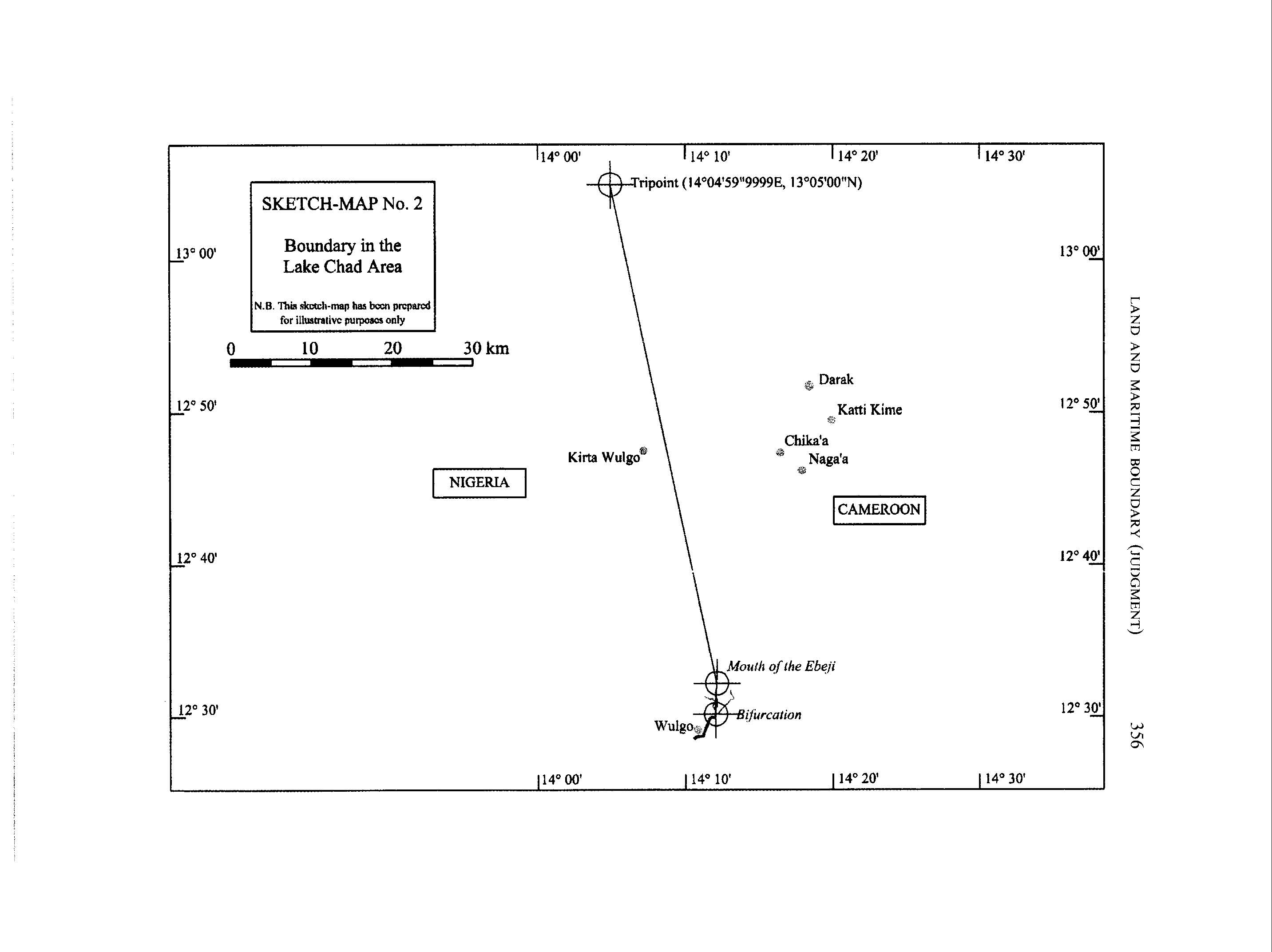
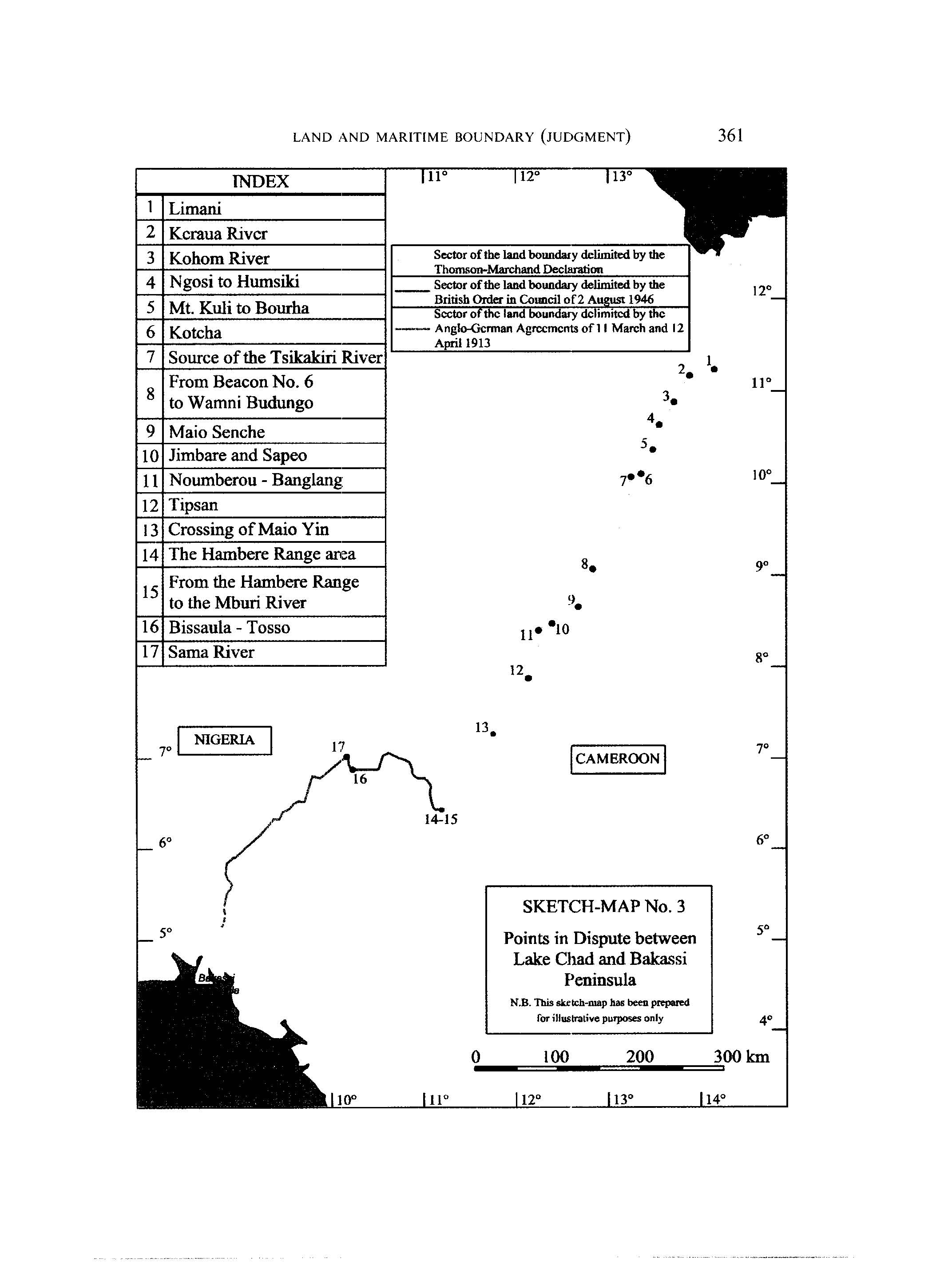
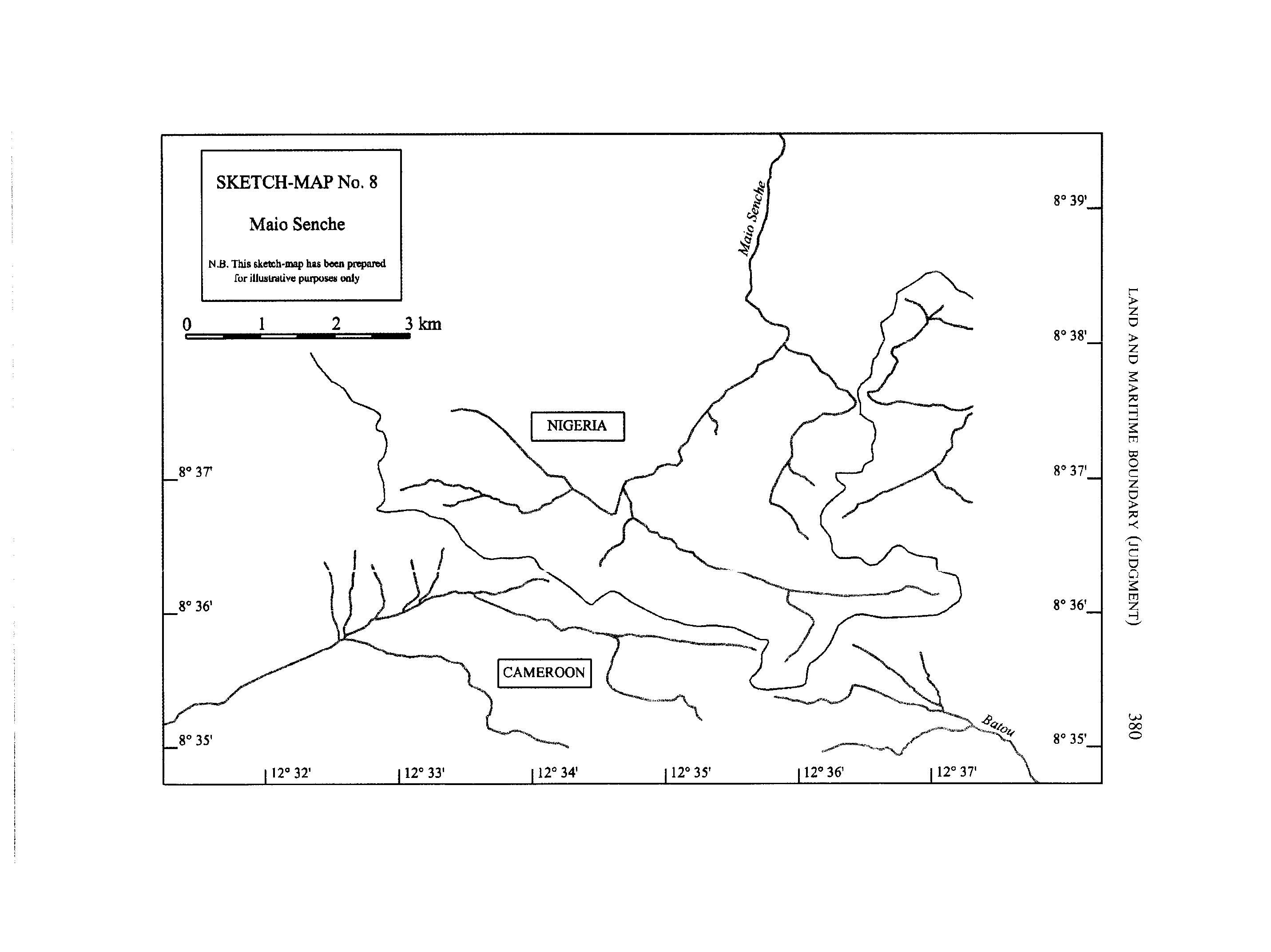
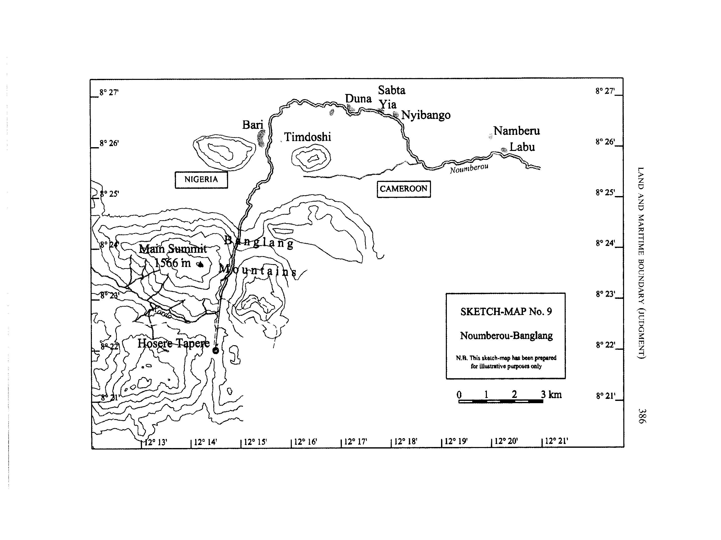
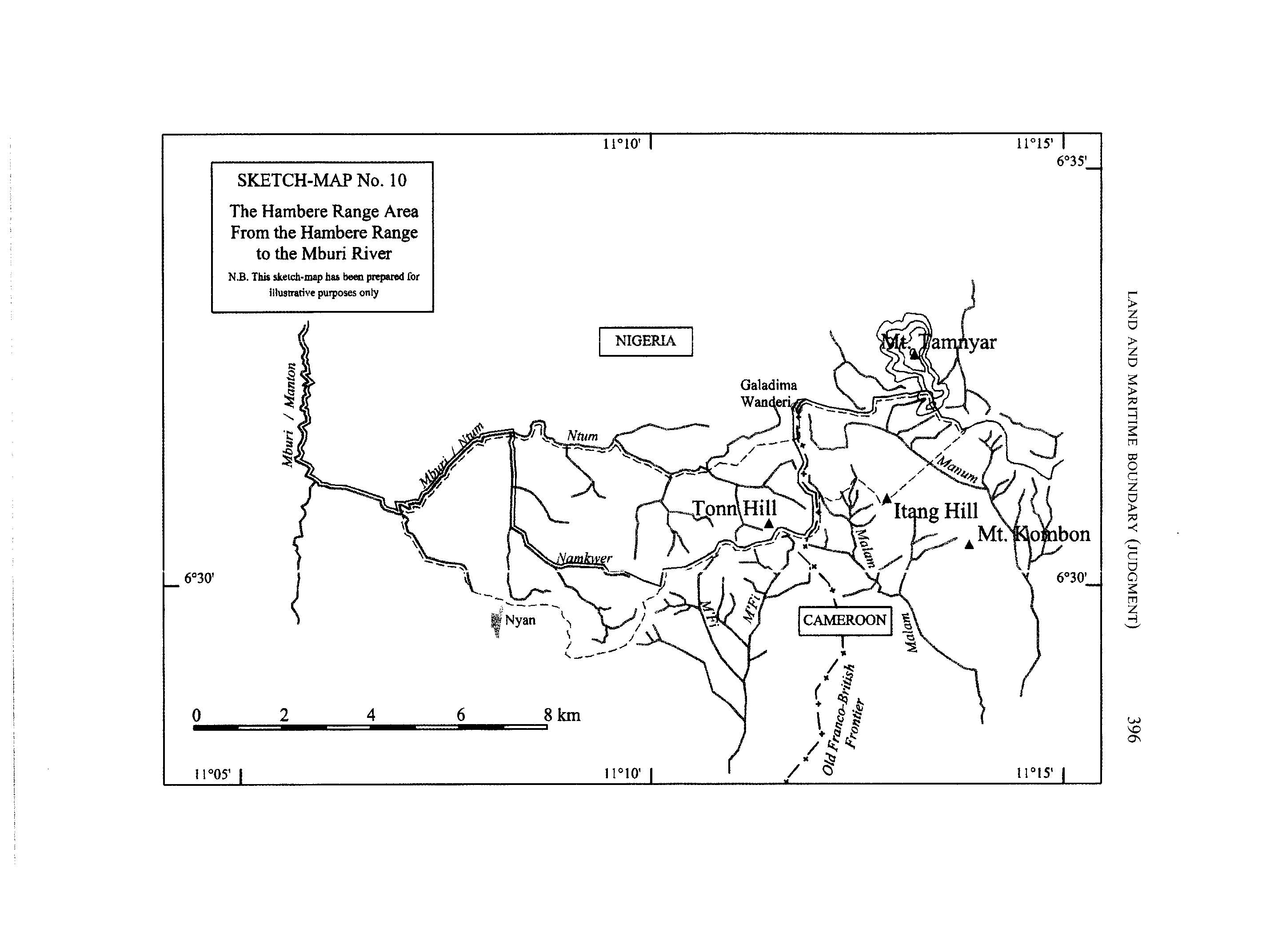
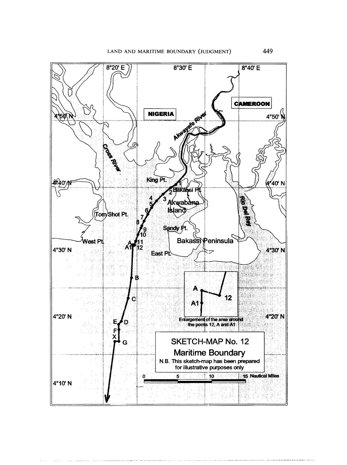