| |
[p1045]
The Court,
composed as above,
after deliberation,
delivers the following Judgment:
1. By joint letter dated 17 May 1996, filed in the Registry of the Court on
29 May 1996, the Ministers for Foreign Affairs of the Republic of Botswana
(hereinafter called "Botswana") and the Republic of Namibia (hereinafter
called "Namibia") transmitted to the Registrar the original text of a
Special [p1049] Agreement between the two States, signed at Gaborone on 15
February 1996 and entered into force on 15 May 1996, the date of exchange of
instruments of ratification.
2. The text of the Special Agreement reads as follows:
"Whereas a Treaty between Great Britain and Germany respecting the spheres
of influence of the two countries in Africa was signed on 1 July 1890 (the
Anglo-German Agreement of 1890);
Whereas a dispute exists between the Republic of Botswana and the Republic
of Namibia relative to the boundary around Kasikili/Sedudu Island;
Whereas the two countries are desirous of settling such dispute by peaceful
means in accordance with the principles of both the Charter of the United
Nations and the Charter of the Organization of African Unity;
Whereas the two countries appointed on 24 May 1992 a Joint Team of Technical
Experts on the Boundary between Botswana and Namibia around Kasikili/Sedudu
Island 'to determine the boundary between Namibia and Botswana around
Kasikili/Sedudu Island' on the basis of the Treaty of 1 July 1890 between
Great Britain and Germany respecting the spheres of influence of the two
countries in Africa and the applicable principles of international law;
Whereas the Joint Team of Technical Experts was unable to reach a conclusion
on the question referred to it and recommended 'recourse to the peaceful
settlement of the dispute on the basis of the applicable rules and
principles of international law';
Whereas at the Summit Meeting held in Harare, Zimbabwe, on 15 February 1995,
and attended by Their Excellencies President Sir Ketumile Masire of
Botswana, President Sam Nujoma of Namibia and President Robert Mugabe of
Zimbabwe, the Heads of State of the Republic of Botswana and the Republic of
Namibia, acting on behalf of their respective Governments, agreed to submit
the dispute to the International Court of Justice for a final and binding
determination;
Now therefore the Republic of Botswana and the Republic of Namibia have
concluded the following Special Agreement:
Article I
The Court is asked to determine, on the basis of the Anglo-German Treaty of
1 July 1890 and the rules and principles of international law, the boundary
between Namibia and Botswana around Kasikili/Sedudu Island and the legal
status of the island.
Article II
1. The proceedings shall consist of written pleadings and oral hearings.
2. The written pleadings shall include:
(a) Memorials submitted to the Court by each Party not later than nine
months after the notification of the Special Agreement is transmitted [p1050] to the Registrar of the Court in accordance with Article VII (2) of
this Special Agreement;
(b) Counter-Memorials submitted by each Party to the Court not later than
nine months after the date of submission of the Memorials;
(c) such other written pleadings as may be approved by the Court at the
request of either of the Parties, or as may be directed by the Court.
3. The written pleadings submitted to the Registrar shall not be
communicated to the other Party until the corresponding pleadings of that
Party have been received by the Registrar.
Article III
The rules and principles of international law applicable to the dispute
shall be those set forth in the provisions of Article 38, paragraph 1, of
the Statute of the International Court of Justice.
Article IV
The order of appearance in the oral pleadings shall be as agreed by the
Parties with the approval of the Court, or in the absence of agreement, as
directed by the Court.
Article V
The order of the written pleadings and oral submissions shall be without
prejudice to the burden of proof.
Article VI
The language of the proceedings shall be English.
Article VII
1. This agreement shall enter into force on the date of the exchange of
instruments of ratification by the two Governments.
2. It shall be notified to the Court as required by Article 40, paragraph 3,
of the Statute of the Court by joint letter of the Parties to the Registrar.
3. If such notification is not effected within two months from the entry
into force of this Special Agreement, it may be notified to the Registrar by
either of the Parties.
Article VIII
1. Each of the Parties may exercise its right under Article 31, paragraph 3,
of the Statute of the Court to choose a person to sit as judge.
2. A Party which chooses to exercise the right referred to in sub-Article 1,
above, shall notify the other Party in writing prior to exercising such
right.
Article IX
1. The judgment of the Court on the dispute described in Article I shall be
final and binding on the Parties.
2. As soon as possible after the delivery of the Court's judgment, the
Parties shall take steps necessary to carry out the judgment. [p1051]
In witness whereof, the undersigned, being duly authorized thereto, have
signed this Special Agreement and have affixed thereto their seals."
3. Pursuant to Article 40, paragraph 3, of the Statute and Article 42 of the
Rules of Court, copies of the notification and of the Special Agreement were
transmitted by the Registrar to the Secretary-General of the United Nations,
the Members of the United Nations and other States entitled to appear before
the Court.
4. By Order of 24 June 1996, the Court fixed 28 February 1997 as the
time-limit for the filing of a Memorial by each Party and 28 November 1997
as the time-limit for the filing by each Party of a Counter-Memorial, having
regard to the provisions of Article II, paragraph 2 (a) and (b), of the
Special Agreement. These pleadings were duly filed within the time-limits so
prescribed.
5. By Order of 27 February 1998, the Court fixed 27 November 1998 as the
time-limit for the filing of a Reply by each Party, having regard to the
provisions of Article II, paragraph 2 (c), of the Special Agreement and
taking account of the agreement between the Parties, as expressed in a joint
letter from their Agents dated 16 February 1998. The Replies were duly filed
within the time-limit so prescribed. As the Parties did not request the
submission of other pleadings, and as the Court itself did not consider this
necessary, the case was then ready for hearing.
6. In accordance with Article 53, paragraph 2, of the Rules of Court, the
Court decided, after having ascertained the views of the Parties, that
copies of the pleadings and documents annexed would be made available to the
public as from the opening of the oral proceedings.
7. New documents were produced by each of the Parties, with the consent of
the other, in accordance with Article 56, paragraph 1, of the Rules of
Court. In addition, Namibia, availing itself of the right provided for in
Article 56, paragraph 3, of the Rules of Court, submitted comments on
certain of the new documents produced by Botswana.
8. The Parties having been duly consulted, in accordance with Article 58,
paragraph 2, of the Rules of Court, and having informed the Court of their
agreement, in accordance with Article IV of the Special Agreement, on the
order of speaking, public sittings were held between 15 February and 5 March
1999, during which oral arguments and replies were heard from the following:
For Namibia: Dr. Albert Kawana,
Professor Abram Chayes,
Professor Dr. Jost Delbruck,
Professor W. J. R. Alexander,
Dr. Lazarus Hangula,
Professor Dr. Julio Faundez,
Colonel Dennis Rushworth,
Mr. Jean-Pierre Cot.
For Botswana: Mr. Abednego Batshani Tafa,
Mr. Molosiwa L. Selepeng,
Professor Ian Brownlie,
Lady Fox,
Dr. Stefan Talmon,
Professor F. T. K. Sefe,
Mr. Isaac Muzila.
[p1052]
At the sittings, each of the Parties showed a video cassette, after those
cassettes had been exchanged between the Parties through the intermediary of
the Registry.
Questions were also put by Members of the Court, to which both Parties
replied in writing, within the time-limit fixed for this purpose.
9. In the course of the written proceedings, the following submissions were
presented by the Parties:
On behalf of Botswana,
in the Memorial, the Counter-Memorial and the Reply:
"May it please the Court to adjudge and declare that:
1. The northern and western channel of the Chobe River in the vicinity of
Kasikili/Sedudu Island constitutes the 'main channel' of the Chobe River in
accordance with the provisions of Article III (2) of the Anglo-German
Agreement of 1890; and that:
2. Consequently, sovereignty in respect of Kasikili/Sedudu Island inheres
exclusively in the Republic of Botswana."
On behalf of Namibia,
in the Memorial and the Counter-Memorial:
"May it please the Court, rejecting all claims and submissions to the
contrary, to adjudge and declare:
1. The channel that lies to the south of Kasikili/Sedudu Island is the main
channel of the Chobe River.
2. The channel that lies to the north of Kasikili/Sedudu Island is not the
main channel of the Chobe River.
3. Namibia and its predecessors have occupied and used Kasikili Island and
exercised sovereign jurisdiction over it, with the knowledge and
acquiescence of Botswana and its predecessors since at least 1890.
4. The boundary between Namibia and Botswana around Kasikili/Sedudu Island
lies in the centre of the southern channel of the Chobe River.
5. The legal status of Kasikili/Sedudu Island is that it is a part of the
territory under the sovereignty of Namibia."
In the Reply:
"May it please the Court, rejecting all claims and submissions to the
contrary, to adjudge and declare
1. The channel that lies to the south of Kasikili/Sedudu Island is the main
channel of the Chobe River.
2. The channel that lies to the north of Kasikili/Sedudu Island is not the
main channel of the Chobe River.
3. Namibia and its predecessors have occupied and used Kasikili Island and
exercised sovereign jurisdiction over it, with the knowledge and
acquiescence of Botswana and its predecessors since at least 1890.
4. The boundary between Namibia and Botswana around Kasikili/Sedudu Island
lies in the centre (that is to say, the thalweg) of the southern channel of
the Chobe River. [p1053]
5. The legal status of Kasikili/Sedudu Island is that it is a part of the
territory under the sovereignty of Namibia."
10. In the oral proceedings, the following submissions were presented by the
Parties:
On behalf of Botswana,
at the hearing of 5 March 1999:
"May it please the Court:
(1) to adjudge and declare:
(a) that the northern and western channel of the Chobe River in the vicinity
of Kasikili/Sedudu Island constitutes the 'main channel' of the Chobe River
in accordance with the provisions of Article III (2) of the Anglo-German
Agreement of 1890; and
(b) consequently, sovereignty in respect of Kasikili/Sedudu Island vests
exclusively in the Republic of Botswana; and further
(2) to determine the boundary around Kasikili/Sedudu Island on the basis of
the thalweg in the northern and western channel of the Chobe River.”
On behalf of Namibia,
at the hearing of 2 March 1999:
***
The submissions read at the hearing were identical to those presented by
Namibia in the Reply.
11. The Parties, in the terms of the Special Agreement, request the Court,
"to determine, on the basis of the Anglo-German Treaty of 1 July 1890 and
the rules and principles of international law, the boundary between Namibia
and Botswana around Kasikili/Sedudu Island and the legal status of the
island." The Island referred to, which in Namibia is known as "Kasikili",
and in Botswana as "Sedudu", is approximately 3.5 square kilometres (1.5
square miles) in area. It is located in the Chobe River, which divides
around it to the north and south, in the area bounded approximately by
meridians 25 [degree] 07' and 25 [degree] 08' E longitude and parallels 17
[degree] 47' and 17 [degree] 50' S latitude, and is some 20 kilometres (12.5
miles) upstream of Kazungula where the Chobe flows into the Zambezi. The
Chobe has its source on the central plateau of Angola, where it is called
the Rio Cuando. It undergoes further changes of name at various stages along
its course. When it crosses the border into Namibia, it becomes the Kwando
and then the Mashi, which flows generally in a southerly direction into the
Linyanti (or Linyandi) Swamp. From this point it is called the Linyanti (or
Linyandi) River until it reaches Lake Liambezi. At the exit from the lake,
the river becomes the Chobe. The Botswana town of Kasane lies on the south
bank some 1.5 kilometres downstream from Kasikili/Sedudu Island, and the
Namibian village of Kasika is located on the northwestern bank of the Chobe.
12. Nearly due south of the Island, on the Botswana side, are the [p1054]
headquarters of the Chobe National Park, a protected reserve with a wide
variety of wildlife. This southern bank is characterized by a steep sandy
ridge ranging between 900 and 1,000 metres above mean sea level. The area on
the Namibian side, to the north of the Island, has no such geographical
feature. It forms part of a strip of territory called the "Caprivi Strip",
after the German chancellor at the time of the conclusion of the
Anglo-German Agreement of 1 July 1890 (hereinafter the "1890 Treaty"). This
part of the Caprivi Strip is within the seasonal flood plain of the Zambezi
River. The Island, which is 927 metres above mean sea level, forms part of
this plain, and is subject to flooding of several months' duration,
beginning around March. In order to assist in the reading of this Judgment,
the Court has included below three sketch-maps, the first illustrating the
position of Botswana and Namibia on the continent of Africa (Sketch-map No.
1); the second showing the Caprivi Strip and the Chobe (Sketch-map No. 2);
and the third showing Kasikili/Sedudu Island (Sketch-map No. 3).
13. The dispute between the Parties is set against the background of the
nineteenth century race among the European colonial powers for the partition
of Africa. In the spring of 1890, Germany and Great Britain entered into
negotiations with a view to reaching agreement concerning their trade and
their spheres of influence in Africa. In the south-west of the continent,
Great Britain sought to protect the south-north trade routes running through
Lake Ngami to Victoria Falls, while Germany, which had already laid claim to
a large portion of what was called "South West Africa", sought British
recognition of its access to the Zambezi. These negotiations culminated in
the conclusion of the 1890 Treaty, which concerned several regions of the
African continent, namely east Africa, south-west Africa, Togo and Zanzibar,
and involved the cession to Germany of the island of Heligoland, in exchange
for Zanzibar. The Treaty delimited inter alia the spheres of influence of
Germany and Great Britain in south-west Africa; that delimitation lies at
the heart of the present case.
14. In the ensuing century, the territories involved experienced various
mutations in status. The independent Republic of Botswana came into being on
30 September 1966, on the territory of the former British Bechuanaland
Protectorate. German administration of South West Africa turned out to be
short-lived. Upon the outbreak of the First World War in 1914, the Caprivi
Strip was occupied and governed by British forces from Southern Rhodesia.
From 1919 until 1966, South Africa was the administering authority of the
territory of South West Africa under a mandate from the League of Nations.
For part of this period, from 1921 to 1929, South Africa delegated the
administration of the Caprivi Strip to the authorities of the British
Bechuanaland Protectorate. South Africa's mandate over South West Africa was
terminated by the United Nations General Assembly in 1966, following which
the Assembly established a
[p1055]
Sketch-Map No. 1
[p1056]
[Map]
[p1057]
Sketch-Map No. 3
[p1058] United Nations Council for South West
Africa (which subsequently became the United Nations Council for Namibia),
which it designated as the authority responsible for the administration of
Namibia; but South Africa remained in de facto control of the territory,
despite United Nations policy to the contrary, until Namibia's independence
on 21 March 1990.
15. Shortly after Namibian independence, differences arose between the two
States concerning the location of the boundary around Kasikili/Sedudu
Island. When the two Parties proved unable to resolve their dispute, they
called upon the good offices of the President of Zimbabwe. His efforts led
to a meeting of the Presidents of the three countries at Kasane, Botswana,
in May 1992, at which they issued a communique, declaring that the issue
should be resolved peacefully, and recording the Presidents' agreement to
submit the determination of the boundary around Kasikili/Sedudu Island to a
Joint Team of Technical Experts. Terms of reference for the Joint Team were
agreed between the parties in December 1992, and the Joint Team conducted
its survey between September 1993 and August 1994. In its final Report,
issued on 20 August 1994, the Joint Team announced that it had failed to
reach an agreed conclusion on the question put to it, and recommended
recourse to the peaceful settlement of the dispute on the basis of the
applicable rules and principles of international law.
16. In February 1995, the three Presidents met in Harare, Zimbabwe, to
consider the Joint Team Report. At this meeting, it was decided to submit
the dispute to the International Court of Justice for a final and binding
determination. Pursuant to this decision, Botswana and Namibia, by a Special
Agreement signed at Gaborone on 15 February 1996, brought the dispute before
the Court.
***
17. The Court recalls that according to Article I of the Special Agreement,
it:
"is asked to determine, on the basis of the Anglo-German Treaty of 1 July
1890 and the rules and principles of international law, the boundary between
Namibia and Botswana around Kasikili/Sedudu Island and the legal status of
the island".
Accordingly the Court has a dual task: to determine both the boundary
between Botswana and Namibia around Kasikili/Sedudu Island and the legal
status of the Island. For this purpose, the Court must base itself on the
1890 Treaty and on the rules and principles of international law.
*[p1059]
18. The law applicable to the present case has its source first of all in
the 1890 Treaty, which Botswana and Namibia acknowledge to be binding on
them.
As regards the interpretation of that Treaty, the Court notes that neither
Botswana nor Namibia are parties to the Vienna Convention on the Law of
Treaties of 23 May 1969, but that both of them consider that Article 31 of
the Vienna Convention is applicable inasmuch as it reflects customary
international law. The Court itself has already had occasion in the past to
hold that customary international law found expression in Article 31 of the
Vienna Convention (see Territorial Dispute (Libyan Arab Jamahiriya/Chad),
Judgment, I.C.J. Reports 1994, p. 21, para. 41; Oil Platforms (Islamic
Republic of Iran v. United States of America), Preliminary Objections,
Judgment, I.C.J. Reports 1996 (II), p. 812, para. 23). Article 4 of the
Convention, which provides that it "applies only to treaties which are
concluded by States after the entry into force of the . . . Convention with
regard to such States" does not, therefore, prevent the Court from
interpreting the 1890 Treaty in accordance with the rules reflected in
Article 31 of the Convention.
According to Article 31 of the Vienna Convention on the Law of Treaties:
"1. A treaty shall be interpreted in good faith in accordance with the
ordinary meaning to be given to the terms of the treaty in their context and
in the light of its object and purpose.
2. The context for the purpose of the interpretation of a treaty shall
comprise, in addition to the text, including its preamble and annexes:
(a) any agreement relating to the treaty which was made between all the
parties in connection with the conclusion of the treaty;
(b) any instrument which was made by one or more parties in connection with
the conclusion of the treaty and accepted by the other parties as an
instrument related to the treaty."
19. The Special Agreement also refers, in Article I, to the "rules and
principles of international law". Article III of the Special Agreement
further states that these rules and principles "shall be those set forth in
the provisions of Article 38, paragraph 1, of the Statute of the
International Court of Justice". The Court will revert to the issue - in
dispute between the parties - of whether this reference in the Special
Agreement to the "rules and principles of international law" permits the
Court to entertain Namibia's alternative argument founded on the doctrine of
prescription (see paragraphs 90-94 below).
The Parties also refer to the principles of both the Charter of the United
Nations and the Charter of the Organization of African Unity (OAU), as well
as to esolution AHG/Res. 16 (1), adopted in Cairo on 21 July 1964 by the
Assembly of Heads of State and Government of the OAU. The latter provides
that Member States of the OAU pledge themselves inter alia to respect the
frontiers existing on their achievement [p1060] of national independence
(an implementation of the principle of uti possedetis juris).
***
20. The Court will now proceed to interpret the provisions of the 1890
Treaty by applying the rules of interpretation set forth in the 1969 Vienna
Convention. It recalls that
"a treaty must be interpreted in good faith, in accordance with the ordinary
meaning to be given to its terms in their context and in the light of its
object and purpose. Interpretation must be based above all upon the text of
the treaty. As a supplementary measure recourse may be had to means of
interpretation such as the preparatory work of the treaty." (Territorial
Dispute (Libyan Arab Jamahiriya/Chad), Judgment, I.C.J. Reports 1994, pp.
21-22, para. 41.)
In order to illuminate the meaning of words agreed upon in 1890, there is
nothing that prevents the Court from taking into account the present-day
state of scientific knowledge, as reflected in the documentary material
submitted to it by the Parties (compare Controversia sobre el recorrido de
la traza del limite entre el Hito 62 y el Monte Fitz Roy (Argentina/Chile)
[Dispute concerning the course of the frontier between B.P. 62 and Mount
Fitzroy (Argentina/Chile)], also known as the "Laguna del desierto" case,
Arbitral Award of 21 October 1994, International Law Reports (ILR), Vol.
113, p. 76, para. 157; Revue generale de droit international public (RGDIP),
Vol. 2, 1996, p. 592, para. 157).
21. The Court will first examine the text of the 1890 Treaty, Article III of
which reads as follows:
"In Southwest Africa the sphere in which the exercise of influence is
reserved to Germany is bounded:
1. To the south by a line commencing at the mouth of the Orange river, and
ascending the north bank of that river to the point of its intersection by
the 20th degree of east longitude.
2. To the east by a line commencing at the above-named point, and following
the 20th degree of east longitude to the point of its intersection by the
22nd parallel of south latitude; it runs eastward along that parallel to the
point of its intersection by the 21st degree of east longitude; thence it
follows that degree northward to the point of its intersection by the 18th
parallel of south latitude; it runs eastward along that parallel till it
reaches the river Chobe, and descends the centre of the main channel of that
river to its junction with the Zambesi, where it terminates.
It is understood that under this arrangement Germany shall have free access
from her Protectorate to the Zambesi by a strip of territory which shall at
no point be less than 20 English miles in width. [p1061]
The sphere in which the exercise of influence is reserved to Great Britain
is bounded to the west and northwest by the above-mentioned line. It
includes Lake Ngami.
The course of the above boundary is traced in general accordance with a map
officially prepared for the British Government in 1889."
As far as the region covered by the present case is concerned, this
provision locates the dividing line between the spheres of influence of the
contracting parties in the "main channel" of the River Chobe; however,
neither this, nor any other provision of the Treaty, furnishes criteria
enabling that "main channel" to be identified. It must also be noted that
the English version refers to the "centre" of the main channel, while the
German version uses the term "thalweg" of that channel (Thalweg des
Hauptlaufes).
22. Throughout the proceedings, the Parties have expressed differing
opinions regarding the method to be applied for the purpose of interpreting
these expressions.
Botswana contends that:
"in a bifurcated stretch of river, such as the Chobe River in the vicinity
of Kasikili/Sedudu Island, both channels will have their respective
thalwege. However, the thalweg of the main channel will be at a lower
elevation than the thalweg of the other channel. Only the thalweg of the
main channel can be logically connected to the thalweg of the channel
upstream of the point of bifurcation and downstream of the point of
reunion."
Botswana maintains that, in order to establish the line of the boundary
around Kasikili/Sedudu Island, it is sufficient to determine the thalweg of
the Chobe; it is that which identifies the main channel of the river. For
Botswana, the words "des Hauptlaufes" therefore add nothing to the text.
23. For Namibia, however, the task of the Court is first to identify the
main channel of the Chobe around Kasikili/Sedudu Island, and then to
determine where the centre of this channel lies:
"The 'main channel' must be found first; the 'centre' can necessarily only
be found afterward. This point is equally pertinent to the German
translation of the formula '. . . im Thalweg des Hauptlaufes . . .' In the
same way as with the English text, the search must first be for the
'Hauptlauf' and for the 'Thalweg' only after the 'Hauptlauf' has been found.
The 'Hauptlauf' cannot be identified by first seeking to find the
'Thalweg'."
24. The Court notes that various definitions of the term "thalweg" are found
in treaties delimiting boundaries and that the concepts of the thalweg of a
watercourse and the centre of a watercourse are not equivalent. The word
"thalweg" has variously been taken to mean "the most suitable channel for
navigation" on the river, the line "determined by the line of [p1062]
deepest soundings", or "the median line of the main channel followed by
boatmen travelling downstream". Treaties or conventions which define
boundaries in watercourses nowadays usually refer to the thalweg as the
boundary when the watercourse is navigable and to the median line between
the two banks when it is not, although it cannot be said that practice has
been fully consistent.
25. The Court further notes that at the time of the conclusion of the 1890
Treaty, it may be that the terms "centre of the [main] channel" and
"Thalweg" des Hauptlaufes were used interchangeably. In this respect, it is
of interest to note that, some three years before the conclusion of the 1890
Treaty, the Institut de droit international stated the following in Article
3, paragraph 2, of the "Draft concerning the international regulation of
fluvial navigation", adopted at Heidelberg on 9 September 1887: "The
boundary of States separated by a river is indicated by the thalweg, that is
to say, the median line of the channel" (Annuaire de l'Institut de droit
international, 1887-1888, p. 182), the term "channel" being understood to
refer to the passage open to navigation in the bed of the river, as is clear
from the title of the draft. Indeed, the parties to the 1890 Treaty
themselves used the terms "centre of the channel" and "thalweg" as synonyms,
one being understood as the translation of the other (see paragraph 46
below).
The Court observes, moreover, that in the course of the proceedings,
Botswana and Namibia did not themselves express any real difference of
opinion on this subject. The Court will accordingly treat the words "centre
of the main channel" in Article III, paragraph 2, of the 1890 Treaty as
having the same meaning as the words "Thalweg des Hauptlaufes" (cf. 1969
Vienna Convention on the Law of Treaties, Article 33, paragraph 3, under
which "the terms of the treaty are presumed to have the same meaning in each
authentic text").
26. The Court adds that, in this case, the Parties to the dispute have used
the term "channel" to refer to each of the two branches of the Chobe that
ring Kasikili/Sedudu Island, and have not confined the term "channel" to the
stricter usage meaning the navigable passage of a river or of one of its
branches. In view of this fact, the Court itself in this Judgment will
likewise employ the term "channel" in a broad sense.
27. In the Court's opinion, the real dispute between the Parties concerns
the location of the main channel where the boundary lies. In Botswana's
view, it is to be found "on the basis of the thalwegs in the northern and
western channel of the Chobe", whereas in Namibia's view, it "lies in the
centre (that is to say thalweg) of the southern channel of the Chobe River".
While Botswana thought it sufficient for the Court to locate the line of
deepest soundings in this section of the Chobe, which in its view leads to
the centre of the northern channel as the boundary, the Court notes that
this was not the only test it relied on. Moreover, the Court observes that
by introducing the term "main channel" into the draft treaty, the con-[p1063]tracting parties must be assumed to have intended that a precise
meaning be given to it. For these reasons, the Court will therefore proceed
first to determine the main channel. In so doing, it will seek to determine
the ordinary meaning of the words "main channel" by reference to the most
commonly used criteria in international law and practice, to which the
Parties have referred.
**
28. Before entering into an examination of these criteria, the Court
observes that the Parties' experts have submitted to it extensive, often
contradictory, information on the distinguishing features of the Chobe.
For Botswana, the Chobe "is a perennial river independent of the Zambezi
River, with a stable profile, continuous downstream flow and visible and
stable banks".
Namibia, for its part, claims that the Chobe cannot be regarded as a
perennial river, and that in reality it is an ephemeral watercourse. Namibia
points out that the Chobe is very often dry over a substantial section of
its course, so that it is not navigable over most of its length.
The Court does not find itself charged with making findings on the
distinguishing features of the Chobe River. It will take these into account
only in so far as they affect the sector of Kasikili/Sedudu Island. The
Court's task is in fact limited to settling the dispute between Botswana and
Namibia by determining the boundary between these two States around the
Island as well as the legal status of the Island.
29. The Parties to the dispute agree on many of the criteria for identifying
the "main channel", but disagree on the relevance and applicability of
several of those criteria.
For Botswana, the relevant criteria are as follows: greatest depth and
width; bed profile configuration; navigability; greater flow of water.
Botswana also lays stress, in the following terms, on the importance, from
the standpoint of identification of the main channel, of "channel capacity",
"flow velocity" and "volume of flow":
"channel capacity - This is determined by width and depth of the channel and
in the discharge equation it is represented by cross-sectional area. From
the cross-section survey and the analysis of satellite imagery, it is clear
that the northern channel is deeper than the southern channel. . . .
flow velocity - Flow velocity is a function of bed slope, hydraulic radius
and roughness coefficient. . . . the northern channel has a steeper bed
slope; both of its banks are smooth (compared to the southern channel),
therefore velocity will be higher in that channel.
volume of flow - Volume of flow in a channel is computed as the [p1064]
product of channel capacity (cross-section area) and mean velocity through
the cross-section."
Namibia acknowledges that
"possible criteria for identifying the main channel in a river with more
than one channel are the channel with the greatest width, or the greatest
depth, or the channel that carries the largest proportion of the annual flow
of the river. In many cases the main channel will have all three of these
characteristics."
It adds, however, referring to the sharp variations in the level of the
Chobe's waters, that: "neither width nor depth are suitable criteria for
determining which channel is the main channel."
Namibia nevertheless further states the following:
"Various criteria may be employed; these include width, depth, velocity,
discharge, and sediment transport capacity. Since discharge is the product
of width, mean depth and mean velocity, and is a determinant of transport
capacity, it is the most straightforward and general criterion."
Among the possible criteria, Namibia therefore attaches the greatest weight
to the amount of flow: according to Namibia, the main channel is the one
"that carries the largest proportion of the annual flow of the river".
Namibia also emphasized that another key task was to identify the channel
that is "most used for river traffic".
30. The Court finds that it cannot rely on one single criterion in order to
identify the main channel of the Chobe around Kasikili/Sedudu Island,
because the natural features of a river may vary markedly along its course
and from one case to another. The scientific works which define the concept
of "main channel" frequently refer to various criteria: thus, in the
Dictionnaire francais d'hydrologie de surface avec equivalents en anglais,
espagnol, allemand (Masson, 1986), the "main channel" is "the widest,
deepest channel, in particular the one which carries the greatest flow of
water" (p. 66); according to the Water and Wastewater Control Engineering
Glossary (Joint Editorial Board Representing the American Public Health
Association, American Society of Civil Engineers, American Water Works
Association and Water Pollution Control Federation, 1969), the "main
channel" is "the middle, deepest or most navigable channel" (p. 197).
Similarly, in the Rio Palena Arbitration, the arbitral tribunal appointed by
the Queen of England applied several criteria in determining the major
channel of a boundary river (Argentina-Chile Frontier Case (1966), United
Nations, Reports of International Arbitral Awards (RIAA), Vol. XVI, pp.
177-180; International Law Reports (ILR), Vol. 38, pp. 94-98). The Court
notes that the Parties have expressed their views on one or another aspect
of the criteria mentioned in paragraph 29 above, distinguishing between them
or placing emphasis [p1065] on their complementarity and their relationship
with other criteria. It will take into account all of these criteria.
31. Before coming to a conclusion on the respective role and significance of
the various criteria thus chosen, the Court notes, on the basis of the
information supplied by both Parties concerning the hydrological situation
of Kasikili/Sedudu Island, that there are compelling reasons for assuming
that this situation has seen no radical change over the last hundred years.
The aerial photographs taken in 1925, 1943, 1947, 1962, 1972, 1977, 1981 and
1985 show no major mutation in the channels of the Chobe and indicate that
the channels surrounding the Island remained relatively stable throughout
that period of time. Moreover, the Parties are in agreement on this point.
Namibia states on this count:
"Namibia's position does not depend on any changes in the general
configuration of the Island and the surrounding area since the Treaty was
signed. Thus, Namibia accepts that there have been no significant changes in
the location of the northern and southern channels since 1890."
Similarly, Botswana affirms that there
"is a complete absence of any evidence of radical change in the course of
the Chobe. Large scale maps both before and after the 1890 Anglo-German
Agreement, prepared by those who had actually surveyed this stretch of the
Chobe River, show an unchanged course."
In short, the present hydrological situation of the Chobe around
Kasikili/Sedudu Island may be presumed to be essentially the same as that
which existed when the 1890 Treaty was concluded.
32. The Court will first examine the criterion of depth. According to
Botswana's experts, the mean depth of the northern channel is 5.70 metres,
clearly exceeding the mean depth of the southern channel by 2.13 metres. As
for the shallowest points, the depth is said to be 1.5 to 2 metres at the
entry to the southern channel, i.e., a much shallower depth than in the
northern channel.
Although Namibia agrees that the northern channel has the greater mean
depth, it disputes that this conclusion is of any importance whatsoever for
determining the main channel. It maintains that what is important in this
respect is not mean depth but draught at the shallowest point of the
channel; and it asserts that any differences between the shallowest points
in the northern and southern channels are minute. For Namibia, the results
of the 1985 Joint Survey (see paragraph 64 below) in respect of the minimum
depth of the two channels (see Reply of Namibia, Vol. II, Second
supplementary report to the expert report on the identification of the main
channel of the Chobe River at Kasikili Island, Fig. 14) are incon-[p1066]clusive, in so far as "the minimum thalweg depths of the two channels
within the bifurcation zone were not determined" Namibia also introduced
photographs showing a herd of elephants crossing the two channels of the
Chobe, but produced no figures to show that the minimum depth of the
southern channel was greater than that of the northern channel.
Notwithstanding all the difficulties involved in sounding the depth of the
channels and interpreting the results, the Court concludes that the northern
channel is deeper than the southern one as regards mean depth, and even as
regards minimum depth.
33. The Court will now consider the criterion of width. The width of a river
may increase or decrease in line with the variable level of its waters. In
order to deal with this phenomenon, the width has often been determined on
the basis of the low water mark (see, e.g., Article IX of the Boundary
Convention between Baden and France of 30 January 1827 (De Clerq, Recueil
des Traites de la France, Vol. III, pp. 429 et seq.); see also the judgment
of the United States Supreme Court of 19 May 1933 in the case Vermont v. New
Hampshire, United States Reports, Vol. 289, p. 619 (1933)) or the mean water
level (see, e.g., the Arbitral Award rendered on 23 January 1933 by the
Special Boundary Tribunal constituted by the Treaty of Arbitration between
Guatemala and Honduras (League of Nations Treaty Series, Vol. 137, p. 259;
United Nations Reports of International Arbitral Awards (RIAA), Vol. II, p.
1365)), which offer an acceptable basis for defining the characteristic
features of a watercourse (channels, centre, flow, etc.).
As early as 1912, Captain Eason, of the Bechuanaland Police, after having
visited the area, described the northern channel as being twice the width of
the southern channel (see paragraph 53 below). The aerial photographs of the
area concerned taken between 1925 and 1985 show a northern channel that is
wider than the southern one. The satellite pictures taken in June 1975, then
in March 1995 and June 1996 - i.e., in both the dry and rainy seasons - show
the northern channel as being wider than the southern channel. The Court
concludes that apart from the season of flooding that is indeed the
situation.
34. The Parties both agree that the flow, i.e., the volume of water carried,
plays an important role, and for Namibia even a decisive role, in
determining the main channel - although they do not reach the same
conclusion.
According to the data submitted by Botswana,
"the northern channel conveys about twice as much flow as the southern
channel. The mean discharge at Site II in the northern channel is 78.865
m3/s compared to 41.823 m3/s at Site I in the southern channel... Notice
that the ratio of roughly 1:2 between [p1067] the mean discharges of the
southern and northern channels also applies to the median and maximum
discharges."
Namibia criticizes this choice of gauging points, as well as the methods
used, and disputes the accuracy of the figures provided by Botswana. For its
part, it contends that
"the southern channel carries not only the major portion, but substantially
all of the flow of the River in the vicinity of Kasikili Island, while the
northern channel has almost no longitudinal flow and is little more than a
relict channel of the Zambezi floodplain".
Namibia provides the following figures for the volume of flow during the
period from 30 April to 2 May 1998:
"In the main channel to the south of the Island, the flow was 247 m3/s,
i.e., almost 60% of the total. In the northern channel it was 188 m3/s."
35. The Court is not in a position to reconcile the figures submitted by the
Parties, who take a totally different approach to the definition of the
channels concerned. In Botswana's presentation, the two channels around
Kasikili/Sedudu Island are those visible on the map (reproduced on page 25
of this Judgment). For its part, Namibia argues, placing particular reliance
on certain maps and images, in support of the existence of a major channel
of the Chobe, of which the southern channel - visible throughout the year
except when the river is in flood - merely constitutes the thalweg (see the
aerial photograph reproduced on page 26 of this Judgment). According to
Namibia, "the left bank [of this large channel] is marked by the line of
high ground crossing the Island in a west-east direction". This is the
channel said to carry "the largest proportion of the annual flow of the
river" and therefore to constitute the main channel of the Chobe in the
sector of Kasikili/Sedudu Island. On a number of the photographs and maps
submitted by Namibia (including the photograph reproduced on page 26 of this
Judgment), the banks of this channel, described as the main channel, are
shown by means of arrows or by a continuous line.
36. Botswana vigorously disputes the existence of this channel. It states
the following:
"[Firstly], the surmised Namibian waterway across the Island occupies one
sixth to one fifth of the northern channel. Secondly, it traverses the high
elevations of the Island. Thirdly, the proposed line of its left bank, on
examination of the aerial photographs and satellite images, is not a bank
but a narrow sub-channel. Fourthly, that line is not tree-lined; and
fifthly, the lower eastern areas of the Island, on the evidence, are the
more probable path of overflow of Zambezi floods."
[p1068]
Map Showing the Two Channels around
Kasikili/Sedudu Island According to Botswana
[p1069]
Photograph Showing the Two Channels
around Kasikili/Sedudu Island According to Namibia
[p1070]
In short, Botswana states, there is
"no independent evidence to support the existence of a 'channel', let alone
a 'main' one across the Island in the terms of Article III of the
Anglo-German Agreement of 1890".
37. The Court is of the opinion that the determination of the main channel
must be made according to the low water baseline and not the floodline (see
in this regard the practice referred to in paragraph 33 above). The evidence
shows that when the river is in flood, the Island is submerged by flood
water and the entire region takes on the appearance of an enormous lake.
Since the two channels are then no longer distinguishable, it is not
possible to determine the main channel in relation to the other channel. As
for the channel described by Namibia as the main channel, the Court finds
that the largest part of its bed remains dry for the greater part of the
year. High sand bars which are among the highest points of the Island (927
metres above sea-level) are found there, but it must also be noted that it
was in this bed that cultivation took place, according to the evidence of a
1943 aerial photograph submitted by both Parties. It is difficult to accept
that this bed, generally dry, and which would occupy the south-western part
of the Island, can be the bed of the main channel. The Court therefore is
not persuaded by Namibia's argument concerning the existence of this major
"main" channel whose visible southern channel would merely constitute the
thalweg.
38. Namibia emphasizes the importance of the Chobe Ridge in the area in
question as a "stable and clearly visible escarpment some 50 metres high";
it uses this as an argument for determining the main channel, by maintaining
that the right bank of the southern channel, which follows the Chobe Ridge,
has certain characteristics ("a steep, well-defined bank with a strip of
riverine vegetation along it") that make it readily identifiable. The Court
would observe that, even if one part of the right bank of this channel is
easily identifiable from a distance, other parts of this bank are not, and
neither is the left bank. The Court is therefore unable to conclude that, in
terms of visibility - or of general physical appearance - the southern
channel is to be preferred to the northern channel.
39. The Court turns now to the criteria put forward by Botswana concerning
"bed profile configuration". The Court finds that the northern channel of
the Chobe, around Kasikili/Sedudu Island, does not contain any of the
meanders that are so typical of the secondary branches of watercourses. The
southern channel, however, does show such meanders. Namibia indeed
acknowledges the curved nature of the southern channel but, in light of the
sediment deposition, draws contrary conclusions with regard to the
importance of this channel. Having examined the arguments, maps and
photographs put forward by the Parties, the Court is unable to conclude
that, from its bed configuration, the southern channel constitutes the
principal and natural prolongation of the course of the Chobe before the
bifurcation. [p1071]
40. The navigability of a watercourse is the combined result of its depth,
its width and the volume of water it carries, taking account of natural
obstacles such as waterfalls, rapids, shallow points, etc., along its
course. The Parties to the dispute do not accord equal importance to
navigability in the determination of the main channel of the Chobe. Botswana
maintains that "in the period at which the [1890] Treaty was concluded . . .
navigability and access to navigable waters were primary considerations in
the minds of the negotiators". In Namibia's view, on the other hand, "it
would be anomalous to apply a criterion of navigability to a river boundary
that is non-navigable for most of its length"; Namibia attaches no less
importance to the actual use of the southern channel of the Chobe around
Kasikili/Sedudu Island for the purpose of navigation by tourist vessels.
The Court notes that the navigability of watercourses varies greatly,
depending on prevailing natural conditions. Those conditions can prevent the
use of the watercourse in question by large vessels carrying substantial
cargoes, but permit light flat-bottomed vessels to navigate. In the present
case, the data furnished by the Parties tend to prove that the navigability
of the two channels around Kasikili/Sedudu Island is limited by their
shallowness. This situation inclines the Court to the view that, in this
respect, the "main channel" in this part of the Chobe is that of the two
which offers more favourable conditions for navigation. In the Court's view,
it is the northern channel which meets this criterion.
In 1947, Mr. W. Ker, the proprietor of the Zambezi Transport & Trading
Company, sought permission to transport timber by barge via the northern
channel of the Chobe from Serondella (upstream) to Katambora (downstream),
the southern channel being unusable for that purpose (see paragraph 56
below). The Court has no information regarding the volume of timber carried,
the duration of this undertaking or its success; nor has it been informed of
other attempts which may have been made to utilize the Chobe for
navigational purposes. This absence of data enables the Court to conclude
that the economic importance of navigation, even in the northern channel,
has remained slight. However, it follows from the Trollope-Redman
correspondence of 1948 - which correspondence the Court will consider later
(see paragraph 58 below) - that the northern channel of the Chobe was
regarded as a "stretch of water . . . navigable and giv[ing] access to the
higher reaches of the Chobe - [unlike] the southern channel". This
correspondence also indicates that "the Southern Channel [was] not navigable
by [timber] barges when the river [was] not in flood".
Moreover, the use of the southern channel by flat-bottomed tourist boats
does not in itself prove that the latter offers more favourable conditions
for navigation than the northern channel. In the view of the Court, the
presence of these tourist boats in the southern channel is attributable to
the spectacle of large wild animals and the wealth of fauna [p1072] on the
banks of the southern channel. The economic importance of tourism in the
southern channel does not alter its conditions of navigability. The Court
cannot therefore regard the amount of tourist craft in the southern channel
as a reason for modifying the conclusion that it has reached above.
41. For the foregoing reasons, the Court concludes that, in accordance with
the ordinary meaning of the terms that appear in the pertinent provision of
the 1890 Treaty, the northern channel of the River Chobe around
Kasikili/Sedudu Island must be regarded as its main channel.
42. This conclusion is supported by the results of various on-site
investigations, as recorded in the reports drawn up on those occasions. The
Court will revert in greater detail to these reports when it considers their
legal significance in the course of its examination of the conduct of the
Parties subsequent to the 1890 Treaty (see paragraphs 52-70 below). At this
stage it would nonetheless note the following points:
(1) in 1912, Captain H. E. Eason, of the Bechuanaland Police, travelled
through the area in question and concluded as follows in his reconnaissance
report:
"Here [i.e., around Kissikiri (Kasikili) Island], I consider that
undoubtedly the north should be claimed as the main channel. At the western
end of the island the north channel at this period of the year is over one
hundred feet wide and 8 feet deep, the south channel about forty feet wide
and four feet deep. The south channel is merely a back water, what current
there is goes round the North"
(2) a joint report drawn up on 19 January 1948 by Messrs. L. F. W. Trollope
and N. V. Redman, respectively Magistrate of the Eastern Caprivi Strip and
District Commissioner at Kasane (Bechuanaland), contains the following
conclusions on this point:
"We express the opinion that the 'main Channel' lies in the waterway which
would include the island in question in the Bechuanaland Protectorate";
(3) the joint report drawn up on 15 July 1985 by a joint team of experts
from South Africa and Botswana resulted in the following conclusion: "The
main channel of the Chobe River now passes Sidudu/Kasikili Island to the
west and to the north of it."
Thus, the three on-site surveys carried out at different times concluded
that the main channel of the River Chobe was the northern channel.
*
43. The Court will now consider how and to what extent the object and
purpose of the treaty can clarify the meaning to be given to its terms. [p1073] While the treaty in question is not a boundary treaty proper but a
treaty delimiting spheres of influence, the Parties nonetheless accept it as
the treaty determining the boundary between their territories. The major
concern of each contracting party was to protect its sphere of influence
against any intervention by the other party and to obviate any risk of
future disputes. Article VII of the 1890 Treaty is worded as follows:
"The two Powers engage that neither will interfere with any sphere of
influence assigned to the other by Articles I to IV. One Power will not in
the sphere of the other make acquisitions, conclude Treaties, accept
sovereign rights or Protectorates, nor hinder the extension of influence of
the other.
It is understood that no Companies nor individuals subject to one Power can
exercise sovereign rights in a sphere assigned to the other, except with the
assent of the latter."
The contracting powers, by opting for the words "centre of the main
channel", intended to establish a boundary separating their spheres of
influence even in the case of a river having more than one channel. They
possessed only rudimentary information about the Chobe's channels. If they
knew that such channels existed, their number, features, navigability, etc.,
and their relative importance remained unknown to them. This situation
explains the method adopted to define the southern boundary of the Caprivi
Strip.
The Court stated in the Temple of Preah Vihear, (Merits) case:
"There are boundary treaties which do no more than refer to a watershed
line, or to a crest line, and which make no provision for any delimitation
in addition." (I.C.J. Reports 1962, p. 34.)
In that Judgment the Court added that this was "an obvious and convenient
way of describing a frontier line objectively, though in general terms"
(ibid., p. 35). In the present case, the contracting parties employed a
similar approach.
44. The Court notes that navigation appears to have been a factor in the
choice of the contracting powers in delimiting their spheres of influence.
The great rivers of Africa traditionally offered the colonial powers a
highway penetrating deep into the African continent. It was to gain access
to the Zambezi that Germany sought "a strip of territory which shall at no
point be less than 20 English miles in width" - terms which were eventually
included in the provisions of Article III, paragraph 2, of the Treaty.
Admittedly, this strip of territory did provide access to the Zambezi, but
its southern boundary was formed by the Chobe River, which was apparently
assumed to be navigable, as suggested by the use of [p1074] the word
"thalweg" in the text of the German version of the Treaty. The difficulties
of the land route owing to regular flooding, and the obstacles to navigation
on the Chobe, were, in all probability, little known at the time.
45. The fact that the words "centre of the main channel" were included in
the draft Treaty on the initiative of the British Government suggests that
Great Britain no less than Germany sought to have access to the Zambezi. In
order to mark the separation of their spheres of influence, the contracting
parties chose "the centre of the main channel" of the Chobe, thus ensuring
that there was a well-defined, recognizable boundary, in a watercourse that
was assumed to be navigable. There are grounds for thinking that one of the
reasons underlying their decision was navigation, but the Court does not
consider that navigation was the sole objective of the provisions of Article
III, paragraph 2, of the Treaty. In referring to the main channel of the
Chobe, the parties sought both to secure for themselves freedom of
navigation on the river and to delimit as precisely as possible their
respective spheres of influence.
**
46. The travaux preparatoires of the Treaty concerning south-west Africa and
the Caprivi Strip in particular support this reasoning.
Initial attempts to record the parties' agreement described the boundary
simply as following the course of the Chobe, without reference to any
channel. Article II of the provisional agreement initialled by Lord
Salisbury and Count Hatzfeldt on 17 June 1890 stipulated:
"The frontier between the German territory and the English territory in the
south-west of Africa shall follow, from the point which has been agreed upon
in previous arrangements, the 22nd degree of south latitude (leaving Lake
Ngami to England), to the east up to the 21st degree of longitude; from
thence to the north to where that degree touches the 18th degree of south
latitude. Thence, the line of demarcation shall be carried to the east along
the centre of the River Tschobi, up to the point where it flows into the
Zambesi."
The text subsequently prepared by the British and German negotiators, and
transmitted to the British Foreign Office on 21 June 1890, as "a draft of
the Articles of Agreement" was worded:
"[The boundary] runs eastward along that parallel till it reaches the River
Chobe, and descends the centre of that river to its junction with the
Zambesi, where it terminates. It is understood that, under this arrangement,
Germany shall have free access from her Protectorate to the Zambesi by the
Chobe."
On 25 June 1890, the British side proposed the following wording: "In
[p1075] paragraph 2 of Article III, after the words 'the River Chobe, and
descends the centre of,' the words 'the main channel of' should be
inserted."
The proposal was accepted by the German side and translated as "in der
Thal-Linie des Hauptlaufes dieses Flusses". In the end the word Thal-Linie
was replaced by the word Thalweg. The German text is therefore a
word-for-word translation of the British proposal and follows the English
text. Therefore, it may reasonably be supposed that these terms are
synonymous and that the English text, like the German text, correctly and
accurately expresses the will of the contracting parties.
**
47. In the course of the proceedings, Botswana and Namibia made abundant
reference to the subsequent practice of the parties to the 1890 Treaty - and
of their successors - as an element in the interpretation of that Treaty.
48. Article 31, paragraph 3, of the 1969 Vienna Convention on the Law of
Treaties, which, as stated earlier, reflects customary law (see paragraph 18
above), provides as follows:
"Article 31
General rule of interpretation
……………………………………………………………………………………………
3. There shall be taken into account, together with the context:
(a) any subsequent agreement between the parties regarding the
interpretation of the treaty or the application of its provisions;
(b) any subsequent practice in the application of the treaty which
establishes the agreement of the parties regarding its interpretation;
…………………………………………………………………………………………..”
49. In relation to "subsequent agreement" as referred to in subparagraph (a)
of this provision, the International Law Commission, in its commentary on
what was then Article 27 of the draft Convention, stated the following:
"an agreement as to the interpretation of a provision reached after the
conclusion of the treaty represents an authentic interpretation by the
parties which must be read into the treaty for purposes of its
interpretation" (Yearbook of the International Law Commission, 1966, Vol.
II, p. 221, para. 14).
As regards the "subsequent practice" referred to in subparagraph (b) of the
above provision, the Commission, in that same commentary, indicated its
particular importance in the following terms:
"The importance of such subsequent practice in the application of the
treaty, as an element of interpretation, is obvious; for it constitutes
objective evidence of the understanding of the parties as to the [p1076]
meaning of the treaty. Recourse to it as a means of interpretation is
well-established in the jurisprudence of international tribunals." (Ibid.,
p. 241, para. 15.)
50. Indeed in the past, when called upon to interpret the provisions of a
treaty, the Court has itself frequently examined the subsequent practice of
the parties in the application of that treaty (see for example, Corfu
Channel, Merits, Judgment, I.C.J. Reports 1949, p. 25; Arbitral Award Made
by the King of Spain on 23 December 1906, Judgment, I.C.J. Reports 1960, pp.
206-207; Temple of Preah Vihear, Merits, Judgment, I.C.J. Reports 1962, pp.
33-35; Certain Expenses of the United Nations (Article 17, paragraph 2, of
the Charter), Advisory Opinion, I.C.J. Reports 1962, pp. 157, 160-161 and
172-175; Military and Paramilitary Activities in and against Nicaragua
(Nicaragua v. United States of America), Jurisdiction and Admissibility,
Judgment, I.C.J. Reports 1984, pp. 408-413, paras. 36-47; Territorial
Dispute (Libyan Arab Jamahiriya/Chad), Judgment, I.C.J. Reports 1994, pp.
34-37, paras. 66-71; Legality of the Use by a State of Nuclear Weapons in
Armed Conflict, Advisory Opinion, I.C.J. Reports 1996, (l), p. 75, para.
19).
51. While the Parties to the present proceedings both accept that
interpretative agreements and subsequent practice do constitute elements of
treaty interpretation under international law, they disagree on the
consequences to be drawn from the facts in this case for purposes of the
interpretation of the 1890 Treaty.
*
52. In support of its interpretation of Article III, paragraph 2, of the
1890 Treaty, Botswana relies principally on three sets of documents: a
report on a reconnaissance of the Chobe produced in August 1912 by an
officer of the Bechuanaland Protectorate Police, Captain Eason; an
arrangement arrived at in August 1951 between Major Trollope, Magistrate for
the Eastern Caprivi, and Mr. Dickinson, a District Commissioner in the
Bechuanaland Protectorate, together with the correspondence that preceded
and followed that arrangement; and an agreement concluded in December 1984
between the authorities of Botswana and South Africa for the conduct of a
Joint Survey of the Chobe, together with the resultant Survey Report.
The Court will examine each of these three sets of documents in turn, in
order to determine what conclusions may be drawn from them in the light of
the rules set out in Article 31, paragraph 3, of the Vienna Convention.
53. About the year 1910, negotiations took place between Germany and Great
Britain concerning the boundary between their respective possessions in the
area of the Caprivi Strip west of the intersection of the 18th parallel with
the River Chobe, and arbitration of the matter was considered. [p1077]
Anticipating a possible extension of the discussions to include the boundary
east of that point, the British Secretary of State for the Colonies, in a
letter dated 14 July 1911 to the High Commissioner responsible for
Bechuanaland, expressed himself in the following terms:
"I take this opportunity of observing that in the second clause of Article
III of the Anglo-German Agreement of 1890 it is stated that the boundary
'descends the centre of the main channel of that river (i.e., the River
Chobe) to its junction with the Zambesi.' As, in this section of its course,
the River Chobe divides into more than one channel which afterwards reunite,
the question as to which is the main channel will require consideration.
I have to request . . . that I may receive all available information from
local sources in support of the view that the north channel is the main
channel. Such information should be accompanied by a map and, if possible,
by measurements of the streams, and should be in a form which can, if
necessary, be laid before the arbitrator as part of the case of His
Majesty's Government."
This was the context in which Captain Eason was instructed to prepare a
"Report on the main channel of the Linyanti (or Chobe) river". That Report,
which bears the date 5 August 1912, contains, inter alia, the following
passage:
"Two miles above the rapids lies Kissikiri Island. Here I consider that
undoubtedly the North should be claimed as the main channel. At the Western
end of the island the North channel at this period of the year is over one
hundred feet wide and eight feet deep, the South channel about forty feet
wide and four feet deep. The South channel is merely a back water, what
current there is goes round the North. The natives living at Kasika in
German territory are at present growing crops on it."
It is not disputed that Kissikiri Island is the island later known as
Kasikili/Sedudu.
54. In its Memorial, Botswana claimed that the Eason Report represented
practice in the application of the 1890 Treaty. Namibia disputed this,
pointing out inter alia that Great Britain had not made any claim on this
basis, even though its exchanges with Germany concerning the rest of the
southern boundary continued until the outbreak of the First World War.
However, in the final version of its argument, Botswana, while continuing to
rely on the Eason Report for other purposes, accepted that it could not be
regarded as evidence of subsequent practice relating to the application of
the 1890 Treaty.
55. The Court shares the view that the Eason Report and its surround-[p1078]ing circumstances cannot be regarded as representing "subsequent
practice in the application of the treaty" of 1890, within the meaning of
Article 31, paragraph 3 (b), of the Vienna Convention. It notes that the
Report appears never to have been made known to Germany and to have remained
at all times an internal document. The Court observes, moreover, that the
British Government itself never took the Report any further, whether
immediately afterwards (the anticipated arbitration not having taken place)
or later on (for example when the Caprivi Strip was occupied by British
troops during the First World War, or when it was administered by the
British authorities on behalf of South Africa between 1921 and 1929).
56. In 1947, Mr. Ker, who was operating a transport business in
Bechuanaland, planned to bring timber down the Chobe using the northern
channel. He obtained the necessary permission from the competent official in
the Caprivi Strip, Major Trollope, but also raised the matter with the
Bechuanaland authorities. Correspondence then ensued between Major Trollope
and the Assistant District Commissioner at Maun (Bechuanaland), Mr. Redman.
In a letter dated 18 December 1947, Mr. Redman wrote to Major Trollope as
follows:
"1. I have the honour to inform you that I have received a letter from the
Zambesi Transport & Trading Company stating that they wish to recommence the
transport of timber by river from Serondella but they have been informed by
you that the channel between Kasane and Serondella which they intend to use,
is in the Caprivi Strip.
2. At low water I understand that this channel is the only water connection
between Kasane and Serondella and I suggest that if this channel does happen
to run into the Caprivi Strip from the Chobe river along which our boundary
runs it will be in both our interests and a matter of convenience if we can
come to an arbitrary agreement that half this channel is included in this
Territory for the purpose of the transport of the timber by the Zambesi
Transport & Trading Company.
3. If however the channel referred to is part of the Chobe river and not a
branch off from it then it seems probable that the actual boundary is formed
by the deep water channel in the river, which would mean that they would not
be entering your Territory.
4. I would be glad to have your views on this matter."
In his reply of 3 January 1948 Major Trollope informed Mr. Redman that he
was prepared to renew indefinitely the permission originally given to Mr.
Ker for a period of six months; and he added:
"4. In regard to the larger question raised by you (i.e. as to whether the
stretch of water in question is actually within the East-[p1079]ern Caprivi
Zipfel, - or whether it in fact forms the boundary), I freely admit that the
matter is not without difficulty. I further agree that it is a matter
affecting our two administrations and is not merely a matter between this
office and Mr. Ker.
5. I suggest, in this connection, that I and your Assistant at Kasane,
should hold a joint informal investigation thereafter submitting reports
(joint if we are able to reach unanimity) to our respective administrations
in order to resolve the matter finally and officially."
57. On 19 January 1948, Major Trollope and Mr. Redman (at the time District
Commissioner at Kasane, Bechuanaland) produced a Joint Report entitled
"Boundary between the Bechuanaland Protectorate and the Eastern Caprivi
Zipfel: Kasikili Island", in which, after citing the provisions of Article
III, paragraph 2, of the 1890 Treaty, they stated the following:
"3. We find after separate examination of the terrain and the examination of
an aerial photograph that the 'main Channel' does not follow the waterway
which is usually shown on maps as the boundary between the two Territories.
4. We express the opinion that the 'main Channel' lies in the waterway which
would include the island in question in the Bechuanaland Protectorate.
5. On the other hand we are satisfied, after enquiry that since at least
1907, use has been made of the Island by Eastern Caprivi Zipfel tribesmen
and that that position still continues.
6. We know of no evidence of the Island having been made use of, or claimed,
by Bechuanaland Tribesmen or Authorities or of any objection to the use
thereof by Caprivi Tribesmen being made.
7. We record, however, the fact that the country on the Bechuanaland side of
the boundary is for all practical purposes not tribally occupied by
Africans.
8. We record the foregoing as facts particularly recording that we have
neither arrived at, nor expressed any joint opinion on the effect of these
facts on the ownership of the Island."
58. Major Trollope sent a copy of the Report to the Secretary of Native
Affairs at Pretoria under cover of a letter of 21 January 1948, in which he
stated inter alia the following:
"The terms of the Treaty are very definitive and, as I have already pointed
out, favour the Bechuanaland contention. It is not without point, however,
that we are - by occupation - in the position of the possessor and the onus
would appear to lie on the Protectorate to prove their case in order to
disturb our possession." [p1080]
He proposed various solutions, after first pointing out that "the
Bechuanaland authorities are anxious to have the northern channel recognised
as the boundary because that stretch of water is navigable and gives access
to the higher reaches of the Chobe - which is not the case in respect of the
southern channel".
For his part, Mr. Redman forwarded a copy of the Joint Report to the
Government Secretary at Mafeking, under cover of a letter of 26 January
1948, in which he stated inter alia that: "the Southern Channel [was] not
navigable by [Mr. Ker's] Barges when the river [was] not in flood" and that
it was "even difficult for small craft to navigate it"; that "the map, which
show[ed] the boundary to follow the Southern Channel, [was] . . . inaccurate
and [had] probably [been] drawn by some-one who had not examined the river
to determine the main Channel"; that according to "further information from
an inhabitant of the Island . . . in 1924 a Caprivi Chief . . . [had]
applied to . . . the Resident Magistrate at Kasane, for permission for his
people to plough on the Island"; and that "surrender of this Island would
prevent this Territory from having free use of the Chobe River, which
[might] one day become an extremely important waterway".
59. After Major Trollope and Mr. Redman forwarded the Joint Report of 19
January 1948 to their respective authorities, there ensued an extended
correspondence between those authorities.
On 14 October 1948 the Secretary to the South African Prime Minister with
responsibility for External Affairs wrote to the Administrative Secretary to
the High Commissioner for Bechuanaland in Pretoria, stating that, while he
noted the findings of the Trollope-Redman Report with regard to the
identification of the "main channel" around Kasikili Island, he wished to
propose an arrangement in the following terms:
"The Union Government is anxious to preserve the rights of the Caprivi
Zipfel tribesmen on the Island and it is understood that the Bechuanaland
authorities desire the use of the Northern channel for navigation purposes.
As there would appear to be no conflict of interests it should be possible
to come to an arrangement which is mutually satisfactory. Your views in the
matter would be appreciated."
The Administrative Secretary replied on 4 November 1948 that
"the Resident Commissioner of the Bechuanaland Protectorate has directed the
Assistant District Commissioner, Kasane, that tribesmen of the Caprivi
Zipfel should be allowed to cultivate land on Kasikili Island, if they wish
to do so, under an annual renewable permit".
This reply did not appear to satisfy the Secretary for External Affairs of
South Africa, who wrote back to the Administrative Secretary on 14 February
1949 in the following terms:
"While noting that your Administration is prepared to authorise [p1081]
Caprivi Zipfel tribesmen to cultivate land on Kasikile Island on an annual
renewable permit, I am to state that this is not what the Union Government
had in mind.
From the available information it is clear that Caprivi Tribesmen have made
use of the Island for a considerable number of years and that their right to
do so has at no time been disputed either by Bechuanaland Tribesmen or the
Bechuanaland authorities.
It was further understood that the interests of the Bechuanaland authorities
centred in the use of the Northern Channel of the Chobe for navigation
purposes.
My object in writing to you was therefore to ascertain whether agreement
could not be reached on the basis of your Administration recognising the
Union's claim to Kasikile Island subject to it issuing a general permit for
the use of the Northern waterway for navigation purposes."
On 6 June 1949 the High Commissioner for Bechuanaland wrote to the Secretary
of State for Commonwealth Relations in London informing him of the South
African proposal. In his letter the High Commissioner stated that the Union
Government had "proposed a slight adjustment of the northern boundary of the
Bechuanaland Protectorate"; he explained that Kasikili Island had "hitherto
been regarded as part of the Caprivi Zipfel, since maps show[ed] that the
main channel pass[ed] to the south of the island"; with reference to the
Joint Report of 19 January 1948, which he enclosed with his letter, he
stated that
"the question of the correct boundary was raised by a firm which intends to
transport timber down the river, and the Union Government, having examined
the question, find that the main channel is to the north of the island, and
that there has been no change in the course of the channel within living
memory";
and he concluded:
"4. The Resident Commissioner of the Bechuanaland Protectorate considers
that the Union proposal to set the boundary in the southern channel need not
be resisted, if the use of the northern channel for navigation is guaranteed
for the inhabitants and Government of the Bechuanaland Protectorate. This
guarantee the Union Government are prepared to give.
5. I consider in the circumstances that the proposal of the Union Government
is acceptable, and would be glad to have your approval of it."
Ultimately, following consultations with the Commonwealth Relations Office,
Bechuanaland declined to accept the South African proposal. This reaction
appears to have been motivated, in particular, by difficulties in [p1082]
connection with the Mandate over South West Africa. Thus, in a letter dated
24 August 1949, the Chief Secretary to the High Commissioner for
Bechuanaland explained to the Secretary to the South African Prime Minister,
that "while the slight alteration proposed [by the South African Government]
seem[ed] of little intrinsic importance, an examination of the legal and
political aspects ha[d] revealed that certain difficulties [might] ensue
both from the standpoint of international law and as regards possible
uncertainty of jurisdiction". These points were explained as follows in a
long letter dated 20 October 1949 from the Commonwealth Relations Office in
London to the High Commissioner for Bechuanaland:
"we agree that this very slight alteration is of no intrinsic importance in
itself and seems in substance unobjectionable. There are, however, certain
legal and political complications which it seems necessary to bring to your
notice . . . First, there is the international aspect . . . Under Article 7
of the Mandate no modification could be made without the consent of the
Council of the League of Nations. In so far as the mandate is still
operative, this might be interpreted as referring to some organ of the
United Nations or as making any adjustment impossible. No doubt it is
unlikely that anyone would raise any objection in the United Nations,
especially as the proposal is to add to the territory and not in any way to
reduce its area, but the possibility cannot be entirely ignored. Secondly,
it is necessary to consider the effect of the adjustment from the point of
view of Municipal Law. This is more difficult. The island is apparently
inhabited and no doubt offences are sometimes committed and civil disputes
might occur. . . . The matter being thus dependent on an agreement between
the United Kingdom and Germany, at first sight there is no reason why an
adjustment, fully effective for the purposes of Municipal Law, should not be
made by a further agreement between the United Kingdom and the Union of
South Africa. Unfortunately, however, the International Law on the subject
affects the Municipal Law, for the mandate creates a technical difficulty .
. . The issue of an Order in Council involving a cession of territory,
however small or nominal, to South West Africa is open to some objection
since the publicity involved might arouse curiosity and subsequent criticism
on the part of those who dislike the Union Government's refusal to place
South West Africa under trusteeship."
On 10 May 1951 the High Commissioner wrote in similar terms to the Secretary
to the South African Prime Minister, stating that: [p1083]
"The possibility of making a declaration on behalf of the Government of the
Bechuanaland Protectorate to the effect that the Island is not claimed as
lying within the boundaries of the Protectorate has been examined by the
Legal Advisers to the Secretary of State for Commonwealth Relations. I am
afraid that they have found this proposal to be beset by legal complications
of an international nature, the solution of which would entail difficulties
disproportionate to the importance of the matter at issue";
and adding:
"The Bechuanaland Protectorate Government might possibly wish to arrange for
some land on the Island at some time to be cultivated by the few African
public servants at Kasane. Apart from this minor matter, I venture to
suggest that it is unlikely that any development in the foreseeable future
will damage the interests of the Caprivi tribesmen who have in the past used
the Island. It should, I think, be possible to adjust by administrative
action any difficulty arising in connection with the Island and the adjacent
waterway without an alteration of the existing legal position . . . and it
is assumed that the free use of the main channel of the Chobe, to the north
of the Island, would continue to be assured under the international rules
governing waterways that form the common boundary of two states."
60. It was in very similar terms that Mr. Dickinson, who had in the meantime
succeeded Mr. Redman as District Commissioner at Kasane (Bechuanaland) wrote
on 5 July 1951 to Major Trollope "in regard to Kasikili Island". After
explaining that "the legal complications which are of an international
nature, and beset the question of excorporating Kasikili Island from the
Bechuanaland
Protectorate, will involve difficulties disproportionate to the matter at
issue", he concluded as follows:
"Might I therefore say that the position as at the moment, allowing the full
use of the Island to your tribesmen, for grazing and cultivation and our
undisputed use of the Northern Waterway, under the international laws,
governing the Waterways forming the common boundaries of two states, would
appear entirely satisfactory, to the B.P. Government, and I trust also to
yours."
In his reply of 4 August 1951 Major Trollope agreed that "the 'stink' [was]
quite disproportionate to the importance of the matter at issue", adding
that they should "let the whole matter lapse into the decent obscurity from
which it should never have been allowed to emerge". However, he disagreed
with certain of the language used in Mr. Dickinson's letter, observing: [p1084]
"I find it, however, somewhat embarrassing to agree formally that we should
be 'allowed' the use of the Island and should recognise the 'undisputed use
of the Northern Waterway under the international laws governing the
waterways forming the common boundary of two states'. Such an agreement
might quite possibly be arguably used in support of a submission that we
occupy by licence and permission - which we do not, of course, admit."
Major Trollope accordingly proposed the following "gentlemen's agreement":
"(a) That we agree to differ on the legal aspect regarding Kasikili Island,
and the concomitant question of the Northern Waterway;
(b) That the administrative arrangements which we hereafter make are
entirely without prejudice to the rights of the Protectorate and the Strip
to pursue the legal question mentioned in (a) should it at any time seem
desirable to do so and will not be used as an argument that either territory
has made any admissions or abandoned any claims; and
(c) That, having regard to the foregoing, the position revert to what it was
de facto before the whole question was made an issue in 1947 - i.e. that
Kasikili Island continue to be used by Caprivi tribesmen and that the
Northern Waterway continue to be used as a 'free for all' thoroughfare."
Major Trollope made it clear that:
"this 'gentlemen's agreement' could only purport to affect arrangements as
between our two Administrations. I have my gravest doubts as to the wisdom
of making the ambit larger for that would bring in all sorts of extraneous
questions of international law and such like imponderables which I think we
might usefully leave for consideration when we come to that bridge."
In a letter of 11 August 1951 Mr. Dickinson stated that the three-point
agreement proposed by Major Trollope seemed to him "the most reasonable
solution" and that he "agree[d] entirely with [it]". He suggested, however,
that a paragraph (d) be added, stating "that nothing in the previous three
sections should be read as preventing the [Bechuanaland Protectorate]
Tribesmen using the Island for ploughing purposes".
On 23 August 1951 Major Trollope replied as follows:
"1. I'm afraid that the point you raise rather throws a spanner in the
works.
2. I appreciated the position as that we both wished to restore the factual
position to what it was before Ker raised the hornet's nest, and to leave
the legal position 'in the air' to be freely raised in the future by either
side should that become necessary or desirable.
3. Whatever the legal position (i.e. whether your tribesmen have any rights)
is, the [p1085] factual position is that not in all the years past - not in
German times, nor when the Strip was administered by the B.P., nor in the
S.W. African days nor during my administration (Union) - have B.P. tribesmen
ever cultivated the Island or asserted a right to do so; while Caprivi
tribesmen have always done so (see paras. five and six of the Joint Report
of 19/1/1948 by Redman and myself). For me to agree therefore that there is
nothing to prevent B.P. tribesmen from cultivating the Island does not seem
to me to restore the Status quo . . ."
To this, Mr. Dickinson responded on 3 September 1951 as follows:
"I must concede your point rather than allow the 'spanner' to 'bust' the
works.
Your paragraphs (a), (b), & (c) will then meet the points in question. In
other words we revert to the position as it was prior to this disturbance.
I feel I must make one point clear to you. Although accepting the position
and being prepared to honour it, in any discussion or controversy on this
Island in future, our Government will be adamant in its attitude that the
Island is B.P. - and any attitude in regard to our 'Administrative
Settlements' will of course be based on that fact."
Finally, on 13 September 1951, Major Trollope wrote as follows to the new
District Commissioner at Kasane, Mr. McLaren:
"2. I really feel that the possibility of future 'discussion or controversy'
regarding Kasikili is extremely remote. After all the present factual
position, to which happily we now return, has existed for generations
without any conflict - indeed, in my opinion, even the recent contretemps
was unnecessary.
3. However, if circumstances again make it necessary for controversy to rear
its head, the fact of Dickinson's caveat is now on record. Perhaps it would
not be inappropriate were I likewise formally to record that in any future
controversy over this Island, the Caprivi will be equally insistent on
asserting the legality of the factual possession and use it has enjoyed for
so many years.
------------------------------------------------------------------------------------------------------------[p1086]
5. I propose now, if you agree, advising my Department that there is no
necessity for pursuit of the matter at high levels as a suitable
administrative arrangement, without any prejudice whatever to either side,
has been concluded between my office and yours . . .
P.S. It occurs to me that the most likely way in which, unwittingly and not
designedly, the controversy might be re-opened is by a B.P. tribesman
'trespassing' (as it would be regarded by us, although not legally by you)
on Kasikili. I hereby undertake that should any such occasion arise I will
not deal with the matter without prior reference to your office to ascertain
whether you wish the large question raised. May I tentatively suggest that
you advise your tribesmen to avoid any such action - unless, of course, it
is deliberately done as an assertion of right to test the position."
This resulted in the despatch of a letter dated 20 November 1951 from the
Government Secretary at Mafeking to the District Commissioner at Kasane,
which included the following passage:
"The Native Commissioner Eastern Caprivi Zipfel may therefore be informed
that his recommendation is accepted.
2. It is understood that the only Africans in the Protectorate interested in
the cultivation of the Island are Government employees living at Kasane and
I am to say that they should be instructed that they will not be permitted
to plough on the Island."
61. Each of the Parties to the present proceedings relies on the
Trollope-Redman Joint Report and the correspondence relating thereto in
support of its position. The consequences that they draw from them, however,
differ significantly. According to Botswana, these documents show that the
boundary around Kasikili/Sedudu Island follows the northern channel; Namibia
disputes this, claiming that those same documents demonstrate that the
Island forms part of the Caprivi Strip.
62. From the various administrative and diplomatic documents referred to
above, the Court, for its part, observes the following: (1) prior to 1947 no
differences had arisen between Bechuanaland and the power administering the
Caprivi Strip with regard to the boundary in the area of Kasikili/Sedudu
Island; (2) it appears that, on the basis of the maps available at the time,
the boundary had until then been supposed to be located in the southern
channel of the Chobe; (3) in 1948 a local official from the Caprivi and a
local official from Bechuanaland came to the joint conclusion, "after
separate examination of the terrain and the examination of an aerial
photograph", that the "main channel" around Kasikili/Sedudu Island was the
northern one (without specifying what criteria they had employed); at the
same time they noted that since at least 1907 [p1087] use had been made of
the Island by Caprivi tribesmen without objection by the Bechuanaland
authorities and that that situation still continued; and they recorded that
they had "neither arrived at, nor expressed any joint opinion on the effect
of these facts on the ownership of the Island"; (4) the higher authorities
in Bechuanaland subsequently took the view that the boundary around the
Island was located in the northern channel of the Chobe, and that South
Africa's claims to the Island itself were unfounded under the 1890 Treaty;
nevertheless, they were initially inclined to accept those claims, on
condition that they retained access to the northern channel, but later,
after consulting London, they abandoned that idea, fearing that this would
result in a modification of the boundary that, in view of the mandate over
South West Africa, would give rise to a variety of complications; (5) the
higher authorities in South Africa, while not disputing the possibility of
the "main channel" around Kasikili/Sedudu Island being the northern one and
at the same time demonstrating a flexible attitude with regard to access to
that channel, clearly asserted their claims to the Island; (6) the local
officials in the Caprivi Strip and in Bechuanaland, aware of the positions
of their respective superior authorities but keen to remain on neighbourly
terms, agreed to shelve their legal differences and to maintain, until
further notice, the status quo ante (use of Kasikili/Sedudu Island by
Caprivi tribesmen and open access to the northern channel of the Chobe); (7)
the local official in the Caprivi Strip described the question of the
"Northern Waterway" as "concomitant" with that of the "legal aspect
regarding Kasikili Island", and his counterpart in Bechuanaland did not
challenge this; (8) the issue of access to the Island by Bechuanaland
tribesmen was not pursued further.
63. From all of the foregoing, the Court concludes that the above-mentioned
events, which occurred between 1947 and 1951, demonstrate the absence of
agreement between South Africa and Bechuanaland with regard to the location
of the boundary around Kasikili/Sedudu Island and the status of the Island.
Those events cannot therefore constitute "subsequent practice in the
application of the treaty [of 1890] which establishes the agreement of the
parties regarding its interpretation" (1969 Vienna Convention on the Law of
Treaties, Art. 31, para. 3 (b)). A fortiori, they cannot have given rise to
an "agreement between the parties regarding the interpretation of the treaty
or the application of its provisions" (ibid., Art. 31, para. 3 (a)).
64. In October 1984 an incident during which shots were fired took place
between members of the Botswana Defence Force and South African soldiers who
were travelling by boat in the Chobe's southern channel. At a meeting held
in Pretoria on 19 December 1984 between representatives of various South
African and Botswanan ministries, it emerged that the incident had arisen
out of differences of interpretation as to the precise location of the
boundary around Kasikili/Sedudu Island. At this meeting, reference was made
to the terms of the 1890 Treaty and it was [p1088] agreed "that a joint
survey should take place as a matter of urgency to determine whether the
main Channel of the Chobe River is located to the north or the south of the
Sidudu/Kasikili Island".
The joint survey was carried out at the beginning of July 1985. The "survey
report", drawn up on 15 July 1985, was preceded by an analysis of the
available maps stating that, while those prior to 1975 located the boundary
in the southern channel, Botswana had in 1975 published a map which placed
the boundary to the north and west of the Island: it was concluded from this
that "[t]he disparity in the depiction of the boundary between South African
maps and those ofBotswana had probably been a contributory factor in the
recent border incident near Kasane". Furthermore, the report was also
preceded by a paragraph entitled "Authority for Survey", which stated:
"At an intergovernmental meeting held in Pretoria on 19 December 1984 it was
decided that a joint survey should be undertaken to determine whether the
main channel of the Chobe River is located to the north or the south of
Sidudu/Kasikili Island.
Representatives of the two national survey organisations accompanied by
co-workers from the Departments of Water Affairs have now been to the area
to survey the 'Thalweg' in the vicinity of the island. Specific mention is
made to the Thalweg in the 1890 Agreement between England and Germany."
The report itself gave details of the cross-sections and depth soundings
taken and the equipment used; it contained inter alia the following passage:
"Livestock from Caprivi are swum across the river when grazing on the
Caprivi side is poor. The impression was gained that visits to the Island
had, in recent years, become infrequent. Benson Mafwila [an elderly
inhabitant of Kabuta village] recounted that Tax had been paid at Kasane in
the Nineteen-twenties. He was referring, no doubt, to the period 1922-1929
when the Caprivi Strip was administered on behalf of South Africa by the
Protectorate Government. The name by which the Island is known to Caprivians
is Kasikili. This is also the Caprivian name for the arm of the river which
flows around the island to the west and north. The name Sidudu Island is a
later name coming from the Botswana side. There is a Sidudu valley in the
immediate vicinity to the south."
The conclusions of the survey report were as follows:
"The main channel of the Chobe River now passes Sidudu/Kasikili Island to
the west and to the north of it. (See annexed Map C.)
The evidence available seems to point to the fact that this has been the
case, at least, since 1912. [p1089]
It was not possible to ascertain whether a particularly heavy flood changed
the course of the river between 1890 and 1912. Capped Eason of the
Bechuanaland Protectorate Police states, on page 4 of Part I of the report
which has been referred to earlier, that floods occurred in 1899 and in June
and July of 1909.
If the main channel of the river was ever situated to the south of the
island, it is probable that erosion in the Sidudu Valley, the location of
which can be seen in the annexed Map C, has caused the partial silting up of
the southern channel.
Air photographs showing the channels of the river in the vicinity of the
island are available in the archives of the two national survey
organisations. They were taken in 1925, 1943, 1972, 1977, 1981 and 1982. No
substantial change in the position of the channels is evident from the
photographs."
65. The Department of External Affairs of Botswana officially forwarded a
copy of this joint survey to South Africa's Department of Foreign Affairs
under cover of a Note dated 4 November 1985 which included the following
passage:
"The Department of Foreign Affairs will recall that one of the decisions
taken at the meeting on 19 December was to send a joint team of technical
experts to the Chobe to determine the boundary between Botswana and Namibia
in the Sidudu/Kasikili Island area. The Department of External Affairs is
pleased to attach to this Note copy of the report produced by the joint team
of experts together with its annexes and would be grateful to know whether
or not the South African sides wishes to have a meeting called to adopt the
report formally. Alternatively the South African side could simply signify
its acceptance of the conclusions of the report by means of a Diplomatic
Note."
66. It would appear that South Africa never responded to this Note. On 13
October 1986 officials of the ministries of foreign affairs of Botswana and
South Africa held a meeting at which the matter of Kasikili/Sedudu Island
was briefly discussed. According to the record of this meeting drawn up by
the Botswana side, the head of the South African delegation "suggested the
maintenance of the status quo till political circumstances could permit
direct negotiations between Botswana and independent Namibia"; the head of
the Botswana delegation replied "that there was no more room for
negotiations because a joint Botswana-South Africa team of experts had
confirmed that the Island belonged to Botswana"; and the South African
representative "decided to go back to look at this question once again".
On 22 October 1986 the Botswana authorities sent a telex to Pretoria in
which they referred to the discussions of 13 October and went on to say: [p1090]
"It will be recalled that the Botswana side submitted that Sidudu/Kasikili
Island is part of the territory of Botswana, as confirmed by the
Botswana/South Africa Joint Team of Experts which reported to the two
Governments in July, 1985. [We] wish to inform [you] that the Government of
Botswana has since occupied Sidudu/Kasikili Island and expects the
Government of South Africa to respect the sovereignty and territorial
integrity of the Republic of Botswana in respect of the Island."
The South African authorities replied in the following terms:
"- The Sidudu/Kasikili border issue addresses the international boundary
between Botswana and South West Africa/Namibia.
- According to International Law, such cases should be discussed between the
two countries concerned. It is therefore suggested that the Cabinet of South
West Africa/Namibia should be approached by the Botswana Government for a
proper resolution of the matter under consideration.
- Alternatively, the South African Government would be willing to convene a
meeting where Botswana, South West Africa/Namibia and South Africa could all
be represented and where the relevant issue could be finalized."
The exchange ended with a telex from the Botswana authorities dated 25
November 1986, which read as follows:
"The joint Botswana/South Africa team of experts were never asked to
demarcate an international boundary but 'to determine whether the main
channel of the Chobe River is located to the north or south of Sidudu
Island'. The Joint Team confirmed what had always been the fact, namely that
the main channel is located to the north of the island, and that is where
the boundary is.
It is therefore clear that adequate clarification of the matter has been
made to satisfy normal requirements and no further discussion of the matter
is necessary."
67. In these proceedings, Botswana contends that the decision taken in
December 1984 to carry out a joint survey, and all the documents relating to
that decision - including the survey of July 1985 itself - constitute an
"intergovernmental agreement . . . between the parties regarding . . . the
application" of the 1890 Treaty, which confirmed that the boundary around
Kasikili/Sedudu Island was located in the northern channel of the Chobe.
Botswana points out inter alia that "general international law do[es] not
require any particular formality for the conclusion of an international
agreement" and that "[t]he only criterion is the intention of the parties to
conclude a binding agreement and this can be inferred from the
circumstances". [p1091]
Namibia categorically denies that the discussions conducted between the
Botswana and South African authorities in 1984-1985 led to an agreement on
the boundary; it stresses in this connection that the July 1985 joint survey
was not "self-executing" and was devoid of any legally binding status unless
the parties concerned took the appropriate measures to confer such status
upon it. Namibia points out that, once the United Nations General Assembly
had terminated South Africa's mandate over South West Africa in 1966,
neither South Africa nor Botswana could in any case conclude any kind of
agreement on the boundaries of this territory.
68. Having examined the documents referred to above, the Court cannot
conclude therefrom that in 1984-1985 South Africa and Botswana had agreed on
anything more than the despatch of the joint team of experts. In particular,
the Court cannot conclude that the two States agreed in some fashion or
other to recognize themselves as legally bound by the results of the joint
survey carried out in July 1985. Neither the record of the meeting held in
Pretoria on 19 December 1984 nor the experts' terms of reference serve to
establish that any such agreement was reached. Moreover, the subsequent
correspondence between the South African and Botswana authorities appears to
deny the existence of any such agreement: in its Note of 4 November 1985
(see paragraph 65 above), Botswana called upon South Africa to accept the
survey conclusions; not only did South Africa fail to accept them but on
several occasions it emphasized the need for Botswana to negotiate and agree
on the question of the boundary with the relevant authorities of South West
Africa/Namibia, or indeed of the future independent Namibia.
69. The Court has reached the conclusion that there was no agreement between
South Africa and Botswana "regarding the . . . application of the [1890
Treaty]". This is in itself sufficient to dispose of the matter. It is
unnecessary to add that in 1984 and 1985 the two States had no competence to
conclude such an agreement, since at that time the United Nations General
Assembly had already terminated South Africa's Mandate over South West
Africa by resolution 2145 (XXI) of 27 October 1966, and the Security Council
had approved that measure by resolution 276 (1970) of 30 January 1970. The
Court itself, in its Advisory Opinion of 21 June 1971 on the Legal
Consequences for States of the Continued Presence of South Africa in Namibia
(South West Africa) notwithstanding Security Council Resolution 276 (1970),
stated the following in this regard:
"(1) . . . the continued presence of South Africa in Namibia being illegal,
South Africa is under obligation to withdraw its administration from Namibia
immediately and thus put an end to its occupation of the Territory;
………………………………………………………………………………………………
(2) . . . States Members of the United Nations are under obligation [p1092]
to recognize the illegality of South Africa's presence in Namibia and the
invalidity of its acts on behalf of or concerning Namibia, and to refrain
from any acts and in particular any dealings with the Government of South
Africa implying recognition of the legality of . . . such presence and
administration" (I.C.J. Reports 1971, p. 58, para. 133).
Furthermore, the evidence indicates that the Botswana Government's
preliminary contacts with the President of the United Nations Council for
Namibia and the United Nations Commissioner for Namibia with a view to
obtaining their approval prior to the Pretoria meeting of 19 December 1984
were not pursued further, and did not have the result sought by Botswana.
70. Nor does the Court need to examine any further Botswana's alternative
argument that, even if the 1984-1985 "agreement" was invalid, it had been
"adopted" by Namibia, first before the Joint Team of Technical Experts in
1994, then before the Court itself. The Court need only observe that no such
"adoption" by Namibia has been established.
*
71. In the proceedings Namibia, too, invoked in support of its arguments the
subsequent practice of the parties to the 1890 Treaty. In its Memorial it
contended that this conduct
"is relevant to the present controversy in three distinct ways. In the first
place, it corroborates the interpretation of the Treaty . . . Second, it
gives rise to a second and entirely independent basis for Namibia's claim
under the doctrines concerning acquisition of territory by prescription,
acquiescence and recognition. Finally, the conduct of the parties shows that
Namibia was in possession of the Island at the time of termination of
colonial rule, a fact that is pertinent to the application of the principle
of uti possidetis."
At the hearings Namibia stressed that "its primary claim is that its title
is treaty-based", the claim "of prescription [being] asserted in the
alternative"; and it argued in this regard that
"the very meaning of the ability to plead in the alternative is that each
claim is to be considered in its own right, and no inference is to be taken
against one claim because an inconsistent claim has been pleaded".
The subsequent practice relied on by Namibia consists of [p1093]
"the control and use of Kasikili Island by the Masubia of Caprivi, the
exercise of jurisdiction over the Island by the Namibian governing
authorities, and the silence by Botswana and its predecessors persisting for
almost a century with full knowledge of the facts . . ."
Namibia contends that the members of the Masubia tribe - a people from the
eastern part of the Caprivi Strip - had a "continued presence" on the Island
at least between 1890 and the late 1940s. Citing various official documents,
explorers' accounts and testimony of witnesses, it states that: "from the
beginning of the colonial period at least, and probably a good deal further
back than that, Kasikili Island was agricultural land cultivated by the
people occupying what is now the Eastern Caprivi"; that "[t]heir occupation
was continuous, exclusive and uninterrupted, in so far as the physical
conditions of the Island allowed"; and that "Kasikili Island/Kasika [a
Caprivi village] was a well organized village community, with a chief and at
times with a school - its centre of gravity moving from one pole to the
other in accordance with the dictates of the annual flood". According to
Namibia, Germany from 1909, then its successors after 1915, incorporated the
local institutions of the Masubia into the structure of colonial governance,
using them as instruments for exercising their authority. The Masubia thus
constituted a key component of the system of "indirect rule" which prevailed
in the region. Namibia emphasizes that all these facts were known to the
Bechuanaland authorities just across the Chobe, in Kasane, and that they
made no objection or protest, at least until the late 1940s. And Namibia
concludes that:
"the continued control and use of Kasikili Island by the people of the
Eastern Caprivi, the exercise of jurisdiction over the Island by the
governing authorities in the Caprivi Strip, and the continued silence of
those on the other side of the Chobe . . . confirm the interpretation of the
Treaty . . . [whereby] Article III . . . attributes Kasikili Island to
Namibia".
72. Botswana, for its part, observes that
"the Namibian argument based upon subsequent conduct of the parties rests
upon extraordinarily weak foundations, both in conceptual and in factual
terms. The conceptual foundations are weak because in truth, the 'subsequent
conduct' argument of Namibia is an argument grounded in acquisitive
prescription. Thus, subsequent conduct, which relates to an existing legal
instrument, is opposed to prescription, the purpose of which is to destroy
and to supplant a pre-existing title."
It does not dispute that people from the Caprivi at times used the Island
for agricultural purposes, but it stresses the sporadic nature of that use
[p1094] and claims that the same applied to people living on the other side
of the Chobe, in Bechuanaland. At all events, Botswana denies categorically
that there was ever a permanent settlement or a village on Kasikili/Sedudu
Island. And it concludes that the Eason Report of 1912, the diplomatic
transactions of 1948 to 1951, and other pieces of evidence "all . . .
establish conclusively that in administrative terms the Island always formed
part of Botswana and its predecessor, the Bechuanaland Protectorate".
73. At this point in its Judgment, the Court will not examine Namibia's
argument concerning prescription (see in this respect paragraphs 90-99
below). It will merely seek to ascertain whether the long-standing,
unopposed, presence of Masubia tribespeople on Kasikili/Sedudu Island
constitutes "subsequent practice in the application of the [1890] treaty
which establishes the agreement of the parties regarding its interpretation"
(1969 Vienna Convention on the Law of Treaties, Art. 31, para. 3 (b)).
74. To establish such practice, at least two criteria would have to be
satisfied: first, that the occupation of the Island by the Masubia was
linked to a belief on the part of the Caprivi authorities that the boundary
laid down by the 1890 Treaty followed the southern channel of the Chobe;
and, second, that the Bechuanaland authorities were fully aware of and
accepted this as a confirmation of the Treaty boundary.
While it is true that the early maps of the region placed the boundary
around Kasikili/Sedudu Island in the southern channel of the Chobe, none of
them officially interpreted the 1890 Treaty (see paragraph 84 below), and
the evidence would tend rather to suggest that the boundary line was shown
as following the southern channel as a result of the intermittent presence
on the Island of people from the Caprivi Strip. However, there is nothing
that shows, in the opinion of the Court, that this presence was linked to
territorial claims by the Caprivi authorities. It is, moreover, not uncommon
for the inhabitants of border regions in Africa to traverse such borders for
purposes of agriculture and grazing, without raising concern on the part of
the authorities on either side of the border.
Furthermore, the Court is mindful that, already in 1912, when Great Britain
was concerned with determining the boundary of the Bechuanaland Protectorate
in the area in question, Captain Eason of the Bechuanaland police stated
that "the North should be claimed as the main channel" of the Chobe around
Kasikili/Sedudu Island (which, in view of the terms of the 1890 Treaty,
placed the Island in Bechuanaland territory), while at the same time
observing - without apparently seeing this as being in any way a problem -
that "[t]he natives living at Kasika in German territory [we]re . . .
growing crops on it" (see paragraph 53 above). There were similar statements
in the Trollope-Redman Report of 19 January 1948, in which the two officials
expressed the view that "the 'main channel' lies in the waterway which would
include the island in question [p1095] in the Bechuanaland Protectorate";
at the same time, they noted that "use had been made of the Island by
Eastern Caprivi Zipfel tribesmen" without objection from Bechuanaland (see
paragraph 57 above). Finally, the joint survey report on the Chobe drawn up
by South African and Botswanan experts on 15 July 1985 in the context of
discussions on the location of the boundary around Kasikili/Sedudu Island
noted that "livestock from Caprivi [we]re swum across the river when grazing
on the Caprivi side was poor"; at the same time it suggested that "visits to
the Island had, in recent years, become infrequent" (see paragraph 64
above). It would therefore seem that, as far as Bechuanaland, and
subsequently Botswana, were concerned, the intermittent presence of the
Masubia on the Island did not trouble anyone and was tolerated, not least
because it did not appear to be connected with interpretation of the terms
of the 1890 Treaty.
75. The Court concludes from the foregoing that the peaceful and public use
of Kasikili/Sedudu Island, over a period of many years, by Masubia tribesmen
from the Eastern Caprivi does not constitute "subsequent practice in the
application of the [1890] treaty" within the meaning of Article 31,
paragraph 3 (b), of the Vienna Convention on the Law of Treaties.
*
76. Botswana and Namibia also cite various other facts and incidents from
which they seek to derive evidence of subsequent practice by the parties to
the 1890 Treaty.
Thus Botswana asserts that Kasikili/Sedudu Island forms part of the Chobe
National Park established in 1967 and, before that, was part of the Chobe
Game Reserve created in 1960. According to Botswana, the use of the
international boundary as the northern limit of the Game Reserve, and
subsequently of the National Park, in the documents relating to their
establishment necessarily had the effect of including Kasikili/Sedudu Island
within them.
Botswana also relies on an affidavit and report by a witness concerning a
visit to Kasane in 1972 by the then Botswana Head of State; from this it
seeks to imply that he may have visited the Island as well, while at the
same time acknowledging that there is no direct evidence that he actually
did so.
77. Namibia, for its part, places reliance on an incident occurring during
the same period. It states that three or four Caprivians were arrested on
the Island by Botswana game wardens for poaching and released by a Botswana
magistrate after a five-day detention, on the grounds that they had been
arrested outside Botswana's jurisdiction. Namibia regards this as an
acknowledgment by a Botswanan official of Namibian sovereignty over the
Island. [p1096]
78. In the Court's view, these additional facts and incidents cited by the
Parties cannot be regarded as representing "subsequent practice in the
application of the [1890] treaty which establishes the agreement of the
parties regarding its interpretation" (1969 Vienna Convention on the Law of
Treaties, Art. 31, para. 3 (b)).
The documents establishing the Chobe Game Reserve and the Chobe National
Park to which Botswana refers are internal documents, which, moreover,
contain no express reference to Kasikili/Sedudu Island. Furthermore,
Botswana itself recognizes that it has not been established that the
Botswana Head of State visited the Island in 1972. As regards the incident
cited by Namibia, it appears to be insufficiently proven.
*
79. The Court concludes from all of the foregoing that the subsequent
practice of the parties to the 1890 Treaty did not result in any "agreement
between the parties regarding the interpretation of the treaty or the
application of its provisions", within the meaning of Article 31, paragraph
3 (a), of the 1969 Vienna Convention on the Law of Treaties, nor did it
result in any "practice in the application of the treaty which establishes
the agreement of the parties regarding its interpretation", within the
meaning of subparagraph (b) of that same provision.
80. However, the Court is bound to note that on at least three occasions, at
different periods - in 1912, in 1948 and in 1985 - surveys carried out on
the ground identified the channel of the Chobe to the north and west as the
"main channel" of the river around Kasikili/Sedudu Island. The factual
findings that the parties concerned arrived at separately in 1948 were
expressed in concurrent terms in a joint report. In addition, the survey
made in 1985 was conducted jointly by the parties then concerned. The
factual findings made on these occasions were not, as such, disputed at the
time. The Court finds that these facts, while not constituting subsequent
practice by the parties in the interpretation of the 1890 Treaty,
nevertheless support the conclusions which it has reached by interpreting
Article III, paragraph 2, of the 1890 Treaty in accordance with the ordinary
meaning to be given to its terms (see paragraph 41 above).
***
81. Both Parties have submitted in evidence in support of their respective
positions a large number of maps, dating back as far as 1880. Most of the
early maps are of German origin (in particular, the maps of Seiner (1909),
Streitwolf (1910) and Frankenberg (1912)); there are, however, others of
British origin (such as the Bradshaw map (1880), the map attached to the
Eason Report (1912) and those contained in Colonial [p1097] Office Reports
published between 1912 and 1915). The more recent maps include some prepared
by the British (one of which, a map of Bechuanaland compiled by the War
Office in 1933, became the basis for several subsequent maps), some produced
by South Africa (including a 1949 map that served as an official map of the
territory of South West Africa until Namibian independence), some published
by Botswana after independence and one from the United Nations.
82. Namibia points out that the majority of the maps submitted in these
proceedings, even those emanating from British colonial sources and intended
to show the boundaries of Bechuanaland, tend to place the boundary around
Kasikili/Sedudu Island in the southern channel. Namibia relies on this as "a
specialized form of 'subsequent practice' and . . . also an aspect both of
the exercise of jurisdiction and the acquiescence in it that matures into
prescriptive title". Namibia places particular weight in this respect on the
1933 War Office map entitled "Bechuanaland Protectorate Sheet 2 1:500,000
GSGS 3915"; it claims that this map was in general use in Bechuanaland until
1965, and that, like other official maps dating from the last three decades
of British rule in Bechuanaland, it excludes the Island from the territory
of the Protectorate. Namibia also relies in this regard on the Court's
decision in the Temple of Preah Vihear case, where it was held that
acceptance by the parties to a treaty of a map showing a boundary may
constitute an interpretation that departs from the express terms of that
treaty (Judgment of 15 June 1962 (Merits), I.C.J. Reports 1962, pp. 6 et
seq.). Namibia then concludes:
"This substantially unbroken practice by all three of the parties most
closely concerned with the boundary between Botswana and Namibia - Germany,
Great Britain and South Africa - strongly substantiates Namibia's contention
as to the proper interpretation of Article III (2) of the 1890 Treaty. At
the same time, it lends significant support to Namibia's claim of
sovereignty over the Island by virtue of the doctrine of prescription and
the principle of uti possidetis."
83. Botswana for its part places less reliance on maps, pointing out, inter
alia, that most of the early maps show too little detail, or are too small
in scale, to be of value in this case. Botswana asserts, however, that the
available maps and sketches indicate that, from the time the Chobe was
surveyed with any particularity by European explorers from the 1860s
onwards, a north channel around the Island was known and regularly depicted.
It cites the Bradshaw map of 1880, the Frankenberg map of 1912 and Captain
Eason's map of 1912 as clearly indicating the presence of the northern and
western channel in a manner closely similar to its present configuration.
Botswana does not, however, attempt to [p1098] demonstrate that this places
the boundary in the northern channel. Rather, its overall position is that
the map evidence is far less consistent in placing the boundary in the
southern channel than Namibia claims. At the hearings, Botswana argued that,
when accuracy, the precise location of the boundary, and the fact of mere
copying all are taken into account, one is left with three maps showing the
boundary in the northern channel and only two in the southern channel (the
1933 British GSGS 3915 map, and the 1949 South African map). Botswana
further asserts that there are technical problems with the latter two. As a
consequence, it disputes Namibia's assertion that a preponderance of maps
show the boundary to be in the southern channel. In Botswana's view, the
Court should look for a map that shows agreement of the Parties - and that
is to be found in the map attached to the Joint Survey of 1985 (see
paragraph 64 above), which shows the boundary between South Africa and
Botswana to lie in the northern channel of the Chobe.
84. The Court will begin by recalling what the Chamber dealing with the
Frontier Dispute (Burkina Faso/Republic of Mali) case had to say on the
evidentiary value of maps:
"maps merely constitute information which varies in accuracy from case to
case; of themselves, and by virtue solely of their existence, they cannot
constitute a territorial title, that is, a document endowed by international
law with intrinsic legal force for the purpose of establishing territorial
rights. Of course, in some cases maps may acquire such legal force, but
where this is so the legal force does not arise solely from their intrinsic
merits: it is because such maps fall into the category of physical
expressions of the will of the State or States concerned. This is the case,
for example, when maps are annexed to an official text of which they form an
integral part. Except in this clearly defined case, maps are only extrinsic
evidence of varying reliability or unreliability which may be used, along
with other evidence of a circumstantial kind, to establish or reconstitute
the real facts." (I.C.J. Reports 1986, p. 582, para. 54.)
As far as the present case is concerned, the Court notes that, according to
Article III, paragraph 2, of the 1890 Treaty, "the course of the . . .
boundary is traced in general accordance with a Map officially prepared for
the British Government in 1889". No boundary line is drawn on this map, and
it was not annexed to the 1890 Treaty, although a slightly later version of
it was subsequently bound up with this Treaty in the British Foreign Office
archive, as being the map alluded to in Article III, paragraph 2. There is
also a map entitled "Map to Illustrate Article III of the Anglo-German
Agreement of 1st July 1890", published in 1909 in the third edition of
Hertslet's Map of Africa by Treaty. While the Parties dif-[p1099]fer in
their view of the precise origin of this map, they apparently agree that it
does not depict any relevant information concerning the channels around
Kasikili/Sedudu Island or the location of the boundary. The Court notes that
there was no map appended to the 1890 Treaty officially expressing the
intentions of Germany and Great Britain with regard to the course of the
boundary between their respective possessions in the area.
85. Certainly it is true, as the Court has already stated, that maps
published subsequently to the 1890 Treaty, in so far as they showed the
boundary at all, for a number of years placed it in the channel of the Chobe
passing to the south of the Island (this applies particularly to the
above-mentioned 1933 Bechuanaland map and 1949 South African map). However,
there was no indication that the placement of the boundary in these maps was
meant to be in accordance with Article III, paragraph 2, of the 1890 Treaty;
rather, its origins may be linked to the use of the Island by the Masubia,
which the Court has already rejected as evidence of practice reflecting
subsequent interpretation of Article III, paragraph 2, by the parties to the
1890 Treaty (see paragraphs 74 and 75 above).
Moreover, once the issue of the boundary in the area had been raised in
1947-1948, the local Caprivi and Bechuanaland officials agreed that "the
'main Channel' d[id] not follow the waterway . . . usually shown on maps as
the boundary between the two Territories" (Trollope/Redman Report, see
paragraph 57 above). Those officials duly passed on their views to their
respective superiors, and the Court finds it not without relevance in this
regard that, in his letter of 26 January 1948 to the Bechuanaland Government
Secretary in Mafeking, Mr. Redman stated that according to the 1890 Treaty
the boundary must run along the northern channel, and that the map showing
the boundary in the southern channel was "inaccurate and . . . probably
drawn by some-one who had not examined the river to determine the main
Channel" (see paragraph 58 above). It is clear from the subsequent
correspondence between the South African and Bechuanaland authorities (see
paragraphs 59 and 60 above) that their differing positions on the status of
Kasikili Island and the location of the boundary had by 1951 hardened to the
point where a local de facto arrangement became necessary. The Court
considers that, in the light of that disagreement, there cannot be any
question of the authorities concerned having accepted the maps then
available in a manner capable of constituting "subsequent practice in the
application of the [1890] treaty", still less recognition of the boundary
shown on those maps. To the contrary, it appears to the Court that the
parties largely ignored the maps, which they regarded as either accurate or
inaccurate according to their respective positions on the course of the
boundary. [p1100]
86. After Botswana's accession to independence, the relevant cartographic
material shows greater variation, with certain maps (for example, the 1974
Botswana 1:50,000 map, the 1978 and 1982 official maps of the South African
Ministry of Defence (JARIC) 1:100,000, the 1984 South Africa 1:50,000 map
(the military intelligence version used by the South African army, with red
overprint) and the 1984 Botswana 1:50,000 map) from then on placing the
boundary around Kasikili/Sedudu Island in the Chobe's northern channel.
The Court will recall that this position was noted in the introduction to
the 1985 Joint Survey Report and that the Botswana and South African experts
concluded in this regard that "[t]he disparity in the depiction of the
boundary between South African maps and those of Botswana ha[d] probably
been a contributory factor in the recent border incident near Kasane" (see
paragraph 64 above). The persistent uncertainty about the course of the
boundary in the region - which led to the decision to undertake the 1985
Joint Survey - and the inconsistencies between maps preclude, in the Court's
view, the possibility of there having been any kind of agreement, whether by
way of interpretation of the 1890 Treaty or on any other basis, concerning
the validity of any boundary depicted. The same is true of the subsequent
period, when the dispute between Botswana and the newly-independent Namibia
crystallized.
87. In view of the absence of any map officially reflecting the intentions
of the parties to the 1890 Treaty and of any express or tacit agreement
between them or their successors concerning the validity of the boundary
depicted in a map (cf. Temple of Preah Vihear, Judgment, Merits, I.C.J.
Reports 1962, pp. 33-35), and in the light of the uncertainty and
inconsistency of the cartographic material submitted to it, the Court
considers itself unable to draw conclusions from the map evidence produced
in this case. That evidence cannot therefore "endors[e] a conclusion at
which a court has arrived by other means unconnected with the maps"
(Frontier Dispute (Burkina Faso/Republic of Mali), I.C.J. Reports 1986, p.
583, para. 56), nor can it alter the results of the Court's textual
interpretation of the 1890 Treaty.
***
88. The foregoing interpretation of the relevant provisions of the 1890
Treaty leads the Court to conclude that the boundary between Botswana and
Namibia around Kasikili/Sedudu Island provided for in this Treaty lies in
the northern channel of the Chobe River.
89. According to the English text of the Treaty, this boundary follows the
"centre" of the main channel; the German text uses the word "thalweg". The
Court has already indicated that the parties to the 1890 Treaty intended
these terms to be synonymous and that Botswana and Namibia [p1101] had not
themselves expressed any real difference of opinion on this subject (see
paragraph 25 above).
It is moreover clear from the travaux preparatoires of the Treaty (see
paragraph 46 above) that there was an expectation of navigation on the Chobe
by both contracting parties, and a common intention to exploit this
possibility. Although, as has been explained above, the parties in 1890 used
the terms "thalweg" and "centre of the channel" interchangeably, the former
reflects more accurately the common intention to exploit navigation than
does the latter. Accordingly, this is the term that the Court will consider
determinative in Article III, paragraph 2.
Inasmuch as Botswana and Namibia agreed, in their replies to a question put
by a Member of the Court, that the thalweg was formed by the line of deepest
soundings, the Court concludes that the boundary follows that line in the
northern channel around Kasikili/Sedudu Island.
***
90. Namibia, however, claims title to Kasikili/Sedudu Island, not only on
the basis of the 1890 Treaty but also, in the alternative, on the basis of
the doctrine of prescription. Namibia argues that
"by virtue of continuous and exclusive occupation and use of Kasikili Island
and exercise of sovereign jurisdiction over it from the beginning of the
century, with full knowledge, acceptance and acquiescence by the governing
authorities in Bechuanaland and Botswana, Namibia has prescriptive title to
the Island".
91. Botswana maintains that the Court cannot take into consideration
Namibia's arguments relating to prescription and acquiescence as these are
not included in the scope of the question submitted to it under the terms of
the Special Agreement. According to Botswana, the purpose of that Agreement
was to obtain from the Court determination of the boundary solely on the
basis of the 1890 Treaty; invoking prescription would therefore involve
adopting a totally different basis for determining the boundary. In support
of its argument, Botswana points out in particular that the reference in the
Special Agreement to the "rules and principles of international law" is
"pleonastic", since an international agreement is normally interpreted
taking into account any relevant rules of international law applicable in
the relations between the parties. And it adds that:
"the alleged evidence of prescriptive title cannot be accepted as
'subsequent practice', because in such a hypothesis the working assumption
is precisely the existence of a title of Botswana (or its predecessor) which
allegedly is displaced by the operation of prescription". [p1102]
92. Namibia disputes this argument. It claims, for its part, that the
wording of the question in the Special Agreement is clear and
"requires the Court to consider any evidence or submissions of the parties
grounded in general rules and principles of international law equally with
submissions based on the 1890 Treaty"
According to Namibia,
"Botswana's attempt to treat the reference to the 'rules and principles of
international law' as if it were not included in the Special Agreement
contravenes fundamental rules of treaty interpretation."
It stresses the contradictory nature of the position taken by Botswana,
which, on the one hand, suggests that the expression "rules and principles
of international law" covers only the rules and principles concerning treaty
interpretation and, on the other, itself acknowledges that international law
rules concerning treaty interpretation are comprehended in the first clause
of the question referring to the 1890 Treaty. Namibia also reproaches
Botswana for ignoring the dual nature of the argument it has put forward
that
"either the subsequent conduct operates as a 'practice . . . which
establishes the agreement of the parties regarding [the] interpretation' of
the Treaty; or it stands as an independent root of title based on the
doctrine of prescription and/or acquiescence".
93. The Court notes that under the terms of Article I of the Special
Agreement, it is asked to determine the boundary between Namibia and
Botswana around Kasikili/Sedudu Island and the legal status of the Island
"on the basis of the Anglo-German Treaty of 1 July 1890 and the rules and
principles of international law". Even if there had been no reference to the
"rules and principles of international law", the Court would in any event
have been entitled to apply the general rules of international treaty
interpretation for the purposes of interpreting the 1890 Treaty. It can
therefore be assumed that the reference expressly made, in this provision,
to the "rules and principles of international law", if it is to be
meaningful, signifies something else. In fact, the Court observes that the
expression in question is very general and, if interpreted in its normal
sense, could not refer solely to the rules and principles of treaty
interpretation. The restrictive interpretation of this wording espoused by
Botswana appears to be even less well-founded, in that Article III of the
Special Agreement specifies that "the rules and principles of international
law applicable to the dispute shall be those set forth in the provisions of
Article 38, paragraph 1, of the Statute of the International Court of
Justice". This wording shows that the Parties had no intention of confining
the rules and principles of law applicable in this case solely to the rules
and principles of international law relating to treaty interpretation. [p1103]
In the Court's view the Special Agreement, in referring to the "rules and
principles of international law", not only authorizes the Court to interpret
the 1890 Treaty in the light of those rules and principles but also to apply
those rules and principles independently. The Court therefore considers that
the Special Agreement does not preclude the Court from examining arguments
relating to prescription put forward by Namibia.
94. According to Namibia, four conditions must be fulfilled to enable
possession by a State to mature into a prescriptive title:
"1. The possession of the . . . state must be exercised a titre de
souverain.
2. The possession must be peaceful and uninterrupted.
3. The possession must be public.
4. The possession must endure for a certain length of time."
Namibia alleges that in the present case Germany was in peaceful possession
of the Island from before the beginning of the century and exercised
sovereignty over it from the time of the establishment of the first colonial
station in the Caprivi in 1909, all in full view and with the full knowledge
of the Bechuanaland authorities at Kasane, only a kilometre or two from the
Island. It states that this peaceful and public possession of the Island, a
titre de souverain, was continued without interruption by Germany's
successor until accession of the territory to independence. Finally, it
notes that, after itself becoming independent in 1966, Botswana, which was
aware of the facts, remained silent for almost two further decades.
In support of its allegations, Namibia emphasizes the importance of the
presence on the Island of Masubia people from the Eastern Caprivi "from the
beginning of the colonial period at least, and probably a good deal further
back than that". It asserts that
"colonial records of German, British and South African authorities and the
testimony of members of the Masubia community in the Kasika district before
the JTTE [Joint Team of Technical Experts] [in 1994] conclusively show that
the Masubia people of Eastern Caprivi have occupied and used Kasikili Island
since time immemorial"
and points out that "the Masubia of the Caprivi Strip have used and occupied
Kasikili Island as a part of their lands and their lives". Although Namibia
admits that, in order to establish sovereignty by operation of prescription,
acquiescence and recognition, it must show more than the use of the disputed
territory by private individuals for their private ends, it maintains that:
"Namibia's predecessors exercised continuous authority and jurisdiction over
Kasikili Island. From 1909 until the termination of the Mandate in 1966,
German, Bechuanaland and South African officials consistently governed the
Eastern Caprivi through Masubia chiefs, whose jurisdiction extended to
Kasikili Island. After termina-[p1104]tion of the Mandate, South Africa,
under pressure from the liberation struggle, increasingly exerted direct
power in the area until Namibia's independence on 21 March 1990."
Namibia states that the authority exercised over Kasikili Island by its
predecessors was implemented
"for the most part . . . through the modality of 'indirect rule,' using the
chiefs and political institutions of the Masubia to carry out the directives
of the ruling power, under the control and supervision of officials of that
power"
and that
"although indirect rule was manifested in a variety of ways, its essence was
that the acts of administration of the colonial authorities and those of the
traditional authorities were acts of a single entity: the colonial
government".
According to Namibia, this situation
"prevailed without any objection, reservation or protest from Botswana or
its predecessors in interest for almost a century until 1984, when Botswana
first made formal claim to the Island in private meetings with the South
African government".
In support of its argument concerning prescription, Namibia also invokes the
incident between a patrol boat of the South African Defence Force and a unit
of the Botswana Defence Force in October 1984, which, in its view, indicated
that South Africa was exercising jurisdiction over the Island by conducting
military patrols in the southern channel. It also refers to a number of
official maps of the Caprivi portraying the Island as part of Namibia from
the beginning of the century, as well as to the concurrence of the British
authorities.
95. Although it considers the doctrine of prescription inapplicable in this
case for the reasons referred to earlier, Botswana accepts the criteria for
acquiring prescriptive title as set out by Namibia; it argues, however, that
those criteria have not been satisfied by Namibia and its predecessors.
Botswana asserts, in substance, that "there is no credible evidence that
either Namibia or its predecessors exercised State authority in respect of
Kasikili/Sedudu" and that even if peaceful, public and continuous possession
of the Island by the people of Caprivi had been proved, it could not have
been a titre de souverain.
Botswana does not dispute that people from the Caprivi used Kasikili/Sedudu
Island at times for agricultural purposes; but it maintains that so did
people living on the other side of the Chobe, in Bechuanaland, and [p1105]
denies that there was ever any village or permanent settlement on the
Island. Botswana emphasizes that in any case "the acts of private persons
cannot generate title unless those acts are subsequently ratified by the
State"; that no evidence has been offered to the effect that the Masubia
chiefs had authority to engage in title-generating activities for the
benefit of Germany or its successors; and that evidence is also lacking of
any "genuine belief" in the existence of title on the part of Germany and
its successors.
With regard to patrolling by South Africa, Botswana asserts that this
involved at the very most anti-guerilla operations, which cannot be
classified as an exercise of jurisdiction; it claims that the incident of
1984 could not constitute evidence of peaceful possession for the purposes
of prescription. Finally, Botswana denies that the map evidence has any
value in this case; it maintains that this evidence is contradictory and
confused and that the authorities of Bechuanaland and Botswana never
recognized or acquiesced in the maps showing the boundary in the southern
channel.
96. The Parties agree between themselves that acquisitive prescription is
recognized in international law and they further agree on the conditions
under which title to territory may be acquired by prescription, but their
views differ on whether those conditions are satisfied in this case. Their
disagreement relates primarily to the legal inferences which may be drawn
from the presence on Kasikili/Sedudu Island of the Masubia of Eastern
Caprivi: while Namibia bases its argument primarily on that presence,
considered in the light of the concept of "indirect rule", to claim that its
predecessors exercised title-generating State authority over the Island,
Botswana sees this as simply a "private" activity, without any relevance in
the eyes of international law.
97. For present purposes, the Court need not concern itself with the status
of acquisitive prescription in international law or with the conditions for
acquiring title to territory by prescription. It considers, for the reasons
set out below, that the conditions cited by Namibia itself are not satisfied
in this case and that Namibia's argument on acquisitive prescription
therefore cannot be accepted.
98. The Court has already considered the presence of the Masubia on
Kasikili/Sedudu Island when it examined the subsequent practice of the
parties to the 1890 Treaty (see paragraphs 71 et seq. above).
It follows from this examination that even if links of allegiance may have
existed between the Masubia and the Caprivi authorities, it has not been
established that the members of this tribe occupied the Island a titre de
souverain, i.e., that they were exercising functions of State authority
there on behalf of those authorities. Indeed, the evidence shows that the
Masubia used the Island intermittently, according to the seasons and [p1106] their needs, for exclusively agricultural purposes; this use, which
began prior to the establishment of any colonial administration in the
Caprivi Strip, seems to have subsequently continued without being linked to
territorial claims on the part of the Authority administering the Caprivi.
Admittedly, when, in 1947-1948, the question of the boundary in the region
arose for the first time between the local authorities of Bechuanaland
Protectorate and of South Africa, the Chobe's "main channel" around the
Island was said to be the northern channel, but the South African
authorities relied on the presence of the Masubia on the Island in order to
maintain that they had title based on prescription. However, from then on
the Bechuanaland authorities took the position that the boundary was located
in the northern channel and that the Island was part of the Protectorate;
after some hesitation, they declined to satisfy South Africa's claims to the
Island, while at the same time recognizing the need to protect the interests
of the Caprivi tribes. The Court infers from this, first, that for
Bechuanaland, the activities of the Masubia on the Island were an
independent issue from that of title to the Island and, second, that, as
soon as South Africa officially claimed title, Bechuanaland did not accept
that claim, which precluded acquiescence on its part.
99. In the Court's view, Namibia has not established with the necessary
degree of precision and certainty that acts of State authority capable of
providing alternative justification for prescriptive title, in accordance
with the conditions set out by Namibia, were carried out by its predecessors
or by itself with regard to Kasikili/Sedudu Island. The Court has already
observed above that it is unable to draw conclusions from the map evidence
produced in this case (see paragraph 87 above). Nor in its view, can
conclusions be drawn from the incident involving Botswana and South African
defence forces in the channel to the south of the Island in October 1984.
***
100. The Court's interpretation of Article III, paragraph 2, of the 1890
Treaty has led it to conclude that the boundary between Botswana and Namibia
around Kasikili/Sedudu Island follows the line of deepest soundings in the
northern channel of the Chobe.
101. Since the Court has not accepted Namibia's argument on prescription, it
follows for this reason also that Kasikili/Sedudu Island forms part of the
territory of Botswana.
102. The Court observes, however, that the Kasane Communique of 24 May 1992
records that the Presidents of Namibia and Botswana agreed and resolved
that:
"(c) existing social interaction between the people of Namibia and Botswana
should continue;
(d) the economic activities such as fishing shall continue on the
understanding that fishing nets should not be laid across the river; [p1107]
(e) navigation should remain unimpeded including free movement of tourists".
The Court further observes that in explanation and in pursuance of the
foregoing agreement, Botswana stated at the oral hearings:
"Botswana's policy is to allow free navigation, including unimpeded movement
of tourist boats even in the southern channel. This policy applies to boats
owned by Namibian tourist operators as well. The only requirement is that
all tourist boats should be registered. This requirement is meant solely to
prevent the danger of environmental pollution of the Chobe River. Experience
has shown that some tourist boat operators tended to transport their boats
from Okavango waters, infested with river weeds, down to the Chobe River,
without applying for a trans-zonal permit. The Department of Water Affairs,
and not the Botswana Defence Force, is responsible for enforcing the policy
on anti-pollution of the river waters.
Botswana's policy on free navigation, including the free movement of tourist
boats, was set out in paragraph (e) of the Kasane Communique . . . Since the
Kasane Communique was agreed in May 1992, there has been no complaint from
the Namibian Government that Botswana ever breached paragraph (e) of the
Communique which guarantees unimpeded navigation."
Subsequently, Botswana added that:
"Botswana also wishes to reiterate that tourist boats from Namibia are free
to travel in the southern channel. The only requirement is that all such
boats should be registered, in order to control noxious aquatic weeds . . .
this requirement is backed by proper legislation, namely, the Laws of
Botswana Aquatic Weeds (Control) Act, which commenced in December 1971. The
provisions of this Act were later discussed with, and endorsed by the Water
Affairs Department of Namibia. Since then, Namibian tourist boat operators
have registered as many as 53 boats, to travel in Botswanan waters of the
Chobe River. These 53 Namibian boats are permitted to navigate in the
southern channel, like any others that have been licensed."
103. The Court, which by the terms of the Joint Agreement between the
Parties is empowered to determine the legal status of Kasikili/Sedudu Island
concludes, in the light of the above-mentioned provisions of the Kasane
Communique, and in particular of its subparagraph (e) and the interpretation
of that subparagraph given before it in this case, that the Parties have
undertaken to one another that there shall be unimpeded [p1108] navigation
for craft of their nationals and flags in the channels of Kasikili/Sedudu
Island. As a result, in the southern channel of Kasikili/Sedudu Island, the
nationals of Namibia, and vessels flying its flag, are entitled to, and
shall enjoy, a treatment equal to that accorded by Botswana to its own
nationals and to vessels flying its own flag. Nationals of the two States,
and vessels, whether flying the flag of Botswana or of Namibia, shall be
subject to the same conditions as regards navigation and environmental
protection. In the northern channel, each Party shall likewise accord the
nationals of, and vessels flying the flag of, the other, equal national
treatment.
***
104. For these reasons,
THE COURT,
(1) By eleven votes to four,
Finds that the boundary between the Republic of Botswana and the Republic of
Namibia follows the line of deepest soundings in the northern channel of the
Chobe River around Kasikili/Sedudu Island;
IN FAVOUR: President Schwebel; Judges Oda, Bedjaoui, Guillaume, Ranjeva,
Herczegh, Shi, Koroma, Vereshchetin, Higgins, Kooijmans;
AGAINST: Vice-President Weeramantry; Judges Fleischhauer, Parra-Aranguren,
Rezek.
(2) By eleven votes to four,
Finds that Kasikili/Sedudu Island forms part of the territory of the
Republic of Botswana;
IN FAVOUR: President Schwebel; Judges Oda, Bedjaoui, Guillaume, Ranjeva,
Herczegh, Shi, Koroma, Vereshchetin, Higgins, Kooijmans;
AGAINST: Vice-President Weeramantry; Judges Fleischhauer, Parra-Aranguren,
Rezek.
(3) Unanimously,
Finds that, in the two channels around Kasikili/Sedudu Island, the nationals
of, and vessels flying the flags of, the Republic of Botswana and the
Republic of Namibia shall enjoy equal national treatment.
Done in English and in French, the English text being authoritative, at the
Peace Palace, The Hague, this thirteenth day of December one thousand nine
hundred and ninety-nine in three copies, one of which [p1109] will be
placed in the archives of the Court and the others transmitted to the
Government of the Republic of Botswana and the Government of the Republic of
Namibia, respectively.
(Signed) Stephen M. Schwebel,
President.
(Signed) Eduardo Valencia-Ospina,
Registrar.
Judges RANJEVA, KOROMA and HIGGINS append declarations to the Judgment of
the Court.
Judges ODA and KOOIJMANS append separate opinions to the Judgment of the
Court.
Vice-President WEERAMANTRY, Judges FLEISCHHAUER, PARRA-ARANGUREN and REZEK
append dissenting opinions to the Judgment of the Court.
(Initialled) S.M.S.
(Initialled) E.V.O.
[p1110]
DECLARATION OF JUDGE RANJEVA
[Translation ]
First, I should like to explain how I interpret the reply to Article I of
the Special Agreement concerning paragraphs 2 and 3 of the operative part of
the Judgment relating to the status of Kasikili/Sedudu Island:
1. Given its effect, in terms of allocation of territory, the Judgment's
choice of the northern channel as the main channel is the least improbable
solution, in the absence of a systematic comparison of the two navigation
channels; this is the reason for the finding that Kasikili/ Sedudu Island
forms part of the territory of Botswana.
2. The Kasane Communique created legal obligations for the two States
parties to the dispute with regard to the enjoyment and exercise of rights
by their nationals in the relevant area; in addition to navigation and
fishing rights in the channel, there is a right of free access to the
surrounding waters and to the territory of Kasikili/Sedudu Island.
Further, as regards the presence of the Masubia on Kasikili/Sedudu Island,
the statement in paragraph 98 of the Judgment that:
"even if links of allegiance may have existed between the Masubia and the
Caprivi authorities, it has not been established that the members of this
tribe occupied the Island á litre de souverain, i.e., that they were
exercising functions of State authority there on behalf of those
authorities"
is not of general import and relates only to the particular circumstances of
the present case.
(Signed) Raymond RANJEVA.
[p1111]
DECLARATION OF JUDGE KOROMA
Decision by Namibia and Botswana to bring dispute to Court by Special
Agreement.
Possible interpretations of 1890 Anglo-German Agreement — Choice of one such
interpretation by the Court — Recognition and application of principle of
uti possidetis as part of the African legal order.
Kasane Communique as basis of shared use of river also in accordance with
contemporary legal principles of international watercourses.
Legal effect of Judgment on boundary and status of Island.
The Governments of Namibia and Botswana are to be commended for their
decision to entrust their dispute to the Court for peaceful settlement.
Although the dispute involves the location of a riverine boundary between
the two States within one specific area and the determination of the legal
status of a relatively small island within that area, the fact that the
Parties decided on the basis of a Special Agreement to bring the matter to
the Court is a measure of the importance they attach to the territory in
dispute and to their mutual relations.
It has not been unknown for similar disputes to be the source of serious
tension between two States or even to give rise to armed conflict. Rather
than that, the two neighbouring States elected by means of a Special
Agreement to request the Court to determine, on the basis of the
Anglo-German Treaty of 1 July 1890 and the rules and principles of
international law, their boundary around Kasikili/Sedudu Island and the
legal status of the Island.
It is inevitable that the Court, in performing its judicial task and
applying the provisions of the 1890 Treaty, would choose one of a number of
possible interpretations of the Treaty as representing the shared intention
of the Parties and in the light of the material before it — both historical
and contemporary — to identify and locate the boundary prescribed therein.
At the same time, in making these findings, the Court, recognizing the need
for stable boundaries, applied the principle of uti possidetis — an
important principle recognized by African States as part of the African
legal order according to which African States' boundaries should follow
those inherited at independence.
Accordingly, the Court's Judgment should invest the boundary as determined,
as well as the status of the Island, with the necessary legal validity which
they had been accorded by the 1890 Treaty and which the Parties to the
Special Agreement have asked the Court to determine.
[p1112]
Also in the light of its judicial function, and taking into account the
Kasane Communiqué and the official interpretation given to that Communiqué
before the Court, the latter reached the decision that, in the two channels
around the Island, the nationals of, and boats flying the flags of, the
Republic of Botswana and the Republic of Namibia shall enjoy equal treatment
in the waters of the other State. This important finding by the Court should
not be regarded as extra-legal but finds a solid basis in international law
and in the jurisprudence of the Court. In international law, control by a
riparian State of its own fluvial territory is matched by that of free
navigation. Thus, while respecting the terms of a Special Agreement
empowering the Court to determine the riparian boundary between two States,
the Court is entitled to lay down terms which not only determine the
boundary as such but would contribute to the peace and stability between the
two States. The Judgment, in my view, serves this purpose as well.
(Signed) Abdul G. KOROMA.
[p1113]
DECLARATION OF JUDGE HIGGINS
The task of the Court — Temporal issues — Relevance of mistake as regards
navigability — Realism in application of treaty terms — Importance of
visible physical features.
1. At paragraph 28 of its Judgment the Court states that it is interpreting
words in a treaty to give them their ordinary meaning; and that this is what
it is doing in determining the meaning of "main channel" by "reference to
the most commonly used criteria in international law". I find this somewhat
fanciful. In my view, although there are commonly used international law
criteria for understanding, for example, the term "thalweg", the same is not
true for the term "main channel". And it seems that no "ordinary meaning" of
this term exists, either in international law or in hydrology, which allows
the Court to suppose that it is engaging in such an exercise. The analysis
on which the Court has embarked is in reality far from an interpretation of
words by reference to their "ordinary meaning". The Court is really doing
something rather different. It is applying a somewhat general term, decided
upon by the parties in 1890, to a geographic and hydrographic situation much
better understood today.
2. The term "the main channel" is not a "generic term" (cf. Aegean Sea
Continental Shelf, I.C.J. Reports 1978, p. 32, para. 77) — that is to say, a
known legal term, whose content the parties expected would change through
time. Rather, we find ourselves closer to the situation of the Arbitral
Tribunal in the Laguna del Desierto case of 1994 (see paragraph 20 of the
Court's Judgment). The Tribunal there stated that it could not accept
Chile's argument:
"that to apply the 1902 Award in light of geographical knowledge acquired
subsequently would be equivalent to its revision through the retrospective
consideration of new facts. The 1902 Award defined, in the sector with which
this Arbitration is concerned, a frontier which follows a natural feature
that, as such, does not depend on accurate knowledge of the area but on its
true configuration. The ground remains as it has always been . . . [t]his
Judgment is . . . faithfully applying the provisions of the Award of 1902."
{International Law Reports, Vol. 113, p. 76, para. 157.) [p1114]
This dictum retains a certain relevance, notwithstanding that the fact
situation in the Laguna case is somewhat different from ours.
3. The Court is indeed, for this particular task, entitled to look at all
the criteria the Parties have suggested as relevant. This is not to discover
a mythical "ordinary meaning" within the Treaty, but rather because the
general terminology chosen long ago falls to be decided today. To use
contemporary knowledge and scientific data to assist in fulfilling that task
is not at all inconsistent with the intertemporal rule in the Island of
Palmas Award, which was concerned with the legal rules applicable to title
to territory and not with identification, through the legal technique of
evaluating evidence, of a chosen term.
4. At the same time, we must never lose sight of the fact that we are
seeking to give flesh to the intention of the parties, expressed in
generalized terms in 1890. We must trace a thread back to this point of
departure. We should not, as the Court appears at times to be doing, decide
what in abstracto the term "the main channel" might today mean, by a
mechanistic appreciation of relevant indicia. Rather, our task is to decide
what general idea the parties had in mind, and then make reality of that
general idea through the use of contemporary knowledge.
5. Although the travaux préparatoires have little to say, our general
knowledge of the time suggests that two things were important to Britain and
Germany as they concluded the Treaty of 1890. The first was that they sought
a clear delimitation of their spheres of interest in (inter alia) the north
eastern sector of South West Africa. The second was that they supposed that
this could be done in a way as to allow to each party the possibility of
riverine access to the Zambezi.
6. We know now that the assumptions as to navigability were mistaken. For
its greater part the River Chobe is not navigable; no further engineering
works have been able to bring into being access to the Zambezi and indeed,
even in the area around Sedudu-Kasikili, there can only be navigation by
vessels of very shallow draught. But the law of mistake, and particularly
Article 48 of the Vienna Convention on the Law of Treaties, has no place in
all of this, because it cannot plausibly be suggested that the 1890 Treaty
would not have been concluded if this error had been known — nor even that
the words that exercise us here would have been in a different formulation
whose content we can now discern. A fully contextual application today of
treaty terms selected in 1890 should not place emphasis on elements that, to
be sure, have a theoretical relevance but none in the particular realities
of the case. Thus in my view little account should thus today be taken of
factors that go [p1115] mostly to concepts of navigability when we seek to
determine which is the main channel. Nor does the fact of important
contemporary tourist boating in the southern channel guide us as to which
today should be designated as "the main channel", as navigation around the
Island was not at all what the parties were concerned with.
7. I add, to make my position clear, that I agree with all the Judgment has
to say at paragraphs 47 to 63, regarding the legal significance of the
diplomatic history of the matter. However — and unlike the Court — I equally
place no reliance at all in the facts said to be found by Eason, Trollope
and Redman, whose methodology is not fully known to us and who were
preoccupied with the question of depth; nor do I think it useful to accept
as "facts" findings of the Joint Team of Experts, such "facts" not having
been accepted by South Africa as determinative of the under-lying legal
issue.
8. By contrast, emphasis should be given to the main, and still realistic,
desire of the parties to choose the channel that would most clearly mark the
limits of their interests. Thus, in my view a considerable importance has
thus to be given to the visible physical distinctions between the two
channels. Whether the waters in them do or do not originate in the Chobe
itself, whether they are stagnant or fresh, whether one channel is
fractionally deeper than another, seems to me to matter very little.
9. From this perspective two competing elements immediately come into play.
The first is that the Chobe Ridge could be said to play an important role in
marking a clearly visible frontier, throughout the year. But the second,
perhaps yet more significant, is that, year round, taking one season with
another (which seems to me more relevant to the task in hand than low water
mark reliance), it is the north that appears in the aerial photography and
satellite imagery to be the broader and more important channel.
10. Not without some difficulty, I have therefore come to the view that the
main channel — in the generalized sense intended by the parties — lies in
the north.
(Signed) Rosalyn HIGGINS.
[p1116]
SEPARATE OPINION OF JUDGE ODA
TABLE OF CONTENTS
|
|
Paragraphs |
|
I.
Introductory Remarks
|
1-8 |
|
|
|
|
II.
The
Case Presented to the Court by Means of a
Compromis |
9-21 |
|
|
|
|
(1)
Lack of clarity in the
compromis
|
9-10 |
|
(2)
The background to the filing of the case at
the Court |
11-17 |
|
(3)
Further comments on the lack of clarity in the
compromis
|
18-21 |
|
|
|
|
III.
"On the
Basis of the
1890
Anglo-German Treaty"
|
22-33 |
|
|
|
|
(1)
Introduction
|
22 |
|
(2)
The significance of the
1890
Anglo-German Treaty
|
23-27 |
|
(3)
The meaning of "main channel" in the
1890
Treaty |
28-32 |
|
(4)
How has the "main channel" been recognized on
various occasions in the past?
|
33 |
|
|
|
|
IV.
"On the
Basis of the Rules and Principles of International Law"
|
34-36 |
|
|
|
|
V. How
the
"Main Channel" of the Chobe River Was Recognized in Past Practice
and
How
That
Would Assist the Court to Determine the Boundary along the Chobe
River
|
37-59 |
|
|
|
|
(1)
Introduction
|
37-38 |
|
(2)
Treatment of maps
|
39-41 |
|
(3)
The geographical conditions of the area
surrounding Kasikili/ Sedudu Island and the political and social
situation of the Island up to middle of this century
|
42-47 |
|
(4)
The confrontation in the
1940s
between the authorities of the Union of South Africa and the British
High Commissioner's Office for the Bechuanaland Protectorate
|
48-56 |
|
(5)
The occurrence of incidents in
1984
after Botswana's independence in
1966, and the joint
survey which followed |
57-58 |
|
(6)
What does the past practice indicate?
|
59 |
|
|
|
|
VI.
Conclusion
|
60-63 |
[p1117]
I. INTRODUCTORY REMARKS
1. I voted in favour of the Court's Judgment, as I support its
determination that the northern channel of the Chobe River constitutes the
boundary between Botswana and Namibia, and that Kasikili/Sedudu Island forms
part of the territory of Botswana.
2. Although I voted in favour of subparagraph (3) of the operative part, I
felt that this matter, which was not in fact presented to the Court in the
compromis and was not indicated in the submissions of either Party, need not
be dealt with in the operative part of the Judgment, since it had already
been sufficiently discussed in the prior sections of the Judgment devoted
to the reasoning (paras. 102 and 103).
*
3. I must say, to my great regret, that I fail to understand properly the
sequence of logic followed by the Court in this Judgment. The reasoning
which led the Court to its decision does not necessarily reflect my own
understanding of the case as a whole. I could even say that I am totally
lost when reading the Judgment and I quote an illustration below:
"41. For the foregoing reasons [in the part above, the Court mentions the
natural physical conditions of the channel], the Court concludes that, in
accordance with the ordinary meaning of the terms that appear in the
pertinent provision of the 1890 Treaty, the northern channel of the River
Chobe around Kasikili/Sedudu Island must be regarded as its main channel."
"79. The Court concludes from all of the foregoing that the subsequent
practice of the parties to the 1890 Treaty did not result in any 'agreement
between the parties regarding the interpretation of the treaty or the
application of its provisions', within the meaning of Article 31, paragraph
3 (a), of the 1969 Vienna Convention on the Law of Treaties, nor did it
result in any 'practice in the application of the treaty which establishes
the agreement of the parties regarding its interpretation', within the
meaning of subparagraph (b) of that same provision."
"80. . . . The Court finds that these facts, while not constituting
subsequent practice by the parties in the interpretation of the 1890 Treaty,
nevertheless support the conclusions which it has reached by interpreting
Article III, paragraph 2, of the 1890 Treaty in accordance with the
ordinary meaning to be given to its terms (see paragraph 41 above)."
"88. The foregoing interpretation of the relevant provisions of the 1890
Treaty leads the Court to conclude that the boundary between Botswana and
Namibia around Kasikili/Sedudu Island provided for in this Treaty lies in
the northern channel of the Chobe River." [p1118]
4. It is most important to note that this case is not brought by unilateral
application by one of the Parties to this dispute in order to seek
clarification of international law governing the boundary between the two
States in question and the legal status of Kasikili/Sedudu Island by
applying the 1969 Vienna Convention on the Law of Treaties. This is a case
brought by means of a compromis, by which the Parties seek to have the Court
determine the boundary and the legal status of the Island on the basis of
the criteria which the Parties jointly wish to be applied.
It appears to me that the Judgment places excessive reliance upon the Vienna
Convention on the Law of Treaties for the purpose of the Court's
interpretation of the 1890 Anglo-German Treaty. The Parties to this case
certainly agreed that the Court should be asked to determine the bound-ary
on the basis of the 1890 Treaty — and it should again be pointed out quite
categorically that Botswana and Namibia are not parties to that Treaty — but
the Court has not been asked to interpret the 1890 Treaty itself. The
Judgment quotes Article 31 (General rule of interpretation) of the 1969
Vienna Convention on the Law of Treaties almost in its entirety. Reference
is made in the Judgment to this provision of the Vienna Convention at least
eleven times. Although I am fully aware that the Vienna Convention reflects
customary international law, it should, however, be noted, as the Judgment
correctly points out in its paragraph 18, that this Convention "applies only
to treaties which are concluded by States after the entry into force of the
present Convention with regard to such States" (Art. 4). In fact, the
Convention came into force in 1980. This case does not appear to me to be
one related to the application of the Vienna Convention.
5. I gain the impression that the Parties to this case, Botswana and
Namibia, as well as the Court have devoted much time and energy to
interpreting the German term "Thalweg", which, as the Judgment itself
admits, was simply a translation of the English word "centre" (Judgment,
para. 46). The Court was requested to determine where — whether in the
northern or the southern channel of the Chobe River — the "main channel",
as referred to in Article III (2) of the 1890 Treaty, and hence the boundary
between Botswana and Namibia, should be considered to lie. In this respect,
I fail to understand why the operative part of the Judgment states that the
boundary follows "the line of deepest soundings" in the northern channel of
the Chobe River (Judgment, para. 104 (1)). As proposed by the Parties during
the oral hearings, the Court has employed the phrase "the line of deepest
soundings" as a substitute for the word "Thalweg" (Judgment, para. 89). It
would, in my view, have been sufficient for the Court to state simply — and
nothing more — which of the two channels, the northern or the southern,
constitutes the "main channel", namely the boundary in the Chobe River
separating Botswana and Namibia.
6. It seems to be very important to make a distinction between, on the [p1119] one hand, the criteria to be employed in order to determine the "main"
channel in general terms and, on the other, a decision applying those
criteria to a specific geographical situation. The criteria for determining
the "main" channel may well be settled by law, with the assistance of
scientific knowledge, but the determination of the "main channel" as a
boundary by employing the said criteria, in any specific geographical
situation, is far from being a legal function. I would recall that, at the
time of the meeting in Kasane of the Presidents of Botswana and Namibia in
May 1992, the two States tried to settle the matter as a technical problem
that could be solved by the expertise of technical experts (see paragraphs
13 and 14 of this opinion). The Judgment deals with these two matters in its
paragraphs 20 to 40 and attempts to rule on them, relying only on the
information given in the written and oral pleadings by the respective
Parties, but without the benefit of objective scientific knowledge, which it
could have obtained itself but chose not to.
7. The Judgment refers to various acts or conduct relating to the Chobe
River and to certain survey reports concerning the River produced by
various authorities. I accept that these facts and the survey reports are
extremely important for the Court's consideration of the matter. However, I
am unable to accept the Court's position that such facts and reports could
be considered only as possible evidence of "any subsequent agreement
between the parties regarding the interpretation of the treaty or the
application of its provisions" or "any subsequent practice in the
application of the treaty which establishes the agreement of the parties
regarding its interpretation" within the meaning of Article 31, paragraph
3, of the Vienna Convention on the Law of Treaties, to be taken into account
when interpreting the 1890 Anglo-German Treaty. The Court, after a lengthy
analysis (paras. 47 to 70), comes to the conclusion that the facts and
documents in question cannot be regarded as constituting "any subsequent
agreement" or "any subsequent practice" to be used for the interpretation of
the 1890 Treaty, although the Court ultimately found that these facts
"nevertheless support the conclusions which it has reached by interpreting
Article III, paragraph 2, of the 1890 Treaty in accordance with the ordinary
meaning to be given to its terms" (para. 80). I would rather suggest that
these facts and documents should be considered at their face value, as
historical background to the present case but without having any bearing on
the provisions of the Vienna Convention, in order to assist the Court in
determining the boundary.
8. As my position in regard to this case differs somewhat from the views
that have led the Court to its Judgment, I feel that I should sketch out the
view that I take of it. [p1120]
II. The Case Presented to the Court by Means of a Compromis
(I) Lack of Clarity in the Compromis
9. I first ask myself what is the subject-matter of the "case" presented by
the compromis between Botswana and Namibia pursuant to Article 36, paragraph
1, of the Statute.
In the second paragraph of the Preamble to the compromis, Botswana and
Namibia both state that "a dispute exists between [Botswana] and [Namibia]
relative to the boundary around Kasikili/Sedudu Island" (emphasis added),
but in Article I they request the Court to determine not only "the boundary
between Namibia and Botswana around Kasikili/ Sedudu Island" (emphasis
added) but also "the legal status of the island" (emphasis added). It might
be contended that the determination of the legal status of Kasikili/Sedudu
Island would in fact have the same effect as the determination of the
boundary between Botswana and Namibia in the area around Kasikili/Sedudu
Island. It would seem that both States had originally thought that the
determination of the boundary in the Chobe River would automatically
determine the legal status of Kasikili/ Sedudu Island.
The determination of the boundary in the Chobe River would indeed result in
the determination of the legal status of Kasikili/Sedudu Island. Conversely,
a determination of the legal status of Kasikili/Sedudu Island would also
result in the determination of the boundary. However, the solutions to these
two issues may not necessarily be the same. It appears that the two States,
whether intentionally or unintentionally, have radically changed their
approach, in that an issue relating to the river boundary in the Chobe
River has now become an issue also over the legal status of Kasikili/Sedudu
Island.
At all events, the Court should not have overlooked the contradiction
between these two different theses: on the one hand, the definition of the
dispute, including only matters relating to a boundary as defined in the
Preamble to the compromis, and on the other hand, the request contained in
Article 1 of the compromis concerning the boundary in the Chobe River and
the legal status of Kasikili/Sedudu Island.
10. The Court is requested "to determine ... on the basis of the [1890]
Anglo-German Treaty . . . and the rules and principles of international law"
(compromis, Art. I). The words "rules and principles of international law"
are understood by the Parties to mean "those [as] set forth in the
provisions of Article 38, paragraph 1, of the Statute of the International
Court of Justice" (compromis, Art. Ill), namely, "the general principles of
law recognized by civilized nations" (Statute, Art. 38, para. 1).
In my view these two bases on which to proceed may be mutually
contradictory, or even mutually exclusive. If the Court takes the 1890
Anglo-German Treaty as its basis, it cannot at the same time take into
account "the rules and principles of international law", which the Parties
[p1121] interpret as being "the general principles of law recognized by
civilized nations".
If we confine ourselves to the first question, relating to the boundary in
the Chobe River between Botswana and Namibia in the area of Kasikili/ Sedudu
Island, the 1890 Anglo-German Treaty can be used as a basis for the Court's
determination. If, however, we deal with the second question, namely the
determination of the legal status of Kasikili/Sedudu Island, the "rules and
principles of international law" in general may be thought to apply. In sum,
the two bases to be applied by the Court cannot be considered as
supplementary or harmonious, for they are mutually contradictory.
I assume that both countries thought a boundary could be drawn on the basis
of the 1890 Anglo-German Treaty, and that for this purpose the determination
of the "main channel" of the Chobe River provided for in the 1890 Treaty
would be the cornerstone of the case. However, given that the two States
changed their positions on the matter, making the legal status of
Kasikili/Sedudu Island one of the two main issues of the "case", a
conclusion cannot be reached simply from an interpretation of what
constitutes the "main channel" of the Chobe River but must also involve
application of "the rules and principles of international law" (interpreted
by the Parties as being the general principles of law recognized by
civilized nations).
This change in the Parties' approach to the issues can be seen from the
account of the background to events that I give in the next section.
(2) The Background to the Filing of the Case at the Court
11. The Court is faced with a "case" between Botswana (which gained
independence from the former British Protectorate Bechuanaland in 1966) and
Namibia (which had been under the administration of the United Nations
Council for Namibia until 1990) concerning the geography of Kasikili/Sedudu
Island in the Chobe River and the surrounding area. Let me examine how this
"case", submitted under Article 36, paragraph 1, of the Statute, has arisen
between these two States.
On gaining its independence in 1966, Botswana took over the area, which
since 1886 had been under the authority of the British Protectorate of
Bechuanaland (Judgment, para. 14). On independence in 1990, the territory of
Namibia remained identical to that of South West Africa — the 1881 German
sphere of influence (ibid.). Upon the outbreak of the First World War, the
area under German influence, known today as the territory of Namibia, was
occupied and governed by British forces from Southern Rhodesia. This area
was then transferred to the mandatory territory under the Union of South
Africa in the League of Nations system in 1919 and was, from 1967, placed
under the administration of the United Nations Council for Namibia, though
de facto control by the Republic of South Africa continued until 1990. There
has [p1122]
been no difference of views between Botswana and Namibia on these facts.
12. If there was any territorial issue between the two States, Botswana and
Namibia, concerning this area in the region of the Chobe River, it
originated from the fact that Namibia, after its independence in 1990, sent
armed forces to Kasikili/Sedudu Island in 1991 and that, also in 1991,
Botswana raised its national flag over the Island.
It would appear from these two incidents that in 1991 each of the two
States, Botswana and Namibia, thought that Kasikili/Sedudu Island formed
part of its sovereign territory. However, neither State expressed the view
that there had been any violation of sovereignty by the other State. If any
immediate negotiation did take place between the two countries on this
issue, it was not reported.
13. It was as a result of the above incidents that the two States'
difference of views regarding the territoriality of Kasikili/Sedudu Island
came to light.
The Presidents of Botswana and Namibia met on 24 May 1992 at Kas-ane, thanks
to the good offices of the President of Zimbabwe, in order to "discuss the
boundary between Botswana and Namibia around Sedudu/ Kasikili Island"
(emphasis added). After touring the Chobe River and viewing Kasikili/Sedudu
Island, the three Presidents examined various documents, in particular the
1890 Anglo-German Treaty, which defined the German sphere of influence as
being bounded by "the centre of the main channel of [the Chobe] river" (1890
Treaty, Art. Ill (2)). The three Presidents "decided that the issue should
be resolved peacefully" (emphasis added) and
"[t]o this end they agreed that the boundary . . . should be a subject of
investigation by a joint team of six . . . technical experts ... to
determine where the boundary lies in the terms of the [1890] Treaty . . .
The Presidents agreed that the findings of [the] team . . . shall be final
and binding on Botswana and Namibia" (emphasis added) (Memorial of Namibia,
IV, Ann. 10, p. 71; Memorial of Botswana, III, Ann. 55, p. 412).
There was no disagreement between Botswana and Namibia that they should rely
on the 1890 Treaty, which determined the line of separation of the sphere of
influence between Germany and Great Britain as the centre of the "main
channel" of the Chobe River. It would thus seem that their intention was not
to settle an existing dispute, if one existed at all, but rather to
determine the hitherto uncertain boundary with the assistance of the
technical experts who would be able to identify the "main channel" of the
Chobe River.
14. The Presidents of Botswana and Namibia were in agreement that [p1123]
the boundary should be determined as the "main channel" of the Chobe River
as provided for in the 1890 Anglo-German Treaty. It would appear that, in
their view, the issue of the legal status of Kasikili/Sedudu Island would
not be taken up as such. The territoriality of the Island did not, of
itself, constitute an issue.
It should also be noted that the expression "dispute" was not used in the
joint Communique issued by the three Presidents. It can be said that, up to
and including the time of the meeting of the three Presidents, neither
Namibia nor Botswana considered that there had been a dispute. The two
States wanted to have the Court determine the actual course of the boundary
in terms of the "main channel" as stated in the 1890 Treaty, with the
assistance of the joint team of technical experts, who, by their
investigations, would determine which — either the northern or the southern
channel — was the "main channel". The territoriality of Kasikili/ Sedudu
Island would have been automatically settled by drawing such a delimitation
line.
*
15. It would seem that, a few months after the meeting at Kasane, the
understanding reached by the Presidents of Botswana and Namibia was
completely rejected at governmental level. The issue was termed a dispute at
the meeting at Windhoek starting on 8 December 1992 (Memorial of Botswana,
III, Ann. 56, p. 416), which had been convened in order to decide the terms
of reference of the Joint Team of Technical Experts on Boundary (hereinafter
"JTTE") that was to be established. The "Memorandum of Understanding"
between Botswana and Namibia was drafted on 23 December 1992 (Memorial of
Namibia, IV, Ann. 11, p. 73; Memorial of Botswana, III, Ann. 57, p. 428)
following this preliminary meeting.
The "Memorandum of Understanding" states in its Preamble that a dispute
exists relative to the boundary between Botswana and Namibia, and also
refers to the desire of both countries to "settlfe] such dispute by peaceful
means in accordance with the principles of both the Charter of the United
Nations and the Charter of the Organisation of African Unity" (emphasis
added). The "Memorandum of Understanding" sets up a JTTE, consisting of
three technical experts from each country "to determine the boundary between
Botswana and Namibia around Kasikili/ Sedudu Island in accordance with the
[1890] Anglo-German Treaty" (emphasis added); in other words to find whether
the northern or the southern channel should be regarded as the "main
channel".
The form of words "a dispute exists relative to the boundary between . . .
Botswana and . . . Namibia" (emphasis added) first appeared in this
"Memorandum of Understanding" of 23 December 1992 and was later employed in
the compromis of 29 May 1996 by which the present case [p1124] was brought
to the Court. The function of the JTTE should have been limited to the
technical recognition of what constitutes the "main channel" of the Chobe
River under the terms of the 1890 Anglo-German Treaty. However, this was not
the case. The "rules governing the proceedings" in the "Memorandum of
Understanding" of 23 December 1992 state that "the Team shall be guided by
the general principles of international law regarding the peaceful
settlement of international disputes and any relevant international law
principles for the delimitation of river boundaries" (Memorandum of
Understanding, Art. 8, emphasis added).
I would emphasize that this concept does not accord with what the Presidents
of the two States would appear to have had in mind a few months beforehand;
indeed it differs greatly.
*
16. On 20 August 1994, after six rounds of meetings, the JTTE completed its
work, producing its Final Report, which states that "it emerged that the
Joint Team was unable to agree on issues of substance" (Memorial of
Botswana, III, Ann. 58, p. 440; Memorial of Namibia, V, Ann. 113, p. 88).
The Final Report goes on to state that "[the JTTE] was unable to make a
finding determining the boundary between Botswana and Namibia in the area of
Kasikili/Sedudu Island in accordance with the provisions of the Memorandum
of Understanding." Thus, the JTTE was unable to determine the boundary in
accordance with the terms used in the 1890 Anglo-German Treaty.
It would appear that the failure of the JTTE was due to the fact that they
did not conduct their work using the mandate, originally agreed at K.asane
in May 1992 by the Presidents of Botswana and Namibia, to define where the
"main channel" of the Chobe River lay in the eyes of the technical experts.
17. Although the JTTE failed to determine the boundary, it did, however,
make a recommendation:
"[T]he Joint Team would recommend recourse to the peaceful settlement of the
dispute on the basis of the applicable rules and principles of international
law." (Emphasis added.)
This represents a crucial change, in that the JTTE recommends that the
"dispute" should be settled on the basis of the "applicable rules and
principles of international law" and not by a technical interpretation of
the "main channel of the river" as stated in the 1890 Treaty.
I very much doubt that the power to make this recommendation fell strictly
within the JTTE's original mandate. It must be recognized that the JTTE did
not remain simply a group of technical experts, dealing [p1125]with
technical matters concerning the determination of the "main chan-nel", but
turned into a body for diplomatic negotiation between the two States. In
fact, the six members of the JTTE were not necessarily even technical
experts, and the team from Botswana was led by an eminent professor of
international law. This clearly demonstrates that the JTTE's purpose changed
from the technical or scientific matter of determining the "main channel" of
the Chobe River to discussing the more general legal dispute on territorial
issues.
Upon receipt of the JTTE's final report and recommendation, the Presidents
of Botswana and Namibia, together with the President of Zimbabwe, decided
at the Summit Meeting held at Harare on 15 February 1995, after deliberating
on the JTTE's report, that "the matter should be referred to the
International Court of Justice" for determination (Memorial of Botswana,
III, Ann. 59, p. 463, emphasis added).
The compromis, as fully quoted in paragraph 2 of the Judgment, was then, one
year later, concluded by Botswana and Namibia on 15 February 1996.
(3) Further Comments on the Lack of Clarity in the Compromis
18. Having examined the process which led up to the conclusion of the
compromis, it seems to me quite clear that the position of both countries
towards the whole issue was in essence changed somewhat. The original issue,
in which neither State gave much weight to the legal status of
Kasikili/Sedudu Island, but rather considered that the legal status of the
Island would be dependent upon the determination of the boundary, became an
issue of the legal status of Kasikili/Sedudu Island.
19. While it was agreed that the boundary should be determined as the centre
of the "main channel" of the Chobe River, which separated the spheres of
influence under the terms of the 1890 Anglo-German Treaty, no agreement
could be reached as to which channel — north or south — constituted the
"main channel", a factor which could prove decisive in determining which
territory Kasikili/Sedudu Island would fall into.
The issue between the two States could be solved by a scientific
investigation or survey concerning the "main channel" of the Chobe River.
However, the issue, originally considered to be simply a question of drawing
a boundary between the two States, in either the northern chan-nel or the
southern channel of the Chobe River (whichever was deemed to be the main
channel), has now explicitly been turned into a territorial issue involving
sovereignty over Kasikili/Sedudu Island — a change [p1126] which occurred
in 1995 at the stage of preparation of the JTTE's Report.
As already mentioned in paragraph 9 above, the second paragraph of the
Preamble to the compromis refers only to a "dispute . . . relative to the
boundary" (emphasis added), but Article I asks the Court to determine not
only the boundary in the Chobe River but also "the legal status of
[Kasikili/Sedudu] island" (emphasis added). The 1890 Anglo-German Treaty and
the "rules and principles of international law" (and once more I point out
that this, according to the compromis, is equivalent to "the general
principles of law [as] recognized by civilized nations") being used as the
basis for the settlement of the dispute are from the outset mutually
contradictory. How can the Court deal with such a contradiction in this
case?
It is my belief that the compromis prepared by both States was not drafted
in a proper manner.
20. I return to the original question, namely, (i) whether the Court is
requested to determine a boundary, on the basis of the 1890 Anglo-German
Treaty, which provides for the "main channel" of the Chobe River as a
boundary or (ii) whether the Court is to give a final verdict on the
territorial issue of Kasikili/Sedudu Island in accordance with the "rules
and principles of international law", interpreted as "general principles of
law recognized by civilized nations". The real intention of the Parties and
the manner in which they have brought this "case" to the Court is unclear.
These points have not been clarified by either State in their written
documents or during the oral pleadings and the Court's present Judgment
also does not address these points.
If option (i) is chosen, the Court will be confined to determining the "main
channel" of the Chobe River in either the northern channel or the southern
channel as the boundary between the two States. If option (ii) is chosen,
the Court must interpret the "rules and principles of international law"
relating to territorial sovereignty as applied to Kasikili/ Sedudu Island.
This confusion of the issues brought jointly by Botswana and Namibia to the
Court puts the latter in an extremely difficult situation in the handling
of this "case"; in particular, because the "case" is not based on a
unilateral application but submitted by the agreement of both Parties.
21. In this jointly submitted case, the substance of the dispute and the
basis on which the Court is asked to rule seem to me to be extremely
unclear. In my view, the Court should have asked the Parties to clarify
their positions. I wonder if it would not have been possible for the Court
to have handed this jointly submitted case back to the Parties with the
request that they clarify their common intention and original understanding
in coming to the Court, and that they state whether they wish to have the
boundary determined or whether they would prefer to treat the deter-mination
of the legal status of Kasikili/Sedudu Island as a separate issue and not
simply as a result of the determination of the boundary. [p1127]
III. "On the Basis of the 1890 Anglo-German Treaty"
(I) Introduction
22. As I have already stated in paragraph 3 above, this is a case brought by
means of a compromis, by which the Parties seek to have the Court determine
the boundary and the legal status of the Island on the basis of the criteria
which the Parties jointly wish to rely on. The original intention of the
Parties was to rely on the 1890 Anglo-German Treaty to assist in the drawing
of a boundary along the Chobe River in the area of Kasikili/Sedudu Island. I
shall now proceed to an analysis of the 1890 Anglo-German Treaty.
(2) The Significance of the 1890 Anglo-German Treaty
23. There is no difference of views between Botswana and Namibia with
respect to the fact that the 1890 Treaty should be regarded as constituting
a basic document to determine the boundary between these two States. Let me
begin with an examination of that Treaty.
24. Germany, which had had little interest in Africa before the latter part
of the nineteenth century, emerged as a colonial State under the leadership
of Bismarck and joined other European nations in the partition of Africa.
In order to settle the issues relating to Africa, including the
determination of the legal doctrine of occupation, the Berlin Conference
was convened at the initiative of Bismarck. The General Act of the
Conference of Berlin was adopted in 1885 (Memorial of Botswana, II, Ann. 1,
p. 1).
In 1884 Germany put South-West Africa under its protectorate and in 1885
Great Britain, by Proclamation of the High Commissioner for South Africa,
declared Bechuanaland a British Protectorate (Memorial of Botswana, II, Ann.
3, p. 24). In 1889 negotiations took place between Great Britain and
Germany, in which Germany wished to be secured free access from Lake Ngami
to the upper waters of the Zambezi River as a part of its sphere of
influence (Memorial of Botswana, II, Ann. 4, p. 27; Ann. 5, p. 29).
25. The Anglo-German Treaty of 1 July 1890 determined the separation of the
spheres of influence of the two States. The Treaty reads in part:
"The undersigned
………………………………………………………………………………………………
Have, after discussion of various questions affecting the Colonial interests
of Germany and Great Britain, come to the following Agreement on behalf of
their respective Governments :
………………………………………………………………………………………………
In South-West Africa the sphere in which the exercise of influence is
reserved to Germany is bounded:
………………………………………………………………………………………………
[p1128]
2. To the east by a line . . . [which] runs eastward along [the 22nd
parallel of south latitude] to the point of its intersection by the 21st
degree of east longitude; thence it follows that degree northward to the
point of its intersection by the 18th parallel of south latitude; it runs
eastward along that parallel till it reaches the River Chobe; and descends
the centre of the main channel of that river to its junction with the
Zambesi, where it terminates.
………………………………………………………………………………………………………
The course of the above boundary is traced in general accordance with a Map
officially prepared for the British Government in 1889." (Anglo-German
Treaty, Art. Ill, para. 2.) (Memorial of Botswana, II, Ann. 11, p. 185;
Memorial of Namibia, IV, Ann. 4, p. 6.)
*
26. The 1890 Treaty is an instrument which determined the respective
spheres of influence of the Parties in this region of Africa but which
certainly did not fix national boundaries there between the territories of
Germany and Great Britain. The limit of the German sphere of influence was
fixed as the "centre of the main channel of the Chobe River", but in that
Treaty no concrete boundary line was indicated in this geographically
complex area. The determination of the boundary, which would certainly have
had the effect of determining the legal status of Kasikili/Sedudu Island,
was at that time a matter far removed from the actual purpose of the Treaty.
27. The 1889 map that purports to illustrate Article III of the 1890
Anglo-German Treaty (Memorial of Botswana, Appendix II, Map 3) is, in my
view, too reduced in scale to be of great assistance. The course of the
Chobe River on this map is taken directly from the map prepared in 1881 by
Dr. B. F. Bradshaw for the Royal Geographical Society. The Bradshaw map
indicates certain geographical features of the area and shows the northern
and southern channels of the Chobe River but, naturally, did not define any
boundary (Memorial of Namibia, V, Ann. 102, p. 35; Memorial of Namibia, VI,
Atlas 1/2) (Memorial of Botswana, Appendix II, Map 1) and has no
significance for the determination of the boundary in this area.
(3) The Meaning of "Main Channel" in the 1890 Treaty
28. A great many explanations have been given by both Parties concerning
the phrase "the centre of the main channel of [the Chobe River]" in Article
III of the 1890 Anglo-German Treaty. In particular, both Parties have
devoted a great deal of attention, especially during the oral hearings, to
the purported difference between this concept and that used [p1129] in the
other authentic text, the German one, which reads: "Thalweg des Hauptlaufes
dieses Flusses".
The concept expressed by the German language text and that expressed by the
English language text may not be identical. The English word "centre" is
simply an expression used in geometry while the German word "Thalweg" has
some legal connotation. The fixing of the "centre" of the main channel of
the river is a matter to be determined by a geographer or a surveyor. In my
view, however, the German delegation at the negotiation of the 1890 Treaty
does not seem to have used the German expression "Thalweg" in order to give
a meaning different from the English expression "centre" or in order to
give the word a legal sense.
As stated in the Judgment (para. 46), the original provision of this part of
the 1890 Treaty, initialled by Lord Salisbury and by Count Hatzfeldt, and
transmitted to the British Foreign Office as "Draft Articles of Agreement"
read:
"[The boundary] runs eastward . . . till it reaches the River Chobe, and
descends the centre of that river to its junction with the Zambesi, where it
terminates." (Memorial of Namibia, IV, Ann. 26, p. 121, emphasis added.)
Afterwards the British side proposed the insertion of the words "the main
channel of so that the sentence read "the centre of the main channel of that
river". That proposal was accepted by the German side and translated first
as "in der Thal-Linie des Hauptlaufes dieses Flusses" and, in the end, the
word "Thal-Linie" was replaced with the word "Thalweg". I would like to
point out that the Judgment clearly, and in my view quite properly, states
that "[t]he German text is therefore a word-for-word translation of the
British proposal and follows the English text" (Judgment, para. 46).
29. At all events, the German words "Thalweg des Hauptlaufes" have the same
meaning as the English words "centre of the main channel". The different
interpretation of the German words that was given at the oral pleadings does
not convince me and I fail to understand why the Parties have given so much
weight in their respective pleadings to a discussion of the word "Thalweg"
and why the Court, in a similar way, shows so much concern with the use of
and definition of this particular word so extensively in so many parts of
its Judgment (Judgment, paras. 21-27, 46, and 89). The word "Thalweg"
appears more than 20 times in the Judgment. I reiterate, the German
expression is simply a translation of the English original text. The "centre
of the main channel" is the original expression and reflects the idea of the
negotiators of the 1890 Anglo-German Treaty. In the latter part of the
Judgment, the expression "Thalweg" is replaced by "line of deepest
soundings" — which follows the suggestions of the Parties during the oral
hearing — and this concept appears in subparagraph (1) of the Judgment's
operative part. I think that the Court should have said in its operative
part simply that the [p1130]boundary between Botswana and Namibia "follows
the centre of the northern channel" rather than "follows the line of deepest
soundings in the northern channel".
*
30. It is clear to me that there was nothing in the minds of the officials
who negotiated the 1890 Treaty that could indicate that they had decided
that the separation line between their respective spheres of influence
should be anything other than the centre of the "main channel" of the Chobe
River. The concept of "channel" is a strictly scientific issue. However,
what constitutes "the main" channel is subject to a degree to
interpretation. The concept of the "main channel" may well be defined by
various criteria such as the breadth of the river, the depth of the water,
the volume of waterflow, bed profile configuration, and so forth, as
suggested in certain scientific works of reference (Judgment, paras. 29 and
30). The Judgment properly states that there is "[not] one single criterion
in order to identify the main channel of the Chobe" (para. 30).
31. I submit that the fact that the original English text, namely the term
"centre of the river", was replaced by the term "centre of the main channel
of the river" and, in the German text, the word "Thalweg" was used to mean
the "centre" of the main channel, might be interpreted as reflecting an
interest on the part of the parties to the 1890 Treaty, in their choice of
the Chobe River as the boundary, in the navigation potential of that River,
thus gaining access to the Zambezi River. It should, however, be noted that
it was not known at that time whether navigation through the Chobe River was
feasible. It was merely of potential interest to each side. This is properly
noted in the Judgment (paras. 40 and 44). Since there existed no immediate
interest in navigating the Chobe River, and given that the hydrological
condition of the river was unknown, the parties to the 1890 Treaty — without
thereby seeking to delimit the boundary — employed the phrase "centre of the
main channel" with a view to the navigability of the river, but in purely
theoretical terms.
Subject to some minor exceptions, the Chobe River has to date not been
navigated for transportation purposes. If the "main channel" should be
considered in terms of navigability, then the Court would have difficulty
in choosing between the northern and the southern channel as a boundary,
since neither of those two channels has in the past or at the present time
satisfied the conditions of navigability in a substantive or commercial
sense.
32. If, however, the Court is to decide the boundary in terms of the "main
channel" of the river, in whatever manner the words in the 1890 Treaty might
have been interpreted at that time, then it can proceed to find the
whereabouts of the main channel in the general sense. For this purpose the
Court needs the assistance of a hydrological expert and [p1131] should have
sought the help of a specialist in this subject, either as a witness or as
an expert to be called by the Court, who could, first, inform the Court what
criteria were most suitable for the definition of the main channel in this
particular geographical situation and, second, which of the two channels
would in reality meet those criteria.
Instead the Court has, in one way or another, dealt with the views expressed
by scientists or specialist members of the opposing teams of the Parties.
The views of these scientists or specialists are at times contradictory.
The Court has, in fact, determined the northern channel as the "main
channel" without the benefit of an expert opinion obtained from an
independent person. It has relied upon its own interpretation of the
geographical and scientific criteria, and has come to its own conclusion
that " in accordance with the ordinary meaning of the terms that appear in
the pertinent provision of the 1890 Treaty, the northern channel of the
River Chobe around Kasikili/Sedudu Island must be regarded as its main
channel" (Judgment, para. 41). Although, in my view, the Court has not dealt
correctly with this matter, which involves scientific, hydrographic,
potamological or topographical issues, I am, however, not in a position to
state that the Court's decision is incorrect.
.
(4) How Has the "Main Channel" been Recognized on Various Occasions in the
Past?
33. In order to determine at present the boundary between Botswana and
Namibia it is extremely important to ascertain how this main channel of the
Chobe River, as referred to in Article III (2) of the 1890 Treaty, has been
recognized in the past. I will devote a separate part of this opinion to a
discussion of this matter. These past practices are extensively referred to
in the Judgment but from a totally different aspect.
IV. "On the Basis of the Rules and Principles of International Law"
34. The Court is requested to make a determination "on the basis of not only
the 1890 Treaty but also "the rules and principles of international law"
{compromis, Art. I). As I stated above, these words are interpreted in the
compromis as meaning the "general principles of law recognized by civilized
nations", as provided in Article III of the compromis. It may be noted that
this interpretation, stated in Article III of the compromis, was quite new
and was not mentioned in the work of the JTTE which constituted the basis of
the compromis. I have to ask myself whether the Parties to the compromis
really intended to limit the interpretation of the wording in Article I to
the meaning stated in Article III. [p1132]
35. If, as the compromis suggests, one takes the words "the rules and
principles of international law" to mean the "general principles of law
recognized by civilized nations", then the argument as to whether
"prescriptive title" was acquired, on whatever basis, in connection with
the legal status of Kasikili/Sedudu Island, would be relevant. The Court is
quite justified in taking up the issue of the doctrine of prescription in
this regard (Judgment, paras. 94-99). The Court concludes, however, that
cultivation by the Masubia people or the occasional exercise of authority
in one way or another over the Island would not have constituted a basis for
acquisitive prescription and reaches a negative conclusion on this point
(Judgment, para. 99). I fully agree with the Court's conclusion on this
point.
36. What other "general principles of law recognized by civilized nations"
could then have been suggested as a basis for the Court's determination of
the matter? I see no reference in the arguments of the Parties to this
element. I find no reason to take "the rules and principles of
inter-national law" as a basis for the Court's determination, as distinct
from the 1890 Anglo-German Treaty.
V. How the "Main Channel" of the Chobe River Was Recognized in Past Practice
and How That Would Assist the Court to Determine the Boundary along the
Chobe River
(I) Introduction
37. As I have stated in paragraph 33 above, it is necessary to examine how
the boundary of the Chobe River and the status of Kasikili/Sedudu Island
have been viewed at varying times in the past by the respective authorities
in the area in the maps, in certain relevant documents or even in certain
practices.
These documents and practices are referred to extensively in the Judgment,
but rather from the standpoint of whether they constitute "any agreement
relating to the treaty which was made between all the parties in connexion
with the conclusion of the treaty" and/or "any instrument which was made by
one or more parties in connexion with the conclusion of the treaty and
accepted by the other parties as an instrument related to the treaty" as
provided for in the Vienna Convention on the Law of Treaties (Art. 31, para.
2 (a),(b)), for purposes of interpretation of the 1890 Anglo-German Treaty
(Judgment, paras. 47-70, 75 and 78). The Judgment makes many references to
the Vienna Convention and concludes generally that the practices to which
it refers extensively, and which I quote later in this section, constitute
neither "subsequent agreement" nor "subsequent practice" in terms of that
Convention (Judgment, para. 79).
38. On this point, I am afraid that I cannot share the view taken in the
Judgment that these practices, maps and documents are relevant purely for
the purpose of interpretation of the 1890 Treaty. In my view, the rele-[p1133]vant facts and activities may usefully be considered by the Court as
an aid to determining the boundary of the Chobe River and the legal status
of the Island, but not for the purpose of the Court's interpretation (with
regard to the Vienna Convention on the Law of Treaties) of the 1890 Treaty.
In my view, these past practices themselves constitute a decisive factor
enabling the Court to determine the boundary between Botswana and Namibia
along the northern channel of the Chobe River.
In the part of my opinion that follows, I refer to several incidents and
quote from the early documents. Those references are, to a great extent, the
same as those cited in the Judgment but I include them nevertheless as, from
my standpoint, they are of great importance.
(2) Treatment of Maps
39. I should like to add a few words on the significance in this particular
case of a number of maps of the region produced since 1890 and presented to
the Court by the Parties. I count as many as 52. I have grave doubts as to
whether the existence of so many maps in this case will be of help in
finding a solution to this matter. Some of the maps indicate the width of
the northern channel and of the southern channel around Kasikili/Sedudu
Island, and are thus useful in providing some geographical details of the
region. However, some of the cartographers have gone so far as to indicate
on their maps a "boundary", which could be interpreted as being a political
boundary between the northern and southern banks of the Chobe River.
40. The Judgment develops the view of the Court regarding the various maps
of this area submitted to it and the Court properly considers that it is
"itself unable to draw conclusions from the map evidence produced in this
case" (Judgment, para. 87). I share the Court's view in this regard. I
should, however, like to make some general comments on these maps, as
follows.
First, some maps were simply reproduced from a previous edition without any
additional survey having taken place.
Secondly, the Chobe River region had, before 1890, been explored by certain
individuals, amongst them Selous and Livingstone, but obviously the maps
they produced did not show any political boundary. A map produced by a
relevant government body may sometimes indicate the government's position
concerning the territoriality or sovereignty of a particular area or island.
However, that fact alone is not determinative of the legal status of the
area or island in question. The boundary line on such maps may be
interpreted as representing the maximum claim of the country concerned, but
does not necessarily justify that claim.
Thirdly, a claim to territory can only be made with the clear indication [p1134] of a government's intention, which may be reflected in maps. A map on
its own, with no other supporting evidence, cannot justify a political
claim. In this particular case, despite the existence of so many maps and
despite the considerable discussion by both Parties on the subject of their
interpretation, in the final analysis, all of this is in my view utterly
irrelevant.
41. To my mind, the drawing of a political boundary is not a task for a
cartographer unless he has been given a clear indication of its placement.
No great weight should be given to any boundary depicted by such maps.
The Parties included in their oral presentation a list indicating which, of
the large number of maps, placed the boundary either to the north or to the
south. This, in my view, was at best an exercise in futility and at worst
absurd.
(3) The Geographical Conditions of the Area Surrounding KasikililSedudu
Island and the Political and Social Situation of the Island up to the Middle
of This Century
42. This area was essentially unknown before the conclusion in 1890 of the
Anglo-German Treaty, except for the report of Livingstone's expedition,
"Missionary Travels and Researches in South Africa" (Memorial of Namibia, V,
Ann. 129, p. 197; Memorial of Namibia, I, p. 23), the report of the explorer
Selous in 1874 (referred to, but not fully quoted, in Memorial of Namibia,
V, Ann. 138, p. 229), and the Schulz-Hammar report of 1884, "The New Africa
— A Journey up the Chobe and down the Okovanga Rivers" (referred to, but not
fully quoted, in Memorial of Namibia, V, Ann. 137, p. 227). As far as I can
tell, none of these reports refers to the existence of an island now known
as Kasikili/Sedudu Island.
43. Whether at that time Kasikili/Sedudu Island was submerged during the
rainy season or whether there was any continuous flow of water throughout
the year is not known. Some explanation has been given by the scientists
engaged by the Parties to this case but their explanations differed, nor was
it altogether clear whether they were talking about the situation a hundred
years ago or at the present time. At any rate, the facts they presented were
not explained to the Court by a witness or by an expert who had made the
required solemn declaration. The fact appears to be that there existed no
reliable topographical description of this area at that time. It is
extremely difficult to ascertain from any existing available information
the geographical situation of this region, namely, Kasikili/Sedudu Island
and the surrounding area of the Chobe River. [p1135]
44. It appears to me that, in the oral and written pleadings in this case,
the Parties have, in the main, concentrated on the interpretation of the
terms contained in the 1890 Treaty (such as the "centre of the main channel
of the river") but have not greatly discussed the political and social
status or situation of the north and south banks of the Chobe River.
45. Germany, which in 1884 placed South West Africa under its Protectorate,
was greatly concerned about access from the direction of the Ngami Lake to
the east towards the Zambezi River and had not even the slightest interest
in exercising control over a small island in the Chobe River. Great Britain,
on the other hand, had in 1885 placed Bechuana-land under its Protectorate
and put the region under the control of the Governor of British
Bechuanaland.
Germany made no territorial claim, not even over the Eastern Caprivi Strip
to the north of the Chobe River, and the first presence of a German
administration in this region was in 1909 after the establishment of the
office of the German Governor in South West Africa in 1908 at Wind-hoek. The
de facto authority of Great Britain existed in Caprivi until 1914. It is
assumed that, at that time, Great Britain's control of the region extended
northwards beyond the Chobe River.
46. During the First World War, Eastern Caprivi, which had been under German
administration, was occupied by the British Army mobilized from South
Rhodesia and was placed under the authority of the District Commissioner of
the Bechuanaland Protectorate in Kasane (Memorial of Namibia, I, p. 93). In
1919, after the First World War, the Union of South Africa became the
administering power for the whole of present-day Namibia under the mandate
of the League of Nations — which means, if I may say so, that the Union of
South Africa was under British influence, albeit indirectly. In the period
1915-1929 Caprivi was administered by the Bechuanaland administration on
behalf of the Government of the Union of South Africa. No objection was
raised to the cultivation of Kasikili/Sedudu Island by Caprivi tribesmen.
The difference in status between the area to the north and the area to the
south of the Chobe River did not actually cause any practical difficulties
in this post-war period; these arose only after the Second World War. It is
reported that the British Police patrolled both the northern and southern
banks as peace officers.
47. A report (the Eason Report) produced by Captain Eason of the police of
the Bechuanaland Protectorate (Great Britain) on 5 August 1912, entitled
"Report on the main channel of the Linyanti (or Chobe) river" (frequently
cited in the Judgment, in paras. 33, 42, and 52-55), gives some geographical
description of the area (Memorial of Namibia, IV, Ann. 47, p. 173; Memorial
of Botswana, III, Ann. 15, p. 225). This Report states that "[h]ere [Captain
Eason] considers] that undoubtedly the North should be claimed as the main
channel" (emphasis added) and, in the sketch-map attached to this report,
the northern channel [p1136] was, from a geographical point of view, taken
as being the main channel.
Since that 1912 report, there seems to have been no reliable report of this
region until the Trollope-Redman report prepared in the mid-1940s, to which
I will refer later.
(4) The Confrontation in the 1940s between the Authorities of the Union of
South Africa and the British High Commissioner's Office for the Bechuanaland
Protectorate
48. After the Second World War, despite the termination of the mandatory
system of the League of Nations, the Union of South Africa did not acquiesce
in transforming this mandatory area to the new system of Trusteeship under
the United Nations. Thus, the separation or friction between the regimes
controlling the territories of the Union of South Africa (which became a
Republic and left the Commonwealth in 1961) and the British Protectorate of
Bechuanaland became apparent. It is only since that time that the question
of the boundary between the two entities mentioned above, including the
status of Kasikili/Sedudu Island, emerged.
49. In 1940 Major L. Trollope, the Magistrate for the Eastern Caprivi Zipfel
(hereinafter "Strip") (to the north of the Chobe River), surveyed this area
with the co-operation of the Bechuanaland Protectorate police in Kasane (to
the south of the Chobe River) and submitted his report on the administration
of the Eastern Caprivi Strip to the Secretary for Native Affairs in Pretoria
(Memorial of Namibia, IV, Ann. 58, p. 229). No mention was made of
Kasikili/Sedudu Island in that report.
50. Nearly ten years later, in 1948, an exchange of letters took place
between the Office of the Magistrate in Windhoek, Caprivi Strip (to the
north of the Chobe River), and the British Authorities in Kasane (to the
south of the Chobe River), concerning the international status of this
region, including Kasikili/Sedudu Island. Major Trollope (Magistrate for the
Eastern Caprivi Strip) addressed a letter on 3 January 1948 to Mr. V.
Dickinson (District Commissioner in Maun, Bechuanaland), entitled "Channel
between Kasikili Island and Kabuta and Kasika Villages", referring to the
application by a Mr. Ker for permission to transport timber through the
northern channel (Memorial of Namibia, IV, Ann. 59, p. 262) (see Judgment,
paras. 40 and 56).
51. A few weeks later, a report dated 19 January 1948 was jointly prepared
by Major Trollope and Mr. N. V. Redman ([Assistant] District Commissioner at
Kasane, Bechuanaland Protectorate), entitled "Joint Report on the boundary
between the Bechuanaland Protectorate and the [p1137] Eastern Caprivi
Zipfel: Kasikili Island" (see Judgment, paras. 42 and 57-60) in which it was
stated that:
"3. We find after Separate examination of the terrain and the examination of
an aerial photograph that the 'main Channel' does not allow the waterway
which is usually shown on maps [the southern channel] as the boundary
between the two Territories.
4. We express the opinion that the 'main Channel' lies in the waterway /the
northern channel] which would include the island in question in the
Bechuanaland Protectorate.
5. On the other hand we are satisfied, after enquiry that since at least
1907, use has been made of the Island by Eastern Caprivi Zipfel tribesmen
and that that position still continues.
6. We know of no evidence of the Island having been made use of, or claimed,
by Bechuanaland Tribesmen or Authorities or of any objection to the use
thereof by Caprivi Tribesmen being made." (Memorial of Namibia, IV, Ann. 60,
p. 264.)
*
52. Major Trollope, in his letter of 21 January 1948 addressed to the
Secretary of Native Affairs in Pretoria entitled "Bechuanaland-Eastern
Caprivi Zipfel Boundary" (see Judgment, para. 58), seems to have conceded,
in paragraph 3, that the boundary should be in the northern channel but
that the people of Eastern Caprivi should continue to be allowed to
cultivate the Island. The letter stated:
"There is no doubt if the wording of the 1890 Treaty is applied to the
geographical facts as they exist today that the true inter-territorial
boundary would be the northern waterway and would include Kasikili Island in
the Protectorate." (Memorial of Namibia, IV, Ann. 61, p. 271, emphasis
added.)
53. It is known that, in spite of the suggestion by Major Trollope regarding
the northern channel, the Union of South Africa was reluctant to admit that
the northern channel was the main channel of the Chobe River; see the letter
of 12 June 1948 from the Secretary of Justice of the Union of South Africa
to the Secretary for External Affairs in Pretoria entitled "Bechuanaland —
Eastern Caprivi Zipfel Boundary":
"The main channel is north of Kasikili Island whereas it is apparently
usually shown on maps as being south of the island. The map referred to in
the [1890] Treaty is not available to us, but assuming that on that map also
the main channel is shown as being south of the island, the question arises
whether there was not, before the con-[p1138]elusion of the Treaty, a
shifting of the main channel from the southern waterway to the northern."
(Memorial of Namibia, IV, Ann. 62, p. 277, emphasis added.)
*
54. In a letter dated 14 October 1948 from the Secretary to the Prime
Minister and for External Affairs of the Union of South Africa (responsible
for the area north of the Chobe River), to the Administrative Secretary to
the British High Commissioner for Basutoland, the Bechuana-land Protectorate
and Swaziland (responsible for the area south of the Chobe River), it is
stated that, as far as the former remembered, the boundary had never been
changed from the southern channel to the northern channel. It seems that the
issues between the two authorities at that time were concerned with the
transport of timber through the northern channel of the Chobe River and the
cultivation of Kasikili/ Sedudu Island by Caprivi tribesmen. While the Union
of South Africa was aware of the application for permission to transport
timber by a firm in Bechuanaland, its main concern was the continuation of
the cultivation of the Island by the tribesmen of the Eastern Caprivi
Strip. This is shown by the following quotation from the letter:
"It is understood that the necessity for consideration of the matter arises
from the fact that a certain river transport venture, which proposes to
transport timber down the river from a sawmill in Bechuanaland has raised
the question of the correct boundary both in representations to the
Magistrate, Eastern Caprivi Zipfel and to the Bechuanaland authorities.
The Report discloses that while the main channel of the Chobe River is shown
on maps as passing to the South of Kasikili Island it in fact passes to the
North of that Island.
It has been confirmed, as a result of exhaustive enquiries, that there has
been no shifting of the main channel of the river from South to North within
living memory. The facts, therefore, point to the maps being incorrect.
As against the foregoing there is evidence that the Island has been
cultivated by Caprivi Tribesmen since at least 1907 and that their right to
the occupation of the Island has at no time been disputed.
The Union Government is anxious to preserve the rights of the Caprivi Zipfel
tribesmen on the Island and it is understood that the Bechuanaland
authorities desire the use of the Northern channel for navigation purposes.
As there would appear to be no conflict of interests it should be possible
to come to an arrangement which is mutually satisfactory." (Memorial of
Namibia, IV, Ann. 63, p. 280.)
The letter of 4 November 1948 of the Administrative Secretary to the [p1139] British High Commissioner addressed to the Secretary of State for
External Affairs in the Union of South Africa states that:
"I am directed by the High Commissioner for Basutoland, the Bechuanaland
Protectorate and Swaziland to inform you that the Resident Commissioner of
the Bechuanaland Protectorate has directed the Assistant District
Commissioner, Kasane, that tribesmen of the Caprivi Zipfel should be
allowed to cultivate land on Kasikili Island, if they wish to do so, under
an annual renewable permit." (Memorial of Namibia, IV, Ann. 64, p. 281.)
The letter of 14 February 1949 from the Secretary to the Prime Minister and
for External Affairs to the Chief Secretary to the British High Commissioner
on Basutoland, the Bechuanaland Protectorate and Swaziland, sounded out the
possibility of agreeing that the Island should belong to the northern bank
(South West Africa) but that the navigation route should remain as the
northern channel:
"From the available information it is clear that Caprivi Tribesmen have made
use of the Island for a considerable number of years and that their right to
do so has at no time been disputed either by Bechuanaland Tribesmen or the
Bechuanaland authorities.
It was further understood that the interests of the Bechuanaland authorities
centred in the use of the Northern Channel of the Chobe for navigation
purposes.
My object in writing to you was therefore to ascertain whether agreement
could not be reached on the basis of your Administration recognising the
Union's claim to Kasikile Island subject to it issuing a general permit for
the use of the Northern waterway for navigation purposes." (Memorial of
Namibia, IV, Ann. 65, p. 283.)
55. In a letter of 6 June 1949 addressed to Lord Noel-Baker (Secretary of
State for Commonwealth Relations), the British High Commissioner seems to
have been ready to accept the proposal of the Union of South Africa that the
southern channel would constitute the boundary, as shown by the following
quotation:
"2. Part of that boundary is formed by the main channel of the Chobe or
Linyati River which runs eastwards into the Zambesi, and divides the
northern border of the Bechuanaland Protectorate from a narrow strip of
territory known as the Caprivi Zipfel. About 10 miles west of its junction
with the Zambesi, the Chobe river encloses Kasikile Island, a small strip of
land about IV2 square miles in area; this has hitherto been regarded as part
of the Caprivi Zipfel, since maps show that the main channel passes to the
south of the island.
3. The question of the correct boundary was raised by a firm which intends
to transport timber down the river, and the Union Government, having
examined the question, find that the main [p1140]channel is to the north of
the island, and that there has been no change in the course of the channel
within living memory. I enclose a copy of a note provided by the Union
Government which was jointly recorded on the 19th January, 1948, by the
Magistrate of the Eastern Caprivi Zipfel and the District Commissioner of
Kasane, Bechuanaland Protectorate, together with a copy of the sketch map
mentioned therein.
4. The Resident Commissioner of the Bechuanaland Protectorate considers that
the Union proposal to set the boundary in the southern channel need not be
resisted, if the use of the northern channel for navigation is guaranteed
for the inhabitants and Government of the Bechuanaland Protectorate. This
guarantee the Union Government are prepared to give.
5. I consider in the circumstances that the proposal of the Union Government
is acceptable, and would be glad to have your approval of it." (Memorial of
Namibia, IV, Ann. 66, p. 284.)
*
56. This correspondence as referred to in paragraphs 54 and 55 above, seems
to indicate the readiness towards the end of the 1940s of the Bechuanaland
Protectorate to concede that the southern channel would constitute the
boundary if the transportation of timber could be con-tinued by Mr. Ker
through the northern channel. However, that suggestion, addressed to Lord
Noel-Baker, did not receive the approval of the British Government.
After the exchange of letters between the Union of South Africa and the
Bechuanaland Protectorate, there was no progress at that time on the issue
concerning the boundary.
(5) The Occurrence of Incidents in 1984 after Botswana's Independence in
1966, and the Joint Survey Which Followed
57. On 25 October 1984 an incident took place in which a South African
patrol boat on the Chobe River was shot at by Botswana Armed Forces
(Memorial of Namibia, IV, Ann. 84, p. 329). This can be regarded as the
beginning of the territorial dispute between the two entities. At an
intergovernmental meeting held in Pretoria on 19 December 1984 (Memorial of
Botswana, III, Ann. 50, p. 396) it was decided that a joint survey should be
undertaken to determine whether the main channel of the Chobe River was
located in the northern or the southern channel (Memo-rial of Botswana, III,
Ann. 48, p. 384).
In fact, the July 1985 report on the "Chobe River Boundary Survey:
Sidudu/Kasikili Island" suggested in conclusion: "The main channel of the
Chobe River now passes Sidudu/Kasikili Island to the west and to the [p1141] north of it" (emphasis added). However no effort was made to find a
solution to the political issue, namely, the national boundary between the
powers to the north and south of the river.
*
58. The telex dated 22 October 1986 from "Pula Gaborne" Botswana
(responsible for the area south of the Chobe River) to "Secextern" Pretoria
(responsible for the area north of the Chobe River), referring to the
discussion held on 13 October 1986, states:
"It will be recalled that the Botswana side submitted that Sidudu/ Kasikili
Island is part of the territory of Botswana, as confirmed by the
Botswana/South Africa joint team of experts which reported to the two
Governments in July, 1985. Pula wishes to inform Secextern that the
Government of Botswana has since occupied Sidudu/Kasikili Island and expects
the Government of South Africa to respect the sovereignty and territorial
integrity of the Republic of Botswana in respect of the island." (Memorial
of Botswana, III, Ann. 52, p. 406.)
The South African authorities suggested that a meeting be convened for the
solution of the problem. The exchange of communication ended with a telex
from the Botswana authorities dated 25 November 1986, which read as follows:
"The joint Botswana/South Africa team of experts were never asked to
demarcate an international boundary but 'to determine whether the main
channel of the Chobe River is located to the north or south of Sidudu
Island'. The joint team confirmed what had always been the fact, namely that
the main channel is located to the north of the island, and that is where
the boundary is.
It is therefore clear that adequate clarification of the matter has been
made to satisfy normal requirements and no further discussion of the matter
is necessary." (Memorial of Botswana, Ann. 54, p. 410; emphasis added.)
(6) What Does the Past Practice Indicate?
59. After an examination of certain incidents that occurred in the area, as
well as the correspondence between the authorities of the northern bank and
southern bank and certain surveys conducted in the course of the past
hundred years, I conclude that the northern channel of the Chobe River had
been regarded, implicitly or explicitly, as the boundary separating the
authorities on the northern and southern banks, and that Kasikili/Sedudu
Island had been regarded as being under the authority of [p1142] the south,
despite the occasional use of the Island by tribespeople from the northern
side.
The Judgment, however, refers to these same past practices as if they might
serve to assist it in interpreting the 1890 Anglo-German Treaty as provided
for in the Vienna Convention on the Law of Treaties, and the Court came to
the conclusion that those practices were not in fact capable of constituting
"subsequent practice" or "subsequent agreement" within the meaning of the
Vienna Convention. I would emphasize once more that in my view this case is
not one directly related to the application of the provisions of the Vienna
Convention on the Law of Treaties to the 1890 Anglo-German Treaty, to which
latter Treaty neither Botswana nor Namibia is a party.
I refer above to these past practices, as decisive factors in assisting the
Court to determine the course of the boundary in the Chobe River and, hence,
to determine the status of Kasikili/Sedudu Island as a part of the territory
of Botswana.
VI. Conclusion
60. I suggested at the outset that the compromis agreed by Botswana and
Namibia on 15 February 1996 and filed in the Registry of the Court on 29 May
1996 was not clearly drafted, with the result that the Court would not be
able properly to ascertain the Parties' real intention in submitting the
"case" to it. The first thing the Court must do is to ascertain whether the
Parties wish it to determine the boundary between the two States along the
Chobe River or the legal status of Kasikili/Sedudu Island. These two issues,
rather than being complementary, may well be contradictory. I suggested that
the Parties might have been asked to clarify their common position on the
subject of the dispute.
61. The parties to the 1890 Treaty did not attempt to delineate the boundary
in the area of the Chobe River but wanted, by the use of the words the "main
channel" of the river, to separate their respective spheres of influence
taking into consideration the potential possibility of naviga-tion along the
Chobe River in order to have access to the Zambezi River. In fact, the Chobe
River has not been in the past and is not at the present time used in any
substantial way for the purpose of navigation. Thus the words the "main
channel of the Chobe River" may well today be understood in the ordinary
sense in hydrological terms. I regret that the Court made no attempt to
obtain the opinion of an expert regarding the main channel of the Chobe
River and relied instead on the opinions of experts who were members of the
Parties' respective teams. I accept, however, that the Court has determined
the northern channel as the boundary in accordance with the ordinary meaning
to be given to the relevant terms as it understands them and I have no
objection to its findings on the matter. [p1143]
62. I agree with the finding of the Judgment that "the rules and principles
of international law", as a basis for determination of the boundary and the
legal status of the Island, have no significant role to play in this case.
63. I would rather suggest that the past practices — the geographical
surveys and the correspondence between the authorities of the northern and
southern bank — which were indicated sufficiently in the Judgment and of
which I have also made an extensive analysis, are of themselves the most
important and decisive element in assisting the Court to determine that the
boundary between Botswana and Namibia is located in the northern channel and
that Kasikili/Sedudu Island thus falls within the territory of Botswana.
(Signed) Shigeru ODA.
[p1144]
SEPARATE OPINION OF JUDGE KOOIJMANS
Namibia's alternative claim of acquisitive prescription — Admissibility —
Reference to "rules and principles of international law" in Special
Agreement — Subsequent practice and acquisitive prescription.
Kasane Communiqué — Mutual commitments linked to settlement of dispute
— Waters around Island part of unitary whole irrespective of location of
boundary — Use of these waters similar to non-navigational uses —
Convention on Law of Non-navigational Uses of International Watercourses —
Helsinki Rules— Principle of equitable and reasonable utilization.
1. Although I have voted in favour of the operative provisions of the
Judgment, I feel compelled to append some observations since I find myself
unable to concur with part of the Court's reasoning. 1 also wish to make a
number of additional remarks to supplement the conclusions of the Court
concerning the use of the waters around Kasikili/Sedudu Island.
I
2. I agree with the Court's conclusion that the boundary between Botswana
and Namibia follows the line of deepest soundings in the northern channel of
the Chobe River around Kasikili/Sedudu Island and that this Island forms
part of the territory of Botswana.
3. That finding is the result of the Court's interpretation of the
Anglo-German Treaty of 1 July 1890 and is in conformity with Article I of
the Special Agreement of 15 February 1996, in which the Parties requested
the Court to determine, on the basis of the Anglo-German Treaty and the
rules and principles of international law, the boundary between them around
Kasikili/Sedudu Island and the legal status of the Island.
4. In my opinion the Court's conclusion with regard to the legal status of
the Island should, however, not have been based simultaneously upon the
consideration that the correctness of Namibia's claim that it has title to
Kasikili/Sedudu Island not only on the basis of the 1890 Treaty, but also,
in the alternative, on the basis of the doctrine of prescription, has been
insufficiently established by Namibia and that this claim, therefore, cannot
be accepted (paras. 99 and 101 of the Judgment).
5. I do not disagree with the Court's analysis of this claim nor with its
evaluation of the evidence adduced by Namibia to support it; in my opinion,
however, this claim should have been declared inadmissible right away. [p1145]
6. In the written and oral proceedings Namibia has claimed that there is an
alternative ground — entirely independent of the terms of the 1890 Treaty —
by which it is entitled to sovereignty over Kasikili/Sedudu Island, viz.,
prescription, acquiescence and/or recognition. It contended that the Special
Agreement, by referring in its Article 1 to the rules and principles of
international law, explicitly or implicitly allowed the Court to apply the
doctrine of acquisitive prescription as a separate ground for Namibia's
sovereignty over the Island.
7. For its part, counsel for Botswana maintained that it would be "contrary
to common sense to presume that the general reference to 'the rules and
principles of international law' should prevail over the reference to a
specific international agreement which defines the boundary in question'
(emphasis in original).
8. The Court is of the view that the reference in the Special Agreement to
the "rules and principles of international law" not only authorizes the
Court to interpret the 1890 Treaty in the light of those rules and
principles but also to apply them independently and that, consequently, the
Special Agreement does not preclude the Court from examining arguments
relating to prescription (para. 93).
9. With all due respect, I do not find the Court's reasoning persuasive. The
fact that Article III of the Special Agreement states that the rules and
principles of international law applicable to the dispute shall be those set
forth in the provisions of Article 38, paragraph 1, of the Court's Statute
can hardly be called enlightening; it only refutes — as the Court correctly
states — Botswana's argument that the Special Agreement allows the Court to
apply only the rules and principles of international law concerning treaty
interpretation.
10. But this reference in Article I, as specified in Article III of the
Special Agreement does not add anything to what the Court is not already
entitled to do by the Statute. In the case of Continental Shelf
(Tunisia!Libyan Arab Jamahiriya) the Court stated:
"While the Court is, of course, bound to have regard to all the legal
sources specified in Article 38, paragraph 1, of the Statute of the Court in
determining the relevant principles and rules applicable to the
delimitation, it is also bound, in accordance with paragraph 1 (a), of that
Article, to apply the provisions of the Special Agreement." {I.C.J. Reports
1982, p. 37, para. 23.)
11. In the Special Agreement the Parties ask the Court to determine, on the
basis of the 1890 Treaty and the rules and principles of international law
— without dissociating the latter from the former — the boundary between
Namibia and Botswana around Kasikili/Sedudu Island and the legal status of
the Island — again, without dissociating the latter from the former. [p1146]
In my opinion, therefore, the Special Agreement precludes the Court from
applying the rules and principles of international law independently of the
Treaty. It is the Treaty which determines the boundary. Without interpreting
and applying the Treaty the Court is not able to determine the boundary and
the legal status of the Island as it is requested to do by the Special
Agreement.
12. The Special Agreement asks the Court to do two things: first, to
determine the boundary between Namibia and Botswana around Kasikili/ Sedudu
Island, and, second, to determine the legal status of the Island. The
logical order seems to be to answer the first question first. In order to do
so the Court must on the basis of the Anglo-German Treaty determine whether
the northern or the southern channel is or contains the main channel. Once
that determination has taken place, the second question is implicitly
answered as well: if the northern channel is the main channel, the Island
belongs to the territory of Botswana; if the southern channel is the main
channel, it is part of Namibia; in other words, the Island goes with the
boundary.
13. The second question, that of the legal status of the Island, can in my
opinion only be answered independently of the first question if the Court
would have concluded that the terms of the Treaty cannot possibly be
interpreted in a meaningful way, or that the parties to the Treaty by their
conduct have indicated that the terms of the Treaty have lost their
relevance. In that case a reverse situation presents itself: the answer to
the first question is implicitly given by the preceding answer to the second
question : the title over the Island determines the location of the
boundary and it does so irrespective of the terms of the Treaty, but
certainly not independently of the Treaty. In theory such a procedure would
not be unthinkable.
14. In his award in the Island of Palmas case the sole Arbitrator, Judge Max
Huber, stated that
"neighbouring states may by convention fix limits to their own sovereignty,
even in regions such as the interior of scarcely explored continents where
such sovereignty is scarcely manifested, and in this way each may prevent
the other from penetration of its territory . . . If, however, no
conventional line of sufficient topographical precision exists or if there
are gaps in the frontiers otherwise established, or if a conventional line
leaves room for doubt . . . the actual continuous and peaceful display of
State functions is in case of dispute the sound and natural critérium of
territorial sovereignty." (Reports of International Arbitral Awards (RIAA),
Vol. II, p. 840.)
15. In my opinion, the conditions mentioned in the Award are not met in the
dispute before the Court. For the determination of the boundary the Special
Agreement explicitly refers to the 1890 Anglo-German Treaty. There is no
lack of sufficient topographical precision in the conventional [p1147]
provisions, like e.g., in the Palena case (Argentine-Chile Frontier case, 38
International Law Reports, pp. 89 ff.). The Court does not have to find
where the main channel of the River Chobe is located, it merely has to
determine which of the two channels around Kasikili Island is or contains
the main channel and what forms its thalweg. And the conventional line may
leave room for doubt, but that doubt cannot be solved in a reasonable and
arguable way by choosing a completely different approach which ignores the
terms of the Treaty.
16. The inconsistency of Namibia's arguments in respect of its alternative
claim is borne out by the fact that this non-Treaty-based claim rests on
virtually the same grounds which it has submitted for its Treaty-based claim
that the parties by their subsequent conduct have confirmed their agreement
regarding the interpretation of the 1890 Treaty (see para. 71 of the
Judgment).
17. These grounds are: continued control and use of the Island by the
Masubia of Eastern Caprivi, the exercise of jurisdiction over it by the
governing authorities in the Caprivi Strip, and the continued silence of the
other Party and its predecessors. After examining Namibia's arguments the
Court with good reason concludes that these facts do not constitute
subsequent practice within the meaning of Article 31, paragraph 3 (b), of
the 1969 Convention on the Law of Treaties (para. 75 of the Judgment).
18. These same arguments lie at the basis of Namibia's alternative claim
that it has obtained sovereignty over Kasikili/Sedudu Island by acquisitive
prescription (see para. 90 of the Judgment). The Court is of the view that
Namibia has failed to prove that acts of State authority carried out with
regard to the Island justify its claim to prescriptive title (paras. 98 and
99).
19. That conclusion, however, leaves unanswered one question. If Namibia had
been able to prove that the requirements for acquisitive prescription, as
referred to in paragraph 94 of the Judgment, had been fulfilled, would that
not have constituted subsequent practice as well? Would it have been
conceivable indeed to evaluate Namibia's claim to prescriptive title
positively and at the same time to evaluate its claim concerning subsequent
practice negatively? In my view that would mean that the Court, after having
found that according to the terms of the 1890 Treaty the boundary is in the
northern channel, would have been expected to use its answer to the second
question concerning the legal status of the Island in order to trump its
answer to the first question. In my opinion it would be highly artificial to
read the Special Agreement as enabling the Court to do so. [p1148]
20. In my view, therefore, the Court should have refused to entertain
Namibia's alternative claim and should have declared it inadmissible.
II
21. I have voted in favour of paragraph 3 of the dispositif of the Judgment
which deals with the use of the two branches of the Chobe around
Kasikili/Sedudu Island and is based on the Court's finding that the Parties
have undertaken commitments to one another in this respect.
22. It seems relevant to point out that these undertakings are part of the
Kasane Communique of 24 May 1992, a document which has as its main element
the agreement between the Parties to settle the boundary dispute peacefully.
These undertakings therefore are indissolubly linked to the Parties'
decision to have the boundary determined, first by a jointly appointed Team
of Technical Experts and subsequently, after the failure of the Joint Team
to reach a conclusion, by the International Court of Justice on the basis of
the Special Agreement of 15 February 1996. In carrying out its task of
determining the boundary and the legal status of Kasikili/Sedudu Island, the
Court can and must consider the Special Agreement in its context together
with the surrounding statements and circumstances.
23. In addition to what the Court has said in paragraphs 102 and 103, I wish
to make some observations which could provide guidance to the Parties for
further conduct and place their mutual relations in a wider perspective.
These observations are based on recent developments of the rules and
principles of international law concerning the uses of international
watercourses and in particular those concerning the equitable and reasonable
utilization of their resources.
24. Such considerations have no place in determining the boundary between
the Parties. The Court cannot relocate or shift the boundary on such grounds
if according to the terms of the Treaty it must be taken to be the thalweg
of the northern channel. While reflecting the rules and principles of
international law, referred to in the Special Agreement, these
considerations can merely focus on the undertakings of the Parties entered
into in the context of their efforts to settle the dispute peacefully and on
their present and future relations. As the Court has observed: "It is not a
matter of finding simply an equitable solution, but an equitable solution
derived from the applicable law" (Fisheries Jurisdiction, l.C.J. Reports
1974, p. 33, para. 78; p. 202, para. 69).
25. The Chobe River around Kasikili/Sedudu Island can be said to be part of
a "watercourse" in the sense of the 1997 Convention on the Law of the
Non-navigational Uses of International Watercourses. [p1149] Article 2 (a)
of that Convention gives the following definition of a water-course:
"'Watercourse' means a system of surface waters and groundwaters
constituting by virtue of their physical relationship a unitary whole and
normally flowing into a common terminus."
26. This idea of a watercourse-system as a unitary whole was already
recognized by the Institut de droit international in its 1961 Salzburg
Resolution on the utilization of non-maritime international waters (except
for navigation) (Annuaire de ITnstitut de droit international, Vol. 49, Part
II (1961), pp. 381 ff.). In this Resolution, which was adopted unanimously,
the Institute referred to "waters which form part of a watercourse or
hydrographic basin which extends over the territory of two or more States".
In Article 2 the Institut observes that the right of a State to utilize
waters which traverse or border its territory "is limited by the right of
utilization of other States interested in the same watercourse or
hydrographic basin", whereas Article 3 states that "if States are in
disagreement over the scope of the right of utilization, settlement will
take place on the basis of equity, taking particular account of their
respective needs, as well as of other pertinent circumstances".
27. In 1966 at its Fifty-Second Conference the International Law Association
adopted, with only eight abstentions, the so-called Helsinki Rules on the
Uses of the Waters of International Rivers (ILA, Report of the Fifty Second
Conference, Helsinki, 1966, London, 1967, pp. 484 ff.). These refer to the
waters of an international drainage basin which in Article II is defined as
"a geographical area extending over two or more States determined by the
watershed limits of the system of waters, including surface and underground
waters, flowing into a common terminus".
The Helsinki Rules are far more detailed than the Institut's 1961 Salzburg
Resolution and in certain respects can be called a precursor of the 1997
United Nations Convention. With regard to the principle of equitable
utilization Article IV states: "Each basin State is entitled, within its
territory, to a reasonable and equitable share in the beneficial uses of the
waters of an international drainage basin".
28. It can, therefore, be said that in doctrine there was already
overwhelming support for the principle of the equitable utilization of
shared water resources when in 1971 the International Law Commission
included the topic "The Non-navigational Uses of International Watercourses"
in its general programme of work.
29. From the pleadings in the present case it is clear that the waters
around Kasikili/Sedudu Island are nearly exclusively used for tourist
pur-[p1150]poses. Tourists are carried by flat-bottomed boats (mainly, but
not exclusively in the southern channel) to view the wild animals in the
Chobe Game Park south of the river, and on Kasikili/Sedudu Island to which
these animals regularly cross. Such navigation as there is has virtually
nothing to do with fluvial transport in the normal sense of the word
"navigation", as this is understood to mean transport by boat in a river
from one place to another. The use which is made of the waters around
Kasikili/Sedudu Island is more similar to the non-navigational uses of
watercourses in the sense of the 1997 Convention.
30. Already in 1929 the Permanent Court of International Justice stressed
the community of interest for navigation purposes of all riparian States and
the exclusion of any preferential privilege of any of them in relation to
the others (Territorial Jurisdiction of the International Com-mission of the
River Oder, Judgment No. 16, 1929, P.C.I.J., Series A, No. 23, p. 27). In
the Gabcikovo-Nagymaros case the present Court observed that "modern
development of international law has strengthened this principle for
non-navigational uses of international water-courses as well, as evidenced
by the adoption of the Convention of 21 May 1997 on the Law of the
Non-Navigational Uses of International Watercourses by the United Nations
General Assembly" (I.C.J. Reports 1997, p. 56, para. 85).
31. The 1997 Convention has not yet entered into force and it will take in
all probability a number of years before the 35 instruments of ratification
necessary for its entry into force have been deposited. Nor is there any
indication that the Parties before the Court have the intention to become
bound by its provisions.
This does not mean, however, that a number of the principles, which are
formulated in the Convention, have not yet become part of the corpus of
international law.
32. In paragraph 1 of its commentary on Article 5 of the 1997 Convention,
which deals with the principle of equitable and reasonable utilization and
participation, the International Law Commission observes:
"Article 5 sets out the fundamental rights and duties of States with regard
to the utilization of international watercourses for purposes other than
navigation. One of the most basic of these is the well-established rule of
equitable utilization, which is laid down and elaborated upon in paragraph
1."
And the Commission continues by saying that
"a survey of all available evidence of the general practice of States,
accepted as law, in respect of the non-navigational uses of international
watercourses . . . reveals that there is overwhelming support for the
doctrine of equitable utilisation as a general rule of law for [p1151] the
determination of the rights and obligations of states in this field" (para.
10).
33. Both Article 5 of the 1997 Convention and Article IV of the 1966
Helsinki Rules seemingly contain a territorial limitation by providing that
watercourse States (Helsinki Rules: basin States) in their territories are
entitled to a reasonable and equitable share of the uses and benefits of an
international watercourseFN1.
---------------------------------------------------------------------------------------------------------------------
FN1
In paragraph 2 of its commentary on Article 5, the ILC observes that this
Article, although cast in terms of an obligation, also expresses the
correlative entitlement.
---------------------------------------------------------------------------------------------------------------------
Both instruments, however, clearly reject the so-called "Harmon Doctrine"
which embodies the claim that a State has the unqualified right to utilize
and dispose of the waters of an international river flowing through its
territory.
The comment on Article IV of the Helsinki Rules states that the Harmon
Doctrine has never had a wide following among States and has been rejected
by virtually all States which have had occasion to speak out on the point
and it continues by saying that each basin State has rights equal in kind
and correlative with those of each co-basin State.
34. By the commitments contained in the Kasane Communique of 24 May 1992
(see para. 102 of the Judgment) the Parties have implicitly recognized that
the Chobe River around Kasikili/Sedudu Island is part of a unitary whole,
irrespective of the exact location of the boundary as a result of the
determination by the Court.
35. The southern channel does not all of a sudden turn into an internal
water once it is decided that the northern channel is or contains the "main
channel" in the terms of the 1890 Treaty, even if the former is wholly
within Botswana territory. It continues to be part of a system of surface
waters and groundwaters which by virtue of their physical relationship
constitute a unitary whole.
36. In their future dealings concerning the uses of the waters around
Kasikili/Sedudu Island the Parties should let themselves be guided by the
rules and principles as embodied in the 1997 Convention and in the Helsinki
Rules. They should keep in mind that, as the International Law Commission
said, "the rule of equitable and reasonable utilization rests on sound
foundations and provides a basis for the duty of States to participate in
the use and development and protection of an international watercourse in an
equitable and reasonable manner".
37. This rule has now been widely accepted both for the navigational and the
non-navigational uses of international watercourses. For a further
implementation of the rule, Article 6 of the 1997 Convention enumerates [p1152] in a non-exhaustive way the factors which are relevant to equitable
and reasonable utilization.
38. It is clear that the use of the waters around Kasikili/Sedudu Island for
tourist purposes has in the course of time become far more important from an
economic point of view than the use of the Island itself, e.g., for
cultivation purposes; this is also exemplified by the Kasane Communique.
But even the present economic interest resulting from eco-tourism may be of
a transient character. It would, therefore, be commendable if the Parties
would place any further co-operation in a wider and more general framework.
In this respect it may be recalled that in the Preamble to its 1961
Resolution the Institut de droit international observes that "in the
utilization of waters of interest to several States, each of them can
obtain, by consultation, by plans established in common and by reciprocal
concessions, the advantages of a more rational exploitation of a natural
resource".
(Signed) P. H. Kooijmans. [p1153]
DISSENTING OPINION OF VICE-PRESIDENT WEERAMANTRY
TABLE OF CONTENTS
|
|
Page |
|
Part
A |
|
|
|
|
|
Introduction
|
1156 |
|
|
|
|
General approach to
questions of interpretation arising in this case
|
1157 |
|
|
|
|
Article 31 of the Vienna
Convention |
1158 |
|
|
|
|
Indicia of occupation
|
1163 |
|
|
|
|
The significance of
Masubian use and occupation |
1164 |
|
|
|
|
Contemporaneous
understanding of the Treaty as evidenced by the conduct of the
Parties |
1165 |
|
|
|
|
Evidence of common
understanding |
1165 |
|
|
|
|
Suggested contrary factors
|
1167 |
|
|
|
|
(a)
The Eason Report, 1912
|
1167 |
|
(b)
The Trollope-Dickinson
arrangement, 1951 |
1167 |
|
(c)
The 1984-1986 discussions
resulting from the shooting incident of 24 October 1984
|
1168 |
|
|
|
|
Ambivalence of other
criteria |
1170 |
|
Navigability as a criterion
for interpreting "main channel" |
1170 |
|
[p 1154] |
|
|
The thalweg concept
|
1172 |
|
(a)
Applicability of the
concept |
1172 |
|
(b)
Implications of the concept
|
1173 |
|
|
|
|
The scientific evidence
|
1175 |
|
Cartographic evidence
|
1175 |
|
Equitable navigational use
of boundary rivers |
1177 |
|
Conclusion regarding the
"main channel" |
1178 |
|
|
|
|
Part B |
|
|
|
|
|
Introduction
|
1179 |
|
|
|
|
1. Judicial responses to a
boundary delimitation which involves dismantling or dividing an
ecologically or culturally integral unit |
1181 |
|
|
|
|
2. The scope for equity in
boundary delimitation |
1184 |
|
|
|
|
3. Treaties dealing with
spheres of influence distinguished from treaties dealing with State
boundaries |
1185 |
|
|
|
|
4. Joint international
regimes |
1188 |
|
|
|
|
Conclusion
|
1194 |
[p1155]
1. The Court has analysed and assessed with great care the vast amount of
historical and diplomatic information placed before it. Upon a detailed
consideration of all this material, the Court has arrived at the conclusion
that the northern channel of the River Chobe constitutes the international
boundary between Botswana and Namibia, in terms of Article III (2) of the
1890 Treaty between Germany and Great Britain.
2. A cardinal feature in this complex of information is the long continued
Masubian use and occupation of Kasikili/Sedudu Island from a period prior to
the 1890 Treaty for upwards of half a century thereafter. Namibia uses this
information for two distinct purposes. It argues that the conduct of both
administrations in reference to this use and occupation corroborates its
interpretation that Article III (2) of the Treaty refers to the southern
channelFN1. It also argues that such use and occupation establishes an
entirely independent Namibian prescriptive claim to sovereignty over the
IslandFN2.
---------------------------------------------------------------------------------------------------------------------
FN1
Memorial of Namibia, p. 10, para. 32.
FN2 Ibid., para. 33.
---------------------------------------------------------------------------------------------------------------------
The entirety of this opinion concentrates on the first of these Namibian
bases of claim.
3. On the central question of the legal significance of this use and
occupation, I incline to a somewhat different approach to that adopted by
the Court. This leads me to a different conclusion regarding the
international boundary.
My reasons for concluding that the southern channel constitutes the
international boundary are set out in Part A of this opinion.
4. Part B of this opinion deals with a different set of concerns.
Since my finding places Kasikili/Sedudu Island within the territory of
Namibia, while the Chobe Game Park to the south falls within the territory
of Botswana, it positions within two territorial jurisdictions what is
essentially a single wildlife sanctuary — a sanctuary, moreover, which is
one of the most prized wildlife habitats in southern Africa.
5. The Island is frequented, as far as one can gather from the pleadings,
by a rich variety of wildlife. Elephant, hippopotamus, buffalo, lechwe,
rhinoceros, giraffe, eland, baboon, lion, zebra, leopard, and fish eagle
either frequent the Island or visit it from time to time. As the Island,
together with the Chobe Game Park to the south, forms the natural habitat
of this wildlife, my conclusion that the Island falls within the territorial
jurisdiction of Namibia necessitates a consideration of the environmental
principles drawn in by such a finding, without which this opinion would be
incomplete. One of these is the principle of joint [p1156] regimes, a
matter peripherally involved in the Court's stipulation of equal access to
the navigational use of the river. However, my finding necessitates a more
detailed examination of this concept, which the Court has so far-sightedly
incorporated in its Judgment.
6. Thus, on the one hand, this case transports us back to the age of
empire-building in Africa, and requires us to re-enter the time frame of
that era in order to understand what Britain and Germany had really agreed
upon when dividing the relevant African territories between them. On the
other hand, it raises issues which project us into a vital new area of
international law, the rapid development of which will be a feature of the
international law of the future.
PART A
Introduction
7. This case turns upon the interpretation of Article III (2) of the 1890
Treaty between Germany and Great Britain. The sphere in which the exercise
of influence is reserved to Germany is described as bounded by a line which
runs eastward along the 18th parallel of south latitude "till it reaches the
river Chobe, and descends the centre of the main channel of that river to
the junction of the Zambezi" (emphasis added). The German version of the
Treaty uses the term "Thalweg des Hauptlaufes" for the English words
italicized.
8. Problems arise in this case because of the bifurcation of the River Chobe
into two channels which run to the south and the north of the disputed
Island and reunite thereafter. The legal ownership of the Island would
depend on whether the northern or southern channel is considered to be the
main channel. If the northern channel is the main channel, the Island would
fall within the territorial jurisdiction of Botswana, while a determination
that it is the southern channel would bring it within the jurisdiction of
Namibia.
A central question therefore is the interpretation of the italicized
English and the corresponding German expressions. Are they synonymous and,
if they have different connotations, how does one interpret this clause?
9. I am inclined to the view that the German terms were intended to be
synonymous with the English expression "centre of the main channel". Yet,
the German word "thalweg" often carries additional technical connotations
as well. However, whether one reads the two expressions as synonymous or
whether one gives the word "thalweg" a different and special connotation, it
seems to me, for reasons which will be amplified later, that they point in
the direction of the southern channel being the boundary indicated by the
Treaty. [p1157]
10. Since the terms used are not so explicit as to point definitively to one
or the other channel of the river, it becomes necessary to derive assistance
from such aids to interpretation as are permitted by the law relating to
treaties. Inasmuch as the cardinal question involved is how the boundary was
understood by the parties or their agents in the context of the period of
the Treaty, i.e., 1890 and the years immediately succeeding, there is
invaluable assistance to be derived from the way in which the authorities on
both sides regarded the regular Masubian crossings of the northern channel.
These movements occurred regularly for over 50 years after the Treaty,
without the faintest suggestion from either side that they involved the
crossing of an international boundary.
11. After outlining the relevant rules of treaty interpretation and the
legal significance, in that context, of the Masubian use and occupation of
the Island, I shall consider the implications of the phrases used in the
Treaty, and the ambivalence of the other criteria that have been suggested
for determining what is the main channel.
General Approach to Questions of Interpretation Arising in This Case
12. The first stage of any exercise in treaty interpretation is to interpret
the words according to their ordinary meaning. Even at this initial stage,
the task is complicated by the fact that the expressions used may carry a
legal meaning and a scientific meaning as well. The normal rule of
interpretation of documents that words are to be interpreted according to
their ordinary meaning is naturally modified if those words also bear a
technical meaning in the context in which they are used.
13. This case presents a classic instance of what the law relating to
treaties would class as a situation where the ordinary or indeed the legal
and scientific meaning of the words used leaves one in considerable doubt as
to the correct interpretation. Either interpretation — that which regards
the northern channel as the main channel or that which regards the southern
channel as the main channel — can be supported by a wealth of scientific and
circumstantial data, based upon different criteria such as breadth, depth
and volume, which have no necessary ranking order among them. While not
discounting the high scientific and technical expertise of the experts who
have been called before the Court by both Parties, it is necessary to note
that there is a limit to the assistance they can give in the determination
of the question which is the main channel of the Chobe River.
14. Since the matter thus remains unclear, another basic rule of
interpretation is called into play, permitting a court to look further into
the way in which the parties or their agents in fact acted upon the
document. Parties know best in what sense they used any particular words
and, espe-[p1158] daily in the case of an old or ancient document, this
helps the modern interpreter considerably.
15. In this opinion, I shall place particular emphasis on this approach, as
the words used are capable of more than one construction, whether viewed
according to the ordinary meaning of the words used, or according to their
legal or technical meaning. Since the document we are con-sidering is over a
hundred years old, the way in which the document was understood at the time
is clearly a powerful aid to its interpretation.
16. In determining this rather obscure question so long after the date of
the Treaty, it must be acknowledged that the meaning we are searching for
must have been much more apparent to those dealing with it closer to the
time. Who better than they would know which of the two channels was
considered at the time of the Treaty to be the main channel?
17. I am not, in this context, directing my attention to Namibia's
alternative claim of prescriptive occupation of Kasikili/Sedudu Island, in
the years immediately following the Treaty. I am here concerned, rather,
with determining what would be a reasonable construction of the ambiguous
expression "main channel", having regard to the conduct of those who were
closest in time to the Treaty. In the crucial period immediately following
the Treaty, how was it acted upon by those who were closest not only in
time, but also in fact, to its practical operation?
It is apparent that there could not have been an implementation of the terms
of the Treaty in the period immediately following the Treaty, in a manner
which ran contrary to the sense of the two administrations as to what the
Treaty meant.
18. I may add that contemporaneous conduct in relation to the Treaty is
especially important in this case in the light of the fact that
observations regarding the various qualities of the river — whether they be
breadth or depth or volume of flow — can vary considerably over a period of
a hundred years, and could depend very much on the time of observation, be
it the wet season, the dry season or any other. The sense in which the
Treaty was understood contemporaneously is the best index to what was
actually intended, and any search for clarification of the terms used must
focus intensely on this aspect.
Article 31 of the Vienna Convention
19. This brings me to a consideration of Article 31, paragraph 3(b), of the
Vienna Convention, which has been the subject of detailed written and oral
submissions by both Parties. Namibia has contended that it refers to "any
subsequent practice . . . which establishes the understand-[p1159] ing of
the parties regarding its interpretation"FN3, and that it therefore extends
to conduct that takes the form of silence or inaction.
---------------------------------------------------------------------------------------------------------------------
FN3
Memorial of Namibia, Vol. I, p. 65, para. 177 (emphasis supplied).
---------------------------------------------------------------------------------------------------------------------
20. Botswana has resisted this contentionFN4, arguing that the Court should
be cautious in the face of this suggestion, and that the meaning of the word
"agreement" should not be thus watered down. Botswana has also argued that:
---------------------------------------------------------------------------------------------------------------------
FN4
Counter-Memorial of Botswana, Vol. I, p. 84, para. 238.
---------------------------------------------------------------------------------------------------------------------
"In the present case the whole point is that the acts alleged to constitute
relevant acts of jurisdiction by Namibia are intended to constitute an
independent source of title, that is, on the basis of prescription."FN5
------------------------------------------------------------------------------------------------------------
FN5
CR 99/13, p. 57.
------------------------------------------------------------------------------------------------------------
21. This submission does not accord with the submission of Namibia that it
was relying upon this evidence for a twofold purpose. The establishment of
prescriptive title through this evidence was only one of them.
The other, on which I concentrate in this opinion, was the question whether
the silence or inaction of Botswana and its predecessors, in the face of
regular use and occupation of the Island by the Masubian people, is evidence
of an understanding of the Parties that the boundary referred to in the
Treaty was the southern and not the northern channel.
22. Since the question before us is what the main channel was considered to
be over a century ago, and since modern scientific evidence was not
available then, one must turn to contemporaneous indicia. People living in
the vicinity of the river, as well as those who had administrative authority
over the area, would have had a far better understanding as to which was
considered to be the main channel for practical purposes. The conduct of
colonial officials, in particular, in relation to matters involving the
boundary, would give us a valuable insight into the contemporaneous view as
to which channel constituted the boundary. Here is a practical indicator of
the Parties' understanding of the Treaty, which cannot be discounted or
ignored. Indeed, it would seem strange, if not unrealistic, to give to the
Treaty a meaning which does not accord with the contemporaneous
understanding of the Treaty by the very officials who were called upon to
administer it.
23. I accept Namibia's submission that the word "agreement" in Article 31,
paragraph 3 (b), of the Vienna Convention can be read in the sense of
"understanding", and can therefore cover silence and inaction as
[p1160]
well. This view derives support not only from the general law relating to
the interpretation of documents, but also from the travaux préparatoires of
the ConventionFN6. In paragraph 49 of its Judgment, the Court likewise gives
its support to the view that the Parties' understanding of the Treaty is the
basis for the importance of subsequent practice.
---------------------------------------------------------------------------------------------------------------------
FN6
See the remarks of the Special Rapporteur, in discussing the comments by
governments on the ILC Draft, 1964, that the ILC intended that evidence of
subsequent practice indicating a "common understanding" should be taken as
an "authentic interpretation comparable to an interpretative agreement" (The
Vienna Convention on the Law of Treaties, Travaux Préparatoires, Dietrich
Rauschning, ed., 1978, p. 247, para. 18).
---------------------------------------------------------------------------------------------------------------------
24. The substitution of the word "agreement" for the word "understanding",
which was contained even in the International Law Commission's penultimate
draft, occurred in the context of bringing the English text into line with
the French, Russian and Spanish textsFN7. The word "agreement" in the
Convention bears a meaning analogous to the French and Spanish "accord" or
"acuerdo", respectively, and does not therefore rule out an understanding
which may not be couched in the form of a verbal agreementFN8. In the words
of Sir Humphrey Waldock:
---------------------------------------------------------------------------------------------------------------------
FN7
See United Nations Conference on the Law of Treaties, First Session, 26
Mareh-24 May, 1968, 1969, p. 442, para. 29.
FN8 Indeed, English speaking delegations appeared content with the word
"understanding". Thus Australia and the United States had introduced an
amendment which, while retaining the words "understanding", sought to
introduce the word "common" before it ( United Nations Conference on the Law
of Treaties, supra, p. 442, para. 32).
---------------------------------------------------------------------------------------------------------------------
"The word 'understanding' was chosen by the Commission instead of
'agreement' expressly in order to indicate that the assent of a party to the
interpretation may be inferred from its reaction or absence of reaction to
the practice."FN9
------------------------------------------------------------------------------------------------------------
FN9
H. Waldock, doc. A/CN.4/186 and Add.1-7. "Sixth Report on the Law of
Treaties", 2 Internationa/ Law Com. (1966), p. 99.
------------------------------------------------------------------------------------------------------------
The French and Spanish versions used the words "accord" and "acuerdo", which
themselves do not necessarily bear the meaning of an agreement expressly
made in so many wordsFN10. The word "agreement" in Article 31, paragraph 3
(b),oi the Convention must not therefore be interpreted to be restricted to
a verbal agreement. It could include an understanding manifested by conduct.
---------------------------------------------------------------------------------------------------------------------
FN10
See Le Grand Robert de la Langue Française, 1992, defining "accord" as "État
qui résulte d'une conformité ou d'une communauté de sentiments, de pensées,
de volontés"; María Moliner. Diccionario de uso del espańol, 1988. defining
"acuerdo" as "conformidad de pareceres entre dos o más personas".
---------------------------------------------------------------------------------------------------------------------
25. What has to be taken into account together with the context is "any
subsequent practice in the application of the treaty establishing the [p1161] understanding of the parties regarding its interpretation"FN11. I
refer also to the Beagle Channel Arbitration where the Court of Arbitration
observed:
---------------------------------------------------------------------------------------------------------------------
FN11
Ian M. Sinclair, The Vienna Convention on the Law of Treaties, 1973, p. 71
(emphasis added).
---------------------------------------------------------------------------------------------------------------------
"The Court cannot accept the contention that no subsequent conduct,
including acts of jurisdiction, can have probative value as a subsidiary
method of interpretation unless representing a formally stated or
acknowledged 'agreement' between the parties. The terms of the Vienna
Convention do not specify the ways in which 'agreement' may be
manifested."FN12
------------------------------------------------------------------------------------------------------------
FN12
Case concerning a dispute between Argentina and Chile concerning the Beagle
Channel (1977), United Nations, Reports of International Arbitral Awards,
Vol. XXI, p. 187, para. 169.
------------------------------------------------------------------------------------------------------------
The ample jurisprudence of this Court relating to subsequent practiceFN13
also shows that "the way in which the parties have actually conducted
themselves in relation to the treaty affords legitimate evidence as to its
correct interpretation"FN14.
---------------------------------------------------------------------------------------------------------------------
FN13
See, for example, Corfu Channel, I.C.J. Reports 1949, p. 25; Temple of Preah
Vihear, I.C.J. Reports 1962, pp. 33-35; South West Africa, I.C.J. Reports
1971, p. 22; Military and Paramilitary Activities in and against Nicaragua,
I.C.J. Reports 1984, pp. 408-413.
FN14 Sir Gerald Fitzmaurice, The Law and Procedure of the International
Court of Justice, Vol. I, 1986, p. 357.
---------------------------------------------------------------------------------------------------------------------
26. For the purposes of the case before us, the words "any subsequent
agreement" seem to me to refer to any consensus or common understanding in
regard to how the words in question are to be viewed. The word "agreement"
here is not restricted to a subsequent agreement in the sense of a fresh
verbal agreement superimposed upon the original. It also embraces a
consensus or common understanding, as shown by conduct, regarding its
interpretation or application. Such conduct can take the form of action or
inaction, affirmation or silence. I uphold the Namibian contention in this
regard, and do not think it waters down the meaning of the term "agreement",
as Botswana contends.
27. In other words, what we are looking at is not a variation of the Treaty
by another agreement, but a consensus or common understanding between the
Parties (as manifested by conduct, which may include action or inaction) as
to how the words of the Treaty were interpreted and acted upon. In the words
of Sir Gerald Fitzmaurice:
"conduct usually forms a more reliable guide to intention and purpose than
anything to be found for instance in the preparatory work [p1162] of the
treaty, simply because it has taken concrete and active, and not merely
verbal or paper, form"FN15
------------------------------------------------------------------------------------------------------------
FN15
Fitzmaurice, op. cit., p. 357.
------------------------------------------------------------------------------------------------------------
Further, "there is no doubt about the standing of [this] principle, as an
independent principle, which, in a proper case, it may be not only
legitimate but necessary to make use of'FN16.
---------------------------------------------------------------------------------------------------------------------
FN16
Ibid., p. 359 (emphasis added).
---------------------------------------------------------------------------------------------------------------------
This approach does not involve an attempt to move away from the text of the
Treaty, as suggested by BotswanaFN17, but rather an attempt to call in aid
the conduct of the parties as a means of understanding the actual terms of
the Treaty.
---------------------------------------------------------------------------------------------------------------------
FN17
Counter-Memorial of Botswana. Vol. I, p. 85, para. 240.
---------------------------------------------------------------------------------------------------------------------
28. I stress, of course, that resort to subsequent practice, as showing
contemporaneous understanding of the treaty, can only be had when the
ordinary meaning of the words used in the Treaty is not sufficiently clear —
as is pre-eminently the situation in the present case. Words so charged with
ambiguity as those under consideration here demand the use of supplementary
means of interpretation, and contemporaneous understanding ranks high among
them.
29. We are not here interpreting or applying a legal concept, in which case
intertemporal principles might, in certain cases, attract the meaning that
concept bears at the time of interpretation. Rather, we are here examining a
question of fact as to which of the two channels was considered by the
parties at that time to be the main channel. This principle of
contemporaneity is one of the important principles of treaty
interpretationFN18, and is not, I think, given its proper effect by taking
into account, as the Court has done, the attitude of the Parties more than
50 years later, when political and other circumstances may well have
necessitated a change of administrative policy from that which had been
evidenced for the half century immediately following the Treaty.
---------------------------------------------------------------------------------------------------------------------
FN18
Fitzmaurice, op. cit., p. 359.
---------------------------------------------------------------------------------------------------------------------
30. Colonial administrations were specially sensitive, in the period of
colonial rivalry, to incursions upon their territory from the territory of
another colonial power. This would be expected to be particularly so at the
time a treaty is concluded which defines their respective areas. At that
time, the administrative authorities in the border regions, even though
thinly spread, would be specially on the alert to incidents of use and
occupation of the territory which are contrary to their contemporaneous
understanding of what the treaty defines. If, indeed, there are such
incidents and, as in this case, they are openly conducted, the
administrative authorities would naturally register their concern. If, on
the contrary, [p1163] they are aware of significant acts pointing to a
particular understanding of the Treaty, and take no steps indicative of a
different understanding, the natural conclusion to be drawn from such
conduct is that such acts of use and occupation accorded with their
contemporaneous understanding of the Treaty.
Indicia of Occupation
31. The use and occupation of this territory by Caprivi residents must be
considered in the context of the particular geographical characteristics of
the region and contemporary modes of human use and occupation of such
territory.
We must not look for indicia of occupation in terms of settled housing or
ordered agriculture, burial sites, or schools, for the very nature of this
terrain prevented settled habitation in the manner known to Western
jurisprudence and tradition. At best there would have been temporary
occupation in makeshift huts from time to time as the rains and the climate
determined. Such mud huts as there were would tend to be washed away during
floodtime, for they were not constructed for permanent occupation. Even
agricultural holdings could have been at best of a rather haphazard variety
as compared with the holdings one is accustomed to in settled societies.
Aerial photographs likewise would not reveal the ordered patterns of
cultivation one is accustomed to see in cultivated agricultural land.
Factors such as these must be taken into account in assessing the
inferences we could draw regarding Masubian occupation of the Island when
the floods of each year had subsided.
32. Quite apart from the flood factor, there may well have been a lack of
regularity in Masubian occupation of this territory, as is characteristic of
a society which does not follow a regular routine year in and year out.
Concepts of settled occupation, in default of which a territory is deemed
unoccupied and even res nullius, which traditional principles of
international law have led us to expect, must consequently be discarded in
approaching a case such as the present. One recalls, in this context,
judicial observations such as those in the Legal Status of Eastern
Green-landFN19, holding that even slender proof may satisfy a court of the
exercise of sovereign rights in cases of thinly populated or unsettled
territory, where the other party cannot make out a superior claim.
---------------------------------------------------------------------------------------------------------------------
FN19P.C.I.J.,
Series AIB, No. 53, p. 46.
---------------------------------------------------------------------------------------------------------------------
[p1164]
The Significance of Masuhian Use and Occupation
33. Was the Masubian use and occupation of this territory, in the years
immediately succeeding the Treaty, an occupation that was merely permissive,
under some external authority, or was it resorted to on the basis that the
occupiers felt entitled to such occupation without seeking the permission of
any external authority?
If the latter was the case, their occupation must be presumed to be
occupation under the State of which they were the subjects, rather than
under any other State which claimed to have authority over the territory.
34. This approach may have its limitations, as the acts of occupation of the
Masubia of the Caprivi Strip were not sovereign acts, but yet such legal
benefit as might accrue from them must enure to the benefit of their
sovereign authority rather than any other. This would be especially so if
the occupation was an organized occupation under their chiefs rather than
sporadic acts of occupation by individuals. In fact, the evidence indicates
that the tribesmen attached great sentimental value to the Island which was
regarded as a seat of chiefly authority, and that such occupation was part
of the living tradition of their tribe.
35. Namibia argues that
"the Masubia of Caprivi had occupied and cultivated Kasikili Island from
before the conclusion of the 1890 treaty until well into the second half of
the present century and that Namibia's predecessors in title had
continuously exercised jurisdiction over the area with the full knowledge of
Botswana and its predecessors and without any official objection or protest
from them until 1984"FN20.
------------------------------------------------------------------------------------------------------------
FN20
Counter-Memorial of Namibia, Vol. I, p. 40, para. 83.
------------------------------------------------------------------------------------------------------------
I believe there is no dispute regarding Masubian cultivation of the Island
until 1947, allowing for such occasional intervals as were necessitated by
climatic conditions. I believe the evidence supports the view that, from
1890 to 1947, such cultivation during the period when the Island was not
flooded was a regular feature.
36. Colonial governments depended heavily on chiefly authority at a local
level, and the claims and movements of chieftains were not matters of
indifference to them.
What do we infer from this?
This may not have been occupation by a sovereign government such as is
necessary for the acquisition of title by adverse prescription, though it
could come close to such an interpretation. However, it was an occupation
of the land of which the administrations on both sides were not [p1165]
unaware. If this occupation was in disregard of the 1890 Treaty, one would
have expected the Government of Botswana or its predecessors to lodge a
protest, or at least to make it clear that the Masubia were there on
sufferance. There is no evidence of any such action on Botswana's part.
Contemporaneous Understanding of the Treaty as Evidenced by the Conduct of
the Parties
37. For the purpose of assessing the Parties' understanding of the Treaty, I
now move on to a consideration of the factual material placed before the
Court regarding official conduct on both sides. In doing so, I stress that
what is most important to the legal question I am addressing is the common
understanding of the two administrations in the years immediately succeeding
the Treaty, and not during periods half a century or more after the Treaty.
38. Changes of official attitude that occurred at a later period, e.g., in
1947 or thereafter, throw little light on how the Parties understood the
Treaty at the time it was entered into, or shortly thereafter. New policy
orientations, and indeed new configurations of political power, may well
have intervened half a century or more after the Treaty, having regard to
the profound changes that took place in the region. For these reasons, I
differ from the Court's conclusion of absence of agreement, based upon
events between 1947 and 1951 and, indeed, thereafterFN21.
---------------------------------------------------------------------------------------------------------------------
FN21
Judgment, para. 63.
---------------------------------------------------------------------------------------------------------------------
Evidence of Common Understanding
39. In the light of the nature of Masubian occupation, as discussed earlier,
I proceed to set out a summary of what can be gathered from the material
before us, in regard to the common understanding of the Treaty in the years
immediately following it. In doing so, I start with some of the findings of
the Court as set out in paragraph 62 of the Court's Judgment.
— Prior to 1947, no differences had arisen between Bechuanaland and the
power administering the Caprivi Strip with regard to the boundary in the
area of Kasikili Island.
—It appears that, on the basis of the maps available at the time, the
boundary had until then been supposed to be located in the southern channel
of the Chobe. [p1166]
—While in 1948 a local official from Caprivi and a local official from
Bechuanaland came to the conclusion that the main channel was the northern
one, at the same time they noted that since at least 1907 use had been made
of the Island by Caprivi tribesmen without objection by the Bechuanaland
authorities, and that that situation still continued.
— It was subsequently, after consulting London, that the higher authorities
in Bechuanaland took the view that the boundary was located in the northern
channel.
Such subsequent action, taken nearly 60 years after the date of the Treaty,
can scarcely be used to help in showing how the Parties understood the
Treaty, especially where their earlier conduct points to a different
understanding.
40. One should also take into account that
— Masubia use and occupation of the Island was of as significant a nature as
the terrain and climatic conditions allowed.
— Masubia use and occupation included even the residence of a chief and a
well organized village community and a school, factors of much significance
when we consider that such occupation was never challenged by an
administration whose successors claim that this was their territory, and did
not raise objections thereto until nearly 60 years after the Treaty.
—One of the initial acts of the first German Imperial Resident, Streitwolf,
was to install the Masubia chief, Chikamatondo, who was to be responsible to
him for the areaFN22.
---------------------------------------------------------------------------------------------------------------------
FN22
Memorial of Namibia, Vol. I, p. 9, para. 28.
---------------------------------------------------------------------------------------------------------------------
— In later years, the Masubia chief himself lived on the Island, and held
his court there.
As already observed, Botswana's contention that the "subsequent conduct"
argument is one grounded in acquisitive prescriptionFN23 does not take
account of the fact that these are in fact two separate arguments. Factors
throwing light on the contemporaneous understanding of the Treaty can be
considered quite apart from their weight as supporting acquisitive
prescription.
---------------------------------------------------------------------------------------------------------------------
FN23
Reply of Botswana, Vol. I, p. 55, para. 157.
---------------------------------------------------------------------------------------------------------------------
41. For these reasons, there is sufficient material from which to conclude
an understanding on the part of the Parties to the Treaty, as evidenced by
their practice for upwards of half a century, that they regarded the
southern boundary of the River Chobe as the main channel. [p1167]
Suggested Contrary Factors
42. Some items of fact asserted by Botswana to evidence non-recognition of
Namibian sovereignty need now to be examined.
(a) The Eason Report, 1912
43. Botswana relies heavily on Captain Eason's report in which he stated
that "undoubtedly the North should be claimed as the main channel". Here
was an occasion where the precise question now in issue was specifically
brought to the notice of the governmental authorities in question, with a
categorical recommendation that a claim should be made. It must be presumed
that this assertion received official consideration. Yet no such claim was
made. A reasonable inference is that higher officials considered this
recommendation and took a considered decision not to act upon it.
This is confirmatory of the Namibian position rather than a rejection of it.
Moreover, the instructions to Eason of Lieutenant Colonel Panzera, the
Resident Commissioner in Bechuanaland, reveal that the matter was in fact
under consideration by the Bechuanaland authorities and that they were
seeking a solution to the question which was the main channel. This
reinforces the conclusion that the authorities took a definite decision not
to act on the conclusions of Eason, thus administratively rejecting the
recommendation that a claim be made that the northern channel was the main
channel.
Colonel Panzera instructed Eason that the question under consideration
could only be solved by following up the deepest channel in which there is
the strongest current, and that the width of the channel was not the matter
in issue. Eason's observations made during the dry season could hardly have
been observations in accordance with these guidelines, for during the dry
season there is scarcely any current in either channel. Indeed, Eason's
observations were made at the end of an exceptional drought during the
previous 12 monthsFN24.
---------------------------------------------------------------------------------------------------------------------
FN24
Memorial of Botswana, Vol. Ill, Annex 15, p. 226, para. 2.
---------------------------------------------------------------------------------------------------------------------
(b) The Trollope-Dickinson arrangement, 1951
44. This relates to a period more than 60 years after the Treaty, and does
not have the same relevance to contemporaneous understanding as events
closer to the Treaty. I shall still examine it in view of the importance
attached to it by Botswana. [p1168]
The Botswana Memorial places much reliance on what is stated to be a "joint
report" by Major Trollope, the South African magistrate for the Eastern
Caprivi, and Noel Redman, the District Commissioner for the Bechuanaland
Protectorate. The report, which does not state the reasons for its
conclusions, states that the main channel lies in the waterway which would
include the Island in question in the Bechuanaland Protectorate.
Yet, as with the Eason Report, there are circumstances which adversely
affect the weight of this opinion.
(i) After the receipt of the joint report, matters between the two
governments were not settled on this basis, but the officials "agreed to
differ on the legal aspect regarding Kasikili Island"FN25. No advance was
therefore made on the pre-existing position.
---------------------------------------------------------------------------------------------------------------------
FN25
Counter-Memorial of Namibia, Vol. IV, Ann. 71, para. 7 (a). This conclusion
emerged from correspondence between Trollope and Dickinson, Redman's
successor, who came to a "gentleman's agreement" in which they agreed to let
the issue rest in obscurity (ibid., para. 8, and Ann. 73, para. 4).
---------------------------------------------------------------------------------------------------------------------
(ii) Trollope himself stressed the aspect of use and occupation as
indicating that the Island was part of the Caprivi StripFN26.
---------------------------------------------------------------------------------------------------------------------
FN26
Counter-Memorial of Namibia. Vol. I, p. 47, para. 104.
---------------------------------------------------------------------------------------------------------------------
(iii) The Legal Advisers of the Bechuanaland Protectorate seem to have
proceeded on the basis that the Island had never been treated as part of the
Bechuanaland Protectorate and therefore "shall be deemed not to be included,
and never to have been included, in the [Bechuanaland] Protectorate"27.
There could hardly be a more categorical rejection of the position contended
for by Botswana.
---------------------------------------------------------------------------------------------------------------------
FN27
Memorial of Botswana, Vol. Ill, Ann. 28, para. 3 (b)\ Counter-Memorial of
Namibia, Vol. I, p. 48, para. 104.
---------------------------------------------------------------------------------------------------------------------
(iv) The Report expressly leaves open the question of the impact of the use
of the Island by Caprivi tribesmen since 1907 on the question of the
ownership of the Island.
(c) The 1984-1986 discussions resulting from the shooting incident of 24
October 1984
45. I do not need to deal with these discussions as they were nearly a
century after the Treaty, and can throw little light on how the Treaty was
contemporaneously understood.
46. In the result, there appears to have been a long-standing use by Caprivi
tribesmen of Kasikili/Sedudu Island, without any official protest or
assertion of rights by the authorities of the British possessions to the
south. The right of the Caprivi tribesmen to use the Island was undisputed
not only by the Bechuanaland authorities, but even by the Bechuanaland
tribesmen — as was noted by the Secretary for External [p1169] Affairs of
South Africa in his reply of 14 February 1949, addressed to the Chief
Secretary to the High Commissioner for BechuanalandFN28.
---------------------------------------------------------------------------------------------------------------------
FN28
Memorial of Namibia, Vol. IV, Ann. 65, also noted in the Court's Judgment,
para. 59.
---------------------------------------------------------------------------------------------------------------------
47. The understanding that the Island was not Botswana territory appears to
have been so deep-rooted that it carried over into the years immediately
succeeding the achievement of Botswana's independence. Important evidence in
this regard is the action of a Botswana magistrate in 1972 (six years after
Botswana achieved independence) in acquitting three Caprivi tribesmen who
had been arrested on Kasikili Island by game wardens of the Chobe National
Park and detained in Kasane for five days. According to affidavits submitted
by Namibia, the magistrate criticized the game wardens for arresting them on
Caprivi territoryFN29.
---------------------------------------------------------------------------------------------------------------------
FN29
Counter-Memorial of Namibia, Vol. II, Ann. 24; Counter-Memorial of Namibia,
Vol. I, pp. 42-44, paras. 87-90.
---------------------------------------------------------------------------------------------------------------------
48. Botswana denies this incident, stating that it depends only on the
affidavits of the accused persons. However this may be, the occurrence of an
incident of this nature is confirmed by the fact that in 1973 South Africa
sent a protest note to the President of Botswana relating to the entry of
armed Botswana officials into what it described as "Eastern Caprivi
territory"FN30, and that Botswana did not reply to this communication, even
though South Africa sent a follow-up inquiryFN31. The matter was thus taken
up administratively at governmental level, with South Africa issuing a note
on the matter to the President of Botswana. There was no assertion of rights
by the Government of Botswana in reply.
---------------------------------------------------------------------------------------------------------------------
FN30
Counter-Memorial of Namibia, Vol. II, Ann. 26.
FN31 Ibid., Ann. 27.
---------------------------------------------------------------------------------------------------------------------
All this is far different from the judicial and/or governmental response
that would have ensued had it been the official view in Botswana that this
was Botswana territory.
49. These circumstances are sufficient to show the official perception of
the position of the main channel from a period comparatively close in time
to the Treaty to the period even after independence.
What is most important to note against this background of official
attitudes is the openness of the manner in which the Masubia tribesmen had
over the years for nearly half a century visited, lived in and cultivated
this Island whenever the weather and river conditions permitted. They did
this without acknowledgment of title under any external authority, but as
part of their traditional lifestyle. This was a fact that was well known in
the area and must be taken to have been particularly well known to the
officials exercising jurisdiction over it. [p1170]
50. Against this background, the absence of contrary action by a State
authority claiming title to the territory is difficult to reconcile with an
understanding of the Treaty in any sense other than that it treated the
Island as lying within the territory that fell to Namibia — a result
presupposing a commonly accepted view on both sides that the "main
channel", for the purposes of the Treaty, was the southern one.
In short, if one is attempting to understand the terms of an expression in
the Treaty which is equally capable of two interpretations, there is an
almost conclusive indication in all this conduct of the way in which the
authorities on both sides of the border understood and interpreted the
agreement. That understanding and interpretation are clearly indicative of
the Island being considered without any objection or assertion to the
contrary to be part of the Caprivi Strip.
51. I stress again that I am using this material in regard to use and
occupation and non-protest by the rival State authority only as an aid to
the understanding of the terms of the Treaty, in view of the ambiguity
therein which needs to be resolved. I am not using it as evidence of
prescriptive title. I stress particularly that this is not material on the
basis of which the terms of the Treaty can be altered. It is only a basis on
which the terms to the Treaty can be interpreted and better understood.
Although Namibia argues further that this record constitutes an independent
title to sovereignty over the Island by operation of the doctrines of
acquiescence, recognition and prescription, I need not go into this argument
for the reasons indicated above.
Ambivalence of Other Criteria
52. Various criteria were suggested in the course of the argument for
determining the main channel. Among these were navigability, the thalweg
concept, greatest mean depth, depth at the most shallow point, greatest
capacity, and velocity of flow.
I proceed however to make some observations on these aspects.
Navigability as a Criterion for Interpreting "Main Channel"
53. There seem to be strong arguments indicating that in the context of the
river we are considering, namely the Chobe River, navigability is an
inappropriate criterion for the determination of its main channel.
It is to be remembered that there was no uniform way in which at the period
in question river boundaries were designated or understood. For example, as
the Namibian Counter-Memorial points out, there were, in [p1171] the
context of treaties fixing African river boundaries, a variety of
expressions that were used:
1884 — "up the course of the Limpopo River . . ."
1891 — "the centre of the channel of the [River] Ruo"
"the mid-channel of that [Aroangwa] River"
"the centre of the main channel of the Sabi"
1898 — "the median line of the [Niger] river"
1899 — "the centre of the River Ruo up-stream"
"shall follow the Malosa River up-stream"
1911 — "the line of the thalweg of those [Ruo and Shire] rivers"
1912 — "the centre of the channel of the River Gaeresi"
1926 —"the middle line of the Kunene River, that is to say, the line drawn
equidistant from both banks"FN32
---------------------------------------------------------------------------------------------------------------------
FN32
Counter-Memorial of Namibia, Vol. I, pp. 26-27, para. 57, citing examples
from Ian Brownlie, African Boundaries: A Legal and Diplomatic Encyclopaedia,
1979.
---------------------------------------------------------------------------------------------------------------------
Some of these rivers were navigable. Some were not. The Chobe was largely
non-navigable. There was no set rule of interpretation reading navigability
into these phrases. To apply navigability as a criterion indiscriminately
to all river boundaries, whether the river be navigable or not, does not
seem to be appropriate.
54. One bears in mind in this context the known desire of the German empire
to have access to the Zambezi. This was a general principle all colonial
powers pursued as they desired the maximum freedom of movement to, from and
within their territories. Yet this was at the time a rather theoretical
concept, for the Zambezi was not a navigable river, at any rate near its
junction with the Chobe, and the navigability of the Chobe along its entire
length and for the greater part of the year was not even in contemplation.
55. Moreover, using navigability as a criterion does not accord with the
principle that words should be given their ordinary meaning. I would not
therefore give to the words "the main channel" a meaning which is dependent
on the concept of navigability, which was not a dominant meaning in the
minds of the drafters of the document.
56. In relation to navigation, it is to be noted that, even up to 1914, such
navigation as there was on the Chobe River was done by dug-out canoes or
mekoro and that even the colonial officials used no better craft33.
Moreover, there was clearly no evidence of regular, scheduled commercial
navigation34. Even as late as the 1940s when the much discussed timber
venture of W. C. Ker was inaugurated, this was the first attempt at the use
of the Chobe as a means of transport. However, there [p1172] is doubt as to
whether Ker in fact set up such a service, and Namibia has stated in answer
to a question by President Schwebel that it has not been able to find any
evidence that W. C. Ker ever actually transported timber through the
northern channel.
---------------------------------------------------------------------------------------------------------------------
FN33
Botswana's reply to Judge Fleischhauer's Question 1.
FN34 Ibid.
---------------------------------------------------------------------------------------------------------------------
57. For these reasons, definitive importance cannot be accorded to
navigation as a criterion. I note also in this connection Namibia's answer
to Judge Fleischhauer in which it stated that it has been unable to find a
single reference to a boat of any kind at any period in history ever
tra-versing the whole length of the Chobe River where it forms a common
boundary between Namibia and Botswana.
There are limits therefore to the extent to which navigability can be used
as a criterion for determining which was the main channel.
The Thalweg Concept
58. There has been much discussion in the course of the presentations before
the Court regarding the applicability of the thalweg concept to this case.
Botswana identifies the thalweg as one of the criteria by which to identify
the main channel, defining the thalweg as "the channel most favourable to
the movement of vessels proceeding downstream when the water is at its
lowest"FN35
---------------------------------------------------------------------------------------------------------------------
FN35
Memorial of Botswana, Vol. I, p. 89, para. 205, citing Julius Hatschek,
Outline of International Law, trans, by C. A. W. Manning, 1930, p. 130.
---------------------------------------------------------------------------------------------------------------------
This argument highlights the question whether the term was used in the
Treaty as a synonym for "centre of the main channel", or whether it was used
as a term with an independent meaning. I believe that the use of the term
"thalweg" in the Treaty was not a use of it in any technical sense but, even
if it were so used, it would enure to the benefit of Namibia.
(a) Applicability of the concept
59. If the thalweg concept is to be used in interpreting a treaty of 1890,
it must first be established that the technicalities associated with the
concept were generally recognized at the time. We cannot use the more
developed concepts of a later time to interpret a treaty entered into more
than a century ago.
The Namibian pleadings assemble 47 authorities who discussed the thalweg
concept between 1820 and 1930FN36. These authorities represent a variety of
views — that the thalweg should be the boundary in navigable rivers only;
that it should be the boundary in all rivers; that it does not [p1173]
apply at all; that it means the same as the median line ; that it was not a
principle that was generally recognized; and that it was a principle which
as yet was in the realm de lege ferenda. Even the proceedings of the
Institute of International Law in 1887 reflect this uncertainty, for De
Martens, the Rapporteur for the session concerning international rivers, did
not include this provision in his project for the Institute as he said "ce
principe n'est pas généralement reconnu"FN37.
---------------------------------------------------------------------------------------------------------------------
FN36 See Counter-Memorial of Namibia, Vol. II, Ann. 9.
FN37 IX Annuaire de VInstitut de droit international (1887-1888), p. 173.
---------------------------------------------------------------------------------------------------------------------
60. An inference that can be drawn from all of this is that it was not a
principle so widely accepted at the time as to vary the natural meaning of
the words used in the Treaty.
However, even should the thalweg concept be deemed to be applicable, its
implications do not necessarily enure to Botswana's benefit, as shown in the
next subsection.
(b) Implications of the concept
61. Even if the principle were applicable, there is considerable authority
in support of the proposition that the thalweg concept relates not merely to
depth but also to the flow or current of the river. Indeed, some authorities
would appear to indicate that considerations relating to depth are secondary
to those relating to flow or current.
According to Westlake, for example, the thalweg is "the course taken by
boats going down stream, which again is that of the strongest current"FN38.
---------------------------------------------------------------------------------------------------------------------
FN38
J. Westlake, International Law, Part. I, Peace, 1904, p. 141. Westlake
points out that the older authorities had taken the middle line of the river
as the true boundary in obedience to the Roman law relating to delimitation
of properties, and that the thalweg was thought to have been first proposed
at the Congress of Rastatt (1798-1799).
---------------------------------------------------------------------------------------------------------------------
L. F. von Neumann, likewise, describes it as "the line that is taken by
ships going downstream, more precisely the centre of the downward
current"FN39.
---------------------------------------------------------------------------------------------------------------------
FN39
L. F. von Neumann, Grundriss Des Heutigen Europäischen Völkerrechtes, 3rd
ed., 1885, p. 45 (trans.).
---------------------------------------------------------------------------------------------------------------------
Other authoritative writing from around the same period may be cited for the
same proposition. Fiore, for example, speaks of the line "ou les eaux sont
les plus profondes et les plus rapides"FN40 — a combination of the concepts
of depth and current.
---------------------------------------------------------------------------------------------------------------------
FN40
Pasquale Fiore, Le droit international, trans, from the Italian by A.
Chretien, 1890, p. 205. A later edition accentuates the consideration of
flow by defining the thalweg as determined by "the median line of the
current and following precisely the course of water with the most rapid
flow" (1911 ed., p. 503, trans, by C. Antoine).
---------------------------------------------------------------------------------------------------------------------
62. It is not difficult to perceive the reason for the blending of depth and
current in the concept of the thalweg, for the "downway" as it literally
meant, was for boats the path of the strongest current and not necessarily
the path of the deepest channel. Of course depth was also [p1174] an
important ingredient in the complex of factors that produced the strongest
current.
63. There is significance also in the fact that the line it represented was
the line of the "downway", i.e., for ships that went down the river, and
therefore those in maximum need of using the maximum current. By contrast,
ships going up the river needed the slowest current to fight against — a
point very clearly made by WestlakeFN41.
---------------------------------------------------------------------------------------------------------------------
FN41
Westlake, supra, p. 141; see also p. 33, fn. 103, of Counter-Memorial of
Namibia.
---------------------------------------------------------------------------------------------------------------------
64. In the case of the two channels of the Chobe, it is clear that the
southern channel is not by any means to be disregarded from the point of
view of its use for shipping. Those who operate boats on rivers know best
the channels which suit them for downward navigation. The number of boats
using the southern channel appears to exceed by far the number of those
using the northern channel. Boatmen would know best which is the swiftest
channel for this, and it is no accident that so many of them choose the
southern channel.
Judged by this test as well, the southern channel has a very good claim to
being regarded as the main channel of the Chobe.
It is not without significance also that, while the tourist boats use the
southern channel almost exclusively, some of the boats returning from Kasane
use the northern channelFN42 — an indication that the current in that
channel is the slow channel that is suitable for up-river navigation.
---------------------------------------------------------------------------------------------------------------------
FN42
Counter-Memorial of Namibia, Vol. I, p. 19, para. 45.
---------------------------------------------------------------------------------------------------------------------
65. Another factor to be borne in mind is that mean depth cannot be the only
criterion for navigability. A river which has very great depth along a very
narrow channel would be quite unsuitable for navigation if the sides of that
deep channel rise very steeply to present very shallow levels outside the
narrow crevice of greatest depth. Boats, especially broad-bottomed boats,
would not be able to use such a channel, however deep it might be. As
Namibia has observed in its Counter-Memorial, "Passage through a channel is
controlled by the point of minimum depth, because all craft must clear that
point to traverse the channel."FN43
---------------------------------------------------------------------------------------------------------------------
FN43
Ibid,, para. 46.
---------------------------------------------------------------------------------------------------------------------
66. There are obstacles of this nature in the way of free use of the
northern channel — in particular the sand bar at its entrance. By way of
contrast, the entire length of the southern channel is of sufficient depth
to accommodate the fiat-bottomed boats that use it at all times of the year.
Nor does the southern channel dry out during the dry season, if one has
regard to the calculations of Professor AlexanderFN44.
---------------------------------------------------------------------------------------------------------------------
FN44
Ibid., p. 20, para. 47. See Supp. Rep, sec. 12.
---------------------------------------------------------------------------------------------------------------------
[p1175 ]
The Scientific Evidence
67. If the term "main channel" had been used in a contemporary treaty, and
we were seeking the true meaning of that term, scientific evidence on such
matters as depth, volume, breadth, and flow would help us considerably. But
the Treaty under examination is over a century old and, even if depth,
volume, breadth and flow had been constant over the years, modern scientific
criteria are not the indicia appropriate for determining what was commonly
understood to be the main channel a hundred years ago.
I hence have considerable difficulty in reaching a definitive conclusion
based upon the scientific evidence in this case.
68. In the first place, it is extremely complex and, considered in its
totality, contains opposing views by equally credible and competent experts
in the various fields covered. A plausible case can be made out for either
viewpoint using the data furnished to the Court, and this leaves one none
the wiser in the midst of all this expert information.
69. Secondly, I have grave doubts that the problem before the Court can in
any event be resolved by scientific evidence. The question we are faced with
is the meaning of an expression used by the Parties, which meaning has to be
gathered not from quantitative statistics of volume and flow and depth, but
rather from the Parties' own understanding at the time of the apparently
simple language used in the Treaty. This was a non-technical understanding,
not dependent upon expert scientific opinion or precise quantitative data.
70. Thirdly, even if the scientific evidence were applicable, it would be
legal criteria that would determine which aspect if any of the vast amount
of scientific data placed before the Court would be determinative. There are
no clear cut legal principles for determining this which are sufficient to
outweigh the principles of interpretation discussed already.
71. Fourthly, there is no definite principle for a ranking order among the
various scientific criteria offered. Among these criteria are capacity (i.e,
amount of flow), velocity of flow, mean depth, and depth at the shallowest
point. It is not scientific principle but non-scientific factors that would
determine the choice of the governing criterion. Moreover, one gets a
different result depending on which criterion one employs.
Cartographic Evidence
72. There is support to be gained from the maps of the two administrations
for the view that the understanding of the Treaty in the period succeeding
the time of its execution was to the effect that the operative [p1176]
branch of the river was that which placed the Island within Namibian
territory. Indeed, the Court has foundFN45 that maps published subsequently
to the 1890 Treaty, in so far as they showed the boundary at all, for a
number of years placed the boundary in the southern channel. The 1933
Bechuanaland map and the 1949 South African map are among these.
---------------------------------------------------------------------------------------------------------------------
FN45
Judgment, para. 85.
---------------------------------------------------------------------------------------------------------------------
73. Maps can of course carry varying degrees of weight depending on their
authorship and the circumstances in which they were made. Moreover, the
scale of the maps is often so small as not to show clearly the particular
area which is the subject of the dispute, while other maps which are
sufficiently large can indicate the area of dispute in sufficient detail.
Of the 16 maps in Namibia's atlas, some are too small in scale to show
Kasikili/Sedudu Island, but 12 are large enough to show the Island and they
all show the Island as Namibia's, in the sense that they show the southern
channel as the international boundary.
It is significant that among the maps showing the southern channel as the
border are several sketch maps of the Bechuanaland Protectorate published by
the British Colonial Office from 1912 to 1914 — a fact admitted by Botswana
in its MemorialFN46 — and referred to in Namibia's Counter-MemorialFN47.
---------------------------------------------------------------------------------------------------------------------
FN46
Memorial of Botswana, Vol. I, paras. 270-272.
FN47 Counter-Memorial of Namibia, Vol. I, p. 63, para. 141.
---------------------------------------------------------------------------------------------------------------------
Of the 19 Colonial Office reports containing maps, 15 show the boundary on
the south side of the Chobe and four on the north side.
74. The arithmetical preponderance is not so important as the fact that not
in any of these maps — leave alone the majority — are the boundaries
indicated in such a manner as to leave the disputed territory within the
boundaries of the other State. This is scarcely consistent with the position
that the Treaty was intended to treat the northern channel as the main
channel. Rather, this statistic supports the view that the understanding of
the Treaty was certainly not such as to place the Island in question within
the territory of Bechuanaland — in other words that the understanding of
Parties was that the main channel was the southern channel. Prominent among
the British maps is the official British map of 1933 used up to 1965, one
year before independence, which shows the Island within the Caprivi
StripFN48.
---------------------------------------------------------------------------------------------------------------------
FN48
Map GSGS 3915 of 1933, Namibia Atlas Map IX; see also. Memorial of Namibia,
Vol. I, p. 125, para. 305.
---------------------------------------------------------------------------------------------------------------------
75. Namibia likewise has the advantage of a number of official maps on the
German side also indicating the southern channel as the boundary. Among
these are Seiner's map, the principal large-scale map used by German
officials in Berlin and in the field, from its publication until the
[p1177] end of German rule in NamibiaFN49. It was sent by Germany to the
British Foreign Office during the 1909-1914 negotiations relating to the
southern boundary of the Caprivi Strip. The boundary is there shown placing
Kasikili Island very clearly on the Namibian side. So, also, is the case
with von Frankenberg's mapFN50. Adding to the weight of these maps is the
South African Official Map of 1949FN51, the principal map used by South
Africa until Namibian independence.
---------------------------------------------------------------------------------------------------------------------
FN49
Memorial of Namibia, Vol. I, p. 121, para. 294; see also Counter-Memorial
ofNamibia, p. 69, para. 155.
FN50 Memorial of Namibia, Vol. I, p. 123, paras. 298-299; Counter-Memorial
of Namibia, Vol. I, p. 70, para. 156.
FN51 Counter-Memorial of Namibia, Vol. I, p. 75, para. 162.
---------------------------------------------------------------------------------------------------------------------
76. The cartographic evidence thus seems to me to be in favour of the
Namibian position, and of the contemporaneous understanding of the Parties,
as outlined earlier in this opinion.
Equitable Navigational Use of Boundary Rivers
77. It is an important principle of riparian law that equitable factors also
play a significant role in determining riparian boundaries, where there is
room for a difference of opinionFN52.
---------------------------------------------------------------------------------------------------------------------
FN52
On the "overwhelming support of the international community" for the
doctrine of equitable utilization and the limitations of territorial
sovereignty in relation to riparian boundaries, see M. Fitzmaurice, in Legal
Visions of the 21st Century, Anthony Anghie and Garry Sturgess (eds.), 1998,
pp. 428-436.
---------------------------------------------------------------------------------------------------------------------
One of the principal uses of rivers is navigation and transport and the need
especially to use rivers for transportation downstream. That was probably
the rationale underlying the thalweg principle, already referred to in this
opinion.
There is another factor as well that is relevant to this aspect. Since the
vast bulk of the tourist traffic, which is the most vital traffic carried on
either channel, uses the southern channel, this is a substantial source of
revenue to both countries.
A riparian boundary is meant to afford to both riparian States equal use and
benefit from the boundary river. If the boundary is decided to be the
channel which is not suited to carry the bulk of the vessels using the
river, both States would not be able to use the river equitably. To hold in
the present case that the northern channel is the boundary would, by denying
Namibia the use of the southern channel, cause far greater loss to Namibia
than the loss that would ensue to Botswana if the southern channel were held
to be the boundary, in which case Botswana would be denied only the use of
the northern channel which is comparatively of far less value. [p1178]
This important use of the river must be equitably shared by both riparian
States. This use is particularly essential to the economy of both
countries. As Namibia informed the Court at the oral hearingsFN53, tens of
thousands of tourists from all over the world come to Namibia to visit its
game parks, and the same is no doubt true of Botswana. The use of the
southern channel to observe the wildlife on Kasikili/Sedudu Island would be
a natural and important part of the agenda of the tourists in both
countries.
---------------------------------------------------------------------------------------------------------------------
FN53
CR 99/10, p. 15, para. 18.
---------------------------------------------------------------------------------------------------------------------
78. The evidence we have before us indicates that the vast majority of
tourist vessels — including the redoubtable Zambezi Queen — do not use the
northern channel. Most of them use the southern one. Apart from this being a
strong indication of the thalweg being in the southern channel, it also
raises the equitable consideration that both riparian States should have an
equal right to use this main navigational route. To consider the northern
channel to be the main channel is to deprive Namibia of the valuable use of
this southern channel which is capable of taking all the traffic which the
northern channel cannot take. On the other hand, if the southern channel is
considered the boundary, both States would have equal use of this main means
of navigation. The loss or inconvenience to Botswana in not having the free
use of the northern channel would be comparatively minor as compared to the
loss to Namibia if it could not use the southern channel.
The principal loss and inconvenience to Botswana would be not in regard to
navigation, but in regard to the tourism and preservation of wildlife which
would ensue from the fact that the teeming wildlife on the Botswana side has
habitually crossed over to the Island and that the Island is in a sense an
integral part of this wildlife preserve. This aspect is considered in Part B
of this opinion.
Conclusion Regarding the "Main Channel"
79. My conclusion is therefore that the southern channel must be regarded as
the main channel for the purposes of the 1890 Treaty. This would leave
Kasikili/Sedudu Island de jure within the territory of Namibia.
Having reached this conclusion, I am obliged to examine certain
consequential legal questions which would arise from such a decision. They
do not arise in this form in the context of the Court's Judgment, but need
to be examined in this opinion as a necessary consequence of my conclu-[p1179]sion that the southern channel is the main channel. These legal
questions are examined in Part B of this opinion.
Part B
Introduction
80. Having arrived at my conclusion that the main channel is the southern
one, and hence that Kasikili/Sedudu Island must be considered part of
Namibian territory, 1 now address a resultant question which will confront
international law with increasing intensity in the future — the tension
between principles of territorial sovereignty and principles of ecological
protection which involve a fiduciary responsibility towards the ecosystems
of the States concerned.
The teeming wildlife of this area makes it one of the prized game parks of
Africa. Its protection is a matter of international concern which cannot be
permitted to recede from view in the midst of conflicting claims of the
contending Parties. This raises in pointed form the scope of judicial
responsibility when environmental issues straddle the boundaries demarcated
by the Court.
Indeed, this aspect was addressed in the pleadings, and it was argued on
behalf of Botswana that
"if the Court were to rule in favour of Namibia, the decision would
immediately remove the Island from the range of the wildlife, as they would
be hunted down on the Island, as was done in the rest of the Caprivi. Thus,
in the interest of conservation, and for all the other reasons to be
advanced by Botswana in this case . . . the Court should rule in favour of
Botswana. By so doing, the Court would make a clear statement on
conservation to all mankind, including Namibians."FN54
------------------------------------------------------------------------------------------------------------
FN54
CR 99/6, p. 22
-----------------------------------------------------------------------------------------------------------
The circumstance referred to does not per se amount to a ground for ruling
in favour of Botswana, but it does raise a serious consideration which
cannot be ignored.
81. My finding that the Island falls within Namibian territory thus requires
me to address this argument, having regard to the compelling weight which
modern international law attaches to environmental considerations,
reinforced as it is by such conventions as the 1992 Convention on
Biological Diversity (the Biodiversity Convention) signed and ratified by
both Parties to this case, and other conventions such as the Convention on
International Trade in Endangered Species (CITES), and the 1971 Convention
on Wetlands of International Importance Especially [p1180] as Waterfowl
Habitat (Ramsar Convention). The problem adverted to by Botswana is one
which can be suitably addressed in the light of the great progress that has
been made by modern international law in the structuring of joint regimes
for the conservation of environmentally important sites.
The fact that the entity to be preserved is a "common heritage" or at least
a "common concern"FN55 of humankind, reinforces the judicial duty in this
regard — a duty which naturally reaches further than that of surveyors and
cartographers who depict stipulated geographical features on the ground.
---------------------------------------------------------------------------------------------------------------------
FN55
See Biodiversity Convention, 1992, Preamble, para. 3.
---------------------------------------------------------------------------------------------------------------------
International law is now in too mature a state of development to carry out
its tasks of boundary delimitation in mechanical fashion. It cannot
interpret and apply a boundary treaty in abstracto, an approach which may
have been possible in an earlier age. In the environmental field, the
growing recognition of world heritage values prevents such a rigid attitude
from being followed.
82. The present case offers us an instance of a situation which is likely to
come before the courts more often in the future. The evolution of legal
guidelines for such situations is not a venture into new legal territory,
for many precedents already exist. I see it as inevitable that the future
will bring before international tribunals other situations as well in which
there are interests of a universal nature which need to be preserved, and
where two or more States may need to co-operate to ensure that some
important aspect of the universal heritage of humanity is not diminished.
83. As we enter an era in which active co-operation, rather than passive
co-existence, becomes a keynote concern of international law, it is
inevitable that such concerns will receive increasing judicial
consideration. It helps in this case that the Court is required to decide
"on the basis of the Anglo-German Treaty of 1 July 1890 and the rules and
principles of international law" (emphasis added) the question of the true
boundary between Botswana and Namibia in the disputed area of the Caprivi
Strip. The "rules and principles of international law" comprise
well-recognized principles of environmental law which cannot be ignored.
It is significant, moreover, that the Court is asked to determine not merely
the boundary between Namibia and Botswana, but also the legal status of the
Island. This enables the Court to create a special legal regime for the
Island, should it choose to do so — an aspect that becomes especially
important in the event of a finding that the Island belongs to Namibia.[p1181]
84. We are here dealing with the protection and enjoyment of a unique part
of the world's wildlife heritage which, from all that we have heard in the
course of the case, represents a remarkable place of congregation of a rich
variety of wildlife — a place where they meet and feed and breed. In the
words of Professor Alexander:
"There are very few wildlife areas in southern Africa where such a variety
of game and bird life can be seen from such close quarters as along the
southern channel of the Chobe river at Kasikili Island."FN56
------------------------------------------------------------------------------------------------------------
FN56
Counter-Memorial of Namibia, Vol. Ill, p. 34, para. 11.9.
------------------------------------------------------------------------------------------------------------
He also confirms the statement in the Botswana Memorial that "[t]he grazing
on the island is excellent and there is a daily elephant migration to the
island"FN57. Such places are critical to the maintenance of biodiversity
which, as the Biodiversity Convention has proclaimed is, if not a common
heritage of humankind, at least a common concern of humankind.
---------------------------------------------------------------------------------------------------------------------
FN57
Ibid., para. 11.2; Memorial of Botswana, Vol. I, p. 14, para. 32.
---------------------------------------------------------------------------------------------------------------------
85. The aspect I am now addressing brings to the forefront some vital legal
issues relevant to the delimitation of boundaries. I shall deal with four of
them in the following order:
1. The function of the Court when delimitation of a boundary line involves
the dismantling or division of an ecologically integral unit of
biodiversity.
2. The role of equity in the practical problems attendant on delimitation.
3. The relevance of the distinction, if any, between colonial treaties that
specifically designate boundaries and colonial treaties indicating spheres
of influence.
4. The notion of joint regimes over ecologically vital portions of
territory which, despite the ecological unity of the territory, straddle
national borders.
I shall proceed to consider these in the order in which I have designated
them.
I. Judicial Responses to a Boundary Delimitation Which Involves Dismantling
or Dividing an Ecologically or Culturally Integral Unit
86. The fact that a unique natural preserve, or a treasured cultural site,
or a sacred area which needs to be preserved in its full integrity,
straddles [p1182] national boundaries does not necessarily mean that it is
to be dissected between the two or more States whose boundary runs through
it. International law would have resources enough to handle this difficult
and delicate situation so as to preserve as a unity the valuable asset which
would otherwise suffer from being divided in a manner that takes into
account only the rights of individual States, but neglects other values
which international law is bound to preserve.
For the large numbers of elephants, hippopotami, and rhinoceroses, not to
speak of smaller forms of wildlife, which frequent this area and have been
doing so as long as human memory extends, a disturbance of their patterns of
occupation would be a disturbance of their natural habitat. The adverse
consequences to their well-being and to their survival cannot be
underestimated. In a world which increasingly places a strain on their
natural lifestyles and habitats, and in which several important categories
of wildlife are becoming endangered species, this is a result which is to be
prevented as far as such action is permissible within the limits of the law.
87. I refer in particular to the Biodiversity Convention (1992), a
Convention which both Botswana and Namibia have ratified without
qualification (Botswana, 12 October 1995, and Namibia, 16 May 1997).
The States parties to that Convention have accepted responsibility for
conserving their biological diversity and for using their biological
resources in a sustainable manner. The Convention notes further that one of
the fundamental requirements for the conservation of biological diversity
is in situ conservation, defined as "the conservation of ecosystems and
natural habitats and the maintenance ... of viable populations of species in
their natural surroundings"FN58. It further stresses the importance of and
the need to promote international co-operation among States for the
conservation of biological diversityFN59.
---------------------------------------------------------------------------------------------------------------------
FN58
Biodiversity Convention, Preamble, para. 10; ibid., Art. 2. Ibid.,
FN59 Preamble, para. 14.
---------------------------------------------------------------------------------------------------------------------
88. Article 6 requires each contracting party to develop national
strategies, plans or programmes for the conservation and sustainable use of
biological diversity. Article 8 (d), dealing with in situ conservation,
requires, inter alia, that each contracting party promote the protection of
ecosystems, natural habitats, and the maintenance of viable populations of
species in natural surroundings. All of these are indicative of the
cardinal importance attached by modern international law to the protection
of natural species in their natural environments.
So strong are the obligations imposed by the Convention that Article 22
provides that the provisions of the Convention shall not affect the rights
and obligations of contracting parties, deriving from any existing
international agreement "except where the exercise of those rights [p1183]
and obligations would cause a serious damage or threat to biological
diversity". This indicates that a serious threat to biological diversity can
even constitute an exception to treaty obligations.
I cite these provisions in order to show that specific State obligations
exist to protect the natural habitats of wildlife, and that those
obligations can even, in certain situations, override existing treaty
obligations. The obligations imposed by the Convention are thus of such a
compelling nature that they cannot be ignored in any determination defining
inter-State rights and obligations if such determination should entail a
risk of damage to ecosystems which it was the object of the Convention to
prevent.
89. We are here not importing principles of modern law to interpret a treaty
of 1890. We are interpreting the Treaty of 1890 as it stood, and as it was
understood contemporaneously. We are determining the boundaries between the
two States in terms of the Treaty of 1890 but, in applying them on the
ground in the year 1999, we cannot disregard important principles of modern
law.
Environmental standards transcend temporal barriers, as this Court noted
when in Gabcikovo it observed:
"Such new norms have to be taken into consideration, and such new standards
given proper weight, not only when States contemplate new activities but
also when continuing with activities begun in the past."FN60
------------------------------------------------------------------------------------------------------------
FN60
Gubcikovo-Nagymaros Project, I.C.J. Reports ˇ997, p. 78, para. 140.
------------------------------------------------------------------------------------------------------------
Consequently, in environmental matters, today's standards attach themselves
to yesterday's transactions, and must be given due effect in judicial
determinations stemming from them.
This aspect can be formulated even more strongly in the present case,
because the question referred to the Court requires a determination in
accordance with "the rules and principles of international law", and also
because the Court is obliged to take into account the environmental
obligations assumed by the Parties through multilateral treaties.
90. Moreover, this is a court not only of strict law, but of equity as well,
and boundary delimitations, like all other determinations of the Court,
involve not merely strictly legal but equitable considerations as well. This
is not new jurisprudence, but has been recognized as far back as the North
Sea Continental Shelf cases61 which noted the relevance of equitable
principles in the process of delimitation.
---------------------------------------------------------------------------------------------------------------------
FN61 I.C.J. Reports 1969, pp. 48-53.
---------------------------------------------------------------------------------------------------------------------
[p1184 ]
2. The Scope for Equity in Boundary Delimitation
91. A court reaching such a conclusion as that Kasikili/Sedudu Island
belongs to Namibia cannot end its responsibilities with the mechanical
exercise of a geometric delineation of boundaries on the ground.
I have already advanced the illustration of a sacred site which is one and
entire, but which may need to be divided in two if merely geometrical
considerations are to be followed. Likewise, a village may be separated from
a grazing ground which for centuries had been integral to it, or the village
itself may be divided into two parts whose residents thus became citizens of
two different States, however closely they may be connected. It would be a
diminution of a court's inherent jurisdiction if it were expected in such
hypothetical circumstances to turn its glance away from these very real and
vital problems and proceed with the task of delineation as if it were a
purely geometrical exercise. Charged as it is with the application of
equity to the problem before it, a court would not proceed in this fashion.
If there is a natural reserve which, in the interests of the ecosystem and
of biological diversity cannot be divided without lasting damage, this is a
factor which the Court can no less ignore than a sacred site or
archaeological preserve which must be maintained in its integrity if it is
to be preserved.
92. There is more than one way in which equitable considerations can be
given effect in such situations.
One is that the Court should consider itself empowered to make a slight
deviation from the strict geometric path indicated by the boundary treaty,
but always preserving a balance between the entitlements of the two parties
to the enjoyment of this precious asset.
Another is to constitute, in the larger interests of both parties and indeed
of the world community, a joint regime over the area so that neither party
is deprived of its use. In this category, a multitude of possibilities and
precedents are available which I shall briefly consider later.
93. I may observe here that the division of a sacred site or ecological
preserve into two discrete portions is a procedure likely to produce tension
between the Parties in the future, as that which was considered to be a
common resource on both sides of the border is then available to neither
Party, and the entire asset is under risk of destruction through the process
of division. Indeed, in an extreme case, as where a geometrical line of
partition passes through the most holy place of a sacred site, the
imperative need for such discretion on the part of the Court is obvious.
That the Court has such a power, and indeed a duty in an extreme [p1185]
case, is thus beyond dispute. Whether a given situation is an appropriate
one for the use of its equitable power is a matter for the Court's
discretion.
In the present state of recognition of the importance of ecological
considerations, and having regard to the importance of this natural reserve
as stressed to us by both Parties at the oral hearings, a decision in favour
of Namibia would trigger the exercise of such discretion.
3. Treaties Dealing with Spheres of Influence Distinguished from Treaties
Dealing with State Boundaries
94. Of special relevance to the exercise of the Court's equitable powers is
the distinction which I believe should be drawn between treaties that
specifically and precisely deal with boundaries and treaties which deal with
spheres of influence.
The distinction I draw is in relation to the degrees of specificity of the
two kinds of treaties. In the colonial past, the colonizing powers would
sometimes in broad terms define their respective spheres of influence. It
was of course necessary to establish the lines of division between them, but
the primary purpose of the exercise was to make clear the broad extents of
territory over which one or the other could pursue their activities without
interference by the other. As Oppenheim has observed, they arose from "the
uncertainty of the extent of an occupation, and the tendency of colonizing
states to extend an occupation constantly and gradually into the interior
or 'hinterland' of an occupied territory"FN62. They had
---------------------------------------------------------------------------------------------------------------------
FN62
Oppenheim's International Law, Vol. I, Peace, Parts 2 to 4, Sir Robert
Jennings andSir Arthur Watts (eds.), 9th ed., 1992, p. 691.
---------------------------------------------------------------------------------------------------------------------
"the object of regulating, in a spirit of mutual good-will, the relations
which might result between the contracting Powers from the extension of
their rights of sovereignty or protectorate in neighbouring regions"FN63.
------------------------------------------------------------------------------------------------------------
FN63
M. F. Lindley, The Acquisition and Government of Backward Territory in
International Law, 1926, p. 210; see also Sir Thomas Holdich, Political
Frontiers and Boundary Making, 1916, pp. 96-97.
------------------------------------------------------------------------------------------------------------
95. These agreements were arrangements with "a certain provisionality", and
when in due course the parties took control of the areas respectively
reserved, the delimitation would attain the status of a boundary
descriptionFN64. Thus a sphere of influence did not necessarily mean that
the power claiming it already had control and possession of it, but this was
clearly the objective towards which it intended to move.
---------------------------------------------------------------------------------------------------------------------
FN64
Ian Brownlie. African Boundaries: A Legal and Diplomatic Encyclopaedia, op.
cit.. pp. 8-9.
---------------------------------------------------------------------------------------------------------------------
[p1186]
It has also been observed that "[t]he term 'Sphere of Influence' is one to
which no very definite meaning is as yet attached"FN65, and "rather implies
a moral claim than a true right"FN66.
---------------------------------------------------------------------------------------------------------------------
FN65
W. E. Hall, A Treatise on International Law, 8th ed., A. P. Higgins (ed.),
1924, p. 153, para. 386.
FN66 Ibid., p. 154, para. 386.
---------------------------------------------------------------------------------------------------------------------
There are thus certain elements of provisionality and lack of precise
definition associated with the concept, which can assume some relevance
where, in a later interpretation of the Treaty, a question of uncertainty
regarding the exact definition of a boundary needs to be resolved.
96. As a background to this Treaty and the concept of colonial expansion,
it is not irrelevant to note the significant changes effected under
Chancellor von Caprivi (after whom the Caprivi Strip is named) in the
foreign and colonial policies of Bismarck, whom he succeeded in 1890, the
very year of the TreatyFN67. Bismarck had followed a policy of placing
little value on colonial expansionFN68, but Caprivi took the line that now
that the acquisition of colonies had been started, one could not very well
turn backFN69. Indeed, Count Hatzfeldt, who was engaged in negotiating the
Treaty in London with Lord Salisbury, is recorded as having observed that he
was "impressed with the importance to the two countries of a general
settlement on a broad basis which would appease and avert the jealousies and
rivalries now unfortunately existing"FN70. Such was the background to the
1890 TreatyFN71, which was thus rather different in its objective from the
precise delineation of colonial boundaries aimed at by a treaty dealing
strictly with territorial boundaries.
---------------------------------------------------------------------------------------------------------------------
FN67"For
better or for worse, from now [1890] on the Caprivi era would be known as
the 'new course'" (J. A. Nichols, Germany after Bismarck: The Caprivi Era
1890-1894, 1958, p. 68).
FN68 See Donald Kagan, On the Origins of War and the Preservation of Peace,
1995, p. 110. For a discussion of the changes in foreign policy and their
impact on colonial policy, see ibid., pp. 121 et seq.
FN69 Nichols, op. tit., p. 102, quoting Caprivi's speech during his first
appearance in the Reichstag on 12 May 1890. a speech in which he disclaimed
being himself a "colonial enthusiast".
FN70 Emphasis added. Memorial of Botswana, Vol. II, Annex 9, p. 51
(Correspondence respecting the Negotiations between Great Britain and
Germany relating to Africa, April to December 1890, No. 1).
FN71 The 1890 Treaty with Great Britain was signed simultaneously with the
lapsing of the Reinsurance Treaty with Russia, a cornerstone of Bismarck's
foreign policy. The 1890 Treaty evidenced the increased interest in the
building up of colonial possessions. The policy of clarifying spheres of
influence with Great Britain was a natural preliminary stage of this
process, so far as Southern Africa was concerned.
---------------------------------------------------------------------------------------------------------------------
97. Another aspect of the generality of this Treaty is that it covered not
merely the territories of the two Parties to the present dispute, but dealt
with the spheres of influence of Germany and Great Britain in East Africa
(Art. I), South West Africa (Art. III), and West Africa (Art. IV), in
addition to other matters dealing with specific designated territories,[p1187] such as the transfer by Britain to Germany of sovereignty over
Heligoland. It was thus far more general in its nature than a specifically
boundary-oriented treatyFN72, which laid down the exact borders between two
States.
---------------------------------------------------------------------------------------------------------------------
FN72
See further A. J. P. Taylor, Germany's First Bid for Colonies: 1884-1885,
1938, p. 98.
---------------------------------------------------------------------------------------------------------------------
98. The emphasis, therefore, was on areas of interest rather than linear
boundaries. A major difference between boundary treaties, stricto sensu, and
zones of influence treaties is that zones of influence treaties deal with
spatial zones while boundary treaties involve points or lines that have no
breadthFN73. Consequently, there is a precision and definiteness attending a
boundary treaty which distinguishes it from the generalized nature of a
treaty dealing with spheres of influence. In the expressive language of
Brownlie, a boundary treaty "draws precision and clarity in its train"FN74.
The same cannot be said for spheres of influence treaties.
---------------------------------------------------------------------------------------------------------------------
FN73
Brownlie, op. cit., p. 3.
FN74 Ibid.
---------------------------------------------------------------------------------------------------------------------
This is not a conclusive factor in the present case, but is not without its
implications in the particular circumstances here, for
(a) it gives the Court greater flexibility in the definition of the boundary
in question, while of course not departing from the terms of the Treaty;
(b) it gives the Court greater scope for the application of equitable
principles;
(c) it widens the latitude available to the Court for making provision for
the integrity and preservation of important features such as environmental
preserves; and
(d) it enables the Court to take into account such factors as that one
interpretation will draw a line between a given people and the land which
they have traditionally used over a long period of time, while the other
will not, thereby inclining the Court towards the former interpretation, if
it be possible within the terms of the Treaty.
99. In the present case, this factor makes easier the resolution in favour
of Namibia of the doubt regarding interpretation. It would also incline the
Court against a formalistic interpretation which deprives a people of land
which they have used over the generations without any acknowledgment of any
other sovereignty over it and without any assertion of right by the State
claiming such sovereignty. A zones of influence treaty would permit more
flexibility in this regard than a treaty dealing strictly with boundaries.
[p1188]
To attach the Island which the Masubia had long regarded and used as theirs
to another sovereign State upon a literal interpretation of a zones of
influence treaty would perhaps represent an overly formalistic approach to
an essentially human problem.
100. At the same time, the additional leeway resulting from this fact would
make it easier for the Court, in holding with Namibia, to make appropriate
provision in its Order for preserving in its integrity as one comprehensive
whole the wildlife habitat which comprises both the Island and the Chobe
Game Park to the south. The Court would be able to exercise its equitable
powers to require Namibia to enter into a joint regime with Botswana in
order to ensure the integrity of this habitat.
101. The fact that the Treaty under interpretation was one demarcating
zones of influence, and not a boundary treaty, is thus not without
significance in the present case.
Needless to say, nothing in this opinion affects the principle of' uti
possidetis juris, for the task we are engaged on is that of defining the
boundary in terms of the Treaty of 1890, as interpreted according to the
legal principles applicable.
4. Joint International Regimes
102. The notion of joint regimes in areas straddling national boundaries
has grown remarkably in recent years. There is thus a plenitude of models
and ideas from which to draw the appropriate principles for the fashioning
of a co-operative international regime that suits a particular case.
I cite initially an observation in the Foreword to a recent work on
International Boundaries and Environmental Security: Frameworks for Regional
Cooperation, to the effect that:
"Modern boundary-making theory emphasises the virtue of flexibility at
least as much as the traditional virtues of certainty and finality . . . but
increasingly, in the case of ocean and river boundary contexts, . . .
boundary-makers might be wiser to regard themselves less as the drawers of
lines than as the designers of workable regimes."FN75
------------------------------------------------------------------------------------------------------------
FN75
Gerald Blake el at. (eds.), 1997, pp. xi-xii.
------------------------------------------------------------------------------------------------------------
103. The Court is not, of course, a boundary-maker, but the entity charged
with translating the terms of a treaty into conditions on the ground,
adhering as faithfully to the Treaty as it can in accordance with
international law. Since modern international law dictates a regard for [p1189] certain environmental considerations, this aspect must be taken into
account in interpreting and applying the Treaty, with due regard to current
legal concepts and standards. Of these current concepts, the concept of a
joint regime over a resource which is valuable to both parties must receive
judicial attention as a rapidly developing concept of international law.
104. Instances are not wanting of judicial recognition of the need to
prevent a merely mechanistic division which takes no account of human
factors and practical realities. In Frontier DisputeFN76, the Chamber gave
its careful consideration to a situation in which certain villages had
appurtenant to them certain farming hamlets which were situated some
distance away from them. The village was the native administrative unit and
comprised all the land dependent on it. Mali argued specifically that the
land dependent on a village included the farming hamlets. A line drawn
between the village and the agricultural/grazing site could destroy the
unity that had always existed between them. The Chamber showed its
sensitivity to this issue, but was not called upon in that case to make a
decision on this matter, as "[f]rom a practical point of view, the existence
of such rights has posed no major problems"FN77, but it nevertheless
observed that:
---------------------------------------------------------------------------------------------------------------------
FN76
Frontier Dispute (Burkina Faso/Republic of Mali), I.C.J. Reports 1986, p.
554.
FN77 Ibid., p. 617, para. 116.
---------------------------------------------------------------------------------------------------------------------
"In this matter, it all depends on the circumstances. The Chamber considers
. . . that it will be able to ascertain whether a particular piece of land
is to be treated as part of that village despite its lack of a connection
with it, or as a satellite hamlet which does not fall within the boundaries
of the village in the strict sense."FN78
------------------------------------------------------------------------------------------------------------
FN78
Ibid, para. 117.
------------------------------------------------------------------------------------------------------------
105. In the same case, the notions of flexibility and the role of equity in
demarcating the boundaries arose also in relation to a frontier pool. The
Chamber there explained that it could resort to equity infra legem on the
basis of the guiding concept that "Equity as a legal concept is a direct
emanation of the idea of justice"FN79, but that equity could not be used to
modify an established frontier in the sense of a settled border. Acting on
that basis, the Chamber resorted to equitable considerations in determining
how the frontier pool should be divided.
---------------------------------------------------------------------------------------------------------------------
FN79
Ibid., para. 149, quoting Continental Shelf ( Tunisia! Libyan Arab
Jamahiriya), I.C.J. Reports 1982, p. 60, para. 71.
---------------------------------------------------------------------------------------------------------------------
106. In the present case, there is no established frontier in the sense of a
settled boundary. Rather, the Court is in the process of settling that [p1190] boundary in accordance with the 1890 Treaty. In settling that boundary
in accordance with the law, it is entitled to take equitable considerations
into account so long as it does not depart from the terms of the Treaty. The
equitable consideration of preserving this valuable natural resource in
accordance with governing principles of environmental law does not in any
way militate against the basic adherence to the terms of that Treaty which
lies at the root of my conclusions.
107. We here have a situation of one of the world's richest wildlife
reserves falling within the territory of Namibia, if my interpretation of
the 1890 Treaty be correct. However, there can be no doubt that the rich
wildlife moves over to the Island from the south and that the Island and the
land to the south of it, which latter is in Botswanan territory, together
form one integral natural preserve. Since merely drawing national boundaries
between them so as to divide this resource in two would destroy its unique
nature and affect its unique value for all time, something more is called
for in such a situation. The establishment of a joint regime, in cases where
it is appropriate, would be one of the equitable bases on which the Court
could proceed in cases where such a regime would be appropriate to govern
the situation resulting from the Court's determination.
108. The notion of joint regimes received recognition from this Court in the
North Sea Continental Shelf casesFN80. The Court there indicated a number of
factors to be taken into account in the negotiations between the parties.
The separate opinion of Judge Jessup, recalling other instances of
international co-operation, observes that "the principle of international
co-operation in the exploitation of a natural resource is well established
in other international practice"FN81.
--------------------------------------------------------------------------------------------------------------
FN80 I.C.J. Reports 1969, pp. 53-54.
FN81 Ibid., p. 82.
---------------------------------------------------------------------------------------------------------------------
In such a joint regime, the authorities of both countries acting together
would, in the best interests of the preservation of this valuable resource,
follow certain mutually agreed guidelines which accord with the principles
of international environmental law applicable to such a resource.
109. International experience, covering numerous aspects of joint regimes,
is accumulating in many parts of the world. For example, the La Paz
Agreement of 1983, the Great Lakes Water Quality Accord of 1978, and the
North American Free Trade Agreement of 1992 have stimulated developments in
this area in North America. The Environmental Side Agreements of NAFTA have
resulted in a series of new international institutions and a more
comprehensive approach to regional and environmental issuesFN82. In the
Asian region, Cambodia, Thailand, Laos and Vietnam have made elaborate
arrangements for the development of the [p1191] Mekong RiverFN83. In
Eastern Europe the Gabcikovo-Nagymaros case highlighted the importance of
bilateral arrangements within the framework of mutually acceptable
guidelinesFN84. In the Mediterranean area, there has been a growing volume
of State co-operation since the Barcelona Convention was signed in
1976FN85.
---------------------------------------------------------------------------------------------------------------------
FN82
Blake, op. cit., p. 249.
FN83 Statute for Co-ordination of Investigation of the Lower Mekong Basin,
1957, supplemented in 1995 in much detail by the Agreement on Co-operation
for the Sustain-able Development of the Mekong River Basin, setting out a
regime for even closer co-operation in regard to irrigation, hydropower,
flood control, fisheries, timber floating, recreation and tourism, governed
by the Mekong River Commission; see also, GeraldBlake, op. cit., p. 294.
FN84 I.C.J. Reports 1997, pp. 78-79, paras. 140-144.
FN85 See the Protocol on Specially Protected Areas to the Barcelona
Convention for theProtection of the Mediterranean Sea against Pollution
(1982) by which signatories pledged to improve the state of natural
resources and natural sites in the Mediterranean Sea byestablishing and
managing protected areas in the region.
---------------------------------------------------------------------------------------------------------------------
On the basis of the Mediterranean experience, the United Nations
Environmental Programme has sponsored several other "Regional Seas"
conventions in various parts of the world.
A legal framework for co-operation is contained in the 1982 United Nations
Convention on the Law of the Sea, Article 123 of which obliges States
bordering enclosed or semi-enclosed seas to co-operate with each other,
inter alia, over environmental protection.
Joint management regimes have been established for the integrated
development of resources in river basins with States splitting costs and
responsibilities and sacrificing sovereignty as needed to facilitate the
management process. Many agreements have been worked out for the joint
management of continental shelf areas, and some with many specific
provisions relating to protection of the marine environment and its flora
and fauna.
There is thus much movement in the direction of international cooperation
to protect the environmentFN86, and the time is opportune for models to be
evolved for such co-operative administration of environmentally important
areas of special significance.
---------------------------------------------------------------------------------------------------------------------
FN86
For the vast variety of approaches to this problem, classified under
scientific responses, economic responses, institutional responses, moral
responses, and legal implementation, see Lakshman D. Guruswamy and Jeffrey
A. McNeely (eds.), Protection of Global Biodiversity: Converging Strategies,
1998.
---------------------------------------------------------------------------------------------------------------------
[p1192]
110. Outside the environmental area, many joint management régimes
straddling national boundaries have been worked out, and have functioned
successfully.
Their experience of joint management régimes and joint use regions can also
be harnessed in the environmental field.
Bilateral and multilateral arrangements have laid down many principles
regarding the sharing of resources, joint administration, and rights of
mineral exploration over another State's sovereign territory. Such
agreements contain many examples of the prohibition, despite national
sovereignty over the region, of certain types of operations. Among these are
such varied examples as oil drilling and the construction of fortifications
within designated areas.
Precedents prohibiting certain types of activity in the zone in
questionFN87 could also be particularly useful where environmental
protection is concerned.
---------------------------------------------------------------------------------------------------------------------
FN87
For example. Agreement concerning the Sovereignty over the Islands of
Al-'Arabi-yah and Farsi, and the Delimitation of the Boundary Line
Separating the Submarine Areas between the Kingdom of Saudi Arabia and Iran
(1968), prohibiting oil drilling operations within 500 m of the boundary on
either side. See, also. Treaty between the Hungarian People's Republic and
the Republic of Austria concerning the Regulation of Water Economy Questions
in the Frontier Region (1956). This agreement prohibits a State from
planning or constructing hydraulic works in the frontier waters of its own
territory without consulting the other State, and prohibits any effect that
would decrease the supply of water to the other State. It established the
Permanent Hungarian-Austrian Water Commission to oversee any planning and
settle disputes.
---------------------------------------------------------------------------------------------------------------------
Other agreements create a geographic zone straddling the boundary, allowing
for joint exploration and exploitation of resourcesFN88. Petroleum
developmentFN89, river managementFN90, fishing rightsFN91, transit
passageFN92, [p1193] water and hydropowerFN93, pilgrimageFN94,
irrigationFN95, and the use of arable and pasture landsFN96 are some areas
in which co-operative arrangements have been made, some of them dating back
to periods long before environmental considerations had become a major
issue.
---------------------------------------------------------------------------------------------------------------------
FN88
For example, Convention between the Government of the French Republic and
the Government of the Spanish State on the Delimitation of the Continental
Shelves of the Two States in the Bay of Biscay (1974).
FN89 For example. Agreement on Settlement of Maritime Boundary Lines and
Sovereign Rights over Islands between Qatar and Abu Dhabi (1969), providing
for equal rights of ownership and revenue sharing with respect to an oil
field through which the boundary runs.
FN90 For example, Itaipu Treaty (1972) between Brazil and Paraguay by which
the section of the river that borders the two countries is owned and closely
managed and monitored by the respective Governments.
FN91 For example. Agreement between the Kingdom of Sweden and the Union of
Soviet Socialist Republics on the Delimitation of the Continental Shelf of
the Swedish Fishing Zone and the Soviet Economic Zone in the Baltic Sea
(1988), providing that, in the formerly disputed area, each party will have
fishing rights in that part of the zone allocated to the other party.
FN92 For example, Treaty between the Republic of Trinidad and Tobago, and
the Republic of Venezuela on the Delimitation of Marine and Submarine Areas
(1990) by which Venezuelan ships and aircraft were granted the rights of
transit passage through the strait located between Trinidad and Tobago.
FN93 For example, Convention between the French Republic and the Federal
Republic of Germany concerning the Development of the Rhine between
Strasbourg/Kehl and Lau-terbourg/Newburgweier (1969); Treaty between the
United States and Canada Relating to Co-operative Development of Water
Resources Relating to the Columbia River Basin(1961); Agreement between
Argentina and Uruguay Relating to the Utilization of the Rapids of the
Uruguay River in the Area of Salto Grande (1946).
FN94 For example, Agreement between India and Sri Lanka on the Boundary in
Historic Waters between the Two Countries and Related Matters (1974).
FN95 For example, Treaty between Chile and Peru for the Settlement of the
Dispute Regarding Tacna and Arica (1929), by which Chile gave Peru an
easement over sections of certain irrigation channels which pass through
Chilean territory.
FN96 For example, Exchanges of Notes between the United Kingdom and France
Constituting an Agreement Relating to the Boundary between the Gold Coast
and French Sudan (1904) by which villages situated in proximity to the
frontier shall enjoy rights to the use of arable and pasture lands, springs,
and watering places on the other side of the border. Similar clauses were
contained in agreements relating to the boundary between the Gold Coast and
Ivory Coast (1905), and Southern Nigeria and Dahomey (1906).
---------------------------------------------------------------------------------------------------------------------
The precedents are growing and the areas of co-operation expanding. The
environmental area is one which is being particularly developed.
111. Many of these agreements include the establishment of a Joint Technical
Commission or other co-operative supervisory body as well as a co-ordinate
Declaration signed by the two Governments concerned, setting out a statement
of principles which they will follow in the conservation or utilization of
this common resourceFN97. A notable instance of such joint regulation is the
Frontier Water Commission and the Supreme Frontier Water Commission created
by Germany and Denmark in the very detailed arrangement for the management
of six watercourses between Germany and Denmark, under the 1922 Agreement
between Denmark and Germany Relating to Watercourses on the German-Danish
FrontierFN98.
---------------------------------------------------------------------------------------------------------------------
FN97 For both of these, see the Uruguay River Agreement referred to above.
This Agreement was supplemented by the Declaration on Water Resources (1971)
signed by the two Governments calling for the equitable and reasonable
utilization of the river's water resources, and the prevention of pollution.
FN98 For another example of detailed joint management provisions, see the
Treaty between the Kingdom of the Netherlands and the Federal Republic of
Germany concerning the Course of the Common Frontier, the Boundary Waters,
Real Property Situated Near the Frontier, Traffic Crossing the Frontier on
Land and via Waters, and Other Frontier Questions (1960), which creates a
Permanent Boundary Water Commission, sub-commissions, and an arbitral
tribunal to co-ordinate management and settle disputes.
---------------------------------------------------------------------------------------------------------------------
112. The international community has expressed concern for many years
regarding the protection of environmental resources shared by two [p1194]
or more States, and I refer in this connection to General Assembly
resolution 3129 of 13 December 1973 on Co-operation in the Field of the
Environment concerning Natural Resources Shared by Two or More States, which
stresses the necessity to ensure effective co-operation between countries
for the conservation of natural resources common to two or more States. A
similar concern for co-operation, in relation to transboundary environmental
problems, was shown in Article 5 of the Ramsar Convention.
It would be in the spirit of resolutions such as this that such a joint
regime be co-operatively evolved and brought into operation. The principles
of environmental protection which they seek to foster have passed beyond the
realm of mere aspiration, and are now part of customary international law.
113. I should refer also to the growing concern on the African continent
for the preservation of valuable flora and fauna resources, as evidenced
through such instruments as the African Convention on the Conservation of
Nature and Natural Resources (the Algiers Convention) of 1968, by which 29
African States agreed to ensure, inter alia, the conservation, utilization,
and development, in accordance with scientific principles, of flora and
fauna resources, listing for this purpose a wide variety of protected
species. It also requires the creation by participating States of
conservation areas.
Conclusion
114. With these precedents and principles before them, there is ample scope
for the Parties to be required to work out a joint regime for such matters
as:
(a) protection of flora and fauna;
(b) right of access to the Island for citizens of both States;
(c) regulation of tourist traffic;
(d) river management and conservation;
(e) licensing of river craft;
(f) freedom of movement of wildlife to and from the Island;
( g) supervision by game wardens;
(h) permitted and prohibited activities on the Island;
(i) the adoption of a common set of principles for the protection of the
natural resources of the area, including in particular the care and custody
of wildlife.
In the event of a dispute regarding such administrative framework, the
Court's assistance would always be available to the Parties, if so desired.
115. It is useful to note also in this regard the statement made to the
Court by Namibia regarding its willingness to undertake joint anti-poaching
measures with Botswana. In Namibia's submission: [p1195]
"Apart from our commitment to conservation, we believe that such joint
anti-poaching measures would greatly enhance mutual trust and co-operation
between the people of Namibia and Botswana."FN99
------------------------------------------------------------------------------------------------------------
FN99
CR 99/10, p. 16, para. 24.
------------------------------------------------------------------------------------------------------------
116. I would therefore hold that, while Kasikili/Sedudu Island falls within
the sovereignty of Namibia, Namibia is obliged to negotiate with Botswana
towards a mutually acceptable joint regulatory régime regarding, inter
alia, the matters set out above. Such action must be within the framework of
principles set out in the Biodiversity and other Conventions to which both
States are parties. Until such time as the Joint Regulatory Régime is set
up, the game wardens and tourists of Botswana shall have access to the
Island.
***
117. The future will demand an international law that is sensitive and
responsive to the problems of environmental law. The careful integration of
the necessary principles of environmental law into the traditional body of
international law is an important task awaiting attention. The prin-ciples
and the duties arising from environmental obligations now superimpose
themselves upon such rights arising from State sovereignty as may have been
recognized by prior international law in an absolutist form.
118. The dispute here under consideration offers an opportunity for
significant movement in this direction, with the possibility it presents for
the incorporation of environmental concerns into boundary delimitation, and
with the development of the concept of joint regimes for conserving the
common environmental heritage. As international law reaches out to face the
problems of the future, considerations of co-operative action may well seem
appropriate where undiluted considerations of individual sovereignty once
held sway.
119.1 would like to observe in conclusion that the pressures bearing down on
the environment are so universal that the international disputes of the
future will increasingly involve considerations of an environmental nature.
These considerations, if not directly or indirectly related to the matters
in issue, will often be at least peripheral to them. Judicial decisions
will necessarily be obliged to take them into account. International law
will not be without its resources of evolving concepts and mechanisms
wherewith to address these unprecedented concerns.
(Signed) Christopher G. Weeramantry.
[p1196]
DISSENTING OPINION OF JUDGE FLEISCHHAUER
I have voted against paragraphs 1 and 2 of the dispositif of the Court's
Judgment. For the reasons which I will explain below, I dissent from the
Court's interpretation of the term the "main channel of that river"/
"Hauptlauf dieses Flusses"FN1 in Article III (2) of the 1890 Treaty as
meaning the northern rather than the southern channel of the Chobe around
Kasikili/Sedudu Island. As for the rest of the Judgment, I agree with almost
all its other parts, including the conclusion that the rules reflected in
Article 31 of the Vienna Convention are applicable to the interpretation of
the 1890 Treaty and the finding that the boundary established by Article III
(2) of that Treaty follows the thalweg rather than the median line of the
main channel. As the Court does not accept Namibia's argument on
acquisitive prescription, the territorial status of the Island depends
entirely on the course of the boundary. My dissent on the interpretation of
the term "main channel of that river"/"Hauptlauf dieses Flusses" therefore
affects not only my view on the location of the boundary, but also my view
on the status of the Island. This explains why I voted not only against the
first but also against the second paragraph of the dispositif. For
considerations which I will also explain below, I voted, however, in favour
of the third paragraph.
---------------------------------------------------------------------------------------------------------------------
FN1
In Article III (2) of the 1890 Treaty the term is used in the genitive. That
makes it read in German des Hauptlaufes dieses Flusses. For reasons of
convenience, I quote the term in German in the nominative Hauptlauf dieses
Flusses.
---------------------------------------------------------------------------------------------------------------------
Among the many parts of the Judgment with which I agree, is the Court's
conclusion that Namibia has no title to the Island based on prescription,
as
"Namibia has not established with the necessary degree of precision and
certainty that acts of State authority capable of providing alternative
justification for prescriptive title, in accordance with the conditions set
out by Namibia, were carried out by its predecessors or by itself with
regard to Kasikili/Sedudu Island" (Judgment, para. 99). [p1197]
But, in my view, the Court should also have found that Namibia's immediate
predecessor in the Caprivi Strip, South Africa, could not have acquired
prescriptive title over the Island.
My reasoning is as follows:
I. The Interpretation of the Term "Main Channel"/"Hauptlauf" in Article III
(2) of the 1890 Treaty
The Applicable Law
1. The Judgment correctly starts from the fact that although
"neither Botswana nor Namibia are parties to the Vienna Convention on the
Law of Treaties of 23 May 1969, . . . both of them consider that Article 31
of the Vienna Convention is applicable inasmuch as it reflects customary
international law" (Judgment, para. 18).
The Judgment goes on to say that "[t]he Court itself has already had
occasion in the past to hold that customary international law found
expression in Article 31 of the Vienna Convention" (ibid.); it further says
"Article 4 of the Convention, which provides that it 'applies only to
treaties which are concluded by States after the entry into force of the . .
. Convention . . .' does not, therefore, prevent the Court from interpreting
the 1890 Treaty in accordance with the rules reflected in Article 31 of the
Convention." (Ibid.)
2. The Vienna Convention on the Law of Treaties establishes in its Articles
31-33 a system of treaty interpretation. Article 31, paragraph 1, provides
that, based on the principle of good faith, the ordinary meaning of the term
to be interpreted has to be explored in the light of the object and purpose
of the treaty in which the term finds itself and the context in which it is
used. While upholding that the parties are to be presumed to have that
intention, which appears from the terms used by them, the Vienna Convention
thus does not force the Court to find the abstract meaning of contested
terms and to proceed on that basis; what the Court is asked is rather to
explore the intention of the Parties, the reason why they used the
particular term, and to proceed on that more nuanced basis.
The Ordinary Meaning of the Term "the Main Channel of That River"/”Hauptlauf
dieses Flusses"
3. Looking at the term as used in Article III (2) of the 1890 Treaty, I note
that in its ordinary meaning it does not give an even approximately precise
indication of the channel of the Chobe River in which the delimit-[p1198]
tation between the British and the German spheres of interest is to be
placed. It seems that the negotiating parties had, through reports of
travellers and explorers and early maps prepared by them, a superficial
knowledge of the topography they were dealing with (see Benjamin Brad-shaw,
"Notes on the Chobe River, South Central Africa", Proceedings of the Royal
Geographic Society (1881), pp. 208 ff., Memorial of Namibia, Vol. V, Ann.
115, pp. 117 ff.; Map 1/2, ibid., Vol. VII, p. 4). The reference to the
"main channel of that river"/"Hauptlauf dieses Flusses" indicates that they
knew that the Chobe has, at different locations at least, several channels,
and that they wanted to place the line of delimitation into the principal
one of these channels. But there the matter ends. There is neither in
English nor in German a common understanding of the term which would apply
in a general fashion to the determination, in case of doubt, which among
several channels of a river is the main one. There is — as the discussion
about the role of navigability in the determination of the main channel of
the Chobe shows — not even agreement on all of the criteria which play a
role for that evaluation and disagreement on the meaning or weight to be
given to some of them. And the same is true for the German word "Hauptlauf.
Nor is there an ordinary meaning of the term "main channel of that
river"/"Hauptlauf dieses Flusses" in a hydrological sense. The intense
hydrological debate which has taken place for years between the Parties and
during these proceedings before the Court, was about, inter alia, the annual
flow of water that goes through either of the two channels and in this
context about what precisely constitutes the southern channel, the
comparative visibility of the two channels during the flow seasons and
during the dry parts of the year and the bed profile configuration of the
channels. The Parties did not only disagree in substance on these matters,
but also on their relevance and applicability in the determination of the
main channel of the Chobe at Kasikili/Sedudu Island.
4. The Judgment lays much weight on the ordinary meaning of the term "main
channel of that river''/"Hauptlauf dieses Flusses". In order to define that
meaning, the Court bases itself on "the most commonly used criteria in
international law and practice, to which the Parties have referred"
(Judgment, para. 27).
Accordingly, the Court addresses the criteria relied on by the Parties and
analyses their views on each of them before formulating brief conclusions
of its own (Judgment, paras. 29-41). As a result, the Court is no more
successful in establishing the ordinary meaning of "main channel of that
river"/"Hauptlauf dieses Flusses" than the Parties are in their parallel
efforts. A number of the conclusions arrived at by the Court are not
arbitrary as they are based on presentations by the Parties, but
nevertheless subjective in nature and without a clear justification. In the
end the Court's conclusion that [p1199]
"in accordance with the ordinary meaning of the terms that appear in the
pertinent provision of the 1890 Treaty, the northern channel of the River
Chobe around Kasikili/Sedudu Island must be regarded as its main channel"
(Judgment, para. 41)
remains unconvincing.
Apparently recognizing the shortcomings of its efforts, the Court repeatedly
refers to the findings of Captain Eason in 1912, Messrs. Trol-lope and
Redman in 1948, and the Joint Survey of 1985, all of which are to the effect
that, at Kasikili/Sedudu Island, the northern channel of the Chobe has to be
regarded as the "main channel of that river"/"Hauptlauf dieses Flusses"
(Judgment para. 33, para. 42, and para. 80). The Judgment correctly states
that those findings do not constitute subsequent agreements or subsequent
practice in the sense of Article 31, paragraph 3, but refers to them as
giving support to its own conclusion on the northern channel as the main
channel of the Chobe around Kasikili/Sedudu Island:
"The Court finds that these facts, while not constituting subsequent
practice by the parties in the interpretation of the 1890 Treaty,
nevertheless support the conclusions which it has reached by interpreting
Article III, paragraph 2, of the 1890 Treaty in accordance with the ordinary
meaning to be given to its terms . . ." (Judgment, para. 80.)
In making this statement however, the Court does not take account of the
fact that neither Eason nor Trollope and Redman were hydrological experts
and that the Court has not been informed of the basis on which they reached
their conclusions; moreover, the report on the Joint Survey, according to
South Africa, did not prove conclusively that the Island belongs to
Botswana.
In its effort to establish an ordinary meaning of the term to be
interpreted, on which the Court could proceed, the Judgment is not fully
consonant with the system of interpretation provided for by the Vienna
Convention. It discusses only certain aspects of the object and purpose of
the 1890 Treaty and does not deal at all with the context in which the term
"main channel of that river'V'Hauptlauf dieses Flusses" is used in that
Treaty (Judgment, paras. 43-45). Object and purpose of the Treaty in which
the term to be interpreted finds itself and the context in which the term
has been used, are important elements of treaty interpretation as they throw
light on the intentions of the Parties which are a key factor for treaty
interpretation as foreseen by the Vienna Convention. An interpretation of
the term "main channel of that river"/"Hauptlauf dieses Flusses", which
properly takes into account the object and purpose of the Treaty and the
context in which this term is used in Article III (2), leads to a result
that is different from the one reached by the Court in its Judgment. [p1200]
Object and Purpose of the 1890 Treaty
5. As to object and purpose of the 1890 Treaty, I would like to first
observe that the 1890 Treaty is a bilateral treaty and that, as is often the
case with bilateral treaties, object and purpose pursued with the Treaty by
its parties follow fairly clearly from its text. The object of the 1890
Treaty were the spheres of influence of the two contracting parties in
Africa and the purpose was their agreed delimitation (Arts. I-IV of the
Treaty) in order to secure the respect by each of the parties of the sphere
of the other (Art. VII). Although the delimitations provided for in the
Treaty have evolved to become existing boundaries between African States,
including the boundary between Namibia and Botswana, the Treaty has not to
be regarded as a boundary treaty in the technical sense; the Treaty was
meant to keep the political relations between the two contracting States
undisturbed by rivalry in Africa. This cannot be overlooked in its
interpretation; the Treaty must not be understood as meaning a
comprehensive settlement of all questions regarding the actual course of the
delimitations it establishes. It seems quite compatible with the Treaty's
object and purpose that, in certain places, it sets forth only in broad
lines where the delimitation of the spheres of interests runs but leaves the
fixation of its course in detail to the future application of the Treaty.
What has just been said on the object and purpose of the 1890 Treaty means
what follows for the determination of the meaning of the term "main channel
of that river" in Article III (2) of that Treaty.
6. The object and purpose of the 1890 Treaty were that the parties wanted to
establish an easily definable delimitation of their zones of influence in
the north-eastern corner of South West Africa as well as elsewhere in
Africa. Once they had given up the reference to parallels of lati-tude and
longitude in the drawing of the line of delimitation, the next best method
from the point of view of clarity would have been to fix, in the area of
Kasikili/Sedudu Island, the line of delimitation on the crest of the Chobe
Ridge. The Chobe Ridge runs on the south bank of the Chobe River, which is
the right bank, and was known at the time of the negotiation of the Treaty
(see B. F. Bradshaw, "Notes on the Chobe River, South Central Africa",
Proceedings of the Royal Geographic Society (1881), pp. 208 ffi). The Ridge
is clearly visible and does not disappear under water in the flood season.
However, for reasons which have to do with the supposition of the parties
that the Chobe is navigable and gives access to the Zambezi by river, the
parties to the 1890 Treaty specified that the line of delimitation had to be
in the "main channel of that river"/'Hauptlauf dieses Flusses", meaning the
Chobe.
This now makes the southern channel the "main channel"/ Hauptlauf in the
sense of Article III (2). This is so because in the entire area of
Kasikili/Sedudu Island the southern channel runs along the Chobe Ridge. The
Chobe Ridge acts like a dam along which the waters of the Chobe run upstream
in the beginning of the flood season when they are backed [p1201] up by the
Mambova Rapids and downstream at the end of that season. The Ridge also
backs up the overflow waters that come down from the Zambezi and directs
them to flow off through the southern channel. Consequently the yearly flow
of water in the southern channel is such that the Parties disagree whether
the northern or the southern channel has the greater flow. The Chobe Ridge
also identifies the location of the southern channel and thereby a boundary
located in that channel; even in times of high water, when the left bank of
the southern channel is under water, the exact location of the thalweg can
be established from the Ridge, once the necessary measurements have been
taken during the dry season. This could not be easily done in the northern
channel, both banks of which are under water in the flood season.
Object and purpose of the 1890 Treaty therefore show that the "main
channel"/"Hauptlauf of the Chobe in which the boundary is meant to run is
the southern channel.
This finding is supported by the fact that after the conclusion of the 1890
Treaty it was at first generally assumed as quite natural that the
delimitation line established by the Treaty lies in the southern channel, an
assumption that found its way into early maps.
The Context in Which the Term "Main Channel of That River”/"Hauptlauf dieses
Flusses" Is Used in Article III (2) of the 1890 Treaty
7. The context in which the terms of a treaty are used is necessarily
connected with the object and purpose of the treaty itself. That does not
mean, however, that the context is always identical with, or
indistinguishable from, object and purpose of the treaty. The context in
which a term is used in a treaty may relate to the overall realization of
the object and purpose of the treaty; but the context may as well concern
the realization of a particular feature or aspect of the treaty. This is the
case with the term "main channel of that river"/"Hauptlauf dieses Flusses"
in Article III (2) of the 1890 Treaty.
Article III deals with the spheres of influence of the two contracting
parties in South West Africa, and paragraph 2 of this Article in particular
with the eastern delimitation of the sphere of influence reserved for
Germany. In establishing that delimitation, the two parties intended to
meet a particular German request, accepted by Great Britain, namely that
"Germany shall have free access from her Protectorate to the Zambesi"
(second subparagraph of Article III (2)).
Rivers were regarded at the time as potentially important means for the
further exploration and the development of Africa. As the Judgment states:
"The great rivers of Africa traditionally offered the colonial [p1202]
powers a highway penetrating deep into the African continent." (Judgment,
para. 44.) The German interest in access to the Zambezi was motivated by
such conceptions. The access of Germany to the Zambezi was to be twofold: by
land and by river.
As to the access by land, the second subparagraph of Article III (2) of the
1890 Treaty states that the access of Germany to the Zambezi shall be "by a
strip of territory which shall at no point be less than 20 English miles in
width". The access by river was to be through the River Chobe and the
delimitation between the British and the German sphere of interest was to
run in the "centre of the main channel of that river"/" Thalweg des
Hauptlaufes dieses Flusses" to "its junction with the Zambesi, where it
terminates" (Art. Ill (2) of the 1890 Treaty), so that both parties had
equal access to the Chobe and its uses. Originally there was only the
reference to access to the Zambezi by the Chobe. The passage regarding
access by land did not yet figure in the text initialled by the British and
German negotiators on 17 June 1890, 13 days before the signature of the
Treaty. Until then, there was only the following reference to the Chobe:
"The frontier between the German territory and the English territory in the
south-west of Africa shall follow, from the point which has been agreed upon
in previous arrangements, the 22nd degree of south latitude (leaving Lake
Ngami to England), to the east up to the 21st degree of longitude; from
thence to the north to where that degree touches the 18th degree of south
latitude. Thence the line of demarcation shall be carried to the east along
the centre of the River Tschobi, up to the point where it flows into the
Zambesi." (Initialled Agreement between the representatives of Germany and
Great Britain, 17 June 1890 (PRO, FO 881/6146, No. 48), Memorial of Namibia,
Vol. IV, Ann. 21, p. 114; emphasis added.)
The negotiating history of the term "main channel of that river"/ "Hauptlauf
dieses Flusses" in Article III (2) of the 1890 Treaty thus confirms that
this term has been used in the context of an effort to give equal access to
the Zambezi by the River Chobe. Navigability therefore is an important
factor for the interpretation of the meaning of the term.
8. The context in which the term "the main channel"/"Hauptlauf dieses
Flusses" is used in Article III (2) of the Treaty speaks rather in favour of
the northern channel as the main channel. In that channel, conditions for
navigation seemingly are better than in the southern channel to the degree
that the northern channel is, in the dry periods, deeper and wider than the
southern channel. That would speak in favour of interpreting the term main
channel of "that river"/" Hauptlauf dieses Flusses" as referring to the
northern channel.
As a means of interpretation, the context in which the term "main channel of
that river"/"Hauptlauf dieses Flusses" is used in Article III (2) of the
1890 Treaty, is therefore at cross purposes with interpretation of [p1203]
the term in accordance with object and purpose of the Treaty which
indicates the southern channel as the main channel. This contradiction does
not however have to be addressed because the expectations of the parties
regarding the navigability of the Chobe were mistaken.
The Error of the Parties to the 1890 Treaty in the Appreciation of the
Possible Uses of the Chobe River
9. In placing hopes in the expected navigational use of the Chobe River, the
parties were in error; the context in which they perceived the "main channel
of that river"/"Hauptlauf dieses Flusses" was unreal. We know now, more than
hundred years after the conclusion of the Treaty, that the river has not
been used, and is not usable, for larger-scale navigation. This is mainly
due to the fact that if there was a fully navigable part of the Chobe, it
would run from nowhere to nowhere, i.e., from some point upstream from
Kasikili/Sedudu Island to the point where — downstream from the Island — the
Mambova Rapids block navigation. But also the particular hydrological
conditions prevailing in the Chobe in the area around Kasikili/Sedudu Island
would not permit full navigational use of the river there. This is
supported by the fact that while an attempt at lumber floating was
undertaken by Mr. Ker in 1947-1948, the Court has not been informed that
this attempt was repeated after Mr. Ker's first experience. The Zambezi
Queen is not operated on a regular schedule but is moored in the northern
channel as a floating hotel. The only navigational activity which has ever,
in a sustained way, been carried out on the River Chobe, is the operation of
the tourist flatboats that has taken place, for some time now, mainly in the
southern channel, as the Island is becoming known as a major wildlife
feeding ground readily accessible to safe viewing by tourists who mainly
come from Botswana. The parties to the Treaty were thus in error when they
drafted the Treaty in the expectation of larger-scale navigational usability
of the Chobe, in particular in giving access to the Zambezi.
The error with which the Court is confronted here is not an error "in a
treaty" as dealt with by Article 48 of the Vienna Convention on the Law of
Treaties, which one State party to the treaty wishes to invoke "as
invalidating its consent to be bound by the treaty". It is rather an error
in motivation which led to the use of the term "main channel of that river"/
"Hauptlauf dieses Flusses" in Article III (2) of the 1890 Treaty, an error
made by both parties to the Treaty. The question that arises does not
concern the validity of the consent to be bound by the Treaty; the error
rather raises the question whether a mistaken expectation of the parties
when they drew up the Treaty can still serve, more than 100 years after the
conclusion of the Treaty and a long time after the error has become clear,
in the interpretation of the Treaty.[p1204]
In the circumstances of the present case, the interpretation of the term
"main channel"/"Hauptlauf dieses Flusses" based on the mistaken expectation
of large-scale navigational usability of the Chobe cannot be held against
Namibia because that would mean that Namibia alone would be burdened with
the consequences of the error. The flatboat navigation connected to the
tourist activities that have evolved on and around Kasikili/Sedudu Island is
concentrated in the southern channel. Interpretation of the term "the main
channel of that river'"/" Haup lauf dieses Flusses" in favour of the
northern channel would deprive Namibia from having an equitable share in the
only navigational use of the Chobe there is to share. That would run
directly counter to the intention of the parties to split the river evenly.
Therefore the interpretation of the term "main channel of that
river"/"Hauptlauf dieses Flusses" in favour of the northern channel would
not be compatible with the principle of good faith which, according to
Article 31, paragraph 1, of the Vienna Convention, governs all treaty
interpretation. Interpretation of the term "main channel of that
river"/"Hauptlauf dieses Flusses" in favour of the southern channel,
however, would correspond to what the parties wanted to achieve regarding
the River Chobe. It would be a good faith interpretation of the term
because it would split evenly between the Parties the only channel that is
of some navigational interest.
Since the Court has found — correctly — that Namibia does not have a
prescriptive title to Kasikili/Sedudu Island, the finding that the main
channel is the northern channel automatically clarifies that Kasikili/
Sedudu Island is not part of Namibia, but part of Botswana. To arrive at
such an important conclusion from the interpretation of a term of the 1890
Treaty based on a mistaken expectation of the navigational usefulness of
the Chobe River is equally not compatible with the requirement of good faith
in the interpretation of treaties.
In sum, the context in which the term "main channel of that river"/
"Hauptlauf dieses Flusses" is used in Article III (2) of the 1890 Treaty
does not justify the interpretation of the term in favour of the northern
channel.
II. The Third Paragraph of the Dispositif of the Judgment
10. The fact that the Court finds in the third paragraph of the dispositif
of its Judgment that
"in the two channels around Kasikili/Sedudu Island, the nationals of, and
vessels flying the flags of, the Republic of Botswana and the Republic of
Namibia shall enjoy equal national treatment"
does not fully overcome the shortcomings of interpreting the term "main
channel of that river,,l"Hauptlauf dieses Flusses" in favour of the northern
channel. As far as the territorial status of the Island itself is [p1205]
concerned, the third paragraph of the dispositif of the Judgment does not
affect the finding in the second paragraph of the dispositif that the Island
forms part of Botswana. As to the waters around the Island, conceding equal
national treatment to the nationals of the other Party and to boats flying
the flag of that Party, is not the same as the splitting of the "main
channel"/"Hauptlauf of the Chobe around the Island, as originally envisaged
by the Parties.
However, the fact that I do not regard the third finding in the dispositif
of the Judgment as compensating for the erroneous decision in favour of the
northern channel, has not prevented me from voting in favour of that
finding. I agree with the reasons for the finding which are given in
paragraphs 100 and 103 of the Judgment and the attribution, in the channels
around Kasikili/Sedudu Island, of equal, national treatment to the
nationals of both Parties and the boats flying their flags may be of some
help to the Parties and contribute to avoiding or lessening tensions.
I have also come to the conclusion that the Court had jurisdiction to make
the finding, as the Court is mandated by Article I of the Special Agreement
by virtue of which it was seised with this dispute, "to determine . . . the
legal status of the island"; that mandate comprises the determination of
the legal status of the waters around Kasikili/Sedudu Island.
III. Final Remark: The Role of Prescription in This Case
11. As a final remark, I would like to add with regard to the role of
prescription in this case, that I agree with the conclusion of the Judgment
that acquisitive prescription does not play a role. I also agree with the
reasons given for that conclusion. However, there is an additional and quite
decisive reason why acquisitive prescription could not come into play in
this case.
As the Court states, Botswana and Namibia
"agree between themselves that acquisitive prescription is recognized in
international law and they further agree on the conditions under which title
to territory may be acquired by prescription, but their views differ on
whether those conditions are satisfied in this case" (Judgment, para. 96).
"For present purposes, the Court need not concern itself with the status of
acquisitive prescription in international law or with the conditions for
acquiring title to territory by prescription. It considers . .. that the
conditions cited by Namibia itself are not satisfied in this case and that
Namibia's argument on acquisitive prescription therefore cannot be
accepted." (Judgment, para. 97.)[p1206]
These conclusions are not objectionable in themselves. The Court should
however have gone into the conditions under which title to territory may be
acquired by prescription, far enough to state that South Africa could not
have acquired title to the Island by prescription. South Africa, whose
presence in the Caprivi Strip including the Island lasted longer than the
presence there of Germany or Britain, prior to the termination of the
Mandate by the General Assembly in 1966 exercised authority there not a
litre de souverain but a titre de mandataire. As mandatory, South Africa
certainly was vested by virtue of the Mandate instrument of 17 December 1920
(League of Nations, Journal Officiel, 2nd Year, No. 1, p. 89) with the "full
power of administration and legislation over the territory subject to the
present Mandate as an integral portion of the Union of South Africa";
however, as the Court observes in its Advisory Opinion on the International
Status of South West Africa (l.C.J. Reports 1950, p. 128, at p. 132):
"On the other hand, the Mandatory was to observe a number of obligations,
and the Council of the League was to supervise the administration and see to
it that these obligations were fulfilled."
And the Court added:
"The terms of this Mandate, as well as the provisions of Article 22 of the
Covenant and the principles embodied therein, show that the creation of this
new international institution did not involve any cession of territory or
transfer of sovereignty to the Union of South Africa. The Union Government
was to exercise an international function of administration on behalf of the
League, with the object of promoting the well-being and development of the
inhabitants." (Ibid.)
This perception of the nature of the Mandate is incompatible with
acquisitive prescription working in favour of the Mandatory. After the
termination of the Mandate, the continued presence of South Africa in South
West Africa (Namibia) was no longer "peaceful", i.e., uncontested, as is
confirmed by Security Council resolution 276 (1970) and by the Court's
Advisory Opinion on the Legal Consequences for States of the Continued
Presence of South Africa in Namibia (South West Africa) notwithstanding
Security Council Resolution 276 (1970) (I.C.J. Reports 1971, p. 16).
I agree that the present case is not a suitable occasion for the Court to
concern itself with the status of acquisitive prescription in international
law or with the general conditions under which title to territory may be
acquired by prescription. Nevertheless, in order to further clarify the law
[p1207] governing mandates or trusteeships, a statement of the Court that
acquisitive prescription does not work in favour of a Mandatory would have
been desirable.
(Signed) Carl-August Fleischhauer. [p1208]
DISSENTING OPINION OF JUDGE PARRA-ARANGUREN
The Anglo-German Agreement of 1890 — The Parties' differing interpretations
of the 1890 Treaty — Subsequent practice as a rule of treaty interpretation
— Subsequent practice of the Parties in the application of the 1890
Agreement — The Mandate for South West Africa (Namibia) — Relevant evidence
submitted to the Court — Captain H. V. Eason's Report (1912) — Joint Report
of 1948 (Trollope-Redman) and Exchange of Letters between 1948 and 1951 —
Mr. R. R. Renew's Report (1965) — Witnesses called by Namibia — Evidence
presented by Botswana — Maps — Aerial photographs and satellite images —
Peaceful and public use of KasikililSedudu Island by Masubia Tribesmen from
Eastern Caprivi — Conclusion.
I. The Anglo-German Agreement of 1890
1. In 1884 Germany proclaimed a Protectorate over the coast south of the
Cape Colony's enclave at Walvis Bay and some years later, before 1890,
expanded its territorial claims in South West Africa, without systematically
establishing an effective administration on the ground. The United Kingdom
decided to accept Germany's territorial claims in South West Africa, even
though it regarded this territory as lying within Britain's natural sphere
of influence.
2. The only area in dispute was Ngamiland, north of British Bechuana-land, a
territory assigned to neither power and extending from the 20th to the 24th
degree of longitude. Discussions began in 1886 but it was only in 1890 after
the resignation of the German Chancellor Otto von Bis-marck that the new
Chancellor, General Georg Leo Von Caprivi and his Foreign Minister, Baron
Marschall, accelerated diplomatic discussions with Britain over Africa.
3. The Anglo-German Agreement relating to Africa and Heligoland was signed
in Berlin, in English and in German, on 1 June 1890 by Sir Edward Baldwin
Malet, Her Britannic Majesty's Ambassador Extraordinary and
Plenipotentiary; Sir Henry Percy Anderson, Chief of the African Department
of Her Majesty's Foreign Office; the Chancellor of the German Empire,
General Leo Von Caprivi, and the Privy Councillor in the German Foreign
Office, Dr. Friedrich Richard Krauel. The signature of the Treaty coincided
with the declaration of British jurisdiction over Northern Botswana by
Order-in-Council of 30 June 1890. [p1209]
4. Excluding the question of the Island of Heligoland, the British interest
in this part of Africa was in controlling the area between Lake Ngami, some
350 kilometres to the south and west of Kasikili Island and the Victoria
Falls, in order to protect the main trade routes from South Africa to the
centre of the continent from encroachments by the Germans and Portuguese;
while the Germans wanted to obtain the recognition of a German sphere of
influence extending eastward, providing them access to the Zambezi. However,
as Lord Salisbury informed Sir Edwin B. Malet, British Ambassador in Berlin,
in his letter of 14 June 1890,
"The character of this country is very imperfectly known, and the very
position of Lake Ngami has been the subject of considerable uncertainty."
(Memorial of Botswana. Annexes, Vol. II, Ann. 7, p. 37.)
5. Lord Salisbury, in his speech to the House of Lords on 10 July 1890,
referred to German aspirations in Africa, making clear that for Germany the
conclusion of the agreement was subject to the condition that
"at the very north of this Damaraland territory they should have a strip of
territory going along the Portuguese border, and giving them direct access
to the River Zambesi... it is the last route in the world by which trade can
pass. It is at the head of the waters of all the affluents of the Chobe and
the Zambesi, over an impracticable country, and leading only into the
Portuguese possessions."
6. On the same occasion Lord Salisbury also informed the House of Lords of
the British interest in controlling Lake Ngami, even though he made the
following comments:
"I think that the constant study of maps is apt to disturb men's reasoning
powers . . . We have had a fierce conflict over the possession of a lake
whose name I am afraid I cannot pronounce correctly — I think it is Lake
Ngami — our only difficulty being that we do not know where it is. We cannot
determine its position within 100 miles, certainly not within 60 miles, and
there are great doubts whether it is a lake at all, or only a bed of
rushes." (Memorial of Namibia, Annexes, Vol. IV, Ann. 31, p. 137.)
7. The above-mentioned aims pursued by Germany and Great Britain explain the
terms in which Article III of the 1890 Anglo-German Agreement is drawn:
"In South-West Africa the sphere in which the exercise of influence is
reserved to Germany is bounded:
………………………………………………………………………………………………
[p1210]
2. To the east by a line commencing at the above-named point [the point of
intersection by the 20th degree of east longitude of a line commencing at
the mouth of the Orange River, and ascending its north bank], and following
the 20th degree of east longitude to the point of its intersection by the
22nd parallel of south latitude, it runs eastward along that parallel to the
point of its intersection by the 21st degree of east longitude, thence it
follows that degree northward to the point of its intersection by the 18th
parallel of south latitude, it runs eastward along that parallel till it
reaches the River Chobe; and descends the centre of the main channel of that
river to its junction with the Zambesi, where it terminates.
It is understood that under this arrangement Germany shall have free access
from her Protectorate to the Zambesi by a strip of territory which shall at
no point be less than 20 English miles in width.
The sphere in which the exercise of influence is reserved to Great Britain
is bounded to the west and north-west by the above-mentioned line. It
includes Lake Ngami.
The course of the above boundary is traced in general accordance with a Map
officially prepared for the British Government in 1889."
Furthermore, Article VI provides:
"All the lines of demarcation traced in Articles I to IV shall be subject to
rectification by agreement between the two Powers, in accordance with local
requirements."
Article VII adds:
"The two Powers engage that neither will interfere with any sphere of
influence assigned to the other by Articles I to IV. One Power will not in
the sphere of the other make acquisitions, conclude Treaties, accept
sovereign rights or Protectorates, nor hinder the extension of influence of
the other.
It is understood that no Companies nor individuals subject to one Power can
exercise sovereign rights in a sphere assigned to the other, except with the
assent of the latter." (Memorial of Botswana, Annexes, Vol. II, Ann. 12, pp.
206-207, 209-210.)
II. The Parties' Differing Interpretations of the 1890 Treaty
8. Namibia interprets the 1890 Anglo-German Agreement as follows:
"— The object and purpose of the Treaty was to divide the spheres of
influence of Germany and Great Britain in Africa and to this [p1211] end to
establish, where possible, firm, stable and visible boundaries between
them. In the stretch of the Chobe River of concern in this case, the south
bank of the River (including the right bank of the southern channel in the
vicinity of Kasikili Island), is established by the Chobe Ridge, a stable
and clearly visible escarpment some 50 metres high, so depicted on the map
used by the negotiators, while the northern channel is in the midst of the
floodplain of the Zambezi River and is inundated and invisible for nearly
half of each year.
— The ordinary meaning of the 'channel' of a river is a conduit through
which the water of the river flows, and the ordinary meaning of the 'main
channel' is the channel that carries the major part of the flow of the
river.
— The topographic, hydrological and geomorphologic characteristics of the
Chobe River and the Zambezi floodplain establish that the southern channel
carries not only the major portion, but substantially all of the flow of the
River in the vicinity of Kasikili Island, while the northern channel has
almost no longitudinal flow and is little more than a relict channel of the
Zambezi floodplain".
Consequently, Namibia concludes:
"All the elements of interpretation converge on a single result: the
southern channel is the main channel of the Chobe River around Kasikili
Island. The Treaty therefore attributes the Island to Namibia." (Memorial of
Namibia, Vol. I, p. 58, paras. 162-163.)
9. Botswana does not accept the conclusion of Namibia. In its opinion,
"the main channel of the Chobe in the vicinity of Kasikili/Sedudu Island is
the northern and western channel, the principal criterion on which this
assessment is based being that of navigability. In the absence of evidence
to the contrary, the presumption must be that this was also the main channel
at the time of the conclusion of the Anglo-German Agreement".
However, as alternative position Botswana accepts
"that, in accordance with the object and purpose of the Agreement, the main
channel is constituted by the navigable channel at any given time, and that
at present the northern and western channel is the main channel on this
basis" (Memorial of Botswana, Vol. I, p. 52, paras. 116-117).
10. Therefore, Botswana and Namibia are not in agreement as to the meaning
of Article III, paragraph 2, of the 1890 Anglo-German Treaty. The Treaty
itself does not include a definition of the expression "the centre [p1212]
of the main channel (der Thalweg des Hauptlaufes) of the Chobe River", nor
do any other of its provisions provide by implication guidelines that might
be useful for this purpose. Consequently, according to customary
international law as expressed in Article 31 of the Vienna Convention on the
Law of Treaties of 23 May 1969, the Court has to determine the meaning of
such expression "in good faith", taking into account the rules of
interpretation provided by the Convention (Oil Platforms (Islamic Republic
of Iran v. United States of America), Preliminary Objection, Judgment,
l.C.J. Reports 1966 (II), p. 812, para. 23.)
III. Subsequent Practice as a Rule of Treaty Interpretation
11. As a general rule of interpretation, Article 31, paragraph 3 (b), of the
1969 Vienna Convention on the Law of Treaties provides that account shall be
taken, together with the context, of "any subsequent practice in the
application of the treaty which establishes the agreement of the parties
regarding its interpretation".
12. The International Law Commission has acknowledged that "[t]he probative
value of subsequent practice is well recognized", because it shows how the
intention of the parties has been put into effect. Moreover, the
interpretation of treaties by reference to subsequent practice is well
established in the jurisprudence of international tribunals and, more
especially, of the World Court (Yearbook of the International Law
Commission, 1964, Vol. II, p. 59).
13. Thus the Permanent Court of International Justice, in its Opinion on the
Competence of the ILO in Regard to International Regulation of the
Conditions of Labour of Persons Employed in Agriculture, stated:
"If there were any ambiguity, the Court might, for the purpose of arriving
at the true meaning, consider the action which has been taken under the
Treaty." (1922, P.C.I.J., Series B, No. 2, p. 39.)
14. Similarly, this Court, in the Corfu Channel case found that:
"The subsequent attitude of the Parties shows that it was not their
intention, by entering into the Special Agreement, to preclude the Court
from fixing the amount of the compensation." (/. C.J. Reports 1949, p. 25.)
15. Later pronouncements of this Court have confirmed the importance of
subsequent practice for the interpretation of a Treaty, as is indicated in
paragraph 50 of the Judgment.
16. Subsequent practice can be relevant either as a means of establishing
the parties' agreement to the Treaty's interpretation or in order to shed
light on their original intentions. It is possible that the conduct of [p1213] the parties may have been at variance with the provisions of the
Treaty, showing disregard for the natural and ordinary meaning of its terms.
In such cases, "there may be a blurring of the line between the
interpretation and the amendment of a treaty by subsequent practice", even
though these two processes are legally quite distinct. In the opinion of the
Inter-national Law Commission this was exactly what happened in the Temple
of Preah Vihear case, where the line of action taken by the parties was not
reconcilable with the natural and ordinary meaning of the terms of the
Treaty. The Commission therefore concluded that the effect of sub-sequent
practice on that occasion was to amend the Treaty (Yearbook of the
International Law Commission, 1964, Vol. II, p. 60).
17. The practice of an individual State may have special cogency when it
relates to the performance of an obligation which particularly concerns that
State, as was stated by the Court in its Opinion on the International Status
of South West Africa (I.C.J. Reports 1950, pp. 135-136). However,
subsequent practice as a means of interpretation of bilateral treaties
requires the agreement of both parties. Such agreement may be expressed
through their joint or parallel positive activity, but it may also be
ascertained from the activity of only one of the parties, where there is
assent or lack of objection by the other party. As is remarked by the
International Law Commission, it is sufficient that the other party accepts
that practice (United Nations Conference on the Law of Treaties - First and
Second Sessions: Documents of the Conference (1968-1969), p. 42, para. 15).
18. The importance of the silence of one party in determining the
subsequent practice of the parties to a bilateral treaty was admitted very
recently in the Beagle Channel arbitration case, where it was stated:
"the Court cannot accept the contention that no subsequent conduct,
including acts of jurisdiction, can have probative value as a subsidiary
method of interpretation unless representing a formally stated or
acknowledged 'agreement' between the Parties. The terms of the Vienna
Convention do not specify the ways in which 'agreement' may be manifested.
In the context of the present case the acts of jurisdiction were not
intended to establish a source of title independent to the terms of the
Treaty; nor could they be considered as being in contradiction of those
terms as understood by Chile. The evidence supports the view that they were
public and well-known to Argentina, and that they could only derive from the
Treaty. Under these circumstances the silence of Argentina permits the
inference that the acts tended to confirm an interpretation of the meaning
of the Treaty independent of the acts of jurisdiction themselves."
(International Law Reports, Vol. 52, p. 224, para. 169.) [p1214]
IV. Subsequent Practice of the Parties in the Application of the 1890
Anglo-German Agreement
19. Namibia maintains that the subsequent conduct of the parties to the 1890
Anglo-German Agreement demonstrates that Kasikili Island is part of Namibia.
It bases its contention upon
"The control and use of Kasikili Island by the Masubia of Caprivi, the
exercise of jurisdiction over the Island by the Namibian governing
authorities, and the silence by Botswana and its predecessors persisting for
almost a century with full knowledge of the facts." (Memorial of Namibia,
Vol. I. p. 60, para. 166.)
20. During the oral pleadings Namibia insisted on "continued presence of
the Masubia on the ground under colonial rule plus the acceptance of the
situation by Botswana's predecessors" (CR99/10, p. 27, para. 21 (Chayes)).
In its opinion, the Masubia people of the Eastern Caprivi occupied the
Island from 1890 to at least until the mid-1960s. Then, from the time the
German officials first arrived in 1909, they and their successors
incorporated the local institutions of the Masubia into the structure of
colonial governance, using them as instruments for implementing their
suzerainty; and the activities carried on by them were under the rule of the
indigenous Masubia authorities — the chief, his kuta and the indunas, or
local representatives. All these facts were well known to the Bechuanaland
authorities just across the river in Kasane, but they made no objection or
protest, at least until 1948. From this interactive pattern, Namibia
concludes, it can be seen that the parties were in agreement that the
Treaty, properly interpreted, attributed Kasikili Island to Namibia (CR
99/11, p. 41, para. 6 (Chayes)).
21. In this respect Botswana observes that
"The Namibian argument based upon subsequent conduct of the parties rests
upon extraordinarily weak foundations, both in conceptual and in factual
terms. The conceptual foundations are weak because in truth, the 'subsequent
conduct' argument of Namibia is an argument grounded in acquisitive
prescription. Thus, subsequent conduct, which relates to an existing legal
instrument, is opposed to prescription, the purpose of which is to destroy
and to supplant a pre-existing title." (Reply of Botswana, Vol. I, p. 55,
para. 157.)
22. However, Namibia states very clearly in its Memorial that the
subsequent conduct of the parties to the 1890 Anglo-German Agreement
"is relevant to the present controversy in three distinct ways. In the first
place, it corroborates the interpretation of the Treaty . . . Second, it
gives rise to a second and entirely independent basis for Namibia's claim
under the doctrines concerning acquisition of terri-[p1215]tory by
prescription, acquiescence and recognition. Finally, the conduct of the
parties shows that Namibia was in possession of the Island at the time of
termination of colonial rule, a fact that is pertinent to the application
of the principle of uti possidetis." (Memorial of Namibia, Vol. I, p. 60,
para. 165.)
23. Furthermore, in its oral pleadings Namibia stressed that "its primary
claim is that its title is treaty based"; that its claim "of prescription is
asserted in the alternative"; and that
"the very meaning of the ability to plead in the alternative is that each
claim is to be considered in its own right, and no inference is to be taken
against one claim because an inconsistent claim has been pleaded" (CR 99/10,
p. 24, para. 10 (Chayes)).
24. Consequently, the Court has to examine in the first place the primary
claim presented by Namibia, i.e., subsequent practice as a means of
interpretation of the 1890 Anglo-German Agreement; and only if Namibia's
primary claim fails will the Court have to examine the alter-native claims,
based upon prescription, acquiescence and recognition, presented by Namibia
to demonstrate its ownership of Kasikili Island.
V. The Mandate for South West Africa (Namibia)
25. Following the outbreak of the First World War, the Eastern Caprivi was
occupied in September 1914 without resistance by paramilitary police from
Southern Rhodesia. Captain Eason was appointed Special Commissioner for the
Caprivi Zipfel on 6 November 1914 and took up his duties at Schuckmannsburg
on 20 November. As stated in the Resident Commissioner's Report on the
Administration of the Caprivi Zipfel during the period 1914 to 31 March
1922, "It was not desired that authority should be asserted to a greater
extent or over a wider area than was absolutely essential." (Memorial of
Namibia, Ann. 52, p. 203.)
26. By Article 119 of the Treaty of Peace signed at Versailles on 28 June
1919, Germany renounced in favour of the Principal Allied and Associated
Powers all her rights over her overseas possessions, including therein
German South West Africa.
27. Article 22, paragraph 1, of the League of Nations Covenant provided
that:
"To those colonies and territories which as a consequence of the late war
have ceased to be under the sovereignty of the States which formerly
governed them and which are inhabited by peoples not yet able to stand by
themselves under the strenuous conditions of the [p1216] modern world,
there should be applied the principle that the well-being and development of
such peoples form a sacred trust of civilisation and that securities for
the performance of this trust should be embodied in this Covenant."
28. Paragraph 2 of the same Article 22 added that:
"The best method of giving practical effect to this principle is that the
tutelage of such peoples should be entrusted to advanced nations who by
reason of their resources, their experience or their geographical position
can best undertake this responsibility, and who are willing to accept it,
and that this tutelage should be exercised by them as Mandatories on behalf
of the League."
29. Article 22, paragraph 6, of the League of Nations Covenant supplemented
the mandate's system by providing that
"territories, such as South-West Africa and certain of the South Pacific
Islands, which, owing to the sparseness of their population, or their small
size, or their remoteness from the centres of civilisation, or their
geographical contiguity to the territory of the Manda-tory, and other
circumstances, can be best administered under the laws of the Mandatory as
integral portions of its territory, subject to the safeguards above
mentioned in the interests of the indigenous population".
30. Furthermore, Article 22 provided that the Mandatory shall render to the
Council of the League of Nations an annual report in reference to the
territory committed to its charge (para. 7); that a permanent Commission
shall be constituted to receive and examine the annual reports of the
Mandatories and to advise the Council on all matters relating to the
observance of the mandates (para. 9); and that
"The degree of authority, control, or administration to be exercised by the
Mandatory shall, if not previously agreed upon by the Members of the League,
be explicitly defined in each case by the Council." (Para. 8.)
31. The Principal Allied and Associated Powers agreed that a Mandate over
the territory which formerly constituted the German Protectorate of South
West Africa should be conferred upon His Britannic Majesty, to be exercised
on his behalf by the Government of the Union of South Africa. His Britannic
Majesty, for and on behalf of the Government of the Union of South Africa,
agreed to accept the Mandate and undertook to exercise it on behalf of the
League of Nations in accordance with the terms defined by its Council on 17
December 1920, which con-firmed a prior decision taken on 7 May 1919.
32. According to the terms of South West Africa's mandate, the consent of
the League of Nations was required for the modification of its provisions
(Art. 7, para. 1); and the authority of the Union of South Africa was
defined by Article 2 as follows: [p1217]
"The Mandatory shall have full power of administration and legislation over
the territory subject to the present Mandate as an integral portion of the
Union of South Africa, and may apply the laws of the Union of South Africa
to the territory, subject to such local modifications as circumstances may
require.
The Mandatory shall promote to the utmost the material and moral well-being
and the social progress of the inhabitants of the territory subject to the
present Mandate." (League of Nations, Official Journal, January-February
1921, p. 89.)
33. Until 31 December 1920 the Strip was ruled as a de facto part of the
Bechuanaland Protectorate under martial law. Martial law in the Eastern
Caprivi was ended by the Governor General's Proclamation No. 12 of 1922 and
High Commissioner's Proclamation No. 23 of 1922, which placed the Strip
under civilian Protectorate authority retroactively from 1 January 1922
(Memorial of Botswana, Annexes, Vol. Ill, Ann. 19, p. 257.)
34. The Mandate of the Union of South Africa over South West Africa
continued after the dissolution of the League of Nations, even though it was
expected that the mandated territories, which had not become independent,
should be placed under the trusteeship system of the United Nations.
Notwithstanding, among the mandatory powers, only the Union of South Africa
refused to do this in respect to the territory of South West Africa,
because in its opinion the mandate had lapsed. As a result, the Union of
South Africa not only refused to comply with its obligations under the
Covenant and the Mandate but also invoked the special position of the
mandated territory as a reason for making it a part of its territory. For
this reason the General Assembly of the United Nations decided to request an
Advisory Opinion from the Court on the matter.
35. The Court stated in its Advisory Opinion of 11 June 1950 that the
creation of the Mandate:
"did not involve any cession of territory or transfer of sovereignty to the
Union of South Africa. The Union Government was to exercise an international
function of administration on behalf of the League, with the object of
promoting the well-being and development of the inhabitants." (I.C.J.
Reports 1950, p. 132.)
36. Furthermore, the Court added that
(a) "the Union of South Africa continues to have the international
obligations stated in Article 22 of the Covenant of the League of Nations
and in the Mandate for South-West Africa" (ibid., p. 143);
(b) "the General Assembly of the United Nations is legally qualified to
exercise the supervisory functions previously exercised by the League [p1218]of Nations with regard to the administration of the Territory, and that
the Union of South Africa is under an obligation to submit to supervision
and control of the General Assembly and to render annual reports to it"
{I.C.J. Reports 1950, p. 137);
(c) "It is clear that the Union has no competence to modify unilaterally the
international status of the Territory or any of these international rules",
as "is shown by Article 7 of the Mandate, which expressly provides that the
consent of the Council of the League of Nations is required for any
modification of the terms of the Mandate" {ibid., p. 141);
and
(d) "that the Union of South Africa acting alone has not the competence to
modify the international status of the Territory of SouthWest Africa, and
that the competence to determine and modify the international status of the
Territory rests with the Union of South Africa acting with the consent of
the United Nations" {ibid., p. 144).
37. The Union of South Africa's mandate over South West Africa was
terminated by United Nations General Assembly resolution 2145 (XXI) of 1966;
and its resolution 2248 (S-V) of 1967 entrusted the administration of South
West Africa, with the new name of Namibia, to the Secu-rity Council.
Furthermore, due to its refusal to withdraw from the territory, Security
Council resolution 176 of 1970 declared South Africa's presence in Namibia
(South West Africa) illegal; that illegality was confirmed by the Court in
its Advisory Opinion of 26 January 1971 on the Legal Consequences for States
of the Continued Presence of South Africa in Namibia (South West Africa)
notwithstanding Security Council resolution 276 (1970) {I.C.J. Reports
1971, p. 58, para. 113) (see para. 69 of the Judgment).
38. The legal position of the Union of South Africa did not change during
the existence of its mandate over South West Africa. The powers of the Union
of South Africa over the territory of South West Africa were only
administrative and legislative; they had to be exercised to "promote to the
utmost the material and moral well-being and the social progress of the
inhabitants". Acts of disposition of the territory of the mandate were
outside the powers conferred on the Mandatory. Therefore, the Union of
South Africa could not undertake such acts.
39. The British authorities acknowledged this legal situation in 1949, when
examining the possibility of entering into an agreement with the Union of
South Africa, as Mandatory Power for South West Africa, regarding Kasikili
Island. Mr. G. H. Baxter, Commonwealth Relations Office, examined the
proposal made by the Union of South West Africa to set the boundary in the
southern channel of the Chobe River, guaranteeing the use of the northern
channel for navigation by the inhabitants [p1219] and authorities of the
Bechuanaland Protectorate (Letter of 14 October 1948 to the High
Commissioner's Office in Pretoria, Memorial of Namibia, Vol. IV, Ann. 63, p.
280; Memorial of Botswana, Annexes, Vol. Ill, Ann. 23).
40. Mr. Baxter's Report of 20 October 1949 to Sir Evelyn Baring, High
Commissioner for Basutoland, the Bechuanaland Protectorate and Swaziland,
commented on the international aspect of the matter in the following terms:
"This is governed largely by the question whether the mandate is still
regarded as effective. It is understood that the view of the Union
Government is that the mandate has expired. [Mr. Baxter's Report was
prepared in 1950 before the Court gave its Advisory Opinion on the matter.]
This view, however, is not universally shared by other Governments and the
position under International Law seems to be obscure. The mandate is
limited, by the preamble and Article 1, to the territory which formerly
constituted the German Protectorate of South West Africa. By Article III of
an Agreement made in 1900 with Germany, the boundary at this point was fixed
at the centre of the main channel of the river and if, as now appears to be
the case, the main channel was at all material times on the north side of
the island in question, the mandated territory did not include the island.
Under Article 7 of the Mandate no modification could be made without the
consent of the Council of the League of Nations. In so far as the mandate is
still operative, this might be interpreted as referring to some organ of the
United Nations or as making any adjustment impossible. No doubt it is
unlikely that anyone would raise any objection in the United Nations,
especially as the proposal is to add to the territory and not in any way to
reduce its area, but the possibility cannot be entirely ignored." (Memorial
of Botswana, Vol. Ill, Annexes, Ann. 28, p. 288.)
Furthermore Mr. G. H. Baxter added the following observations:
"Article VI of the Agreement of 1900 provides that 'the lines of demarcation
traced in Articles I to IV shall be subject to rectification by agreement
between the two Powers, in accordance with local requirements'. It might be
argued that this now operates to permit the boundary to be varied, for the
purposes of both international and municipal law, by agreement between the
United Kingdom Government and the Government of the Union as successor of
the German Government. It is, however, doubtful whether the argument would
be sound, since rectification would alter what is in fact, the boundary of
the former German Protectorate. As between these two Governments, Article VI
is probably still effective, but we are [p1220]here concerned with a
document (the Mandate) in which others are interested." (Memorial of
Botswana, Vol. Ill, Annexes, Ann. 28, pp. 290-291.)
41. Taking into account these considerations, the High Commissioner's
Office, Pretoria, concluded that "it would seem desirable to let sleeping
dogs lie" (19 November 1949 Letter of High Commissioner, Pretoria, to V. F.
Ellenberger, Memorial of Botswana, Annexes, Vol. Ill, Ann. 29, p. 296).
Therefore, the High Commissioner, Sir Evelyn Baring, took the decision not
to enter into a formal agreement, and his letter of 10 May 1951 explained to
Mr. Forsyth of the South African Department of External Affairs, that the
matter was "beset by legal complications of an international nature, the
solution of which would entail difficulties disproportionate to the
importance of the matter at issue" (Memorial of Namibia, Vol. IV, Ann. 69,
p. 294; Memorial of Botswana, Annexes, Vol. Ill, Ann. 30, p. 298; CR99/7, p.
12 (Brownlie)).
42. Consequently, after the confirmation of the creation of the mandate by
the Council of the League of Nations in 1920, the Union of South Africa
could not dispose by its own actions of the territory of South West Africa,
as it had been determined by the subsequent practice of the parties to the
1890 Anglo-German Agreement.
43. For this reason, 1914 is the latest date to be taken into account for
the determination of the subsequent practice of the parties, Germany and
Great Britain, in regard to the interpretation of Article III of the 1890
Anglo-German Agreement. In fact, no subsequent practice could exist on the
part of Germany after September 1914 when the Eastern Caprivi was occupied
by Southern Rhodesia. During the existence of the mandate the Union of South
Africa had no competence either to enter into any express agreement to
delimit the international boundary of South West Africa or to modify the
prevailing subsequent practice with regard to the interpretation of Article
III of the 1890 Anglo-German Agreement. Consequently, in my opinion, the
subsequent practice of the parties for the purpose of interpreting the
Anglo-German Agreement should be determined on the basis of the situation
existing up to September 1914.
VI. Relevant Evidence Submitted to the Court
44. The Court stated in its Judgment of 26 November 1984 that "it is the
litigant seeking to establish a fact who bears the burden of proving it"
{Military and Paramilitary Activities in and against Nicaragua (Nicaragua
v. United States of America), Jurisdiction and Admissibility, Judg-ment,
I.C.J. Reports 1984, p. 437, para. 101; cf. also Frontier Dispute (Burkina
Faso/Republic of Mali), I.C.J. Reports 1986, p. 587, para. 65).
45. For this reason the Court has to examine in the present case the
evidence presented by Namibia to support its contention that the subse-[p1221]quent practice of the parties to the 1890 Anglo-German Agreement
demonstrates that they considered the southern channel of the Chobe River as
the "main channel" referred to in Article III of that Agreement; and that,
therefore Kasikili Island was part of Namibia. Thus the facts indicative of
the subsequent practice of the parties alleged by Namibia are:
"(1) continuous, open and notorious occupation and use of the territory in
question over a long period of time; (2) exercise of sovereignty in the
territory; and (3) failure of the other party, having knowledge of these
facts, to object, protest or assert its rights" (Memorial of Namibia, Vol.
I, p. 66, para. 180).
46. The evidence to be examined is the following:
A. Captain H. V. Eason's Report (1912)
47. An exchange of communications took place between Great Britain and
Germany at the beginning of the century, dealing with the western half of
the southern boundary line established by the 1890 Anglo-German Treaty. On
14 January 1911 Lord Harcourt, the Secretary of State of the Colonial
Office, instructed the High Commissioner of the Bechuanaland Protectorate to
gather "all available information from local sources in support of the view
that the north channel is the main channel" of the Chobe river around
Kasikili Island (Memorial of Namibia, Vol. IV, Ann. 44, p. 170).
48. This despatch led to Captain H. V. Eason's Report, dated 5 August 1912,
where he states:
"Two miles above the rapids lies Kissikiri Island. Here I consider that
undoubtedly the North should be claimed as the main channel. At the Western
end of the island the North Channel at this period of the year is over one
hundred feet wide and eight feet deep, the South Channel about forty feet
wide and four feet deep. The South Channel is merely a back water, what
current there is goes round the North. The natives living at Kasika in
German territory are at present growing crops on it." (Memorial of Namibia,
Vol. IV, Ann. 47, p. 177.)
49. Even though Captain Eason stated that the northern channel "should be
claimed as the main channel", he acknowledged that "the natives living at
Kasika in German territory are at present growing crops on it", meaning
Kasikili Island. [p1222]
B. Joint Report of 1948 (Trollope-Redman) and Exchange of Letters between
1948 and 1951
50. The 1948 Joint Report prepared by L. F. W. Trollope and Noel W. Redman,
as well as its antecedents and the correspondence that followed between 1948
and 1951, are comprehensively reviewed in paragraphs 56 to 61 of the
Judgment. The relevant extracts need not therefore be reproduced here. In
my opinion those documents demonstrate:
(a) that the Masubia of the Eastern Caprivi were the only tribesmen who used
the Island for cultivation not only until 1914, i.e., the critical date for
the purpose of interpreting the 1890 Anglo-German Agreement, but also until
1947 when the border dispute arose between the Parties;
(b) that during the same period neither the Bechuanaland tribesmen nor the
Bechuanaland Protectorate authorities ever complained about that use;
(c) that the Bechuanaland Protectorate tribesmen had never used the Island
either for cultivation or for other purposes; and
(d) that the Bechuanaland tribesmen and Bechuanaland Protectorate
authorities enjoyed undisputed use of the northern channel of the Chobe
River around Kasikili Island.
These conclusions are accepted in the Judgment, where it is stated:
"From the various administrative and diplomatic documents referred to above,
the Court, for its part, observes the following: (1) prior to 1947 no
differences had arisen between Bechuanaland and the power administering the
Caprivi Strip with regard to the boundary in the area of Kasikili/Sedudu
Island; (2) it appears that, on the basis of the maps available at the time,
the boundary had until then been supposed to be located in the southern
channel of the Chobe . . ." (Para. 62.)
C. Mr. R. R. Renew's Report (1965)
51. In response to a request for information about Kasikili Island from the
Department of Public Works, Mr. R. R. Renew, Surveyor-General of the
Bechuanaland Protectorate, prepared his report of 10 October 1965. In the
first place Mr. Renew recalled:
"Kasikili island became the subject of a dispute in 1947 when the Native
Commissioner of the eastern Caprivi Strip was alleged to have challenged
Bechuanaland's right to the use of the main channel of the Chobe River along
the north side of the island, as a water-way." (Memorial of Botswana,
Annexes, Vol. Ill, Ann. 36, p. 321.) [p1223]
Then, after reviewing the Trollope-Dickinson exchange of letters
(19481951), Mr. Renew concluded that "It appears, therefore, that if we now
wish to use the island we have no alternative but to re-open the matter".
Furthermore he added:
"I think that the South African case for possession of this island is very
weak. The fact that we did not use it, and allowed the Caprivi tribesmen to
use it, does not amount to prescription so much as tolerating its use by the
Caprivi people while it was inconvenient for us to use it." (Memorial of
Botswana, Annexes, Vol. Ill, Ann. 36, p. 325.)
52. Thus, the facts stated by Mr. R. R. Renew in his Report coincide with
the conclusions already reached in this opinion (see para. 50 above).
D. Witnesses called by Namibia
53. The statements in May and June 1994 by Namibia's witnesses before the
Joint Technical Team of Experts confirm that only the Masubia of the Eastern
Caprivi used Kasikili Island for ploughing; that no one from the
Bechuanaland Protectorate had ever used the Island; that permission to use
the Island was only ever sought or obtained from the Masubia authorities;
and that these activities were known at the time to the British authorities.
54. Botswana maintains that those statements cannot be accepted because of
the contradictions that emerged when the witnesses were cross-examined. In
particular it stresses that Chief Moraliswani, when asked about the date
people stopped ploughing on Kasikili Island, answered:
"That was in 1937 when now a lot of elephants were now entering Caprivi and
then when people were ploughing it was found that those elephants were
destroying their fields, it's when they decided to move and come to the
other side here in Caprivi." (Memorial of Namibia, Annexes, Vol. Ill, Ann.
2, p. 209.)
Therefore Botswana concludes that the cultivation of the Island ceased in
1937 (Counter-Memorial of Botswana, Vol. I. p. 205, para. 468).
55. However, as stated before, the subsequent practice of the parties for
purposes of interpreting the 1890 Anglo-German Agreement has to be examined
only until 1914 (see Section V of this opinion). Therefore, Botswana's
contention that cultivation of Kasikili Island took place only until 1937 is
irrelevant. Besides, even though Namibia's witnesses sometimes contradict
themselves in details, the bulk of their statements is consistent and for
this reason, in my opinion, the statements should be [p1224] accepted as
valid evidence. Consequently, this objection by Botswana cannot be upheld.
56. Additionally, Botswana contends that extraneous oral evidence would only
be relevant if it were intended to shed some light on either the actual
intentions of the parties to the 1890 Anglo-German Agreement or on the
ordinary meaning at the material time (1890) of the phrase "the centre of
the main channel of [the] river" included in its Article III. Consequently,
in Botswana's view extraneous oral evidence of alleged activities on the
Island as evidence of subsequent practice is of no legal relevance for
purposes of determining the boundary between Namibia and Botswana on the
basis of the Anglo-German Agreement of 1890 (Counter-Memorial of Botswana,
p. 203, para. 461; CR 99/12, pp. 10-11 (Tafa)).
57. The Joint Team of Technical Experts was created as a consequence of the
Communiqué issued on 24 May 1992 by the President of Botswana, the
President of Namibia and the President of Zimbabwe (Memorial of Botswana,
Vol. Ill, Annexes, Ann. 55, pp. 413-415); and the Memorandum of
Understanding regarding its terms of reference, signed by Namibia and
Botswana on 23 December 1992, expressly permits the taking of oral evidence.
Thus, Article 7, paragraph 1, of the Memorandum of Understanding provides
that
"In the execution of its functions, the Team shall have authority to:
………………………………………………………………………………………………
(f) hear, without prejudice to the 1890 and 1892 Treaties, any oral evidence
from any competent person in Botswana and Namibia or from any other country
which the Team may consider necessary to enable it to arrive at a decision
on the Kasikili/Sedudu Island dispute." (Memorial of Botswana, Annexes, Vol.
Ill, Ann. 57, pp. 433-434.)
58. Consequently the 1992 terms of reference did not restrict witness
testimony to the demonstration of the actual intentions of parties to the
1890 Anglo-German Agreement, or of the ordinary meaning of the words "the
centre of the main channel of the river" at the material time (1890), as
Botswana claims. Witness evidence was declared admissible in general terms,
whenever appropriate, to demonstrate facts relevant to the boundary dispute
over Kasikili/Sedudu Island. Therefore Namibia called witnesses to
demonstrate the subsequent conduct of the parties as a means of
interpretation of the 1890 Anglo-German Agreement. For the same reason
Botswana presented and relied upon the statements of its witnesses as good
evidence to contradict the subsequent practice asserted by Namibia and to
prove that the Masubia from the Eastern Caprivi Zipfel were not the only
persons who used Kasikili Island. Consequently, in my opinion, this
objection of Botswana cannot be upheld. [p1225]
E. Evidence presented by Botswana
59. (1) Botswana presented affidavits by the following persons: (a) Dominic
Diau (dated 6 October 1997); Brian Egner (dated 19 September 1997); Peter
Gordon Hepburn (dated 6 August 1997); Timothy Neville Liversedge (dated 30
October 1997); and Michael Slogrove (dated 8 July 1997) (Counter-Memorial of
Botswana, Anns. 47-51); and (b) Botsweletse Kingsley Sebele (dated 14 August
1998); Michael Slogrove (dated 24 August 1998); and Simon Adolph Hirschfield
(dated 25 August 1998) (Reply of Botswana, Vol. I, Anns. 20-22).
60. The statements embodied in the above-mentioned affidavits limit
themselves to facts that took place between 1977 and 1979; 1959 and 1962;
1962 and 1970; 1969 and 1970 and 1972 and 1978, respectively
(Counter-Memorial of Botswana, Anns. 47-51); and between October 1971 and
April 1975; 1972 and 1978 and 1971 and 1995 (Reply of Botswana, Anns.
20-22). Therefore, in my opinion, they are not relevant to the subsequent
practice of the parties to the 1890 Anglo-German Agreement in 1914, which
is the critical date; nor even in 1947 when the dispute arose for the first
time between the Parties (see Section V of this opinion).
61. (2) Mr. Noel Redman, the District Commissioner at Kasane, in the cover
letter of 26 January 1948 (para. 5), attaching his and Mr. Trol-lope's Joint
Report, reported to the Government Secretary (Maefeking) the following:
"Since the attached report was prepared I have received further information
from an inhabitant of the Island that in 1924 a Caprivi Chief named
Liswaninyana applied to Captain Neale (sic Nellie), the Resident Magistrate
at Kasane, for permission for his people to plough on the Island and graze
cattle there. This was evidently granted verbally and no written agreement
is known. At this time Government Oxen were grazing on the Island but they
were removed in 1925. Before 1924 the same informant told me that there was
one Caprivi family ploughing there but they had no authority to do so."
(Memorial of Botswana, Annexes, Vol. Ill, Ann. 22, p. 265; CR99/7, pp. 23-24
(Brownlie).)
62. However, the additional information reported by Mr. Redman refers to
acts which occurred after 1914, the critical date for determining the
subsequent practice of the parties in order to interpret the 1890
Anglo-German Agreement. Moreover, the witness testimony reported by Mr.
Redman was merely hearsay. Furthermore, as Namibia observes,
"in 1924 Captain Neale had a dual role. He was both District Commissioner
for Kasane in the Bechuanaland Protectorate and admin-[p1226] istrator of
the Eastern Caprivi under the League of Nations Mandate for South-West
Africa. Thus, even if he had authorized Liswanin-yana to cultivate on the
Island, this action would not necessarily prove that the Protectorate
exercised control over the Island. Given Captain's Neale's dual functions,
his alleged authorization to use Kasikili Island cannot be properly assessed
without first determining whether he was acting as administrator of the
Eastern Caprivi or as administrator of the Bechuanaland Protectorate's
District of Kasane." (Reply of Namibia, p. 108, para. 244.)
63. (3) Botswana relies on the fact that it was not until 6 March 1992 that
Namibia made any representation complaining about its people being unable to
use Kasikili Island, notwithstanding that they ceased to do so in 1937,
according to the statements made by Chief Moraliswani, or in 1958 as some of
Namibia's witnesses testified (CR99/7, p. 25 (Brownlie)). However, 1914 is
the critical date for determining the subsequent practice of the Parties.
Therefore these facts, which took place afterwards are irrelevant because of
the existence of the mandate over South West Africa.
64. (4) According to Botswana, no group had exclusive use of the Island for
farming purposes because in the 1940s seven families of Barotse migrants
lived in the Sedudu area, the term Batoka being the local Chobe name for
people coming from what is now part of Zambia, and worked fields on the
Island. Botswana maintains that this fact is evidenced by the Chobe annual
reports attached to Botswana's Reply (Anns. 7 and 8). (Reply of Botswana, p.
45, para. 125; Annexes, Anns. 7 and 8, pp. 14-20, 21-22; CR99/7, p. 25 (
Brownlie)). Furthermore, Botswana stresses that one of the witnesses,
Keorapetse Mokhiwa, a 70 year-old peasant, said "fields were very small
because people used to plough with hand, these hand ploughs" (CR99/8, p. 13,
para. 4.5 (Fox)).
65. However, this contention is not relevant per se, because it refers to
facts which occurred after 1914, the critical date for the determination of
the subsequent practice of the Parties for the purpose of interpreting
Article III of the 1890 Anglo-German Agreement. Furthermore, Sedudu is a
name identifying not only Kasikili Island but also Sedudu Valley on the
Botswana side of the River Chobe. Therefore, even admitting that those
families were living and working in "Sedudu", it has not been demonstrated
that "Sedudu" in this specific case meant Kasikili Island.
66. (5) In its oral pleadings Botswana stressed that the exchange of letters
between Messrs. Trollope and Dickinson (1948-1951) maintained the status quo
ante. However, in my opinion, the status quo ante favours Namibia's position
as to the subsequent practice of the Parties (see para. 50 above). [p1227]
67. (6) Botswana recalls the establishment by the British authorities of the
Chobe Game Reserve in 1960, its northern delimitation corresponding with
the international boundary between the Bechuanaland Protectorate and South
West Africa. For this reason, in the opinion of Botswana, no cultivation
has taken place on the Island since 1960 and, of course, in fact it had
almost certainly ceased many years before (CR99/7, p. 27 (Brownlie)).
However, this argument is not relevant because 1914 is the critical date for
determining the subsequent practice of the parties to the 1890 Anglo-German
Agreement. Besides, as pointed out by Namibia, the Act creating the Chobe
Game Reserve in 1960 refers to the 1933 British War Office GSGS 3915 Map,
which indicates the southern channel as the international boundary (CR99/1,
p. 40, para. 64 (Chayes)).
68. (7) Botswana points out that, on the occasion of the planned visit of
the President of Botswana to the vicinity of the Island in 1972, Mr.
Slogrove stated:
"The landing on this Island of a fully armed squad of the Botswana P.M.U.
in August, 1972, during the Presidents visit for the purpose of searching it
as a security measure strengthened my conviction that this Island was
regarded as Botswana Territory." (Reply of Botswana, Annexes, Ann. 10, p.
25; CR99/7, p. 28 (Brownlie)).
The two affidavits by Mr. Slogrove have already been examined and considered
irrelevant because they refer to facts posterior to 1914, which is the
critical date for determining the subsequent practice of the parties as a
means of interpretation of the 1890 Anglo-German Agreement.
69. (8) For the same reason, the meeting of delegations of the Parties at
Katima Mulilo in 1981, the eventual Pretoria Agreement of 1984 and the
Botswana Note to South Africa dated 22 October 1986, referred to by Botswana
(CR 99/7, p. 28 (Brownlie)), are irrelevant for the purpose of demonstrating
the subsequent practice of the parties to the 1890 Anglo-German Agreement.
70. (9) Botswana also recalls that some ten of its witnesses gave evidence
that they had been engaged in trekking cattle from Maun to the ferry at
Kazungula in the 1930s and 1940s; and that they grazed cattle on Kasikili
Island (CR99/8, p. 26 (Fox)). However, those activities are also irrelevant
to a determination of the subsequent practice of the Parties in 1914, which
is the critical date for that purpose.
F. Maps
71. Since the critical date is 1914, all maps prepared afterwards are
irrelevant to an interpretation of the 1890 Anglo-German Agreement by [p1228] reference to the subsequent practice of the parties. Therefore the
only maps that need to be examined are the following.
72. (1) The ID 776 Map (1889) made by the British War Office, referred to in
the 1890 Anglo-German Agreement, and the Map of Southern Zambezia (1891).
However, neither is of any use because no boundary symbol appears along the
Chobe River.
73. (2) The Kriegskarte 1:800,000 (1904) has a label indicating "Sulumbu's
Island". However, as Namibia remarks, "the reproductions of this map in the
Botswana Atlas (maps 4 and 5), on which Botswana seems to rely for analysis,
are extremely poor and are not two maps but two copies of one map" (CR 99/4,
p. 56 (Rushworth)). Botswana accepted those criticisms and acknowledged that
"[t]he map depicts some features which are now not in conformity with the
known geographical features" (Reply of Botswana, p. 71, para. 206). The map
was not even mentioned by Botswana in its oral pleadings (CR 99/14, p. 27
(Fox)). Therefore, in my opinion, it is irrelevant.
74. Seiner's Map 1:500,000 (1909) shows Kasikili Island, even though
labelled "Sulumbu's Island". However, as Namibia acknowledges, the key to
the map "does not say how international boundaries are portrayed" (CR99/4,
p. 43 (Rushworth)). Therefore it is irrelevant for the purpose of
determining the boundary line at Kasikili Island.
75. Streitwolfs Map 1:200,000 (1910) depicts Kasikili Island under the name
"Kassikiri". However, it is irrelevant since no boundaries are shown, as
Namibia points out (CR 99/4, p. 44 (Rushworth)).
76. Von Frankenberg's Map 1:100,000 (1912) shows Kasikili Island, again
under the name "Kassikiri". The German word "Flussarm" appears above the
southern channel and because of that Botswana concludes that the southern
channel is not the "main channel" but a "side branch" of the Chobe River.
Notwithstanding, Botswana has maintained that its case "is not based on
maps, by reason of their lack of accurate information and their
inconsistency" (Reply of Botswana, p. 99, para. 258). Moreover, the map does
not show the international boundaries between the two countries. For this
reason, in my opinion, it is irrelevant.
77. Hence none of the relevant maps which were submitted to the Court can
serve to demonstrate the subsequent practice of the Parties for the purpose
of interpreting the 1890 Anglo-German Agreement, bearing in mind that 1914
is the critical date for such demonstration. Consequently, in my opinion,
it is not necessary to consider any questions relating to the cartographic
principles governing the preparation of maps or the conditions which maps
must satisfy in order to produce legal consequences, or their importance in
the resolution of legal disputes. [p1229]
G. Aerial Photographs and Satellite Images
78. The aerial photographs and satellite images submitted to the Court do
not contain any indication which would enable it to determine the boundary
between the Parties at Kasikili Island, even though they may have relevance
in relation to the question whether Kasikili Island was occupied or
cultivated. However, they are irrelevant because they were taken after 1914,
the critical date as regards the subsequent practice of the Parties for
purposes of interpreting the 1890 Anglo-German Agreement. Moreover, aerial
photographs or satellite images cannot determine whether any occupation of
Kasikili Island was carried out by Masubia people of the Eastern Caprivi or
by natives or authorities of the Bechua-naland Protectorate.
H. Peaceful and Public Use of Kasikili/Sedudu Island by Masubia Tribesmen
from Eastern Caprivi
79. The German Government first established an administrative presence in
the Eastern Caprivi in February 1909. As Namibia acknowledged, "Until then,
from the European colonial perspective, the Eastern Caprivi was 'a no-man's
land', essentially outside the law" (Memorial of Namibia, Vol. I, p. 88,
para. 222).
80. The German Governor in Windhoek, Bruno von Schuckmann, issued an
ordinance on 16 October 1908 closing the territory to all Europeans without
an official permit, "thus laying the legal basis for the exercise of
administrative authority in the region". At the same time he appointed
Hauptmann Kurt Streitwolf as Imperial Resident of the Caprivi who, at the
head of a contingent of four German military officers and 14 African
policemen, entered the Strip on 25 January 1909. Some days later, on 3
February, Hauptmann Streitwolf reached the southern bank of the Zambezi,
opposite Sesheke, and established a new town, named Schuckmannsburg, where
he set up his headquarters.
81. Namibia adds that on 4 May 1909 Hauptmann Streitwolf installed
Chikamatondo at Schuckmannsburg "as the Masubia Chief, responsible to him
for the governance of the area", Kasikili Island being "clearly within his
jurisdiction". Thus Germany established the method of "indirect rule" and
the native chiefs were constituted as an integral part of the machinery of
the German administration. For this reason, Namibia concludes, the German
rule of the Eastern Caprivi was carried out through Chikamatondo and the
Masubia tribal organization (Memorial of Namibia, pp. 88-93, paras.
222-232).
82. Namibia maintains that the same method of "indirect rule" persisted
after the creation of the mandate over the territory of South West [p1230]
Africa. The Governor-General of the Union of South Africa delegated
responsibility for the Caprivi to the British High Commissioner for South
Africa, with effect from 1 January 1921 (Memorial of Namibia, Vol. V, Ann.
93, pp. 5-8), who exercised his authority through the Bechuanaland
Protectorate (Memorial of Botswana, Annexes, Vol. Ill, Ann. 19, p. 257).
83. The British Administration lasted until 1929, when it was taken over
directly by the Union of South Africa (Memorial of Namibia, Vol. V, Ann. 94,
pp. 9-11; Memorial of Botswana, Annexes, Vol. Ill, Ann. 20, pp. 259-260.)
During that period, British colonial officers also relied on the traditional
authorities of the Masubia to carry out important governmental functions,
such as administration of justice. This fact is evidenced by the reports
written by Bechuanaland officials, acting as delegates of South Africa.
Thus, all their Reports for the years 1927, 1928 and 1929 include the
following paragraph:
"Each village has its Induna or Headman who has authority to adjudicate
according to Native Law and Custom amongst his followers. He is generally
assisted by the older men. If they do not agree or if the plaintiff or
defendant is not satisfied, then the case it taken to the Chief s Kgotla.
The Chiefs Kgotla or Court is the principal one and its judgments are final
except that provision is made under Proclamation No. 1 of 1919 for appeals
against the judgments of native chiefs in the Bechuanaland Protectorate, in
the first instance to a Court composed of the Assistant Commissioner or
Magistrate of the district and of the chief, and in the event of their
disagreeing, then the Resident Commissioner decides the matter in dispute.
When members of a tribe are punished by their own courts the penalty is
usually one or more head of cattle. The fines become the sole property of
the chief, although he may give some of the cattle to his councillors."
(Report of the Government of the Union of South Africa on South-West Africa
for the Year 1927, Counter-Memorial of Botswana, Ann. 11, p. 123; Report of
the Government of the Union of South Africa on South-West Africa for the
Year 1928, Counter-Memorial of Botswana, Ann. 12, p. 108; Report of the
Government of the Union of South Africa on South-West Africa for the Year
1929, paras. 458459, Counter-Memorial of Botswana, Ann. 13, p. 69, paras.
459-460.)
84. Botswana maintains that "it is implausible to suggest that the title
could be generated by the agricultural activities of the Basubia"; that
"there is simply no evidence that indirect rule conferred competence upon
the Caprivi chiefs to make or unmake international boundaries"; and that
Article VII of the 1890 Anglo-German Agreement provides that: [p1231]
"The two Powers engage that neither will interfere with any sphere of
influence assigned to the other by Articles I to IV. One Power will not, in
the sphere of the other, make acquisitions, conclude treaties, accept
sovereign rights or protectorates, nor hinder the extensions of influence of
the other.
It is understood that no Companies nor individuals subject to one Power can
exercise sovereign rights in a sphere assigned to the other, except with the
assent of the latter."
Therefore Botswana concludes that occupation of Kasikili Island by the
Masubia of the Eastern Caprivi cannot create any Namibian title to Kasikili
Island (Counter-Memorial of Botswana, Vol. 1, p. 12, para. 23.)
85. Nevertheless, Botswana admits:
"The Government of Botswana is willing to accept that, both in
German-controlled territory and in Bechuanaland Protectorate, the authority
of the traditional chiefs was subjected to a process of colonial approval.
The chiefs thus became in a certain sense agents of the colonial
administration on both sides of the River Chobe. But there is no evidence,
and no evidence is offered, to the effect that the chiefs had authority to
engage in title-generating activities. Both legally and historically this
would be eccentric." (Counter-Memorial of Botswana, p. 278, para. 685.)
86. However, Namibia does not claim that Germany was engaged in
title-creating activities on Kasikili Island through the Masubia tribal
organization. In the opinion of Namibia the title remained the same, the
1890 Anglo-German Agreement. However, the boundary delimitation made by its
Article III was not clear and needed interpretation. Therefore, Namibia
relies on the subsequent practice of the Parties in order to interpret the
existing title, i.e., the 1890 Anglo-German Agreement; no new title was
created, the existing title was confirmed and interpreted by subsequent
practice.
87. The evidence presented by Namibia demonstrates that Germany administered
the Eastern Caprivi Zipfel through the Masubia Chiefs and their tribal
organization. They exercised judicial functions and had authority to render
judgments. Their positive acts of exercise of jurisdiction over Kasikili
Island were frequent enough, taking into account that they were undertaken
in areas sparsely populated and very remote from the centres of
civilization, as the territory of South West Africa was described in Article
22, paragraph 6, of the League of Nations Covenant [p1232] (see para. 27
above). The Bechuanaland authorities never challenged such jurisdictional
acts. For this reason, in my opinion, the Chiefs were agents of the colonial
administration and their acts represent the subsequent practice of the
Parties for purposes of the interpretation of the 1890 Anglo-German
Agreement.
VII. CONCLUSION
88. The considerations set out in the foregoing sections lead to the
conclusion that the Masubia of the Eastern Caprivi were the only tribesmen
who occupied Kasikili/Sedudu Island, at least until 1914; that their
occupation of Kasikili/Sedudu Island was peaceful and public; and that even
Botswana acknowledged that their chiefs "became in a certain sense agents of
the colonial administration" (see para. 85 above). Therefore, in my opinion,
the subsequent practice of Germany and Great Britain reflected their
understanding that Kasikili/Sedudu Island formed part of German South West
Africa and that the southern channel of the Chobe River was the "main
channel" referred to in Article III, paragraph 2, of the 1890 Anglo-German
Agreement. No subsequent practice of the parties to the Treaty was possible
during the First World War when British troops exercised de facto control
over South West Africa. In 1920 the League of Nations confirmed the
establishment of the Mandate over South West Africa. During the existence of
the Mandate over South West Africa (Namibia) neither of the Parties to the
1890 Anglo-German Agreement had competence to recognize, either by express
agreement or by subsequent practice, that the aforementioned "main channel"
of the Chobe River was the northern channel and not the southern channel,
since this new interpretation would have represented a modification of the
territory submitted to the Mandate. Consequently, the original
understanding was maintained and for this reason, in my opinion, Kasikili/
Sedudu Island forms part of Namibia and the southern channel of the Chobe
River is the "main channel" referred to in Article III, paragraph 2, of the
1890 Anglo-German Agreement.
(Signed) Gonzalo Parra-Aranguren.
[p1233]
DISSENTING OPINION OF JUDGE REZEK [Translation ]
1. I am sorry to find myself in complete disagreement with the majority. A
particular source of regret is the gulf between the position taken by the
Judgment and my own views concerning the principle of uti possidetis in the
context of a colonial situation and the accession of peoples to
independence. Over the course of my years of service on the Supreme Court
of my own country, I learned that the majority is always right, and time has
effaced any vestiges of doubt I entertained early on about the validity of
that maxim. What follows, therefore, is not a plea in support of the losing
side, particularly since both Parties had the benefit of impeccable
representation in these proceedings, and their cases were argued thoroughly
and tenaciously by their respective counsel. I could set out at length my
support for the case put by Namibia, while paying tribute to the opinion of
the majority of the Court's Members. However, I shall confine myself to
indicating as succinctly as possible the substance of my dissent.
2. The Court correctly understood, in the light of Article III of the 1890
Anglo-German Treaty, that its task was not simply to determine the thalweg
of the Chobe, but rather first of all to identify the point at which the
main channel of the river bifurcates, and then to determine the thalweg of
this channel — "im Thalweg des Hauptlaufes" — on the basis of the German
version, which makes it clear, to readers of the English version, what is
meant by the term "centre".
3. In identifying the main channel, where the two branches of the Chobe
separate in order to encircle Kasikili/Sedudu Island, the Judgment appears
to seek to attach more importance to geographical considerations, despite
the attendant ambiguities. The northern channel has a greater mean depth and
is therefore said to be more easily navigable than the southern channel,
when the Chobe carries sufficient water to permit navigation at all.
However, navigability is referred to in the abstract, since it is clear
that, as far as actual traffic is concerned, the southern channel has always
been more heavily used. It is there, moreover, that most of the Chobe's
water resources are found, which should be [p1234] accessible to both
Parties equally, in accordance with a basic principle of international law
relating to river boundaries.
4. The northern channel is also said to have greater "visibility" in terms
of its contours and banks, and is thus regarded, despite the lingering
uncertainty about comparative volumes of water, as the more substantial of
the two branches of the Chobe surrounding Kasikili/Sedudu. I ask myself
whether this could have had any significance whatsoever to the colonial
powers who negotiated the 1890 Treaty, or to their agents in the disputed
region or to the indigenous communities over subsequent decades. This
"visibility" is evidenced only by aerial photography, and was therefore
non-existent at the time when the bilateral agreement was concluded and
implemented.
5. I am unable to understand why the northern channel is considered to
constitute the "natural prolongation" of the course of the Chobe when it
reaches Kasikili/Sedudu Island. We are dealing here not with a railway or a
road, but with a natural watercourse, which does not necessarily follow the
most direct route. However, were I to accept that such morphological
considerations should be taken into account, it would be difficult for me to
say why the upstream prolongation should be given more importance than the
downstream prolongation: indeed, when the two channels come together again,
it is in fact the southern channel which appears to determine the
orientation of the reunited watercourse.
6. The variability of the geographical aspect highlights the importance of
the historical factor, when it comes to interpreting the 1890 Treaty
correctly. It is likely that the parties used the conventional formulas for
determination of the boundary line when it follows a watercourse on which
islands are located, without according any particular attention to the
features specific to the Kasikili/Sedudu area. There is no doubt, however,
that the two powers became aware, with the passage of time, of the need to
arrive at a proper interpretation of the Treaty in regard to the
determination of the boundary at that precise location. Rather than seek to
ascertain what the parties concerned meant by the words "main channel",
since they probably had nothing special in mind, it fell to the Court to
determine, with specific reference to the disputed area, what they read into
those words during the decades following the conclusion of the 1890 Treaty.
7. All the same, it seems to me proven that access by river to the Zambezi
was not the key objective for the parties to the 1890 Treaty, particularly
for Germany. I accept that the main aim in the treaty negotiation was to
delimit spheres of influence between the two powers. That aim was to be
attained in the light of certain principles governing river boundaries,
foremost among which is that of equality of access to the resources of a
watercourse. An examination of the object and purpose of the 1890 Treaty
also results in the identification of the southern channel as the main
channel: [p1235]
"For, if the boundary were to be redrawn along the northern channel, Namibia
would be entirely shut off from the southern channel — as it is, indeed,
today because of the illegal military occupation of the Island. It would
thereby be denied the use of the Chobe River where it actually serves the
needs and interests of both riparian States. To continue this state of
affairs by redrawing the boundary according to Botswana's claims would be
incompatible with the object and purpose of the 1890 Treaty. It would also
subvert the general principle of equitable and reasonable sharing of the
resources of a boundary river enunciated by this Court in the case
concerning the Gabcikovo-Nagymaros Project." (CR99/1, p. 66 (Delbrück, for
Namibia)).
8. Practice subsequent to the conclusion of the 1890 Treaty indicates as a
whole that, as from the first decades after that date, the parties
identified the southern channel as the main channel of the Chobe, where the
latter reaches Kasikili/Sedudu Island. This is, moreover, acknowledged in
the Judgment, which states that prior to 1947 the boundary "had until then
been supposed to be located in the southern channel of the Chobe" (para.
62).
9. The agreements between the parties concerning the interpretation of the
1890 Treaty or the application of its rules contain information of varying
import. As far as both Captain Eason's opinion and the 1948 Trollope-Redman
report are concerned, I consider that Namibia is correct in its assertion
that:
"The question whether the deeper channel is 'the main channel' within the
meaning of the Treaty is an inference of law, as to which the officials have
no particular expertise. If, as Namibia contends, the criterion of depth is
not the correct one for identifying the main channel, then the reports of
the officials are of no assistance in determining the main channel." (CR
99/11, p. 56 (Chayes).)
The Trollope-Dickinson agreement of 1951 confirmed the status quo ante,
particularly as regards occupation of the Island by the Masubia, as well as
the designation of the northern channel as "free for all". The parties
"reserved their rights". I regarded this "gentlemen's agreement" as
primarily indicative of the redundancy of declaring open the southern
channel, which was understood to be the international boundary.
10. The map evidence is copious, but admittedly is not totally consistent.
However, it is not just a matter of there being a numerical majority of maps
on which the boundary at Kasikili/Sedudu is depicted as the southern
channel; I was struck by the variety of sources and the temporal continuity
displayed by these documents: the 1909 German map; the 1933 British map GSGS
3915; the 1949 South African map TSO 400/ 558; the United Nations map No.
3158, published in 1985. The most [p1236] impressive cartographic materials
produced over that lengthy period date from the period of effective
occupation of the Island and, in my view, confirm Namibia's rights.
11. There is scope, in principle, for the application in this case of the
doctrines of prescription and acquiescence. Such application is fully in
keeping with the provisions of the Special Agreement, as readily
acknowledged.
These doctrines give expression to customary rules of international law,
which are moreover of long standing, based on general principles such as
"effectivite" and good faith, as well as on the dictates of reason, such as
consideration of the passage of time and of failure to act. The Court has
jurisdiction, under the terms of the Special Agreement, to give a ruling "on
the basis of the Anglo-German Treaty of 1 July 1890 and the rules and
principles of international law".
12. I consider that the occupation of the Island by the Masubia from the
Caprivi side of the Chobe, an indisputable fact, dating back to a point in
time close to the entry into force of the 1890 Treaty, and continuing at
least until — and perhaps even beyond — a date close to that of Botswana's
independence, can be considered to provide justification for acquisitive
prescription. However, in my view interpretation of the 1890 Treaty in the
light of history, and in a manner at least fully compatible with the
hydromorphology of the disputed area, in itself provides sufficient grounds
for recognition of the rights of the potential beneficiary of prescription,
i.e., Namibia. Even if that were not so — in particular, if the
interpretation of the Treaty effectively resulted in placing the main
channel of the Chobe to the north of Kasikili/Sedudu — I would find myself
able to take the view that the process of acquisitive prescription in favour
of Namibia was completed even before the two former colonies became
independent: a process involving all the attendant elements of prescription,
including acquiescence by the other colonial power.
13. The Judgment does not deny that "links of allegiance may have existed
between the Masubia and the Caprivi authorities" (para. 98). It does not,
however, consider it "proven that the members of this tribe occupied the
Island a litre de souverairi". To my mind, the animus of the occupation, its
nature and its effects must be evaluated in the light of the surrounding
circumstances and the period. What actions or indicia would have had to mark
the presence of the Masubia on Kasikili/Sedudu Island in order for it to be
recognized that they were there a litre de souverainl In my opinion, to deny
that the indigenous occupation of the Island has any legal legitimacy and to
take the view that this people lacked the necessary rights to live there a
titre de souverain is an approach which would only make sense if we were
still living in the first half of the century and the boundary dispute was
not between the successors of Germany and Great Britain, but between the two
powers themselves.
14. The Masubia were "private persons" according to the Judgment. Their
allegiance did not, therefore, constitute sufficient title. It would
perhaps have required the continued presence of agents of the German State
[p1237] to justify either acquisitive prescription or the idea of conduct
serving to confirm a particular interpretation of the 1890 Treaty. I
nevertheless incline to the view that private persons provide perfect
evidence of a peaceful occupation which deserves the protection of the law.
Private persons — not agents of the State — wrote the history of uti
possidetis in much of the American continent, where they altered the course
of frontiers, frequently in defiance of the claims of the colonial powers.
15. I would readily admit that occupation by private persons would have no
such legitimacy if the community in question was there under the authority
of the other power or, at the very least, if it lived side by side with
agents of the other power. In this case, even the presence on
Kasikili/Sedudu Island of private persons bearing allegiance to Great
Britain has not been confirmed with a minimum degree of permanency. Hence
the relevance of the lesson drawn by the Permanent Court of International
Justice in the case concerning the Legal Status of Eastern Greenland:
"It is impossible to read the records of the decisions in cases as to
territorial sovereignty without observing that in many cases the tribunal
has been satisfied with very little in the way of the actual exercise of
sovereign rights, provided that the other State could not make out a
superior claim. This is particularly true in the case of claims to
sovereignty over areas in thinly populated or unsettled countries."
(Judgment of 5 April 1933, P.C.I. J., Series A/B, No. 53, p. 46.)
16. With all due respect and not without regret, I dissociate myself from
the majority of the Court. I would have reached the opposite conclusion in
this case.
(Signed) Francisco Rezek. |
|
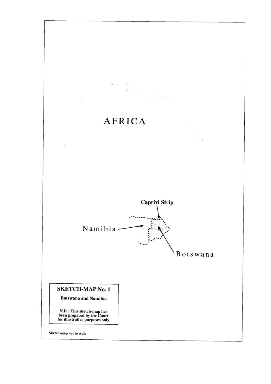
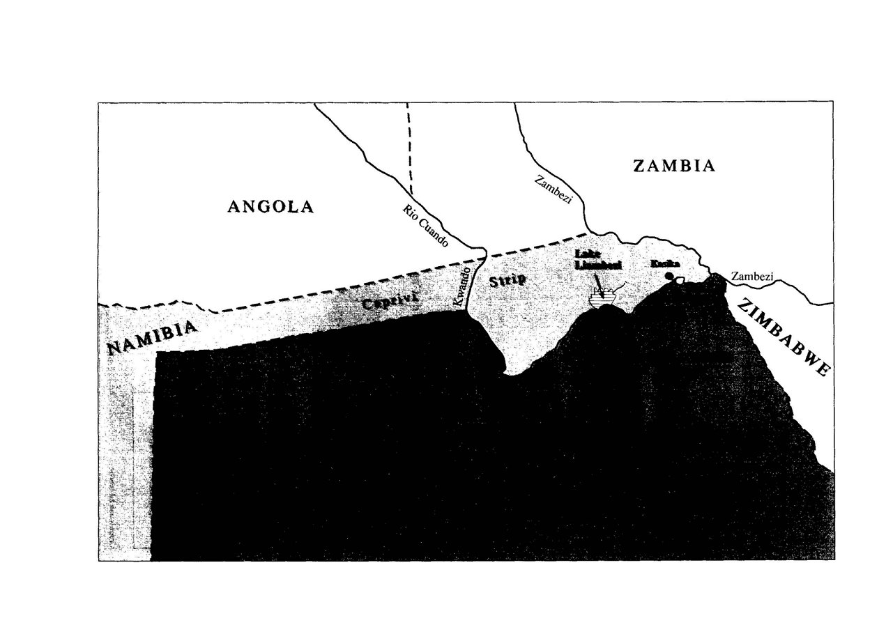
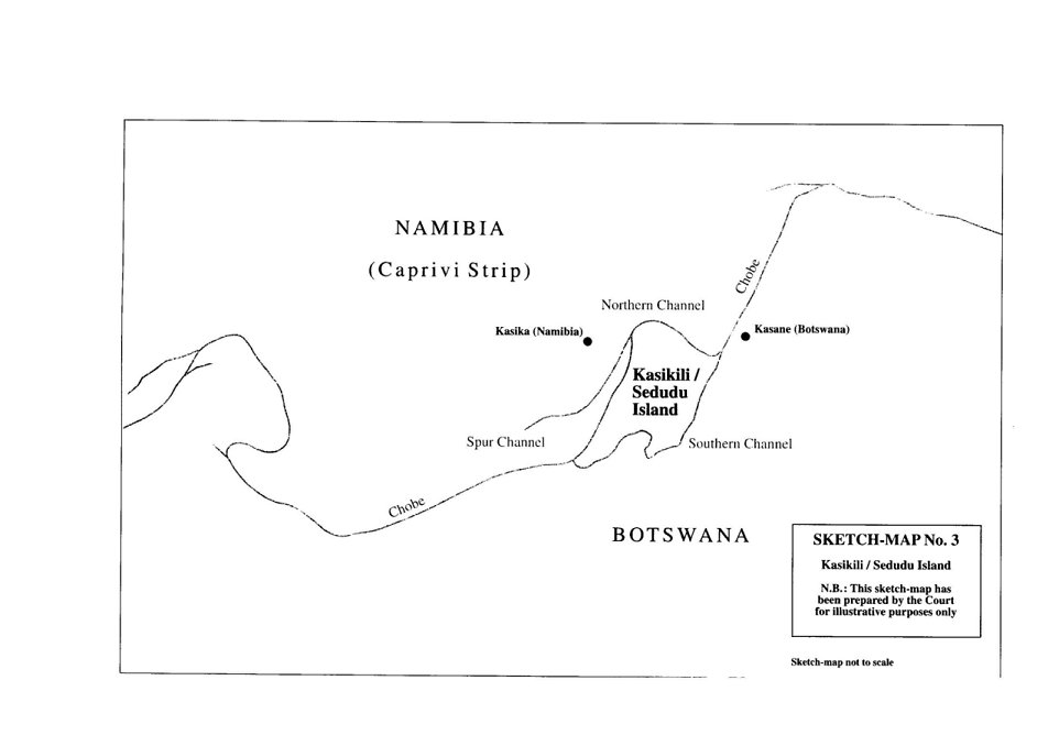
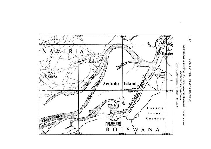