| |
[p355] The CHAMBER OF THE INTERNATIONAL COURT OF JUSTICE formed to deal
with the above-mentioned case,
composed as above,
after deliberation,
delivers the following Judgment: [p356]
1. By a joint notification dated 11 December 1986, filed in the Registry of
the Court the same day, the Ministers for Foreign Affairs of the Republic of
Honduras and the Republic of El Salvador transmitted to the Registrar a
certified copy of a Special Agreement in the Spanish language entitled "COMPROMISO
ENTRE HONDURAS Y EL SALVADOR PARA SOMETER A LA DECISION DE LA CORTE
INTERNACIONAL DE JUSTICIA LA CONTROVERSIA FRONTERIZA TERRESTRE, INSULAR Y
MARITIMA EXISTENTE ENTRE LOS DOS ESTADOS, SUSCRITO EN LA CIUDAD DE
ESQUIPULAS, REPUBLICA DE GUATEM ALA, EL DIA 24 DE MAYO DE 1986 “; and
entering into force on 1 October 1986.
2. The Parties provided the Chamber with a joint translation into English of
this Special Agreement under cover of a letter dated 2 May 1991, received in
the Registry on 8 May 1991. A French translation of the agreed English
translation of the Special Agreement was prepared by the Registry.
3. The Spanish text of the Special Agreement of 24 May 1986 was set out in
the Judgment of the Chamber dated 13 September 1990 on the application of
Nicaragua to intervene in the case (see paragraph 12 below). The agreed
English translation of the Special Agreement is as follows:
"SPECIAL AGREEMENT BETWEEN EL SALVADOR AND HONDURAS TO SUBMIT TO THE
DECISION OF THE INTERNATIONAL COURT OF JUSTICE THE LAND, ISLAND AND MARITIME
BOUNDARY DISPUTE EXISTING BETWEEN THE TWO STATES, SIGNED IN THE CITY OF
ESQUIPULAS, REPUBLIC OF GUATEMALA, ON 24 MAY 1986.
The Government of the Republic of El Salvador and the Government of the
Republic of Honduras,
Considering that on 30 October 1980, in the City of Lima, Peru, they signed
the General Treaty of Peace, by means of which, inter alia, they delimited
the land boundary of both Republics in those sectors where there did not
exist any dispute;
Considering that within the period of time envisaged by Articles 19 and 31
of the General Treaty of Peace, of 30 October 1980, no direct agreement was
reached regarding the differences relating to the existing boundaries in
respect of the remaining land areas in dispute and relating to the juridical
status of the islands and of the maritime spaces;
Have designated as their respective Plenipotentiaries, El Salvador its
Minister of Foreign Affairs, Licenciado Rodolfo Antonio Castillo Claramount,
and Honduras its Minister of Foreign Affairs, the lawyer Carlos López
Contreras, who having found their Full Powers to be in good and appropriate
form:
AGREE THE FOLLOWING:
Article 1
Constitution of a Chamber
1. In application of Article 34 of the General Treaty of Peace, signed on 30
October 1980, the Parties submit the issues mentioned in Article 2 of the
present Special Agreement to a chamber of the International Court of
Justice, composed of three members, with the consent of the Parties, who
will express this in a joint form to the President of the Court, this
agreement [p357] being essential for the formation of the chamber, which
will be constituted in accordance with the procedures established in the
Statute of the Court and in the present Special Agreement.
2. In addition the chamber will include two Judges ad hoc specially
nominated one by El Salvador and the other by Honduras, who may have the
nationality of the Parties.
Article 2
Subject of the Litigation
The Parties request the Chamber:
1. To delimit the boundary line in the zones or sections not described in
Article 16 of the General Treaty of Peace of 30 October 1980.
2. To determine the legal situation of the islands and maritime spaces.
Article 3
Procedure
1. The Parties request the Chamber to authorize that the written proceedings
shall consist of:
(a) a Memorial presented by each of the Parties not later than ten months
after the notification of this Special Agreement to the Registry of the
International Court of Justice;
(b) a Counter-Memorial presented by each of the Parties not later than ten
months after the date on which each has received the certified copy of the
Memorial of the other Party;
(c) a Reply presented by each of the Parties not later than ten months after
the date on which each has received the certified copy of the
Counter-Memorial of the other Party;
(d) the Court will be able to authorize or to prescribe the presentation of
a Rejoinder, if the Parties so agree or if the Court decides ex officio or
at the request of one of the Parties that this part of the proceedings is
necessary.
2. The above-mentioned parts of the written proceedings and their annexes
presented to the Registrar will not be transmitted to the other Party until
the Registrar has received the part of the proceedings corresponding to the
said Party.
3. The oral procedure, the notification of the appointment of the respective
Agents of the Parties, and any other procedural questions will be regulated
in accordance with the provisions of the Statute and the Rules of the Court.
Article 4
Languages
The case will be heard in the English and French languages without
distinction.
Article 5
Applicable Law
In accordance with the provisions of the first paragraph of Article 38 of
the Statute of the International Court of Justice, the Chamber, when
delivering its Judgment, will take into account the rules of international
law [p358] applicable between the Parties, including, where pertinent, the
provisions of the General Treaty of Peace.
Article 6
Execution of the Judgment
1. The Parties will execute the Judgment of the Chamber in its entirety and
in complete good faith. To this end, the Special Demarcation Commission
established by the Agreement of 11 February 1986 will begin the demarcation
of the frontier line fixed by the Judgment not later than three months after
the date of the said Judgment and will diligently continue its work until
the demarcation is completed.
2. For this purpose, the procedures established in respect of this matter in
the above-mentioned Agreement concerning the establishment of the Special
Demarcation Commission will be applied.
Article 7
Entry into Force and Registration
1. This present Special Agreement will enter into force on 1 October 1986,
once the constitutional requirements of each Party have been met.
2. It will be registered with the Secretary-General of the United Nations in
accordance with Article 102 of the United Nations Charter, jointly or by
either of the Parties. At the same time it will be brought to the attention
of the Organization of American States.
Article 8
Notification
1. In application of Article 40 of the Statute of the International Court of
Justice, this present Special Agreement will be notified to the Registrar of
the same by a Joint Note of the Parties. This notification will be made
before 31 December 1986.
2.If this notification is not made in accordance with the preceding
paragraph, the present Special Agreement may be notified to the Registrar of
the Court by either of the Parties within the period one month following the
date established in the preceding paragraph.
In witness thereof, the undersigned sign the present Special Agreement in
two copies in the City of Esquipulas, Republic of Guatemala, on the
twenty-fourth day of May one thousand nine hundred and eighty-six."
4. Pursuant to Article 40, paragraph 3, of the Statute of the Court and
Article 42 of the Rules of Court, copies of the joint notification and
Special Agreement were transmitted by the Registrar to the Secretary-General
of the United Nations, the Members of the United Nations and other States
entitled to appear before the Court. On 30 July 1991, the Registrar also
transmitted copies,
through the same channel, of the English translation approved by the Parties
and of the French translation, prepared by the Registry.
5. The Parties, when duly consulted on 17 February 1987, pursuant to Article
26, paragraph 2, of the Statute and Article 17, paragraph 2, of the Rules of
Court, as to the composition of the chamber of the Court, confirmed what was
[p359] said in the Special Agreement, that as regards the number of judges
to constitute such chamber, they agreed, pursuant to Article 26 of the
Statute, that that number be fixed at three judges with the addition of two
judges ad hoc chosen by the Parties pursuant to Article 31, paragraph 3, of
the Statute.
6. In March 1987 the Court was notified of the choice by El Salvador of Mr.
Nicolas Valticos to sit as judge ad hoc in the chamber; in April 1987, the
Court was notified of the choice by Honduras of Mr. Michel Virally to sit as
judge ad hoc in the chamber.
7. By an Order of 8 May 1987 the Court decided to accede to the request of
the Parties to form a special chamber to deal with the case, and declared
that at an election held on 4 May 1987 Judges Oda, Sette-Camara and Sir
Robert Jennings had been elected to form, with the judges ad hoc referred to
above, a chamber to deal with the case, and declared further such a chamber
to have been duly constituted, with the following composition: Judges Oda,
Sette-Camara and Sir Robert Jennings and Judges ad hoc Valticos and Virally.
On 29 May 1987 the Chamber elected Judge Sette-Camara as its President,
pursuant to Article 18, paragraph 2, of the Rules of Court.
8. Judge ad hoc Virally died on 27 January 1989, and by a letter dated 8
February 1989 the Agent of Honduras informed the Court that his Government
had chosen Mr. Santiago Torres Bernardez to sit as judge ad hoc in his
place. By an Order dated 13 December 1989 the Court declared the composition
of the Chamber formed to deal with the case to be as follows: Judge
Sette-Camara, President of the Chamber; Judges Oda and Sir Robert Jennings;
Judges ad hoc Valticos and Torres Bernerdez.
9. By an Order dated 27 May 1987, the Court, taking into account Article 3,
paragraph 1, of the Special Agreement, fixed the time-limit for Memorials,
and by an Order dated 29 May 1987 the Chamber authorized the filing of
Counter-Memorials and Replies pursuant to Article 92, paragraph 2, of the
Rules of Court, and fixed time-limits therefor.
10. The Memorials were duly filed within the time-limit of 1 June 1988 fixed
therefor. The time-limits for the remaining pleadings were, at the request
of the Parties, extended by Orders made by the President of the Chamber on
12 January 1989 and 13 December 1989. The Counter-Memorials and the Replies
were duly filed within the extended time-limits thus fixed, namely 10
February 1989 and 12 January 1990 respectively.
11. Pursuant to Article 53, paragraph 1, of the Rules of Court, requests by
the Governments of Nicaragua and Colombia for the pleadings and annexed
documents to be made available to them were granted, for Nicaragua on 15
June 1988, and for Colombia on 27 January 1989, and in each case after the
views of the Parties had been ascertained.
12. On 17 November 1989 the Republic of Nicaragua filed in the Registry of
the Court an Application for permission to intervene in the case, which
Application was stated to be made by virtue of Article 36, paragraph 1, and
Article 62 of the Statute of the Court. In that Application, the Government
of Nicaragua contended that its request for permission to intervene, "not
only because it is an incidental proceeding but also for... reasons of
elemental equity (that of consent and that of the equality of States)", was
"a matter exclusively within the procedural mandate of the full Court"
.
13. By an Order dated 28 February 1990, the Court, after considering the
written observations of the Parties on the question thus raised, whether the
Application for permission to intervene was to be decided upon by the full
[p360] Court or by the Chamber, and the observations of Nicaragua in
response to those observations found that it was for the Chamber formed to
deal with the present case to decide whether the Application by Nicaragua
for permission to intervene under Article 62 of the Statute should be
granted.
14. Pursuant to Article 83, paragraph 1, of the Rules of Court, the two
Parties on 5 March 1990 submitted written observations on the Application
for permission to intervene filed by Nicaragua on 17 November 1989; since in
the observations of El Salvador objection was made to the Application for
permission to intervene, public sittings were held, pursuant to Article 84,
paragraph 2, of the Rules of Court, in order to hear the State seeking to
intervene and the Parties,
on 5, 6, 7 and 8 June 1990.
15. By a Judgment delivered on 13 September 1990 the Chamber found that
Nicaragua had shown that it had an interest of a legal nature which may be
affected by part of the Judgment of the Chamber on the merits in the present
case, namely its decision on the legal regime of the waters of the Gulf of
Fonseca, but not by its decision on other issues in dispute, and decided
that Nicaragua was permitted to intervene in the case, but not as a Party,
pursuant to Article 62 of the Statute, to the extent, in the manner and for
the purposes therein indicated, but not further or otherwise.
16. Since the Application for permission to intervene submitted by Nicaragua
had to that extent been granted by the Chamber, in accordance with Article
85 of the Rules of Court, that State submitted a written statement and the
Parties filed written observations thereon. The written statement of
Nicaragua and the written observations of the Parties thereon were filed
within the time-limits fixed by the President of the Chamber.
17. The President of the Chamber fixed 15 April 1991 as the time-limit for
the opening of the oral proceedings in the case. Following consultations
with the representatives of the Parties on 21 February 1991, it was decided
that the Parties would present their arguments successively on each of the
following aspects of the dispute: (a) the whole of the general question; (b)
each of the
six sectors of the land frontier; (c)the islands and maritime spaces.
Following a meeting held, after the opening of the oral proceedings, between
the President of the Chamber and the Agents of the Parties and of the
intervening State, it was agreed that, after the Parties had presented their
arguments on the legal regime of the maritime spaces within the Gulf of
Fonseca, Nicaragua would address this question and could, after the Parties
had presented their views on the whole of the maritime aspects of the
dispute, make a final statement on the legal regime of the waters of the
Gulf of Fonseca.
18. In the course of 50 public sittings, held from 15 April to 14 June 1991,
the Chamber was addressed by the following representatives of the Parties
and Nicaragua:
For the Republic of Honduras: H.E. Mr. Ramon Valladares Soto,
Mr. Paul De Visscher,
Mr. Alejandro Nieto,
Mr. Daniel Bardonnet,
Mr. Luis Ignacio Sanchez Rodnguez,
Mr. Julio Gonzalez Campos,
Mr. Rene-Jean Dupuy,
Mr. Pierre-Marie Dupuy,
Mr. Derek Bowett, Q.C.
[p361]
For the Republic of El Salvador: H.E. Mr. Jose Manuel Pacas Castro,
H.E. Mr. Alfredo Martinez Moreno,
Mr. Prosper Weil,
Mr. Eduardo Jimenez de Arechaga,
Mr. Anthony J. Oakley,
Mr. Francisco Roberto Lima,
Mr. Keith Highet,
Mr. Elihu Lauterpacht, Q.C.
For the Republic of Nicaragua: H.E. Mr. Carlos Argüello Gomez,
Mr. Ian Brownlie, Q.C.,
H.E. Mr. Enrique Dreyfus Morales.
19. In accordance with Article 53, paragraph 2, of the Rules of Court, the
Court decided that copies of the pleadings and documents annexed would be
made accessible to the public on the opening of the oral proceedings.
20. On 12 April 1991 the Republic of El Salvador indicated, in accordance
with Article 57 of the Rules of Court, that it intended to call Mr.
Heriberto Aviles Dominguez, of Salvadorian nationality, as a witness and
provided particulars identifying him. Additional information concerning Mr.
Aviles Dominguez was communicated subsequently by El Salvador, at the
request of the Agent of Honduras. At a public sitting held on 29 May 1991
Mr. Aviles Dominguez gave evidence, in Spanish, and in accordance with
Article 39, paragraph 3, of the Statute and Article 70, paragraph 2, of the
Rules of Court, El Salvador made the necessary arrangements for the
statement of its witness to be interpreted. The examination-in-chief of the
Salvadorian witness was conducted by Mr. Highet and the cross-examination by
Mr. Sanchez Rodriguez.
21. In the course of the oral proceedings, a number of new documents were
submitted by each of the Parties in accordance with Article 56, paragraph 1,
of the Rules of Court. Prior to the close of the oral proceedings El
Salvador announced its intention of submitting to the Chamber certain
additional documents which had been referred to, but not included, in a
dossier of documents concerning the island dispute (referred to as the "Meanguera
dossier") submitted by El Salvador during the oral proceedings. These
additional documents were transmitted to the Chamber under cover of a letter
from the Agent of El Salvador dated 5 September 1991. The President of the
Chamber, while noting that the submission of further documents to the Court
after the closure of the written proceedings was not a normal part of the
procedure, took the view that it was appropriate to apply to them, by
extension and mutatis mutandis, the provision of Article 56 of the Rules. A
set of copies of the documents was therefore transmitted to Honduras, which
objected to the admission of the additional documents submitted by El
Salvador. After examining the question the Chamber decided not to authorize
the submission of those documents and informed the Parties of its decision
to that effect.
22. At the hearings of 27 May 1991 and 14 June 1991, El Salvador requested
that the Chamber consider exercising its functions pursuant to Article 66 of
the Rules of Court with regard to the obtaining of evidence in situ in the
disputed areas of the land frontier, and indicated also that El Salvador
would welcome any order by the Chamber pursuant to Article 67 of the Rules,
arranging for an enquiry or an expert opinion on these matters. At the
closure of the oral proceedings, the President of the Chamber stated that
the Chamber considered that it was not yet in a position to reach a decision
on whether it would be appropri[p362]ate in the case to exercise its powers
under Articles 66 and 67 of the Rules of Court, and would announce its
decision in due course. After deliberation, the Chamber decided that it did
not consider it necessary to exercise its functions with regard to the
obtaining of evidence, as contemplated by Article 66 of the Rules of Court,
in the disputed areas of the land frontier, as suggested by El Salvador, nor
did it consider it necessary to exercise its powers to arrange for an
enquiry or expert opinion in the case.
23. In the course of the written proceedings the following submissions were
presented by the Parties:
On behalf of the Republic of El Salvador,
in the Memorial:
"I. Delimitation of the Land Frontier
The Government of El Salvador requests the Chamber of the International
Court of Justice to delimit the land frontier in the disputed areas between
El Salvador and Honduras on the basis of:
1. The rights resulting from the titles to commons owned in favour of El
Salvador and the effective sovereignty that El Salvador has exercised and
exercises in those disputed areas in accordance with the evidence which has
been submitted in the annexes of the present Memorial. The precise
delimitation of the areas which, in accordance with the above are subject to
its sovereignty are set out as follows:"
In the Memorial, here follow references to the specific paragraphs of the
Memorial setting out the argument of El Salvador on each of the six sectors
of the land boundary. The Memorial also contains a "Conclusion" specifying
the detailed course of the line, the terms of which were repeated in the
Annexes to the final submissions of El Salvador at the close of the oral
proceedings (see below).
"2. The addition to the areas thus attributed to El Salvador of those areas
of Crown Lands (tierras realengas) lying between the Common Lands of El
Salvador and Honduras respectively that are properly attributed to El
Salvador after a comparison of the grants of Common Lands made by the
Spanish Crown and authorities in favour of the Provinces of San Salvador and
of Comayagua and Tegucigalpa, Honduras.
II. The Juridical Position of the Islands
The Government of El Salvador requests the Chamber of the International
Court of Justice: To determine, on the basis of long-established possession
and/or of the titles granted by the Spanish Crown, that El Salvador has and
had sovereignty over al1 the islands in the Gulf of Fonseca, with the
exception of the Island of Zacate Grande which can be considered as forming
part of the Coast of Honduras.
III. The Juridical Position of the Maritime Spaces
The Government of El Salvador requests the Chamber of the International
Court of Justice to determine the juridical position of the maritime spaces
as follows: [p363]
A. Within the Gulf of Fonseca
The juridical position of the maritime spaces within the Gulf of Fonseca
corresponds to the juridical position established by the Judgement of the
Central American Court of Justice rendered 9 March 1917, as accepted and
applied thereafter.
B. Outside of the Gulf of Fonseca
As regards the juridical position beyond the closing line of the Gulf of
Fonseca, the Government of El Salvador is unaware of the precise nature and
extent of the claim, if any, of the Government of Honduras and must,
therefore reserve its position. However El Salvador maintains that in
principle, as Honduras has no Coast on the Pacific Ocean, it has no rights
in that ocean other than those possessed therein by any other non-littoral
State."
in the Counter-Memorial:
"I. Delimitation of the Land Frontier
1. The Government of El Salvador ratifies the petition to the Chamber of the
International Court of Justice contained in its Memorial that the Chamber
delimit the land frontier between El Salvador and Honduras in the disputed
sectors in accordance with the line indicated in the submissions contained
in the Memorial of El Salvador.
2. In addition to the arguments set out in the Memorial of El Salvador, the
Government of El Salvador has proven:
(i) that the land boundaries defined by the Formal Title-Deeds to the
Commons of the indigenous communities (which include the Roval Landholdings
within the same jurisdictions) presented by El Salvador are absolutely
identical with the international frontiers of the territory of each State;
(ii) that El Salvador has completely established in its Memorial and in this
Counter-Memorial that the Formal Title-Deeds to Commons which support the
claims of El Salvador were executed by the Spanish Crown in accordance with
all the necessary judicial procedures and requirements and, consequently,
these Formal Title-Deeds to Commons form the fundamental basis of the uti
possidetis juris in that they indicate jurisdictionl boundaries, that is to
Say the boundaries of territories and Settlements;
(iii) that Honduras has presented Title-Deeds to private proprietary
interests which in no case either permitted the exercise of administrative
control or implied the exercise of acts of sovereignty;
(iv) that the majority of the Title-Deeds presented by Honduras relate to
lands which are situated either outside the disputed sectors or in sectors
which have already been delimited by the General Peace Treaty of 1980.
II. The Juridical Status of the Islands
3. The Government of El Salvador ratifies the petition to the Chamber of the
International Court of Justice contained in its Memorial in view of the fact
that in Chapters V and VI of this Counter-Memorial it has rebutted the
arguments contained in the Memorial of Honduras. [p364]
4. In addition to the arguments set out in the Memorial of El Salvador, the
Government of El Salvador has proven:
(i) that in 1804 none of the islands of the Gulf of Fonseca was assigned to
the Bishopric of Comayagua and that, even when the 'Alcaldia Mayor' of
Tegucigalpa was incorporated to the intendency and Government of Comayagua
subsequently to 1821, neither this ' Alcaldia' nor the Bishopric of
Comayagua ever exercised either civil or ecclesiastical jurisdiction over
the islands of the Gulf of Fonseca during the colonial period and thus it
was the colonial Province of San Salvador, through San Miguel, that
exercised both civil and ecclesiastical jurisdiction over the islands of the
Gulf of Fonseca;
(ii) that the colonial Province of Honduras, when it was constituted, did
not have any coast on the Pacific Ocean;
(iii) that the Reales Cedulas (Royal Decrees) of 1563 and 1564 left the Gulf
of Fonseca within the jurisdiction of the Captain-General of Guatemala and,
more specifically, in the jurisdiction of San Miguel in the colonial
Province of San Salvador;
(iv) that when the Spanish Crown established jurisdiction over islands, it
did so by means of a Real Cedula (as in the case of islands of Guanajas on
the Atlantic coast of Honduras) and no such Real Cedula was ever executed in
favour of Honduras in respect of the Islands of the Gulf of Fonseca.
III. The Juridical Status of the Maritime Spaces
5. The Government of El Salvador petitions the Chamber of the International
Court of Justice that it determine the juridical status of the maritime
spaces in the following manner:
(i) that, in view of the Principles of the Law of the Sea, it apply within
the Gulf of Fonseca the juridical status established by the decision of the
Central American Court of Justice handed down on 9 March 1917;
(ii) that, in accordance with the Special Agreement between El Salvador and
Honduras, it decide that it has no jurisdiction to delimit the waters of the
Gulf of Fonseca;
(iii) that it decline to delimit the maritime spaces outside the Gulf of
Fonseca in the Pacific Ocean beyond the closing line of the Gulf on the
grounds that its jurisdiction is limited to determining the juridical status
of these maritime spaces;
(iv) that it determine that the rights and the jurisdiction over the waters
and maritime spaces (including the natural resources therein) of the Pacific
Ocean beyond the closing line of the Gulf of Fonseca are exerciseable
exclusively by El Salvador and Nicaragua on the grounds that such rights
arise from the relevant coasts which these two States have on the Pacific
Ocean";
in the Reply:
"I. Delimitation of the Land Frontier
1. The Government of El Salvador ratifies the petition to the Chamber of the
International Court of Justice contained in its Memorial that the Chamber
delimit the land frontier between El Salvador and Honduras in the disputed
sectors in accordance with the line indicated in the submissions contained
in the Memorial. This petition was ratified in the [p365] Counter-Memorial
of El Salvador, which rebutted the arguments contained in the Memorial of
Honduras, and is now ratified again in view of the fact that in Chapters II,
III and IV of this Reply El Salvador has rebutted the arguments contained in
the Counter-Memorial of Honduras.
II. The Juridical Status of the Islands
2. The Government of El Salvador ratifies the petition to the Chamber of the
International Court of Justice contained in its Memorial as to the juridical
status of the islands. This petition was ratified in the Counter-Memorial of
El Salvador, which rebutted the arguments contained in the Memorial of
Honduras, and is now ratified again in view of the fact that in Chapter V of
this Reply El Salvador has rebutted the arguments contained in the
Counter-Memorial of Honduras.
III. The Juridical Status of the Maritime Spaces
3. The Government of El Salvador ratifies the position to the Chamber of the
International Court of Justice contained in its Counter-Memorial as to the
juridical status of the maritime spaces in view of the fact that in Chapter
VI of this Reply El Salvador has rebutted the arguments contained in the
Counter-Memorial of Honduras."
On behalf of the Republic of Honduras,
in the Memorial and in the Counter-Memorial (identical texts):
"In view of the facts and arguments set out above, the Government of the
Republic of Honduras confirms and reiterates the submissions of its Memorial
and asks that it may please the Court:
A. With respect to the land frontier dispute:
— to adjudge and declare that the course of the frontier between El Salvador
and Honduras is constituted by the following line in the areas or sections
not described in Article 16 of the General Peace Treaty of 30 October 1980:
1. Section of the land frontier lying between the point known as El Trifinio,
at the summit of the Cerro Montecristo, and the summit of the Cerro del
Zapotal. From the summit of the Cerro Montecristo (latitude 14° 25' 20" N
and longitude 89° 21' 28" W), the tripoint between Honduras, El Salvador and
Guatemala, running south-east to the northernmost source of the San Miguel
Ingenio or Taguilapa river (14° 24' 00" N and 89° 20' 10" W), known as the
Chicotera, thereafter running downstream along the middle of the bed of the
said river to the ford on the road from Citala to Metapan (14° 20' 55" N and
89° 19' 33" W) at Las Cruces. From the preceding point eastwards, in a
straight line, as far as the confluence of the river Jupula with the river
Lempa (14° 21' 06" N and 89° 13' 10" W), the said line passing through the
place known as El Cobre, and from that confluence in a straight line to the
summit of the Cerro del Zapotal (14° 23' 26" N and 89° 14' 43" W).
2.Section of the land frontier lying between the Cayaguanca rock and the
confluence of the Chiquita or Oscura Stream with the Sumpul [p366] river.
From the Cayaguanca rock (14° 21' 55" N and 89° 10' 05" W), in a straight
line, as far as the confluence of the Chiquita or Oscura rnountain stream
with the river Sumpul (14° 20' 25" N and 89° 04' 57" W).
3. Section of the land frontier lying between the Pacacio boundary marker
and the boundary marker known as Poza del Cajon. From the Pacacio boundary
marker(14° 06'28" N and 88° 49'20" W), on the river of the same name, in a
straight line as far as the confluence of the La Puerta stream with the
Gualcinga river (14° 06' 24" N and 88° 47' 04’’ W) and from there downstream
along the middle of the bed of the said river to arrive at the Poza del Toro
boundary marker (14° 04' 14" N and 88° 47' 00" W), at the confluence of the
river Gualcinga with the river Sazalapa, on La Lagartera, thence following
the said river upstream along the middle of the bed to the Poza de la
Golondrina boundary marker (14° 06' 55" N and 88° 44' 32" W); from this
point in a straight line as far as the La Canada, Guanacaste or Platanar
boundary marker (14° 06'04" N and 88° 43' 52" W) and from that boundary
marker in a straight line to the El Portillo boundary marker on the Cerro
del Tambor (14° 04' 47" N and 88" 44' 06 W), also known as Portillo de El
Sapo; from that boundary marker in a straight line as far as the Guaupa
boundary marker (14° 04' 33" N and 88° 44' 40" W), passing over the El Sapo
hill; thence in a straight line to the summit of the Lorna Redonda (14° 03'
46" N and 88° 44' 35" W); from the Lorna Redonda in a straight line to the
summit of the Cerro del Ocotillo or Gualcimaca (14° 03' 25" N and 88° 44'
22" W), passing over the Cerro del Caracol. From the El Ocotillo boundary
marker, in a straight line, as far as the La Barranca or Barranco Blanco
boundary marker (14° 02' 55" N and 88° 43' 27" W); from there to the Cerro
de la Bolsa (14° 02' 05" N and 88° 42' 40" W); and from that place, in a
straight line, to the Poza del Cajon boundary marker(14° 01' 28" N and 88°
41' 10" W) on the river Arnatillo or Gualcuquin.
4. Section of the land frontier lying between the source of the La Orilla
stream and the boundary marker known as the Malpaso de Similaton. From the
source of the mountain stream called La Orilla (13° 53' 50" N and 88° 20'
30" W) to the pass of El Jobo (13° 53' 40" N and 88° 20' 25" W), at the foot
of the mountain known as El Volcancillo; from there to the southernmost
source of the Cueva Hedionda (13° 53' 46" N and 88° 20' 00" W), following
its course downstream along the middle of the bed to the Charnpate boundary
marker (13° 53' 20" N and 88° 19' 02" W) as far as its confluence with the
river Canas or Santa Ana, thence following the camino real, by way of the
boundary markers of Portillo Blanco (13° 53' 40" N and 88° 18' 24" W),
Obrajito (13° 53' 50" N and 88° 17' 28" W), Laguna Seca (13° 54' 03" N and
88° 16' 46" W), Arnatillo (13° 54' 28" N and 88° 15' 42" W), Picacho or
Quecruz (13° 55' 59" N and 88° 14' 42" W), Esquinero or Sirin (13° 56' 55" N
and 88° 13' 10" W), El Carrizal (13° 57' 20" N and 88° 11'35" W); thence,
still following the camino real, as far as the point where this road crosses
the river Negro (13° 59' 36" N and 88° 12' 35" W); thence, following the
river Negro upstream, as far as the Las Pilas boundary marker at the source
of that same river [p367] (14° 00' 00" N and 88° 06' 30" W), and from that
place to the Malpaso de Similaton (13° 59' 28" N and 88° 04' 21" W).
5. Section of the land frontier lying between the point where the river
Torola is joined by the Manzupucagua stream and the ford known as Paso de
Unire. From the confluence of the Manzupucagua mountain stream with the
Torola river (13° 54' 00" N and 87° 54' 30" W), following the river Torola
upstream along the middle of the bed to its source, the mountain stream
known as La Guacamaya (13° 53' 30" N and 87° 48' 22" W); from this point, in
a straight line, to the pass of La Guacamaya (13° 53' 20" N and 87° 48' 19"
W); thence in a straight line to a point on the river Unire (13° 52' 37" N
and 87° 47' 04" W), close to the place known as El Coyolar, and from there,
following the Unire river downstream, as far as the Paso de Unire or Limon
ford (13° 52' 07" N and 87° 46' 00" W), on the said river.
6. Section of the land frontier lying between Los Amates and the Gulf of
Fonseca. From the point known as Los Amates on the river Goascoran (13° 26'
28" N and 87° 43' 20" W), following the said river downstream along the
middle of the bed by way of the Rincon de Muruhuaca and Barrancones, as far
as its mouth to the north-west of the Ramaditas islands (13° 24' 26" N and
87° 49' 05" W) in the Bay of La Union.
B. With respect to the island dispute:
— to declare that the Republic of Honduras has sovereignty over the islands
of Meanguera and Meanguerita.
Ń With respect to the maritime dispute:
(1) Concerning the zone subject to delimitation within the Gulf:
— to adjudge and declare that the community of interests existing between El
Salvador and Honduras by reason of their both being coastal States bordering
on an enclosed historic bay produces between them a perfect equality of
rights, which has nevertheless never been transformed by the same States
into a condominium;
— to adjudge and declare, therefore, that each of the two States is entitled
to exercise its powers within zones to be precisely delimited between El
Salvador and Honduras;
— to adjudge and declare that the course of the line delimiting the zones
falling, within the Gulf, under the jurisdiction of Honduras and El Salvador
respectively, taking into account all the relevant circumstances for the
purpose of arriving at an equitable solution, shall be defined as
follows:
(a) the line equidistant from the low-water line of the mainland and island
coasts of the two States, starting within the Bay of La Union, from the
mouth of the Rio Goascoran (latitude 13° 24' 26" N and longitude 87° 49' 05"
W) and extending to the point situated at a distance of 1 nautical mile from
the Salvadorian island of Con-[p368]chaguita and from the Honduran island
of Meanguera, to the south of the first and to the West of the second;
(b) from that point, the line joining points situated at a distance of 1
nautical mile from the island of Conchaguita, running to the south of that
island up to a point situated at a distance of 3 nautical miles from the
mainland coast of El Salvador;
(c) from that point onwards, the line joining points situated at a distance
of 3 nautical miles from the Salvadorian coast as far as the point where it
meets the closing line of the Gulf (see illustrative Chart CS);
— to adjudge and declare that the community of interests existing between El
Salvador and Honduras as coastal States bordering on the Gulf implies an
equal right for both to exercise their jurisdictions over maritime areas
situated beyond the closing line of the Gulf.
(2) Concerning the zone outside the Gulf:
—to adjudge and declare that the delimitation line productive of an
equitable solution, when account is taken of al1 the relevant circumstances,
is represented by a line drawn on a bearing of 215.5°, starting from the
closing line of the Gulf at a point situated at a distance of 3 nautical
miles from the coast of El Salvador, and running out 200 nautical miles from
that point, thus delimiting the territorial sea, exclusive economic zone and
continental shelf of El Salvador and Honduras (see illustrative Chart C.6)";
in the Reply:
"In view of the facts and arguments set out above, the Government of the
Republic of Honduras asks that it may please the Court:
A. With respect to the land frontier dispute:
— to adjudge and declare that the course of the frontier between El Salvador
and Honduras is constituted by the following line in the areas or sections
not described in Article 16 of the General Peace Treaty of 30 October 1980:
1. Section of the land frontier lying between the point known as El Trifinio,
at the summit of the Cerro Montecristo, and the summit of the Cerro del
Zapotal. From the summit of the Cerro Montecristo (latitude 14" 25' 20" N
and longitude 89" 21' 28" W), the tripoint between Honduras, El Salvador and
Guatemala, running south-east to the northernmost source of the San Miguel
Ingenio or Taguilapa river (14° 24' 00" N and 89° 20' 10" W), known as the
Chicotera, thereafter running downstream along the middle of the bed of the
said river to the ford on the road from Citala to Metapan (14° 20' 55" N and
89° 19' 33" W) at Las Cruces. From the preceding point eastwards, in a
straight line, as far as the confluence of the river Jupula with the river
Lempa (14° 21' 06" N and 89° 13' 10" W), the said line passing through the
place known as El Cobre, and from that confluence in a straight line to the
summit of the Cerro Zapotal (14° 23' 26" N and 89° 14' 43" W).
2. Section of the land frontier lying between the Cayaguanca rock and the
confluence of the Chiquita or Oscura Stream with the Sumpul [p369] river.
From the Cayaguanca rock (14° 21' 55" N and 89° 10' 05" W), in a straight
line, as far as the confluence of the Chiquita or Oscura mountain stream
with the river Sumpul (l4° 20' 25" N and 89° 04' 57" W).
3. Section of the land frontier lying between the Pacacio boundary marker
and the boundary marker known as Poza del Cajon. From the Pacacio boundary
marker (14° 06' 28" N and 88° 49' 20 W), on the river of the same name, in a
straight line as far as the confluence of the La Puerta stream with the
Gualcinga river (14° 06' 24" N and 88° 47' 04" W) and from there downstream
along the middle of the bed of the said river to arrive at the Poza del Toro
boundary marker (14° 04' 14" N and 88° 47' 00" W), at the confluence of the
river Gualcinga with the river Sazalapa, on La Lagartera, thence following
the said river upstream along the middle of the bed to the Poza de la
Golondrina boundary marker (14° 06' 55" N and 88° 44' 32" W); from this
point in a straight line as far as the La Canada, Guanacaste or Platanar
boundary marker (14° 06' 04" N and 88° 43' 52" W) and from that boundary
marker in a straight line to the El Portillo boundary marker on the Cerro
del Tambor (14° 04' 47" N and 88° 44' 06" W), also known as Portillo de El
Sapo; from that boundary marker in a straight line as far as the Guaupa
boundary marker (14° 04' 33" N and 88° 44' 40" W), passing over the El Sapo
hill; thence in a straight line to the summit of the Loma Redonda (14° 03'
46" N and 88° 44' 35" W); from the Loma Redonda in a straight line to the
summit of the Cerro del Ocotillo or Gualcimaca (14° 03' 25" N and 88° 44'
22" W), passing over the Cerro del Caracol. From the El Ocotillo boundary
marker, in a straight line, as far as the La Barranca or Barranco Blanco
boundary marker (14° 02' 55" N and 88° 43' 27" W); from there to the Cerro
de la Bolsa (14° 02' 05" N and 88° 42' 40" W); and from that place, in a
straight line, to the Poza del Cajon boundary marker (14° 01' 28" N and 88°
41' 10" W) on the river Amatillo or Gualcuquin.
4. Section of the land frontier lying between the source of the La Orilla
stream and the boundary marker known as the Malpaso de Similaton. From the
source of the mountain stream called La Orilla (13° 53' 50" N and 88° 20'
30" W) to the pass of El Jobo (13° 53' 40" N and 88° 20' 25" W), at the foot
of the mountain known as El Volcancillo; from there to the southernmost
source of the Cueva Hedionda (13° 53' 46" N and 88° 20' 00" W), following
its course downstream along the middle of the bed to the Champate boundary
marker (13° 53' 20" N and 88° 19' 02" W) as far as its confluence with the
river Canas or Santa Ana, thence following the camino real, by way of the
boundary markers of Portillo Blanco (13° 53' 40" N and 88° 18' 24" W),
Obrajito (13° 53' 50" N and 88° 17' 28" W), Laguna Seca (13° 54' 03" N and
88° 16' 46" W), Amatillo or Las Tijeretas (13° 54'28" N and 88° 15' 42" W),
and from there, in a northerly direction, as far as the point at which the
river Las Canas joins the mountain stream known as Masire or Las Tijeretas
(13° 55' 03" N and 88° 15' 45" W); thence, taking a north-easterly
direction, it follows its course upstream as far as the road from Torola to
Colomoncagua and continues in the same direction as far as the Cerro La
Cruz, Quecruz or El Picacho (13° 55' 59" N [p370] and 88° 13' 10" W);
thence, to the Monte Redondo, Esquinero or Sirin boundary marker (13° 56'
55" N and 88° 13' 10" W) and from there to the El Carrisal or Soropay marker
(13° 57' 41" N and 88° 12' 52" W); from there it runs in a northerly
direction to the Cerro del Ocote or hill of Guiriri (13° 59' 00 N and 88°
12' 55" W), and thence, in the same direction, to the marker of El Rincon,
on the river Negro, Quiaguara or El Palmar (13° 59' 53" N and 88° 12' 59"
W); thence, following the river Negro upstream, as far as the Las Pilas
boundary marker at the source of that same river (14° 00' 00" N and 88° 06'
30" W), and from that place to the Malpaso de Similaton (13° 59' 28" N and
88° 04' 21"W).
5. Section of the land frontier lying between the point where the river
Torola is joined by the Manzupucagua stream and the ford known as Paso de
Unire. From the confluence of the Manzupucagua mountain stream with the
Torola river (13° 54' 00" N and 87° 54' 30" W), following the river Torola
upstream along the middle of its bed to its source, the mountain stream
known as La Guacamaya (13° 53' 30" N and 87° 48' 22" W); from this point, in
a straight line, to the pass of La Guacamaya (13° 53' 20" N and 87° 48' 19"
W); thence in a straight line to a point on the river Unire (13° 52' 37" N
and 87° 47' 04" W), close to the place known as El Coyolar, and from there,
following the Unire river downstream, as far as the Paso de Unire or Limon
ford (13° 52' 07" N and 87° 46' 00" W), on the said river.
6. Section of the land frontier lying between Los Amates and the Gulf of
Fonseca. From the point known as Los Arnates on the river Goascoran (13° 26'
28" N and 87° 43' 20" W), following the said river downstream along the
middle of the bed by way of the Rincon de Muruhuaca and Barrancones, as far
as its mouth to the north-west of the Ramaditas islands (13° 24' 26" N and
87° 49'05" W) in the Bay of La Union.
— to reject the submissions of the Government of El Salvador including those
set forth in item 1, paragraph 2, of the submissions of the Counter-Memorial
and that relate to the delimitation of the land frontier;
B. With respect to the island dispute:
— to declare that only the islands of Meanguera and Meanguerita are in
dispute between the Parties and that the Republic of Honduras has
sovereignty over them.
C. With respect to the maritime dispute:
(1) Concerning the zone subject to delimitation within the Gulf:
— to adjudge and declare that the community of interests existing between El
Salvador and Honduras by reason of their both being coastal States bordering
on an enclosed historic bay produces between them a perfect equality of
rights, which has nevertheless never been transformed by the same States
into a condominium; [p371]
— to adjudge and declare, therefore, that each of the two States is entitled
to exercise its powers within zones to be precisely delimited between El
Salvador and Honduras;
—to adjudge and declare that the course of the line delimiting the zones
falling, within the Gulf, under the jurisdiction of Honduras and El Salvador
respectively, taking into account all the relevant circumstances for the
purpose of arriving at an equitable solution, shall be defined as
follows:
(a) the line equidistant from the low-water line of the mainland and island
coasts of the two States, starting within the Bay of La Union, from the
mouth of the Rio Goascoran (latitude 13° 24' 26" N and longitude 87° 49' 05"
W) and extending to the point situated at a distance of 1 nautical mile from
the Salvadorian island of Conchaguita and from the Honduran island of
Meanguera, to the south of the first and to the West of the second;
(b) from that point, the line joining points situated at a distance of 1
nautical mile from the island of Conchaguita, running to the south of that
island up to a point situated at a distance of 3 nautical miles from the
mainland coast of El Salvador;
(c) from that point onwards, the line joining points situated at a distance
of 3 nautical miles from the Salvadorian coast as far as the point where it
meets the closing line of the Gulf (see illustrative chart Ń 5);
— to adjudge and declare that the community of interests existing between El
Salvador and Honduras as coastal States bordering on the Gulf implies an
equal right for both to exercise their jurisdictions over maritime areas
situated beyond the closing line of the Gulf;
(2) Concerning the zone outside the Gulf:
—to adjudge and declare that the delimitation line productive of an
equitable solution, when account is taken of all the relevant circumstances,
is represented by a line drawn on a bearing of 215.5°, starting from the
closing line of the Gulf at a point situated at a distance of 3 nautical
miles from the coast of El Salvador, and running out 200 nautical miles from
that point, thus delimiting the territorial sea, exclusive economic zone and
continental shelf of El Salvador and Honduras (see illustrative Chart C.6 in
the Memorial of Honduras)."
24. In the course of the oral proceedings the following submissions were
presented by the Parties:
On behalf of the Republic of El Salvador:
"The Government of El Salvador respectfully requests the Chamber of the
International Court of Justice to adjudge and declare that:
A. Concerning the delimitation of the land frontier
The line of the frontier in the zones or sectors not described in Article 16
of the General Treaty of Peace of 30 October 1980, is as follows:
(i) in the disputed sector of TepangEsir, in accordance with paragraph 6.69
and map 6.7 of the Memorial of El Salvador as set forth in Annex 1 to these
submissions; [p372]
(ii) in the disputed sector of Las Pilas or Cayaguanca, in accordance with
paragraph 6.70 and map 6.8 of the Memorial of El Salvador, as set forth in
Annex II to these submissions;
(iii) in the disputed sector of Arcatao or Zazalapa, in accordance with
paragraph 6.71 and map 6.9 of the Memorial of El Salvador, as set forth in
Annex III to these submissions;
(iv) in the disputed sector of Nahuaterique, in accordance with paragraph
6.72 and map 6.10 of the Memorial of El Salvador, as set forth in Annex IV
to these submissions;
(v) in the disputed sector of Poloros, in accordance with paragraph 6.73 and
map 6.11 of the Memorial of El Salvador, as set forth in Annex V to these
submissions; and
(vi) in the disputed sector of the Estuary of the Goascoran river, in
accordance with paragraph 6.74 and map 6.12 of the Memorial of El Salvador,
as set forth in Annex VI to these submissions.
B. Concerning the legal situation of the islands
The sovereignty over all the islands within the Gulf of Fonseca, and, in
particular, over the islands of Meanguera and Meanguerita, belongs to El
Salvador, with the exception of the island of Zacate Grande and the
Farallones islands.
C. Concerning the determination of the legal situation of the maritime
spaces
1. The Chamber has no jurisdiction to effect any delimitation of the
maritime spaces.
2. The legal situation of the maritime spaces within the Gulf of Fonseca
corresponds to the legal position established by the Judgement of the
Central American Court of Justice of 9 March 1917.
3. The legal situation of the maritime spaces outside the Gulf of Fonseca is
that:
(a) Honduras has no sovereignty, sovereign rights, or jurisdiction in or
over them; and
(b) the only States which have sovereignty, sovereign rights, or
jurisdiction in or over them are States with coasts that directly front on
the Pacific Ocean, of which El Salvador is one."
"Annexes referred to in final submissions of El Salvador
ANNEX I
TEPANGESIR
Starting from the summit of the peak known as the Cerro Zapotal or Chiporro
situated at latitude 14° 23' 26" N and longitude 89° 14' 43" W, the frontier
continues in a straight line in the direction N 71 ° 27' 20" W for a
distance of 3,530 metres as far as the peak known as the Cerro Piedra Menuda
situated at latitude 14° 24' 02" N and longitude 89° 16' 35" W. From this
peak, it continues in the direction N 57° 19' 33" W for a distance of 2,951
metres as far as the boundary marker known as the Mojon del Talquezalar on
the river known as the Pomola situated at latitude 14° 24' 54" N and
longitude 89° 17' 58" W. From this boundary marker, the frontier follows the
course of the Pomola river upstream for a distance of [p373] 875 metres as
far as the confluence of the streams known as the Pomola and Cipresales
situated at latitude 14° 24' 45" N and longitude 89° 18' 21" W. From this
confluence, the frontier follows the course of the Pomola stream upstream
for a distance of 4,625 metres as far as its source situated at latitude 14°
26' 05" N and longitude 89° 20' 12" W. From this source, the frontier
continues in a straight line in the direction S 51° 35' 00" W for a distance
of 2,700 metres as far as the summit of the peak known as the Cerro
Montecristo situated at latitude 14° 25' 10.784" N and longitude 89° 21'
21.568" W.
ANNEX II
LAS PILAS OR CAYAGUANCA
Starting from the confluence of the stream known as the Oscura or the
Chiquita with the river known as the Sumpul situated at latitude 14° 20' 26"
N and longitude 89° 04' 58" W, the frontier follows the course of the Sumpul
river upstream for a distance of 10,500 metres as far as its source situated
at latitude 14° 24' 17" N and longitude 89° 06' 45" W. From this source, the
frontier continues in a straight line in the direction S 53° 46' 31" W for a
distance of 7,404 metres as far as the peak known as the Pelia de Cayaguanca
situated at latitude 14° 21' 54" N and longitude 89° 10' 04" W.
ANNEX III
ARCATAO OR ZAZALAPA
Starting from the boundary marker known as the Mojon Poza del Cajon on the
river known as the Guayquiquin, Gulacuquin or El Amatillo situated at
latitude 14° 01' 28" N and longitude 88° 41' 09" W, the frontier follows the
said river upstream for a distance of 5,000 metres as far as its source
situated at latitude 14° 02' 45" N and longitude 88° 42' 33" W. From this
source, the frontier continues in a straight line in the direction N 18° 21'
16" W for a distance of 9,853 metres as far as the summit of the peak known
as the Cerro El Fraile situated at latitude 14° 07' 49" N and longitude 88°
44' 16" W. From this peak, the frontier continues in a straight line in the
direction N 60° 30' W for a distance of 7,550 metres as far as the summit of
the peak known as the Cerro La Pinta1 situated at latitude 14° 09' 49" N and
longitude 88° 47' 55" W. From this peak, the frontier continues in a
straight line in the direction S 21° 30' W for a distance of 2,830 metres as
far as the source of the stream or river known as the Pacacio situated at
latitude 14° 08'23" N and longitude 88° 48' 30" W. From this source, the
frontier follows the course of the Pacacio stream or river downstream for a
distance of 5,125 metres as far as a point on the said Pacacio stream or
river situated at latitude 14° 06' 27" N and longitude 88° 49' 18" W.
ANNEX IV
NAHUATERIQUE
Starting from the boundary marker known as the Mojon Mal Paso de Similaton
situated at latitude 14° 00' 53" N and longitude 88° 03'54" W, the frontier
continues in a straight line in the direction N 3° W for a distance of 3,000
metres as far as the boundary marker known as the Antiguo [p374] Mojon de
la Loma situated at latitude 14° 02' 32" N and longitude 88° 03' 59" W. From
this boundary marker, the frontier continues in a straight line in the
direction N 31 ° 30' W for a distance of 2,780 metres as far as the mountain
known as the Mońtana de la Isla situated at latitude 14° 03' 49" N and
longitude 88° 04' 47" W. From this mountain, the frontier continues in a
straight line in the direction N 89° 40' 02" W for a distance of 7,059
metres as far as the summit of the peak known as the Cerro La Ardilla
situated at latitude 14° 03' 51" N and longitude 88° 08' 43" W. From this
peak, the frontier continues in a straight line in the direction S 78° 35'
13" W for a distance of 6,833 metres as far as the summit of the peak known
as the Cerro El Alumbrador situated at latitude 14° 03' 08" N and longitude
88° 12' 26" W. From this peak, the frontier continues in a straight line in
the direction S 18° 13' 36" W for a distance of 4,222 metres as far as the
summit of the peak known as the Cerro Chagualaca or Marquezote situated at
latitude 14° 00' 57" N and longitude 88° 13' 11" W. From this peak, the
frontier continues in a straight line in the direction S 66° 45' W for a
distance of 2,650 metres as far as an elbow of the river known as the Negro
situated at latitude 14° 00' 22" N and longitude 88° 14' 31" W. From this
elbow of this river, it follows the course of the Negro river upstream for a
distance of 1,800 metres as far as the confluence with it of the river known
as the La Presa, Las Flores or Pichigual situated at latitude 13° 59'3 8" N
and longitude 88° 14' 16" W. From this confluence, the frontier follows the
course of the La Presa, Las Flores or Pichigual river upstream for a
distance of 4,300 metres as far as a boundary marker situated on its course
at latitude 13° 57' 44" N and longitude 88° 13' 49" W. From this boundary
marker, the frontier continues in a straight line in the direction S 22° 40'
W for a distance of 2,l70 metres as far as the summit of the peak known as
the Cerro El Alguacil situated at latitude 13° 56' 21" N and longitude 88°
14' 16" W. From this peak, the frontier continues in a straight line in the
direction S 73° 14' 11" W for a distance of 1,881 metres as far as an elbow
of the river known as the Las Cafias or Yuquina situated at latitude 13° 56'
21" N and longitude 88° 15' 16" W. From this elbow of this river, the
frontier follows the course of the de Las Cafias or Yuquina river downstream
for a distance of 12,000 metres as far as the place known as the Cajon de
Champate situated on its course at latitude 13° 53' 33" N and longitude 88°
19' 00" W. From this place, the frontier continues in a straight line in the
direction N 71° 02' 22" W for a distance of 2,321 metres as far as the
summit of the peak known as the Cerro El Volcancillo situated at latitude
13° 53' 58" N and longitude 88° 20' 13" W. From this point, the frontier
continues in a straight line in the direction S 60° 25' 12" W for a distance
of 930 metres as far as the source of the Stream known as the La Orilla
situated at latitude 13° 53' 43" N and longitude 88° 20'38" W.
ANNEX V
POLORÓS
Starting from the place known as the Paso de Unire situated on the river
known as the Unire, Guajiniquil or Pescado at latitude 13° 52' 10" N and
longitude 87° 46' 02" W, the frontier follows the course of the Unire,
Guajiniquil or Pescado river upstream for a distance of 8,800 metres as far
as its source situated at latitude 13° 55' 16" N and longitude 87° 47' 58"
W. [p375] From this source, the frontier continues in a straight line in
the direction N 56° 23' 13" W for a distance of 4,179 metres as far as the
peak known as the Cerro Ribita situated at latitude 13° 56'32" N and
longitude 87° 49' 54" W. From this peak, the frontier continues in a
straight line in the direction S 87° 02' 24" W for a distance of 6,241
metres as far as the peak known as the Cerro Lopez situated at latitude 13°
56' 23" N and longitude 87° 53' 21" W. From this peak, the frontier
continues in a straight line in the direction S 40° 30' W for a distance of
2,550 metres as far as the boundary marker known as the Mojon Alto de la
Loza situated at latitude 13° 55' 18" N and longitude 87° 54' 17" W. From
this boundary marker, the frontier continues in a straight line in the
direction S 10" W for a distance of 500 metres as far as the source of the
stream known as the Manzucupagua or Manzupucagua situated at latitude 13°
55' 03" N and longitude 87° 54' 19" W. From this source, the frontier
follows the course of the Manzucupagua or Manzupucagua stream downstream as
far as its mouth in the river known as the Torola situated at latitude 13°
53'59" N and longitude 87° 54' 30" W.
ANNEX VI
THE ESTUARY OF THE GOASCORAN RIVER
Starting from the old mouth of the Goascoran river in the inlet known as the
de la Cutu Estuary situated at latitude 13° 22' 00" N and longitude 87° 41'
25 " W, the frontier follows the old course of the Goascoran river for a
distance of 17,300 metres as far as the place known as the Rompicion de los
Amates situated at latitude 13° 26' 29" N and longitude 87° 43' 25" W, which
is where the Goascoran river changed its course."
On behalf of the Republic of Honduras:
"The Government of the Republic of Honduras asks that it may please the
Chamber:
A. With respect to the land frontier dispute:
— to adjudge and declare that the course of the frontier between El Salvador
and Honduras is constituted by the following line in the areas or sections
not described in Article 16 of the General Peace Treaty of 30 October 1980:
1. Section of the land frontier lying between the point knows as El
Trifinio, at the summit of the Cerro Montecristo, and the summit of the
Cerro Zapotal. From the summit of the Cerro Montecristo (14° 25' 20" and 89°
21' 28" FN1*), the tripoint between Honduras, El Salvador and Guatemala,
running south-east to the northernmost source of the San Miguel Ingenio or
Taguilapa river (14° 24' 00" and 89° 20' 10"), known as the Chicotera
stream, thereafter running downstream along the middle of the bed of the
said river to the ford on the road from Citala to Metapan (14° 20' 55" and
89° 19' 33") at Las Cruces. From the preceding point eastwards, in a
straight line, as far as the confluence of the river Jupula with the river
Lempa (14° 21' 06" [p376] and 89° 13' 10"), the said line passing through
the place known as El Cobre, and from that confluence in a straight line to
the summit of the Cerro Zapotal (l4° 23' 26" and 89° 14' 43");
------------------------------------------------------------------------------------------------------------
FN1*
The first co-ordinate corresponds to latitude north and the second one to
longitude West hereafter.
------------------------------------------------------------------------------------------------------------
2. Section of the land frontier lying between the Cayaguanca rock and the
confluence of the Chiquita or Oscura stream with the Sumpul river. From the
Cayaguanca rock (14° 21' 55" and 89° 10' 05"), in a straight line, as far as
the confluence of the Chiquita or Oscura mountain Stream with the river
Sumpul (14° 20' 25" and 89° 04' 57");
3. Section of the land frontier lying between the Pacacio boundary marker
and the boundary marker known as Poza del Cajon. From the Pacacio boundary
marker (14° 06' 28" and 88° 49' 20"), on the river of the same name, in a
straight line as far as the confluence of the La Puerta stream with the
Gualcinga river (14° 06' 24" and 88° 47' 04) and from there downstream along
the middle of the bed of the said river to arrive at the Poza del Toro
boundary marker (14° 04' 14" and 88°47' 00"), at the confluence of the river
Gualcinga with the river Sazalapa, on La Lagartera, thence following the
said river upstream along the middle of the bed to the Poza de la Golondrina
boundary marker (14° 06' 55" and 88° 44' 32"); from this point in a straight
line as far as the La Canada, Guanacaste or Platanar boundary marker (14°
06' 04" and 88° 43' 52") and from that boundary marker in a straight line to
the El Portillo boundary marker on the Cerro del Tambor (14° 04' 47" and 88°
44' 06"), also known as Portillo de El Sapo; from that boundary marker in a
straight line as far as the Guaupa boundary marker (14° 04' 33" and 88° 44'
40"), passing over the El Sapo hill; thence in a straight line to the summit
of the Loma Redonda (14° 03' 46" and 88° 44' 35"); from the Loma Redonda in
a straight line to the summit of the Cerro del Ocotillo or Gualcimaca (14°
03' 25" and 88° 44' 22"), passing over the Cerro del Caracol. From the El
Ocotillo boundary marker, in a straight line, as far as the La Barranca or
Barranco Blanco boundary marker (14° 02'55" and 88° 43' 27"); from there to
the Cerro de La Bolsa (14° 02' 05" and 88° 42' 40"); and from that place, in
a straight line, to the Poza del Cajon boundary marker (14° 01' 28" and 88°
41' 10") on the river Amatillo or Gualcuquin;
4. Section of the land frontier lying between the source of the La Orilla
stream and the boundary marker known as the Malpaso de Similaton. From the
source of the stream called La Orilla (13° 53' 50" and 88° 20' 30") to the
pass of El Jobo (13° 53' 40" and 88° 20' 25"), at the foot of the mountain
known as El Volcancillo; from there to the southernmost source of the Cueva
Hedionda stream (13° 53' 46" and 88° 20' 00"), following the course
downstream along the middle of the river bed to the Champate boundary marker
(13° 53' 20" and 88° 19' 02") as far as its confluence with the river Canas
or Santa Ana, thence following the camino real, passing by the boundary
markers of Portillo Blanco (13° 53' 40" and 88° 18'24"), Obrajito (13° 53'
50" and 88° 17' 28"), Laguna Seca (13° 54' 03" and 88° 16' 46"), Amatillo or
Las Tijeretas (13° 54' 28" and 88° 15' 42"), and from there, in a northerly
direction, as far as the point at which the river Las Cafias joins the
stream known as Masire or Las Tijeretas (13° 55' 03" and 88° 15' 45");
thence, taking a north-easterly direction, it follows its course upstream as
far as the road from Torola to Colomoncagua and continues in the same
direction as far as the Cerro La Cruz, Quecruz or El Picacho [p377] (13°
55' 59" and 88° 13' 10"); thence to the Monte Redondo, Esquinero or Sirin
boundary marker (13° 56' 55" and 88° 13' 10") and from there to the El
Carrisal or Soropay boundary marker (13° 57' 41" and 88° 12' 52"); from
there it runs in a northerly direction to the Cerro del Ocote or hill of
Guiriri (13° 59' 00" and 88° 12' 55"), and thence, in the same direction, to
the marker of El Rincon, on the river Negro, Quiaguara or El Palmar (13° 59'
33" and 88° 12' 59"); thence following the river Negro upstream, as far as
the Las Pilas boundary marker at the source of that same river (14° 00' 00"
and 88° 06' 30"), and from that place to the Malpaso de Similaton (13° 59'
28" and 88° 04' 21");
5. Section of the land frontier lying between the point where the river
Torola is joined by the Manzupucagua stream and the ford known as Paso de
Unire. From the confluence of the Manzupucagua mountain stream with the
Torola river (13° 54' 00" and 87° 54' 30"), following the river Torola
upstream along the middle of its bed to its source, the mountain stream
known as La Guacamaya stream (13° 53'30" and 87° 48' 22"); from this point,
in a straight line, to the pass of La Guacamaya (13° 53' 20" and 87° 48'
19"); thence in a straight line to a point on the river Unire (13° 52' 37"
and 87° 47'04), close to the place known as El Coyolar, and from there,
following the Unire river downstream, as far as the Paso de Unire or Limon
ford (13°52' 07" and 87° 46' 00"), on the said river;
6. Section of the land frontier lying between Los Amates and the Gulf of
Fonseca. From the point known as Los Amates on the river Goascoran (13° 26'
28" and 87° 43' 209, following the said river downstream along the middle of
the bed by way of the Rincon de Muruhuaca and Barrancones, as far as its
mouth to the north-west of the Ramaditas islands (13° 24' 26" and 87° 49'
05") in the Bay of La Union;
— to reject the submissions of the Government of El Salvador including those
set forth in item 1, paragraph 2, of the submissions of the Counter-Memorial
and that relate to the delimitation of the land frontier, included in its
Memorial, Submissions Nos. 1 and 2.
B. With respect to the island dispute:
— to adjudge and declare that only Meanguera and Meanguerita islands are in
dispute between the Parties and that the Republic of Honduras has
sovereignty over them.
C. With respect to the maritime dispute:
(1) To adjudge and declare that the regime of the waters in the Bay of
Fonseca, the delimitation of the maritime areas in that Bay, and the rights
of Honduras beyond the closing line of the Bay of Fonseca, in the Pacific
Ocean, and the delimitation of the maritime areas attaching to the two
Parties by means of a line are matters of dispute to be decided by the
Chamber of the Court in accordance with the Special Agreement concluded by
the Parties in 1986.
(2) Concerning the zone subject to delimitation within the Gulf:
— to adjudge and declare that the community of interests existing between El
Salvador and Honduras by reason of their both being coastal States bordering
on an enclosed historic bay produces between them a perfect equality of
rights, which has nevertheless never been transformed by the same States
into a condominium; [p378]
— to adjudge and declare, therefore, that each of the two States is entitled
to exercise its powers within zones to be precisely delimited between El
Salvador and Honduras;
— to adjudge and declare that the course of the line delimiting the zones
falling, within the Gulf, under the jurisdiction of Honduras and El Salvador
respectively, taking into account all the relevant circumstances for the
purpose of arriving at an equitable solution, shall be defined as follows:
the line equidistant from the low-water line of the mainland and island
coasts of the two States, starting within the Bay of La Union, from the
mouth of the Rio Goascoran (13° 24' 26" and 87° 49' 05") and extending to
the point situated at a distance of 1 nautical mile from the Salvadorian
island of Conchaguita and from the Honduran island of Meanguera, to the
south of the first and to the West of the second; from that point, the line
joining points situated at a distance of 3 nautical miles from the
Salvadorian coast as far as the point where it meets the closing line of the
Gulf (see illustrative chart C.5, Memorial of Honduras, Vol. II);
— to adjudge and declare that the community of interests existing between El
Salvador and Honduras as coastal States bordering on the Gulf implies an
equal right for both to exercise their jurisdictions over maritime areas
situated beyond the closing line of the Gulf;
— to adjudge and declare that the closing-line across the mouth of the Bay
from Punta Amapala to Punta Cosiguina is the baseline from which a
delimitation line outside the Bay shall be projected into the Pacific, and
further to determine that this should be from a point which lies 3 miles
from the low-water mark on the coast of El Salvador.
(3) Concerning the zone outside the Gulf:
— to adjudge and declare that the delimitation line productive of an
equitable solution, when account is taken of al1 the relevant circumstances,
is represented by a line extending for 200 miles on such a bearing as will
give to Honduras a maritime area which is equitable and proportionate to the
length of the Honduran coast, starting from the closing line of the Gulf at
a point situated at a distance of 3 nautical miles from the coast of El
Salvador, thus delimiting the territorial sea, exclusive economic zone and
continental shelf of El Salvador and Honduras (see illustrative Chart C.6 in
the Memorial of Honduras)."
***
25. In its written statement submitted pursuant to Article 85 of the Rules
of Court, Nicaragua presented a summary of its conclusions which reads as
follows:
"The Government of Nicaragua submits that no regime of a community of
interests has ever existed in respect of the Gulf of Fonseca. The legal
considerations supporting this conclusion can be summarized thus:
(a) The issues presented in the pleadings of El Salvador and Honduras [p379] relate to the law of the sea, except in so far as they relate to the
question of condominium.
(6) The relevant principles of maritime delimitation cannot be displaced by
the unjustified introduction of a concept of 'the perfect equality of
States'.
(c) The consistent practice of the riparian States has recognized the
absence of any special legal regime within the Gulf, apart from its having
the character of an historic bay.
(d) The contentions of Honduras are designed to produce advantages for
Honduras which would not be obtainable by the application of the equitable
principles relating to maritime delimitation forming part of general
international law. It is not equality but privilege which is the objective."
26. In the course of the oral proceedings, the Government of Nicaragua
submitted conclusions entitled "formal conclusions" as follows:
" 1. The status quo in the region of the Gulf of Fonseca is based upon the
definitive boundary between Nicaragua and Honduras recognized in Acta II
adopted in 1900, together with the principles and rules of general
international law relating to the entitlements of coastal States, and the
recognition by the coastal States of the right of innocent passage for
Honduran vessels in accordance with local custom.
2. The Honduran claims presented in the form of a concept of a community of
interests may affect the legal interests of Nicaragua directly and
substantially, in particular, because, as the pleadings and submissions
reveal, the community of interests would entail an entitlement to areas of
maritime territory incompatible with the inherent rights of Nicaragua.
3. International law does not recognize a concept of community of interests,
either in a form which could override the application of the principles of
the law of the sea, or in any other form.
4. The Honduran claim to an entitlement involving a corridor of maritime
territory or exclusive jurisdiction to the West of the legally definitive
terminus of the boundary established between Honduras and Nicaragua is
invalid in general international law and consequently is inopposable to any
other State, whether or not a party in the present proceedings.
5. The legal entitlements of the coastal States, including Nicaragua, remain
the same whether the waters of the Gulf are classified as internal waters or
as territorial sea or as continental shelf.
6. Without prejudice to the above, there are substantial considerations of
judicial propriety on the basis of which Honduran maritime claims, which
form part of the submissions relating to a community of interests, should be
treated as inadmissible.
7. No regime of condominium exists in the Gulf of Fonseca or any part
thereof.
8. The Republic of Nicaragua reaffirms its position in respect of all
questions of delimitation contained in its Written Statement of 14 December
1990."
***[p380]
GENERAL INTRODUCTION
27. As will be apparent from the terms of the Special Agreement of 24 May
1986, set out above, the dispute brought before the present Chamber of the
Court by that Agreement is composed of three main elements: the dispute over
the land boundary; the dispute over the legal situation of the islands; and
the dispute over the legal situation of the maritime spaces. Each of these
three elements is further subdivided: the land boundary dispute relates to
six distinct sectors of the frontier; the island dispute involves not only
determination of sovereignty over certain islands, but also disputes as to
which islands are involved, and as to the applicable law; the maritime
spaces concerned are both those within the Gulf of Fonseca, of which the two
Parties and the intervening State — Nicaragua —are the coastal States, and
the waters outside the Gulf; and there is also a dispute whether the role of
the Chamber in that respect is or is not to delimit the waters. The Chamber
will deal in turn with each of the elements of the dispute referred to
above, but will first refer briefly to the background and history of the
dispute.
28. The two Parties (and the intervening State) are States which came into
existence with the break-up of the Spanish Empire in Central America, and
their territories correspond to administrative sub-divisions of that empire.
While it was from the outset accepted that the new international boundaries
should be determined by the application of the principle generally accepted
in Spanish America of the uti possidetis juris, whereby the boundaries were
to follow the colonial administrative boundaries, the problem, as in the
case of many other boundaries in the region, was to determine where those
boundaries actually lay. In the words of the 1933 Award of the Arbitral
Tribunal presided over by Chief Justice Charles Evans Hughes in the case
concerning the border between Guatemala and Honduras, in which the task of
the arbitrator was to determine the "juridical line" of the "uti possidetis
of 182l”,
"It must be noted that particular difficulties are encountered in drawing
the line of 'uti possidetis of 182l', by reason of the lack of trustworthy
information during colonial times with respect to a large part of the
territory in dispute. Much of this territory was unexplored. Other parts
which had occasionally been visited were but vaguely known. In consequence,
not only had boundaries of jurisdiction not been fixed with precision by the
Crown, but there were great areas in which there had been no effort to
assert any semblance of administrative authority." (United Nations, Reports
of International Arbitral Awards, Vol. II, p. 1325.)
29. The independence of Central America from the Spanish Crown was
proclaimed on 15 September 1821. Thereafter until 1839, Honduras and El
Salvador made up, together with Costa Rica, Guatemala and [p381] Nicaragua,
the Federal Republic of Central America, which broadly corresponded to what
had formerly been the Spanish Captaincy-General of Guatemala, or Kingdom of
Guatemala. On the disintegration of the Federal Republic, El Salvador and
Honduras, along with the other component States, became, and have since
remained, separate States.
30. It was in respect of the islands of the Gulf of Fonseca, all of which
had been under Spanish sovereignty, that a dispute first became manifest. In
1854 there was a proposal that the Consul of the United States of America
might purchase from Honduras land on the island of El Tigre. El Salvador, by
a diplomatic Note of 12 October 1854, referred to this proposal, to which it
objected, and made a clear claim to the islands of Meanguera and Meanguerita
(see paragraph 352 below), where certain survey operations by Honduras had
come to its notice. No response by Honduras to this communication has been
produced, but no sale of islands was proceeded with.
31. Seven years later, on 14 May 1861, the El Salvador Minister for Foreign
Relations addressed a Note to the Government of Honduras proposing that
negotiations be entered into to demarcate the lands of the villages of
Perquin and Arambala, in El Salvador, and Jucuara (or Jocoara), in Honduras
(see paragraphs 203-207 below). This may be taken to mark the inception of
the dispute over the land boundary, which subsequently expanded to extend to
practically the whole land frontier at different dates between 1880 and
1972. The tripoint between the territories of Guatemala, Honduras and El
Salvador, from which the boundary between the latter two States runs to the
Gulf of Fonseca, was finally agreed only in 1935, after the arbitration of
Chief Justice Hughes already referred to (see paragraph 28 above).
32. The maritime dispute was slower to come to light. An attempt was made in
1884 to delimit the waters of the Gulf between El Salvador and Honduras, by
the inclusion of such a delimitation in a boundary convention, the
Cruz-Letona Convention of 1884, which was however not ratified by Honduras,
but the negotiation of this Convention enabled both Parties to indicate the
nature of their claims. A delimitation of part of the waters of the Gulf was
concluded between Nicaragua and Honduras in 1900; the effect of this in
relation to El Salvador will be considered later in this Judgment. In 1916
proceedings were brought by El Salvador against Nicaragua before the Central
American Court of Justice, which raised the question of the status of the
waters of the Gulf. Subsequently with the development of the law of the sea,
each Party modified its maritime legislation so as to indicate claims as to
the legal regime of the waters outside the Gulf.
33. The dispute — particularly the land boundary dispute — has over the
years been the subject of a number of direct negotiations between the [p382] Parties in conferences, starting with the El Mono Conference in July
1861, and continuing with the Montaria de Naguaterique negotiations of 1869,
and those held in the village of Saco (today Concepcion de Oriente in El
Salvador) in 1880. The Parties at that stage agreed to resort to the
arbitration of the President of Nicaragua, General Joaquin Zavala, who
however subsequently withdrew as arbitrator when he ceased to hold the
Presidency. At meetings in March/April 1884 the delegate of Honduras,
Francisco Cruz, and that of El Salvador, Lisandro Letona, drafted the
Convention of 10 April 1884, already mentioned, which was rejected by the
Honduran Congress and was therefore never ratified by Honduras. On 28
September 1886 another convention was concluded in Tegucigalpa, the
Zelaya-Castellanos Convention, which contemplated arbitration if direct
negotiations did not succeed, and provided that the authorities on each side
should
"maintain and respect the line of demarcation which was accepted as valid in
1884 and ratified by the status quo agreement between the governments of the
two Republics, without regard to the boundary line traced by"
the Cruz-Letona Convention of 1884.
34. In November 1888 new negotiations took place at La Union and
Guanacastillo, which resulted in agreement on the Goascoran river as the
recognized frontier, "uncontested and incontestable". At a later stage
however the question was raised whether the current course of the river, or
an older course, reaching the Gulf of Fonseca at a different point, was
meant (see paragraphs 306 ff. below). In 1889 another arbitration
convention, the Zelaya-Galindo Convention, was concluded, but the
arbitration was never carried out. This Convention in turn inspired the
Convention of 1895 which reaffirmed the principle of the uti possidetis
juris. On 13 November 1897 new negotiations took place at the Hacienda
Dolores, resulting in a further convention which was also never ratified.
Negotiations in San Jose de Costa Rica in 1906 and Tegucigalpa in April 1918
also had frustrating results for lack of ratification by one side or the
other. Further efforts towards settlement of the dispute failed likewise in
1949 and 1953, and attempts for settlement were only resumed with the "Third
Convention of El Amatillo" of 1962, providing for a Commission of Enquiry
and the establishment of a Boundary Commission. This was the last attempt to
settle the problem of delimitation before armed conflict broke out in 1969.
35. In 1969 a series of border incidents occurred, which gave rise to
tension between the two countries, the suspension of diplomatic and consular
relations and, finally, armed conflict, which lasted from 14 to 18 July
1969. After one hundred hours of hostilities, the Organization of American
States succeeded in bringing about a cease-fire and the withdrawal of
troops; nevertheless the formal state of war between the two States was to
persist for more than ten years. The XIIIth Meeting of Consultation of [p383] Ministers for Foreign Affairs of American States appointed a Special
Commission, which set up the basis for the approval on 27 October 1969 of
seven resolutions: (1) Peace and Treaties, (2) Free Transit, (3) Diplomatic
and Consular Relations, (4) Frontier Questions, (5) Central American Common
Market, (6) Claims and Disputes, (7) Human Rights and the Family. In
December 1969 negotiations in Managua, Nicaragua, with a view to enforcing
the resolutions of the Organization of American States, under the aegis of a
Moderator (Jose A. Mora, a former Secretary-General of that Organization),
did not achieve more than the establishment of a 3-kilometre security zone.
36. In June 1972 delegations of the two countries met in Antigua, Guatemala,
and came to agreement regarding the major part of the land boundary, leaving
only six sectors to be settled. On 24 November 1973, El Salvador denounced
the American Treaty on Pacific Settlement, known as the Pact of Bogota, and
on the 26th of the same month communicated to the United Nations
Secretary-General its new declaration of acceptance of the compulsory
jurisdiction of the International Court of Justice, with reservations in
effect excluding the dispute with Honduras (I.C.J. Yearbook 1973-1974, p.
56). Honduras also replaced its declaration of acceptance of jurisdiction
with a new one effectively excluding the present dispute, on 6 June 1986,
after the conclusion of the Special Agreement seising the Court (I.C.J.
Yearbook 1986-1987, p. 70). On 6 October 1976 there was concluded in
Washington a "Convention for the Adoption of a Mediation Procedure between
the Republics of El Salvador and Honduras", under the auspices of the
Organization of American States, and the former President of the
International Court of Justice, Jose Luis Bustamante y Rivero, was chosen as
Mediator, the procedure of mediation to be conducted in Lima, Peru. The
mediation process began on 18 January 1978 and led to the conclusion of a
General Treaty of Peace, signed on 30 October 1980 in Lima, which was
ratified by El Salvador on 21 November 1980 and by Honduras on 8 December
1980.
37. The General Treaty of Peace recorded, in Article 16, the agreement of
the Parties to delimit seven sections of the land boundary "which do not
give rise to controversy"; it further provided that a Joint Frontier
Commission, which had been established on 1 May 1980, should, inter alia,
delimit the frontier line in the remaining six sectors, and "determine the
legal situation of the islands and the maritime spaces". The Commission
worked from 1980 to 1985, holding 43 meetings, but did not succeed in
delimiting the frontier in the six sectors "not described" in Article 16 of
the General Treaty of Peace, or in determining the legal situation of the
islands and maritime spaces. Articles 31 and 32 of the General Treaty of
Peace provided that:
“Articulo 31. — Si a la expiración del plazo de cinco ańos establecido en el
arteculo 19 de este Tratado, no se hubiere llegado a un acuerdo total [p384] sobre las diferencias de limites en las zonas en controversia, en la
situación juredica insular, o en los espacios maretirnos, o no se hubieren
producido los acuerdos previstos en los articulos 27 y 28 de este Tratado,
las Partes convienen en que, dentro de los seis meses siguientes, procederen
a negociar y suscribir un cornprorniso por el que se someta conjuntamente la
controversia o controversias existentes a la decisión de la Corte
Internacional de Justicia.
Articulo 32. — El comprorniso a que se refiere el arteculo anterior debere
contener:
a) El sornetimiento de las Partes a la jurisdicción de la Corte
Internacional de Justicia para que decida la controversia o controversias a
que se rejiere el arteculo anterior.
b) Los plazos para la presentación de los escritos y el número de estos; y
c)La determinación de cualquier otra cuestión de naturaleza procesal que
fuese pertinente.
Arnbos Gobiernos acordaren la fecha para la notificación conjunta del
cornpromiso a la Corte Internacional de Justicia, pero, en defecto de
acuerdo, cualquiera de ellas podre proceder a la notificación,
cornunicendolo previamente a la otra Parte por la vea diplometica."
[Translation]
"Article 31. — If, upon the expiry of the period of five years laid down in
Article 19 of this Treaty, total agreement has not been reached on frontier
disputes concerning the areas subject to controversy or concerning the legal
situation in the islands or maritime areas, or if the agreements provided
for in Articles 27 and 28 of this Treaty have not been achieved, the Parties
agree that, within the following six months, they shall proceed to negotiate
and sign a special agreement to submit jointly any existing controversy or
controversies to the decision of the International Court of Justice.
Article 32. — The Special Agreement referred to in the preceding Article
shall include:
(a) the submission of the Parties to the jurisdiction of the International
Court of Justice so that it may settle the controversy or controversies
referred to in the preceding Article;
(b)the time-limits for the presentation of documents and the number of such
documents;
(c) the determination of any other question of a procedural nature that may
be pertinent.
Both Governments shall agree upon the date for the joint notification of the
Special Agreement to the International Court of Justice but, in the absence
of such an agreement, any one of them may proceed with the notification,
after having previously informed the other Party by the diplomatic channel."
Article 35 of the Treaty provided that the express submission thereby made
to the jurisdiction of the Court "deprives of any effect, as far as [p385]
relations between the Parties are concerned", any reservations to their
declarations under Article 36, paragraph 2, of the Statute.
38. In view of the failure of the Joint Frontier Commission to accomplish
its mandate within the period laid down in the General Treaty of Peace,
Article 31 of the same Treaty came into effect, requiring the referral of
the dispute to the International Court of Justice. In accordance with the
provisions of that Article, the six-month period allowed to the parties to
negotiate and sign a special agreement began to run from 10 December 1985.
Negotiations began in January 1986 and were concluded on 24 May 1986, with
the signature in Esquipulas, Guatemala, of the Special Agreement set out at
the beginning of this Judgment.
39. Article 36 of the Treaty provides as follows:
"Las Partes convienen en ejecutar en un todo y con entera Buena fe el fallo
de la Corte Internacional de Justicia, facultando a la Comisión Mixta de
Lemites para que inicie, dentro de los seis meses contados a partir de la
fecha de la sentencia de la Corte, la dernarcación de la lenea fronteriza
establecida en dicho fallo. Para dicha demarcación se aplicaren las normas
establecidas sobre la materia en este Tratado."
[Translation]
"The Parties agree to execute in its entirety and in complete good faith the
decision of the International Court of Justice, empowering the Joint
Frontier Commission to initiate, within six months from the date of the
Court's decision, the demarcation of the frontier laid down in that
decision. For the demarcation in question the norms laid down in this
respect in this Treaty shall be applied."
However, by an Agreement of 11 February 1986, the Parties established a
Special Demarcation Commission, and it is provided in the Special Agreement
that that Commission "will begin the demarcation of the frontier line fixed
by the Judgment not later than three months after the date of the said
Judgment and will diligently continue to work until the demarcation is
completed". In the light of these provisions, there was some discussion
between counsel at the hearings as to the respective roles of the Chamber
and the Commission. In response to a suggestion by counsel for El Salvador
that "once the basic legal concepts have been established by the Chamber",
the Commission should identify and locate the boundary markers referred to
in the ancient titles, counsel for Honduras insisted that the task of the
Commission was demarcation only, and it was for the Chamber "to delimit" the
boundary, i.e., "indicate what are the geographical points of a line
susceptible of defining the frontier". Counsel for El Salvador agreed in
principle, but reserved
"the possibility of complementary demarcations [by the Commission] on the
basis of the concepts and decisions adopted by the [p386] Chamber only with
respect to certain concrete points, if and when it is found impossible, or
enormously difficult, to determine, for instance, the actual location of a
given geographical accident".
In the view of the Chamber, it is its duty to give such indications of the
line of the frontier in the disputed sectors as will enable the Special
Demarcation Commission to demarcate it by a technical operation.
***
THE LAND BOUNDARY : INTRODUCTION
40. Both Parties are agreed that the primary principle to be applied for the
determination of the land frontier is the uti possidetis juris; even though
this, unusually for a case of this kind, is not expressly mentioned in
Article 5 of the Special Agreement, nor in the General Treaty of Peace, to
which, as explained below, the Chamber is referred by the Special Agreement.
For Honduras the nom of international law applicable to the dispute is
simply the uti possidetis juris; El Salvador, relying on the terms of
Article 26 of the General Treaty of Peace, strongly contests that this is
the sole law applicable, and invokes, as well as the uti possidetis juris,
what have been variously called "arguments of a human nature" or
"effectivites", to be examined further on in this Judgment.
41. There can be no doubt about the importance of the uti possidetis juris
principle as one which has, in general, resulted in certain and stable
frontiers throughout most of Central and South America, or about the
applicability of that principle to the land boundary between the Parties in
the present case. Nevertheless these certain and stable frontiers are not
the ones that find their way before international tribunals for decision.
These latter frontiers are almost invariably the ones in respect of which
uti possidetis juris speaks for once with an uncertain voice. It can indeed
almost be assumed that boundaries which, like the ones in this case, have
remained unsettled since independence, are ones for which the uti possidetis
juris arguments are themselves the subject of dispute. It is not a matter of
surprise, therefore, that the Chamber has not found these land-frontier
questions easy to determine; and it may be useful briefly to indicate some
of the considerations that have tended to be common to the sectors submitted
to the Chamber.
42. The meaning of the principle of uti possidetis juris is authoritatively
stated in the Judgment of the Chamber in the Frontier Dispute case:
"The essence of the principle lies in its primary aim of securing respect
for the territorial boundaries at the moment when independence is achieved.
Such territorial boundaries might be no more than [p387] delimitations
between different administrative divisions or colonies all subject to the
same sovereign. In that case, the application of the principle of uti
possidetis resulted in administrative boundaries being transformed into
international frontiers in the full sense of the term." (I.C.J. Reports
1986, p. 566, para. 23.)
And in the Arbitral Award of the Swiss Federal Council of 24 March 1922
concerning certain boundary questions between Colombia and Venezuela, it had
been observed that:
"This general principle offered the advantage of establishing an absolute
rule that there was not in law in the old Spanish America any terra nullius;
while there might exist many regions which had never been occupied by the
Spaniards and many unexplored or inhabited by non-civilized natives, these
regions were reputed to belong in law to whichever of the Republics
succeeded to the Spanish province to which these territories were attached
by virtue of the old Royal ordinances of the Spanish mother country. These
territories, although not occupied in fact were by common consent deemed to
be occupied in law from the first hour by the new Republic..." (UNRIAA, Vol.
1, p. 228.)
Thus the principle of uti possidetis juris is concerned as much with title
to territory as with the location of boundaries; certainly a key aspect of
the principle is the denial of the possibility of terra nullius.
43. To apply this principle is not so easy when, as in Spanish Central
America, there were administrative boundaries of different kinds or degrees;
for example, besides "provinces" (a term of which the meaning was different
at different periods), there were Alcaldeas Mayores and Corregimientos and
later on, in the 18th century, Intendencias, as well as the territorial
jurisdictions of a higher court (Audiencias), Captaincies-General and
Vice-Royalties; and indeed the territories which became El Salvador and
Honduras were, before 1821, all part of the same larger administrative area,
the Captaincy-General or Kingdom of Guatemala. Furthermore, the
jurisdictions of general administrative bodies such as those referred to did
not necessarily coincide in territorial scope with those of bodies
possessing particular or special jurisdictions, e.g., military commands.
Besides, in addition to the various civil territorial jurisdictions, general
or special, there were the ecclesiastical jurisdictions, which were supposed
to be followed in principle, pursuant to general legislation, by the
territorial jurisdiction of the main civil administrative units in Spanish
America; such adjustment often needed, however, a certain span of time
within which to materialize. Fortunately, in the present case, insofar as
the sectors of the land boundary are concerned, the Parties have indicated
to which colonial administrative divisions they claim to have succeeded; the
problem is to identify the areas, and their boundaries, [p388] which
corresponded to these divisions, to be referred to herein, for the sake of
simplicity, as "provinces" which in 1821 became respectively El Salvador and
Honduras, initially as constituent States of the Federal Republic of Central
America. Moreover it has to be remembered that no question of international
boundaries could ever have occurred to the minds of those servants of the
Spanish Crown who established administrative boundaries; uti possidetis
juris is essentially a retrospective principle, investing as international
boundaries administrative limits intended originally for quite other
purposes.
44. Neither Party has however produced any legislative or similar material
indicating specifically, with the authority of the Spanish Crown, the extent
of the territories and the location of the boundaries of the relevant
provinces in each area of the land boundary. Both Parties have instead laid
before the Chamber numerous documents, of different kinds, some of which,
referred to collectively as "titles" (titulos), concern grants of land in
the areas concerned by the Spanish Crown, from which, it is claimed, the
provincial boundaries can be deduced. Some of these actually record that a
particular landmark or natural feature marked the boundary of the provinces
at the time of the grant; but for the most part this is not so, and the
Chamber is asked, in effect, to conclude, in the absence of other evidence
of the position of a provincial boundary, that where a boundary can be
identified between the lands granted by the authorities of one province and
those granted by the authorities of the neighbouring province, this boundary
may be taken to have been the provincial boundary and thus the line of the
uti possidetis juris. Thus it was the territorial aspect of that principle
rather than its boundary aspect that was the one mainly employed by both
Parties in their arguments before the Chamber. The location of boundaries
seemed often, in the arguments of the Parties, to be incidental to some
"claim", or "title", or "grant", respecting a parcel of territory, within
circumambient boundaries only portions of which are now claimed to form an
international boundary. It is rather as if the disputed boundaries must be
constructed like a jig-saw puzzle from certain already cut pieces so that
the extent and location of the resulting boundary depend upon the size and
shape of the fitting piece.
45. The term "title" has in fact been used at times in these proceedings in
such a way as to leave unclear which of several possible meanings is to be
attached to it; some basic distinctions may therefore perhaps be usefully
stated. As the Chamber in the Frontier Dispute case observed, the word
"title" is generally not limited to documentary evidence alone, but
comprehends "both any evidence which may establish the existence of a right,
and the actual source of that right" (I.C.J. Reports 1986, p. 564, [p389] para. 18). In one sense, the "title" of El Salvador or of Honduras to the
areas in dispute, in the sense of the source of their rights at the
international level., is., as both Parties recognize.", that of succession
of the two States to the Spanish Crown in relation to its colonial
territories; the extent of territory to which each State succeeded being
determined by the uti possidetis juris of 1821. Secondly, insofar as each of
the two States inherited the territory of particular administrative units of
the colonial structure, a "title" might be furnished by, for example, a
Spanish Royal Decree attributing certain areas to one of those. As already
noted, neither Party has been able to base its claim to a specific boundary
line on any "titles" of this kind applicable to the land frontier.
Reserving, for the present, the special status attributed by El Salvador to
"formal title-deeds to commons" (paragraphs 51 -53 below), the titulos
submitted to the Chamber recording the grant of particular lands to
individuals or to Indian communities cannot be considered as "titles" in
this sense; they could rather be compared to "colonial effectivites" as
defined by the Chamber formed to deal with the Frontier Dispute: "the
conduct of the administrative authorities as proof of the effective exercise
of territorial jurisdiction in the region during the colonial period"
(I.C.J. Reports 1986, p. 586, para. 63). These, or some of them, are however
"titles" in a third, municipal-law, sense, in that they evidence the right
of the grantees to ownership of the land defined in them. In some cases, the
grant of the "title" in this third sense was not perfected; but the record,
particularly of any survey carried out, nevertheless remains a "colonial
effectivity" which may be of value as evidence of the position of the
provincial boundary. In respect of one particular class of these titulos,
referred to as the "formal title-deeds to commons", El Salvador has claimed
for them a particular status in Spanish colonial law which would elevate
them to the rank of "titles" of the second category, acts of the Spanish
Crown directly determining the extent of the territorial jurisdiction of an
administrative division; this contention will be examined at a later stage.
46. The six disputed sectors of the land boundary are merely breaks in the
continuity of the boundary of which seven sectors were agreed in the General
Peace Treaty of 1980 (paragraph 37 above); their geographical location is
indicated on the General Map FN1* annexed to this Judgment. [p390]
Nevertheless, no argument was addressed to the Chamber by either Party
concerning the compatibility of a claimed boundary with that already agreed
in the General Treaty of Peace and to which each sector of the claimed
boundary must be joined at one or both ends. Moreover, no information has
been vouchsafed to the Chamber about the particular reasons which determined
those parts of the common boundary which were agreed in the General Treaty
of Peace, and which are to be continued by the claimed boundary. In the
circumstances the Chamber is entitled to assume that the agreed boundary was
arrived at applying principles and processes similar to those urged upon the
Chamber by the Parties for the non-agreed sectors. In this connection the
Chamber also observes the predominance of local features, particularly
rivers, in the definition of the agreed sectors, and considers that given
the task of delimitation, it is entitled and bound to have an eye to the
topography of each land sector. When therefore the very many instruments
cited, even after minute examination, are found to give no clear and
unambiguous indication, the Chamber has felt it right similarly to take some
account of the suitability of certain topographical features to provide an
identifiable and convenient boundary. The Chamber is here appealing not so
much to any concept of "natural frontiers", but rather to a presumption
underlying the boundaries on which the uti possidetis juris operates.
Considerations of this kind have been a factor in boundary-making
everywhere, and accordingly are likely, in cases otherwise dubious, to have
been a factor also with those who made the provincial boundaries previous to
1821.
---------------------------------------------------------------------------------------------------------------------
FN1*
A copy of the maps annexed to the Judgment will be found in a pocket at the
end of this fascicle or inside the back cover of the volume of I.C.J.
Reports 1992. [Note by the Registry.]
---------------------------------------------------------------------------------------------------------------------
47. The 1980 General Treaty of Peace does not specify the criteria employed
for the determination of the sectors of the land boundary which were
recorded in it as already agreed. There is however a link between the task
of the Chamber and the task of the Joint Frontier Commission initially
entrusted by the General Treaty of Peace with the delimitation of the
non-agreed sectors; this link is provided by the reference in Article 5 of
the Special Agreement itself to the provisions of that Peace Treaty. That
Article provides:
"In accordance with the provisions of the first paragraph of Article 38 of
the Statute of the International Court of Justice, the Chamber, when
delivering its Judgment, will take into account the rules of international
law applicable between the Parties, including, where pertinent, the
provisions of the General Treaty of Peace."
This reference to the rules of international law and to the "first
paragraph" of Article 38 obviously excludes the possibility of any decision
ex aequo [p391] et bono. The reference to the General Treaty of Peace
which, as a treaty between the Parties, would in any event have to be
applied by the Chamber by reason of Article 38 of the Court's Statute is
presumably intended to make it clear to the Chamber that it should also
apply, "where pertinent", even those Articles which in the Treaty are
addressed specifically to the Joint Frontier Commission. The treaty
provision that has played the greatest part in the pleadings before the
Chamber is Article 26. It reads:
"Para la delimitación de la lenea fronteriza en las zonas en controversia,
la Comisión Mixta de Lemites tomare como base los documentos expedidos por
la Corona de Espańa o por cualquier otra autoridad espańola, seglar o
eclesiestica, durante la epoca colonial, que seńalen jurisdicciones o
lemites de territorios o poblaciones. Igualmente seren tomados en cuenta
otros medios probatorios y argumentos y razones de tipo juredico, histórico
o humano o de cualquier otra endole que le aporten las Partes, admitidos por
el Derecho Internacional."
[Translation]
"For the delimitation of the frontier line in areas subject to controversy,
the Joint Frontier Commission shall take as a basis the documents which were
issued by the Spanish Crown or by any other Spanish authority, whether
secular or ecclesiastical, during the colonial period, and which indicate
the jurisdictions or limits of territories or settlements. It shall also
take account of other evidence and arguments of a legal, historical, human
or any other kind, brought before it by the Parties and admitted under
international law."
48. For an understanding of the meaning and intent of this Article, it is
well to have in mind, however, that it was, as mentioned above, originally
addressed to the Joint Frontier Commission; a body whose task was
juridically different from the Chamber's, for the Commission's task, as
regards the land boundary, was not to decide but to propose a frontier line
to the two Governments (General Treaty of Peace, Art. 27). It is clearly,
therefore, not drafted as an applicable law clause, but rather a provision
about evidence submitted to the Commission by the Parties, intended to make
sure that all such evidence was duly taken account of, for what it might be
worth, in the Commission's work. This is reinforced by the phrase "where
pertinent" in Article 5 of the Special Agreement; and it is obviously for
the Chamber to decide on pertinence. For Article 26 is, as might be
expected, in comprehensive terms; and it seems to the Chamber to be doubtful
whether any list of priorities of one kind of evidence over another can
properly be read into this very general provision. It is very clear,
however, that the kind of evidence first referred to in Article 26, namely
documents indicating the jurisdictions or limits of territories or
settlements, is directed to establishing the boundaries according to the uti
possidetis juris [p392]
of 1821; even though that principle is not expressly mentioned in either the
Special Agreement or the General Treaty of Peace.
49. It is in this light that a contention of El Salvador has to be examined
concerning the interpretation of Article 26 of the General Treaty of Peace
in relation to one particular kind of document issued by the Spanish
authorities which constitutes the main basis of the claims of El Salvador in
respect of the land boundary, namely the "formal title-deeds to commons" —
the so-called titulos ejidales. As the matter was put by counsel for El
Salvador:
"As the Chamber is aware, El Salvador is relying on as evidence of the uti
possidetis juris, and thus as the fundamental basis of its claims, the
following six Formal Title-Deeds to Commons: that of Citala of 1776; those
of Arambala y Perquin of 1815; that of Torola of 1743; that of Poloros of
1760; that of Arcatao of 1724; and, lastly, that of La Palma of 1829."
Drawing attention to the word “poblaciones"(settlements) in Article 26
(quoted in paragraph 47 above) of the 1980 General Treaty of Peace, El
Salvador contends that
"To determine the limits between the municipal territories of these Indian
'poblaciones' or settlements and not between ancient Spanish provinces or
the limits of private land properties, is what has been agreed in Article
26, as the method to be applied in order to implement in this case the
principle of uti possidetis juris. And this may be done only on the basis of
the titulos ejidales invoked by El Salvador."
This does not however signify that the formal title-deeds to commons are, in
El Salvador's contention, the only documents to be taken into consideration,
but that they are "the best possible evidence, the supreme means of proof,
in relation to the application of the principle of uti possidetis juris".
50. El Salvador, in this connection, also draws attention to the word
'seńalan "("indicate") in Article 26 of the General Treaty, and argues that
the use of this verb means that
"the evidence which the Chamber must take into account for the purpose of
applying the principle of uti possidetis juris must consist of the precise
and definite boundaries consisting of geographical features and of boundary
markers ('mojones'). These mojones only emerge from the Formal Title-Deeds
to Commons of the sort being relied upon by El Salvador."
In arguing the relevance of a title of 1776 to the first disputed sector,
coun-[p393]sel for El Salvador said (in a proposition presumably intended
to be valid in general terms and not only for the first sector):
"What El Salvador is contending is that the discovery and resurrection of
ancient colonial provincial boundaries is not the objective nor the purpose
which was intended by the first sentence of Article 26 of the General Peace
Treaty of 1980. What are supposed to be established under this provision are
the boundaries between territories and 'poblaciones'; and this means, in
relation to the present sector, the boundary between Ocotopeque and Citale."
If El Salvador is arguing that the Parties have by treaty adopted a special
rule or method of determination of the uti possidetis juris boundaries, for
the purposes of the present dispute, the Chamber is not persuaded by this
contention. It was the administrative boundaries between Spanish colonial
administrative units not the boundaries between Indian settlements as such,
that were transformed, by the operation of the uti possidetis juris, into
international boundaries in 1821. The Chamber is unable to read the text of
the General Treaty of Peace as contemplating that the international
boundaries should instead follow the limits of poblaciones.
51. El Salvador refers also to the words of the first sentence of Article 26
in support of its contention that the commons whose formal title-deeds are
being relied on by El Salvador were not private properties, but belonged to
the municipal councils of the poblaciones in question; and
that once a particular common was adjudicated to a particular indigenous
settlement, the administrative and financial control over those communal
lands was exercised by the municipal authorities, and over and above them,
by the governing authorities of the colonial province to which the commons
had been declared to belong. The practical consequence which El Salvador
deduces from this is that if such a grant of commons was made to a community
in one province, extending to lands situated within another province, while
this did not bring about any "automatic" modification of the provincial
boundaries — which would have required a Cedula Real from the Spanish Crown,
or at least a decision of the superior government, the Captaincy-General of
Guatemala — it was nonetheless the administrative control of the province to
which the community belonged which was material, or indeed determinative,
for the application of the uti possidetis juris; i.e., that on independence
the whole area of the commons appertained to the State within which the
community was situated.
52. A further aspect of the argument about the "forma1 title-deeds to
commons" granted to Indian communities was whether, if they were to be
capable of having this effect, they had to fa11 within the category called
by some experts in Spanish legal history that of "ejidos de reduccion ", and
not that of "ejidos de composition". The distinction, broadly stated,
appears to be that ejidos de reduccion were granted to Indian communities in
an [p394] endeavour to settle permanently those whose nature was to be
nomadic; and ejidos de composicion were granted against a payment to the
Crown and, it was urged, were creative of proprietary interests in land and
were for that reason irrelevant to the question of administrative
boundaries. Accordingly, counsel on each side spent considerable time
arguing whether each ejido did or did not fa11 into the former category.
53. It will be apparent that the controversy described in the previous
paragraph is only of practical relevance in cases where it is claimed that
the land comprised in a grant of this kind is situated on the other side of
a pre-existing provincial boundary from the community to which it was
granted, or straddles such a boundary. The Chamber is in fact faced with a
situation of this kind in three of the six disputed sectors. However, in
each of these cases, the Chamber, on examination of all the material facts
and evidence, has found that it is possible to resolve the issue in dispute
between the Parties in the sector concerned without having to determine this
question, and therefore sees no reason to attempt to do so, or to examine it
further in the present Judgment.
54. It need not be doubted that some of these instruments may have been of
great importance in a period when the progressive settlement of the land
must have been a prime aim of governmental policy; but most of the
instruments relied on in this case date from the 18th century. In the
absence of legislative instruments formally defining provincial boundaries,
not only the grants to Indian communities but also land grants to private
individuals afford some evidence which might indicate where the boundaries
were thought to be or ought to be. Titles of the kind under discussion were
granted, following enquiries and surveys by the authorities of a particular
province, by the Audiencia of the Kingdom of Guatemala, and both Parties
have emphasized to the Chamber the strict respect for limits of territorial
jurisdiction which was required of servants of the Spanish Crown. There must
be a presumption that such grants, for jurisdictional reasons and for
reasons of administrative convenience, would normally avoid the straddling
of an existing, established, and working boundary between different
administrative authorities. And indeed where the provincial boundary
location was doubtful — as could well be the case in often partially
explored country — the common boundaries of two grants by different
provincial authorities could well have become the provincial boundary. The
Chamber will therefore consider the evidence of each of these grants on
their merits in each of the sectors and in relation
to other arguments, but will not treat them as necessarily conclusive. [p395]
55. At the time of the independence of the two States, much — but not all —
of the land making up the territory of the administrative units to which
they succeeded had thus been the subject of grants of various kinds by the
Spanish Crown, either to Indian communities or to individuals. These are the
titulos of which so much has been made in argument. The remaining land in
the relevant Spanish colonial provinces remained in the ownership of the
Crown, and fell into the category of "crown lands", tierras realengas. In
the same category fell, as the Parties agree, land which had been granted to
an Indian community which had ceased to exist, like that of San Miguel de
Sapigre, discussed in relation to the boundary in the fifth sector. The
Parties agree that such land was not however unattributed for purposes of
administrative control and jurisdiction, but appertained to the one province
or the other, and accordingly passed, on independence, into the sovereignty
of the one State or the other. The absence of any specific grant of the
land, for which a survey would have been effected, merely makes it more
difficult to ascertain the position of the provincial boundary in areas of
this kind.
56. There is one further problem concerning the grants or titles which
requires mention; and that is how far so-called "republican titles", grants
made after independence, in the time of the Federal Republic of Central
America, 1821-1839, and thereafter, may be considered as evidence of the
1821 boundary. This question has arisen as an issue between the Parties in
more than one sector of the land boundary, as will appear below. There seems
to the Chamber to be no sensible reason to reject the whole category of
these grants as evidence just because they are subsequent to 1821. Such
republican titles, particularly those granted in the years immediately
following independence, may well provide some evidence of what the position
was in 1821, and both Parties have offered them as such. The Chamber will,
therefore, consider republican titles on their merits, as possible evidence
of the uti possidetis juris position in 1821, wherever they have been
pleaded as such by the Parties. The matter has however a certain
relationship with what have been referred to by the Parties as effectivites,
which are now to be examined.
57. As already mentioned above, El Salvador contends that the uti possidetis
juris principle is the primary, but not the only, legal element to be taken
into consideration for the determination of the land boundary. It has put
forward in addition in that respect a body of arguments referred to either
as "arguments of a human nature" or as arguments based on "effectivites". In
terms of the governing texts, the justification for invoking these human
arguments or effectivites is the second part of Article 26 of the 1980
General Treaty of Peace, already quoted above, which provides that the [p396] Joint Frontier Commission "shall also take into account other evidence
and arguments of a legal, historical, human or any other kind, brought
before it by the Parties and admitted under international law". Honduras
also recognizes a certain confirmatory role for effectivites, and has
submitted evidence of acts of administration of its own for that purpose, or
to show that its own effectivites in the areas concerned were stronger than
those of El Salvador; but at this stage of the Chamber's analysis, it will
be convenient to examine in particular certain arguments of El Salvador.
58. The factual considerations which El Salvador has brought to the
attention of the Chamber fall into two categories. On the one hand, there
are arguments and material relating to demographic pressures in El Salvador
creating a need for territory, as compared with the relatively sparsely
populated Honduras; and on the other the superior natural resources (e.g.,
water for agriculture and hydroelectric power) said to be enjoyed by
Honduras. On the first point, El Salvador apparently does not claim that a
frontier deriving from the principle of the uti possidetis juris could be
adjusted subsequently (except by agreement) on the grounds of unequal
population density, and this is clearly right. It will be recalled that the
Chamber in the Frontier Dispute case emphasized that even equity infra
legem, a recognized concept of international law, could not be resorted to
in order to modify an established frontier inherited from colonization,
whatever its deficiencies (see I.C.J. Reports 1986, p. 633, para. 149). El
Salvador claims that such an inequality existed even before independence,
and that its ancient possession of the territories in dispute, "based on
historic titles, is also based on reasons of crucial human necessity". The
Chamber will not lose sight of this dimension of the matter; but it is one
without direct legal incidence. For the uti possidetis juris, the question
is not whether the colonial province needed wide boundaries to accommodate
its population, but where those boundaries actually were; and
post-independence effectivites, where relevant, have to be assessed in terms
of actual events, not their social origins. As to the argument of inequality
of natural resources, the Court, in the case concerning the Continental
Shelf (Tunisia/Libyan Arab Jamahiriya), took the view that economic
considerations of this kind could not be taken into account for the
delimitation of the continental shelf areas appertaining to two States
(I.C.J. Reports 1982, p. 77, para. 107); still less can they be relevant for
the determination of a land frontier which came into existence on
independence.
59. A further category of considerations urged by El Salvador relates to the
alleged occupation of the disputed areas by Salvadorian citizens, their
ownership of land in those areas, the supply of public services there by the
Government of El Salvador, and its exercise there of judicial, administra-[p397]tive and political competences, and military jurisdiction. On this
basis, El Salvador makes the following claims:
" 1. That, by virtue of the practice of effective administrative control,
the 'animus' on the part of the administrative organs of state of El
Salvador to possess these disputed territories has been expressly
demonstrated.
2.That, in consequence, El Salvador has satisfied the requirements of
'effectivite' by means of the effective exercise of State authority over the
territories claimed by Honduras, such authority having been exercised
continuously and notoriously through a quite incontrovertible administrative
system.
3. That, alongside the 'animus occupandi’, El Salvador has exercised and
continues to exercise a physical possession of these territories which can
in no sense be categorized as fictitious.
4. That, by means of these 'effectivites', El Salvador has sufficiently
proven the existence of the two elements which are necessary in order to
establish sovereign title and the manifestation of State authority."
These claims by El Salvador relate both to areas which it asserts appertain
to it on the basis of the uti possidetis juris boundary derived from
consideration of titulos ejidales, and to areas lying outside the lands
comprised in those titulos. It appears however that El Salvador no longer
maintains the far-reaching reliance on administrative control and
effectivites presented in its Reply and quoted in the preceding paragraph;
at the hearings, its counsel contended only that effectivites could be taken
into account to confirm the titulos ejidales, or independently of them, in
some marginal areas of limited size, where there is no such applicable
title.
60. Honduras rejects the applicability of any argument of "effective
control"; it suggests that that concept only refers, in the terms of the
Arbitral Award in the Guatemala/Honduras arbitration (quoted in paragraph 28
above), to administrative control during the period prior to independence,
based on the will of the Crown of Spain, and that El Salvador's theory of
"administrative control" is anachronistic. So far as acts of administrative
control subsequent to independence are concerned, Honduras considers that,
at least since 1884, no acts of sovereignty in the disputed areas can be
relied on in view of the duty to respect the status quo in an area of
dispute. It has however presented considerable material (as an Annex to its
Reply) to show that Honduras also can rely on arguments of a human kind,
that there are "human Settlements" of Honduran nationals in the disputed
areas in all six sectors, and that various judicial and other authorities of
Honduras have exercised and are exercising their functions in those areas.
This material has been presented under such headings as: criminal
proceedings; police or security; appointment of Deputy Mayors; public
education; payment of salaries of employees and [p398]
remuneration to public officiais; land concessions; transfer or sale of
immovable property; registration of births; registration of deaths; and
miscellaneous, including parish baptismal records.
61. Both Parties have invoked, in relation to this claim of El Salvador, the
analysis in the Judgment of the Chamber of the Court in the Frontier Dispute
case of the relationship between "titles" and "effectivites" (I.C.J. Reports
1986, pp. 586-587, para. 63). As already noted above, the Chamber in that
case was dealing with the "colonial effectivites", i.e., the conduct of the
administrative authorities during the colonial period, whereas the acts
relied on by El Salvador in the present case occurred after the independence
of the two States, and in some cases in very recent years. The Chamber in
the Frontier Dispute case referred also (inter alia) to the hypothesis of
administration of a disputed territory by a State (not a colonial
sub-division) other than the one possessing legal title (loc. cit., p. 587);
it may be taken to have had post-colonial effectivites also in mind. The
passage in question reads as follows:
"The role played in this case by such effectivites is complex, and the
Chamber will have to weigh carefully the legal force of these in each
particular instance. It must however state forthwith, in general terms, what
legal relationship exists between such acts and the titles on which the
implementation of the principle of uti possidetis is grounded. For this
purpose, a distinction must be drawn among several eventualities. Where the
act corresponds exactly to law, where effective administration is additional
to the uti possidetis juris, the only role of effectivite is to confirm the
exercise of the right derived from a legal title. Where the act does not
correspond to the law, where the territory which is the subject of the
dispute is effectively administered by a State other than the one possessing
the legal title, preference should be given to the holder of the title. In
the event that the effectivite does not co-exist with any legal title, it
must invariably be taken into consideration. Finally, there are cases where
the legal title is not capable of showing exactly the territorial expanse to
which it relates. The effectivites can then play an essential role in
showing how the title is interpreted in practice." (I.C.J. Reports 1986, pp.
586-587, para. 63.)
62. With regard to the interrelation of title and effectivite, it should
however be borne in mind that the titulos submitted to the Chamber by both
Parties, including the "forma1 title-deeds to commons" are not what are here
referred to as "the titles on which the implementation of the principle of
uti possidetis is grounded"; as already explained, they can be compared
[p399] to "colonial effectivites", to the extent that they are acts of
effective administration by the colonial authorities, not acts of private
individuals. What the Chamber has to do in respect of the land frontier is
to arrive at a conclusion as to the position of the 1821 uti possidetis
juris boundary; to this end it cannot but take into account, for reasons
already explained, the colonial effectivites as reflected in the documentary
evidence of the colonial period submitted by the Parties. The Chamber may
have regard also, in certain instances, to documentary evidence of
post-independence effectivites when it considers that they afford
indications in respect of the 1821 uti possidetis juris boundary, providing
a relationship exists between the effectivites concerned and the
determination of that boundary.
63. It is in connection with evidence of effectivites after the date of
independence that El Salvador made a particular application to the Chamber,
which should here be mentioned. During the hearings, counsel for El Salvador
observed that that Government had
"experienced serious difficulties in furnishing to the Chamber the full
evidence of its effectivites in certain disputed areas of the land frontier
which it would have liked to present. These have arisen as a consequence of
sporadic acts of violence which have been occurring in some of the disputed
areas. These have not only produced a certain amount of interference with
some of the governmental activities normally carried out by the Government
of El Salvador in these areas, but have also brought about a significant
exodus on the part of the normal population thereof..."
In reply to a suggestion by counsel for Honduras that evidence of acts of
administration in remote areas could be found not only in the areas
concerned but also in central archives, counsel also stated that, "for al1
sorts of reasons that it is not feasible for me to go into now", there are
no duplicate records available in central registries and archives in El
Salvador. The Chamber fully appreciates the difficulties experienced by El
Salvador in collecting its evidence, caused by the interference with
governmental action resulting from acts of violence. It cannot however apply
a presumption that evidence which is unavailable would, if produced, have
supported a particular party's case; still less a presumption of the
existence of evidence which has not been produced.
64. In view of the difficulties, however, El Salvador made a specific
request to the Chamber. Counsel observed that both Parties had repeatedly
stated that they were exercising authority over the disputed sectors of the
land boundary, and both Parties had maintained that these sectors were
populated by inhabitants of their respective nationality and origin, and
asked: "How then is the Chamber to decide on these conflicting claims when
one of the Parties, through no fault whatsoever of the other [p400] Party,
has been unable to present full evidence of its 'effectivites'?" On behalf
of the Government of El Salvador, counsel then presented the following
request:
"the Government of El Salvador hereby requests that the Chamber consider
exercising its functions pursuant to Article 66 of the Rules of Court with
regard to the obtaining of evidence in situ in the disputed areas of the
land frontier. The objective would be to establish the true situation of
these disputed territories, over which both Parties to this litigation have
alleged that they maintain authority and control.
In addition, the Government of El Salvador would welcome any order by the
Chamber pursuant to Article 67 of the Rules of Court, arranging for an
enquiry or an expert opinion on these matters and to the same ends."
This request was reaffirmed by the Agent of El Salvador in his closing
address at the hearings. The Government of Honduras made no objection to the
course proposed by El Salvador.
65. At the close of the oral proceedings, the President of the Chamber
stated that the Chamber considered that it was not yet in a position to
reach a decision on whether it would be appropriate in the case to exercise
its powers under Articles 66 and 67 of the Rules of Court, and would
announce its decision in due course. The Parties were subsequently informed
that, after deliberation, the Chamber had decided that it did not consider
it necessary to exercise its functions with regard to the obtaining of
evidence, as contemplated by Article 66 of the Rules of Court, in the
disputed areas of the land frontier, as suggested by El Salvador, nor did it
consider it necessary to exercise its powers, under Article 50 of the
Statute and Article 67 of the Rules of Court, to arrange for an enquiry or
expert opinion in the case.
66. The Chamber will examine in relation to each disputed sector of the land
boundary the evidence of post-independence effectivites presented by each
Party. It cannot be excluded, however, that even when such claims of
effectivites are given their due weight, the situation may arise in some
areas whereby a number of the nationals of the one Party will, following the
delimitation of the disputed sectors, find themselves living in the
territory of the other, and property rights apparently established under the
laws of the one Party will be found to have been granted over land which is
part of the territory of the other. The Chamber has every confidence that
such measures as may be necessary to take account of this situation will be
framed and carried out by both Parties, in full respect for acquired rights,
[p401] and in a humane and orderly manner. In this regard, the Chamber
notes with satisfaction the recognition, in a joint declaration made by the
Presidents of the two Parties in San Salvador on 31 July 1986, of the need
to set up "... una Comision Especial que estudie y proponga soluciones a los
problemas humanos, civiles y economicos que pudieran afectar a sus
connacionales, una vez resuelto el problema fronterizo... "(". . . a Special
Commission to study and propose solutions for the human, civil and economic
problems which may affect their compatriots, once the frontier problem has
been resolved...").
67. There has also been some argument between the Parties about the
"critical date" in relation to this dispute. The principle of uti possidetis
jurisis sometimes stated in almost absolute terms, suggesting that the
position at the date of independence is always determinative; in short, that
no other critical date can arise. As appears from the discussion above, this
cannot be so. A later critical date clearly may arise, for example, either
from adjudication or from a boundary treaty. Thus, in the previous Latin
American boundary arbitrations it is the award that is now determinative,
even though it be based upon a view of the uti possidetis juris position.
The award's view of the uti possidetis juris position prevails and cannot
now be questioned juridically, even if it could be questioned historically.
So for such a boundary the date of the award has become a new and later
critical date. Likewise there can be no question that the parts of the El
Salvador/Honduras boundary fixed by the General Treaty of Peace of 1980 now
constitute the boundary and 1980 is now the critical date. If the uti
possidetis juris position can be qualified by adjudication and by treaty,
the question then arises whether it can be qualified in other ways, for
example, by acquiescence or recognition. There seems to be no reason in
principle why these factors should not operate, where there is sufficient
evidence to show that the parties have in effect clearly accepted a
variation, or at least an interpretation, of the uti possidetis juris
position.
***
FIRST SECTOR OF THE LAND BOUNDARY
68. The first disputed sector of the land boundary runs from the agreed
tripoint where the frontiers of El Salvador, Guatemala and Honduras
converge, a point referred to in Article 16 of the 1980 General Treaty of
Peace as the first of the "sections which do not give rise to controversy",
and defined as the "point known as El Trifinio on the summit of the Cerro
Montecristo". This tripoint was defined by a Special Commission comprised of
representatives of the three States in a document drawn up on [p402] 23/24
June 1935 in Chiquimula, Republic of Guatemala. There is nevertheless a
discrepancy between the contentions of the Parties as to the coordinates of
latitude and longitude to define the position of the agreed tripoint. It
however appears that the different co-ordinates given by the Parties in fact
designate the same point, the discrepancy resulting from the choice of a
different datum; as explained below (paragraph 103), the Chamber will, when
defining the boundary line, use the co-ordinates appropriate to the maps
used to illustrate the Judgment. The disputed sector is bounded at the other
end by the most westerly point of the second agreed section of the boundary,
referred to in Article 16 of the General Treaty of Peace as the "summit of
the Cerro Zapotal". These two points are indicated as points A and E on
sketch-map No. A-l annexed, which also indicates the claims of the two
Parties as to the course of the boundary between them; according to El
Salvador, it should follow the line A-B-B’-C-D-E on sketch-map No. A-l;
according to Honduras it should follow the line A-J-H-G'-F-E.
69. It is recognized by both Parties that the greater part of the area
between the lines put forward by them as defining the boundary corresponds
to the area of land the subject of a titulo ejidal granted in 1776 to the
Indian community of San Francisco de Citala, which was situated in, and
under the jurisdiction of, the province of San Salvador. There is some
dispute between the Parties as to the interpretation of the survey record
contained in the title. First, there is a small discrepancy as to the course
of the southern boundary of the land in the title; according to El Salvador,
the land granted in 1776 was bounded by the line E-F-G-H on sketch-map No.
A-1, while according to Honduras the line was E-F-G’-H. Secondly there are
two versions, also indicated on the sketch-map, of the course of the
boundary of the ejido in the north-west corner: El Salvador argues for the
line H-J-B-B’-C, and Honduras for the line H-H’-B’-C. Honduras also claims
that a subsequent titulo, that of Ocotepeque of 1818-1820 (see paragraph
83), a community in the province of Gracias a Dios, and thus now in
Honduras, includes a triangular piece of land (marked C-C'-D on sketch-map
No. A-1) which El Salvador regards as included in the Citala ejido. El
Salvador does not claim that the Citala ejido extended so far to the
north-west as the international tripoint of Cerro Montecristo, but claims an
intervening area (ABJ on sketch-map No. A-1), which was formerly "crown
lands" (tierras realengas), on the basis of eflectivites, a claim disputed
by Honduras. These questions will be considered in due course (paragraphs 95
ff. below).
70. The main issue in dispute between the Parties is as follows. The Citala
title was based on a survey and grant carried out in 1776 by the subordinate
land judge (juez de tierras) based in the judicial district of Chalatenango
in the province of San Salvador, and was granted to the
[p403]
Sketch-Map No. A-1 First
Sector - Disputed Area [p404] Indian community of San Francisco de Citala under the jurisdiction
of that province. The survey and grant was carried out in the context of a
long-standing dispute, which involved also other areas, between the Indians
of Citala and those of the community of Ocotepeque, in the province of
Gracias a Dios, which province became part of Honduras at the time of
independence. It is the contention of El Salvador that in 1821, the boundary
of the two provinces was, in this area, defined by the north-eastern
boundary of the Citala ejido.
71. Honduras however draws attention to what it regards as an exceptional
feature of the procedure whereby the area in question was granted to the
Indians of Citala. When on 10 February 1776 the Indians of San Francisco de
Citala requested the Chalatenango district sub-delegate judge, Don Lorenzo
Jimenez Rubio, to survey the land of the "mountain of Tepanquisir", adjacent
to their village, the decision of the judge was
"Estas partes ocuran a su seńoria el Sr Jues principal de Tierras deste
Reino para que en vista de lo que espresan, y de no residir jurisdicsion en
mi para lo que pretenden, por estar las Tierras en estrańa Provincia..." FN1
------------------------------------------------------------------------------------------------------------
FN1
Practically all the documents constituting evidence submitted to the Chamber
in this case are in the Spanish language; and many of them, dating from the
17th and 18th centuries, employ the spellings of the period. Where the
Chamber relies in the present Judgment on passages in these documents it
will, for the sake of clarity, set out the original Spanish together with a
translation. That translation sometimes differs from the translation into
English or French supplied by one of the Parties pursuant to Article 51,
paragraph 3, of the Rules of Court.
------------------------------------------------------------------------------------------------------------
[Translation]
"Let these parties apply to His Lordship the Juez Principal de Tierras of
this Kingdom so that in view of what they Say and since I have no
jurisdiction for what they claim, as the lands are in another province..."
The request was then brought by the community of Citala before the Juez
Principal de Tierras, whose decision was:
".. . libro el presente por el qua1 conzedo Facultad al Subdelegado del
partido de Chalatenango don Lorenzo Ximenez Rubio, para que prozeda a la
medida de la montańa de Tecpanguisir, que solicita el Comun de Yndios del
Pueblo de San Francisco Sitale, arreglandose en Todo a la Real instructión,
y pasando noticia al Subdelegado de la Provincia de Gracias a Dios, para que
este enterado, de que por este Juzgado pribatibo se le ha allanado la
Jurisdiccion para solo el presente Caso. Yno se haga en contrario por ningun
pretexto..."
[Translation]
"... I deliver these presents to confer power on the Subdelegado of the
partido of Chalatenango, Don Lorenzo Jimenez Rubio, to pro-[p405]ceed to
survey the mountain of Tecpanguisir as requested by the Indians of the
village of San Francisco de Citala, complying in all respects with the Royal
regulations, and giving notice to the Subdelegado of the province of Gracias
a Dios so that he may be aware that this Juzgado privativo has entered into
his area of jurisdiction for the present case only and that no action
inconsistent with this be taken on any pretext..."
When the Citala Indians were granted a title over the TepangEsir lands in
July 1776, those lands were specifically stated to be "tierras realengas
[crown lands] on the mountain of TepangEsir in the province of Gracias a
Dios". On this basis, Honduras contends that the area of the ejido so
granted then fell within the jurisdiction of the Honduran province of
Gracias a Dios. The provincial boundary in 1821, according to Honduras,
therefore coincided, not with the north-eastern boundary of the Citala
ejido, dividing it from the lands of the community of Ocotepeque, but with
the other boundaries of that ejido, dividing it from the lands of the Citala
community within the province of San Salvador; and this is the line
(H-G'-F-E) claimed by Honduras, indicated on sketch-map No. A-1. El Salvador
disputes this view of the matter, principally on the ground that the effect
of the grant of an ejido over lands in one province, to a community situate
in another, was that the administrative control over the lands of the ejido
was thereafter exercised from the province of the community to which the
grant had been made, and that, for the purposes of the uti possidetis juris,
this signified that the lands of the ejido would come under the sovereignty
of the State which succeeded to that province.
72. The Chamber considers however that it is not required to resolve this
question, since there is a further important element which the Chamber finds
to be decisive, which requires to be carefully stated. The evidence before
the Chamber shows that it was only in 1972 that Honduras
first advanced its contention that the West, south and east boundaries of
the lands of the Citala ejido (the line H-G'-F-E) should be the boundary
between the two States. During all previous negotiations, while the Parties
had been in dispute as to the location of the frontier in this sector, and
no admission had been made by Honduras on that point, the negotiations were
conducted on the basis, accepted by both sides, that it was the boundary
between the ejidos of Citala and Ocotepeque that defined the frontier.
73. It will be useful in this connection to recall negotiations between the
Parties in the years 1881 and 1884, as well as events in 1914 and 1935,
which will be dealt with in turn; but the Chamber will first consider the
question of the propriety of recourse to the record of previous
negotiations. It is of course well established, according to the
jurisprudence of the Court, and of the Permanent Court of International
Justice, that it is not open to the Chamber to
"take account of declarations, admissions or proposals which the [p406]
Parties may have made in the course of direct negotiations which have taken
place between them, declarations which, moreover, have been made without
prejudice in the event of the points under discussion forming the subject of
judicial proceedings",
when the negotiations in question have not led to an agreement between the
parties (Factory at Chorzów, Jurisdiction, P.C.I.J., Series A, No. 9, p. 19;
see also Factory at Chorzów (Claims for Indemnity), Merits, P.C.I.J., Series
A, No. 17, pp. 51, 62-63). This observation however refers to the common and
laudable practice — which, indeed, is of the essence of negotiations —
whereby the parties to a dispute, having each advanced their contentions in
principle, which thus define the extent of the dispute, proceed to venture
suggestions for mutual concessions, within the extent so defined, with a
view to reaching an agreed settlement. If no agreement is reached, neither
party can be held to such suggested concessions. The situation in the
present instance is quite different. As will appear, in 1881 and 1884, the
extent of the dispute was simply to determine where was the limit between
the Citala and Ocotepeque lands. It was the common understanding that that
limit was also the international frontier. No account could be taken by the
Chamber of any negotiating concessions which might have been made as to the
position of the limit; but the Chamber is entitled to take account of the
shared view in 1881 and 1884 of the Parties as to the basis and extent of
their dispute.
74. In 1881 it was agreed between the Governments of El Salvador and
Honduras that, in order to resolve a boundary dispute between the
municipalities of Ocotepeque and Citala there should be a demarcation by a
commission including two surveyors, with possible recourse to a third
surveyor, of Guatemalan nationality, in case of disagreement. The official
record of the survey commission recorded that one member "represented the
Government of Honduras" and the other "represented the Government of El
Salvador", and the two surveyors had each been nominated by one of those
Governments; they had met"... to begin the delimitation of the ejidos of the
town of Ocotepeque and hamlet of La Hermita, with the village of Citala,
which delimit the territories of the two Republics . . ." (emphasis added)
("... darprincipio al deslinde de los ejidos de la Ciudad de Ocotepeque y
aldea de la Hermita y con el pueblo de Citala que marcan los territorios de
ambas Republicas...'7). The result of the work of the commission was
inconclusive; but it is clear that its brief was to establish the line
between Ocotepeque lands and Citala lands, not between the former province
of Gracias a Dios and the former province of San Salvador.
75. Although the only 18th century title incorporated in the record of the
1881 negotiations is a 1740 titulo of Jupula, Honduras recognizes that those
negotiations involved the confrontation of the 1776 Citala title over the
mountain of TepangEsir and the title of the lands of Ocotepeque of [p407]
1818-1820 (paragraph 83 below). Honduras's interpretation (cf. the plan
drawn up in 1881) is that indicated on sketch-map No. A-1 annexed by the
lines C-C’-D-E, as shown by a map incorporated in the Honduran Memorial; and
in its Reply Honduras states that
"the line discussed during these negotiations ran down to the south-west as
far as the Peiia de TepangEsir, south of the line of the 1776 title, and
back up to the north again; the negotiations having taken into account the
Honduran title of Ocotepeque of 1818-1820 to form this triangle".
76. The significant aspect of the 1881 negotiations is, as noted above, the
shared view of the Parties as to the basis and extent of their dispute. They
were concerned with the dividing line between the lands comprised in the
1776 Citala title and those in the title of Ocotepeque, on the basis that
that line corresponded to a delimitation "of the territories of the two
Republics". There is no trace in the records of the 1881 negotiations of any
insistence by Honduras that the line between the TepangEsir lands of Citala
and the Ocotepeque lands was no more than the division between lands, all
situate in Honduras, of two communities, one of which communities was in El
Salvador. The frontier line corresponding to Honduras's current
interpretation of the legal effect of the 1776 Citala title was, according
to the material laid before the Chamber, first put forward by Honduras in
the context of the negotiations which took place between the two Governments
at Antigua in Guatemala in 1972, as recorded on 11 June 1972.
77. A similar picture emerges from the negotiations which led to the
signature, in 1884, of a treaty between the two States known as the
Cruz-Letona Convention, which for lack of ratification by Honduras never
came into force. The delimitation, in the sector now under consideration,
which would have resulted from the adoption of this treaty follows, so far
as relevant at the present stage of discussion, a line which was clearly
intended to represent the delegates' understanding of the position of the
north-east boundary of the ejido of Citala. The records of the work of the
representatives of the Governments appointed for the delimitation of the
frontier show that they considered the documents produced on each side, and
noted that the documents concerning Citala were "more ancient" and had
"greater authority". The Chamber is aware that by a subsequent treaty (the
Zelaya-Castellanos Convention, paragraph 33 above) the Parties agreed that
no legal effect was to be attached to the unratified Cruz-Letona Convention;
but what is relevant for present purposes is that in 1884, as in 1881, the
shared view of the Parties was that the boundary in this part of the
disputed sector ran somewhere through the area where the northern limit of
the 1776 Citala title was generally supposed to belocated.
78. A further indication that the Parties, while not necessarily in
agreement as to the position of the boundary between Citala and Ocotepeque,
were agreed that that boundary defined the frontier between them, is
afforded by the republican title of San Andres de Ocotepeque, to the north
of Citala, granted by Honduras in 1914, to be considered further below
(paragraph 85). According to Honduras's own interpretation of this title, it
coincided, in the area with which the Chamber is concerned, with the
Ocotepeque title of 1818-1820, also to be examined below (paragraph 83),
Save that the overlapping triangle C-C’-D on sketch-map No. A-1, which
Honduras claims was included in the 1818 title, was excluded from the 1914
title. For the present al1 that needs to be noted from the 1914 survey is
that the Honduran surveyors reported that the boundary marker of
TepangEsir, between those of Talquezalar and Piedra Menuda, and to the
south-west of the latter marker, "is today in Salvadorian territory"; i.e.,
in 1914 the Honduran surveyors regarded the Citala lands to the south-west
of the Ocotepeque lands as part of El Salvador.
79. Yet again, in 1934-1935 tripartite negotiations between El Salvador,
Guatemala and Honduras were held for the purpose of fixing the tripoint
where the frontier of the three States met, following the decision of the
Arbitral Tribunal presided over by Chief Justice Charles Evans Hughes in the
frontier dispute between Guatemala and Honduras. In the course of those
negotiations, to be examined further below (paragraph 99), the
representatives of El Salvador put forward a proposal as to the course of
the frontier which included the stretch between Talquezalar and the river
Lempa. The line proposed was the line corresponding, in El Salvador's
coflention, to the north-eastern boundary of the title of Citala of 1776.
The representatives of Honduras explained that they were not empowered to
deal with the question of the frontier east of Talquezalar, but observed
that "the line proposed by the delegates of El Salvador varied only slightly
from that suggested by Honduras".
80. As already explained (paragraph 67 above), the Chamber does not consider
that the effect of the application of the principle of the uti possidetis
juris in Spanish America was to freeze for all time the provincial
boundaries which, with the advent of independence, became the frontiers
between the new States. It was obviously open to those States to vary the
boundaries between them by agreement; and some forms of activity, or
inactivity, might amount to acquiescence in a boundary other than that
of1821. Even on the hypothesis that Honduras's analysis of the legal effect,
under Spanish colonial law, of the grant of the Citala titulo ejidal is
correct, so that from 1776 onward the provincial boundary remained to the
south-west of the land comprised in that title (and followed the line
E-F-G'-H-J-A), the conclusion does not follow that that is the course of the
international frontier today. The situation was susceptible of modification
by acquiescence in the lengthy intervening period; and the Chamber finds
that the conduct of Honduras from 1881 until 1972 may be regarded as
amounting to such acquiescence in a boundary corresponding to the [p409]
boundary between the TepangEsir lands granted to Citala and those of
Ocotepeque.
81. The disagreement between the Parties as to the course of the southern
boundary of the title thus becomes irrelevant, since it is in any event not
that boundary that defines the frontier. In order to complete the Chamber's
task in this sector, however, there still remain two questions to be
settled. From point B' to point C and from point D to point E on sketch-map
No. A-l annexed the Parties agree on the interpretation of the Citala title;
but there remain, first, the question of the triangular area (C-C'-D on
sketch-map No. A-l annexed) where, according to Honduras, the title of
Ocotepeque overlaps the boundary of Citala, and secondly the disagreement
between the Parties as to the interpretation of the Citala survey as regards
the north-western area (A-B-B’-H-J-A). On the first point, it is necessary
to define precisely the scope of the acquiescence of Honduras. If Honduras
were to be taken to have acquiesced in a boundary following the northern
limit of the Citala title as granted in 1776, then there is no need to
enquire what the effect might have been on that boundary of the grant of the
Ocotepeque title of 1818; but the Chamber does not consider that Honduras's
position can be equated with acquiescence to that effect Honduras, in the
Chamber's view, acquiesced in a boundary corresponding to the boundary, as
it stood in 1821, between the lands of Ocotepeque and Citala. Another way of
defining its position, as seen by the Chamber, is that Honduras in effect
waived the point as to the possible appurtenance of the TepangEsir lands of
Citala to the province of Comayagua in 1821, and thus treated them as having
then appertained to El Salvador.
82. The Chamber has thus to resolve the question whether there was a
penetration of the Citala lands by the Ocotepeque survey of 1818, and if so,
what was the effect of this. The 1776 Citala survey, which was expressed to
relate to an area called the "montaria de Tecpanguisir", started from a
place "... que es un serrito de piedra menuda, el que no tiene Nombre, ó se
halla en vista del serro que nombran tecpanguisir..." ("... which is a small
hill of small Stones, with no name, in sight of the hill they call
Tecpanguisir . . ."). The Parties agree in identifying this point with
Piedra Menuda, point D on sketch-map No. A-1. The survey party took a
west-north-west direction, and arrived at the ". . . quebrada que llaman de
pomola“ (the "... quebrada FN1* called the Pomola...") after measuring 54
cords (2,241 metres). The distance on the maps between point D and point C —
the marker on the Pomola — is some 2,900 metres. The survey closed on the
starting point by arriving from a "... cerro que dizen llamarse el sapotal
[p410] que es aseranado, alto, y redondo ..."("... a hill which they Say is
called El Sapotal, which is flat-topped, high and rounded..."), the distance
from this hill to Piedra Menuda being 26 cords (1,079 metres); on the maps
produced these two landmarks are however 3,500 metres apart. There is no
indication that the course of the 1776 survey ran through the hill of
Tepan-gEsir, or that there was a boundary marker of that name. Such a
boundary marker is first mentioned in an 1817 survey of the lands of
Ocotepeque. This survey arrives at "the high crest of the Pomola hill", and
from there runs south, "passing by the high rounded hill of TepangEsir,
which is a landmark of the ejidos of the village of Citala", and continues
"in a straight line to the confluence of the quebrada Gualcho with the river
Lempa".
---------------------------------------------------------------------------------------------------------------------
FN1
The Spanish word quebrada appears frequently in the 17th and 18th century
titles, and has been translated into English and French in various ways. The
Chamber understands it to refer to a small Stream: the Diccionario de la
Lengua Espańola of the Real Academia Espafiola gives, as a definition of the
word as used in Spanish America, 'Arroyo O riachuelo que correporuna quiebra
". To avoid confusion, the Spanish word will generally be used throughout
the present Judgment.
---------------------------------------------------------------------------------------------------------------------
83.In 1820, following a survey in 1818 a title was granted to the community
of Ocotepeque, in the province of Gracias a Dios, by the authorities of that
province, over land lying to the north of the Citala lands. The relevant
passage of the 1818 survey record reads as follows:
"... dejando la quebrada de Pomola se busco para el Serro de Tepanguisir
adonde se llegó con sesenta y una Cuerdas y se abivó el mojon antiguo
poniendole mas piedras y otra Cruz y cambiando el rumbo se siguio al oriente
y con sesenta y ocho Cuerdas se llegó a un serrillo que llaman de Piedra
menuda y en efecto tiene bastante alle estaban todos los Justicias y
principales del Pueblo de Citala, con sus tetulos y haviendo enseńado un
mojon que alli estava dixeron los de citala ser el que divide sus tierras y
las de Ocotepeque..."
[Translation]
". . . leaving the quebrada de Pomola the hill of Tepanguisir was looked
for, and was reached after 61 cords, and the old landmark was restored, with
additional stones and a new cross, and changing direction we proceeded to
the east and with 68 cords we came to a small hill which thev call Piedra
menuda [small stone] where there are indeed a good many such, and here were
all the justices and principal men of the community of Citala, with their
titles, and when a landmark at this place was indicated those of Citala said
that that is the one which divides their lands from those of Ocotepeque ..."
84. In Honduras's contention, the 1817 TepangEsir marker and the 1818 "hill
of Tepanguisir" is the point marked C' on sketch-map No. A-1, the "Piedra
Menuda" being the same as the 1776 landmark of that name, i.e., at point D
on that map. It does not however seem to be possible that
this can be the "hill of Tecpanguisir" mentioned in the 1776 survey, at
least assuming the Piedra Menuda to have been correctly identified. The 1776
record calls the TepangEsir hill a "cerro" and the Piedra Menuda a
"cerrito"; but the maps show point D (Piedra Menuda) as an elevation of
[p411] over 1,500 metres, and point Ń as around 1,400 metres, surrounded, and
almost blocked from sight from Piedra Menuda, by markedly higher hills.
Furthermore, there seems some uncertainty as to its exact position in
relation to the Piedra Menuda and Talquezalar markers: on the maps produced
to the Chamber it is 2,500 metres from Talquezalar and 2,350 metres from
Piedra Menuda; the Honduran geographer Jose Maria Bustamante in 1890 however
gave these distances as 1,300 and 1,912 metres respectively. The same
distances were given in the report made the same year by the civil engineer
A. W. Cole, together with compass bearings. Of these distances and
bearings, only that defining the relationship between Piedra Menuda and
TepangEsir are consistent with the placing of TepangEsir at point C'; the
other figures given are quite irreconcilable with the position now
identified with the Talquezalar marker, or with the further course of the
line westward. This discrepancy must cast doubt on the position of the "hill
of Tepanguisir".
85. The 1914 Honduran republican title of Ocotepeque adopts this one
consistent distance and bearing among those given by Cole in 1890. In 1914
the surveyors, having arrived at Piedra Menuda (point D on sketch-map No.
A-l annexed), recorded that
"En esta linea se ha hecho abstractión del mojón de TepangEcir en virtud de
quedar hoy en territorio Salvadoreńo; pero se halla con respecto a Piedra
Menuda al Sur sesenta y tres grados treinta y tres minutos Oeste (S. 63°33'
0) y e una distancia de mil novecientos dos metros."
[Translation]
"On this line, we have disregarded the TepangEcir boundary marker, since it
is today in Salvadorian territory; but we can say that it is situate S 63°
33' W from Piedra Menuda, at a distance of 1,902 metres."
86. At the time of the negotiations in 1935 for the establishment of the El
Salvador/Guatemala/Honduras tripoint, a map was drawn up by the surveyor
Sidney H. Birdseye (see sketch-maps Nos. A-2 and A-3 annexed) and signed as
approved by the representatives of the three States on the Demarcation
Commission. This map shows the hill in question as "Đĺńŕ
de Tepanguisir", marked with a symbol which the legend of the map explains
as used for "Cerros y mojones": "hills and boundary markers". It is also to
be noted that an annotation on the map records that "(Hond.) (El Salv.)...
indican aceptación de nombres por el pais respectivo cuando hay controversia
en la designación..." ("(Hond.) (El Salv.)... indicate acceptance of names
by the country referred to, when there is controversy as to such designation
. . ."). No such indication appears at
[p412]
[Map]
The original map was produced by Mr. Birdseye in 1934 for the 3-nation
Special Commission. This is a reproduction of part of the 2.5 times reduced
version presented as Honduras Map 1.3. The solid line joining Cerro
Montecristo and the Rio Pomola represents the boundary agreed between El
Salvador and Honduras (in the case of El Salvador, ad referendum) at the
meeting of the Commission in 1934. [p413]
[Map] This is a simplified version of sketch-map No. A-2 to show more clearly the
drainage pattern and water partings in the area. The boundary accepted, ad
referendum, in 1934 follows the water parting between Cerro Montecristo and
the confluence of the quebrada Pomola and quebrada Cipresales. [p414]
TepangEsir, from which it may be deduced that both States accepted the
identification of the TepangEsir hill with point Ci. Indeed, both sides
have argued their cases before the Chamber on that basis, and on the basis
that the Talquezalar and Piedra Menuda markers are at C and D on sketch-map
No. A-1.
87. Honduras does not deduce from its interpretation of the Ocotepeque title
that the triangular area, which it contends was included in that title, was
not included in the Citala title; it accepts, as already noted, the northern
boundary of that title as presented by El Salvador. It rather asserts that
the Ocotepeque title "penetrates" the Citala lands as far as the hill of
TepangEsir, "to the south of the limits drawn by the Citala title of 1776".
El Salvador does not accept that any such overlap occurred, but contends
that the boundaries of the Ocotepeque lands coincided with those of
TepangEsir, and was in any case irrelevant in view of the terms of the
later, republican, title of San Andres de Ocotepeque (see paragraph 78
above).
88. In the view of Honduras, this overlap would have been without
importance, because it contends that the triangular area was in any event
part of the jurisdiction of Gracias a Dios, as indicated in the Citala title
itself. It suggests further that the existence of the overlap confirms the
appurtenance of the lands referred to in the Citala title to the province of
Gracias a Dios, implying that since if the Citala lands had been in the
neighbouring province, such an encroachment would have required special
authorization like that given to the judge of Chalatenango in 1776
(paragraph 81 above). Even on the basis, however, that both titles were in
Gracias a Dios, the Chamber does not consider that such an overlapping,
involving a derogation from a previous grant to an Indian community, would
have been consciously made. It appears to the Chamber that, whatever the
legal powers of the authorities empowered to grant ejidos, in practical
terms the system of surveys, with convocation of the inhabitants of
neighbouring villages, was designed to prevent inclusion in the lands
surveyed and to be granted to one community, of any part of the lands
already surveyed and granted to another. The 1818 title of Ocotepeque gives
no hint that there was any intention to penetrate the TepangEsir lands; on
the contrary, the Indians of Citala had been summoned and were present to
indicate their boundaries (see paragraph 83 above). This, in the Chamber's
view, also militates against the conclusion that an overlap came about by
mistake, which should only be accepted if there is no doubt that the two
titles are not compatible.
89. The text of the documents produced by the Parties does not appear to the
Chamber to bear out the theory of a "penetration" of the Citala title. It is
clear from the 1776 survey (quoted in paragraph 91 below) that the quebrada
de Pomola was a limit of the Citala lands; yet the 1817 survey of the lands
of Ocotepeque does not mention the quebrada, but only a Pom-[p415]ola hill,
before reaching "the high rounded hill of TepangEsir, which is the boundary
marker of the ejidos of the village of Citala (emphasis added). The 1818
survey mentions the quebrada, not the hiIl of Pomola, and then the hill of
TepangEsir; the representatives of Citala are not mentioned as present
until the point called Piedra Menuda. They there drew attention to a
boundary marker "which divides their lands from those of Ocotepeque", and
followed the surveyor to check that the survey did not prejudice them in any
way, but there is no indication that they had similarly verified the status
of TepangEsir as a boundary point, and its position. In short, the
geographical identification of the TepangEsir hill or TepangEsir marker is
dubious.
90. In 1914, when the Ocotepeque title was re-issued (paragraph 78 above),
the Honduran surveyors, presumably following — to this extent only — the
1890 Cole survey, considered that the boundary marker referred to as
"Tepanguisir hill" in 1818 was at point Ń on sketch-map No. A-1, and at the
time of the tripartite negotiations of 1935, this was recognized by both
sides. This however does not persuade the Chamber to accept that the
identification in 1890 of the "Tepanguisir hill" was correct. The
identification of the various geographical locations referred to in the
survey records of 1776, 1817 and 1818 cannot, it seems to the Chamber, be
achieved with sufficient certainty to demonstrate an overlap between
Ocotepeque and Citala. It follows that the boundary line between points B'
and E on sketch-map No. A-1 annexed, which both Parties recognize as to
follow the north-eastern boundary of the Citala title, should follow the
line B-B’-C-D, and should not diverge to the south to pass through point C’.
*
91. As regards the position of the boundary of the Citala title, the main
disagreement between the Parties concerns the area to the West of point B'
on sketch-map No. A-1. The dispute arises out of the following passage in
the survey record of the 1776 title of Citala:
".. .y al mencionado rumbo desde dicho serrillo se continuo caminando hasta
vajar e la quebrada que llaman de Pomola y e ella se llegó con cinquenta y
cuatro cuerdas, donde para maior claridad de esta medida mande poner Un
montón de piedras por seńal y mojon, y mudando de rumbo y tirando para el
Oeste aguas arriva de dicha quebrada de Pomola por entro de una cańada honda
de precipicios se tantearon e ojo por la asperidad de la montańa quarenta
cuerdas hasta la cavesera de Pomola, en donde se deja esta medida para
proseguirla el dia de mańana por ser las seis horas de la tarde ...en
prosecución de la Medida en que estoy entendiendo... mande e los medidores
tendiesen la cuerda lo que con efecto hicieron en este paraje que es la
cavesera de Pomola [p416] donde el dia de ayer se suspendió esta dicha
medida, desde donde al rumbo del sudueste, llevando e la Derecha tierras
realengas, y e la ysquierda las que se Van midiendo, se caminó e dicho rumbo
por la junta de la quebrada que nombran de Taguilapa, y aguas abajo de ella
se continuo por entre la espesura de la montańa dando e ojo por lo
yntransitable quarenta cuerdas hasta Un paraje que llaman de las Cruzes..."
[Translation]
"... and we continued climbing down the hill in question, heading in the
direction stated, until we reached the quebrada called Pomola. Up to that
point we counted 54 cords and, in order to make for greater clarity in the
measurements, I had a large heap of stones set up to serve as boundary
marker and, changing direction so as to head West and following the quebrada
de Pomola upstream through a deep gully formed by precipices, we estimated
visually, on account of the mggedness of the terrain, 40 cords up to the
source of the Pomola. We thus completed our work for today, to be resumed
tomorrow, since it was 6 in the afternoon . . . continuing the survey with
which I am charged ... I asked the surveyors to stretch out the cord, which
they did, at the source of the Pomola, where we had left off the survey
yesterday, and from there, heading south-west, and having on our right-hand
side crown lands [tierras realengas] and on the left side the ones we are
measuring, we walked in the said direction along the confluence of the
quebrada called Taguilapa, and continued downstream through the thick
vegetation covering the mountain, estimating by eye on account of the
impracticable nature of the terrain, 40 cords up to a place called Las
Cruces ..."
The two interpretations of this passage in geographical terms are
illustrated on sketch-map No. A-1 annexed: El Salvador contends that the
boundary follows the line C-B’-B-J-H, and Honduras the line C-B’-H'-H.
92. The first objection of Honduras to the interpretation by El Salvador is
that the point identified by El Salvador as the "cavesera [or cabecera] del
Pomola" (point B on sketch-map No. A-1 annexed) cannot be right, because it
lies not to the west, as indicated in the survey, of the previous marker
(point C on the sketch-map), but to the north-west, and because that point
is more than 4,000 metres in a straight line from the previous marker, which
is far more than the "40 cords" (about 1,660 metres) referred to in the
survey. So far as this objection is concerned, El Salvador contends that on
setting out upstream along the quebrada de Pomola, the surveyor began moving
to the west, and recorded that direction, but then had to follow the
undulations of the stream. The Chamber notes that while the quebrada
identified by El Salvador as the quebrada de Pomola runs generally
north-west to south-east, that selected by Honduras (indicated on El
Salvador's maps as the quebrada Cipresales) mns, in its relevant portion,
generally south-west to north-east, so that while neither corresponds
precisely to the western direction of the survey as recorded in the[p417]
1776 title, the explanation of the discrepancy of direction offered by El
Salvador applies equally well to both quebradas. So far as can be discerned
from the contour indications on the maps produced, either could fit the
description in the survey record of passing through "a deep gully formed by
precipices".
93. Secondly, Honduras points out that the direction of the survey from the
"source of the Pomola" was to the south-west, whereas the course of El
Salvador's line from what it identifies as the source of the Pomola (point B
on sketch-map No. A-1) was to the south. El Salvador retorts that the latter
objection could also be made to the Honduran version of the line from the
"cabecera del Pomola" (point H' on sketch-map No. A-1) to the next marker
point (point H on the sketch-map), but on inspection of the maps, this does
not appear to the Chamber to be so. On the contras., it is this
consideration which entitles a choice to be made, in the view of the
Chamber, between the two competing identifications of the "cabecera del
Pomola". In the interpretation of El Salvador, the line from the source of
the Pomola to what is marked on its map as the "La Chicotera gorge" (line
B-J on sketch-map No. A-l annexed) — which apparently, in El Salvador's
contention, corresponds to, or leads to, the "quebrada called Taguilapa" —
runs at only 5 degrees west of due south. On Honduras's interpretation the
line from the "cabecera del Pomola" to the "quebrada de Taguilapa” (line
H’-H on sketch-map No. A-1) runs for most of its course some 55 degrees West
of south, only turning to a more southward orientation for the last 1,000
metres or so of its course. Honduras has also drawn attention to a
contemporary scaled plan of the area of the Citala title surveyed in 1776;
neither the area identified by Honduras as the Citala lands nor that so
identified by El Salvador coincides to a really satisfactory degree with
this 1776 plan, but the shape of El Salvador's version of the surveyed lands
departs far more radically from the sketch-map than does Honduras's version.
94. The Chamber, for all the above reasons, concludes that on this point the
Honduran interpretation of the 1776 survey-record is to be preferred, and
therefore that, prima facie, in 1821 the uti possidetis line West of
Talquelazar was as indicated on sketch-map No. A-1 annexed by the line
C-B’-H’-H. However in order to complete the international frontier in this
sector, the Chamber has still to consider the area to the West of that line.
* [p418]
95. As will be apparent from sketch-map No. A-1 annexed, the lands included
in the 1776 Citala title do not extend, even in the interpretation of El
Salvador of that title, so far West as the international tripoint from which
the first sector of the disputed frontier runs. From the terms of the 1776
title itself, it is clear that the land to the west of the line from the
"cabecera del Pomo1a"to the place called "Las Cruzes" was tierras realengus,
since the survey states that the land to the right of the surveying Party,
as they moved south-west, was such land (see paragraph 91 above); and
Honduras observes that since the survey was being effected, according to the
record of it, in the province of Gracias a Dios, these must have been
tierras realengas of that province, and consequently now part of Honduras.
El Salvador does not, as it does in other sectors of the frontier, base any
claim to this area on its status as tierras realengas. The absence of any
justification in the 1776 Citala title for El Salvador's claim to this area
is recognized by El Salvador, which claims that "this triangular area forms
part of the forestry reserve of El Salvador and is inhabited by citizens of
El Salvador...". El Salvador however claims this area on the basis that, by
Article 26 of the General Peace Treaty of 1980, the Joint Frontier
Commission, and consequently the Chamber (see paragraphs 47 ff. above),
should "take into account other evidence and arguments of a legal,
historical, human or any other kind, brought before it by the Parties and
admitted under international law". In its Reply El Salvador lists a number
of villages or hamlets belonging to the municipality of Citala which fall
within the disputed area, and has produced some material relating to rural
schools in these places, but of these only the Hacienda de Montecristo
(marked south-west of point A on sketch-map No. A-1) lies in the tierras
realengas and not in the area covered by the Citala title.
96. No evidence has however been adduced that the Hacienda de Montecristo,
or more generally this area, or its inhabitants, have been under the
administration of the municipality of Citala. It has been stated by counsel
for El Salvador that the Hacienda de Montecristo was donated to the
Government of El Salvador by its former owners, to be used as a forestry
reserve. The only evidence of effectivites to which attention has been
drawn, and which El Salvador apparently regards as sufficient, and as
applicable to this area, is a report by a Honduran Ambassador, H.E. Mr. Max
Velasques Diaz, dated October 1988, entitled "Observations sur les chapitres
2 et 7 du memoire d'El Salvador"; in this report the Ambassador states that
the lands of the disputed area of TepangEsir "form part of the property of
the inhabitants of the municipality of San Francisco de Citala in El
Salvador"; the report however continues: "but the right to them belongs to
the Republic of Honduras . . .". The report is, it is suggested, a
recognition by Honduras of the existence of effectivites in the form of
occupation and possession of the lands by citi-[p419] zens of El Salvador.
The Chamber cannot however regard this as sufficient ; to constitute an
effectivite relevant to the delimitation of the frontier, what would be
required is, at least, some recognition or evidence of the effective
administration of the municipality of Citala in the area, which has been
asserted but not proved. Nor has any evidence been offered to show the
extent of the Hacienda de Montecristo, or other Salvadorian interests in the
area, so as to justify the line claimed rather than any other line
connecting the international tripoint with the limits of the 1776 Citala
title.
97. El Salvador has drawn attention to a provision in the Constitution of
Honduras whereby land within 40 kilometres of the Honduran frontier can only
be acquired or possessed by native Hondurans, on which it bases two
arguments. First, it asserts that the ownership of land by Salvadorian
nationals in the disputed area less than 40 kilometres from the line which
Honduras asserts to be the frontier is in itself sufficient to show that the
disputed area is not part of Honduras, and therefore part of El Salvador.
The Chamber cannot accept this contention. At the very least, some
recognition on the part of Honduras of the ownership of the land by citizens
of El Salvador would have to be shown; but there is no evidence of this
beyond the Ambassador's report of October 1988, which is in too general
terms. El Salvador argues that
"the existence of even a few Salvadorian landowners in a disputed sector
claimed by Honduras produces a strong argument of a human nature for not
delimiting the boundary in such a way that that land becomes part of the
Republic of Honduras".
The effect of the Chamber's Judgment will however not be that certain areas
will "become" part of Honduras; the Chamber's task is to declare what areas
are, and what are not, already part of the one State and the other. If
Salvadorians have settled in areas of Honduras, neither that fact, nor the
consequences of the application of Honduran law to their properties, can
affect the matter. Furthermore, counsel for Honduras has indicated to the
Chamber that the Honduran constitutional provision referred to could not be
applied retroactively to dispossess Salvadorian landowners.
98. In the Honduran Reply, attention has been drawn to the granting by
Honduras of a number of republican titles extending to the south of the line
claimed by El Salvador between the tripoint of Montecristo and the
headwaters of the Pomola: the titles of Montecristo (1886), Malcotal (1882)
and Tontolar(1845), the extent of which, as interpreted by Honduras, is
illustrated on sketch-map No. A-4 annexed. These are relied on by Honduras
as showing that the area in question which, according to the
[p420]
Stetch-Map No. A-4 First
Sector - Honduran Republican Titles (as plotted by Honduras)
[p421] Citala title, was in 1776 tierras realengas ofthe province of
Gracias a Dios, was treated as Honduran territory after independence.
Neither the fact of the granting of these titles by Honduras nor their
extent as indicated on the map annexed to the Honduran Reply, has been
challenged by El Salvador.
99. Reference has already been made above (paragraph 79) to the negotiations
held between El Salvador, Guatemala and Honduras in 1934-1935 for the
purpose of fixing the tripoint where their frontiers meet. In the course of
the negotiations, both El Salvador and Honduras advanced claims as to the
position of their frontier running eastwards from the agreed tripoint.
Eventually agreement was reached on a frontier line lying between the lines
asserted by the Parties, though the agreement by the representatives of El
Salvador was only ad referendum, since they did not consider that they were
empowered to agree to it on behalf of the Government of El Salvador. In the
official records of the negotiations, this line, which is indicated on
sketch-rnaps Nos. A-2 and A-3 annexed, was described as follows:
"Las Delegaciones de El Salvador y Honduras convinieron en la siguiente
sección de lenea fronteriza entre sus respectives Paeses, al Este del
trifinio: de la cima del Cerro Montecristo a Io largo de la divisoria de las
aguas de los reos Freo o Sesecapa y del Rosario, hasta la conjunción de esta
divisoria con la divisoria de las aguas de la cuenca de la Quebrada de
Pomola; de aque en dirección general hacia el Noreste, a lo largo de la
divisoria de la cuenca de la Quebrada de Pomola, hasta la conjunción de
dicha divisoria con la divisoria de las aguas entre la Quebrada de
Cipresales y las Quebradas del Cedrón, Đĺńŕ Dorada y Pomola propiamente
dicha; de este punto, a lo largo de la divisoria de aguas últimamente
mencionada, hasta la confuencia de las leneas medias de las Quebradas de
Cipresales y de Pomola; de este, aguas abajo por la lenea media de la
Quebrada de Pomola, hasta el punto de dicha lenea media, mes próximo al
mojón de Pomola en El Talquezalar; ó de este punto en lenea recta hasta
dicho mojón."
[Translation]
"The delegations of El Salvador and Honduras have agreed on the following
section of the frontier line between their two respective countries to the
east of the tripoint: from the top of the Montecristo mountain along the
watershed between the rivers Frio or Sesecapa and Del Rosario as far as the
junction of this watershed with the watershed of the basin of the quebrada
de Pomola; thereafter in a north-easterly direction along the watershed of
the basin of the quebrada de Pomola until the junction of this watershed
with the watershed between the quebrada de Cipresales and the quebradas del
Cedron, Đĺńŕ Dorada and Pomola proper; from that point, along the last-named
watershed as far as the intersection of the centre-lines of the quebradas of
Cipresales and Pomola; thereafter, downstream [p422] along the centre-line
of the quebrada de Pomola, until the point on that centre-line which is
closest to the boundary marker of Pomola at El Talquezalar; and from that
point in a straight line as far as that marker."
100. So far as the Chamber is informed, while the Government of El Salvador
did not ratify the terms which had been agreed ad referendum by its
representatives, neither did it denounce them; and Honduras gave no
indication that it regarded the consent given by its representatives as
retracted on the grounds of non-endorsement by El Salvador of the
settlement. The matter remained in abeyance at least until 1972. During the
discussion of 1985, Honduras proposed the adoption of the line agreed ad
referendum in 1934 between Cerro Montecristo and Talquezalar, coupled with a
particular line between Talquezalar and the Cerro Zapotal; El Salvador had
no difficulty in accepting the first line, but rejected the second.
101. In the circumstances, the Chamber considers that it may adopt the 1935
line, taking account primarily of the fact that the line for the most part
follows the watersheds, which provide a clear and unambiguous boundary. As
the Chamber has stated (paragraph 46 above) the suitability of topographical
features to provide a readily identifiable and convenient boundary is a
material aspect where no conclusion unambiguously pointing to another
boundary emerges from the documentary material. The line also leaves to
Honduras the areas comprised in the Honduran republican titles referred to
in paragraph 98 above, and leaves to El Salvador the Hacienda de
Montecristo. It is however also material that the line was agreed — if only
ad referendum — in 1934, probably in view of its practical merits, and the
provisional agreement was so long left unchallenged.
102. In this first sector the Chamber has finally to deal with the material
put forward by Honduras in its Reply concerning settlement of Honduran
nationals in the disputed areas and the exercise there by Honduran
authorities of judicial and other functions (paragraph 60 above). In this
sector the evidence offered, apart from some 19th century minor criminal
procedures, which appear to the Chamber to be without significance in view
of the Honduran acquiescence in the Citala/Ocotepeque limit as the boundary,
consists of material relating to the administration of rural schools at El
Peiiasco, La Laguna, Montecristo, San Rafael and El Volcan, and dating from
the period 1952-1969; registration of births in places called Los Planes, La
Montanita, Talquezalar, La Laguna, Zapotal, Ton-tolar and Malcotal (1926 to
1979, and baptismal records back to 1791 in the parish of San Jose,
Ocotepeque, relating to births in La Cuestona, Talquezalar, La Ermita, Los
Planes, El Peiiasco, and some isolated records of other places. Even
assuming that al1 these localities fall on the El Salvador side of the line
of the boundary indicated in this Judgment, [p423] which the Chamber is
unable to determine without specific map indications, this material does not
appear sufficient by way of effectivites to be capable of affecting the
decision.
103. The conclusion at which the Chamber arrives in respect of the first
disputed sector of the land frontier is as follows. It begins at the
tripoint with Guatemala, the "point known as El Trifinio on the summit of
the Cerro Montecristo", indicated as point A on Map No. I FN1* annexed. The
co-ordinates of this point are given by the Parties as follows: Honduras:
14° 25' 20" N, 89° 21' 28" W; El Salvador: 14° 25' 10.784" N, 89° 21'
21.568" W. As explained in paragraph 68 above, the discrepancy results
solely from the choice of datum; the co-ordinates to be used in this
Judgment are derived from the maps used to illustrate the Judgment (supplied
by the United States Defense Mapping Agency: see below), and are for this
point: 14° 25' 10" N, 89° 21' 20" W. From this point, the frontier between
El Salvador and Honduras runs in a generally easterly direction, following
the direct line of watersheds, in accordance with the agreement reached in
1935, and accepted ad referendum by the representatives of El Salvador,
namely the line drawn on the aerial survey map produced by the surveyor
Sidney H. Birdseye, signed by him at Chiquimula, Guatemala, in June 1935,
and approved by the delegations of the three States engaged in the
Chiquimula negotiations (see sketch-maps Nos. A-2 and A-3). In accordance
with the 1935 agreement (paragraph 99 above), the frontier runs "along the
watershed between the rivers Frio or Sesecapa and Del Rosario as far as the
junction of this watershed with the watershed of the basin of the quebrada
de Pomola" (point B on Map No. 1 annexed); "thereafter in a north-easterly
direction along the watershed of the basin of the quebrada de Pomola until
the junction of this watershed with the watershed between the quebrada de
Cipresales and the quebradas del Cedron, Peńa Dorada and Pomola proper"
(point C on Map No. 1 annexed); "from that point, along the last-named
watershed as far as the intersection of the centre-lines of the quebradas of
Cipresales and Pomola" (point D on Map No. 1 annexed); "thereafter,
downstream along the centre-line of the quebrada de Pomola, until the point
on that centre-line which is closest to the boundary marker of Pomola at El
Talquezalar; and from that point in a straight line as far as that marker"
(point E on Map No. 1 annexed). From the boundary marker of El Talquezalar,
the frontier continues in a straight line in a south-easterly direction to
the boundary marker of the Cerro Piedra Menuda (point F), and thence in a
straight line to the boundary marker of the Cerro Zapotal (point G). For the
purposes of illustration, the line is indicated on Map No. 1 annexed, which
is composed of the following sheets of the United States of America [p424]
Defense Mapping Agency 1:50,000 maps, supplied to the Chamber by the
courtesy of the United States Government:
Series E752 Sheet 2359 II Edition 2-DMA
Series E754 Sheet 2359 III Edition 1-DMA.
The Chamber notes that concrete boundary markers were erected on the Cerro
Piedra Menuda and the Cerro Zapotal for the purposes of the 1935 aerial
survey, and that the co-ordinates of the Cerro Zapotal are agreed by both
Parties to be 14° 23' 26" N and 89° 14' 43" W, which also correspond to the
co-ordinates derived from the United States Defense Mapping Agency maps
annexed to the Judgment.
---------------------------------------------------------------------------------------------------------------------
FN1*
A copy of the maps annexed to the Judgment will be found in a pocket at the
end of this fascicle or inside the back cover of the volume of I.C.J.
Reports 1992. [Note by the Registry.]
---------------------------------------------------------------------------------------------------------------------
***
SECOND SECTOR OF THE LAND BOUNDARY
104. The second disputed sector of the land boundary lies between the Pefia
de Cayaguanca, the most easterly point of the second agreed section of the
frontier (point A on sketch-map No. B-1 annexed), and the confluence of the
stream of Chiquita or Oscura with the river Sumpul, the most westerly point
of the third agreed section (point E on sketch-map No. B-1 annexed). That
sketch-map shows the area in dispute, as defined by the divergent claims of
the Parties as to the position of the frontier : Honduras claims that the
boundary should run in a straight line from point A to point E on the map,
while El Salvador claims that it should follow the course A-D’-D-E. Honduras
bases its claim principally on a titulo of 1742, that of Jupula. El
Salvador, while referring also to 17th century records, relies principally
on a Salvadorian republican title grant~i shortly after independence: it has
been referred to as that of Dulce Nombre de la Palma, though the lands to
which it applies were called Rio Chiquito and Sesesmiles, and were granted
in 1833 to the community of La Palma in the Republic of El Salvador on the
basis of a survey effected in 1829. In the contention of Honduras, its
rights on the basis of the uti possidetis juris of 1821, based on the 1742
Jupula title, extend to the whole of the area in dispute. El Salvador
concedes that the title of Dulce Nombre de la Palma does not extend to the
whole of the area: it claims that the boundary of the title, in the relevant
area, followed the Iine A-B-C-D-E on sketch-map No. B-1, thus excluding a
narrow triangular strip of land, between that line and the line A-D’-D-E,
which El Salvador originally characterized as tierras realengas, but claimed
at the hearings solely on the basis of Salvadorian effectivites in the area.
This claim will be examined in due course; it will first be convenient to
examine the main titles relied on by the Parties in chronological order,
reserving for the present the question of the weight to be attached to a
republican title of 1829-1833 for purposes of the uti possidetis juris of
1821 (see paragraph 56 above).
[p425]
Sketch-Map No. B-1 Second
Sector - Disputed Area
[p426] 105. The title of 1742, relied upon by Honduras, was issued in the
context of the long-standing dispute, already referred to (paragraph 70
above) between the Indians of Ocotepeque in the province of Gracias a Dios,
and those of Citala, in the province of San Salvador. Application was made
to the Juez Privativo del Real Derecho de Tierras of the Audiencia of
Guatemala, who designated a Juez Subdelegado from each of the two provinces
concerned to summon the two communities and to endeavour to settle the
dispute. The principal outcome, as recorded in the title, was the
confirmation and agreement of the boundaries of the lands of Jupula, over
which the Indians of Ocotepeque claimed to have rights, which were
attributed to the Indians of Citala. These lands lie to the south-west of
the area now in dispute, and on the El Salvador side of the second agreed
section of the international frontier, as indicated on Map B.6.3 to the
Honduran Memorial ; no question therefore arises for the Chamber so far as
they are concerned. It was however recorded that the inhabitants of
Ocotepeque, having recognized the entitlement of the inhabitants of Citala
to the land surveyed, also made the following request:
".. . solo suplican se les deje libre una montańa llamada Cayaguanca que
este arriba del reo de Jupula que es realenga y tienen cultivada los
naturales del barrio del Seńor San Sebastien del dicho su pueblo con las que
quedan contentos y recompensados por las de Jupula ..."
[Translation]
"... they merely request that there be left free for them a mountain called
Cayaguanca which is above the Jupula river, which is crown land, and which
the natives of the quarter of San Sebastian of the said town have
cultivated, with which they would consider themselves satisfied and
compensated for those of Jupula..."
106. A further indication of the location of the "mountain called Cayaguanca
which is above the Jupula river" is provided by the following passage in the
title: the landmarks indicating the division between Citala lands and
Ocotepeque lands were surveyed
"... hasta que se llegó al pie de un peńasco blanco que este en la cumbre de
un cerro muy alto en donde se refrendó montón de piedras que se halló en el
tetulo mencionado en cuyo paraje los naturales del pueblo de Ocotepeque
dijeron que la montańa que tenian pedida como consta de estos autos era la
que correa de este mojón último para el Oriente que llamen 'Cayaguanca' que
es la que cultivan los de Ocotepeque y que dejandoles esta montańa quedan
contentos..."
[Translation]
"... until reaching the foot of a white rock which is on the summit of a
very high hill, where it was confirmed that there was a pile of Stones
mentioned in the said title-deed, at which place the natives of the town of
Ocotepeque said that the mountain they had asked for, as is [p427] herein
recorded, was the one which ran from this landmark to the east, called
Cayaguanca, which is the one the people of Ocotepeque cultivate, and that if
this mountain were left to them they would be satisfied..."
The two land judges in 1742 recorded further that
"... mandamos a los de Ocotepeque usen de la dicha montańa..."
[Translation]
"... we command the people of Ocotepeque to make use of the said
mountain..."
107. On this basis, Honduras claims pursuant to the uti possidetis juris of
1821, that the "mountain of Cayaguanca" must fall within Honduras; and it
identifies the whole area in dispute in this sector, and further land to the
north-west, with the "mountain of Cayaguanca". It therefore claims that the
frontier should follow the line A-E indicated on sketch-map No. B-1 annexed
hereto, It is conceded that the 1742 Jupula title gives no indication of the
boundaries of the mountain, other than that it lay to the east of the
boundary marker described in the extract from the title set out above; both
Parties accept that that boundary marker corresponds to the point now known
as the Petia de Cayaguanca, the point from which the boundary in this second
disputed sector will run. Honduras suggests that the limits of the mountain
of Cayaguanca were well known to those concerned in 1742, and argues that
the line it puts forward "is in conformity
with a reasonable interpretation of an imprecise title", and "in harmony
with the text and context"; it also states that this is the line which it
has always claimed to be the boundary between the two Republics.
108. Independently of the problem of ascertaining the precise location and
extent of the "mountain of Cayaguanca", a number of objections of substance
have been made by El Salvador to the reliance of Honduras on the Jupula
title. Honduras claims that by virtue of the 1742 proceedings, the community
of Ocotepeque acquired rights overthe mountain of Cayaguanca which was
tierras realengas. El Salvador claims that on the contrary the provision for
the use of the mountain by the community of Ocotepeque was not a grant of a
formal title, but merely a permission to use the land, did not constitute an
element of the operative part of the deed, and did not comply with
contemporary legal requirements. In the view of the Chamber, however, it is
not necessary for it to go into the question of the precise legal effect,
under Spanish colonial law, of the Jupula title as regards the mountain of
Cayaguanca. The title is evidence that in 1742 the mountain of Cayaguanca
was tierras realengas (see the first passage quoted above); and since the
community of Ocotepeque, situate in the province of Gracias a Dios, was
authorized to cultivate it, it may be concluded, in the absence of evidence
to the contrary, that the mountain was tierras realengas of that province.
On this basis, if there was no relevant change in the provincial boundaries
between 1742 and 1821, the [p428] mountain of Cayaguanca must on
independence have formed part of Honduras on the basis of the uti possidetis
juris. It is however another matter to determine the location and extent of
the mountain.
109. El Salvador disputes the claim of Honduras that the "mountain of
Cayaguanca" is in, and extends over the whole of, the disputed area in this
sector. In this respect it interprets the words "arriba del rio de Jupula"
("above the river Jupula") as signifying that the mountain of Cayaguanca is
in Honduras north of the second agreed section of the frontier, because on
the Honduran map "the rio de Jupula is shown as ending before the meridian
of the peak of Cayaguanca", so that the "the mountain called Cayaguanca is
situated symmetrically above the rio de Jupula in the territory of
Honduras". However, El Salvador's own maps show the Rio Jupula rising some
2-3 kilometres further east. Furthermore, in the view of the Chamber, to
interpret "above" in the sense of "to the north of' is to strain the
ordinary meaning of the word "above", and could be misplaced, with reference
to a period when the convention of placing the north at the top of a map was
not habitual. The various contemporary sketch-plans produced with the survey
records in these proceedings are aligned in whatever way most conveniently
fits the paper, so that north may be at the top, bottom or side of the
sheet. The meticulously drawn map of the parishes of the province of San
Miguel drawn in 1804 and submitted by Honduras places the north at the
bottom of the map. The Chamber considers that the expression "arriba del rio
de Jupula "does not detract from — nor add anything useful to — the
geographical indication elsewhere in the 1742 document that the mountain was
to the east of the most easterly boundary marker of Jupula.
110. El Salvador also relies on the 1818 title of Ocotepeque, which has
already been referred to (paragraphs 87-89 above) in connection with the
first disputed sector of the land boundary. This title was issued to the
community of Ocotepeque for the purpose of re-establishment of the boundary
markers of their lands, and it is the contention of El Salvador that the
"mountain of Cayaguanca" would necessarily have been included in the 1818
title if it was tmly awarded to the inhabitants of Ocotepeque in 1742. The
survey of 1818 began and ended at the "Cerro de Cayaguanca", which appears
to be identical with the "Pefia de Cayaguanca", which is the end-point of
the present disputed sector. Counsel for Honduras conceded at the hearings
that what is claimed as the "mountain of Cayaguanca" did not fall within the
title of Ocotepeque as surveyed in 1818. El Salvador contends that this
indicates that the community of Ocotepeque did not possess rights over the
"mountain of Cayaguanca", but the Chamber does not consider that this
conclusion follows. In view of the status of the mountain of Cayaguanca in
1742 as tierras realengas of the province of Gracias a Dios, the fact that
an Indian community could enjoy rights of [p429] various kinds, and the
fact that only the community of Citala, not that of Ocotepeque, received a
titulo in 1742 (paragraph 105 above) over lands over which Ocotepeque had
claimed rights, the Chamber considers that the fact that Cayaguanca does not
appear in the 1818 Ocotepeque title does not imply that the Ocotepeque
community had no right to land further south-east, from which it could be
argued that the provincial boundary was defined, in the area now under
consideration, by the south-east boundary of the 1818 Ocotepeque title. It
may be noted in passing that the lands of Ocotepeque were the subject of the
republican title of San Andres de Ocotepeque, granted by Honduras in 1914
(see paragraph 78 above); the 1914 survey apparently covered the same ground
as the 1818 Ocotepeque survey, so that this 1914 title does not appear to
assist the Chamber further, in this respect.
111. The position then appears to the Chamber to be that in 1821 the Indians
of Ocotepeque, in the province of Gracias a Dios, were entitled to the lands
re-surveyed in 1818, but were in addition entitled to rights of usage over
the "mountain of Cayaguanca" somewhere to the east —
which could also mean north-east or south-east; and that the area subject to
these rights, being tierras realengas of the province of Gracias a Dios,
became Honduran territory with the accession of the two States to
independence. The problem however remains of determining the extent of the
area in question. The Chamber sees no evidence of its boundaries, and in
particular none to support the Honduran claim that the area referred to in
1742 as the "mountain of Cayaguanca" extended as far east as the river
Sumpul, and was bounded by the line A-E on sketch-map No. B-1, as claimed by
Honduras (see paragraph 107 above). It is possible to regard as doubtful an
interpretation of the 1742 title as generating a straight line connecting
the two endpoints, only to be defined in 1980, of a disputed sector of the
inter-State frontier.
112. It is appropriate therefore next to consider what light may be thrown
on the matter by the republican title of Dulce Nombre de la Palma. As
already explained (paragraph 56 above), the Parties have disputed the
relevance or value as evidence of the republican titles. In this specific
case the Chamber considers that the title of Dulce Nombre de la Palma is a
piece of evidence which the Chamber is entitled to take into account,
because the 1742 Jupula title is not capable of showing exactly the
territorial expanse of the mountain of Cayaguanca to which it refers, one of
the situations contemplated in the dictum of the Chamber in the Frontier
Dispute case quoted in paragraph 61 above. Thus the title of Dulce Nombre de
la Palma is of significance, in that it shows how the uti possidetis juris
position was understood at that time; for it was granted very shortly after
the independence of the two States from Spain, and indeed at a time when
they were both still constituent States of the Federal Republic of Central
America. It shows that the system for surveying and granting lands to [p430] Indian communities had changed very little with the breaking of the
link with Spain; it covers most of the areas in dispute; the record shows
that the neighbouring Honduran community of Ocotepeque was notified of the
survey; there is no comparable pre-independence title, or other evidence of
the pre-independence period, with which it can be shown to conflict; and it
has not been suggested that the Dulce Nombre de la Palma title was issued in
order to strengthen the territorial claim of the Republic of El Salvador.
113. One of the boundaries of the title of Dulce Nombre de la Palma about
which there can be no dispute is the river Sumpul, which determines the
eastward extent of the lands included in the title. Honduras excludes from
its claim the southern part of those lands, between the Cerrito de
Llarunconte (point Z on sketch-map No. B-l annexed) and the Peńasco Blanco
(point X on the sketch-map), i.e., the area A-X-Y-Z-A (but see paragraph 126
below). The boundary of the title which is disputed is the north-western
side, between the junction of the Sumpul river with the quebrada del
Copantillo (point D on sketch-map No. B-l), and the Peńasco Blanco (point X
on the sketch-map). The two versions of this boundary line of the title of
Dulce Nombre de la Palma put forward by the Parties are indicated on
sketch-map No. B-1: the line claimed by El Salvador is the line
X-Y-Z-A-B-C-D; that claimed by Honduras is the line X-Y-D. The passage in
the title itself which has provoked these conflicting interpretations is as
follows:
"En treinta y uno del presente mes siguiendo el mismo rumbo desde la dicha
Piedra hasta la unión de la quebrada del Copantillo con el Reo Sumpul aguas
arriba de este, llegamos treinta y nueve cuerdas, y aque se plantó una Cruz
calzada de piedras por mojón, y de este punto se cambio el rumbo aguas
arriba de la quebradita al Sud-Oeste cuatro grados al Sud-SudOeste y se
midieron treinta y cinco mes hasta el parage llamado el pital, donde
quedando otra igual cruz, y piedras por mojón, . . . En primero de agosto .
. . en el dicho parage el pital siguiendo el mismo rumbo se tiró la cuerda y
llegamos a la cercanea del copo de Cayaguanca con sesenta dichas, de donde
prosiguiendo todavea este rumbo se tiraron treinta y siete mas para llegar a
la cabecera del reo de Jupula, y quedando por mojón otra Cruz y piedras..."
[Translation]
"On the thirty-first of the present month and following the same course from
the afore-mentioned Rock [sc., the Piedra del Pulpito] to the confluence of
the quebrada del Copantillo with the Sumpul River, following the river
upstream, we extended the cord 39 times, and here we planted a cross
surrounded with Stones as landmark, and from here we changed course as
follows: upstream of the quebradita to the south-west with four degrees of
declination to the south-south-West, and walking along this route we
measured 35 cords more, to the [p431] place called El Pital, where we left
another similar cross and stones as landmark... On August the first,...
beginning at the place of El Pital and following the same direction as
yesterday, we extended the cord and came near to the Copo de Cayaguanca,
which was 60 of the said cords, wherefrom and still in that direction 37
more were measured to reach the headwaters of the Jupula River, and we left
as landmark another cross and stones ..."
114. The contention of Honduras, on the basis of this text, is that from the
confluence of the quebrada del Copantillo with the river Sumpul, the survey
party travelled continuously in a straight line, in the direction
south-south-west; it follows that they left to the West of the line of
Honduras's interpretation of the La Palma title, not merely the Cerro El
Pital but also the Cerro de Cayaguanca. El Salvador however contends that
the survey party turned up the quebrada del Copantillo, in a generally
south-south-west direction, and followed it to the "place called El Pital".
The Chamber considers that this is the more convincing interpretation of the
document. From the contours drawn on the maps submitted, it is clearthat to
follow a straight line on a consistent bearing would have been so difficult
as to be barely practicable; and it is highly unlikely that the survey
party, who were engaged in laying down a boundary, would have ignored so
clear a landmark as a Stream flowing in an appropriate direction, to follow
a straight line roughly parallel to it, whose position would be difficult to
define and re-establish. Some significance may also be attached to the fact
that two of the Honduran republican titles brought to the Chamber's notice
(see paragraph 120 below), those of the Volcan de Cayaguanca, granted in
1824 and 1838, are bounded to the south-east, according to Honduras's
delineation of them on the map, by the quebrada del Copantillo (though the
text of the Honduran republican titles themselves makes no mention of it).
115. On the other hand, from the head of the quebrada del Copantillo
onwards, the Chamber does find the interpretation of the title advanced by
Honduras more convincing than that of El Salvador. The question to be
resolved is the interpretation of the expression "el parage llamado el
pital", the place called El Pital, in the 1829 survey record. In the view of
El Salvador, this refers to the peak called the Cerro El Pital; but Honduras
observes that this would signify that the survey party climbed the Cerro El
Pital, which is 2,780 metres high, and if they had done so in one day, the
fact would surely have been recorded. This is however to overlook that the
survey party was not starting from sea-level; the Piedra del Púlpito, where
they started from that day, is already at an elevation of some 1,850 metres,
according to the maps submitted by the Parties. Honduras however also draws
attention to the use of the word “parage"("place") rather than any word
signifying a peak, which would surely have been used if the Cerro El Pital
had been meant. The Chamber thinks that this is a valid [p432] point: if it
had been intended to indicate that the survey line passed over the summit of
the Cerro El Pital, the neutral word “parage " would not have been used. For
reasons now to be considered, the line of the survey, in the view of the
Chamber, passed over the lower peak or spur indicated on the map produced by
El Salvador as "El Burro", and this is probably therefore the "parage called
El Pital".
116. After passing the "parage called El Pital", the "Copo de
Caya-guanca"and the headwaters of the river Jupula (see quotation above),
the survey continued as follows:
"En tres del citado mes yo el referido comisionado y asistentes advertido de
la inaccecibilidad del antedicho mojón a la loma de Santa Rosa me constitue
a ella por diverso camino en donde halle el lindero divisorio que empalma
con los egidos de este pueblo conforme al dicho general y al plano del
Ciudadano agrimensor Camino. Estando pues en el, puse la brújula en la rosa
hacia el anterior mojón y apuntó al Oeste NorOeste, dos grados al NorOeste,
quedando este de Santa Rosa (Alias Marrano) con respecto de aquel al mismo
rumbo que trajo la cuerda de la quebrada del Copantillo. En este citado me
convenci de lo impenetrable de los quebrados que se preparan de este punto
al Peńasco Blanco, con los que me resolve a hacer otra igual operación que
en el anterior, y apuntó hacia el Este-Sud-Este, dos grados al Sud-Este.
Demarcado ase este lugar por la coincidencia de los rumbos, tome el compes
de la escala y medi al mojón cabecera del reo de Jupula ochenta y cuatro y
media cuerdas, y al dicho Peńasco Blanco, ciento veinte y una."
[Translation]
"On the third of the said month, I, the said Commissioner and assistants,
having observed the inaccessibility from the beforesaid landmark to the
hillock of Santa Rosa, I reached it by a different route, where I found the
dividing boundary with the common lands of this town according to general
report and to the sketch of the citizen Surveyor Caminos. From there,
therefore, I set the magnetic needle on the Nautical rose, and oriented
towards the preceding landmark it pointed to the west-north-west, two
degrees to the north-west, so that to this of Santa Rosa (also named
Marrano) in relation to that one, is the same direction kept by the cord
from the quebrada del Copantillo. The same day I reached the conviction of
the impenetrability of the ravines that lie between here and the oint of
Peńasco Blanco, so that I decided to make the same operation as with the
precedent landmark, and it pointed to the east-south-east, two degrees to
the south-east. Having thus demarcated this place by means of the
coincidence of courses, I took the scaled compass and measured 84.5 cords to
the landmark of the headwaters of the Jupula, and 121 to the said Peńasco
Blanco." [p433]
117. This survey record does not make clear what procedure the surveyor
followed to locate the position of the Santa Rosa hillock. The record was
referred to a contemporary Salvadorian revising surveyor, who found some
ambiguities in the bearings; from the original record and plan, the comments
of the revising surveyor and his revised plan it can be deduced that the
hillock of Santa Rosa is at the intersection of the prolongation of the
general direction of the quebrada del Copantillo the bearing of which was
recorded by the surveyor as SW 4° SSW (or S 41° W in more modem notation),
with a bearing of WNW 2° NW (or W 24˝° N) from Peńasco Blanco. The distances
from the Santa Rosa hillock to the headwaters of the Jupula river and to
Pefiasco Blanco were presumably scaled by the surveyor from his sketch-plan.
The title of Dulce Nombre de la Palma was granted on this basis. It is thus
clear that from the point where the survey left the quebrada del Copantillo
to the Santa Rosa hillock the line was essentially a straight one on a
consistent bearing of S 41 ° W, corresponding to the general direction of
the quebrada del Copantillo itself, and this is consistent with the
sketch-plan prepared by the surveyor and included in the title. Since
magnetic variation in the region at the time was some 7° E, the 1829
magnetic bearing of S 41° W is equal to about S 48° W true.
118. However the line mapped by El Salvador as corresponding to this survey
makes two changes of direction, each amounting to almost a right angle, at
the points identified by El Salvador as the "Copo de Cayaguanca" and the
"headwater of the Jupula river". Without these angles, it is impossible to
make the line arrive at the Peria de Cayaguanca, the terminal point of the
second agreed section of the frontier, and which El Salvador identifies with
the "Copo de Cayaguanca" referred to in the 1829 survey. The 1829 survey
does not however state that the line ran to the Copo de Cayaguanca, but
merely near it: "... se tiro la cuerda y llegamos a la cercania del Copo de
Cayaguanca ..." (". . . we extended the cord and came to near the Copo de
Cayaguanca . . ."). In the Chamber's view, furthermore, the identification
of the 1829 Copo de Cayaguanca with the agreed position of the Peńa de
Cayaguanca is not self-evident. The 1980 General Treaty of Peace indicates
that the Peńa de Cayaguanca is near (or above) the source of the quebrada
known as, inter alia, the quebrada Pacaya (Art. 16, Second Section); this
apparently follows the identification in the records of the Cruz-Letona
negotiations in 1884, where mention is made of "the mountain of Cayaguanca,
between the villages of Citala and Ocotepeque, where the quebrada de Las
Pacayas has its source". In 1889, the geographer Bustamente referred to the
Jupula boundary marker of the 'peńasco blanco" as being ". . . on the summit
of the mountain called Cayaguanca . . ." (". . . que esta en la cumbre de la
montańa llamada Cayaguanca . . .'). On the other hand Honduras, as already
noted, interprets the reference in the 1742 title of Jupula to the "mountain
of [p434] Cayaguanca" as signifying the whole massif of which the Cerro El
Pital is the highest point.
119. Similarly, the point at which the line drawn by El Salvador meets the
river Jupula is identified as the "headwaters" (cabecera) of the Jupula,
mentioned in the 1829 survey; yet, as noted above (paragraph 109), on El
Salvador's own map, the river is shown as rising some 2-3 kilometres to the
east of this point, fed by the quebrada El Aguacate and the quebrada El
Botoncillal. It appears, from a map attached to the El Salvador
Counter-Memorial, that this interpretation has the effect of making the 1833
Dulce Nombre de la Palma title contiguous, on the west, with the Jupula
title of 1742 even though the two marker points in that title are
differently specified. Furthermore, El Salvador's identification of the
"Peńasco Blanco" referred to in the 1829 title of Dulce Nombre de la Palma
is inconsistent with its placing of the north-west landmark of the Jupula
title, also referred to as "Peńasco Blanco".
120. The Chamber considers that the title of Dulce Nombre de la Palma must
be interpreted according to its terms, and that if it is impossible to read
it as extending as far west as what is today called the Peiia de Cayaguanca
and the source of the quebrada de Pacaya, or as coterminous with the land
sumeyed in 1742 for the Jupula title, the conclusion has to be accepted that
there was an intervening area not covered by either title. The presence of
such an area was in fact to be expected, given the reference in 1742 to the
rights of the Indian community of Ocotepeque over the "mountain of
Cayaguanca" eastwards of the Jupula title. In this connection, the Chamber
notes that the community of Ocotepeque was summoned to appear when the
survey of Dulce Nombre de la Palma was to be carried out, but did not do so,
or present a rival title. This however is quite consistent with the
existence of rights of Ocotepeque over the mountain of
Cayaguanca since 1742, which rights had not been recorded in a formal title
embodying a survey, which could be produced.
121. The Chamber concludes that the north-western boundary of the title of
Dulce Nombre de la Palma mns from the confluence of the quebrada del
Copantillo with the river Sumpul, up the quebrada del Copantillo to its
source, from there to the ridge or peak marked on El Salvador's Map 6.11 as
"El Burro", and on Honduran maps as "Piedra Rajada", and thence in a
straight line on a bearing of approximately S 48° W (see paragraph 115
above) to a hill indicated on the maps of both Parties as the Loma de Los
Encinos. This hill, which lies on the correct bearing and close to a
settlement marked on those maps as Santa Rosa, appears to the Chamber to be,
in all probability, the "Santa Rosa hillock" referred to in the 1829 survey.
The further course of the boundary of Dulce Nombre de la Palma is not
material to the dispute before the Chamber, since the Loma de Los Encinos is
already in territory recognized by Honduras as part of El Salvador. [p435]
122. The title of Dulce Nombre de la Palma is not the only republican title
granted in this area. Honduras has drawn attention to the existence of three
republican titles in the disputed area issued by the authorities of
Honduras: Volcan de Cayaguanca (1824); Volcan de Cayaguanca (1838); and Las
Nubes (1886). The first of these, that of 1824, in fact antedates the title
of Dulce Nombre de la Palma; as already noted, neither this title nor that
of 1838 conflicts with the Dulce Nombre de la Palma title, but on the
contrary appear to be coterminous with it along the two banks of the
quebrada del Copantillo (paragraph l13 above). The republican title of Las
Nubes on the other hand, according to Honduras's delineation of it on the
map, falls within the area of land which the Chamber has found to be covered
by the Dulce Nombre de la Palma title. The Chamber does not, however,
consider that the Honduran mapping of the title of Las Nubes is correct.
From the text of the title submitted to the Chamber it is clear that the
lands suweyed abutted to the south-east on lands of a title of 1856 called
Botoncillal, or San Martin de Cayaguanca, the text of which was reproduced
in the Las Nubes title. From that title it is clear that the Botoncillal
lands abutted in turn on those of La Palma. The Chamber concludes that there
is here no conflict with republican land-titles of Honduras which might
throw doubt on the Chamber's interpretation of the title of Dulce Nombre de
La Palma of El Salvador.
123.Mention has been made of the effectivites claimed by each of the
Parties, which the Chamber considers that it should examine, to ascertain
whether they support the conclusion based on the title of Dulce Nombre de la
Palma. Reference to the map supplied in the Memorial of El Salvador to show
the human settlements in this sector which, it is claimed, are composed of
Salvadorians and administered by El Salvador, shows that, with one possible
exception, they all lie within the area of the Dulce Nombre de la Palma
title as interpreted by the Chamber. The exception is the Hacienda de
Sumpul, the precise position of which is not clear: in the Memorial of El
Salvador it is referred to as being to the north of the quebrada del
Copantillo, which would place it outside the 1829 title: on the map
presented during the hearings the name "Sumpul" is placed to the south of
that quebrada, within the area claimed as the Dulce Nombre de la Palma
title. In any event, the Chamber notes that none of the evidence of
administration by El Salvador in this sector supplied with the Memorial
relates to Sumpul. Honduras has also presented evidence (cf. paragraph 60
above) of the existence of settlements of Honduran nationals and the
exercise by Honduran authorities of their functions in the area. This
consists essentially of records of administration of a rural school at Rio
Chiquito, real property transactions registered in Ocotepeque of various
pieces of land (including "Las Nubes": see paragraph 122 above), a few birth
and death registrations and baptismal registrations with indications of
place of birth. Assuming Rio Chiquito to be where indicated on both Parties'
maps, this shows that the school in question will lie on the El Salvador
side of the boundary line; but neither this circumstance nor [p436] the
other material presented appear to the Chamber to rank as an effectivite
capable of affecting the decision. The Chamber concludes that there is no
reason to alter its finding as to the position of the boundary in this
region.
*
124. It is appropriate at this point to turn to the area in this sector
which is claimed by El Salvador outside the lands of Dulce Nombre de La
Palma, namely the narrow triangular strip of land along and outside the
north-west boundary of the Dulce Nombre de la Palma title (i.e., as
interpreted by El Salvador, between the lines A-D'-D and A-B-C-D on
sketch-map No. B-1). In its Memorial El Salvador referred in support of this
claim to documents of 1695 and 1718 referring to lands in the "Valle de
Sumpul", but it does not appear possible to identify the location of these.
According to the 1829 Dulce Nombre de La Palma title, the representatives of
Citala then stated that the land then surveyed abutted to the north on the
State of Honduras. It was stated by counsel at the hearings that "This
marginal area is totally occupied by citizens of El Salvador, and is
administered and run by the authorities and public services of El Salvador".
However no evidence to that effect has been laid before the Chamber. El
Salvador relies on a passage in the Reply of Honduras which it regards as an
admission by Honduras of the existence of Salvadorian effectivites in this
area. The passage in question reads as follows:
"After the critical date of 1821, effective practice in this sector proves
to be incomplete in itself and perhaps insufficient for Honduran sovereignty
over the Cayaguanca mountain sector to be claimed independently and beyond
doubt. But this is not Honduras's argument in the present case. On the
contrary, what it is doing is submitting to the Chamber of the Court
complementary a posteriori arguments to confirm the uti possidetis juris,
not as a substitute for it."
125. The Chamber is unable to read this as an admission of El Salvador's
effectivites in the sector. The Chamber recognizes a Honduran entitlement,
on the basis of the 1821 uti possidetis juris, outside the bounds of the
Dulce Nombre de la Palma title, so that the question whether "effective
practice" is sufficient to show Honduran sovereignty does not arise. In any
event, in a remote and mountainous region like this, the absence of Honduran
effectivites does not necessarily imply the presence, throughout the region,
of Salvadorian effectivites. There being no other evidence to support the
claim of El Salvador to the narrow triangular strip between [p437] the
source of the Sumpul and the Peiia de Cayaguanca, the Chamber holds that it
appertains to Honduras, having formed part of the "mountain of Cayaguanca"
attributed to the community of Ocotepeque in 1742.
126. The only question remaining in this sector is that part of the boundary
which extends between the Peiia de Cayaguanca (point A), terminus of the
second agreed sector of the boundary, and the western boundary of the area
covered by the title of Dulce Nombre de la Palma. The Chamber considers that
El Salvador has not made good any claim to any area further West than the
Loma de Los Encinos or "Santa Rosa hillock", the most westerly point of the
title of Dulce Nombre de la Palma. Honduras has only asserted a claim, on
the basis of the rights of Ocotepeque to the "mountain of Cayaguanca", so
far south as a straight line (line A-X-E on sketch-map No. B-1) joining the
Peńa de Cayaguanca to the beginning of the next agreed sector — the
confluence of the river Sumpul and the quebrada Chiquita or Oscura. The
Chamber, however, considers that neither the principle ne ultra petita, nor
any suggested acquiescence by Honduras in the boundary asserted by it,
debars the Chamber from enquiry whether the "mountain of Cayaguanca" might
have extended further south, so as to be coterminous with the eastern
boundary of the Jupula title. In view of the reference in that title to
Cayaguanca as lying to the east of the most easterly landmark of Jupula, the
Chamber considers that the area between the Jupula lands and the La Palma
lands belongs to Honduras, and that in the absence of any other criteria for
determining the southward extent of that area, the boundary line between the
Pefia de Cayaguanca and the Loma de Los Encinos should be a straight line.
127. Accordingly, the conclusion of the Chamber as to the course of the
frontier in this sector is as follows; for purposes of illustration, the
line is indicated on Map No. II FN1* annexed, which is taken from Series
E752, Sheet 2359 II, Edition 1-DMA of the United States of America Defense
Mapping Agency 1:50,000 maps. From point A on Map No. II annexed, the Pefia
de Cayaguanca, the frontier runs in a straight line somewhat south of east
to the Loma de Los Encinos (point B on Map No. II), and from there in a
straight line on a bearing of N 48" E, to the hill shown on the map produced
by El Salvador as El Burro (and on the Honduran maps and the United States
Defense Mapping Agency maps as Piedra Rajada) (point C on Map No. II). The
frontier then takes the shortest course to the head of the quebrada del
Copantillo, and follows the quebrada del Copantillo downstream to its
confluence with the river Sumpul (point D on Map No. II), and follows the
river Sumpul in turn downstream until [p438] its confluence with the
quebrada Chiquita or Oscura (point E on Map No. II).
---------------------------------------------------------------------------------------------------------------------
FN1*
A copy of the maps annexed to the Judgment will be found in a pocket at the
end of this fascicle or inside the back cover of the volume of I.C.J.
Reports 1992. [Note by the Registry.]
---------------------------------------------------------------------------------------------------------------------
***
THIRD SECTOR OF THE LAND BOUNDARY
128. The third sector of the land boundary in dispute is that between the
boundary marker of the Pacacio, on the river of that name, and the boundary
marker called Poza del Cajon, on the river known as El Amatillo or
Gualcuquin. The respective claims of the Parties are illustrated on
sketch-map No. C-1 annexed, and are as follows. El Salvador claims that from
the boundary marker of the Pacacio (point A on sketch-map No. C-1), the line
should follow the Pacacio river upstream to its source, identified by El
Salvador as point B on sketch-map No. C-1; from there in
a straight line to the La Pintal Hill (point C); from there in a straight
line to the El Fraile Hill (point D); from there in a straight line to the
headwaters of the Gualcuquin river (point E), and along that river
downstream to the Poza del Cajon (point F). Honduras claims that the
following should be the line (the names given to the various boundary
markers are those given to them by Honduras): from the boundary marker of
the Pacacio in a straight line to the confluence of the quebrada La Puerta
with the Gualsinga river (point Z on sketch-map No. C-l), and from there
downstream along the river to its confluence with the river Sazalapa (or
Zazalapa), the Poza del Toro (point Y); from there up the river Sazalapa
(through points G and H on the sketch-map) to the Poza de la Golondrina
(point X); from there in a series of straight lines to the La Cańada,
Guanacaste or Platanar boundary marker (point W), the El Portillo boundary
marker (point V), the Guampa boundary marker (point U), the Loma Redonda
(point T), the El Ocotillo boundary marker (point S), the Barranco Blanco
boundary marker (point R), the Cerro de la Bolsa (point Q), and finally from
there in a straight line to the Poza del Cajon (point F). In terms of the
grounds asserted for the claims of the Parties, the disputed area may be
divided into three parts.
129. In the first of these three parts, the north-western area, between the
lines A-B-C-D and A-Z-Y-G-H-X-D, Honduras invokes the uti possidetis juris
of 1821, in reliance on a number of land titles granted between 1719 and
1779. El Salvador on the contrary claims the major part of the area on the
basis of effectivites or arguments of a human nature, namely "long term
exercise of effective jurisdiction over the diverse aspects of the life of
the communities affected"; it does however claim the area bounded by the
line G-G'-H’-H as part of the lands of the title of San Bartolome de Arcatao
of 1724. In the second part, the section between the line X-W- V-U-T-S-R and
the line X-D’-D-E’-I-J-K-L-M-N, the essential question is the validity,
extent and relationship to each other of the Arcatao title relied on by El
Salvador and two titles, of 1741 and 1779, invoked by Honduras.
[p439]
Sketch-Map No. C-1 Third
Sector - Disputed Area
[p440] In this region El Salvador is not claiming the area D-E’-I-J-D,
notwithstanding the fact that it considers that this area lies within the
limits of the 1724 Arcatao title. In the third part, the south-east section,
between the lines S-R-Q-F and J-E-F, there is a similar conflict between the
Arcatao title and a lost title, that of Nombre de Jesus in the province of
San Salvador, on the one hand, and the Honduran title of San Juan de
Lacatao, supplemented by the Honduran republican titles of La Virtud and San
Sebastian del Palo Verde, on the other. El Salvador claims a further area,
outside the asserted limits of the Arcatao and Nombre de Jesus titles, on
the basis of effectivites and human arguments: this area is defined by the
lines J-K-L-M-N (eastem limit of the Arcatao title as interpreted by El
Salvador) and J-E (eastem limit of area claimed).
*
130. In the first, north-western, part of this sector, west of point G on
sketch-map No. C-1, El Salvador has not expressed any view on where the line
of the 1821 uti possidetis juris should be drawn; it confines itself to a
claim on the basis of post-independence effectivites. Before examining that
claim, the Chamber will however briefly consider the Honduran contentions
as to the uti possidetis juris line in this area, in order to arrive at a
complete picture of the situation in 1821 throughout this sector, before
considering the possible impact on it of subsequent events.
131. Honduras asserts that the limits of the jurisdiction of the
pre-independence provinces can be derived from 18th century titles:
specifically, those of San Juan El Chapulin of 1766, San Pablo of 1719,
Concepcion de las Cuevas of 1719, and Hacienda de Sazalapa of 1746. The
location of these, according to Honduras, is indicated on sketch-map No. C-4
annexed to this Judgment. With regard to the titles of San Juan El Chapulin
(which, El Salvador emphasizes, was a grant to a private individual) and
Concepcion de las Cuevas, El Salvador objects that "in neither of these
titles were the inhabitants of Arcatao" — or of any other community in the
neighbouring province — "either cited or present and as a result these
Title-Deeds did not fix the jurisdictional boundaries of the two provinces".
The lands of the 1724 title of Arcatao as mapped by El Salvador did not
overlap with or abut on these two Honduran titles; the Chamber has no
information as to what titles (if any) in the province of San Salvador were
so placed as to justify the relevant communities or owners being so cited to
appear. In any event, the question is not whether the said titles relied on
"fixed" the provincial boundaries, but simply whether they [p441] are
evidence from which the position of the provincial boundary can be deduced.
132. While El Salvador thus has objections in principle to reliance on these
18th century titles, it has only addressed specific criticisms to the
Honduran interpretation of that of the Hacienda de Sazalapa, not to the
other three; it has offered its own geographical interpretation only of the
Sazalapa title. As will be seen from sketch-map No. C-2, it is not contended
that the title of San Pablo abuts on the provincial boundary. Each of the
others contains a survey record, and each of them clearly states that the
lands measured appertained to the jurisdiction of Gracias a Dios. The
Chamber upholds Honduras's contention in principle that the position of the
provincial boundary is defined by the two titles of San Juan El Chapulin and
Concepcion de las Cuevas, between the boundary marker of the Pacacio and the
point on the river Sazalapa where, according to Honduras, the eastern
boundary of the title of Concepcion de las Cuevas is formed by the river
Gualsinga, which joins the Sazalapa at point Z on sketch-map No. C-1. The
question of where precisely the southern limit of those two titles lay is
reserved, since if the Chamber finds in favour of El Salvador's claim based
on effectivites, that question will not need to be decided. Further to the
east, the interpretation advanced by Honduras of the title of Hacienda de
Sazalapa is contested by El Salvador insofar as it would, according to that
interpretation, include the area G-Gr-Hl-H, claimed to be part of the
Salvadorian title of San Bartolome de Arcatao; and it is to that title,
which is the principal plank in El Salvador's case in this sector, that the
Chamber must now turn.
133. The Parties disagree over the geographical interpretation to be given
to the survey record of the Arcatao title: on sketch-map No. C-l annexed the
two versions of the boundary of the land comprised in the title are
indicated by the line G-G’-H’-H-X-D’-D-E’-I-J-W, advanced by El Salvador and
the line G-H-X-W advanced by Honduras. The survey record of Arcatao at
certain points states specifically the location of the provincial boundary
at the time of the survey, in 1723. In particular, the surveyor, who was
commissioned by the Spanish colonial authorities of the province of San
Salvador, reports that he arrived at a quebrada which ran down into the
confluence of the rivers Gualquire and Sazalapa (identified by El Salvador
as point H on sketch-map No. C-1); he then continues :
'Y siguiendo el mismo rumbo arriba de Zazalapa, lindando con la provincia de
Gracias a Dios que son tierras de la hacienda de Zazalapa..."
[Translation]
"And following the same direction above Zazalapa, bordering with the
province of Gracias a Dios, which are lands of the Hacienda de Zazalapa ..."
[p442]
Sketch-Map No. C-2 Third
Sector - 18th Century Titles (as plotted by Honduras)
[p443] The identity and location of the river Zazalapa or Sazalapa are
agreed by both Parties; it runs from east to West following the course
D'-X-H-G-Y indicated on sketch-map No. C-1, to unite with the river
Gualsinga. In this area, where the Parties differ is as to the position and
extent of the section of it which the surveyor followed on the Arcatao
survey, and whether he in fact crossed it on two occasions.
134. It will be apparent from sketch-map No. C-1 that according to El
Salvador's interpretation of the title of Arcatao the survey party crossed
the Sazalapa river from south to north at a point identified by El Salvador
as the "Colmariguan Gorge" referred to in the survey (point G), and
re-crossed it from north to south, following what El Salvador identifies as
the Gualquire river, which merges with the Sazalapa at point H. The result
is to produce a protrusion, about a square kilometre in extent, to the north
of the Sazalapa. Honduras, on the other hand identifies the various features
mentioned in the survey, including the "Colmariguan Gorge" and the
confluence with the Gualquire, with appropriate features further south-west,
producing thus an interpretation whereby the Arcatao lands would at no point
extend north of the Sazalapa.
135. The title document of Arcatao does not (as does, for example, the title
of the Dulce Nombre de la Palma) give precise compass bearings, but merely
directions such as "north to south", "west to east"; distances are given
with greater precision, in terms of numbers of cords of defined length, but
these are insufficient in themselves to define the situation of the area
without more precise bearings or clearly identifiable landmarks. The
landmarks in fact referred to, such as "a big hiIl where there are many
large rocks" are far from being unmistakably recognizable; and where
watercourses are mentioned, there is often no way of telling which of the
watercourses indicated on modern maps corresponds to that named in the
title. After careful consideration of the maps and documents produced to it,
the Chamber has to conclude that, simply on the basis of matching the terms
of the survey record with the features of the terrain, either of the
interpretations offered by the Parties could be correct.
136. The Chamber has therefore to base its decision in this part of the
sector on certain salient points of a circumstantial kind. First and most
important, Honduras has drawn attention to the undisputed fact that the
survey nowhere mentions specifically that the survey party crossed the river
Sazalapa. El Salvador argues in reply, first, that
"the surveyor had no reason to mention the crossing of the no Zazalapa at
this particular point of their measurement, simply because at [p444] this
point this river was not used either to constitute or to denote the
boundary...".
The Chamber however notes that a few lines before the reference to the river
which has been quoted above, the survey record mentions the crossing of a
mere quebrada ("habiendo atravesado una quebrada'? which also does not serve
as a boundary; and a similar mention appears later in the survey record (see
the passage quoted in paragraph 151 below). Furthermore, the survey record
mentions specifically that the river Sazalapa constituted the provincial
boundary, at least for some of its course; since what is claimed is a
protrusion across the river, if the surveyor crossed it, then it was the
provincial boundary either to the left or to the right of his crossing
point, and one would expect this fact to be recorded (but cf. paragraph 194
below).
137. There is a passage in the survey record which El Salvador interprets as
showing that the survey party did cross the river: the passage immediately
precedes the text concerning the river already quoted, and reads:
"... hasta llegar a una quebradita que hasta alle hubo ocho cuerdas, la cual
baja al encuentro del reo Gualquire y Zazalapa ..."
[Translation]
". . . so as to arrive at a small quebrada, up to which 8 cords were
measured, which descends to meet the river Gualquire and Zazalapa ..."
It is argued by El Salvador that the use of the word "baja ", "descends",
indicates that the surveyor must have been to the north of the river, "that
is to say above the line of that river"; and that this is confirmed by the
use, in the passage quoted in paragraph 133 above, of the expression "arriba
de Zazalapa", "above Zazalapa". On this, the Chamber would repeat the
observation already made in paragraph 109 above, that to interpret the word
"above", in a document of this period, in the sense of "to the north of', on
the basis of the convention of placing the north to the top of a map, is an
argument of very doubtful weight.
138. The shape of the protrusion G-G'-H'-H to the north of the river
Sazalapa, claimed by El Salvador, is such as to suggest, not a demarcation
in unclaimed tierras realengas of a suitable area of land cultivated or to
be cultivated by an Indian community, but rather a delimitation of an area
already hemmed in by existing titles. It is however noteworthy that the part
of the survey record which El Salvador interprets as signifying the
protrusion across the river makes no mention of any need to respect existing
titles, whereas it does do so in other parts of the survey, both preceding
and following the passage under consideration.[p445]
139. Honduras contends that the land to the north of the river was surveyed
some 20 years later, for the purpose of the grant in 1741 of the title of
Hacienda de Sazalapa in the province of Gracias a Dios, and that this latter
title confirms Honduras's interpretation of the Arcatao title; in particular
that no protrusion of the Arcatao lands north of the river Sazalapa is
compatible with the title of Hacienda de Sazalapa. El Salvador observes that
this document is a "title to private proprietary interests in land", not a
grant of an ejido to an Indian community; in its view the title of San
Bartolome Arcatao, which is such a "formal title-deed to commons", has
"greater probative value" than deeds to private proprietary interests. The
Chamber does not share this view, for the reasons already indicated
(paragraphs 49-54 above); but the question at present is simply whether the
record of the survey of Hacienda de Sazalapa can throw light on the
interpretation of the title of San Bartolome Arcatao.
140. Unfortunately the title document of Hacienda de Sazalapa isdamaged, so
that the transcription and translation which has been supplied to the
Chamber by Honduras contain gaps and incoherences. Honduras produced a map
purporting to indicate the extent of the lands comprised in the title, but
the Chamber does not feel able to interpret the incomplete text of the title
with sufficient certainty to accept Honduras's map as necessarily reflecting
the terms of the survey record. What is clearly to be found in the Sazalapa
title is a record that the inhabitants of the village of Arcatao recognized
that the quebrada of Sazalapa was ". . . the boundary and the division of
the lands, of the jurisdiction of San Salvador..." ("... los narurales del
Pueblo de Arcatao... dixeron ser la dicha quebrada raya y division de unas y
otras tierras,... que son de la jurisdicción de San Salvador...”). The
reference is to the quebrada upstream of the confluence with the Gualsinga,
but there is no indication that it was only a particular section of the
quebrada which was the boundary (cf. also paragraph 133 above and paragraph
142 below).
141. It is thus established that at least some Dart of the river Sazalapa
constituted the boundary between the provinceS of an Salvador and Gracias a
Dios, and that there is no specific indication that the survey party crossed
the river. On this basis, the Chamber takes the view that, of the two
possible interpretations of the title of San Bartolome de Arcatao, each
sustainable on the basis of matching the survey record to the terrain, that
interpretation is to be preferred which does not involve any protrusion of
the lands surveyed north of the Sazalapa. The Chamber therefore cannot
uphold the claim of El Salvador to the area indicated by G-G’-H’-H on
sketch-map No. C-1, so far as that claim is based on the title of San
Bartolome de Arcatao.
*
[p446]
142. A further dispute between the Parties as to the area of the title of
San Bartolome de Arcatao concems its extent to the north-east: in the view
of Honduras, it is bounded by a straight line running south-east from the
upper reaches of the Sazalapa river (the line X-W on sketch-map No. C-1),
while in the view of El Salvador it includes an anvil-shaped area extending
some way further to the north-east (defined by the points X-D’-D-E’-I-W on
sketch-map No. C-1). The disputed passage in the title, which is the
continuation of the passage already quoted in paragraph 133 above, reads as
follows:
"Y siguiendo el mismo rumbo arriba de Zazalapa, lindando con la provincia de
Gracias a Dios, que son tierras de la hacienda de Zazalapa, hasta llega y a
la cumbre de unos cerros muy altos, donde esta un erbol de Guanacaste, donde
se puso una cruz, y un mojón de piedras, y hasta alle hubo seis cuerdas. Y
mudando de rumbo de norte a sur, se vino por la cumbre de un cerro que tiene
un portezuelo donde va el camino que va para la ciudad de Gracias a Dios, el
cual cerro se nombra Arcataguera, y hasta dicho cerro hubo veinticinco
cuerdas..."
[Translation]
"And following the same course above Zazalapa, bordering with the province
of Gracias a Dios, which are lands of the Hacienda de Zazalapa, till getting
to the top of some very high hills, where there is a Guanacaste tree, where
a cross was placed and a landmark built of Stones, and to this point the
distance was 6 cords. And changing the course from north to south, we passed
by the crest of a hill that has an opening [portezuelo] through which passes
the road that leads to the town of Gracias a Dios, which hill is named
Arcataguera, and to the said hill there were 25 cords ..."
143. The Chamber does not consider that the localities here mentioned can be
identified with any confidence on modern maps, simply on the basis of the
text of the title taken in isolation. For the present two points can be
noted. First, there has been some argument between the Parties as to whether
the reference to a tree (a "guanacasre") means that the place referred to is
the same as that referred to in other, later, titles as the "place called El
Guanacaste" where there was a boundary marker. The Chamber considers that it
is, at the least, a reasonable presumption that the same landmark is meant
(particularly since the place was called "El Guanacaste", not just
"Guanacaste"), and such an identification seems to produce a reconciliation
of the successive titles more easily and more convincingly than an
interpretation which would suppose that there were two distinct boundary
markers placed by a guanacaste tree. Secondly, the justification for El
Salvador's identification of the Cerro El Fraile (point D' on sketch-map No.
C-1) with the most northerly point of the Arcatao title is that the surveyor
was "proceeding up the river looking for its source [p447] until he reached
the summit of some very high hills". There is however nothing in the title
to Say that the surveyor was looking for the source of the river, and he
must in fact have left the river at some point to reach the summit of a high
hill; the reference to a distance of 6 cords appears to be the distance from
the river bank to the summit of the hill. In the Chamber's view, it is
equally likely that the surveyor left the river at some point further
south, for example at the point proposed by Honduras, and called by it the
Poza La Golondrina (point X on sketch-map No. C-1), the high hill being that
nearby, marked on the Honduras map as Cerro El Flor and on the Salvadorian
map as Loma Rancho Quemado.
144. It is however appropriate next to consider the other 18th century
titles produced by Honduras, which relate to areas bordering on the lands of
Arcatao, to see what light they throw on the interpretation of the Arcatao
title. The Arcatao title itself records, some lines below the passage just
quoted, that the survey was bordering lands of San Juan de la Catao ("... va
lindando con tierras de San Juan de la Catao . . . '), and again that ". . .
from El Guanacaste to this point we have come bordering on lands of San Juan
de la Catao, which belongs to Captain Don Ramon Perdomo . . ." (". . . desde
el Guanacaste, hasta este paraje hemos venido lindando con tierras de San
Juan de la Catao, que es del Capiten don Ramón Perdomo...").
145. Furthermore, Honduras has produced, inter alia, the titles of Colopele
(1779) and San Juan Lacatao (1786), and the survey of Gualcimaca (1783),
said to border on the Arcatao title on the north-east and east. As regards
the Colopele title, El Salvador has objected that this cannot be relied on
because while it was requested by an Indian community, it was never issued,
and consequently it does not fulfil the requirements of Article 26 of the
1980 General Treaty of Peace. The Chamber has already disposed of that
general point (paragraphs 49-54 and 62 above). The reason why the Colopele
title was not issued was solely because the Indian community could not raise
the money to pay the necessary composition, not because, for example, there
was any question as to the reliability or accuracy of the survey. The
Chamber considers that a record of a survey effected under the Spanish
colonial regime which records what were then claimed to be the existing
limits not only of the Colopele lands but also of the title of Arcatao
itself falls within the terms of Article 26 of the 1980 Treaty, whether or
not it ultimately led to the issue of the titulo of the lands surveyed.
146. The titles of San Juan de Lacatao, Colopele and Gualcimaca are
indicated on sketch-map No. C-2 with the position and extent attributed to
them by Honduras. Both the Arcatao title and the Colopele title refer to the
boundary point called El Guanacaste, which was the tripoint where [p448]
Arcatao (to the west), Colopele (to the north-east), and San Juan de Lacatao
(to the south-east), met. The relevant passage in the title of Colopele,
recording a survey made in March 1779, reads as follows:
"Yandando rumbo al sudeste recto segun pinto la Bruxula, se tendio la cuerda
por una loma de Sacate vajando por un camino que llaman de los Tierra Fria,
y salimos a un ojo de agua que lo nombran el sesteadero ó dejando dicho
camino prociguio la Loma avajo asta dur en unos peńasquitos sobre la
profundidad de una quebrada a la que se vajo con cinquenta y cuatro cuerdas
y no pudiendose pasar Midiendose por lo eminente y aspero de un cerro que
teniamos delante dando por raya una sanja que vaja de dicho cerro a la
quebrada tantie a ojo seis querdas a un parage que nombran el Guanacaste
donde esta un mojon del exido del Pueblo de Arcatao donde halle a los
naturales del con su tetulo. Y haviendo lindado, hasta la quebrada dicha a
la derecha con las tierras de Sasalapa desde ella se vino lindando a la
misma mano con las tierras de Arcatao hasta el citado mojon del Guanacaste.
Y haviendo reconocido el dicho Tetulo de Arcatao y dando por mojon elmismo
que halle. Se mudo el rumbo, y se tomo por la Bruxula el Nord-este y sobre
el se tendio la cuerda por un camino real que viene del dicho. Pueblo de
Arcatao para el de Tambla y varias partes es que fuimos siguiendo lindando a
la derecha con el citio de San Juan de Lacatao segun dijeron todos y se paso
por una piedra que nombran la piedra del tigre o piedra pintada..."
[Translation]
"Changing to a south-easterly direction in a straight line and following the
directions of the compass, the cord was stretched along some high Pasture
land down along a path called the Tierra Fria, and we emerged near a pool
called Sesteadero; leaving that path, we continued to go down until we came
to some small rocks above a deep quebrada, into which we descended, having
counted 54 cords and, as we were blocked by a steep, high hill in front of
us, we took as the boundary a ditch [sanja] which runs down the said hill to
the quebrada, I made a visual measurement of 6 cords as far as a place
called El Guanacaste where there is a marker of the ejido of the village of
Arcatao where I found the inhabitants of this village with their title-deed.
Having proceeded as far as this quebrada to the right of the lands of
Sasalapa, we remained on the same side of the lands of Arcatao as far as the
said marker of El Guanacaste; after recognizing the title-deed to Arcatao,
and adopting the existing marker, we changed direction turning, in
accordance with the compass, to the north-east, extending the cord along a
camino real which runs from Arcatao village towards Tambla village. We
continued for several cords keeping to the right of the property of San Juan
de Lacatao, as everybody said, and we passed by a stone called Piedra del
Tigre or Piedra Pintada ..."
[p449] 147. If the quebrada here referred to is the same as the upper
reaches of the Sazalapa (cf. the reference to the Sazalapa as a quebrada in
the title of Hacienda de Sazalapa, above, paragraph 140), this passage
confirms the conclusion already reached that the Arcatao lands did not
extend north of the river. It also shows, however, that from the river to
the El Guanacaste marker the survey proceeded to the south-east, not to the
east as shown on El Salvador's mapping (this marker being, according to El
Salvador, at point D on sketch-map No. C-1). This easterly direction was
justified by El Salvador on the grounds of the words "... siguiendo el mismo
rumbo arriba de Zazalapa ..." (". . . following the same course above
Zazalapa ..."), the "same course" being that last mentioned, i.e., West to
east. Yet, according to El Salvador's interpretation, the survey had already
veered north to follow the course of the river upstream, so that the
reference to a west-east movement must have ceased to apply.
148. Honduras identifies the El Guanacaste marker with a hill marked on its
maps as Cerro La Cańada (point W on sketch-map No. C-1 annexed), close to a
settlement indicated on the Salvadorian map also as La Cańada. In support of
this it cites a survey carried out in 1837 for the purpose of the granting
of the republican title of San Antonio de las Cuevas, which refers to
arriving
". .. al lugar de la Cańada antiguamente llamada del Guanacaste en donde
encontre dos mojones de piedras apariados, los cuales dijeron perteneser uno
a las tierras del Pueblo de Arcatao de la jurisdicción del Estado del
Salvador y el otro alas de la espresada hacienda de San Juan ó alas del
Ciudadano Clemente Navarro y hacienda de Sasalapa ..."
[Translation]
"... at the place of La Cańada, called informer times El Guanacaste, where
two stone markers were found together, and I was informed that one of them
belonged to the lands of the village of Arcatao of the jurisdiction of the
State of El Salvador and the other to the lands of the said property of San
Juan and to those of the citizen Clemente Navarro and of the property of
Sasalapa..."
The difficulty however with this interpretation is, first, that both the
Arcatao title and the Colopele title state that the distance from the
Sazalapa river or quebrada to the El Guanacaste landmark was 6 cords (246
metres, approximately); whereas the Cerro La Cańada is approximately 2
kilometres from the nearest point on the Sazalapa. Secondly, if the place
referred to is the Cerro La Cańada as indicated on the Honduran map, the
reference to the boundary being also that of the property of Sazalapa is
incomprehensible: neither the old property of Hacienda de Sazalapa, nor the
1844 title of San Francisco de Sazalapa extend, according to Hon-[p450]duras, so far south as that Cerro. This identification must therefore be
regarded with some doubt.
149. The title of San Antonio de las Cuevas has to be read in conjunction
with other republican titles granted by Honduras between 1836 and 1844, and
it will be convenient to consider these before proceeding further. On 2
March 1836, a survey was effected of the lands of Colopele, and on 3 March
1837, the lands of San Antonio de las Cuevas, carved out of the old Hacienda
de San Juan de Lacatao; on 20-22 November 1843 the lands of Sazalapa, to the
west of these, were surveyed. These three titles were stated to contact the
boundary with the lands of the village of Arcatao; it is described as
follows in the successive surveys:
Colopele:
"... nos dirijimos al Serro de la Cańada, en donde ya encontramos al Alcalde
y comun de Indegenas del Pueblo de Arcatao, y con vista (del) titulo de sus
exidos, en el propio mojon que dividen las tierras de ambos Estados de
Honduras y el Salvador..."
[Translation]
"... we went to the Cerro de la Cańada, where me met the mayor and community
of natives of the village of Arcatao, and on inspection of the title of
their ejidos, at the very boundary marker which divides the lands of the two
States of Honduras and El Salvador..."
San Antonio de las Cuevas:
"... se varió de rumbo al Sud-Oeste y con diez y seis cordadas se llegó al
lugar de la Cańada, antiguamente llamada del Guanacaste en donde encontre
dos mojones de piedras apariadas, los cuales dijeron perte-neser uno a las
tierras del Pueblo de Arcatao de la Jurisdicción del Estado del Salvador, y
el otro alas de la espresada hacienda de San Juan y alas del ciudadano
Clemente Navarro y hacienda de Sasalapa ó teniendo presente [illegible].. .
el tetulo del dicho pueblo de Arcatao que manifestó su Alcalde y Comun en
Este lugar de la Cańada con arreglo alas voses de el, se tomó el rumvo del
Sur, y se dan por medidas las veinte y sinco cordadas que expresa haver
havido de Este lugar al portillo del Cerro del tambor antes conocido por el
nombre del Sapo..."
[Translation]
"... we changed direction to the south-west counting 16 cords, whereupon we
arrived at the place of La Cańada, called in former times El Guanacaste,
where two stone markers were found together and 1 was informed that one of
them belonged to the lands of the village of Arcatao of the jurisdiction of
the State of El Salvador and the other to the lands of the said property of
San Juan [de Lacatao] and to those of the citizen Clemente Navarro [i.e.,
Colopele] and the property of Sasalapa and regard being had to [illegible].
. . the title of the said [p451] village of Arcatao that was exhibited by
the Mayor and community in this place of La Cańada in accordance with its
provisions, we headed south and took as measured the 25 cords that are said
to have existed between this place and the breach in the Tambor hill,
formerly called del Sapo hill..."
Sazalapa: [Note: the survey was proceeding along the river Sazalapa,
upstream]
"Despues de haber pasado por las faldas fragosas de un Cerro grande,
llegamos con gran trabajo a un lugar peńascoso donde cae al reo la quebrada
que se llama de la Golondrina que separa las tierras del Seńor Clemente
Navarro de las del pueblo de Arcatao; hasta donde llegaron los Medidores,
con ciento veinte y tres cordadas con las que se dió por mojón la propia
đĺńŕ que forman las dos zanjas del reo y la quebrada, las cuales forman el
engulo de la medida que practicó el Seńor Vicente Lopez de seis y tres
cuartas caballereas, doce cordadas y setecientas una vara de tierra, en el
ańo de 1836, del sitio del Colopel que linda con las que al presente
practicamos en tiro siguiente que va en la dirección del reo de Sasalapa por
el Norte veinte y cuatro grados Oeste — al mojón del Liquidembar."
[Translation]
"After traversing the rugged sides of a large hill, we arrived with great
difficulty at a precipitous place where the quebrada called La Golondrina,
which separates the lands of Clemente Navarro [i.e., Colopele] from those of
the village of Arcatao, flows into the river; the surveyors reached this
place after measuring 123 cords and they took as a marker the rock formed by
the two banks of the river and the quebrada, which form the angle of the
survey carried out by Vicente Lopez in 1836, of 6 caballereas and
three-quarters, 12 cords and 701 varas of lands, which was for the piece of
land called Colopel, which adjoins the lands we are now surveying, following
the direction of the river Sasalapa, N 24° W, to the Liquidambar boundary
marker."
150. It thus appears that the boundary of the lands of Sazalapa and Colopele
was the river Sazalapa, the general direction upstream here being
approximately N 24° W. A quebrada flowed into the river at the tripoint
Sazalapa/Arcatao/Colopele; the general direction upstream of this quebrada
is given in the Colopele survey as "NE 40° N". (The representation by
Honduras in the maps in its pleadings of the south-east boundary of the 1837
Colopele title, and of the extent of the title of San Antonio de las Cuevas,
reproduced in sketch-map No. C-3 annexed, does not correspond with any
precision to the contemporary plans of these two titles.) At or near this
point was the Cerro de la Cańada, which was the landmark of the Arcatao
lands: when delimiting the Sazalapa lands, the junction of the river and the
quebrada was taken as boundary, while the
[p452]
Sketch-Map No. C-3 Third
Sector - Honduran Republican Titles (as plotted by Honduras)
[p453] San Antonio de las Cuevas
survey used the El Guanacaste marker. The four titles therefore did not all
meet: east of the tripoint Arcatao/Sazalapa/Colopele was the tripoint
Colopele/Arcatao/San Antonio de las Cuevas.
151. However, before attempting to reach a definite decision on this sector
of the boundary, it is necessary to read further on in the survey record of
the Arcatao title, and to consider the identification of the subsequent
boundary markers. The survey record continues as follows:
". .. y de alli fui atravesando una joya grande montańa a dar a la loma de
Sapo donde se puso otro mojón de piedras, y hubo quince cuerdas, y de alli
fuimos a dar a la loma de guampa, que es muy alta, y se puso otro mojón de
piedras, y hasta aque hubo diez cuerdas, y es a saber que va lindando con
tierras de San Juan de la Catao, y siguiendo el mismo rumbo con veinticinco
cuerdas llegamos a unos talpetates blancos, que esten a vista de un obrajito
de Juan de Lemus que este poblado en las tierras de la Hacienda de la Catao
atravesando una quebradita seca que va de sur a norte, y es a saber que los
Talpetates blancos sirven de mojón, ó esten en una joyita de sabana donde se
pusieron dos mojones de piedras, y de alle se tiró para la punta del cerro
del Caracol, y hasta dicho cerro hubo quince cuerdas. Y con el mismo rumbo
de norte a sur, se llegó al Ocotal que este encima de un cerro, y con
veinticinco cuerdas llegamos al dicho Ocotal, y mudando de rumbo de poniente
a oriente llegamos con diez cuerdas a un cerro que hallamos encima de el, un
mojón de piedra antiguo, y este cerro divide las dos jurisdicciones, la de
San Salvador, con la de Gracias a Dios."
[Translation]
"... and from there I went across a deep depression on a mountain to the
Sapo hillock where another landmark of stones was placed, the distance being
15 cords, and from there we arrived at the Guampa hill, which is very high,
and another landmark of stones was built, and the distance was 10 cords, and
it is to be noted that it borders lands of San Juan de la Catao, and
following the same course for 25 cords we reached some white talpetates,
which are visible from a little indigo factory that belongs to Juan de Lemus
and which is a settlement in the lands of the Hacienda de la Catao, across a
little dry gorge that goes from south to north, and it is to be noted that
the white talpetates are used as a landmark, and are in a depression of the
plain where two landmarks of stones were erected, and from there we went to
the summit of the Cerro del Caracol and to that hill the distance was 15
cords. And in the same direction from north to south, we arrived at the
Ocotal, that is on top of a hill, and we did it with 25 cords, and changing
the course from West to east with 10 cords we reached a hill on whose top we
found an old Stone landmark, and this [p454] hill divides the two
jurisdictions, the one of San Salvador from that of Gracias a Dios."
152. The two Parties have offered radically different placings of the Cerro
de Caracol; on sketch-map No. C-1 it is identified by Honduras with point T
(the Loma Redonda). The maps of both Parties indicate a "Cerro de Caracol"
just to the south of point W on sketch-map No. C-1, and this corresponds to
the interpretation of El Salvador. Furthermore, there is a reference to this
landmark in the title of San Juan Lacatao, produced by Honduras. The survey
of that title carried out in 1766, recorded that the judge and surveyor had
reached a point called the Platanar:
". . . en donde estava el Alcalde y demas comun del Pueblo de San Bartholome
Arcatao, y hisieron Manifestasion de su Tetulo, y dize ser alli los linderos
de sus tierras, en donde el medidor volvio a tender la cuerda, y fue
caminando por sobre el filo del serro que le llaman el caracol llevando a la
Vista a la parte del Poniente el dicho Pueblo de Arcatao, y lindando siempre
con sus tierras de dichos Naturales, y se llego a otro serro picudo donde
hase un portillo, donde atraviesa el camino que biene de dicho Pueblo a esta
hacienda hasta donde dijo el medidor abia llegado con quarenta, y quatro
cuerdas..."
[Translation]
"... where, we found the Mayor and the inhabitants of the village of San
Bartolome Arcatao, who exhibited their title-deed and declared that that
spot was the limit of their lands, where the surveyor took up the cord
again, walking on the crest of the mountain known as El Caracol, being able
to see on the West side the said village of Arcatao and, proceeding
constantly along the boundaries of those inhabitants, we arrived at another
sharp-pointed peak where there is a small mountain pass through which runs
the road connecting the said village with that hacienda. The surveyor said
he had measured 44 cords up to that point..." (Emphasis added.)
This reference, in the view of the Chamber, clearly identifies the cerro as
that marked on the maps as the "Cerro El Caracol" to the east of the village
of Arcatao. The cerro could not be at the point where Honduras's argument
places it, since the village of Arcatao lies 3 kilometres to the north-west
of it, and beyond the hill shown as the Cerro Las Ventanas.
153. The 1783 survey of Gualcimaca, produced by Honduras, also refers to a
hill called Caracol, described as
"... a high stony hill, arid and steep, where there is a factory, so that it
[p455] is called the hill of the factory, and on the title of the
inhabitants of the village of Arcatao it is called the hi11 of El
Caracol...".
No satisfactory map can however be made of the Gualcimaca title on the basis
simply of this survey record: if the bearings and distances recorded there
are plotted, they produce a line which not only fails to meet its starting
point so as to produce a closed polygon, but cuts across itself. This was in
fact noted at the time: the revising surveyor reported in October 1783 that
"... habiendo el Revisor empezado a formar planillo para su regulacion ó
erea, encuentra no estar conforme los rumbos y que el Subdelegado padeció
notable equivocación en el tiempo de expresarlos, poniendo unos por
otros..."
[Translation]
"... having begun to construct a plan to regulate the area the revisor found
that the directions are inconsistent, and that the sub-delegate [land judge]
had made a substantial error, having mixed things up when indicating the
directions ...",
as appears from the revisor's attempted plan attached to the survey record;
therefore no title was issued at that time for Gualcimaca. El Salvador has
contended that for that reason the Gualcimaca survey should be disregarded;
however the Chamber considers that that record can afford some corroborative
evidence of the position of the boundary markers of the Arcatao title.
154. From the title of Arcatao itself it seems clear that there was in 1723,
when that land was surveyed, no area of land allotted to Gualcimaca.
Travelling southwards along the eastern boundary of the Arcatao lands, the
judge noted that from the Guanacaste tree marker to a certain portillo, the
survey had bordered the lands of "San Juan de la Catao", but that at that
point he changed direction "from east to West bordering on lands of the
Hacienda del Nombre de Jesus, jurisdiction of the town of San Salvador".
From the record of the 1786 re-survey of San Juan de Lacatao, it is however
clear that, in the meantime, and notwithstanding the frustration of the 1783
survey proceedings, a separate area of lands of Gualcimaca had come into
existence, bordering on the lands of Arcatao, Nombre de Jesus and San Juan
de Lacatao. It is stated that the Gualcimaca lands were under the
jurisdiction of the judge carrying out the survey of San Juan de Lacatao,
i.e., in the jurisdiction of Gracias a Dios, later Honduras, and it was the
judge of that jurisdiction who effected the 1783 Gualcimaca survey. It
therefore seems that the Gualcimaca lands were carved out of the lands of
San Juan de Lacatao as they stood at the time of the 1724 survey of the
Arcatao title, i.e., that the provincial boundary remained along the [p456]
eastern boundary of the 1724 Arcatao survey. Some confirmation of this is
found in the fact that in the 1783 survey of Gualcimaca certain boundary
markers are mentioned as being the limits of the Arcatao lands which have
the same names as those in the 1726 Arcatao title. There is the hill called
El Sapo, the Cerro El Caracol already mentioned, and the hill called
Ocotillo. The same sequence appears in the 1837 republican title of
Gualcimaca, with the additional consistent reference to a hill known as the
Guapa (referred to in other contexts as the Guanpa). The Chamber therefore
concludes that the Gualcimaca lands were some way further to the north than
where Honduras places them on its map.
155. The Chamber considers that it is impossible to reconcile all the
landmarks, distances and directions given in the various 18th century
surveys in this region: the most that can be achieved is a line which
harmonizes with such features as are identifiable with a high degree of
probability, corresponds more or less to the recorded distances, and does
not leave any major discrepancy unexplained. The features which the Chamber
does consider to be identifiable with such a high degree of probability are
only three in number: the Sazalapa river; the Cerro de Caracol as located by
El Salvador to the east of the village of Arcatao; and the Portillo Las
Lagunetas where the camino real passes over a col. With these three
significant reference points, the Chamber considers that it is possible to
reconstruct the boundary between the province of Gracias a Dios (or
Comayagua) and that of San Salvador in the area now under consideration, and
thus the uti possidetis juris line. This line will now be described.
156. According to the 1779 title of Colopele (quoted in paragraph 146
above), the survey party crossed a quebrada, to be identified with the river
Sazalapa, and took as boundary a ditch (sanja) running down the hill into
the quebrada, the hill ahead being steep and high. This point should, in the
Chamber's view, be identified with the confluence with the quebrada marked
on the Honduran map as the quebrada Llano Negro, shown on sketch-map No. C-4
annexed as point A. The judge surveying the boundary of the Arcatao title
did however climb the hill, and the point known as the El Guanacaste marker
is to be identified, in the Chamber's view, with the hill to the south-east
of the quebrada Llano Negro, whose summit is about 6 cords (246 metres) from
the river (indicated as point B on sketch-map No. C-4 annexed). The boundary
thus runs from the confluence of that quebrada with the river Sazalapa
(point A) to the hill shown on the maps with a spot height of 875 metres
(point B), and then turns southwards to the landmark described as the "crest
of a hill that has an opening [portezuelo] through which passes the road
that leads to the town of Gra [p457]
Sketch-Map No. C-4 Third
Sector - Eastern Sub-Sector
[p458] cias a Dios". Of the several hills in
the region, the most likely is, in the Chamber's view, the one which El
Salvador's interpretation identifies with the Guampa hill (marked as point C
on sketch-map No. C-4): it is shown on the maps as being an elevation of
1,017 metres, and the road from Arcatao to Los Patios, which El Salvador
apparently identifies as that which leads to Gracias a Dios, passes just
south of the crest. From there the line, inclining still more to the south,
runs through the triangulation point marked as La Cańada (point D on
sketch-map No. C-4) to the ridge joining the hills indicated on the El
Salvador map as Cerro El Caracol and Cerro El Sapo and the hill indicated
with a spot height of 947 metres (point E on sketch-map No. C-4). The survey
of Arcatao (quoted in paragraph 151 above) refers to intervening markers of
the Sapo and Guapa hills and the "talpetates"; in the view of the Chamber
these cannot be identified with certainty on modern maps — indeed, as
regards the "talpetates" trees, this is hardly to be expected after two
hundred years. From the Caracol hill, the survey of San Juan de Lacatao ran
to "a pointed hill, where there is a small col which forms the road from the
village to this hacienda". This may, in the Chamber's view, reasonably be
identified with the feature marked on the Salvadorian map as the Portillo El
Chupa Miel (indicated as point F on sketch-map No. C-4). From there the San
Juan de la Catao surveyor estimated 40 cords to the Portillo de Las
Lagunetas, the tripoint of Arcatao, Nombre de Jesus and San Juan de Lacatao.
157. The same tripoint is described in the 1783 Gualcimaca survey as "a dry
quebrada where there is a portillo" — that is to Say something in the nature
of a pass — "called Las Lagunetas". This corresponds to what in the Arcatao
title is described as a “portillo" through which goes the camino real; this
portillo "has on its east side a quite high hill". The Chamber considers
that this can be identified with the point where the present-day road from
Arcatao to Nombre de Jesus passes between the Cerro El Ocotillo and the
Cerro Las Lagunetas (indicated as point H on sketch-map No. C-4 annexed).
The identification of the camino real with the modern road over this col
appears to the Chamber more likely than its identification with a mere track
between remote settlements, like that proposed by El Salvador. The
confluence of the nearby quebrada with the quebrada de Junquillo lies some
20 cords down the first quebrada, as indicated in the Arcatao title. The
hill with a landmark on top, referred to in the Arcatao title, can be
identified, in the Chamber's view, with the Cerro El Cajete (indicated as
point G on sketch-map No. C-4); the conclusion that this hill was
appropriate to be established as a landmark is strengthened by the fact that
it bears a modern triangulation point. The hill of the "Ocotal", 10 cords
north of the landmark, will then lie on the ridge which culminates in the
Cerro El Cajete. The complete line in the middle sector as far as Las
Lagunetas so defined is shown on sketch-map [p459] No. C-4 annexed (which
also shows the line in the next sub-sector, now to be discussed).
**
158. Turning now to the third part of this third sector, in the region to
the south-east of the Portillo de Las Lagunetas, the Arcatao title was here
bounded on the south-east by the title of Nombre de Jesús, the lands of
which, the Parties agree, were also in the jurisdiction of the province of
San Salvador. The provincial boundary therefore left the Arcatao boundary
and followed the dividing line between the Hacienda de Nombre de Jesús, to
the south-west, and the Hacienda de San Juan de Lacatao, to the north-east.
The title of Nombre de Jesús, granted in 1742, is no longer in existence,
having apparently been destroyed in a fire. However, that title was referred
to in the 1766 survey of the adjacent lands of San Juan de Lacatao; it was
also still in existence in the mid-19th century when Honduras granted
certain republican titles in this area, and was produced by the then owner
of the Nombre de Jesús property, and referred to or quoted in the republican
titles. One of these (La Virtud, 1837) purports to quote the terms of the
1742 title, and the Chamber will begin with this quotation, set out below.
159. In 1837, additional lands for the village of La Virtud (situate in the
area which had formerly been the Hacienda de San Juan de Lacatao) were being
surveyed, and the 1742 title of Nombre de Jesus was produced at the place —
a "large hill known [in 18371 as La Volza" (otherwise "La Bolsa", see below)
— which was said to be the boundary marker between that title and the former
lands of San Juan de Lacatao. The adjoining owners had been summoned,
"... quienes me presentaron su tetulo el cual leido en vos alta, espresa que
el Agrimensor Pedro Dias del Castillo que midio dicha hacienda del Nombre de
jesus alla en el ańo de setecientos quarenta y dos llegó a este cerro
biniendo del oriente y de la propia junta que hase el reo de los Amates o
amarillo con una quebradita pequeńa que ahora nombran de las lajas; que de
alli se camino trallendo el citado rumvo de oriente a poniente por un cerro
arriba y se llegó a un portesuelito que este en la cabacera de la
quebradita, en el cual mando poner un mojon de piedras en el mismo paraje
que atrabesava un camino real que prociguió por un cerro arriva, y se dio de
ralla una loma muy alta acuchillada que esta sobre un paraje que le llaman
el Pataste, desde la cual siguiendo la cumbre de cerros, se fue a dar a la
punta de otro cerro muy alto que se le sigue puntiagudo, y hasta donde
binieron tanteando sincuenta corda-dus ..." [p460]
[Translation]
"... who showed me their title-deed which was read aloud and which stated
that the surveyor, Pedro Diaz del Castillo, had measured this Hacienda of
Nombre de Jesus in the year 1742 and had arrived at this hill from the east
and from the junction of the river Los Amates or Amatillo with a small
quebrada which is now known as Las Lajas; that from that spot the survey
continued in that same direction from east to West, climbing a hill and
arriving at a small breach [portesuelito] to be found at the head of the
quebradita where he caused a Stone boundary marker to be set up at the place
where a camino real passes which continued going up a hill, and arriving at
a very large and knife-shaped height to be found at a place known as El
Pataste we took it as a boundary and continuing from there by the summit of
the hills, we arrived at the top of another very high and sharp-pointed peak
which follows, up to which place we estimated 50 cords ..."
160. It appears from this text that the boundary of the Nombre de Jesús
title ran eastwards from La Bolsa to the junction of the river Los Amates or
Amatillo with the quebrada de Las Lajas; but it is not clear whether the
next passage in the text refers to the line between those two points (on the
basis that "de alli” refers to the Amatillo/Las Lajas confluence) or the
further course of the line westwards from La Bolsa. However the owners of
Nombre de Jesús agreed on the La Bolsa hill as the boundary because there
was no higher hill nearby and because it was consistent with the 50 cords
referred to; and a survey made in 1843 for the grant of the title of San
Sebastian del Palo Verde (see paragraph 172 below) recorded a distance of 50
cords, "in conformity with the title of Nombre de Jesús" from La Bolsa to
the confluence of the river "del Amatio" with the quebrada de Las Lajas.
161. San Juan de Lacatao was the subject of a survey in 1618, a survey of
the "sitio" in September 1764, a more thorough survey in March 1766 and a
further survey in September 1786. The first survey contains a reference to a
river "Gualguix" as a boundary between the jurisdictions of Gracias a Dios
and San Salvador ("el dicho Reo Gualguix el qual parte terminos de la
juridicceon de la ciudad de Gracias a Dios con la de Sant Salbador”). It
will be recalled that the Poza del Cajón, the endpoint of the third disputed
sector of the land boundary, is on the "river El Amatillo or Gualcuquen",
according to the General Treaty of Peace. The 1764 survey is of no
assistance for the area with which the Chamber is now concerned. It should
be recalled that at the time of the 1766 survey the Gualcimaca lands had not
yet been surveyed, so that the Portillo de Las Lagunetas was the tripoint of
the then subsisting titles of Nombre de Jesús, Arcatao and San Juan de
Lacatao. During that survey, the owner of the Nombre de Jesús lands, a
priest named Simón de Amaya or Amalla, was present with the 1742 title, and
". . . it was possible to identify that portillo [Las Lagunetas] as the
[p461] boundary marker between the two haciendas..." ("... en donde estava el
Br. Don Simon de Amalla con su tetulo y cotejando uno y otro se reconosio
dicho portillo por mojon de una, y otra hacienda ...”). The boundary from
Las Lagunetas southwards is described as follows:
".. .y queriendo tender la cuerda de dicho portillo de las lagunetas no se
pudo por ofreserse una bajada aspera de muchos saltos, y tanteo el medidor a
la cumbre de un serro que haze enfrente deste Mojon, sesenta cuerdas, y
puestos en dicho serro minsionado se bolvio a reconoser otro Mojon de la
hacienda del dicho B.' y siguiendo este rumbo que se esta reconosiendo
deponiente a oriente, se tendio la cuerda en dicho Serron, se cojio una
cuchilla, del mismo serro, y a poco andarse se bajo por una bajada predegosa
y se llego al paso de una quebrada que llaman de los amtes con sinquenta
cuerdas quedando dicha quebrada dentro esta remedida y de alli por no
poderse tirar la cuerda por lo mui aspero de la orilla de dicha quebrada
tanteo el medidor asta la Junta de Lempa, treinta, y una cuerda, y puestos
en dicha Junta no se pudo pasar con la cuerda por las mismas asperidades que
ay en la horilla del dicho reo de Lempa y tanteo el medidor hasta el paraje
del Salitre sesenta cuerdas,...
... se bolvio quinto dia a proseguir del referido paraje del Salitre con la
cuerda, siempre siguiendo la misma orilla del reo de lempa, aguas abajo, ó
se llego a la Junta del reo de Mocal donde se serro esta remedida y ubo
hasta esta espresada Junta de lempa con mocal por este rumbo tres sientas
quatro cuerdas..."
[Translation]
". . . an attempt was made to draw the cord starting from the said portillo
of Las Lagunetas but this proved impossible because the terrain sloped down
steeply and was very rugged. The surveyor calculated 60 cords as the
distance between that marker and the summit of a hill opposite. At the hill
mentioned, another boundary marker of the said bachelor's [i.e., Simón de
Amalla's] hacienda was identified and, following that West to east
direction, the cord was stretched on that same large hill following the
crest of the same mountain; we then went down a rocky slope and arrived at
the ford of a quebrada called Los Amates, making 50 cords; this quebrada
forms part of this new survey. Not being able to draw the cord from there
because of the rugged nature of the bank of the said quebrada, the surveyor
calculated 3l cords to the junction with the river Lempa. Having reached the
junction, we were unable to continue beyond it with the cord because of the
rugged nature of the bank of the river Lempa and the surveyor estimated 60
cords to the place called Salitre ...
... I resumed the survey on the fifth day from the said place called Salitre
and continuing to draw the cord alongside the bank of the [p462] river
Lempa downstream until the junction with the river Mocal, we concluded this
re-survey, 304 cords being counted to the said junction of the rivers Lempa
and Mocal..."
162. Before turning to the 1786 survey of San Juan de Lacatao, it will be
useful to refer to the 1783 survey of Gualcimaca, despite its recognized
imperfections. This survey reached
"... una quebrada seca, honda que hace en un portillo que nombran de las
Lagunetas en donde se encontró otro mojon que es el último del sitio de los
Arcataos según su tetulo y el primero perteneciente al sitio de Nombre de
Jesus..."
[Translation]
"... a deep dry quebrada where there is a portillo called Las Lagunetas and
a further marker was found there which is the last of the sitio of Arcatao
according to its title, and the first which appertains to the sitio of
Nombre de Jesus ..."
It is also recorded there that the next landmark, called Barranco Blanco,
"... sirve de mojón y lindero a las tierras del referido sitio de Nombre de
Jesús y las de la hacienda de San Juan de Lacatao dividiendo las dos
jurisdicciones de este Provincia y la de San Salvador..."
[Translation]
"... serves as boundary for the lands of the said sitio of Nombre de Jesús
and those of the Hacienda of San Juan de Lacatao, dividing the two
jurisdictions of this province and that of San Salvador ..."
163. The 1786 survey of San Juan de Lacatao was carried out in the opposite
direction to that of 1766, approaching from the junction of the Lempa and
Mocal rivers. It was effected by one Manuel Castro or de Castro, who appears
to have been the same land judge as had directed the survey of Gualcimaca,
three years earlier. From the river junction, the survey record reads:
'Y mudando el rumbo al Oeste cuarta al Sud-oeste se tendió la cuerda por la
orilla del reo de Lempa tomendolo aguas arriba a la siniestra abrazando las
tierras del sitio de Malpaiz hasta llegar a la junta o encuentro de un
riachuelo o quebrada grande que dijeron llamarse de los Amates, por otro
nombre Gualcuquen que tambien sirve de raya y lindero al sitio de Nombre de
Jesús que posee el Bachiller don Simón de Amaya, presbetero domiciliario del
Arzobispado de Guatemala cuya hacienda este en terminos de la jurisdicción
de la Provincia de San Salvador..."
[Translation]
"Changing direction, heading West one quarter south-west, we stretched the
rope along the bank of the river Lempa, following the [p463] river upstream
with the lands of the property of Malpaiz on the left up to its junction or
meeting with a small river or large quebrada said to be called Los Amates,
or alternatively Gualcuquen, also serving as a boundary to the property of
Nombre de Jesús owned by Bachelor Simon de Amaya, a priest resident in the
bishopric of Guatemala, whose property is within the boundaries of the
jurisdiction of the province of San Salvador..."
164. The Chamber notes that the frontier already agreed between the Parties
includes the confluence of the rivers Lempa and Mocal, and continues
upstream along the Lempa to a point where a river or stream, marked on the
Honduran map as the "reo El Amatillo", and on the El Salvador map as the
"reo Guayquiquen or Amatillo", flows into the Lempa; the agreed frontier
then follows that stream for a distance of nearly 2 kilometres (about 48
cords). The 1786 survey continues:
"...y dicho riachuelo [Gualcuquen] y junta dicen parte las jurisdicciones de
dicha Provincia y la de Comayagua a que es anexa la jurisdicción de Gracias,
hasta donde se le junta una quebrada que nombran Tuquen o de los Amatillos o
del Palo Verde que todos estos nombres le dan, cuya quebrada es guardaraya
de jurisdicciones y división de Provincias: en fin a dicha junta llegó el
medidor con ciento veinte cuerdas medidas. Y mudando el rumbo se tendió
cuarta vez la cuerda al Norueste cuarta al Norte siguiendo aguas arriba el
dicho riachuelo de Gualcuquen llevandolo a la siniestra hasta donde se la
junta la dicha quebrada de el Amatillo o Palo Verde que va dicho, en cuya
junta se pasó este riachuelo de Gualcuquen para seguir la quebrada y rumbo."
[Translation]
"... and it is said that this small river [Gualcuquen] and the confluence
separate the jurisdictions of that province [i.e., San Salvador] and of
Comayagua to which the jurisdiction of Gracias is annexed, as far as the
junction with a small quebrada called Tuquin or Los Amatillos or Palo Verde
— alll those names being used — this quebrada forming the boundary of
jurisdictions and the division of the provinces; the surveyor reached this
junction after counting 120 cords. And changing direction, we stretched the
rope a fourth time to the north-west quarter north, following the small
river Gualcuquen upstream on the left bank to the point where the said
quebrada of El Amatillo or Palo Verde flows into this river, and at this
place, we crossed the small river Gualcuquen in order to follow the
direction of the quebrada."
165. At this point in the survey record, the matter becomes complicated by
the appearance of Simon Amaya, owner of the Hacienda de Nombre de Jesús
(paragraph 161 above), and a disagreement with him as to the course of the
boundary. El Salvador has drawn attention to the fact that Simon Amaya "had
nothing whatever to do with the authorities of the [p464] community of
Arcatao", which is true; but as owner of the Nombre de Jesús property, he
had an interest in respect for its boundaries. It is at first unclear
whether the survey followed the line which the judge thought correct, over
the protests of the neighbouring owner, or whether in deference to those
protests, though without conceding their validity, the survey followed the
line claimed by the owner of the Hacienda de Nombre de Jesus. However, after
completion of the survey, Simon Amaya wrote a letter of complaint, and the
judge acted upon it as follows:
"Sin embargo de hallarme accidentado pase al lugar donde el padre supone el
agravio e introducción en sus tierras y aunque sin el tetulo suyo se
reconoció no estarlo y solo haber creedose de un falso informe que le sirvió
de bastante apoyo para desahogar su pasión y enojo y puesto en dicho lugar
seńalaron dichos viejos donde se hallaban los antiguos mojones de Nombre de
Jesús que es la misma lenea que el medidor siguió ó citando a todos los
dichos para que de todo fuesen testigos en cualquier ocasión y evento..."
[Translation]
"Although I had suffered an injury, I went to the place where the Father
maintained that his rights had been infringed and an incursion made into his
lands and although he did not have his title-deed, it was recognized that
such was not the case and that he had based his views on incorrect
information which had sufficed to infuriate and irritate him; and after
arriving at this place, the elderly persons in question pointed out where
the ancient boundaries of Nombre de Jesús were located, which was on the
very line followed by the surveyor, and citing those persons to appear as
witnesses should that prove necessary..."
The Chamber therefore considers that the 1786 survey of San Juan de Lacatao
may be treated as correctly defining the boundaries of the two haciendas
notwithstanding the attitude of the owner of the Nombre de Jesús property.
166. The survey record continues after the passage quoted in paragraph 164
above:
'Y el medidor siguiendo el rumbo que trajo del Norueste cuarta al Norte tomó
la quebrada del Amatillo lindando a la izquierda con las tierras de nombre
de Jesús hasta salir a un llano que este a media ladera del cerro donde se
encontró un mojón antiguo de nombre de Jesús que nombran de los Macuylisguas
y siguió tirando hasta la cumbre de un cerro alto picudo que nombran el
Cerro Grande que enfrenta con la montańa de Quepure del que se fue bajando
por montańa hasta el asiento de ella donde este un derrumbe colorado y
siguió sobre el mismo rumbo recto a buscar un portillo que nombran de las
Lagunetas donde se encontró otro mojón del sitio de Nombre de Jesús que
tambien sirve a las [p465] tierras de Gualcimaca sitio que es de esta mi
jurisdicción ... salió ultimamente a dicho Portillo llegó a el con ciento
treinta cuerdas medidas linea recta deduciendo algunas por las vueltas que
se dieron con la cuerda a buscar como andar en aquellas fragosidades..."
[Translation]
"And the surveyor continued to walk in the same north-west quarter-northerly
direction, following the quebrada del Amatillo, leaving on the left the
lands of Nombre de Jesús until he arrived at a plateau which is half-way up
the hill where an ancient marker of Nombre de Jesús was found called the
Macuylisquas marker, and he continued stretching the rope as far as the
summit of a high, sharp-pointed hill called Cerro Grande which is opposite
the Quepure mountain. He continued down as far as the base of the latter
where there is a red fall of rocks and proceeded in the same direction in a
straight line, searching for a portillo called Las Lagunetas where another
marker of the Nombre de Jesúús property was found, which also delimits the
lands of Gualcimaca, falling under my jurisdiction ... and the surveyor
finally arrived at this portillo, counting 130 cords measured in a straight
line and subtracting several of them to compensate for the bends made with
the rope in searching for the way in these rugged lands..."
The marker at Las Lagunetas is referred to as the tripoint of Nombre de
Jesús, Gualcimaca and San Juan de Lacatao, but it appears from the 1783
Gualcimaca survey cited above that in fact it was a quadripoint where the
Arcatao lands also terminated. (The Lacatao 1786 survey refers later to a
Gualcima/Arcatao/San Juan de Lacatao tripoint, but this is the tripoint to
the north of Gualcimaca, already discussed.)
167. After completing the 1786 survey, the judge concerned invited the
surveyor to summarize his results, which were to be the foundation of a
plan; if such plan were prepared, it does not seem to have been attached to
the survey record. The distances and bearings recorded do not in fact appear
to produce a result consistent with a return to the starting point of the
survey; the matter was at the time referred to a revising surveyor, but no
revision seems ever to have taken place.
168. On the basis, therefore, of the reconstructed 1742 title of Nombre de
Jesús and the 1766 and 1786 surveys of San Juan de Lacatao, the Chamber
considers that it is established that the line of the 1821 uti possidetis
juris in this sub-sector corresponded to the boundary between the Nombre de
Jesús and San Juan de Lacatao properties; and that this boundary ran from
the Las Lagunetas tripoint (point H on sketch-map No. C-3 annexed) in a
generally south-eastward direction to a point on the river Amatillo or
Gualcuquen. That point, which has still to be identified, coincided with the
confluence with the river of a small quebrada, flowing [p466] into the
river from its right (south-western) bank, and the boundary coincided
generally with the course of the quebrada for the last part of its course
down to the river. The boundary then followed the river Amatillo or
Gualcuquen downstream to the Poza del Cajón, the point where the next agreed
sector of boundary begins.
169. In order to define more precisely the line described in the preceding
paragraph, it is legitimate to have regard to the post-independence
(republican) titles granted by Honduras in the region, which, in the
contention of Honduras, extend as far as, and support, the line which it
claims, and which, as plotted by Honduras, are indicated on sketch-map No.
C-3 annexed. These titles have already been referred to inasmuch as some of
them make it possible to reconstitute part of the lost title of Nombre de
Jesús; they still fall to be considered from two points of view: first, to
see what further light they may throw on the uti possidetis juris line; and
secondly, in connection with a claim by Honduras of El Salvador's
acquiescence in or recognition of the frontier line claimed by Honduras.
170. The first of the two La Virtud titles (1836) defined a square area, 50
cords each way, carved out of the lands of the former Hacienda de San Juan
de Lacatao, and not purporting to be aligned with the existing boundaries of
other titles. Its starting point was the place called Salitre on the river
Lempa; a place of that name was mentioned in the 1766 survey of San Juan de
Lacatao, and was then said to be an estimated 60 cords from the confluence
of the quebrada called Los Amates with the river Lempa (see paragraph 161
above). This first La Virtud title does not, in the Chamber's view, throw
light on the uti possidetis juris boundary.
171. The second La Virtud title (1838) has already been quoted above
(paragraph 159). It was apparently intended to fill the gap between the
first title of La Virtud (1836) and the lands of Gualcimaca; Gualcimaca was
surveyed on 23 February 1837 and the second La Virtud title on 4-5 March
1837, the same official carrying out both surveys. It will be recalled
(paragraph 157 above) that the Gualcimaca title records that the Portillo de
Las Lagunetas was the tripoint of Arcatao, Nombre de Jesús and San Juan de
Lacatao. The survey of the lands of La Virtud —which, it should be recalled,
were carved out of the lands of San Juan de Lacatao — did not begin from the
old tripoint of Las Lagunetas, but apparently from a point 30 cords (1,204
metres) away called La Bolsa, which was stated to have been a landmark
marking the boundary of Nombre de Jesús and San Juan de Lacatao. There is no
mention of a hill of that name in the surveys of San Juan de Lacatao, but it
will be recalled (paragraph 159 above) that the 1742 title of Nombre de
Jesus was produced in 1837 at La Bolsa and quoted as referring to "este
cerro" — "this hill". The description of the initial survey operations for
La Virtud in [p467] 1837 is somewhat confused, but read in the light of the
plan attached to the title, it indicates that the surveyor proceeded for 30
cords north-west, and reached the tripoint of Gualcimaca/Nombre de Jesús/La
Virtud; he then followed the Gualcimaca boundary, without repeating the
measurements made when that property had been surveyed.
172. The title of San Sebastian del Palo Verde was surveyed in August 1843,
and purported to lie south-west of, and be coterminous with, the first La
Virtud title (though the common boundary according to the plan on the 1843
title ran "N 74° W" rather than directly west-east as recorded in the
earlier title). The Nombre de Jesús title was again produced by the Mayor of
that village, and the survey was effected to take account of it. According
to the record, the course followed from the starting point of the 1837 La
Virtud survey (i.e., La Bolsa), was "S 79° E; at 50 cords (2,075 metres)
distance, the survey reached "the junction of a small quebrada called Lajas
with the river Amatio, a junction which is also known as Posa del Cajón".
"De aqui se tom6 el rumbo del Sud setenta y nueve grados al Este y bajando
de este cerro se pasó por un portezuelito que menciona la referida medida
del Nombre de Jesus, cuyas tierras quedan e la derecha y las que se miden e
la izquierda; por último llegamos e la junta de una quebradita que llaman de
Lajas con el reo del Amateo, a cuya junta llaman tambien la posa del Cajon .
. . Hasta este lugar se cuentan cincuenta cuerdas que espresa el tetulo del
Nombre de Jesus."
[Translation]
"As from that spot, we proceeded due S 79° E and going down that hill, we
went by a small pass which is mentioned in the said survey of Nombre de
Jesus, the lands of which are to be found to the right and the ones being
measured to the left; lastly, we arrived at the junction of a small quebrada
called Lajas with the river del Amatio, a junction which is also known as
Posa del Cajon ... up to that spot, 50 cords were counted, as stated in the
title-deed of Nombre de Jesus."
173. The picture which emerges from these various titles is that the
boundary of the Nombre de Jesús title ran from Las Lagunetas to La Bolsa (a
distance variously estimated at 30 cords or 60 cords), from La Bolsa to a
quebrada, then called Lajas, which flowed, from the right (southern) side,
into the river Gualcuquen or Amatillo, and followed the last part of that
quebrada to the river, the distance from La Bolsa being some 50 cords. The
boundary then followed the river downstream to its confluence with the
Lempa. There is however some discrepancy of distance as regards this part of
the boundary: according to the 1766 survey of San Juan de Lacatao, the
distance from the "ford of the quebrada called Los Arnates" to the
[p468]
confluence with the river Lempa was estimated at 31 cords (1,286 metres),
and from there to the confluence of the Lempa and Mocal rivers 304 cords
(12,616 metres). The 1786 survey arrived at Las Lagunetas after 130 cords,
but it is not entirely clear where the measurement started; if it was from
the Gualcuquen/Lempa confluence, then deducting the 100 cords between Las
Lagunetas and the river, this leaves only 20 cords (820 metres) for the
distance between that confluence and the point where the survey left the
river. What is clear is that the 1786 survey records 120 cords from the
confluence of the Lempa and the Mocal to the confluence with the quebrada,
far less than the 304 cords for this distance in the 1766 survey. The
distance between Las Lagunetas and the confluence of the Gualcuquin and
Lempa rivers is, according to modern maps, some 7,000 metres over a straight
line; and, as seen above, the position of Las Lagunetas is derived from,
inter alia, distances from the Cerro El Caracol above the village of
Arcatao, one of the places referred to in the various ancient titles which,
in the view of the Chamber, are clearly identifiable (see paragraph 155
above).
174. The republican titles of La Virtud and San Sebastian del Palo Verde are
only of assistance for the boundary between Las Lagunetas and the river
Gualcuquen; they give no indication of how much of the river Gualcuquen
formed the Nombre de Jesús boundary further downstream. Honduras has drawn
attention to the reference to the "Posa del Cajón" as the south-eastern
limit of the title of San Sebastian del Palo Verde, and has pointed out that
the eastern limit of the present disputed sector, i.e., the starting point
of the next agreed sector to the east, is called the Poza del Cajón (1980
General Treaty of Peace, Article 16, Fourth Section). However if it is
assumed that this latter point (which does not, incidentally, appear from
the maps to be the junction of any Stream or ravine with the river
Gualcuquen-Amatillo) is the same place as that referred to in the title of
San Sebastian del Palo Verde, the result is further cartographical
inconsistencies. If the — fairly precise — distances and bearings in the
republican titles of San Sebastian del Palo Verde, La Virtud. and Gualcimaca
are used to plot these titles on the map, beginning from the terminal point
of the disputed sector described as the Poza del Cajón, the result is to
place Gualcimaca at such a considerable distance to the south of the Cerro
El Caracol above the village of Arcatao as to be quite inconsistent with the
various other relevant titles, even in Honduras's interpretation of them.
The Chamber therefore considers that the more reasonable conclusion is that
the Poza del Cajón referred to in the 1843 title of San Sebastian del Palo
Verde is not the point identified by that name in 1980 as the terminal point
of the present disputed sector; and that there appears to be no reasonable
explanation for the discrepancies in distances travelled along the river
Gualcuquen-Amatillo so that the point cannot be taken into consideration. [p175]
175. The direction from Las Lagunetas to La Bolsa, according to the 1838 La
Virtud title, is generally south-east (the reciprocal of the north-west
direction taken on the first leg of the survey). Both the La Virtud title
and the title of San Sebastian del Palo Verde have contemporary sketch-plans
attached, and by comparing these it is possible to deduce from the precise
bearings of the San Sebastian title that the line Las Lagunetas-La Bolsa lay
on a bearing of approximately 132°. Taking into account the magnetic
variation in the region at the time of some 7° E (cf. paragraph 117 above),
this is equal to 139° true. On that approximate bearing from Las Lagunetas
(point H on sketch-map No. C-4 annexed), and at a distance of 900 metres
(21.5 cords), there is a hill marked on the maps as some 848 metres high
(point 1 on sketch-map No. C-4). If from this hill the bearing of the
south-western boundary of San Sebastian del Palo Verde (S 79° E, i.e., 101°
magnetic; 108° true) is then followed for 2,490 metres (60 cords), the line
arrives at a quebrada marked on both Parties' maps as the combination of the
quebrada La Montańita and the quebrada de León which merges with the upper
waters of the Reo Gualcuquen or Amatillo at point J on sketch-map No. C-4.
On this basis, the Chamber considers it a reasonable conclusion that the
hill in question is the one called La Bolsa in the 1837 survey, and that the
quebrada in question is that of Lajas, and that the line just indicated is
the course of the 1821 boundary between Nombre de Jesús and San Juan de
Lacatao, and thus the uti possidetis juris line, which then continues to
follow the course of the Reo Gualcuquen-Amatillo downstream to the endpoint
of the disputed sector.
*
176. The Chamber has found that the boundary of the uti possidetis juris in
this part of the third sector can be determined by reference to, inter alia,
the republican titles of La Virtud and San Sebastian del Palo Verde, and the
line found by the Chamber is thus consistent with what the Chamber regards
as the correct geographical location of those titles. Since the Honduran
claim that a boundary line following the limits of those titles had been
recognized, or acquiesced in, by El Salvador in 1884, would lead to exactly
the same result, there is no need for the Chamber to examine that
contention.
**
177. Having completed its survey of the 1821 uti possidetis juris position
based on the various titles produced, the Chamber has now to examine the
claims made in the whole of this third sector of the land boundary on the
basis of effectivites. In its Memorial, El Salvador asserted that its
jurisdiction in this sector of the frontier [p470]
"is confirmed by the exercise therein of civil jurisdiction, such as the
registration of titles to land in the Property Registry, the grant of
Municipal Titles to persons in possession, and the registration of the
Births, Deaths and Marriages of the Inhabitants, as well as the registration
of the Municipal and Presidential Elections carried out in this area".
Included in the Memorial is a map showing the "Human Settlements in the
Non-Delimited Zones", relating to this sector; and annexed to that pleading
is a number of birth and death certificates. The major claim of this kind is
El Salvador's assertion of the exercise of effective jurisdiction over the
area to the north and West of the Arcatao title, as far north as the point
14° 09'49" N, 88°47'55" W (point C on sketch-map No. C-1 annexed). In this
area, indeed, the effectivites asserted are the sole basis of El Salvador's
claim, since it did not dispute that the colonial land-titles produced by
Honduras were issued following surveys by the authorities of the province of
Gracias a Dios. The only evidence adduced by El Salvador which relates to an
alleged settlement in this north-western area consists of five birth
certificates and one death certificate, registered in the Salvadorian
settlement of Arcatao, concerning births and a death occurring in the
"canton Zazalapa". The dates of the certificates range from 30 January 1977
to 7 Febmary 1985; these are insufficient to support a claim to "long-term
exercise of effective jurisdiction". The Chamber has noted the observations
made on behalf of El Salvador as to the difficulties, in this area in
particular, in collecting evidence of effectivites, but as indicated above
(paragraphs 64-65), does not consider that they affect the conclusions to be
drawn.
178. As regards the area to the east of the Arcatao title, a number of
similar certificates has been produced referring to a birth and a number of
deaths in the valley or canton of Los Filos, to be identified, according to
the map in the Salvadorian Memorial, with the settlement in the valley to
the south of the Cerro El Caraco1 and the Cerro El Sapo. These range in date
from 25 October 1910 to 20 June 1919. No explanation is given of the absence
of any records of registration prior to 1910 or since 1919. Further
certificates have been produced of four births in the canton of Gualcimaca
on dates ranging from 3 January 1977 to 25 June 1985. The Chamber is unable
to regard these two sets of certificates as amounting to sufficient evidence
of the exercise of effective jurisdiction in the area in question.
179. Mention should also be made of further evidence of effectivites offered
by El Salvador in its Counter-Memorial. It is there claimed that El Salvador
has during a considerable period of time exercised military [p471]
jurisdiction over (inter alia) the sector now being examined. Reference is
made to the Rural Military Posts assigned to each canton, each of which
"has, amongst its other duties and powers, that of controlling, defending
and patrolling the canton in question". The evidence offered in this respect
is the forma1 records of the personnel of the Rural Military Posts and Field
Patrols, covering the period from 1922 to 1964; in the sector now in
question, these relate to the cantons of Los Filos, Gualcimaca, Quipura,
Hacienda Vieja, and Plazuelas. However, there is nothing to indicate where
precisely those Posts were established in relation to the disputed boundary,
nor what effective form the military jurisdiction took. Accordingly, the
Chamber cannot regard this material as sufficient to displace the conclusion
it has arrived at above as to the position of the boundary.
180. Turning now to the evidence of effectivites submitted by Honduras,
there is first some evidence of diplomatic correspondence, and in particular
a formal request by El Salvador for extradition of alleged malefactors
residing in a place called "La Vecina, jurisdiction of the town of La
Virtud, Department of Gracias" in Honduras. La Vecina is shown on the maps
of both Parties as a village near the headwaters of the river Gualcuquen or
Amatillo. Secondly, considerable material was presented as an annex to the
Honduran Reply to show that Honduras also can rely on arguments of a human
kind, that there are "human settlements" of Honduran nationals in the
disputed areas in all six sectors, and that various judicial and other
authorities of Honduras have exercised and are exercising their functions in
those areas. So far as the present sector is concerned, Honduras has
presented material under ten headings: (i) criminal proceedings; (ii) police
or security; (iii) appointment of Deputy Mayors; (iv) public education; (v)
payment of salaries of employees and remuneration to public officials; (vi)
land concessions; (vii) transfer or sale of immovable property; (viii) birth
certificates; (ix) death certificates; (x) miscellaneous. These relate to
between 30 and 40 localities, identified simply by the name of the village
or place. No map has been supplied to show the geographical position of
these places; comparison of Honduran and Salvadorian maps shows
inconsistency in the naming and placing of villages; and in some cases there
appear to be two villages of the same name in different parts of the area. A
few do not appear to be marked on any map.
181. So far as can be established on the information available to the
Chamber, only one of the villages to which the Honduran evidence relates
lies wholly on the El Salvador side of the boundary line defined by the
Chamber in this sector: the village of El Palmito, which is situated south
of the river Gualcuquen or Amatillo, which here forms the boundary, as
indi-[p472]cated in paragraph 175 above. Part of the village of El Amatillo
may also lie south of the river; the maps are not clear on this, but the
Honduran map places the name and the buildings to which it refers north of
the river. According to the Honduran map, the village or settlement of El
Palmito lies to the south of the river, and just to the south-east of the
confluence with a quebrada which the Chamber regards as marking the point
where the boundary begins to follow the river. The El Salvador map shows
some scattered buildings on this site, but does not give the name El Palmito
(or any other name) to a settlement there. The evidence produced by Honduras
consists of 12 birth registrations, with dates between May 1909 and August
1946; curiously enough, none of the numerous death registrations produced by
Honduras gives El Palmito as place of death. No explanation has been given
for the limitation of the records to the period 1909-1946. Since the last
record is from some 45 years ago, it appears likely that the settlement of
El Palmito either has ceased to exist, or has become part of an
administrative division with a different name. All in all, the Chamber does
not in any event see here sufficient evidence of effectivites by Honduras in
an area clearly shown to be on the El Salvador side of the boundary line to
justify the Chamber in doubting the validity of that boundary as
representing the uti possidetis juris line.
**
182. In view of the Chamber's rejection of the claim of El Salvador to the
area to the north-west of this sector based on effectivites, it becomes
necessary to revert to the question of the precise position of the uti
possidetis juris line in this region. The Chamber has accepted (paragraph
131 above) that the boundary here follows the southern boundary of the
titles of San Juan El Chapulen and Concepción de las Cuevas; however, it
sees no justification for the interpretation of these titles as producing a
straight line from the Pacacio boundary marker to the confluence of the
Gualsinga and the Sazalapa. An element to be taken into consideration is the
following passage in the 1766 survey record of San Juan El Chapulin. The
surveyor was travelling generally eastwards, and had established a boundary
marker with the lands of Guarita to the north.
"... y encontramos con un serro grande que no pudiendose pasar con la cuerda
por lo fragoso se tanteo a ojo treinta cuerdas asta la cumbre de dicho serro
y alli allamos a Bisente Lopes con su titulo el que declara llegar asta
dicha cumbre las tierras del sitio de las cuevas y quedo por mojon de unas y
otras tierras y mudando de rumbo para el sur por la cuchilla de dicho serro
cuia cuchilla es ralla de esta jurisdicción y de la San Salvador se tendio
la querda asta llegar a un serrito picudo donde [p473] allamos a Ylario
Cordova con su tetulo el que [illegible] asta dicho serito ó asta alli ubo
sinquenta cinco cuerdas, y mudando de rumbo para el poniente por una
quebrada de monte se llego al rrichuelo de Capasio y caminando aguas abajo
asfa la junta con el reo grande de Sumpul cuia junta se dio por mojón y ubo
asta alli quarenta cuerdas..."
[Translation]
". . . and we encountered a large hill which was so rugged that we could not
pass through it with the cord and a visual estimate of 30 cords was made up
to the top of the hill and there we met Bisente Lopez with his title-deed
and he stated that the lands of the place called Las Cuevas went up to the
summit and it remained as a boundary-marker for the two lands, and changing
to a southerly direction via the crest of the said hill, which crest is the
boundary between this jurisdiction and that of San Salvador, we took cord
measurements until we arrived at a sharp-pointed hill where we met Mario
Cordova with his title-deed, which [illegible] up to a small hill, making 55
cords and changing to a westerly direction we arrived by a quebrada de monte
at the Capasio stream which we followed down to the junction with the large
river Sumpul, which junction was taken as a boundary-mark and up to there
there were 40 cords..."
183. The 1719 survey of Concepción de las Cuevas refers to a quebrada called
La Puerta, which marked the boundary with a place called Santa Lucea ("...
dicha quebrada de la puerta Sirue de mojon e este Citio, y al Sitio llamado
Santa Lucea . . .”). Honduras attaches importance to this since the lands of
Santa Lucea were within the jurisdiction of San Salvador. On a map annexed
to the Honduras Memorial, the position of this quebrada is indicated, its
confluence with the river Gualsinga (point Z on sketch-map No. C-1 annexed)
being, according to Honduras, a common point with the 1741 title of Hacienda
de Sazalapa.
184. It is not easy to identify the features mentioned in the titles of San
Juan de Chapulen and Concepción de las Cuevas. Nor, it may be remarked in
passing, do such republican titles as have been produced throw light on the
matter. However, the reference in the San Juan de Chapulen title to the
"crest of the said hill" ("cuchilla de dicho serro") at this point in the
survey as the boundary with the province of San Salvador indicates, in the
Chamber's view, that the latter province must have extended further north
than the straight line West to east advanced by Honduras. Taking the titles
produced into account, the Chamber considers that the most likely course of
the boundary was as follows (illustrated on sketch-map No. C-5 annexed).
From the Pacacio boundary marker, indicated as point A on sketch-map No. C-1
and sketch-map No. C-5 annexed, along the Reo Pacacio upstream to the point
(point B on sketch-map No. C-5), west of the Cerro Tecolate or Los
Tecolates, where a que[p474]
Sketch-Map No. C-5 Third
Sector - North-West Sub-Sector
[p475]brada is shown on Honduras's map as flowing
into it from the east (this is some 40 cords — 1,640 metres — from the
confluence with the Sumpul, as indicated in the passage quoted above). From
there up the quebrada to the crest of the Cerro Tecolate or Los Tecolates
(point C on sketch-map No. C-5), and along the watershed of this hill as far
as a ridge about 1 kilometre to the north-east (point D on sketch-map No.
C-5); from there in an easterly direction to the neighbouring hill above the
source (on Honduran maps) of the Torrente La Puerta (point E on sketch-map
No. C-5) and down that stream to where it meets the river Gualsinga (point F
on sketch-map No. C-5; point Z on sketch-map No. C-1). From there the
boundary runs down the Gualsinga to its confluence with the Sazalapa (point
Y on sketch-map No. C-1), and then upstream along the Sazalapa.
185. To sum up, the finding of the Chamber as to the whole course of the
boundary line in this third sector is as follows: the line is indicated on
Map No. III FN1* annexed, which is taken from the following sheets of the
United States of America Defense Mapping Agency 1:50,000 maps:
Series E752 Sheet 2458 III Edition 2-DMA
Series E753 Sheet 2458 II Edition 1-DMA,
and the lettered points refer to the letters on that map. From the Pacacio
boundary marker (point A) along the Rio Pacacio upstream to a point (point
B) West of the Cerro Tecolate or Los Tecolates; from there up the quebrada
to the crest of the Cerro Tecolate or Los Tecolates (point C), and along the
watershed of this hill as far as a ridge approximately 1 kilometre to the
north-east (point D); from there in an easterly direction to the
neighbouring hill above the source of the Torrente La Puerta (point E) and
down that stream to where it meets the river Gualsinga (point F); from there
the boundary runs along the middle of the river Gualsinga downstream to its
confluence with the Sazalapa (point G), and thence upstream along the middle
of the river Sazalapa to the confluence with the river Sazalapa of the
quebrada Llano Negro (point H); from there south-eastwards to the hill
indicated as point 1, and thence to the crest of the hill marked on maps as
being an elevation of 1,017 metres (point J); from there the boundary,
inclining still more to the south, runs through the triangulation point
known as La Cańada (point K) to the ridge joining the hills indicated on the
El Salvador map as Cerro El Caracol and Cerro El Sapo (through point L), and
from there to the feature marked on the maps as the Portillo El Chupa Miel
(point M); from there following the ridge to the Cerro El Cajete (point N),
and thence to the point where the present-day [p476] road from Arcatao to
Nombre de Jesus passes between the Cerro El Oco-tillo and the Cerro
Lagunetas (point O); from there south-eastwards, to the top of the hi11
(point P) marked on the maps with a spot height of 848 metres; from there
slightly south of east to a small quebrada; eastwards down the bed of the
quebrada to its junction with the river Amatillo or Gualcuquin (point Q);
the boundary then follows the middle of the Gualcuquin river downstream to
the Poza del Cajon (point R), the point where the next agreed section of
boundary begins.
---------------------------------------------------------------------------------------------------------------------
FN1*
A copy of the maps annexed to the Judgment will be found in a pocket at the
end of this fascicle or inside the back cover of the volume of I.C.J.
Reports 1992. [Note by the Registry.]
---------------------------------------------------------------------------------------------------------------------
***
FOURTH SECTOR OF THE LAND BOUNDARY
186. The fourth, and longest, disputed sector of the land boundary, also
involving the largest area in dispute, is that between the source of the
Orilla stream and the boundary marker known as Malpaso de Similatón; it is
illustrated on sketch-map No. D-1 annexed, which also shows the current
respective claims of the two Parties as to the boundary in this sector. The
boundary line now claimed by Honduras is as follows (the reference letters
are to the points so marked on sketch-map No. D-1, and the names given to
the various boundary points are those given by Honduras). From the source of
the Orilla stream (point AA) to the pass of El Jobo, at the foot of the
mountain known as El Volcancillo; from there to the southernmost source of
the Cueva Hedionda stream (point BB). Following its course downstream along
the middle of the river bed to the boundary marker (point A) as far as its
confluence with the river Las Cańas or Santa Ana, thence following the
camino real, passing by the boundary markers of Portillo Blanco (point B),
Obrajito (point C), Laguna Seca (point D), Amatillo or Las Tijeretas (point
E), and from there, in a northerly direction, as far as the point at which
the river Las Cańas joins the stream known as Masire or Las Tijeretas (point
F); thence, taking a northeasterly direction, it follows its course upstream
as far as the road from Torola to Colomoncagua (point G) and continues in
the same direction as far as the Cerro La Cruz, Quecruz or El Picacho (point
H); thence to the Monte Redondo, Esquinero or Sirin boundary marker (point
I) and from there to the El Carrisal or Soropay boundary marker (point K);
from there it runs in a northerly direction to the hill of Guiriri (point
L), and thence, in the same direction, to the marker of El Rincón, on the
river Negro-Quiagara (point M); thence following the river Negro upstream,
as far as the Las Pilas boundary marker "at the source of that same river"
(point N), and from that place to the point identified by Honduras as the
Malpaso de Similatón (point P). The Honduran maps also show the line passing
through a point J (reproduced on sketch-map No. D-1), described in the
Honduran Reply as the "Camino Real", but this point is not mentioned in the
final submissions of Honduras. [p477]
Sketch-Map No. D-1 Fourth Sector - Disputed Area [Part
I | Part II]
[p478] 187. El Salvador has indicated the course of the boundary line in
the opposite direction, from the Malpaso de Similatón (which it places at a
different point) in the east to the Orilla stream in the west. By reference
to the lettered points on sketch-map No. D-1 annexed, and referring to the
boundary points by the names given to them by El Salvador, its claimed line
is as follows. Starting from the boundary marker known as the Mojón Mal Paso
de Similatón (point P’) the frontier runs in a straight line to the boundary
marker known as the Antiguo Mojón de la Loma (point Q), and then in a
straight line to the mountain known as the Montańa de la Isla (point Q').
From this mountain, the frontier runs in a straight line to the summit of
the peak known as the Cerro La Ardilla (point R); from this peak, in a
straight line to the summit of the peak known as the Cerro El Alumbrador
(point R'), and from this peak, in a straight line to the summit of the peak
known as the Cerro Chagualaca or Marquezote (point S). From this peak, the
frontier runs in a straight line as far as an elbow of the river
Negro-Quiagara (point T) and then follows the course of the river
Negro-Quiagara upstream as far as the confluence with it of the river known
as the river Negro-Pichigual (point U). From this confluence, the frontier
follows the course of the Pichigual river upstream as far as a boundary
marker situated at point V; from this boundary marker, the frontier
continues in a straight line to the summit of the peak known as the Cerro El
Alguacil (point W); from this peak, the frontier continues in a straight
line to an elbow of the river known as the de Las Canas or Yuquina situated
at point X; from this elbow of this river, the frontier follows the course
of the de Las Cańas or Yuquina river downstream as far as the place known as
the Cajon de Champate (point Y), and then runs in a straight line to the
summit of the peak known as the Cerro El Volcancillo (point Z) and thence in
a straight line to the source of the stream known as La Orilla (point AA).
188. The grounds relied on by the Parties in support of their claims are
such that it is appropriate to divide up the sector into a number of
sub-sectors, as was done by the Parties themselves in the course of
argument. However, the most important issue before the Chamber in this
sector, at least as regards the size of the area of land affected, is
whether the boundary should follow the line contended for by El Salvador to
the north of the sector, or should follow the river Negro-Quiagara, some 8
kilometres further south, as claimed by Honduras. The Chamber considers
that, rather than taking the sub-sectors in order from West to east, or vice
versa, its approach should be to resolve this question first, and then deal
with the remaining sub-sectors of the boundary in the light of that initial
decision.
189. The principal issue in dispute between the Parties in this fourth
sector is in fact whether or not the province of San Miguel, which became on
independence part of El Salvador, extended in the region in question to the
north of the river called Negro or Quiagara, or whether on the contrary that
river was in 1821 the boundary between the province of San Miguel and the
province of Comayagua, which became part of Hon-[p479]duras. The Parties
are in agreement as to the identification of the river Negro-Quiagara; it
runs from east to west across the major disputed area, unites with another
river (Pichigual) and turns north-west. This latter part of the river is
also called the river Negro, but is referred to in certain documents as the
river Pichigual; to avoid confusion, the Chamber will refer to the two
rivers, or parts of the river, as the river Negro-Quiagara and the river
Negro-Pichigual. The Chamber will first set out the relevant events which,
according to the evidence before it, occurred in the 18th century, and in
the 19th century prior to independence, before considering the legal
consequences to be deduced from them.
190. In the year 1745 a title was issued by the Spanish colonial authorities
to the Indian communities of Arambala and Perquen, two settlements
established some 4 kilometres to the south of the river Negro-Quiagara, in
the jurisdiction of the province of San Miguel. In 1760, the settlement was
burned down and the title document perished in the fire. In 1769, the
representatives of the community of Arambala-Perquen applied to the Juez
Privativo del Real Juzgado de Tierras of the Kingdom of Guatemala for a
survey of their lands and the issue of a substitute title. In their
application they referred to the loss of the original title in the fire, and
also to a claim by the Indians of Jocora or Jocoara in the province of
Comayagua to2˝ caballereas of land in the place called Naguaterique, which
the Indians of Arambala-Perquen had always regarded as their own. The2˝
caballereas had been surveyed by the sub-delegate judge of the province of
Comayagua in 1766. On 26 May 1769 the Juez Subdelegado de medidas de Tierra
in San Miguel, Antonio de Guzmen, delegated power, in view of his own
illness, to Land Judge Antonio Ignacio Castro to carryout the survey
requested by the community of Arambala-Perquen. After hearing various
witnesses, Judge Castro carried out the survey requested on 12 June 1769.
191.On 8 May 1773 a judicial decision was taken by the President of the Real
Audiencia and Juez Privativo del Real Derecho de Tierras in the dispute
between the Indians of Jocoara and those of Arambala-Perquen, as follows
FN1:
---------------------------------------------------------------------------------------------------------------------
FN1
The spelling follows the transcription by Honduras, which gives the
composition as 80 tostones, while the El Salvador transcription gives 8.
---------------------------------------------------------------------------------------------------------------------
"Fallo: Que los del Pueblo de Arambala y Perquen no han probado su accion
segun y como probarles combenia, y que lo han hecho suficientemente los de
el Pueblo de Jocoara Jurisdiccion de Comayagua en la que se hallan las
Tierras litigiosas, y en su consequencia declaro se deve amparar a los
Naturales de el citado Pueblo de Jocoara en la posecion que han tenido de
las dos Caballereas doscientas y una Cuerdas, segun esta resuelto por auto
de veinte y dos de Diciembre de setecientos setenta... con la calidad de que
las deven componer con Su Magestad a [p480] rason de [ochenta] [ocho]
Tostones cada una que es la mitad de su Verdadero Valor, y sobre que se ha
de dar cuenta a la Real Audiencia oportunamente antes de librarse el Titulo,
extrańandose como se extrańa el injusto procedimiento especialmente del
Comisionado Don Antonio Guzman, que entendio en varias diligencias..."
[Translation]
"Judgment: Considering that the inhabitants of Arambala and Perquen have not
brought sufficient evidence, as they should have done, in support of their
action and that, on the other hand, this has been done by the inhabitants of
Jocoara, Jurisdiction of Comayagua, where the disputed lands are situated, I
declare in consequence that the right of the inhabitants of the village of
Jocoara must be upheld to the possession which they have had of 2
caballereas and 201 cords as stated in the decision of 22 December 1770...
on condition that they pay to His Majesty the value thereof at the rate of
[80] [8] tostones each, representing one half their real value, to be paid
into the Real Audiencia in good time before the issuance of the title-deed,
exception being taken to the defects from which these proceedings suffer,
particularly as regards Commissioner Don Antonio Guzman, who participated in
several of the measures taken..."
No further indication was given of the actions of the Sub-delegate Judge
Guzmen which had incurred censure.
192. An appeal was brought by the community of Arambala-Perquen to the Real
Audiencia, but was dismissed on 20 May 1776, though whether on the merits or
on procedural grounds is not entirely clear. The Indians of Jocoara were
formally given possession of the disputed land on 20 August 1777; no further
survey at that time is recorded, but the "boundary markers of the villages",
which had been deliberately destroyed, were re-established, and the officia1
documents were delivered to the community.
193. In November 1815, the community of Arambala-Perquen again requested the
issue of a new title to replace that lost in the fire, and to record the
allocation of the disputed 2˝ caballereas to the community of Jocoara. On 16
November 1815, a decree was issued by the President of the Real Audiencia of
Guatemala in the following terms:
". . . amparo y mando sean amparados en la antigua posecion de sus exidos a
los Yndios del Pueblo de Arambala y Perquen vajo los limites y mojones que
constan en la medida incerta de la que solo debere excluirse el terreno
asignado a los del Pueblo de Jocoara de que tambien queda hecha relacion;
para que en ellos puedan hacer sus siembras y demas trabajos comunes que por
bien tubieren y mes de sus tierras aguas pastos y abrevaderos libremente
como de cosa que les pertenece con justo legitimo titulo como este lo es. Y
ordeno y mando e todos los [p481] Jueces y Justicias de la Provincia de San
Miguel y de la de Comayagua los amparen y defiendan en dicha posecion sin
consentir que de el todo ni parte alguna de las tierras que comprenden
dichos exidos sean despojados sin ser primero oidos y por fuero y derecho
convencidos dendoseles si la pidieren por el Juez que sea requerido con este
tetulo nueva posecion de ellas, de que podre la diligencia correspondiente e continuacion y se le debolvera para en guarda de su derecho."
[Translation]
"... I protect and command to be protected in the long-standing possession
of their ejidos the Indians of the town of Arambala and Perquen in
accordance with the limits and landmarks that are set out in the attached
measurement, from which shall be excluded only the field ascribed to those
of the town of Jocoara, of which a report has also been made; so that in
such ejidos they may make their sowings and perform such other communal
tasks as they may esteem convenient, besides using their lands, pastures and
watering places freely, as something that belongs to them by virtue of a
just and legitimate title as this is. And I command and order all the Judges
and Justices of the province of San Miguel and of that of Comayagua to
protect and defend them in the said possession, without permitting them to
be despoiled in part or in the whole of the lands that comprehend the said
ejidos without first being heard and by privilege and by right defeated,
possession of the land being restored to them by the judge to whom they may
apply therefor and who, after taking the necessary steps, is to record them
on this title and return it to them, so that their rights may be
safeguarded."
194. The measurement of the lands referred to must be taken to be that
carried out in 1769 which was apparently attached to the 1815 document; no
survey subsequent to 1769 has been produced to the Chamber. There is broad
agreement between the Parties as to the geographical location and extent of
the lands surveyed, though the precise line of the northerly boundaries is
disputed. Both Parties interpret the survey as showing that the lands of the
community of Arambala-Perquen extended both to the south and to the north of
the river Negro-Quiagara, even though the survey nowhere specifically
records a crossing of that river. The position of the 2˝ caballereas of land
adjudicated to the Indians of Jocoara is not agreed; it has been suggested
by El Salvador that this piece of land was not within the Arambala-Perquen
ejidos as surveyed in 1769, but this does not appear to be consistent with
the request made in 1815 by the community of Arambala-Perquen for the issue
of a title document containing inter alia a definition of the rights of the
community of Jocoara.
195. The essential question in dispute between the Parties is however
whether the lands of Arambala-Perquen lay wholly in the province of San
Miguel, where the settlement of Arambala-Perquen was situated, or [p482]
whether the lands to the north of the river Negro-Quiagara were in the
province of Comayagua, the river being the provincial boundary. In this
respect, El Salvador argues that the fact that the survey of 1769, which was
revived in 1815, was carried out by delegate and sub-delegate judges from
San Miguel constitutes evidence that the area adjudicated to Arambala and
Perquen was subject to the jurisdiction of San Miguel. It may be recalled
that the 1769 survey was a re-measurement required because of the loss of
the 1745 title in a fire, and that lost title may have been one carried out
jointly by the judges of two provinces, like that of Jupula (above,
paragraph 105), or with special notice to the judge of the adjoining
jurisdiction, as in the case of the title of San Francisco Citala
(paragraph 71 above), but that this was unnecessary for a re-survey. At al1
events, the Chamber does not think the fact that the survey was effected
solely by a judge of San Miguel is a point of sufficient weight on its own
to determine the question.
196. El Salvador also advances the contention, already referred to above
(paragraphs 51 and 7l), and rejected by Honduras, that the effect of the
grant to an Indian community, situate in one province, of an ejido over
lands in another was that administrative control over the lands of the ejido
was thereafter exercised from the province of the community, and that, for
the purposes of the uti possidetis juris, this signified that the lands of
the ejido would, on independence, come under the sovereignty of the State
which succeeded to that province.
197. The question of the position of the provincial boundary was in fact one
of the main issues in the litigation between the two communities in 1773.
The Indians of Jocoara claimed, through their counsel, that the claims of
those of Arambala-Perquen to the disputed lands of Naguate- rique were
baseless, because those lands "are not only at a considerable distance from
those villages but are six or seven leagues from the province in which they
are situate, namely San Miguel", on the basis that the provincial boundary
was the river Quiagara. The Indians of Arambala-Perquen replied that that
river was not the boundary, but that
"... la raya que divide las dos Jurisdicciones es el richuelo que se halla
acia la parte del Norte nombrado Salalamuya dentro de cuios limites se
incluyen los Montes de Naguaterique, sirviendo de mojón principal el Serro
nombrado la Ardilla ..."
[Translation]
"... the line which separates the two provinces is the stream situated in
the northern region and called Salalamuya, within whose limits lie the
mountains of Naguaterique, the main boundary marker being the peak called La
Ardilla ..."
There appear to have been witnesses to support both views as to the position
of the boundary.
198. Honduras deduces from the judicial decision of 1773 in favour of [p483] Jocoara that the contentions of that community as to the position of
the provincial boundary were adjudged to be correct. El Salvador disputes
this, pointing out that the decision did not pronounce on the issue of the
actual provincial boundary, and consequently did not identify the
Negro-Quiagara as the boundary. The decision, according to its terms, was
based on the finding that the community of Arambala-Perquen had not proved
its case, and that that of Jocoara had done so; El Salvador argues that the
position of the boundary was not a matter of evidence to be supplied by the
Parties, but one of administrative regulation known to the authorities. The
Chamber does not find this contention convincing: it is clear from the
records of the proceedings that there was room for controversy about the
position of the boundary, and that witness statements on the point were
regarded as relevant. On the other hand, the Chamber is not convinced that
the basis of the judgment necessarily was, as Honduras contends, that the
river Negro-Quiagara was the provincial boundary. The Chamber would be
reluctant to base a conclusion, one way or the other, as to the position of
the provincial boundary, on the 1773 judgment alone.
199. El Salvador argues further that even if the 1773 judgment is to be
regarded as a finding by implication that the boundary was the river
Negro-Quiagara, this was not the final word of the Spanish authorities on
the matter: that what was decisive was the 1815 decision to confirm the
Arambala-Perquen title. This was a decision by the highest authority on land
boundaries in Guatemala, which was empowered, according to El Salvador, when
awarding ejidos to Indian communities, to ignore the provincial boundaries.
The 1815 decision, it is alleged, superseded and overrode any consequences
of the 1773 decision as to the location of the provincial boundary.
200. In this respect, Honduras argues that the reason why the 1815 decision
contains a directive to the authorities both of San Miguel and of Comayagua
to protect the rights of the Indian communities was that this was
appropriate because the Arambala-Perquen ejidos were situate in both
provinces. El Salvador however suggests that this was done either because of
the adjudication, recorded in the decision, of the 2˝caballereas of land in
favour of the Indians of Jocoara, or because the Indians of Arambala-Perquen
needed the protection of the authorities of Comayagua against the incursions
of the Jocoara Indians, whose settlement was in Comayagua. On El Salvador's
first point, the Chamber considers that the persons to be protected and
defended by the "Judges and Justices" of San Miguel and Comayagua (see the
passage quoted in paragraph 193 above) are not both communities, but solely
the "Indians of the town of Arambala and Perquen". After providing for the
protection of those Indians, and after a reference to "those of the town of
Jocoara", the text reads that they are to "... protect and defend them in
the said possession ..." ("... los amparen y defiendan en dicha
posecion...”) a clear reference to the [p484] "antigua posecion" of the
Indians of Arambala and Perquen, so that the word "los" must be taken to
refer to them only. Of the other two explanations put forward, the Chamber
considers that advanced by Honduras, on balance, more likely; it considers
that if what was contemplated was solely the risk of incursions by the
inhabitants of the province of Comayagua, this would probably have been
spelled out specifically in the document.
201. It is also of course conceivable that the doubt which surrounded the
position of the provincial boundary in 1773 still persisted in 1815; and
that the superior authority addressed his directions to the judges and
justices of both provinces, not because he was satisfied that the
Arambala-Perquen ejidos extended over both provinces, but in order to ensure
protection of those ejidos in any event. It is for this reason in particular
that the Chamber does not regard the 1815 decision as wholly conclusive on
the question of the location of the provincial boundary.
202. A further consideration which the Chamber regards as relevant is the
possible position of the provincial boundary on the assumption that it was
not formed by the river Negro-Quiagara. The claim made by the community of
Arambala-Perquen in 1773 was that it was formed by the "stream [riachuelo]
called Salalamuya" (paragraph 197 above). El Salvador argues that,
notwithstanding the 1773 judgment in favour of Jocoara, "the provincial
boundary could have been the Salalamuya river"; but it is now claiming that
the provincial boundary followed the boundary of the Arambala-Perquen
ejidos, and the survey of those ejidos does not mention the Salalamuya
river, whose position remains obscure. On the maps produced by the Parties,
there is no stream or river in the region of the Ardilla hill on the
northern boundary of the Arambala- Perquen lands marked as being the
Salalamuya, nor one which would appear appropriate, in size and direction,
to serve as a provincial boundary.
203. Honduras has also relied on what it regards as an admission by El
Salvador that the Arambala-Perquen ejidos extended across the provincial
boundary. In 1861, at the suggestion of El Salvador, negotiations were held
with a view to settling a long-standing dispute between the inhabitants of
the villages of Arambala and Perquen, on the one hand, and the village of
Jocoara on the other. In the note, dated 14 May 1861, suggesting these
negotiations, the Minister for Foreign Relations of El Salvador said:
"Esta cuestión solamente puede resolverse por medio de un deslinde, mas como
una parte del terreno de los arambalas y Perquenes, se halla en territorio
de Honduras, desearea S.E. el Presidente del Salvador, que dos agrimensores
nombrados por los respectives Gobiernos fueren e practicar el deslinde para
poner en paz e aquellos pueblos, que como sucede siempre en asuntos de
tierras entran en calores — que hacen temer un desastre."
[p485] [Translation]
"This dispute can be settled only by deciding on a line of demarcation but,
as a part of the land belonging to the community of Arambala and Perquen is
located on the territory of Honduras, H.E. the President of El Salvador
would be grateful if two surveyors, appointed by the respective Governments,
could go to effect the necessary demarcation, in order to reconcile these
villages, where — as always happens when land questions are involved — there
is considerable unrest, giving cause to fear a disastrous development."
(Emphasis added.)
204. El Salvador has in this respect invoked the rule that "proposals and
statements made in the course of or at the commencement of unfruitful
negotiations are not to be taken into account in defining the legal rights
of the Parties". As the Chamber has already observed (paragraph 73 above),
this rule should not be given too extended an interpretation, being
primarily intended to ensure that legal rights are not prejudiced by offers
of compromise designed to lead to a negotiated settlement, but which are not
successful. The 1861 note here in question falls in quite a different
category. It was a statement by the Government of El Salvador of its view of
a question of fact (cf. Minquiers and Ecrehos, I.C.J. Reports 1953, p. 7l),
on the basis of which it considered a form of negotiation to be appropriate.
The Chamber is entitled to attach some significance to such a piece of
evidence of how the situation was viewed 40 years after independence, and
before the dispute between the Indian communities had developed into, or
given rise to, an international dispute.
205. The 1861 note, viewed in this light, is significant not only as, in
effect, a recognition that the lands of the Arambala-Perquen community had,
prior to independence, straddled the provincial boundary, but also a
recognition that as a result those lands straddled the international
frontier. The view taken in 1861 was thus not compatible with the theory
espoused by El Salvador before the Chamber that the grant to a community in
one province of ejidos situated in another necessarily entailed
administrative control by the first province, so as to justify the lands
following the first province on independence, in application of the uti
possidetis juris.
206. The Chamber does not in fact have to determine whether the general rule
of Spanish colonial law in this respect was or was not as El Salvador has
contended. It is sufficient for the Chamber to note that in the specific
case of the ejidos of Arambala- Perquen, the Government of El Salvador
accepted that those ejidos had been divided by the international frontier
which came into existence on the independence of the two States. Whether
this was because at the time both States regarded this as a normal
application of the principle of the uti possidetis juris, as now contended
by Honduras, or because a reason was seen for making an exception to a [p486] norm which, as now claimed by El Salvador, generally operated to the
contrary effect, it is not necessary to determine for the purposes of the
decision in this case.
207. The statement in the note of 14 May 1861 does not of course indicate
the position of the frontier between the two territories; only that part of
the Arambala-Perquen lands lay on the Honduran side. When however surveyors
from each side were sent to resolve the inter-village dispute, after
resolving the question of the limits of Jocoara vis-ŕ-vis Arambala-Perquen
they reported that
"... por el dicho jeneral y la lectura de los espedientes que hemos tenido
e
la vista, ase como por la presencia del terreno, la antigua lenea divisoria
de las provincias del Salvador y Honduras la forma por este lado el reo
Negro que en lengua indijena se llama Quiagara..."
[Translation]
". . . according to general opinions and from the information contained in
the documents now filed with us, as well as from the nature of the terrain,
the former boundary between the provinces of El Salvador and Honduras is
formed, in this section, by the river Negro which, in the native language is
called the Quiagara ...";
and this report was counter-signed by the representatives of Arambala and
Perquen.
208. Taking all these aspects into consideration, the Chamber endorses the
conclusion of the surveyors in 1861, and finds that in this area the line of
the uti possidetis juris of 1821 was the river Negro-Quiagara. The sector of
the river on which this conclusion can at this stage be reached is that
between the Mojón del Rincón (point M on sketch-map No. D-1) in the west and
a point, yet to be determined, in the east. The boundary line has to leave
the river at some point in order to reach the agreed terminal point of the
sector, the Malpaso de Similatón; there are problems as to the
identifications of this terminal point, to be examined below (paragraphs 258
ff.), but for the present the Chamber may assume that the boundary line
leaves the river, as claimed by Honduras, at the Mojón Las Pilas (point N on
sketch-map No. D-1). As a result of a modification of Honduras's
submissions, the Parties now agree that the Mójon del Rincón is the point at
which the river intersects the western boundary of the Arambala-Perquen
ejidos as surveyed in 1769.
**
209. The Chamber therefore now turns to the south-western part of the
disputed boundary in this sector, that which has been referred to as the
sub-sector of Colomoncagua. The Chamber notes that, at the stage of its
Reply, Honduras modified its submissions so as to claim a boundary line in
this sub-sector materially different from that asserted in its Memorial [p487] and Counter-Memorial. As a result, it is sometimes difficult to be
certain whether and to what extent an argument advanced in those earlier
pleadings is still maintained. It appears, however, that where the original
claim of Honduras, based on the 17th and 18th century documents to be
enumerated in a moment, was irreconcilable with any acceptable
interpretation of the titles of Arambala-Perquen and Torola, relied on by El
Salvador, the line now asserted in the final submissions of Honduras, while
still based on the same documents, is also regarded as a possible
interpretation of the two Salvadorian titles.
210. The Chamber will first pursue the line of the survey of
Arambala-Perquen on the West side, immediately south of the river
Negro-Quiagara. The survey of 1769 does not record a crossing of that river,
but as the surveyor travelled from north to south down the western boundary
". . . se tantearon veinte cuerdas hasta una loma que llaman Guiriri donde
se halló un mojon antiguo que se mando avivar..."
[Translation]
"... the estimated measurement was 20 cords to a hillock which they call
Guiriri, where an old landmark was found, and instructions were given to
renew it..."
211. The position of the Guiriri hillock is not disputed in these
proceedings; it is the first boundary marker to the south of the river
Negro-Quiagara, and is marked L on sketch-map No. D-1 annexed. Honduras
claims that the boundary should pass through this point; El Salvador claims
a line further to the west, on the grounds that tierras realengas of the
jurisdiction of San Miguel extended in that direction, a claim to be
examined later in this Judgment. The disagreement as to the boundaries of
land other than tierras realengas begins at the next marker, that of the
Roble Negro, and the Chamber will first outline the background to it.
212. The problem, here and throughout the south-western part of this sector
of the disputed boundary, is, in broad terms, the determination of the
extent of the lands of the Indians of Colomoncagua, province of Comayagua
(Honduras), to the west, and those of the communities of Arambala-Perquen
and Torola, province of San Miguel (El Salvador), to the east and
south-east. Both Parties rely on titles issued and other documents drawn up
during the colonial period, and El Salvador has submitted also a
re-measurement and renewed title issued after independence in 1844. Apart
from the difficulties of identifying landmarks referred to, and reconciling
the various surveys, the matter is complicated by doubts cast by each Party
on the regularity or relevance of titles invoked by the other. The Chamber
will begin by setting out in chronological order the titles and documents
claimed by the one side or the other to be relevant, reserving for the
moment any assessment of their validity: [p488]
1662-1663-1665: Surveys of the estancia and the sitio of Santa Ana and of
neighbouring lands, relied on by Honduras as establishing the position of
landmarks at points A and B on sketch-map No. D-1 annexed.
1694: Survey of the lands of the Indians of Colomoncagua at Las Joyas and
Los Jicoaguites, relied on by Honduras as establishing the position of
landmarks at points D and H on sketch-map No. D-1.
1742-1743: Survey of the ejidos of Torola, relied on by El Salvador as
establishing the position of landmarks at points E', F' and X on sketch-map
No. D-1.
1766: Survey of the ejidos of Colomoncagua by Cristóbal de Pineda; relied on
by Honduras as establishing the position of landmarks at points B and M on
sketch-map No. D-1 (and relied on earlier in the proceedings to establish a
landmark east of I on that sketch-map, a claim subsequently abandoned).
1766: Request by the Indians of Colomoncagua for the cancellation of the
Pineda survey, and declaration of nullity ; relied on by Honduras as
establishing the position of landmarks at points A to E and H on sketch-map
No. D-1.
1767: Reconnaissance of the boundary markers of Colomoncagua by Miguel
Garcea Jalón, relied on by Honduras as establishing the position of
landmarks at points A to E and H on sketch-map No. D-1.
1769: Survey of the ejidos of Arambala-Perquen, already discussed above,
relied on by El Salvador as establishing the position of landmarks at points
M, L and W, on sketch-map No. D-1.
1790-1793: Re-survey of the ejidos of Colomoncagua by Andres Perez, relied
on by Honduras as establishing the position of landmarks at points A, C and
H on sketch-map No. D-1.
1811: Survey of the lands of Santo Domingo at the request of the inhabitants
of Colomoncagua, relied on by Honduras as showing that the lands of
Colomoncagua extended east of the river Negro-Pichigual.
1815: Title of Arambala-Perquen, already discussed above, adopting the 1769
survey, with the reservation of the rights of the inhabitants of Jocoara.
1843-1844: Republican title re-issuing title of Torola, submitted by El
Salvador as confirming the 1743 survey mentioned above.
[p489] 213. The document of 1743 concerning the ejidos of the community of
Torola is relied on by El Salvador as a "formal title-deed to commons".
Honduras however first questions its compliance with the then current
Spanish colonial legislation, and points out, secondly, that the document
produced does not include any grant of the lands surveyed. Following a
survey and examination of witnesses, a report was presented to the Audiencia
of Guatemala, but there is no record of what decision, if any, was taken by
that body. It is however apparently not contended by Honduras that as a
result the Indians of Torola had no right to their lands; or that the survey
recorded did not take place. The Chamber considers that, in the absence of
any evidence suggesting its rejection by the Audiencia, the survey record of
1743 can be referred to for such light as it may throw on the position of
the provincial boundary at that time.
214. The 1766 title incorporating the survey of the ejidos of Colomoncagua
by Cristóbal de Peneda should, it is contended by El Salvador, be excluded
from consideration because it was annulled by the Audiencia of Guatemala.
Honduras concedes that it was so annulled, but observes that the complaint
of the inhabitants of Colomoncagua on the basis of which the title was
annulled referred to lands which were not contiguous with the lands of
Torola, and thus not relevant to the questions before the Chamber.
Furthermore, according to the 1766 record, the mayor and inhabitants of
Torola were cited and appeared to ensure that the survey did not infringe
their community's rights. The Chamber observes however that one of the
grievances of the inhabitants of Colomoncagua was that in 1766 the judge had
carried out no more than a visual inspection "without a survey or a summons"
of neighbouring owners. The Chamber considers that the 1766 survey should
therefore be treated with caution as to its evidential value, but cannot be
wholly disregarded.
215. Objection has been taken by El Salvador to the reference to the 1767
reconnaissance of Colomoncagua by Miguel Garcea Jalón, on the ground that
the inhabitants of Torola were not summoned to attend the land survey to
object, for the protection of their rights, so that the survey
was based exclusively on the claims of the inhabitants of Colomoncagua. The
Chamber considers that, while this is undoubtedly a weakness, the document
will still be of some assistance as supporting evidence, provided that this
lack of opportunity of the people of Torola to object is taken into account.
216. The reliance by Honduras on the survey carried out in 1793 by Andres
Perez is objected to by El Salvador on the grounds, first that it was based
on excessive unilateral claims by the inhabitants of Colomoncagua to which
the inhabitants of Torola were given no opportunity to object, and secondly
that it was not a forma1 survey, but a mere "visual reconnaissance", and on
that ground no account was taken of the objections of [p490] the holders of
titles to neighbouring lands. Finally, El Salvador claims that the 1793
document is not one which fulfils the requirements of Article 26 of the 1980
General Peace Treaty, since it was not issued by a competent authority. The
Chamber considers that the 1793 document is not excluded from the category
of documents "issued by the Spanish Crown" referred to in the 1980 Treaty,
and may be relied on as evidence, provided it is borne in mind that, as
Honduras concedes, it is not an official survey for the purpose of
delimiting the lands of Colomoncagua, or granting land rights, but a mere
verification of what were claimed to be the existing boundaries in support
of the resistance by the community of Colomoncagua to alleged encroachments
by their neighbours. These circumstances must be borne in mind by the
Chamber when assessing its evidential value.
217. Honduras objects to the 1844 Torola document invoked by El Salvador, on
the grounds not merely that it is a republican title, and thus in Honduras's
view by definition incapable of defining the 1821 uti possidetis juris, but
also that the circumstances of its issue were suspect. The survey was
effected on the instructions of the Political and Military Governor of San
Miguel, and the judge entrusted with the task, Cecilio Espinoza, would, it
is suggested, have understood that the purpose in view was to arrive at a
frontier delimitation favourable to Salvadorian interests. This, in the view
of Honduras, is the explanation for a number of irregularities in the
procedure, in particular the disregard by Judge Espinoza of claims and
assertions by the people of Colomoncagua, which are nonetheless referred to
in the title document. Furthermore, the survey of 1844 did not lead to the
issue of a new formal title-deed, and according to a note from the
Government of El Salvador to the Government of Honduras dated 1 May 1852
this was because of the opposition of the inhabitants of Colomoncagua.
Counsel for El Salvador stated at the hearings that El Salvador is not
"relying on or utilizing in any way" the 1844 deed, but relying exclusively
on the title of Arambala-Perquen and the 1743 title of Torola. Whatever may
have been the intentions of El Salvador in that respect, the Chamber
considers that it can and should take the 1844 document wholly into
consideration. It may in principle have weight as the corroboration of a
document of the colonial period; Honduras concedes as much, but claims that
it does not in fact afford such corroboration. The Chamber will examine in
due course whether the 1844 Torola document is or is not of assistance in
this respect.
*
218. On the basis of these various titles, the Chamber will now proceed with
its consideration of the position of the uti possidetis juris line to the
south-west of the river Negro-Quiagara. The boundary of the ejidos of [p491] Arambala-Perquen is agreed, as noted above, as far as the Guiriri hill;
the earlier claim in the submissions in the Memorial and Counter-Memorial of
Honduras, to a boundary further east has in fact been withdrawn. The next
boundary marker referred to in the Arambala-Perquen survey, to the south of
the hill of Guiriri, is that of Roble Negro or "black oak". The
Arambala-Perquen survey record continues:
". . . y desde dicho Guiriri se tantearon treinta y seis cuerdas al Roble
negro que al pie de el se halló un mojon antiguo de piedras y las justicias
de Colomoncagua de la jurisdiccion de Gracias contradijeron ser mas adentro
por lo que les pedi sus tetulos los que dijeron no traian pero que dentro de
dos dias me los llevarian, y los dichos practicos dijeron que el Roble negro
donde haviamos llegado es el mojon del Pueblo de Arambala y Perquen por que
desde dicho Roble al Reo negro ó de Pichigual havia como un cuarto de legua
y en dicho reo termina esta jurisdiccion, por lo que la tierra que
intermedia es realenga que es la misma que hemos traido e la derecha desde
el mojon de Guiriri por lo que dejandoles su derecho e salvo e los Naturales
del referido Pueblo de Colomoncagua mande avivar dicho mojon y por no haver
parecido con sus tetulos como ofrecieron pongo esta razon ..."
[Translation]
". . . and from the said Guiriri 36 cords were estimated to the Roble Negro
(black oak) at the foot of which was found an old landmark of stones, and
the Justices of Colomoncagua of the jurisdiction of Gracias objected to this
being further in, in view of which I asked them for their titles which they
said they did not have with them but would deliver to me in two days, and
the said practitioners added that the Roble Negro where we had arrived was
the boundary landmark of the township of Arambala and Perquen, because from
the said Roble Negro to the Negro or Pichigual river there was something
like a quarter of a league and this jurisdiction ends at the said river, so
that the intermediate lands are tierras realengas, the same as we have had
on our right from the landmark of Guiriri, in view of which arguments and
reserving the right of the inhabitants of the said town of Colomoncagua, 1
ordered the renewal of the said landmark, and since they did not appear
afterwards with their titles as they offered to do, 1 place this on record
..."
219. Neither Party has claimed to identify the marker with an existing tree;
and since it is defined by the Arambala-Perquen survey as being 36 cords
(1,494 metres) from Guiriri in a generally southward direction, there is not
a great deal of room for dispute as to its position, and no great distance
separates the two Parties' respective identifications of its position.
Honduras identifies it with the point where the camino real reaches a marker
called El Carrisal or Soropay, a marker referred to in other documents, on
the hill, where there is a modern triangulation point, indicated
[p492] on both Parties' rnaps as "Roble Negro", indicated as point K on
sketch-map No. D-1. El Salvador places it some 500 metres north-east of the
triangulation point.
220. After the Roble Negro, the next boundary marker reached in the
Arambala-Perquen survey was the tripoint where the lands of Colomoncagua,
Arambala-Perquen and Torola meet. To avoid confusion, the Chamber will take
the references in the documents before it to this tripoint in chronological
order. The survey of the lands of Torola, held in 1743, preceded that of
Arambala-Perquen; as for Colomoncagua, reference may be made, subject to the
considerations noted above (paragraphs 214-216), to the 1766 survey of
Cristóbal de Pineda, the reconnaissance of boundaries in 1767 by Miguel
Garcia Jalón, and that effected in 1793 by Andres Perez.
221. The tripoint where the titles of Ararnbala-Perquen, Torola and
Colornoncagua met was defined as follows in the 1743 survey of the Torola
lands; the surveyor was approaching it from the south-west:
"... y por el mismo rumbo se llegó con veinticuatro cuerdas a la orilla de
un reo barrancoso que le llaman el reo de las Cańas que andando para el
oriente se pasó la cuerda por el reo arriba y se midieron ochenta cuerdas al
camino real que va de Torola al pueblo de Colomoncagua, cuya justicia y
principales con su real tetulo se hallaron presentes, y siguiendo el rumbo
de poniente en oriente hasta un paraje que llaman la Cruz se tantearon
ochenta y cinco cuerdas, y de aque a otro paraje llamado el Monte Redondo, y
en la cima de una loma se puso un mojón de piedra hasta donde se midieron
treinta y ocho cuerdas y hasta donde tambien ha venido lindando con tierras
de Colomoncagua y empieza a lindar con ejidos de Perquen y Arambala, cuyas
justicias se hallaron alli presentes..."
[Translation]
"... and with 24 cords in the same direction we came to the bank of a
precipitous river that they call the Las Canas river, where, heading
eastwards, the cord was extended upstream and 80 cords were measured to the
camino real that goes from Torola to the town of Colomoncagua, whose
justicia and principales were present with their royal title, and continuing
from the west to the east to a place called La Cruz 85 cords were measured,
and from there to another place called Monte Redondo and on the top of a
hill a Stone boundary marker was built, to which point 38 cords were
measured, and up to here 1 had been bordering on lands of Colomoncagua and
now began to border on ejidos of Perquen and Arambala, whose justices were
present there ..."
Honduras has not produced any title which it identifies as the "royal title"
[p493] of Colomoncagua here referred to. The only title in the area cited
by Honduras which already existed in 1743 was the 1694 title of Las Joyas
and Los Jicoaguites, but apparently the Parties agree in situating this
further to the south-west, not abutting on Arambala-Perquen but only on
Torola. However, when the survey reached a point at a total of 118 cords
(4,838 metres) from the meeting point of the Torola and Arambala-Perquen
titles, a title was produced, presumably one which has since disappeared
222. The relevant passage from the survey record of Arambala-Perquen is as
follows:
". . . y desde dicho Roble negro por el mismo rumbo se tiro la cuerda
partiendo un barranco y despues una quebradilla de agua de donde se subió y
bajo una loma alta y topamos con el camino que sale de este Pueblo para
Colomoncagua y se encuentra con las tierras del Pueblo de Torola ńuóî pueblo
es de esta jurisdiccion y hasta dicho camino lleg-mos con cuarenta cuerdas
siendo advertencia que como diez cuerdas se vino lindando con tierra
realenga y despues con Colomoncagua y en dicho paraje se halló un mojon
antiguo de piedra que mande avivar sin contradiccion del dicho Pueblo de
Colomoncagua y el de Torola y mudando de rumbo del Oeste al Leste con
abatimiento al Sudeste lindando con tierras del Pueblo de Torola..."
[Translation]
"... and from the said Roble Negro in the same direction the cord was
stretched across from a ravine as far as a quebradilla of water where we
climbed and descended a high hillock and we met the road that runs from this
town to Colomoncagua and arrives at the lands of the town of Torola, which
belongs to this jurisdiction, and we reached this road with 40 cords, and it
should be noted that for some 10 cords we walked bordering tierra realenga
and thereafter Colomoncagua, and in the said spot an old stone landmark was
found that I commanded to be rebuilt without objection being taken by the
said town of Colomoncagua or the town of Torola and changing course from
west to east with an inclination to the south-east the cord was stretched
bordering the lands of the town of Torola..."
223. Taking the titles of Torola (1743) and Arambala-Perquen (1769) alone,
the picture of the relevant boundary in 1769 which ernerges is as follows:
southward from Roble Negro for 10 cords there were tierras realengas of San
Miguel to the right, lands of Arambala-Perquen to the left; for a further 30
cords there were lands of Colomoncagua to the right, lands of
Arambala-Perquen to the left. Here the tripoint was reached, described
variously as Monte Redondo or the road from Colomoncagua. Turning to the
West, the boundary ran 38 cords to a place called La Cruz, with lands of
Torola on the left and lands of Colomoncagua to the right; a similar
division continued a further 80 cords to the camino real [p494] from Torola
to Colomoncagua, where a Colomoncagua title-deed was produced.
224. Turning now to the records produced by Honduras, the 1766 survey by
Cristobal de Pineda reads, in the relevant part, as follows; the cord had
been extended from the village of Colomoncagua, in a direction not stated:
"... se fue caminando por unos Planes, y sabanas, y en partes algunas
Bajadas, y subidas pequeńas siempre siguiendo el camino Real que va deste
Pueblo al de Perquen Jurisdiccion de San Miguel, y se llegó al serro que le
llaman el carrisal, con siento y ochenta cuerdas de la dicha medida y dicho
serro es dividision desta Jurisdiccion de Gracias y la de San Miguel en
donde estava el Alcalde y Tribunos del Pueblo de Perquen quienes declaran y
disen ser hasta alli los linderos de sus Tierras y las deste de
colomoncagua, y no habiendo abido ninguna contradison para este Rumbo con
Unos, y otros Naturales se volvio a dicho Pueblo ..."
[Translation]
"... we walked in the plains and savannahs and sometimes up and down small
slopes at all times along the camino real which connects this village to
that of Perquen in the jurisdiction of San Miguel, arriving at the peak
called El Carrisal after 180 cords of the said measure; and this peak
constitutes the dividing line between the jurisdiction of Gracias and that
of San Miguel where we found the Mayor and offcials of the village of
Perquen who declared that the boundaries of their lands and those of the
village of Colomoncagua extended to that spot and since there was no
disagreement on that direction on the part of the one or the other group of
inhabitants we returned to the said village ..."
225. In view of the reference to the road from Colomoncagua to Perquen, it
appears that El Carrisal is the tripoint Colomoncagua, Torola and
Arambala-Perquen (cf. the description in the Arambala-Perquen survey,
above). It is therefore noteworthy that there is here no mention of the
lands of Torola, or any intervention by their representatives, who had, it
seems, not been summoned (paragraph 204 above). However, it appears that at
this time Cristobal de Pineda was not making a tour round the boundaries of
Colomoncagua, travelling from landmark to landmark as in the forma1 surveys
of ejidos, but taking a succession of measurements outwards from the village
to the limit of the lands in each direction. It was therefore sufficient to
know that El Carrisal was on the boundary with the lands of at least one
neighbouring community.
226. The reconnaissance by Miguel Garcia Jalon in 1767 is of little
assistance; it may however be noted that the claim presented by the
community of Colomoncagua which gave rise to the inspection included, in its
summary of the boundaries, the following: [p495]
"... desde Ay [Agua Sarca] sale a la Fulda del serro llega Al camino Real
que ba para pueblo de Perquen el mesmo Camino sirbe de mojon hasta llegarA
los dos encuentro de los dos caminos desde dicho pueblo con el Camino que
biene de torola que ay la llamamos a la curus de la Jolla el mesmo camino
sirbe de mojon asta llegar A las puntas de un llano que se llama
Carrisal..."
[Translation]
"... from there [Agua Sarca] to the slope of the hill, one arrives at the
camino real to the village of Perquen; this same road serves as a boundary
marker until one reaches the two points where the two roads from the said
village meet the road from Torola, which we call La Cruz de la Jolla; the
same road serves as a boundary marker until one arrives at the edge of a
plain called Carrisal..."
227. As for the 1793 inspection by Andres Perez, the Chamber considers that,
apart from the circumstances throwing doubt on its evidential value referred
to in paragraph 216 above, internal evidence also weakens its authority in
this context as a record of recognized boundaries. In illustration, the case
may be taken of the Salvadorian village of San Fernando; Honduras's first
interpretation of the Perez survey found expression in a boundary line which
passed through the middle of that village. Honduras has since modified its
line so as not to touch the village of San Fernando, and contended that the
Andres Perez survey involved a complaint by Colomoncagua of encroachments by
the community of San Fernando, which was not included in the survey but
merely described as "bordering on the lands of this village [Colomoncagua]".
Yet when Andres Perez spent the night in the hamlet of San Fernando, he
recorded that it"... was within the lands of San Pedro Colomoncagua ..."
(".. .a la Aldea de San Fernando, cual queda dentro de las tierras del
pueblo de San Pedro Colomoncagua...”). In the view of the Chamber it would
be imprudent to base any conclusions on the claims of Colomoncagua as
expressed in the Andres Perez survey.
228. The Arambala-Perquen title enables the Chamber to relate the tripoint
of Torola, Colomoncagua and Arambala-Perquen to landmarks to the north,
including the agreed point of Guiriri. Before trying to reach a decision on
its location today, it is advisable to consider it from the south, that is
to say from the standpoint of the title of Torola, and thus to seek a
reference point among the boundary markers listed in the 1743 Torola survey
that can, taken in isolation, be identified with reasonable confidence
today. This is in fact supplied, in the Chamber's view, by the reference in
the title of Torola to the river Las Cańas. The Parties agree in general
that the river now known by that name, and marked as such on modern maps,
was so known also at the time of the surveys with which the Chamber is
dealing; it has been suggested that this river is the same as a river
Yuquina, [p496] mentioned in some of the documentation, and in particular
in the 1844 Torola document (paragraph 239 below), and there is some dispute
whether a reference to the Las Cańas in the 1743 Torola title should not
rather be read as referring to one of the tributaries, known as the Masire
(paragraph 235 below). Those questions can however for the present be
reserved.
229. At this stage, a word should be said as to the relative weight of the
Torola title of 1743 and the various Colomoncagua titles produced by
Honduras. The Torola survey was effected after summons to the community of
Colomoncagua, and representatives of the community appeared during the
survey. If it were a question of conflict, the Chamber would place reliance
on this title, rather than on those of 1766, 1767 and 1793 appertaining to
Colomoncagua. Accordingly for the Chamber, the question is one of
interpretation: do the Colomoncagua titles support the view that El
Salvador's interpretation of the Torola title, which clashes with the
Colomoncagua titles, is incorrect? Or is there an interpretation, at least
as convincing as that of El Salvador, of the Torola title, which reconciles
it with the Colomoncagua titles?
230. It is clear from the 1743 survey of the lands of Torola that these
extended to a river called Las Cafias, even if only to a single point on the
river. The relevant passage of the survey record reads:
"... y con cuarenta cuerdas se llegó a un paraje que le llaman las Tijeretas
y por el mismo rumbo [sc., de sur a nortel se llegó con veinticuatro cuerdas
a la orilla de un reo barrancoso que le llaman el reo de las Cańas que
andando para el oriente se pasó la cuerda por el reo arriba y se midieron
ochenta cuerdas al camino real que va de Torola al pueblo de
Colomoncagua..."
[Translation]
"... and with 40 cords we reached a place called Las Tijeretas and in the
same direction [from south to north] with 24 cords we came to the bank of a
precipitous river which they call the Las Cańas river where, heading
eastwards, the cord was stretched upstream and 80 cords were measured to the
camino real from Torola to the town of Colomoncagua ..."
Honduras identifies this point with the confluence of the river Las Cańas
with another river which, according to Honduras, is called the Masire
(though this name does not appear on any of the maps produced) at the point
marked F on sketch-map No. D-l annexed. El Salvador identifies it with a
point further downstream, marked F' on sketch-map No. D-1, which is the
confluence with a river called by El Salvador the Pitas river. The 1743
survey, it will be observed, says nothing about a confluence with any other
river or stream. [p497]
231. El Salvador reads the 1743 survey as meaning that 80 cords were
measured upstream of the river Las Cańas, beginning in an approximately
eastward direction. Honduras originally laid emphasis on the bearing, and
read the 1743 survey as meaning that 80 cords were measured in a straight
line eastwards, which was initially the direction upstream of the river.
However, at point F on sketch-map No. D-1, that selected by Honduras, the
modern Las Cańas is flowing virtually north to south; therefore, in the view
of Honduras, the river referred to as "Las Cańas" in the 1743 survey must be
the Masire, which flows from east to West to join the modern Las Cańas. What
Honduras first regarded as an impossible interpretation of the record is
that the initial direction, upstream of the river, was eastwards, but that
the river was then followed as its course turned in a different direction,
namely, to the north, as claimed by El Salvador.
232. The Chamber does not however find difficulty in accepting El Salvador's
interpretation. If, on arriving from the south at the point on the river Las
Cańas the survey had simply proceeded in a straight line eastwards, first
the point of contact with the river would be unidentifiable, and the course
of the survey inexplicable as neglecting the obvious boundary, and secondly
the reference to the direction of flow of the river would have been
superfluous. What mattered was that "the cord was extended", i.e., the
survey proceeded, upstream: the reference to the easterly direction simply
made it clear whether this involved turning left or right. Honduras's second
interpretation of the course of the boundary seems to recognize this.
Honduras first advanced the interpretation whereby the boundary of the
Torola lands merely touched the river Las Cańas at one point, and did not
follow any part of its course; subsequently however Honduras adopted an
interpretation whereby a river — that identified as the Masire — did form
the boundary for some 1,200 metres (point F to point G on sketch-map No. D-1
annexed). While the fact that El Salvador has continued to present a
consistent interpretation of the 1743 title does not prove that it is a
correct one, the chamber notes that Honduras's change of approach emphasizes
the difficulty in finding a convincing alternative interpretation. On
balance, it concludes that the Torola title extended to the Yuquina or Las
Cańas river, and was not bounded by the Masire. This view is supported by
the re-survey of 1844, to be examined below.
233. What is obscure about this passage of the Torola survey record is that
it is not stated at what point the survey left the river. Eighty cords from
the first contact with the river the camino real was reached (see the
passage quoted in paragraph 221 above). The 1743 survey record continues: [p498]
". . . y siguiendo el rumbo de poniente en oriente hasta un paraje que
llaman le Cruz se tantearon ochenta y cinco cuerdas, y de aqui a otro paraje
llamado el Monte Redondo, y en la cima de una loma se puso un mojón de
piedra hasta donde se midieron treinta y ocho cuerdas ..."
[Translation]
". . . and continuing from West to east to a place called La Cruz 85 cords
were estimated, and from there to another place called Monte Redondo, and on
the top of a hill a stone boundary marker was built, up to which point 38
cords were measured ..."
234. El Salvador maintains that the boundary follows the river Las Cańas
upstream all the way to its headwaters near a hill called the Alguacil Mayor
(point W on sketch-map No. D-1), which it identifies with the Monte Redondo.
This identification however apparently rests only on the view taken by the
delegates of the two States in 1884 at the time of negotiation of the
unratified Cruz-Letona Convention, Article 17 of which contemplated that the
boundary should run "From the Monte Redondo, also called Alguacil Mayor,
where the river Cańas has its source ...". El Salvador's interpretation
necessarily involves the assumption that the references in the Torola title
both to the Torola-Colomoncagua road and to the place called La Cruz or
Quecruz are to points on the river, and therefore superfluous for the
purpose of identification of the boundary. This seems unlikely. A further
difficulty with El Salvador's interpretation is that the tripoint Torola,
Colomoncagua and Arambala-Perquen was, according to the survey of 1769, on
or near the road from Colomoncagua to Perquen. Neither Party has been able
to identify this road with any certainty; but El Salvador's interpretation
requires that the road from the one village to the other should run rather
south of a direct course, and climb the Cerro Alguacil Mayor, instead of
following the valley of the river Negro-Pichigual, where, according to both
Parties' maps, there is today such a road. This result too seems unlikely.
235. Honduras, on the other hand, now maintains that the boundary follows
the river (between points F and G on sketch-map D-1) — though the river
Masire, not the same river as in El Salvador's interpretation — until it
meets the road (at point G), and from there, leaving the river, runs in a
straight line to the point which Honduras identifies as La Cruz or Quecruz
(point H). Against this is that the direction taken to the road, and from
there to La Cruz or Quecruz is more to the north than the "eastwards"
mentioned in the title; and that the distances are inconsistent. The title
records 80 cords to the Torola-Colomoncagua road and 85 cords to La Cruz or
Quecruz: Honduras's version of the boundary produces distances of about
1,500 metres (33 cords) and 1,000 metres (25 cords) respectively.
236. The Chamber considers that in this part of the fourth sector the
boundary line which best harmonizes with the available evidence of the [p499] uti possidetis juris is as follows. Southwards from the Guiriri marker
(point L on sketch-map No. D-1 and sketch-map No. D-2 annexed) to the Roble
Negro triangulation point (point K on sketch-maps No. D-1 and D-2); in the
absence of any material pointing unequivocally to the one or the other of
the two positions proposed by the Parties for the Roble Negro marker
(paragraph 219 above), the Chamber considers that the choice of the
triangulation point is justified by reasons of practical convenience. From
there, south-westwards to a hill indicated as point T on sketch-map No. D-2,
which the Chamber considers can be identified with Monte Redondo. From
there, slightly south of west to meet the river Las Cańas near the
settlement of Las Piletas (point U on sketch-map No. D-2). The place called
La Cruz, which the Chamber regards as probably unidentifiable with complete
accuracy, is somewhat on the high ground between these last two points; the
selected position is shown as T' on sketch-map No. D-2 annexed, a point
which should be inter-visible with U and T. This boundary, while not
corresponding precisely to the distances recorded in the surveys of 1743 and
1769, maintains so far as possible the proportions of the distances, and
corresponds broadly to the directions indicated.
237. The distance between the point (point U on sketch-map No. D-2 annexed)
near Las Piletas where this boundary leaves the river Las Cańas, and the
point which El Salvador identifies as the meeting point of the river and the
south-west boundary of the Torola title (point F' on sketch-map No. D-1
annexed) is more than the 80 cords stated in the title. In view of the
difficulty of measuring accurately with a cord along the course of a river,
this does not disprove the Chamber's conclusions so far. Honduras however
maintains that the Torola boundary met the river further northeast than El
Salvador claims (point F on sketch-map No. D-1). In order to ascertain which
contention in this respect is correct, it is necessary to consider further
the 1743 Torola title, and the re-issued title of 1844. In the passage
quoted in paragraph 221 above, the surveyor of 1743 records that, on
arriving at Monte Redondo, "up to here I had been bordering on lands of
Colomoncagua". The record does not however state at what point in the survey
the surveyor began to border the lands of Colomoncagua, so that there is no
indication whether or not the Colomoncagua lands extended across that river
to an area south of the Torola lands. The measurement began from the Torola
river, and the adjoining owners who appeared were, first, the owner of the
Hacienda de San Jose, and secondly the owner of the Hacienda de San Diego,
whose lands apparently marched with those of Torola at least as far as the
Portillo de San Diego. From there on the survey record states that:
"... con treinta cuerdas se llegó al dicho portillo de San Diego, y mudando
el dicho rumbo se cogió de Sur a Norte... aparte mude rumbo como dicho es,
de sur a norte pasó la cuerda por entre unos peńascos
[p500]
Sketch-Map No. D-2 Fourth
Sector - Central Sub-Sector
[p501] altos que
estan inmediatos a dicho portillo y con cuarenta cuerdas se llegó a un
paraje que le llaman las Tijeretas y por el mismo rumbo se llegó con
veinticuatro cuerdas a la orilla de un reo barrancoso que le llaman el reo
de las Cańas que andando para el oriente se pasó la cuerda por el reo arriba
y se midieron ochenta cuerdas al camino real que va de Torola al pueblo de
Colomoncagua, cuya justicia y principales con su real tetulo se hallaron
presentes..."
[Translation]
". . . with 30 cords we reached the said portillo of San Diego, and changing
direction we turned from south to north ... and I changed course, as already
stated from south to north the cord was extended between some high rocks
which are adjacent to the said portillo and with 40 cords we reached a place
called Las Tijeretas and in the same direction with 24 cords we came to the
bank of a precipitous river which they call the river Las Cańas where,
heading eastwards, the cord was stretched upstream and 80 cords were
measured to the camino real from Torola to the town of Colomancagua, whose
justicia and principales were present with their royal title ..."
It is to be noted that in 1743 the representatives of Colomoncagua are not
mentioned until the survey reached the camino real, but there seems no doubt
that the Colomoncagua lands extended along the river downstream from that
point.
238. Some light on the matter is thrown by the 1844 re-survey of Torola
carried out by the judge Cecilio Espinosa. The record shows that the judge
called for the title of Torola from the mayor of that community, so that he
could review the boundaries indicated in it, and directed that notifications
to the adjoining owners be sent out according to the boundaries so indicated
(“:.. y segun los[linderos]que en dicho tetulo se expresen, ponganse las
notas sitatoreas a los colindantes...”). The judge noted from the title
document that"... the adjoining owners are those of the Hacienda de San
Jose, San Diego and Colomoncagua..." ("... son colindantes los posedores de
la hacienda de San Jose, San Diego y Colomoncagua ...'”) and those adjoining
owners were duly summoned to attend the survey, with their titles. The
summons to the mayor of Colomoncagua was that "... salga elcon su tetulo al
reo de las Cańas por la bajada de las tijeretas ..." (". . . he should be
present with his title at the Las Cańas river by the bajada of Las Tijeretas
..."). Since, as already noted, the 1743 Torola title does not state the
extent to which the lands of Colomoncagua were co-terminous with those of
Torola, the judge must have based his choice of this point, not on the
title, as he had himself directed, but on local information or tradition.
The mayor of Colomoncagua first replied that he would be present at a place
called Los Picachos, but in reply to a query by the judge confirmed that he
would appear at Las Tijeretas. [p502]
239. The judge reached the place called Las Tijeretas some days before that
appointed for the presence of the mayor of Colomoncagua, and met there the
owner of the Hacienda de San Diego. The ancient landmark at that place was
agreed by the owner of San Diego, and was renewed. On the date appointed
with the mayor of Colomoncagua the judge went to Las Tijeretas and met both
the owner of San Diego and the mayors of Colomoncagua and Torola. The
representatives of Colomoncagua claimed that the Torola lands did not extend
so far north-west as the river Las Cańas, but that the boundary from Las
Tijeretas ran eastwards, south of the river, to a place called Los Picachos.
They relied on a title called that of San Pedro Moncagua (which, they
claimed, antedated that of Torola; such title cannot be identified with any
of the titles submitted to the Chamber). However, when this title was
produced, it provided, according to the 1844 record, that the boundary was
the river Yuquina, and the representatives of Colomoncagua stated, in
response to a question by the judge, that this was the river Las Cańas ("...
se halló por documento, que reza por lindero el reo de la Yuquina; y
habiendoles preguntado por dicho reo, dijeron ser el mismo de las
Cańas...”). The representatives of Colomoncagua however refused to give way;
the judge recorded that:
"Despues de muchos alegatos. pidieron se pusiere la aguja para ver cual era
la direcion que tomaba de las tigereteas de Sur a Norte, como dicen ambos
tetulos; y se vió que topaba a un reo barrancoso que le llaman las pitas, y
por el mismo rumbo a poca distancia se topa el reo de Cańas, llamado Yuquina
en el mencionado titulo de Colomoncagua."
[Translation]
"After much argument, they asked that the compass needle be set to show
where was the south-to-north direction from Las Tijeretas, as indicated in
both titles; and it was seen to point to a precipitous river called las
Pitas, and in the same direction after a short distance one arrives at the
river Cańas, called Yuquina in the said Colomoncagua title."
240. On the basis of this information, the Chamber considers it possible to
resolve the disagreement between the Parties as to the location referred to
as Las Tijeretas (point E or point E' on sketch-map No. D-1); in the view of
the Chamber, the point identified by El Salvador (Et) corresponds better to
the 1844 description. First, there is, according to the maps, the confluence
with the Las Cańas of a stream, flowing from south to north, just north of
that point; and secondly, according to the indications given by the contour
lines on the map, the area between that point and the river might properly
be described as a slope ("bajada" — see paragraph 238 above), while the
point selected by Honduras lies to the south of a stretch of the river where
it flows between steep banks. [p503]
241. The 1844 document further records that in response to a request by the
judge for the title of the Hacienda de San Diego to be produced, the owner
of that land said that he did not have it with him, but produced a
certificate dated 11 March 1804, issued by a lands judge of Gracias a Dios,
but prepared at the Hacienda de San Diego at the request of the then owners
of that property, who had complained of incursions by the Indians of
Colomoncagua. The judge in 1804, having inspected the title of Colomoncagua,
upheld the complaint, and recorded that
"... segun los linderos que reza el mismo titulo, sine de division de las
tierras, el nombrado reo de las Cańas, el mismo que tambien separa los
terminos de mi jurisdiccion con la provincia de San Miguel..."
[Translation]
"... according to the boundaries mentioned in the said title, the said river
Las Cańas serves to divide the lands, and also marks the limits of my
jurisdiction and that of the province of San Miguel..."
The value and authenticity of this document may be open to question: it has
not itself been produced to the Chamber, but was merely copied into the
record of the 1844 re-survey; there is no record that it was shown or read
to the representatives of Colomancagua in 1844, to enable them to dispute
it; and the judge who issued it in 1804 was avowedly acting at a place
outside his own jurisdiction. What is significant, however, is that it
relates to the boundary between San Diego and Colomoncagua, and therefore
indicates the course of the boundary downstream of Las Tijeretas.
242. On balance, the Chamber accepts the contentions of El Salvador that the
Colomoncagua lands did not at any point extend across the river Las Cańas.
The 1743 title mentions Las Tijeretas, which was 24 cords from the river, as
a boundary marker of Torola, but does not Say what title or titles lay on
the other side of it; and the statement in the record (paragraph 221 above)
that when the surveyor reached Monte Redondo he had previously been
bordering on the lands of Colomoncagua does not of itself justify any
assumption that he had been doing so from Las Tijeretas onward. The summons
in 1844 to the representatives of Colomoncagua refers not to Las Tijeretas
itself, but to "the Las Cańas river by the bajada of Las Tijeretas", and
while the representatives of Colomoncagua insisted that their lands extended
across the river to Las Tijeretas and Los Picachos, the judge was apparently
satisfied, on the titles produced, including
the 1804 certificate relating to San Diego, that this was not so. The
Chamber concludes that the 1821 uti possidetis juris line passed through
thepoint marked F' on sketch-map No. D-1, where the Torola lands come to an
end, and then continued to follow the river downstream.
243. Having established that the boundary between the lands of Torola [p504] and those of Colomoncagua in the 18th century, and by the same token
the boundary of the jurisdictions of Comayagua and San Miguel, was the river
Las Cańas downstream from the point marked U on sketch-map No. D-2 annexed,
the Chamber has next to consider the course of the line of the uti
possidetis juris south-westward to the source of the Orilla Stream. El
Salvador claims that the boundary continues to be formed by the river Las
Cańas from the south-west corner of the Torola lands to a point called the
Cajon de Champate (point Y on sketch-map No. D-1). Honduras claims that the
boundary is formed by straight lines between points B-C-D-E-F on sketch-map
No. D-1 annexed; between B and A it has shown a straight line on its maps,
but the actual claim, according to the submissions, does not correspond
exactly to that line. These points are stated to be the limits of 17th
century titles granted by the authorities of Comayagua, two titles of Santa
Ana of 1653, and that of Las Joyas and Los Jicoaguites of 1694. El Salvador
has not produced any title document in support of its claims to the
south-west of the Torola lands; from references in other documents, already
referred to above (paragraphs 237 and 238), it appears that the adjoining
property, in the jurisdiction of San Miguel, was the Hacienda de San Diego.
The owner thereof came forward during the 1743 survey of Torola, but did not
produce his title; the certificate of 1804 relating to this property
produced by the owner of San Diego during the 1844 survey was described in
paragraph 241 above, and in negotiations between the two States in 1869 some
title document relating to it was available.
244. The Chamber considers that, particularly in the light of the material
before it, it is entitled to start from a presumption that an
inter-provincial boundary which follows a river is likely to continue to
follow it so long as its course runs in the same general direction: that a
projection of the Colomoncagua lands across the river calls for some
explanation. Of course, if the titles produced by Honduras establish that
the jurisdiction of Comayagua extended across the river, there is no more to
be said; but if the titles are ambiguous or unclear, there should, at the
least, be no presumption of such an extension. The Chamber has also found
relevant the document dated 7 November 1804 recorded as a transcription made
in 1844 by Judge Cecilio Espinoza, during the re-survey of Torola (see
paragraph 238 above). This document, stated to have been issued by the Land
Judge of Gracias a Dios, States categorically that
". . . sine de division de las tierras, el nombrado reo de las Cańas, el
mismo que tambien separa los terminos de mi jurisdiccion con la provincia de
San Miguel..."
[Translation]
". . . the said river Las Cańas serves to divide the lands, and also marks
the limits of my jurisdiction and that of the province of San Miguel...",
[p505]and related, not to the boundary with the lands of Torola, but to the
Hacienda de San Diego, to the south-west of Torola.
245. The various titles of Santa Ana are imprecise as to directions, and the
landmarks they refer to cannot, without further information or evidence, be
identified with landscape features on the modern maps; no explanation has
been given by Honduras as to how it arrives at the pattern of these titles
plotted on the maps attached to its pleadings. It is also perhaps noteworthy
that one of the areas in question is stated in the Memorial to be situate
"between the Curuna (Santa Cruz) rivers and the river Cańas", while the maps
show the Santa Ana lands straddling the river Cańas. El Salvador rejects the
Santa Ana titles, apparently on the ground that "they identify only one
boundary marker and thus obviously cannot be mapped". The Chamber agrees
with the contentions of El Salvador, at least to the extent that it is not
satisfied that the Santa Ana titles prove the presence of lands in the
jurisdiction of Comayagua south of the river Las Cańas.
246. As for the title of Las Joyas and Jicoaguites of 1694, the survey
starts from a river called " Yuquina" 45 cords (1,867 metres) to the West of
a point called "Quecrus", and extends to the east to that point; Honduras
identifies this river, according to its maps, with a Stream marked as the
quebrada de Renconada, and "Quecrus" with the place called La Cruz in the
Torola title. To do so, it has however to stretch the 45 cords (1,867
metres) to 3,000 metres, and to treat the directions "west" and "north" in
the survey record as something much nearer north-west and north-east
respectively. Furthermore, this title, as plotted by Honduras, extends into
the area east of the Las Cańas which, in the Chamber's view, is clearly part
of the title of Torola. On a map in its Counter-Memorial, El Salvador plots
the title of Las Joyas and Jicoaguites, apparently on the
basis that the "Yuquina" river is the Las Cańas, in such a way as to bring
the "Quecrus" — marked as Cerro Quecruz — a kilometre further east than
Honduras places it; no indication is given of how El Salvador explains this
overlap, though counsel for El Salvador did emphasize that the sketch-maps
included in the pleadings merely illustrate the Parties' contentions, and do
not constitute an admission. The Chamber rejects the identification of
Quecruz in the 1694 title with La Cruz in that of 1743; it does not consider
that the 1694 title disproves the case for the river Las Cańas as the
provincial boundary.
247. Honduras claims in its Memorial that the 1766 survey of the ejidos of
Colomoncagua by Cristóbal de Pineda establishes "the river Masire as line
dividing the provinces of San Miguel and Gracias a Dios", and refers in this
respect to point B on sketch-map No. D-l annexed. However in subsequent
pleadings Honduras identifies the Masire river as the watercourse which
flows from point G to point F on sketch-map No. D-1, so [p506] that any
references to it in the 1766 survey would appear not to be relevant to the
region with which the Chamber is now concerned. Honduras refers also to the
landmarks named by the Indians of Colomoncagua when requesting the
cancellation of the de Pineda survey, which Honduras identifies with points
A to F on sketch-map No. D-1. It appears to be the contention that by 1766
the lands of Colomoncagua included those of Santa Ana and of Joyas y
Jicoaguites, but the de Pineda survey refers to the Santa Ana lands at least
as distinct. Furthermore the Chamber has not been provided with any evidence
justifying the attaching of the place-names mentioned in those ancient
titles to the points indicated by Honduras on modem maps. The same
difficulty arises in respect of the reconnaissance of the boundary markers
by Miguel Garcia Jalón in 1767, which however refers to the boundary at one
point being formed by "... the river Champate, which joins with the quebrada
de Cueva Hedionda..." ("... el reo de Champate, que se encuentra con la
quebrada de cueva hedionda...”). Similarly there is a reference in the
re-survey by Andres Perez in 1793 to a stream which merges with the
Champate. This re-survey is better furnished with bearings and distances
than the earlier records; the Chamber has however already indicated
(paragraphs 216 and 227 above) why it does not regard this re-survey as
wholly reliable.
248. Accordingly the Chamber considers, on a balance of probabilities, there
being no great abundance of evidence either way, that the river Las Cańas
was the provincial boundary, and hence the uti possidetis line, downstream
as far as the point where it turns southwards, to merge eventually with the
river Torola. The point where the boundary leaves the river remains to be
determined: for El Salvador it is the point marked Y on sketch-map No. D-1
annexed, while for Honduras it is the point marked A on that sketch-map.
*
249. The Chamber therefore turns to the final section of the boundary
between the river Las Cańas and the agreed endpoint of the fourth disputed
sector, the source of the Orilla stream. Here Honduras relies on the title
to the estancia of Santa Ana of 1653; El Salvador has defined the line of
the boundary which it claims, but offered nothing in support of it, save
that it was the line adopted in the 1884 Cruz-Letona Convention; a claim of
effectivites in this region appears to be unsupported by evidence. It is
fair to mention also that the records of the 1884 negotiations show that the
delegates did have before them the titles relating to lands in the region of
the disputed boundary, but what these titles were is, and must apparently
remain, unknown. Accordingly, while the Chamber, as already mentioned, is
not fully informed as to how the landmarks mentioned in the [p507] Santa
Ana title relate to the mapping of it presented to the Chamber by Honduras,
it has also to take account of the fact that El Salvador has not sought to
demonstrate that Honduras's interpretation of the title is incorrect, or
offered a rival interpretation. The Chamber therefore accepts the line
claimed by Honduras from the source of the Orilla stream to the river Cańas.
However, the Chamber, while accepting that the line should follow the
"southernmost source of the Cueva Hedionda stream" referred to in the
Honduran submissions, in the light of the reconnaissance of 1767 (paragraph
247), considers that this should be identified with the stream indicated on
Map No. IV annexed; the confluence of that stream with the river Las Cańas
is marked as point B on that map. The line which results from this diverges
only slightly from that proposed by Honduras, but is topographically
superior as a boundary line.
*
250. It will be convenient to deal next with the claim of El Salvador to an
area to the West and south-west of the land comprised in the ejidos of
Arambala-Perquen, i.e., the claim of El Salvador to areas on each side of
the river Negro-Quiagara, bounded on the West by the river Negro-Pichigual,
a claim based upon the uti possidetis juris in relation to the concept of
tierras realengas (crown land). It is asserted by El Salvador and accepted
in principle by Honduras, that each of the two States was on independence
successor to such of the tierras realengas of the Spanish Crown as had been
within the jurisdiction of the provinces which went to make up the relevant
newly-independent State.
251. El Salvador relies here on a passage in the 1769 survey of the ejidos
of Arambala-Perquen, part of which has been quoted above (paragraph 208);
the survey party was moving from north to south down the western boundary of
the lands surveyed, and
". . . se tantearon veinte cuerdas hasta una loma que llaman Guiriri donde
se halló un mojon antiguo que se mandó avivar quedando por la parte del
Oeste y Sudoeste tierra realenga la cual pertenece e esta jurisdiccion por
estar mas haye de dichas tierras el Reo Negro que tambien llaman Pichigual
que dicho reo divide esta jurisdiccion con la de Gracias e Dios que
pertenece e Comayagua..."
[Translation]
". . . 20 cords were estimated to a hillock which they call Guiriri, where
an old landmark was found, and instructions were given to renew it, leaving
to the west and south-west some tierra realenga belonging to this
jurisdiction because beyond the said land lies the [p508] Negro River which
they also call Pichigual and which divides this jurisdiction from that of
Gracias a Dios, which appertains to Comayagua..."
These tierras realengas, being stated to be of the jurisdiction of San
Miguel, would form part of the Republic of El Salvador on independence.
252. As already observed, the position of the Guiriri hillock has not been
in dispute in these proceedings (paragraph 211 above): it is the first
marker to the south of the river Negro-Quiagara. This marker (point L), and
the extent of the area of tierras realengas as contended for by El Salvador
(bounded by the line S-T-U-V-W), is indicated on sketch-map No. D-1 annexed.
The claim is of course related to El Salvador's main assertion, which the
Chamber has been unable to accept (paragraph 208 above), that the province
of San Miguel extended to the north of the river Negro-Quiagara. It is
curious that the survey specifically states that the river Negro-Pichigual
was the provincial boundary to the West, and does not mention that the river
Negro-Quiagara was the provincial boundary to the north. However, it is only
when the survey reached Guiriri that tierras realengas were mentioned, so
that there is no evidence that the tierras realengas of the jurisdiction of
San Miguel extended northwards beyond the river Negro-Quiagara. If the river
was the provincial boundary up to the Mojón del Rincón, it is highly
unlikely that there was such extension of the tierras realengas further to
the north-west. That part of El Salvador's claim therefore requires no
further consideration.
253. The relevant passage in the Arambala-Perquen survey record has already
been quoted (paragraph 218 above): it refers specifically to lands up to the
river Negro-Pichigual as "... realenga que es la misma que hemos traido
e la derecha desde el mojon de Guiriri..."("... tierras realengas, the same as we
have had on our right from the landmark of Guiriri..."). Honduras has
however disputed the validity of the finding in 1769 that there were tierras
realengas at this point, on the ground of irregularities in the survey
procedure, which, it suggests, were the object of the censure in the
judicial decision of 1773 (above, paragraph 191). The only unusual aspect of
the procedure identified is, however, an examination of witnesses, effected
at the instance of the defender of the rights of the community of
Arambala-Perquen, during the course of the survey. There is however no
evidence that this was a substantial irregularity, or that the censure in
the 1773 decision was directed to such an irregularity, and the Chamber sees
no reason not to rely on the 1769 finding of the existence of tierras
realengas.
254. The extent to the south of the river of the tierras realengas is
indicated by a further reference to them in the survey record, which has
given rise to a specific controversy between the Parties. Immediately
following the passage quoted above, the record states, in a passage already
quoted in paragraph 222 above: [p509]
". . . y desde dicho Roble negro por el mismo rumbo se tiro la cuerda
partiendo un barranco y despues una quebradilla de agua de donde se subió y
bajo una loma alta y topamos con el camino que sale de este Pueblo para
Colomoncagua y se encuentra con las tierras del Pueblo de Torola cuyo pueblo
es de esta jurisdiccion y hasta dicho camino llegamos con cuarenta cuerdas
siendo advertencia que como diez cuerdas se vino lindando con tierra
realenga y despues con Colomoncagua y en dicho paraje se hallo un mojon
antiguo de piedra que mande avivar sin contradiccion del dicho Pueblo de
Colomoncagua y el de Torola y mudando de rumbo del Oeste al Leste con
abatimiento al Sudeste lindando con tierras del Pueblo de Torola..."
[Translation]
"... and from the said Roble Negro in the same direction the cord was
stretched across from a ravine as far as a quebradilla of water where we
climbed and descended a high hillock and we met the road that runs from this
town to Colomoncagua and arrives at the lands of the town of Torola, which
belongs to this jurisdiction, and we reached this road with 40 cords, and it
should be noted that for some 10 cords we walked bordering tierra realenga
and thereafter Colomoncagua, and in the said spot an old stone landmark was
found that I commanded to be rebuilt without objection being taken by the
said town of Colomoncagua or the town of Torola and changing course from
West to east with an inclination to the south-east the cord was stretched
bordering the lands of the town of Torola..."
255. Honduras's interpretation of this passage is that the reference to the
10 cords' distance from which there were tierras realengas on the boundary,
means that of the total distance from Guiriri, where the first reference is
made to tierras realengas, to the tripoint with Torola and Colomoncagua (76
cords), only 10 cords were parallel to tierras realengas. Honduras therefore
argues that the tierras realengas were limited to 10 cords south and West of
Guiriri. The Chamber notes that the 1769 survey began with the required
formal summonses to adjoining land-owners, including the community of
Colomoncagua; and that when the survey reached the boundary marker of the
Roble Negro, the representatives of Colomoncagua initially appeared to
object to the position of that marker (see the passage from the survey
record quoted in paragraph 253 above), which suggests that they considered
that their land was contiguous with it. However, they did not press their
objection; and on the face of the text of the survey, the Chamber finds
Honduras's reading a strained interpretation. The natural meaning is surely
rather that, of the 40 cords mentioned immediately previously in the survey,
10 were in parallel to tierras realengas. On this interpretation, these
lands extended from Guiriri (or rather, from the river Negro-Quiagara) to
the Roble Negro, and for 10 cords further. In fact the most likely analysis
is that the river Negro-Pichigual [p510] continued to be the boundary
between Colomoncagua and the tierras realengas of San Miguel as far upstream
as the point where its course crossed the boundary of the Arambala-Perquen
lands, rather more than 10 cords south of the Roble Negro. This is in fact
confirmed by the passage in the 1769 survey quoted (with the original
Spanish) in paragraphs 218 and 253 above:
"from the said Roble Negro to the Negro or Pichigual river there was
something like a quarter of a league and this jurisdiction ends at the said
river [i.e., westwards], so that the intermediate lands are tierras
realengas, the same as we have had on our right from the landmark of
Guiriri" (emphasis added).
The Chamber therefore takes the view that this must be taken to have been
the position in 1769. The claim of El Salvador to a further triangle of
land, extending south to the hill called Alguacil Mayor, must therefore be
rejected.
256. Honduras also argues that, whatever may have been the position in 1769
when the lands of Arambala-Perquen were surveyed, by 1821 any tierras
realengas in this region had been absorbed into the lands of Colomoncagua,
to the east, in the jurisdiction of Gracias a Dios. El Salvador has relied
on the decree of the Real Audiencia of 16 November 1815, set out in
paragraph 193 above, as a confirmation, six years before the uti possidetis
juris date, of the existence and the limits of the tierras realengas as
described in 1769. In terms, however, that decree merely protects the
Indians of Arambala-Perquen in the enjoyment of their own lands (". . . las
tierras que comprenden dichos exidos . . .”) and the 1769 title gave those
Indians no rights over the tierras realengas to the West, but merely
recorded their existence and appurtenance to the jurisdiction of San Miguel.
Thus the 1815 decision, in the Chamber's view, affords no evidence of the
continued existence of the tierras realengas.
257. On the other hand, for these lands to have been granted to the
community of Colomoncagua, in the adjoining province of Gracias a Dios, a
formal title would have been necessary; and on Honduras's own argument, such
a grant by the authorities of Gracias a Dios would not have modified the
provincial boundary. In any event, no such grant between 1769 and 1821 has
been shown: the 1793 re-survey by Andres Perez was not such a title, and, as
has been observed, that document is no more than a record of what the
community of Colomoncagua claimed to be their lands. The Chamber's
conclusion is thus that in 1821 the provincial boundary continued to run
from the junction of the river Negro-Quiagara with the river
Negro-Pichigual, and upstream of that river to the boundary of the ejidos of
Arambala-Perquen, the land so enclosed being tierras realengas of the
province of San Miguel.
*
258. The Chamber has finally to deal with the eastern part of the boundary
line in this sector, that between the river Negro-Quiagara and the Malpaso
de Similatón. An initial problem which arises is that the Parties are not
agreed as to the position of the Malpaso de Similatón, notwithstanding the
fact that this point defines one of the agreed sectors of the boundary as
recorded in Article 16 of the 1980 General Treaty of Peace, which refers to
"the boundary marker known as the Malpaso de Similatón". The two locations
contended for (co-ordinates in paragraph 259 below) are indicated on
sketch-map No. D-3 annexed: the distance between them is of the order of
2,500 metres. The disagreement between the Parties apparently arose during
the discussions of the Joint Frontier Commission in 1985, when Honduras put
forward certain arguments in support of its placing of this marker, but El
Salvador did not react before the Commission suspended its work. In its
pleadings and oral argument before the Chamber, El Salvador has also
refrained from any argument in support of its placing of the marker; it is
not clear whether it is based upon El Salvador's interpretation of the title
of Arambala-Perquen. Counsel for El Salvador eventually explained the
silence by saying that
"the question of the Paso de Similatón ... is a question relating to
demarcation and, as such, is not before the Chamber, whose task in relation
to the disputed sectors of the land frontier is to proceed to a
delimitation".
259. However, the final submissions of El Salvador presented at the hearing
of 14 June 1991 are as follows:
"The line of the frontier in the zones or sectors not described in Article
16 of the 1980 General Treaty of Peace of 30 October 1980, is as follows...
... in the disputed sector of Nahuaterique, in accordance with paragraph
6.72 and map 6.10 of the Memorial of El Salvador, as set forth in Annex IV
to these submissions";
and Annex IV begins as follows:
"Starting from the boundary marker known as the Mojón Mal Paso de Similatón
situated at latitude 14° 00' 53" N and longitude 88° 03' 54" W, the frontier
continues in a straight line ..."
The final submissions of Honduras similarly ask the Chamber to decide that
the frontier runs "to the Malpaso de Similatón (13" 59'28" and 88" 04'21")".
The Chamber therefore concludes that there is a dispute between the Parties
as to the location of the Malpaso de Similatón, which the Chamber has to
resolve.
260. The dispute over the position of the Malpaso de Similatón is of course
part of a disagreement as to the course of the boundary beyond it, in the
sector which is deemed to have been agreed. Examination of the maps
produced, and the records of the discussion of the Joint Frontier
Sketch-Map No. D-3 Fourth
Sector - Mal Paso de Similaton
[p513]
Commission, shows that the sixth section of the agreed boundary described in
Article 16 of the 1980 General Treaty of Peace has, in practical or
cartographical terms, only been agreed upon to a point south of both
locations proposed for the Malpaso de Similatón, namely at the junction of
the river San Antonio with a stream called either the quebrada Honda or the
quebrada Guaralape. The General Treaty of Peace (Art. 16) records the
agreement of the Parties that the boundary here should run
"Del Mojón del Malpaso de Similatón a la cumbre o mojón del Cerro
Coloradito. De alle al pie del Cerro Coloradito donde nace la quebrada de
Guaralape. De aque, aguas abajo de dicha quebrada hasta su desembocadura en
el reo San Antonio o Similatón ..."
[Translation]
"From the boundary marker known as Malpaso de Similatón to the summit or
boundary marker of the Cerro Coloradito. From here to the foot of the Cerro
Coloradito where the Guaralape stream begins. From here down this stream to
the point where it joins the river San Antonio or Similatón ..."
but the Parties are not agreed as to the identification of the Cerro
Coloradito and the Guaralape stream. The Chamber does not however consider
that it is part of its task to settle these questions; it has been given
jurisdiction to delimit the frontier in the sectors not settled by the
General Treaty of Peace, which enumerates specifically, in Article 16, those
which have been so settled. Nor however does it consider that the known
existence of a disagreement within the "agreed" sector affects its
jurisdiction to determine the boundary up to and including the Malpaso de
Similatón.
261. In endeavouring to do so, however, it encounters a difficulty: neither
side has offered any evidence whatever as to the line of the uti possidetis
juris in this region. El Salvador does not, apparently, claim that the
borders of the Arambala-Perquen title extend so far east as the point which
it identifies as the Malpaso de Similatón; and a claim which it advanced in
its Memorial to tierras realengas related to land east of the claimed
Malpaso, and has in any case been withdrawn. Honduras for its part does
contend that the Malpaso de Similatón was on the border of the
Arambala-Perquen title, at a place called the Sapamani hill. There remains
however the problem of the connection between this point and the river
Negro-Quiagara: Honduras has claimed — as the Chamber has found, correctly —
that the provincial boundary followed the river Negro-Quiagara, but it has
not put forward any contention, backed by evidence, as to the course of the
provincial boundary east of the Mojón Las Pilas. The claim of Honduras,
according to its submissions, is simply that the boundary should run from
this landmark to the Malpaso de Similatón, thus presumably in a straight
line. It appears that during the negotiations between [p514] the Parties at
Antigua, Guatemala (paragraph 36 above), a proposal by Honduras was for a
line between the two points with a kink in it, at the point marked "Mojón
Pasamono" on Honduran maps. No legal arguments have been advanced in support
of either a straight or a kinked line. The solution of a straight line
between these points appears to derive from negotiation between
representatives of the two States at Montańa de Naguaterique in 1869. The
delegates, having concluded that the river Negro-Quiagara was the frontier,
started their proposed delimitation from the Malpaso de Similatón, and
pursued a route in (apparently) a straight line to a point called El
Barrancón on the river Negro-Quiagara, which Honduras identifies with the
Mojón Las Pilas. No international agreement was however concluded to give
effect to that delimitation.
262. In these circumstances, being satisfied that the line of the
utipossi-detis juris in this area is impossible to determine, the Chamber
considers it right to fa11 back on equity infra legem, in conjunction with
the ungratified delimitation of 1869. In the case concerning the Frontier
Disputebetween the Republic of Mali and Burkina Faso, the Chamber dealing
with the case was faced with a similar problem. It said:
"It should again be pointed out that the Chamber's task in this case is to
indicate the line of the frontier inherited by both States from the
colonizers on their accession to independence ... If the competent
authorities had endorsed the agreement of 15 January 1965, it would have
been unnecessary for the purpose of the present case to ascertain whether
that agreement was of a declaratory or modifying character in relation to
the 1932 boundaries. But this did not happen, and the Chamber has received
no mandate from the Parties to substitute its own free choice of an
appropriate frontier for theirs. The Chamber must not lose sight either of
the Court's function, which is to decide in accordance with international
law such disputes as are submitted to it, nor of the fact that the Chamber
was requested by the Parties in their Special Agreement not to give
indications to guide them in determining their common frontier, but to draw
a line, and a precise line.
As it has explained, the Chamber can resort to ... equity infra legem . . .
Apart from the case of a decision ex aequo et bono reached with the assent
of the Parties, 'it is not a matter of finding simply an equitable solution,
but an equitable solution derived from the applicable law' (Fisheries
Jurisdiction, I.C.J. Reports 1974, p. 33, para. 78). It is with a view to
achieving a solution of this kind that the Chamber has to take account, not
of the agreement of 15 January 1965, but of the circumstances in which that
agreement was concluded." (I.C.J. Reports 1986, pp. 632-633, paras.
148-149.)
263. Similarly, the Chamber considers that it can in this case resort to the
line proposed in the 1869 negotiations, Las Pilas — El Barrancón —[p515]
Mal Paso de Similatón, as a reasonable and fair solution in all the
circumstances. There is nothing in the records of the 1861 and 1869
negotiations to suggest that there was any fundamental disagreement between
the Parties on that line; acceptance of it however was linked to the
different question whether the river Negro-Quiagara did or did not form the
provincial boundary. That question is resolved by the present Judgment, and
the Chamber has no doubt that it is equitable, as a corollary, to allow the
1869 agreement to take effect on this specific point. This entails, and is
to some extent justified by, acceptance of the Honduran contention as to the
position of the Malpaso de Similatón, the only one which has some support in
evidence of the pre-independence situation. The Chamber therefore accepts
the line of the 1869 agreement, which appears to be that contended for by
Honduras, between the Mojón Las Pilas and the Malpaso de Similatón, as
illustrated by the line N-P on sketch-map No. D-1 annexed.
*
264. There remains the question of the effectivites claimed by El Salvador
in the area north of the river Negro-Quiagara which was part of the lands of
Arambala-Perquen, which the Chamber has found to fa11 on the Honduran side
of the the line of the 1821 uti possidetis juris, as well as the areas
outside the Arambala-Perquen lands. Annexed to the Memorial of El Salvador
were the Spanish texts of 19 certificates issued by the Salvadorian Registry
of Property and Hypothčques concerning private properties registered on
behalf of private individuals in the Department of Morazen, El Salvador; and
a map apparently showing an electric power transmission line supplying San
Fernando and Perquen, and then continuing north-east across the line between
Las Pilas and the Malpaso de Similatón (between points N and P on sketch-map
No. D-l annexed), and for some 6 kilometres further north into an area
attributed by the Chamber to Honduras. According to counsel for El Salvador,
of the 19 registered title-deeds annexed to the Memorial. seven relate to
land in the strip of territory between the eastern boundary of the
Arambala-Perquen lands and the line defining the eastward extent of El
Salvador's claim. Documents annexed to the Reply of El Salvador relate to
Salvadorian landholdings in the canton of Nahuaterique in 1916, alleged
Honduran incursions in 1925 and 1926 at places called "Limón" and "Las
Trojas", and public works (roads, schools) carried out by the municipalities
of Arambala, Perquen and Torola, between 1951 and 1986. No map has been
supplied to the Chamber with a precise indication of where the various
places referred to in these documents are situated, other than a map in the
Memorial to indicate the "Human Settlements in the Non-Delimited Zones" in
this sector, showing a considerable number of casereos situated in the area
north of the river Negro-Quiagara and the line to the Malpaso de Similatón.
No information has been given as to the effective administration of the
caserios marked on the map in the Memorial of El Salvador. To the extent
that [p516] the Chamber is able to relate various place-names to the
disputed areas and to the uti possidetis juris boundary, it is unable to
regard this material as sufficient evidence of any kind of effectivites
which could be taken into account in determining the boundary.
265. Turning now to the evidence of effectivites submitted by Honduras, as
already mentioned, considerable material was presented as an annex to the
Honduran Reply to show that Honduras also can rely on arguments of a human
kind, that there are "human settlements" of Honduran nationals in the
disputed areas in all six sectors, and that various judicial and other
authorities of Honduras have exercised and are exercising their functions in
those areas. So far as the present sector is concerned, Honduras has
presented material under ten headings: (i) criminal proceedings; (ii) police
or security; (iii) military patrols; (iv) taxation; (v) appointment of
deputy mayors; (vi) public education; (vii) land concessions ; (viii) birth
certificates; (ix) death certificates; (x) miscellaneous. These relate to a
considerable number of localities, identified simply by the name of the
village or place; no map has been supplied to show the geographical position
of these places. The Chamber considers that, in view of its decision as to
the boundary on the basis of the uti possidetis juris, it can confine its
attention to such villages as appear on Honduran maps to lie between the
boundary as found by the Chamber and the boundary claimed by Honduras.
266. The identifiable villages or settlements falling into this category are
the following: Platanares, El Munigal, Las Piletas (on the boundary line),
Mano de Leoón, Junquillo, Sicahuite and La Laguna. In respect of these, the
material submitted by Honduras includes the following: Platanares : 15 birth
registrations, dating from between 1914 and 1988, and one death registration
in 1930; El Munigal: one criminal prosecution in 1954, and one birth
registration in 1974; Las Piletas: one land concession in 1901, six birth
registrations, dating from between 1938 and 1987, and five death
registrations, dating from between 1911 and 1935; Mano de Leon: four death
registrations, dating from between 1901 and 1935; and La Laguna: one
criminal prosecution in 1952, and three birth registrations, dating from
between 1961 and 1986. All in all, as in sectors previously examined, the
Chamber does not see here sufficient evidence of effectivites by Honduras in
an area clearly shown to be on the El Salvador side of the boundary line to
justify the Chamber in doubting the validity of that boundary as
representing the uti possidetis juris line.
*
[p517] 267. The boundary line between El Salvador and Honduras in the
disputed fourth sector, as found by the Chamber, is indicated on Map No. IV
FN1 annexed, which is composed of the following sheets of the United States
of America Defense Mapping Agency 1:50,000 maps:
---------------------------------------------------------------------------------------------------------------------
FN1
A copy of the maps annexed to the Judgment will be found in a pocket at the
end of this fascicle or inside the back cover of the volume of I.C.J.
Reports 1992. [Note by the Registry.]
---------------------------------------------------------------------------------------------------------------------
Series E752 Sheet 2558 II Edition 1-DMA
Series E753 Sheet 2557 I Edition 1-DMA
Series E753 Sheet 2557 IV Edition 1-DMA.
The complete course of that boundary is as follows: from the source of the
Orilla stream (point A on Map No. IV annexed) the boundary runs through the
pass of El Jobo to the source of the Cueva Hedionda stream (point B on Map
No. IV annexed), and thence down the middle of that stream to its confluence
with the river Las Cańas (point C on Map No. IV annexed), and thence
following the middle of the river upstream as far as a point (point D on Map
No. IV annexed) near the settlement of Las Piletas; from there eastwards
over a col (point E on Map No. IV annexed) to a hill indicated as point F on
Map No. IV annexed, and then north-eastwards to a point on the river Negro
or Pichigual (marked G on Map No. IV annexed); downstream along the middle
of the river Negro or Pichigual to its confluence with the river
Negro-Quiagara (point H on Map No. IV annexed); then upstream along the
middle of the river Negro-Quiagara as far as the Las Pilas boundary marker
(point 1 on Map No. IV annexed), and from there in a straight line to the
Malpaso de Similatón as identified by Honduras (point J on Map No. IV
annexed).
***
FIFTH SECTOR OF THE LAND BOUNDARY
268. The fifth disputed sector of the land boundary is, like the first four
sectors, defined by the endpoints of the adjacent agreed sections, referred
to in Article 16 of the 1980 General Treaty of Peace: these endpoints are
defined in that Article as follows: in the west, "the point on [the] north
bank [of the Torola river] where it is joined by the Manzupucagua stream",
and in the east "the Paso de Unire, in the Unire river". These points, and
the situation of the boundary as claimed by each Party, are illustrated on
sketch-map No. E-1 annexed, the lettered points on which will be referred to
in describing the Parties' claims. El Salvador describes the line which it
claims in the direction from east to west, as follows: Starting from the
Paso de Unire (point G on sketch-map No. E-1), the frontier follows the
course
[p518]
Sketch-Map No. E-1 Fifth
Sector - Disputed Area
[p519] of the Unire, Guajiniquil or Pescado River upstream to what
El Salvador defines as its source, situated at point F; from this source,
the frontier continues in a straight line to the peak identified by El
Salvador as the Cerro Ribite (point E), and then in a straight line to the
peak identified by El Salvador as the Cerro López (point D). From this peak,
the frontier runs in a straight line to a boundary marker known as the Mojón
Alto de la Loza (point C), and from this boundary marker, the frontier runs
in a straight line to the source of the stream known as the Mansupucagua
(point B), and then follows the course of the Mansupucagua stream to its
confluence with the Torola (point A). Honduras describes the line which it
claims in the opposite direction, West to east, as follows: From the
confluence of the Mansupucagua stream with the Torola river (point A),
following the river Torola upstream along the middle of its bed to its
source, the mountain stream known as La Guacamaya stream (point X); from
this point, in a straight line, to the pass of La Guacamaya (point Y);
thence in a straight line to a point on the river Unire (point Z), close to
the place known as El Coyolar, and from there, following the Unire river
downstream, as far as the Paso de Unire (point G).
269. The claim of El Salvador is based essentially on the titulo ejidal
granted to the village of Polorós, province of San Miguel, issued in 1760,
following a survey carried out in that year; the boundary line claimed by El
Salvador is what it claims to be the northem boundary of the lands comprised
in that title, Save for a narrow strip of land on the western side (between
the straight line A-D and the line A-B-C-D on sketch-map No. E-1) which El
Salvador claims on the basis of "human arguments". The extent of the lands
comprised in the 1760 Polorós title, according to the interpretation of each
Party, is also indicated on sketch-map No. E-2 annexed. Honduras, while
disputing El Salvador's geographical interpretation of the Polorós title,
concedes that it extended across part of the river Torola; it nonetheless
claims that the frontier today should follow that river.
270. The reasons advanced in support of this claim are, briefly, that the
northem part of the ejidos granted to Polorós in 1760, including all the
lands north of the river, had formerly been the lands of San Miguel de
Sapigre, a village which disappeared as a result of an epidemic at some date
after 1734 and that that village had been in the jurisdiction of Comayagua;
that these lands, notwithstanding their being granted to Polorós, remained
within the jurisdiction of Comayagua; and that the line of the 1821 uti
possidetis juris was therefore represented by the boundary between these
lands and the other Polorós lands; but that as a result of events in 1854
Honduras acquiesced in a boundary further north, constituted by the river
Torola. That part of the disputed area to the north of the river which
Honduras considers to have been part of the Polorós lands is thus claimed by
Honduras as having formed part of the San Miguel de Sapigre lands; the
western part, which Honduras considers fell outside the Polorós title, is
claimed by it as part of the lands of Santiago de Cacao-
[p520]
Sketch-Map No. E-2 Fifth
Sector - Interpretation of Poloros Title
[p521]terique, a
village in the jurisdiction of Comayagua. The Polorós lands north of the
river are claimed by Honduras, in the alternative, on the basis that El
Salvador also acquiesced, in the 19th century, in the river Torola as
frontier. Since, if either of these claims is upheld by the Chamber, it will
be unnecessary to ascertain the precise extent of the Polorós lands, and the
interpretation of the title presents special difficulties, the Chamber will
first examine the claims concerning San Miguel de Sapigre and the alleged
consent of El Salvador.
271. The title of Polorós was granted by the Juez Privativo de Tierras of
the Real Audiencia of Guatemala, by delegation to the Sub-delegate Judge of
Measurements of San Miguel. The survey was not effected jointly by officials
from two jurisdictions, as in the case of Jupula (paragraph 105 above), nor
was there any reference to a special and exceptional authorization to the
judge to operate outside his own jurisdiction, as in the case of Citale
(paragraph 71 above). The presumption must therefore be that the lands
comprised in the survey were all comprised within the jurisdiction of San
Miguel. This presumption is supported by the text: the judge States that he
is instructed to measure the lands of the jurisdiction of San Miguel ("...
para medir las (tierrasl de la jurisdicción ... de San Miguel'?. There is a
reference at one point in the survey to the fact that
the lands surveyed border "lands of the town of Indians of this
jurisdiction", then at a later point a reference to lands owned by "the
people of the village of Opatoro of the jurisdiction of Comayagua", and
again at a further point a reference to the survey bordering "lands of San
Antonio of the other jurisdiction", i.e., San Antonio de Padua, jurisdiction
of Comayagua.
272. The evidence offered by Honduras as to the existence, location and
extent of the ejidos of the village of San Miguel de Sapigre is as follows.
In 1734 a survey was effected of the lands of Cojinicuil, situated to the
south-east of the area now in dispute, south of the river Unire, in what is
now territory of El Salvador; the authority for the survey was the Juz- gado
Privativo de Tierras by delegation to a sub-delegate judge; the lands were
stated to be in the jurisdiction of the Real de Minas de Tegucigalpa. The
survey began at a point called Coyolar
"... donde hace lindero y Guarda Raya estta Jurisdicion con las tierras del
citio de Gueripe por el lado que mira al Sur y por ottro lado con las
tierras del Pueblo de Sapigre..."
[Translation]
"... where this jurisdiction borders on and is delimited by the lands of the
sitio of Gueripe on the side facing the south and on the other side by the
lands of the village of Sapigre ..."
The 1760 survey of Polorós does not mention a landmark called Coyolar; but
there is a reference in 1760 to a dispute with the neighbouring land-[p522]owner of "Guajinicuil" conceming a place called "Bolillo", and in the
1734 survey of Cojinicuil, the next landmark to Coyolar is El Volillo. No
mention is made in the 1734 survey of the jurisdiction to which Sapigre
belonged, and Honduras interprets this silence as signifying that that
village was then also in the jurisdiction of Tegucigalpa.
273. In a document drawn up in 1789 by the Town Council of the village of
Cacaoterique (situated to the north-west of the area now in dispute) there
is a reference to a landmark, called the Brinco de Tigre, which was "... a
landmark of the village of San Miguel de Sapigre, which has three and-a-half
leagues in the direction of the southern sea ..." ("... un mojon del pueblo
San Miguel de sapigre, que por parte del mar del Sur tiene tres leguas, y
media . . .”). This document does not purport itself to be a grant of land,
though it quotes part of what was said to be an ancient title written in an
unknown Indian language; it is a record of oral tradition as to the
boundaries of the villages, made in connection with a dispute with the
neighbouring village of Opatoro. In 1803, appeal was again made to oral
tradition, this time as purporting to correspond to what was said in the old
unintelligible title, and again El Brinco del Tigre was recorded as a
landmark marking the division between the lands of Cacaoterique and those of
San Miguel de Sapigre to the south. In that year, an enquiry into the
boundaries of Cacaoterique was being carried out, and the surveyor, on
arriving at Brinco de Tigre, recorded that there were two rocks,
"... cuyas peńas tienen por su quinto lindero, y de los yndios de Polorós,
porque en la antiguedad dicen era halli el Pueblo de San Miguel de Sapigre,
que lla no hay ni fragmentos..."
[Translation]
"... which rocks they consider to be their fifth boundary marker, and also
of the Indians of Polorós, because in ancient times they say that this was
the location of the village of San Miguel de Sapigre, of which not a trace
remains ..."
The Brinco de Tigre, according to Honduras, was on the boundary of the part
of the Polorós ejidos which Honduras claims remained in the jurisdiction of
Comayagua (because formerly lands of San Miguel de Sapigre). However, the
survey record immediately continues:
"A virtud de que pase a los tres, O cuatro mojones que sigven a reco-nocerse
Tocan con los Pueblos de Polorós, y Liclique de lajurisdicion, y provincia
de San Miguel e Yntendencia de San Salvador..."
[Translation]
"Inasmuch as the three or four boundary markers next to be examined border
on the village of Polorós and Lislique, of the [p523] jurisdiction and
province of San Miguel and Intendencia of San Salvador ..." (emphasis
added).
274. According to Honduras, numerous references to the village of San Miguel
de Sapigre in 17th century documents show that it belonged to the province
of Comayagua; El Salvador contends that this point is not proved. By way of
example, Honduras refers to a list of villages of that province drawn up for
the recovery of certain payments in 1684-1685, which, it is said, assigns
the village of San Miguel de Sapigre to the Alcaldea Mayor of Tegucigalpa.
However the original Spanish text, of which a photocopy has been filed by
Honduras as an annex to its Memorial, lists no village of that name under
"Minas de Tegucigalpa", and lists a village of "Sapigre" under the heading
of "Chuluteca". Administrative control and jurisdiction over that district,
according to El Salvador, was exercised by the province of San Salvador; and
while Honduras disputed this, it did so on the basis of a Real Cedula of 24
July 1791, whereas the list relied on dates from 1684. In any event, there
must be some doubt whether the district of Choluteca extended so far West
(see Honduran Reply, Map VII. 1) and thus whether the Sapigre in the
district of Choluteca is the same as the Sapigre with which the Chamber is
here concerned. This also throws doubt on the relevance of any other mention
of "Sapigre" in 17th century records. In 1713, according to a document
produced by Honduras during the oral proceedings, the village of San Miguel
de Sapigre received an official visitation by the Alcalde Mayor of the
province; the name of the province is not stated in the copy supplied of the
original Spanish, but according to the translation furnished by Honduras the
document produced was extracted from the "Register of Visitations, province
of Honduras, 1713".
275. Honduras also invokes the fact that when the boundaries of Cojiniquil
were surveyed in 1734, the community of Sapigre was cited to appear; but the
Chamber has noted other instances where adjacent communities or landowners
coming under another jurisdiction have been so cited, so that the only
question is whether it was significant that the record did not expressly
refer to the village of San Miguel de Sapigre as being in another
jurisdiction. Furthermore in the course of the same survey, the judge
effecting it was accompanied by
"the Indians of the village of Sapigres, to whom I put the question, what
were the limits of this jurisdiction, and of that of San Miguel, and they
replied that, beginning from a place where there is a cave, one crosses the
Stream or river Guajiniquil...".
The clear implication is that the Indians of Sapigre were consulted as to
the boundaries of the province of San Miguel because their village was
situated in that province. Not having seen any of the other documents of the
17th century referred to by Honduras as indicating that San Miguel de
Sapigre was in the province of Comayagua, the Chamber cannot regard the
jurisdiction of that province over the village as sufficiently well [p524]
established by evidence dating from before 1821 for it to be possible to
base upon it the conclusions drawn by Honduras.
276. As for the later evidence, a witness interviewed in 1879 stated that,
according to family tradition, the Monteca lands were Honduran, being the
"property of San Miguel de Sapigre belonging to the department of
Comayagua", and that the title-deed existed in Comayagua. Presumably at that
date the title was not to be found, or it would have been produced to
support Honduras's position in the dispute, then active, with El Salvador
over the Dolores lands. Other references were made at the time to a village
of San Juan Sapigre — which may be a mistake for San Miguel de Sapigre, or
may have been a different village — and to Polorós having appropriated the
lands of that village 30 years before "with no title", which is inconsistent
with the theory now advanced that the 1760 title included the Sapigre lands.
It was stated in the Town Council of Opatoro in 1896 by elderly witnesses
that "the abandoned village of San Miguel de Sapigre belonged to Honduras,
being situate on the southern boundary of the plain of Monteca . ..". The
village of Sapigre was of course never Honduran in the strict sense, since
it ceased to exist before independence of the two States; the meaning is
therefore presumably that the village was situated in an area which,
according to the witnesses, was traditionally regarded as Honduran. All in
all, the Chamber does not consider that much weight can be attached to this
sparse testimony.
277. The Chamber concludes that the claim of Honduras through the extinct
village of San Miguel de Sapigre is not supported by sufficient evidence. It
does not therefore have to go into the question of the effect of the
inclusion in an ejido of one jurisdiction of tierras realengas of another
jurisdiction, or that of the position of the boundary between San Miguel de
Sapigre and the original lands of Polorós. It may however be noted that the
evidence dating from before 1821 as to the situation of the southern
boundary of San Miguel de Sapigre, which, according to Honduras, is the uti
possidetis juris line, is quite inadequate, as Honduras in effect concedes.
If the Chamber had had solely to place itself in the position of the Parties
in 1821, it would be impossible to draw the boundary on that basis. It is
only the fact of the grant by El Salvador in 1842 of the republican title of
the Hacienda de Monteca, and the survey of that property in 1889 (see
paragraphs 280 and 282 below), that enables any line to be identified, by
assuming, as Honduras does, that the boundaries of the Monteca property
corresponded to those of that part of the Sapigre lands which lay south of
the river.
278. The Chamber therefore concludes that no convincing ground has been
adduced for departing from the presumption that the ejido granted in 1760 to
the village of Polorós, in the province of San Miguel, was wholly situated
in that province, and that accordingly the provincial boundary lay beyond
the northern limit of that ejido, or coincided with it. Since there is
equally no evidence of any change in the situation between 1760 and 1821,
the line of the uti possidetis juris may be taken to have been in the same
position. There is however of course disagreement between the Parties as to
where the northern boundary of the Polorós title lay. However, the next
question to be examined is the claim of Honduras that, whatever the 1821
position, El Salvador has subsequently acquiesced in the river Torola as
boundary.
**
279. The events subsequent to 1821 on which Honduras relies to establish the
position of the hypothetical line between the lands of San Miguel de Sapigre
and the original lands of Polorós are, in view of the finding above,
irrelevant; they are however material, not only to the further claim by
Honduras, that El Salvador by its conduct between 1821 and 1897 acquiesced
in a boundary along the river Torola, but also to the ascertainment of the
uti possidetis juris position, and will therefore be dealt with in some
detail. The evidence before the Chamber shows that in 1842 one Jose
Villatoro applied to the Government of El Salvador for a title to the lands
of Monteca, on the basis that these had been declared State property,
offered for sale by auction, and purchased by him. A title was issued, which
did not give any indication of the precise position or the extent of the
Monteca property, and at the same time the landowner was recommended to have
the land surveyed and measured. According to Jose Villatoro's application,
an inspection of landmarks, in the presence of neighbouring owners,
particularly those of Polorós, had been effected, but the record of it has
not been produced before the Chamber. The application stated that the people
of the village of Polorós "came in person to point out the boundaries and
former markers [los linderos y antiguos mojones] delimiting the area of the
land of Monteca".
280. From the start, there seems to have been friction between Jose
Villatoro and the inhabitants of the Honduran village of San Juan de
Opatoro; a letter has been produced dated 2 June 1843 from a Honduran
official to Jose Villatoro, informing him that the inhabitants of Opatoro
claimed rights over the sitio de Monteca, and calling upon him not to
interfere with them until the rights of the two States had been delimited.
In 1854, Jose Villatoro applied to the Government of Honduras with a
complaint that the inhabitants of Opatoro were encroaching on the lands of
Monteca, and the Honduran Government decided that the local political head
should direct the people of Opatoro either to pay rent to Jose Villatoro or
to vacate the land. It is this event which Honduras concedes to be an
acquiescence by Honduras in, or recognition of, Salvadorian sovereignty over
the Monteca lands, south of the river Torola. [p526]
281. In May 1889, application was made by the heirs of Jose Villatoro for a
partition of the Monteca estate, which was described as "bordering on the
east and north with the territory of the Republic of Honduras, on the West
with the extinguished ejidos of the village of Lislique, and on the south
those of Polorós and Nueva Esparta". For the purposes of the partition the
estate was surveyed and measured; the surveyor held an existing title-deed
of Jose Villatoro (not produced in the present proceedings) which referred
to the boundary markers of the estate. When the "marker of La Guacamaya" was
reached, this was said to be "recognized by the people of Opatoro"; the
point which Honduras identifies as the marker of La Guacamaya is indicated
as point P on sketch-map No. E-3 annexed. From that point, the surveyor went
to "the source of the Guacamaya mountain stream", then downstream along it
(passing the confluences with the Lajas and La Puerta streams) to the river
Torola. There is no further reference in the survey to the strip of land
said to be in dispute between the two States. The Chamber considers that the
boundaries of the Hacienda de Monteca granted in 1842 can safely be assumed
to be the same as those recorded in the survey of 1889.
282. Both Parties have based their arguments upon the assumption that the
lands of the Hacienda de Monteca were carved out of the ejidos of Polorós
granted in 1760; this is a necessary consequence of the interpretation by
both Parties of the 1760 title as extending at least as far north as the
river Torola. In this light, Honduras interprets the reference in 1842 to
the "... boundaries and former markers ..." of Monteca ("... los linderos y
antiguos mojones...") (paragraph 279 above), in conjunction with a reference
in the 1760 Polorós title to an earlier survey of 1725, as referring to the
boundary markers dividing the lands of San Miguel de Sapigre from the lands
of Polorós, prior to the disappearance of the village of Sapigre and the
presumed inclusion of its lands in the 1760 Polorós title. On the face of
it, however, the reference in the 1842 document suggests rather that Monteca
already existed, or had already existed at some former date, as a separate
entity to the north of the village of Polorós, either inside or outside the
ejidos granted in 1760. The passage quoted (paragraph 281 above) from the
document of May 1889 shows that by that date the ejidos of Lislique were
"extinguished"; but the reference in 1889 to Polorós and Nueva Esparta is
ambiguous, and may refer to subsisting ejidos. The representatives of Nueva
Esparta, at least, manifested opposition to the Monteca survey of 1889.
283. In the meantime, Honduras granted two republican titles over lands
north of the river Torola, that of Matasano, Hornos, Estancias in 1856 and
that of Los Dolores in 1879, the extent of which, according to Honduras, was
indicated on Map No. V.l to the Honduran Reply. The relevant surveys are
fairly precise as to bearings and distances, they each record the boundary
between Matasano (to the west) and Dolores (to the east) as arriving at the
confluence with the river Torola of a stream called the quebrada del Arenal,
and they each state that the river "... is recog-
[p527]
Sketch-Map No. E-3 Fifth
Sector - Republican Titles - Corrected Plotting
[p528] nized as the
boundary of those frontiers and those of El Salvador . . ." ("... es
reconocido por limite de estas Fronteras y las del Salvador...'”). On maps
incorporated in its pleadings, Honduras has given two alternative locations
for the quebrada del Arenal; and its plotting of the Dolores title is
inconsistent with the distances recorded in the relevant survey. The
Matasano title, as plotted on the map by Honduras, extends along the river
Torola on both sides of the tributary stream joining the river from the
north identified by the Parties as the Mansupucagua stream, but does not
mention any stream of that name. The Dolores title refers to a "Portillo de
Guacamaya" as being "the place where the river Torola rises", at a distance
of 67 cords (2,780 metres) upstream from the quebrada del Arenal; it will be
recalled that the Monteca survey refers to La Guacamaya (paragraph 281
above). Neither title indicates whether there was any convocation of the
adjoining owners or communities on the other side of the river.
284. The Government of El Salvador did not react to the granting in 1856 of
the title of Matasano; it is not however established that it was aware of
it. On 30 September 1879, the Government of El Salvador addressed a
diplomatic Note to the Government of Honduras in which it protested at the
grant of the Dolores title; but this Note has not been made available to the
Chamber. According to the Honduran Note in reply, dated 6 November 1879, the
village of Polorós had applied to the Government of El Salvador complaining
that the land of Dolores granted by Honduras to the village of Opatoro was
part of the ejido of Polorós, and that reliable information assembled by the
Government of El Salvador supported this claim. Honduras in reply asserted
that it had reliable information that the Dolores land had always been
regarded as an integral part of Honduran territory. It was contemplated that
a mixed commission should be established to look into the matter. In view of
these circumstances, the Chamber does not find it possible to uphold
Honduras's claim that El Salvador acquiesced in the river Torola as the
boundary, at least in the neighbourhood of the Hacienda de Dolores.
*
285. The Chamber therefore reverts to the question of the interpretation of
the extent of the Polorbs ejido as surveyed in 1760, first on the face of
the text, and then in the light of developments after 1821. The passage in
the 1760 survey of the ejido of Polorós of which the meaning has been in
dispute between the Parties is as follows; the surveyor was proceeding
generally from south to north:
':..y de alli siguiendo dicho rumbo se llegó a la quebrada de mansupucagua,
en cuyo derecho tienen Hacienda los de el Pueblo de Opatoro de la
Jurisdicion de Comayagua (aqui una roturita) de estos naturales, y [p529]
queda dicha Hacienda dentro de esta Medida, se tantearon Sincuenta Cuerdas,
y mudando de rumbo de oeste al Leste con abatimiento al Nordeste, se llego a
una Loma y divide esta tierras con la de los Lopes en cuyo derecho este el
Jato de los Lopes, y dicho Jato queda fuera, se tantearon Setenta Cuerdas, y
Siguiendo el mismo rumbo se llego al cerro de Ribita linde con las Tierras
de San Antonio de la otra Jurisdicción, y el Reo de Unire, Y se tantearon
Setenta Cuerdas, y cogiendo, de oeste al leste, fija aguas abajo del reo de
Unire se llego al paraje, y orilla de dicho Reo, donde comensó esta
medida..."
[Translation]
"... and from there continuing in the same direction we reached the quebrada
de Mansupucagua, en cuyo derecho [the meaning of this phrase is disputed]
the people of the village of Opatoro of the jurisdiction of Comayagua have a
hacienda, (document torn) of those natives, and the said hacienda is within
this survey, 50 cords were estimated, and changing direction from West to
east with an inclination north-east, a hill (loma) was reached which divides
those lands from those of the Lopes, en cuyo derecho[see note above] is the
Estate of the Lopes and that Estate is outside, and 70 cords were estimated,
and continuing in the same direction the Cerro de Ribita was reached, the
boundary with the lands of San Antonio of the other jurisdiction, and the
river Unire, and 70 cords were estimated, and moving from west to east,
downstream of the river Unire the place and edge of the river were reached
where this survey began ..."
286. The Parties agree on the identification of a stream which today bears
the name quebrada de Mansupucagua; indeed, its confluence with the river
Torola is referred to in the 1980 General Treaty of Peace as the endpoint of
one of the agreed sectors of the boundary. El Salvador argues its case from
the premise that this stream is the quebrada de Mansupucagua mentioned in
the 1760 Polorós title; it was identified as such during the survey for the
purpose of the Cruz-Letona negotiations in 1884. El Salvador's version of
the boundary of the Polorós ejido north of the Torola river is shown on
sketch-map No. E-2 annexed (points A-D-E-F-G). Honduras, while questioning
El Salvador's interpretation of the Polorós title on a number of points, has
presented an interpretation of the title which agrees with El Salvador's
version in identifying the most westerly point of the land surveyed with the
confluence of the modern Mansupucagua with the Torola (point A on sketch-map
No. E-2). At one point in its pleadings it cast doubt on this, suggesting,
in the Reply, that the survey party of 1760 reached the Torola at a point on
the lands of the people of Opatoro, "much further east than the Mansupucagua
stream, opposite Upire". Nevertheless, the thesis of Honduras agrees with
that of El Salvador in identifying the confluence of the modern Mansupucagua
and the Torola river as the most westerly point [p530]
of the 1760 Polorós title; the line asserted by Honduras from that point on
will be examined below.
287. It may be noted at the outset that, ignoring for the moment the various
bearings or directions recorded in the Polorós survey, the total distance
estimated by the surveyor between the Mansupucagua stream and the river
Unire was 140 cords, or 5,810 metres. The Parties agree on the
identification of the river Unire; but there are two distinct streams
feeding it, either of which might be regarded as the part of the river
referred to in the Polorós survey. Honduras favours the western stream,
between the points indicated as F' and G' on sketch-map No. E-2 annexed, and
El Salvador the eastem stream, between points F and G'. If however the
distance between the Mansupucagua stream and the nearest "place on the river
Unire", that is to say on the nearer (western) of the two streams, is scaled
on the maps produced, it proves to be some 10,600 metres. It is possible —
the survey is ambiguous on the point — that a certain distance was travelled
up the Mansupucagua stream which is not included in the 140 cords recorded,
but the distance between any point on that stream and the river Unire is
still far more than 140 cords. Even allowing for the difficulty of
estimating distances in mountainous country, and for comparatively primitive
survey methods, there is ground here for grave doubt. Secondly, there is the
curious fact, to which Honduras has drawn attention, that the survey nowhere
mentions the river Torola, still less records crossing it. This is a problem
which has arisen in previous sectors (see paragraphs 136,137 and 194), but
in the present instance what the Chamber finds difficult to accept is that
the survey party in 1760, having arrived at the confluence of a stream and a
river, should not have mentioned the fact, but merely recorded the presence
of the smaller of the two watercourses.
288. It is apparently to meet these difficulties that Honduras has offered
an interpretation of the Polorós title starting from a supposition — for it
can be no more than that — that the watercourse referred to in the title was
not the Mansupucagua stream at all, but the Torola river. The arguments in
favour of this reading are not at present material; but its effect is that
the surveyor would, in Honduras's contention, have followed the Torola river
upstream for a distance of some 3 kilometres (though Honduras has presented
a cartographic representation of its argument which shows the Polorós
boundary as a straight line in the general direction of the course of the
river). At a point (marked H on sketch-map No. E-2) identified by Honduras
as Agua Caliente, one of the boundary markers in the 1803 Cacaoterique
survey, the line would leave the river, in a direction slightly north of
east, passing the location (according to Hon-[p531]duras) of the Jato de
los López (marked L on sketch-map No. E-2), and arriving at the hill
identified by Honduras as the Cerro Ribita (marked R on sketch-map No. E-2).
Honduras concludes from this that the 1760 survey did not extend to any
lands north of the river Torola between what Honduras regards as the land
boundary marker of Sisicruz (see paragraph 290 below) — the modem
Mansupucagua confluence — and El Carrizal, as indicated on Map No. 6.1
annexed to the Honduran Counter-Memorial. The interpretation whereby the
survey is taken to have followed the river Torola eastwards for some 3
kilometres reduces the discrepancy in distances, the fundamental problem
posed by the Polorós title, explained in paragraph 287, but that problem is
far from being solved. While the "Hato de los Lopez" as mapped by Honduras
is some 3,000 metres east of Honduras's El Carrizal, the distance to the
Cerro Ribita from the Loma Lopez is 5,000 metres, not 2,905 metres (70
cords) as the title of Polorós records. Nor is there anything in the 1760
survey record to show that the survey followed any watercourse for 3,000
metres.
289. In these circumstances, the problem with which the Chamber is faced is
as follows. If the identification by the Parties of the two end-points
referred to (Mansupucagua stream and river Unire) is taken to be correct,
and even adopting the Honduran hypothesis of an unrecorded distance of 3,000
metres along the Torola having been traversed before the distance to the
Loma Lopez was estimated, the only possible conclusion is that the distances
recorded in the 1760 survey are so inaccurate as to be useless for the
determination of the position of the boundary. In these circumstances, for
the Chamber to endeavour to determine the position of the landmarks in the
1760 survey, the Loma López and Cerro Ribite, on the basis of the pre-1821
material would seem to be a wholly artificial exercise, if indeed it is
possible at all. The alternative is to reconsider the identification of the
endpoints. The identification of the river Unire seems to be indisputable;
but according to the map, there are a number of streams flowing into the
Torola from the north, any one of which might prima facie have an equal
claim to be identified as the Mansupucagua stream of 1760, in the absence of
any evidence unambiguously pointing to the stream now known by that name. It
has been agreed between the Parties not merely in argument, but in the 1980
General Treaty of Peace, that there is a "Mansupucagua stream" at that
point; but in the Treaty it serves as the title of the endpoint of the
sector, not necessarily as the interpretation of the Polorós title.
290. In this connection, it is to be noted that in the course of the enquiry
into the boundaries of the village of Cacaoterique (to the north-west of the
disputed areas) (see paragraph 273 above), held in 1803, there is a refer[p532]ence to a tripoint between the lands of Cacaoterique, Polorós and
Lislique (a village to the West of Polorós and to the south of
Cacaoterique):
"... se llegó al mojon de Sisicruz que quiere decir el llano del Camaron, y
en esta sabana hay tres acervos depiedra, perteneciente uno al Pueblo de
Liclique; otro al de Polorós (que sus prales, se hallaron presentes, y son
Pueblos de la Yntendencia de San Salvador) y el otro de este de
cacauterique, que digeron todo ser su septimo lindero, y el parage donde
tienen su milperia de Matainbre':
[Translation]
"... we reached the boundary marker of Sisicruz, which means the plain of
the Camaron, where there are three piles of Stones, one belonging to the
village of Lislique, another to that of Polorós (whose representatives were
present, and they are villages of the Intendencia of San Salvador), and the
other of this village of Cacauterique, which they all stated to be the
seventh marker, and the place where there is the maize field of Matainbre".
Honduras identifies this point as that referred to in the Polorós title as
the Mansupucagua stream; if this is correct, it appears that already by 1803
the stream was no longer called by the same name, or the name had been
forgotten, or it was regarded as of less importance as an identifying
landmark than the plain and the maizefield. At all events, the record, as
interpreted by Honduras, throws doubt on any continuous oral tradition as to
the name and location of the Mansupucagua stream. It is also noteworthy that
the Cacaoterique document also makes no mention of the Torola river at a
point where, according to Honduras, that river is the boundary of the ejido.
The Chamber will therefore treat the location of the stream referred to as
the Mansupucagua stream in the 1760 title as an open question, and will
consider the interpretation of the Polorós title further on that basis, and
in the light of, inter alia, events posterior to independence.
291. The inconsistency, referred to above (paragraph 287), between the
distances recorded in the 1760 Polorós survey, and the points identified by
the Parties as the Mansupucagua stream and the river Unire, crystallized in
1884, during the negotiations which led up to the adoption of the unratified
Cruz-Letona Convention of that year. At the third meeting of delegates, held
on 24 March 1884, it was recorded that
". . . se adquirió el conocimiento de que la linea fronteriza de ambas
Repúblicas debere ser determinada según el titulo de los terrenos egidales
del pueblo de Polorós, por ser mas antiguo y referirse a lugares mui
conocidos..."
[Translation]
"... they are now certain that the frontier between the two Republics
[p533] must be determined in accordance with the title-deed of the ejidos of
the village of Polorós, since it is the oldest one and since it refers to
places that are very well known...".
They then went on to agree that the boundary should pass through "... the
highest peak of the four making up the neighbourhood of Ribita ..." ("... el
pico mas elevado de las cuatro que forman las cercanias de Rivita...”), and
thence in direction N 80° W to the Loma López "... which is 12 kilometres
away..." ("... que dista 12 kilómetros...") (see sketch-map No. E-4
annexed); though, curiously, the distance between Ribite and López as
indicated on the scaled sketch-map annexed to the record of the 1884
negotiations is not 12 kilometres, but, according to the scale,
approximately 9 kilometres. From the Loma López, the boundary was to run in
the direction S 18° 30' W"... to the place where the quebrada Mansupucagua
meets the river Torola, in accordance with the particulars appearing in the
title-deed of Polorós..." ("... hasta el encuentro de la quebrada
Mansupucagua con el reo de Torola conforme con los datos del tetulo de
Polorós..."), the distance from the Loma López to the confluence
Mansupucagua/ Torola being recorded as 3,461 metres. The Chamber is unable
to understand how the surveyors employed could regard this line as in
accordance with the distances recorded in the Polorós title. As is clear
from the passage quoted in paragraph 278 above, the distance from the
Mansupucagua stream to the Loma López was 70 cords (2,905 metres), so that a
modern measurement of 3,461 metres is not so great a discrepancy; but the
1760 survey recorded a further 70 cords between the Loma López and the Cerro
Ribita, i.e., a further 2,905 metres, not 12 kilometres, nor 9 kilometres.
292. In this respect, the Chamber finds it a striking fact that the
surveyors and delegates in 1884, when identifying the "Loma López ", took no
account of a "hi11 called Lopez" in two republican titles granted by
Honduras not long before — the second indeed only five years before. These
are the titles of Matasano, Homos, Estancias (1856) and Dolores (1879),
referred to in paragraph 283 above. The 1856 survey of Matasano refers to a
boundary marker of the lands of Opatoro "near the hill called Lopez", and
continues from that point:
':..y habiendo colocado en el la aguja se tomo el RS.30° O, quedando desde
aque separadas estas tierras y las de Opatoro por un angulo obtuso de115°
que forman ambos cursos — Se tiró la cuerda por ocotales hasta llegar a la
Quesera vieja de Tranquilino, con treinta cuerdas en donde se puso un mojon
de piedras. — Colocada en este punto la aguja se tomo el RS. 10° E.y se
llegó e la Piedra parada con treinta cuerdas, quedando por mojon la misma
Piedra — De aque se tomó el R S. 10° O; y pasando la quebrada del arenal, se
llegó e los encuentros de la misma quebrada con el Reo de Torola q. es
reconocido por limite de estas Fronteras y las del Salvador; en cuyo punto
se puso otro mojon y quedo esta medida para continuarla mańana... habiendo
habido veinticinco cuerdas..."
[p534]
Sketch-Map No. E-4 Fifth
Sector - Previous Proposals
[p535]
[Translation]
"... and after having set the compass at that place, we followed the
direction S 30° W, these lands and those of Opatoro being separated from
this point onwards by an obtuse angle of 115° formed by the two courses. We
stretched the cord across pine forests [ocotales] up to the old
cheesemongery of Tranquilino, at a distance of 30 cords, where we erected a
stone marker. Setting the compass at this point, we followed the direction S
10° E and arrived at Piedra Parada after 30 cords, taking the said stone
[piedra] as a marker. From there we followed the direction S 10° W and,
crossing the quebrada del Arenal, reached the confluence of the said stream
with the river Torola, which is recognized as the boundary of these
frontiers and those of El Salvador, at which point we set up another marker
and broke off the survey to continue it the following day... So far, we have
counted 25 cords ..."
The ''hill called Lopez" was therefore close to a boundary marker of the
Opatoro lands which was 85 cords to the north of the confluence of a
quebrada with the river Torola. The Dolores survey of 1877 similarly refers
to a boundary marker "at the foot of the Lopez hill", and records 30 cords
from that hill to the cheesemongery of Tranquilino, 30 cords to the Piedra
Parada, across the quebrada El Arenal, 25 cords to its confluence with the
Torola.
293. If the position of the boundaries of the republican titles of Matasano
and Dolores were as indicated on the map thereof supplied by Honduras, the
position of the Lopez Hill would be some 2,500 metres east-south-east of El
Salvador's placing of the Loma Lopez; it would, in that case, be 7˝
kilometres from the river Unire — a distance quite inconsistent with the 70
cords recorded in the Polorós title. However, having examined the detailed
bearings and distances in the two titles, the Chamber does not consider
that the Honduran mapping of them is correct. The two titles refer to the
quebrada del Arenal, and its confluence with the Torola, as a common
boundary point; but the matter is complicated by the fact that, as already
noted (paragraph 283 above), the maps submitted by Honduras in these
proceedings indicate the quebrada del Arenal in more than one position. In
the view of the Chamber, the contemporary plan attached to the survey record
of Matasano, which shows the course of the boundary along the river Torola,
supports the identification of the confluence with that river of the
quebrada El Arenal as the point marked Q on sketch-map No. E-3 annexed,
where a stream marked on the maps as the quebrada del Aceituno joins the
Torola. Sketch-map No. E-3 also shows the interlocking of the various
titles.
294. This is also confirmed by the Dolores survey, which records that 67
cords in an easterly direction from the confluence of the El Arenal brought
the survey to the Portillo de Guacamaya (point P on sketch-map No. E-3
annexed), which the Dolores survey described as the "source of
[p536] the Torola". The placing indicated on sketch-map No. E-2 identifies
this point with the confluence of the river Guacamaya and the river Lajas.
The title of Dolores refers to a stream called the "quebrada del Aceituno"
as flowing into the Torola further to the east than the quebrada del Arenal:
it appears to the Chamber that this was probably the stream marked on the
Honduran maps as the quebrada El Naranjo. In the light of this evidence the
Chamber concludes that the stream identified in 1884, and still regarded
today, as the quebrada de Mansupucagua, cannot be the one referred to in the
1760 survey, but that the 1760 Mansupucagua stream is to be identified with
the 1879 quebrada del Arenal. If this is accepted, a more consistent
interpretation of the relationship of the 1760 Polorós survey to the
existing natural features and named landmarks becomes possible. This
interpretation also goes some way toward explaining the absence of any
mention of the Torola river in the 1760 Polorós survey. By the time the
river reaches what is now called the Mansupucagua confluence, it has
received the waters of three more tributary streams after the quebrada
Arenal/Aceituno. It may therefore be supposed that at the confluence with
the latter stream the Torola is much less of a substantial river than at the
modem Mansupucagua confluence, and it is thus less surprising that it should
not be specifically mentioned.
295. If the Lopez hill referred to in the Polorós title is identified with
that of the same name in the Dolores and Matasano titles, an interpretation
of the Polorós title emerges which, if not perfectly in harmony with al1
relevant data, does, in the Chamber's view, produce a better fit than either
of the interpretations advanced by the Parties in the present proceedings,
or than the Cruz-Letona interpretation of 1884. On this basis, the Lopez
hill may be identified as that marked L on sketch-map No. E-3 annexed, and
the Ribite Hill that marked R on that map, close to the headwaters of the
river Unire; sketch-map No. E-3 also reproduces points Q and P in the same
position as on sketch-map No. E-2. The distances between points Q and L, and
L and R, then correspond reasonably closely to the 1760 Poloros survey
record. The direction followed is first, in effect that of the quebrada del
Arenal (identified with the 1760 quebrada Mansupucagua), i.e., north-east,
for a distance of some 1,500 metres, to the point, marked M on sketch-map
No. E-3, when the stream divides; from there to the Loma López (point L), in
a north-easterly direction, and thence to the Cerro Ribite (point R), when
the direction corresponds closely to that stated in the survey, "west to
east with an inclination north-east". The survey mentions only the latter
direction, but this understanding of it is, in the Chamber's view, well
within the limits of reasonable interpretation. The height of the hill
marked L appears from the contours on modem maps to be approximately 1,100
metres. Honduras has suggested that the word "loma" would not have been used
for a hi11 of that height. The Chamber, while accepting that in principle a
"loma" is smaller than a "cerro", con-[p537]siders that the choice of term
would be dictated, not by the elevation of the hill in relation to
sea-level, but in relation to the surrounding country. The hi11 marked L is,
again according to the contours, situated on the end of a spur of a higher
massif, above which spur it rises for no more than 100 metres or so.
296. The question next arises whether this interpretation of the title of
Polorós is consistent or reconcilable with the records of the neighbouring
titles, so far as these are available to the Chamber. The 1803 enquiry into
the boundaries of Cacaoterique, quoted in paragraph 273 above, refers first
to a boundary marker at the Brinco del Tigre which was a limit of Polorós,
because this was the former site of San Miguel de Sapigre, and subsequently
to a tripoint of the lands of Cacaoterique, Polorós and Lislique. Dealing
first with the latter reference, the Chamber notes that no documentary
evidence of the boundaries of the lands of Lislique has been produced
(though its titles were available for the negotiations in 1897); the village
itself is however known to have been to the south of the river Torola, and
to the West of Polorós (as shown on a map of 1804 of the ecclesiastical
parishes of the province of San Miguel). Honduras considers that the 1760
Polorós survey took in the lands of the former village of San Miguel de
Sapigre to the south of the river, but did not touch on the part of those
lands to the north of the river between the landmarks of Cacaoterique called
Sisicruz and El Carrizal (points A and H on sketch-map No. E-2). As for the
area east of El Carrizal, the interpretation by Honduras of the Polorós
title is that it nowhere extended more than about 2,000 metres north of the
river (see sketch-map No. E-2), and thus reached nowhere near the Brinco del
Tigre. Thus, if Honduras's interpretation of the boundaries of the
Cacaoterique lands is correct, there is no problem of overlap between these
lands and the title of Polorós as the Chamber interprets it; what would then
still be unexplained is why landmarks further West than the quebrada del
Arenal and the Loma Lopez, in particular the Brinco del Tigre, should have
been mentioned in 1803 as common boundaries of Cacaoterique with Polorós,
not with San Miguel de Sapigre. It is worth observing that the 1879 survey
of Polorós identifies the north-east corner of the Polorós lands (see
sketch-map No. E-2) with a hill called Brinca Tigre.
297. The Chamber, after careful consideration, takes the view that, on the
material available, no totally consistent mapping of the title of Polorós
and the survey of Cacaoterique can be achieved. That proposed by El
Salvador, apart from its lack of harmony with the distances and directions
in the Polorós survey, produces a large overlap with Cacaoterique. That of
Honduras produces a limited consistency by the identification — which is not
wholly convincing — of the Sisicruz and El Carrizal markers of 1803 [p538]
with the landmarks of Mansupucagua and López of 1760, but breaks down when
it comes to the 1806 reference to the Brinco del Tigre as a Polorós
boundary. The Chamber's interpretation provides no overlap, but seems to
leave some land between the two titles unallocated. It appears that,
assuming that Cacaoterique and San Miguel de Sapigre were coterminous, it is
possible that, at least in the Brinco del Tigre region, the Polorós grant
did not include all the Sapigre lands. In any event, however, the Chamber
sees no reason to doubt the interpretation of the Polorós title set out
above by reason of any inconsistency with the evidence relating to the lands
of Cacaoterique.
298. This interpretation of the title of Polorós leaves unaffected the
controversy between the Parties as to the boundary in the eastern part of
the sector. Both Parties agree that the river Unire constitutes the boundary
of their territories for some distance upstream of the "Paso de Unire", the
endpoint of the disputed sector as defined in the General Treaty of Peace;
but there is a disagreement as to which of two tributaries is to be regarded
as the headwaters of the Unire (paragraph 296 above). Honduras claims that
between the Unire and the headwaters of the Torola the boundary is a
straight line corresponding to the south-western limit of the lands
comprised in the 1738 title of San Antonio de Padua. There appears to be no
doubt that the ejido of Polorós abutted to some extent on the east with the
lands of San Antonio de Padua: the passage from the survey record quoted in
paragraph 285 above records that the survey party "reached the Cerro Ribita,
the boundary with the lands of San Antonio of the other jurisdiction, and
the river Unire". No separate measurement or estimated distance is given
between the Cerro Ribita and the river, so the Cerro must have been quite
close to the river. The Polorós title goes on to record that the survey
continued down the bank of the river until the starting point of the survey
was reached; the survey had begun :
". . . desde la orilla del reo de unire, tomando en rumvo del Norte al
Surueste dejando dicho Reo a mano derecha, con las tierras de Manuel
Ximenez, y aguas avajo de dicho Reo se camino al runvo de el Surueste..."
[Translation]
"... from the bank of the Unire river, taking the direction from north to
south-east, with the river on the right hand, with the lands of Manuel
Ximenez, and downstream of the said river we proceeded in a south-easterly
direction ..."
Taken on its own, the document thus indicates that the river was the
boundary with San Antonio. [p539]
299. The cartographic representation of the Polorós title offered by
Honduras agrees with that of El Salvador in showing the river Unire as
eastern boundary, but selects a different tributary as constituting the
headwaters of that river; but on the same map Honduras represents the lands
of San Antonio de Padua as extending westwards across the river so as to
overlap with those of Polorós. Such an overlap would imply that the 1760
survey of Polorós encroached on the lands of San Antonio surveyed little
more than 20 years before; this appears to the Chamber to be prima facie
unlikely, particularly since the Polorós title specifically mentions the
fact that the boundary with San Antonio had been encountered. El Salvador
has offered its own interpretation of the San Antonio title, involving no
overlap, but a coincidence at one point, the "Orilla" on the Unire river,
i.e., the point at which the Polorós survey started. This however cannot be
correct, since it was not the "Orilla" that was mentioned as being the
boundary with San Antonio, but the Cerro Ribita.
300. The 1682 survey of San Antonio states that the cord was run from West
to east starting from "the Unire hill"; this was presumably a hill near the
Unire river, but whether it was on the western or eastern side of the river
is not stated. In the 1738 survey of San Antonio, the most northwesterly
point reached was the "hill of Robledal"; the survey then turned southwards,
reached the river Unire after 60 cords (2,490 metres), and continued in the
same direction for a further 210 cords (8,715 metres), mentioning various
landmarks on the way. Honduras identifies the "Unire hill" with the Cerro
Ribita, and deduces that it lay on the western side of the river. It appears
that the Honduran interpretation of the reference in the 1738 survey of San
Antonio to the survey having continued "in the same direction", i.e., north
to south, after encountering the river Unire, is that the survey continued
in a strictly north-south direction, disregarding the river, and thus
necessarily crossing it, since its general direction was somewhat east of
south. This raises the problem, already encountered several times in this
case, of the silence of a survey record on whether or not a particular river
was crossed; in this instance the Chamber finds it somewhat unlikely that
the survey would have abandoned so practical a natural boundary to follow a
compass course just the other side of it. Honduras's own interpretation is
that the boundary of the San Antonio lands followed the river Unire, but
only from El Coyolar, near the Paso de Unire onward. If the boundary began
at some point to follow the river, then in the absence of any other
indication it would seem to have been at the first point when the river was
mentioned.
301. The Chamber does not consider that the descriptions of land-[p540]marks, distances and bearings in the survey record are sufficiently
precise to make it possible to choose with certainty between the Parties'
divergent interpretations, or to arrive at an independent interpretation of
the 1738 title. It notes, however, that the bearings cannot be taken
literally, but merely as indicating the approximate course followed; if they
were to be taken literally in respect of the 1738 survey, they would not add
up to a closed polygon. The northern boundary is 192 cords long, the
southern only 90; thus (as is to be expected) the directions "north to
south" and "west to east", and their opposites, have to be read as only
general indications, and the actual direction followed might Vary between
the various landmarks. If however the reference to the river Unire is taken,
as suggested above, as meaning that when after 60 cords the survey party
reached the river, they then followed its course, which ran still in the
approximate direction in which the survey was proceeding immediately before
reaching it, the general shape of the area surveyed would be a very rough
parallelogram with its southern side approximately parallel to the north
side, but shorter. This accords reasonably well with the data recorded in
the survey. This would also explain how the Polorós survey party, on
reaching the boundary with San Antonio, felt able to follow down the right
bank of the river, without — it is to be supposed — any intention or
awareness of encroachment on the neighbouring title. Quite in what sense the
Cerro de Ribita was a "boundary" ("linde": see paragraph 285 above) with the
lands of San Antonio remains obscure; it is perhaps noteworthy that there is
no reference to a "mojón", a marker showing the precise position of the
boundary, so that Cerro Ribita may simply have been the reference point to
show where on the river Unire the lands of Polorós and San Antonio met. It
may also be that the lands of San Antonio extended further north than did
those of Polorós, and extended westwards across the headwaters of the Unire
so as to pass to the north of the Cerro Ribita. At all events, the Chamber
is not convinced by the Honduran argument that the San Antonio lands
extended westwards across the river Unire, and holds that that river was the
uti possidetis juris line of 1821 as claimed by El Salvador.
302. Since El Salvador's claim to land north of the river is based solely on
the Polorós title (save for the strip claimed on the basis of "human
arguments"), the consequence of this interpretation is that the river Torola
forms the boundary from the starting-point of the sector (point A on
sketch-map No. E-5, the "modern" Mansupucagua confluence) to point Q on that
sketch-map (the presumed "ancient" Mansupucagua confluence). Thereafter the
line mns up the quebrada del Arenal and from its headwaters to the López
Hill (point L); from there in a straight line to the [p542] Cerro Ribita
(point R); from there to the nearest point on the headwaters of the river
Unire; and then downstream of the river to the endpoint of the sector.
*
303. There remains the claim of El Salvador to a strip of land on the West
of the disputed area, between the line A-B-C-D and the straight line A-D on
sketch-map No. E-1. It is claimed that the area is entirely populated by
citizens of El Salvador; at the hearings, it was stated that this strip
contains two farms called the Sitio de las Ventas and the Sitio de San Juan.
However, on the sketch-map in the El Salvador Memorial showing, for this
sector, "Human Settlements included in the Non-Delimited Zones", these
sitios are marked in such a position as to fa11 within the lands of the
Polorós title, as interpreted by El Salvador. In the absence of any other
evidence as to the position and ownership of these properties, or any other
evidence of any kind relating to this north-west strip, the Chamber
considers that El Salvador's claim to it cannot be sustained.
304. Finally consideration must be given to the evidence of effectivites
submitted by Honduras, namely the material presented as an annex to the
Honduran Reply to show that Honduras also can rely on arguments of a human
kind, that there are "human settlements" of Honduran nationals in the
disputed areas in all six sectors, and that various judicial and other
authorities of Honduras have exercised and are exercising their functions in
those areas. So far as the present sector is concerned, Honduras has
presented material under seven headings: (i) criminal proceedings; (ii)
taxation; (iii) public education; (iv) land concessions; (v) birth
registrations; (vi) death registrations; (vii) miscellaneous. No map has
been supplied to show the geographical position of the places referred to.
From Honduran maps it appears that, of the localities mentioned in these
documents, only three lie between the line described in paragraph 302 above
and that claimed by Honduras: El Retirito, Lajitas and La Guacamaya. (There
are also references to "Unire" or "Rio Unire", but these may be taken, in
the absence of more precise indications, to refer to the Honduran side of
the river.) "El Retirito" is shown twice on the Honduran maps but what
appears to be the settlement of that name is on the left (east) bank of the
river Unire, and outside the disputed area. It is of interest that a 1917
minute of the Honduran municipality of Opatoro refers to the village of El
Retirito as being "situated on the dividing line between Mercedes de Oriente
[another Honduran village] and El Salvador", which suggests some recognition
that El Salvador's territory extended further up the right bank of the Unire
than is now claimed by Honduras. In respect of La Guacamaya, all that has
been presented is 14 registrations of death, dated between 1923 and 1969;
for Lajitas, there [p543] is a record of unsuccessful criminal proceedings
against three people, "of Salvadorian origin", residing there, four birth
registrations (1906 to 1965) and one death registration (1921). The Chamber
concludes that there is here insufficient evidence of effectivites to
justify re-examining its conclusion as to the boundary line.
**
305. The complete course of the boundary line, illustrated on Map No. V FN1
annexed, which is based on United States Defense Mapping Agency Series E752,
Sheet 2657 IV, Edition 1-DMA, is as follows. From the confluence with the
river Torola of the stream identified in the General Treaty of Peace as the
quebrada de Mansupucagua (point A on Map No. V annexed) the boundary runs
upstream along the middle of the river Torola as far as its confluence with
a stream known as the quebrada del Arenal or quebrada de Aceituno (point B
on Map No. V annexed); thence up the middle of the course of that stream as
far as the point, at or near its source, marked as point C on Map No. V
annexed, and thence in a straight line somewhat north of east to a hill some
1,100 metres high (point D on Map No. V annexed); thence in a straight line
to a hill near the river Unire (point E on Map No. V annexed), and thence to
the nearest point on the river Unire; downstream along that river to the
point known as the Paso de Unire (point F on Map No. V annexed). (The
relevant tributary of the river Unire is, in the Chamber's view, the more
easterly of the two, not the tributary marked in the United States Defense
Mapping Agency maps as the Unire.)
---------------------------------------------------------------------------------------------------------------------
FN1
A copy of the maps annexed to the Judgment will be found in a pocket at the
end of this fascicle or inside the back cover of the volume of I.C.J.
Reports 1992. [Note by the Registry.]
---------------------------------------------------------------------------------------------------------------------
***
SIXTH SECTOR OF THE LAND BOUNDARY
306. The sixth and final disputed sector of the land boundary is that
between the endpoint of the seventh and last of the agreed sections listed
in Article 16 of the 1980 General Treaty of Peace, namely a point on the
river Goascoreatin known as Los Amates, and the waters of the Gulf of
[p544] Fonseca. The dispute between the Parties in this sector is simple.
Honduras contends that in 1821 the river Goascoren constituted the boundary
between the colonial units to which the two States have succeeded, that
there has been no material change in the course of the river since 1821, and
that the boundary therefore follows the present stream, flowing into the
Gulf north-west of the Islas Ramaditas in the Bay of La Unión. El Salvador
however claims that it is a previous course followed by the river which
defines the boundary, and that this course, since abandoned by the stream,
can be traced, and it reaches the Gulf at Estero La Cutú. The present course
of the river (line A-B), and what is claimed by El Salvador to be the old
course (line A-C), are indicated on sketch-map No. F-1 annexed; point A is
the point ("Los Amates") at which the last agreed section terminates.
307. There is one historical and political dimension to the argument of El
Salvador which requires to be examined at the outset. It is agreed between
the Parties that during the colonial period a river called the Goascoren
constituted the boundary between two administrative divisions of the
Captaincy-General of Guatemala: the province of San Miguel and the Alcaldea
Mayor de Minas of Tegucigalpa. It is also agreed that El Salvador succeeded
on independence to the territory of the province of San Miguel; but El
Salvador denies that Honduras acquired any rights over the former territory
of the Alcaldea Mayor of Tegucigalpa under the principle of the uti
possidetis juris, on the ground that the Alcaldea Mayor of Tegucigalpa did
not in 1821 belong to the province of Honduras, but was an independent
entity, subject only to the jurisdiction of the Presiding Governor of
Guatemala. This contention is based upon a Spanish Real Cedula of 24 January
1818 providing for the ". . . separation of the judicial district of
Tegucigalpa from the Government and Intendency of Comayagua and the
re-establishment of the Alcaldea Mayor in the former ..." ("... separación
del partido de Tegucigalpa del gobierno e intendencia de Comayagua, y
restablecimiento de la Alcaldea Mayor en aquel. . .”). The Chamber however
observes that on the basis of the uti possidetis juris of 1821, El Salvador
and Honduras succeeded to al1 the relevant colonial territories, leaving no
terra nullius; and that the former Alcaldea Mayor was at no time after 1821
an independent State additional to them. Its territory had to pass either to
El Salvador or to Honduras; and the Chamber understands it to have passed to
Honduras. Accordingly, whatever the precise relationship, in terms of
Spanish colonial law, between the Alcaldea Mayor of Tegucigalpa and the
Intendencia of Comayagua and the province of Honduras, the uti possidetis
juris attributed the Alcaldea Mayor to Honduras. El Salvador could
logically, on the basis of the argument now presented by it, have made a
claim to the Alcaldea Mayor of Tegucigalpa for itself in 1821, but, not
having done so, it cannot now claim one small part of that territory on the
grounds of its pre-1821 status. The position must, in the Chamber's view, be
as it was found to be in the
[p545]
Sketch-Map No. F-1 Sixth
Sector - Disputed Area
[p546] Arbitral Award given by the King of
Spain on 23 December 1906, that
"the boundary fixed for the province or Intendency of Comayacagua or
Honduras by the said Royal Warrant of 24 July 1791 did not change at the
time when the provinces of Honduras and Nicaragua became independent, since,
although by Royal Decree of 24 January 1818 the King approved the
re-establishment of the Alcaldea Mayor of Tegucigalpa with a certain
autonomy in the economic field, that Alcaldea Mayor continued to be a
district of the province of Comayagua or Honduras..." (Pleadings, Arbitral
Award of the King of Spain, Vol. 1, p. 357 (translation)).
308. The contention of El Salvador that a former bed of the river Goascoran
forms the uti possidetis juris boundary depends, as a question of fact, on
the assertion that the Goascoren formerly was running in that bed, and that
at some date it abruptly changed its course to its present position. On this
basis El Salvador's argument of law is that where a boundary is formed by
the course of a river, and the stream suddenly leaves its old bed and forms
a new one, this process of "avulsion" does not bring about a change in the
boundary, which continues to follow the old channel. No record of such an
abrupt change of course having occurred has been brought to the Chamber's
attention, but were the Chamber satisfied that the river's course was
earlier so radically different from its present one, then an avulsion might
reasonably be inferred. While the area is low and swampy, so that different
channels might well receive different proportions of the total run-off at
different times, there does not seem to be a possibility of the change
having occurred slowly by erosion and accretion, to which, as El Salvador
concedes, different legal rules may apply.
309. There is no scientific evidence that the previous course of the
Goascoren was such that it debouched in the Estero La Cutú (point C), rather
than in any of the other neighbouring inlets in the coastline, such as the
Estero El Coyol. The only evidence in favour of this geographical choice
appears to be a publication in 1933 of the Honduran Sociedad Pedagógica del
Departamento de Valle under the direction of a Honduran historian, Bernardo
Galindo y Galindo; this study, which has not been produced, is quoted as
referring to an "original riverbed" of the Goascoren "which had its mouth in
the Estero La Cutú opposite the Isle Zacate Grande".
310. It is apparently El Salvador's case that whether the change in the
river's course occurred before or after 1821 does not affect the matter. Its
contentions may be understood as covering two different hypotheses. If the
river still followed the alleged "old" course (to the Estero La Cutú ) in
1821, the river was the boundary which by the operation of the utipossi-[p547]detis juris became transformed into the international frontier. That
frontier would then, according to El Salvador, have been maintained as it
was, notwithstanding a subsequent avulsion of the river, by virtue of a rule
of international law to that effect. If however the change of the river's
course occurred before 1821 (but after it had become identified as a
provincial boundary), and no further change of course took place after 1821,
then El Salvador's claim to the "old" course as the modem boundary would
have to rest on an alleged persistence, during the colonial period, of the
"old" course as boundary, on the basis of a rule concerning avulsion which
would be a rule, not of international law, but of Spanish colonial law. El
Salvador has expressed its agreement with Honduras that the Goascoren river
was the boundary line between the relevant colonial provinces "during the
colonial period", but has not committed itself to an opinion whether this
was or was not the situation in 1821. While it has concentrated its argument
as to the legal effect of avulsion on the sphere of international law, it
has also asserted that the principle was recognized by Spanish legislation,
"especially by Law XXXI of the Partidas of Alfonso El Sabio".
311. For the purposes of El Salvador's argument, therefore, the change in
the river's course could have occurred at any time in the past, provided
that by then the river had been adopted as provincial boundary. El Salvador
concedes that it has not been possible to establish the date on which the
Goascoren river ceased to flow along its old course; it suggests however
that the change in fact took place in the 17th century, since this
"can be deduced from the Spanish colonial documents of the sixteenth century
in which what was considered to be the mouth of the reo Goascoren was its
oldest mouth in the Estero de La Cutú opposite the Isle de Zacata Grande".
On this basis, what international law may have to say, on the question of
the shifting of rivers which form frontiers, becomes irrelevant: the problem
is mainly one of Spanish colonial law. In fact the alleged rule originated
in Roman law as a rule applicable to private property, not as a rule
relating to rivers as boundaries of jurisdiction and administration.
Furthermore, whatever its status in international law — a matter to be
determined, if necessary, by the Chamber, on the basis of the principle of
jura novit curia —, its possible application to the boundaries of Spanish
colonial provinces would require to be proved.
312. In the Chamber's view, however, any claim by El Salvador that the
boundary follows an old course of the river abandoned at some time before
1821 must be rejected. It is a new claim and inconsistent with the previous
history of the dispute. A specific assertion that the boundary should follow
an abandoned course of the river Goascoren was first made during the Antigua
negotiations in 1972, when El Salvador in fact pro-[p548]posed a boundary
reaching the sea at a different point (the Estero El Coyol (the point marked
D on sketch-map No. F-1 annexed)). As regards earlier claims, Honduras has
drawn attention to, inter alia, the negotiations between the two States at
Saco in 1880, where the two delegates,
"after carefully considering the purpose of their mission, decided that,
according to the opinion shared by the inhabitants of both countries, the
eastern part of the territory of El Salvador is separated from the western
part of the territory of Honduras by the river Goascoren; they agreed to
recognize the said river as the frontier between the two Republics, from its
mouth in the Gulf of Fonseca, Bay of La Unión, upstream in a north-easterly
direction ...".
Honduras regards this, and similar later references, as an agreement on the
river Goascoren as boundary; El Salvador's reply is that such citations do
not prove anything as to which of the various branches of the Goascoren
river forms the international frontier, since none of these citations does
more than refer to the river by its name, and there is no reference to where
it flows into the Gulf of Fonseca. If it is borne in mind that the "purpose
of the mission" of the delegates was to establish the boundary line of the
1821 uti possidetis juris (the instructions given to the Honduran delegate
are specific on the point), it is evident that they were not aware of any
claim by El Salvador that the 1821 boundary was not the 1821 course of the
river, but an older course, preserved as provincial boundary by a provision
of colonial law. The reference in 1880 to the "river Goascoren" could be
interpreted, though with difficulty, as meaning an 1821 course of the river
which had been abandoned between 1821 and 1880; to interpret the words
"River Goascoren" as meaning a Spanish colonial boundary which in 1821
followed a long-abandoned course of the river, is out of the question.
Similar considerations apply to the terms of further negotiations in 1884
(see paragraph 317 below).
313. The Chamber will therefore now consider the evidence made available to
it concerning the course of the river Goascoren in 1821. El Salvador relied
in its pleadings on certain titles to private lands, beginning with a survey
of a property known as the Hacienda Los Amates in 1695. Honduras called very
much in question the value of these titles; at the hearings, the Agent of El
Salvador indicated that El Salvador did not "attach any particular relevance
to these title-deeds", since they concerned only private property rights.
However, it regarded them as relevant since they expressly state that the
lands surveyed were within the jurisdiction of San Miguel; and El Salvador's
cartographic representation of the titles places the lands surveyed in the
disputed area, adjacent to what [p549] El Salvador claims is the old course
of the river, reaching the sea at Estero La Cutú . (Since the 1695 survey
refers to the "river Goascoren", this would imply that the avulsion relied
on would have occurred after that date.) Honduras however has demonstrated
in its Counter-Memorial that El Salvador's representation of the position
and extent of the Hacienda Los Amates on the map is, to say the least,
disputable. In any event, since what is important is the course of the river
in 1821, more significance must be attached to evidence nearer to that date.
Honduras for its part has also produced some ancient land titles, dating
from 1671, 1692 and 1821; but El Salvador has challenged Honduras's
interpretation of them, and it is, in the Chamber's view, impossible to
determine with any accuracy the position of the lands included in these
titles.
314. Honduras has furthermore produced two ancient maps. The first is a map
or chart (described as a "Carta Esferica") of the Gulf of Fonseca prepared
by the captain and navigators of the brig or brigantine El Activo, who
sailed in 1794, on the instructions of the Viceroy of Mexico, to survey the
Gulf. The chart is not dated, but according to Honduras it is estimated that
it was prepared around 1796; it appears to correspond with considerable
accuracy to the topography as shown on modern maps. It shows the "Estero
Cutú " in the same position as modern maps; and it also shows a river mouth,
marked "R° Goascoren", at the point where the river Goascoren today flows
into the Gulf. Since the chart is one of the Gulf, presumably for
navigational purposes, no features inland are shown except the "... best
known volcanoes and peaks..." ("... volcanes y cerros mas conocidos...”),
visible to mariners; accordingly, no course of the river upstream of its
mouth is indicated. Nevertheless, the position of the mouth is quite
inconsistent with the old course of the river alleged by El Salvador, or,
indeed, any course other than the present-day one. In two places, the chart
indicates the old and new mouths of a river (e.g., "Barra vieja del Reo
Nacaume" and "Nuevo Reo de Nacaume"); since no ancient mouth is shown for
the Goascoren, this suggests that in 1796 it had for some considerable time
flowed into the Gulf where indicated on the chart. Also produced by Honduras
is a descriptive report of the expedition, describing the Gulf, in which
there is a mention of Conejo Point, the southernmost tip of the area here in
dispute, and the small island of Conejo which lies off that point. The text
continues:
"A cinco millas del yslote NO sale el Reo de Goascoren de quatro y medio
cables de ancho, y de largo veiente y seis leguas, poco mas ó menos..."
[p550]
[Translation]
"Five miles north-west of the islet the River Goascoren flows out, four and
a half cables wide, and about 26 leagues long ..."
This description also places the mouth of the river Goascoren at its
present-day position.
315. Honduras has produced a second map, of 1804, showing the location of
the ecclesiastical parishes of the province of San Miguel in the Archdiocese
of Guatemala. The scale of this map is however insufficient to make it
possible to determine whether the course of the last section of the river
Goascoren is that asserted by El Salvador, or that asserted by Honduras.
316. The Chamber considers that the report of the 1794 expedition and the
"Carta Esferica" leave little room for doubt that the river Goascoren in
1821 was already flowing in its present-day course. So far as the legal
value to be attributed to the 1796 map is concerned, the Chamber emphasizes
that it is not a map which purports to indicate any frontiers or political
divisions; it is a visual representation of what was recorded in the
contemporary report, namely that at a particular point on the coastline a
river flowed into the sea, and that that river was known as the Goascoren.
While the Chamber in the Frontier Dispute case declared that
"maps can ... have no greater legal value than that of corroborative
evidence endorsing a conclusion at which a court has arrived by other means
unconnected with the maps" (I.C.J. Reports 1986, p. 583, para. 56),
this was in the context of maps presented "as evidence of a frontier". In
the present case, where there is no apparent possibility of toponymic
confusion, and the fact to be proved is otherwise a concrete, geographical
fact, the Chamber sees no difficulty in basing a conclusion on the
expedition report combined with the map. On the other hand, for the reasons
explained by the Frontier Dispute Chamber, it attaches only the value of
corroborative evidence to a number of maps of the 19th century, to which
Honduras in particular has drawn attention, showing the political limits of
the two States, including the present disputed sector of the land boundary.
The large majority of these, to the extent that they show a clear line in
the area, do however reflect the position that it is the present course of
the Goascoren which constitutes the boundary.
317. Similar corroborative weight may be attached to the conduct of the
Parties in negotiations in the 19th century. Reference has already been made
to the agreement of the delegates of the two States at the Saco [p551]
negotiations in 1880. Again in 1884, it was agreed right from the start that
"... la parte Oriental del territorio del Salvador se divide de la
Occidental del de Honduras, por el reo Goascoren y debe tenerse como limite
de ambas Repúblicas, desde su desembocadura en el Golfo de Fonseca o Bahea
de la Union, aguas arriba, hasta la confluencia del reo Guajiniquil î
Pescado..."
[Translation]
"... the eastern part of the territory of El Salvador is separated from the
western part of the territory of Honduras by the Goascoren river, and it
should be regarded as the boundary between the two Republics from its mouth
in the Gulf of Fonseca or Bay of La Unión upstream as far as the confluence
with the Guajiniquil or Pescado river . . ."
As obsewed above, the reference to the "Goascoren river" might conceivably
be interpreted to have meant the 1821 course of the river; but in the first
place, the 1880 record, quoted in paragraph 312 above, refers to the
boundary following the river from its mouth "upstream in a north-easterly
direction", i.e., the direction taken by the present course, not the
hypothetical old course, of the river. Secondly, an interpretation of these
texts as referring to the old course of the river becomes untenable in the
light of the cartographic material of the period, which was presumably
available to the delegates, and pointed overwhelmingly to the river being
then in its present course, and forming the international boundary.
318. Some suggestion has been made by El Salvador that the river Goascoren
might have returned to its old course, had it not been prevented from so
doing by a wall or dike built by Honduras in 1916. The Chamber does not
consider that this allegation, even if it were proved, would affect its
decision. According to El Salvador's own argument, in 1916 the boundary
still followed the abandoned course of the river; so that an artificial
obstacle to any change of course by the river, while it would prevent the
river from rejoining the political boundary, would have no effect whatever
on that boundary. Moreover Honduras states that it has no record of any such
construction in or around 1916, and that the wall which exists in the
position referred to was constructed in the 1970s to prevent flooding of a
nearby road.
319. In its pleadings, El Salvador has placed reliance on the effectivites
or "arguments of a human nature" of the same kind as it has invoked in other
sectors of the land boundary. However, at the hearings, the Agent and
counsel for El Salvador stated that, since a large part of the disputed area
in this sector is uninhabited, it appeared that neither side could adduce
convincing arguments of a human nature. Since the Chamber has found that the
boundary follows the present course of the Goascoren, as [p552] claimed by
Honduras, there is no need to enquire into any claims of effectivites put
forward by Honduras.
320. The line of the boundary along the course of the river Goascoren has
been indicated by Honduras on maps attached to its pleadings; these and the
other maps available to the Chamber do not suggest that there is any doubt
or ambiguity about the major part of the course of the river. At its mouth
in the Bay of La Union, however, the river divides into several branches,
divided from each other by islands and islets; these are named, on a map
produced by El Salvador, in order from north-west to southeast, the Islas
(or Islotes) Ramaditas; the Islas Aterradas; and the Islotes de Ramazón.
Honduras has indicated, on maps and in its submissions, that its claimed
boundary line passes to the north-west of these islands, thus leaving them
all in Honduran territory. El Salvador, in view of its contention that the
boundary line does not follow the present course of the Goascoren at all,
has not expressed a view on whether a line following that course should pass
north-west or south-east of the islands, or between them. The area at stake
is very small, and it does not appear that the islets involved are inhabited
or habitable. It appears to the Chamber however that it would not complete
its task of delimiting the sixth sector of the land boundary if it were to
leave unsettled the question of the choice of one of the present mouths of
the Goascoren as the situation of the boundary line. At the same time, it
has to note that the material on which to found a decision is scanty.
321. Past references to the river Goascoren as the boundary between the
States have been in such terms as those of the Cruz-Letona negotiations in
1880, "from its mouth in the Gulf of Fonseca in the Bay of La Unión"; the
exact line at that mouth was presumably a matter of too little importance to
be specified. The first precise claim in this respect was that of Honduras
during the negotiations at Antigua, Guatemala, in 1972, and was that the
"place where the river Goascoren flows into the Gulf of Fonseca is to the
north-east [Norestel of the Islas Ramaditas". Since the river flows into the
Gulf, around the islands, in a direction north-east to south-west, it is
probable that north-west (Noroeste) was meant. At all events in 1985, during
the work of the Joint Frontier Commission, Honduras claimed that the
frontier, having followed the course of the Goascoren, should terminate "at
the point with the co-ordinates 13° 24'26" N, 87°49' 05" W, to the West of
the Islas Ramaditas, belonging to Honduras". At a later meeting of the
Commission, the course of the boundary claimed by Honduras was defined as
following the course of the Goascoren to its mouth in the Bay of La Unión,
"to the north-west of the Islas Ramaditas, belonging to Honduras". This line
has been asserted, with the same geographic co-ordinates for its endpoint,
in the Honduran submissions throughout these proceedings. Having been unable
to accept the contrary submissions of El Salvador as to the old course of
the Goascoren, and in [p553] the absence of any reasoned contention of El
Salvador in favour of a line to the south-east of the Ramaditas, the Chamber
considers that it may uphold the Honduran submissions in the terms in which
they were presented.
322. The Chamber therefore concludes that the course of the boundary in this
final section of the land boundary is as follows. From the point known as
Los Amates (point A on Map No. VI FN1 annexed) the boundary follows the
middle of the bed of the river Goascoren to the point where it emerges in
the waters of the Bahia La Union, Gulf of Fonseca, passing to the north-west
of the Islas Ramaditas, the co-ordinates given by Honduras for this endpoint
(point B on Map No. VI annexed) being 13° 24' 26" N, 87° 49' 05" W. For the
purposes of illustration, the line so defined is indicated on Map No. VI
annexed, which is composed of the following sheets of the United States of
America Defense Mapping Agency 1:50,000 maps:
---------------------------------------------------------------------------------------------------------------------
FN1
A copy of the maps annexed to the Judgment will be found in a pocket at the
end of this fascicle or inside the back cover of the volume of I.C.J.
Reports 1992. [Note by the Registry.]
---------------------------------------------------------------------------------------------------------------------
Series E752 Sheet 2656 II Edition 2-DMA
Series E753 Sheet 2656 III Edition 2-DMA.
***
LEGAL SITUATION OF THE ISLANDS
323. The Chamber now turns to the question of the legal situation of the
islands. The jurisdiction conferred upon it by the Special Agreement as
regards that dispute is defined in terms of Article 2, paragraph 2, thereof,
as being "to determine the legal situation of the islands and maritime
spaces" (in the original Spanish: "Que determine la situación juredica
insular y de los espacios maretimos"). The Parties are in agreement that the
islands referred to are those within the Gulf of Fonseca; but they do not
agree as to which are the islands whose legal situation the Chamber is
requested to determine. El Salvador in its final submissions asks the
Chamber to adjudge and declare that:
"The sovereignty over all the islands within the Gulf of Fonseca, and, in
particular, over the islands of Meanguera and Meanguerita, belongs to El
Salvador, with the exception of the island of Zacate Grande and the
Farallones Islands."
[p554] Honduras, on the other hand, asks the Chamber to adjudge and
declare:
"that only Meanguera and Meanguerita islands are in dispute between the
Parties and that the Republic of Honduras has sovereignty over them".
The islands referred to by name in these submissions, Meanguera,
Meanguerita, Zacate Grande and the Farallones, are far from being the only
islands in the Gulf, but for the present the Chamber sees no need to
enumerate the others.
324. The contention of Honduras that only Meanguera and Meanguerita islands
are in dispute between the Parties has not been presented by it as a
preliminary question, independent of the terms of the Special Agreement, on
the basis that the existence of a dispute might be a precondition to the
exercise of the Court's jurisdiction. The contention of Honduras is on the
contrary "based from the outset on Article 2, paragraph 2, of the 1986
Special Agreement, according to which the subject-matter of the dispute is
... to 'determine the legal situation of the islands"'. The question
which the Chamber should first address is thus the interpretation of the
Special Agreement: did the Parties intend that the Chamber should "determine
the legal situation" of all the islands of the Gulf, or only of Meanguera
and Meanguerita?
325. Considering first simply the words employed in the Special Agreement,
the use in the Spanish text of the adjective "insu1ar" appears to the
Chamber to be less specific than the expression used in the agreed English
translation, "of the islands", which would normally be understood, as was
urged by counsel for El Salvador, as meaning "all the islands". However the
Chamber considers that if the intention had been to ask the Chamber to
determine the legal situation of only certain of the islands situated in the
Gulf of Fonseca, some more precise expression might have been expected. The
Chamber notes that the wording of Article 2, paragraph 2, of the Special
Agreement had already been employed in Article 18 of the General Treaty of
Peace, defining the function of the Joint Frontier Commission.
326. In the view of the Chamber, the provision of the Special Agreement that
it determine "... la situación juredica insular... "confers upon the Chamber
jurisdiction in respect of all the islands of the Gulf. In the exercise of
that jurisdiction, however, a judicial determination is only required in
respect of such islands as are in dispute between the Parties. While it is
therefore not open to either Party, by means of a bald denial that the other
Party can have any claim to a particular island, to exempt it from
consideration by the Chamber, the Chamber does not consider that it is bound
to exercise its jurisdiction to investigate the legal situation of every
single island or islet in the Gulf. In practical terms, this excludes,
first, the Farallones, which are recognized by both Parties as belonging to
Nicaragua and therefore outside the dispute. None of the other islands are
claimed by Nicaragua; during the hearings on its application for [p555]
permission to intemene in the proceedings, counsel for Nicaragua stated that
"Nicaragua's sovereignty over the Farallones being expressly recognized by
the Parties, Nicaragua has in principle no direct interest in the
determination of the legal situation of the other islands in the Gulf
'(I.C.J. Reports 1990, p. 119, para. 65).
Secondly, notwithstanding the terms of the formal claim in the submissions
of El Salvador, the Chamber should not exercise its jurisdiction so as to
make a finding in relation to any islands which are not in dispute. While it
is true that "Whether there exists an international dispute is a matter for
objective determination" (Interpretation of Peace Treaties, I.C.J. Reports
1950, p. 74), the Chamber considers that prima facie the existence of a
dispute over an island can, in the present proceedings, be deduced from the
fact of its being the subject of specific and argued claims. The Chamber is
entitled to conclude that, where there is an absence of such claims, there
is no real dispute before the Chamber, since there is no "disagreement on a
point of law or fact" or "a conflict of legal views or of interests", to use
the terms of the Judgment in the case of the Mavrommatis Jerusalem
Concessions (Judgment No. 5, P.C.I.J., Series A, No. 5, p. 11).
327. The Parties have produced diplomatic correspondence exchanged in 1985,
prior to the conclusion of the Special Agreement. In a Note of 24 January
1985, El Salvador asserted that all the islands in the Gulf were in dispute
and referred in particular to El Tigre; Honduras in its reply of 11 March
1985 rejected El Salvador's claim, stating that
"El Gobierno de la República de Honduras, lamenta muy profundamente que en
la Nota de Vuestra Excelencia del 24 de enero, el Gobierno de la República
de El Salvador, lejos de circunscribirse a la ancestral controversia sobre
las islas de MEANGUERA Y MEANGUERITA, la haya extendido, sin justificación
alguna, a la isla del Tigre, bajo soberanea hondureńa y, de modo mes grave,
por su indeterminación, a ‘otras islas’:"
[Translation]
"The Government of the Republic of Honduras deeply regrets that, in Your
Excellency's Note of 24 January the Government of the Republic of El
Salvador, far from confining itself to the age-old dispute over the islands
of Meanguera and Meanguerita, has extended it, without any justification, to
Tigre Island which comes under the sovereignty of Honduras and, much more
serious still, given its indeterminate nature, to 'other islands'."
In the present proceedings before the Chamber, El Salvador has pressed its
claim to El Tigre with arguments in support; and Honduras has [p556]
advanced counter-arguments, though with the object of showing that there is
no dispute over El Tigre. Applying the criterion stated in the previous
paragraph, the Chamber considers that, either since 1985 or at least since
issue was joined in these proceedings, the islands in dispute are El Tigre,
Meanguera and Meanguerita.
328. It is however contended by Honduras that, in view of the use in the
General Treaty of Peace of the same terms as appear in Article 2, paragraph
2, of the Special Agreement, the jurisdiction of the Chamber must be limited
to the islands which were in dispute at the time that the General Treaty of
Peace was concluded; and that at that time only Meanguera and Meanguerita
were in dispute, as the Salvadorian claim to El Tigre was made only in 1985.
If the two instruments referred expressly or by necessary interpretation to
"the legal situation of the islands in dispute", this argument might be
sustainable. The Chamber however considers that the jurisdiction or mandate
conferred, on the Joint Frontier Commission by the General Treaty of Peace,
and on the Chamber by the Special Agreement, extended in each case to all
the islands; the question whether a given island is in dispute is relevant,
not to the question of the existence of such jurisdiction, but to that of
its exercise. The Chamber therefore has to determine, in the context of the
proceedings currently before it, which islands were in dispute on 24 May
1986, the date of the Special Agreement, regardless of whether or not the
Joint Frontier Commission in 1980 might or might not have found itself
confronted with a dispute in respect of the same islands.
329.Honduras however also claims that there is no real dispute over El
Tigre, that that island has since 1854 been recognized by El Salvador as
belonging to Honduras, but that El Salvador has made a belated claim to it
as a political or tactical move. In effect, Honduras's argument is that
there cannot be any real dispute because El Salvador's claim to El Tigre is
wholly unfounded; but the existence of a dispute does not depend on the
objective validity of the claims of the Parties to it. Honduras contends
that El Salvador's argument, which is primarily based on alleged events of
1833 is untenable; but for the Chamber to find, on the basis of that
contention, that there is no dispute would require the Chamber first to
determine that El Salvador's claim is wholly unfounded, and to do so can
hardly be viewed as anything but the determination of a dispute. The Chamber
therefore concludes that it should, in the exercise of the jurisdiction
conferred on it by the Special Agreement, determine whether Honduras or El
Salvador has jurisdiction over each of the islands of El Tigre, Meanguera
and Meanguerita.
330. El Salvador's claim on the basis of the uti possidetis juris is that it
is the successor of the Spanish Crown in respect of al1 the islands of the
Gulf. Counsel for Honduras suggested that this claim is incompatible with
the [p557] reference in the current (1983) Constitution of El Salvador to
the 1917 Judgement of the Central American Court of Justice. This Judgement
quoted a report of a commission of the Lawyers Society of Honduras
describing the geography of the Gulf of Fonseca, the relevant part of which
reads as follows:
"Sus ensenadas o baheas son las de CosigEna, San Lorenzo y la Unión, y sus
principales islas, El Tigre, Zacate Grande, Güegüensi, Exposición, islotes
de Sirena, Verde, Violen, Garrobo, Coyote, Vaca, Pejaros y Almejas,
pertenecientes a Honduras. Meanguera, Conchaguita, Meanguerita, Punta
Zacate, Martin Perez y otros islotes, pertenecen a El Salvador. Farrallones
corresponde a Nicaragua..."
[Translation]
"Its coves or bays are those of CosigEna, San Lorenzo and La Union, and its
principal islands are Tigre, Zacate Grande, Gue-guensi, Exposicion, the
islets of Sirena, Verde, Violin, Garrobo, Coyote, Vaca, Pajaros and Almejas,
belonging to Honduras; Meanguera, Conchaguita, Meanguerita, Punta Zacate,
Martin Perez, and other islets belonging to El Salvador, and the Farallones,
belonging to Nicaragua..." (American Journal of International Law, 1917, p.
702.)
Counsel for Honduras drew attention to the fact that the 1917 Judgement, a
decision often supported and praised by El Salvador, was considered so
important that it is referred to in Article 84 of the 1983 Constitution, in
these terms: "The territory of the Republic... comprises: the island
territory, consisting of the islands, islets and reefs listed in the
decision of the Central American Court of Justice handed down on 9 March
1917." The Agent of El Salvador however pointed out that Article 84 of that
Constitution continues ". .. and additionally those islands which belong to
it in accordance with the provisions of international law", and thus that it
was not true that the Constitution only regarded as belonging to El Salvador
the islands listed in the 1917 Judgement.
*
331. The next question to be determined by the Chamber is that of the law
applicable to the island dispute, a matter on which there is no agreement
between the Parties. It will be recalled that Article 5 of the Special
Agreement provides that the Chamber is to "take into account the rules of
international law applicable between the Parties, including, where
pertinent, the provisions of the General Treaty of Peace", and that Article
26 of that Treaty provides that:
"For the delimitation of the frontier line in areas subject to controversy,
the Joint Frontier Commission shall take as a basis the documents which were
issued by the Spanish Crown or by any other [p558] Spanish authority,
whether secular or ecclesiastical, during the colonial period, and which
indicate the jurisdictions or limits of territories or settlements. It shall
also take into account other evidence and arguments of a legal, historical,
human or any other kind, brought before it by the Parties and admitted under
international law."
332.It is the contention of Honduras that the law applicable to the island
dispute by virtue of these provisions is solely the uti possidetis juris of
1821. El Salvador on the other hand initially (in its Memorial) relied
heavily on the exercise or display of sovereignty over the islands,
contending that the island dispute was, in its view, a dispute as to
attribution of territory rather than a dispute over the delimitation of a
frontier. Subsequently, however, it maintained that the dispute over the
islands can be viewed in two possible ways: while it is able to rely on
effective possession of the islands as the basis of its sovereignty thereof
on the ground that this is a case where sovereignty has to be attributed, it
is equally able to rely on historical formal title-deeds as unquestionable
proof of its sovereignty of the islands in accordance with the principle of
the uti possidetis juris of 1821. In the view of El Salvador, its rights
over the islands are not merely confirmed but fortified by the combined
effect of the application of the two criteria. While questioning whether
Article 26 of the General Treaty of Peace is applicable to the islands at
all, El Salvador also points to the final sentence of Article 26, which in
its view was directed, even in the context of land boundaries, to balancing
the application of Spanish colonial titles with "more modem concepts"; it
concludes that the Chamber is bound to apply the modern law of the
acquisition of territory, and to look at the effective exercise and display
of State sovereignty over the islands as well as historical titles.
333. The Chamber has no doubt that the starting-point for the determination
of sovereignty over the islands must be the uti possidetis juris of 1821.
The islands of the Gulf of Fonseca were discovered in 1522 by Spain, and
remained under the sovereignty of the Spanish Crown for three centuries.
When the Central American States became independent in 1821, none of the
islands were terra nullius; sovereignty over the islands could not therefore
be acquired by occupation of territory. The matter was one of the succession
of the newly-independent States to all former Spanish islands in the Gulf.
The Chamber will therefore consider whether it is possible to establish the
appurtenance in 1821 of each disputed island to one or the other of the
various administrative units of the Spanish colonial structure in Central
America. For this purpose, it may have regard not only to legislative and
administrative texts of the colonial period, but also to "colonial
effectivites" as defined by the Chamber in the Frontier Dispute case (see
paragraph 45 above). In the case of the islands, there are no land titles of
the kind which the Chamber has taken into account in order to reconstruct
the limits of the uti possidetis juris on the mainland; and the legislative
and administrative texts are confused and conflicting. The [p559]
attribution of individual islands to the territorial administrative
divisions of the Spanish colonial system, for the purposes of their
allocation to the one or the other newly-independent State, may well have
been a matter of some doubt and difficulty, judging by the evidence and
information submitted. It should be recalled that when the principle of the
uti possidetis juris is involved, the jus referred to is not international
law but the constitutional or administrative law of the pre-independence
sovereign, in this case Spanish colonial law; and it is perfectly possible
that that law itself gave no clear and definite answer to the appurtenance
of marginal areas, or sparsely populated areas of minimal economic
significance. For this reason, it is particularly appropriate to examine the
conduct of the new States in relation to the islands during the period
immediately after independence. Claims then made, and the reaction — or lack
of reaction — to them may throw light on the contemporary appreciation of
what the situation in 1821 had been, or should be taken to have been. In
this light, it will first be appropriate to state briefly the conflicting
claims of the Parties.
334. El Salvador claims al1 the islands of the Gulf (except Zacate Grande),
by historic title from the Spanish Crown, on the basis that during the
colonial period all the islands were "within the jurisdiction of the
township of San Miguel in the Colonial province of San Salvador, which was
in turn within the jurisdiction of the 'Real Audiencia' of Guatemala". The
grounds advanced for this claim on the basis of historical title are as
follows:
(i) a Real Cedula of 1563, confirmed by a Real Cedula of 1564, established
that the boundaries of the Gobernación of Guatemala (which included what is
now El Salvador) were "from the Bay of Fonseca inclusive" and "as far as the
province of Honduras exclusive";
(ii) until 1672 what is now the Coast of Honduras on the Gulf of Fonseca,
namely Choluteca and Nacaome, formed part of the Gobernación of Guatemala,
and were under the administrative jurisdiction of San Salvador and the
ecclesiastical jurisdiction of Guatemala. Such ecclesiastical jurisdiction
over Choluteca, originally appertaining to the Bishopric of Guatemala, was
transferred to the Bishopric of Comayagua and Honduras by a Real Cedula of
1672; but this did not of itself affect administrative jurisdiction.
Furthermore Nacaome, which is "the crucial commanding part of the coastline"
on the Gulf, remained under the Bishopric of Guatemala;
(iii) in any event, Choluteca and Nacaome never had jurisdiction over the
islands of the Gulf, which was exercised by
— the Convent of Nuestra Seńora de Las Nieves in Arnapala, El Salvador, as
regards ecclesiastical jurisdiction; [p560]
— the Alcaldea Mayor of San Miguel, province of Guatemala, as regards civil
jurisdiction;
(iv) after the transfer of ecclesiastical jurisdiction over Choluteca, civil
jurisdiction over Choluteca also became transferred to Comayagua.
335. Honduras asserts that prior to 1821 the islands formed part of the
Bishopric and province of Honduras; the two islands of Meanguera and
Meanguerita had been attributed to that province by decision of the Spanish
Crown: in this connection, Honduras draws attention to the provision in
Article 26 of the 1980 General Treaty of Peace that the Joint Frontier
Commission (and hence the Chamber) was to take as basis "the documents which
were issued by the Spanish Crown or by any other Spanish authority, whether
secular or ecclesiastical, during the colonial period" (emphasis added).
Honduras bases its claim on the contention that its own national territory
was, from independence, that of the Bishopric of Honduras and the Spanish
province of Honduras; that that territory extended from the Atlantic to the
Pacific; and that it included the islands adjacent to its Pacific coasts. It
asserts further that ecclesiastical jurisdiction over the islands
appertained to the parish of Choluteca and the Guardanea of Nacaome, which
were assigned by the Spanish Crown to the Bishopric of Comayagua; that acts
of jurisdiction over Meanguera and Meanguerita were performed by the Spanish
authorities of Honduras between 1590 and 1685; and that neither the province
of San Salvador nor the 1842 Bishopric of San Salvador included Meanguera
and Meanguerita. Honduras also relies on acts of the Alcaldea Mayor de Minas
de Tegucigalpa, an administrative unit already discussed in connection with
the sixth sector of the land boundary (paragraph 307 above).
336. Honduras has presented an array of incidents and events by way of
colonial effectivites. Some of these have in fact been invoked by both
Parties to support their cases: for example, the Lorenzo de Irala incident
and the Jueces Reformadores de Milpas incident to be examined in paragraph
340 below, are interpreted by the two Parties in different ways to support
their respective claims. Honduras presents its claims of colonial
effectivites under the two headings of civil jurisdiction and ecclesiastical
jurisdiction. The incidents concerning exercise of the civil jurisdiction
include the following. As a result of invasions of the islands by pirates in
1684, evacuation of the Indians from the island of Santa Maria Magdalena,
called La Meanguera, and their resettlement on the mainland were carried out
by the Alcaldea Mayor de Minas de Tegucigalpa, and not by the authorities of
San Miguel, under the orders of the "Superior Government" to which the
Indians had applied; the same authority gave instructions for the islands to
be laid waste, so as to prevent their use by the
pirates. The conclusion Honduras draws from these incidents is that the
island of Meanguera belonged to the jurisdiction of the Alcaldea Mayor de
Minas de Tegucigalpa. Also related to intrusions of this kind were the
events of April 1819, triggered by the presence of "insurgent ships" in the
[p561] Bay of Fonseca. On this occasion both San Miguel and Tegucigalpa
acted to expel the intruders from their coasts.
337. Honduras also relies on the evidence of action undertaken by the Real
de Minas de Tegucigalpa against Francisco Felis, accused of the abduction of
Juana Rodriguez, and his capture on the island of Meanguera, 20 December
1678. The collection of taxes has also been invoked by Honduras as evidence
of colonial effectivites: for example a record in 1682 of villages of
Choluteca paying taxes refers to the island of "La Miangola". Other
instances of "colonial effectivites" produced by Honduras are submitted to
show the exercise of autonomous jurisdiction in the 17th century by the
Alcaldea Mayor de Tegucigalpa, not over the islands themselves but over the
town of Choluteca and the southern areas bordering on the Gulf of Fonseca, a
point disputed by El Salvador. These are, inter alia: (1) Proceedings
undertaken by the Alcaldea Mayor of Tegucigalpa against Enrique Gomez and
Andres Ysleno, for smuggling English goods, October 1675; (2) Proceedings
taken in the village of Goascoren by the Alcaldea against Juan de Llano y
Valdez for having engaged in indigo dying with the Indians, September 1677;
(3) Proceedings taken against Franco Bravo de Arriola, also for having made
indigo with the Indians, October 1677; (4) Decision of the Alcalde Mayor de
Minas de Tegucigalpa and of the town of Jerez de Choluteca, Captain Antonio
de Ayala, prohibiting the transporting of grain out of his administration.
338. The evidence of "colonial effectivites" on the islands presented by
Honduras is considerably complicated by the detachment of the Alcaldea Mayor
de Minas de Tegucigalpa from Comayagua, and its attachment to Guatemala in
1580. The majority of the events listed by Honduras, as evidence of such
effectivites, was carried out by the Alcaldea Mayor de Minas de Tegucigalpa
and not by the jurisdiction of Comayagua. The Alcaldea Mayor de Minas, until
its incorporation into the Intendencia of Comayagua, by a Real Cedula of 24
July 1791, was undoubtedly under the jurisdiction of the Captaincy-General
of Guatemala. The situation was different after 1791, and again in 1818,
when a Real Cedula re-established the Alcaldea Mayor de Minas de
Tegucigalpa, but confined its jurisdiction to economic matters, specifying
that it would continue to be a "district" of the province of Honduras.
339. The exercise of ecclesiastical jurisdiction has been relied on as
evidence of "colonial effectivites"; a Spanish Real Ordenanza IV of 1571
established that the limits of civil and ecclesiastical jurisdiction should
coincide as much as possible (see also Recopilación, Title II, Book II, Law
VII, and the Arbitral Award of the King of Spain, reproduced in the I. C.J.
Pleadings in the case concerning that Award, Vol. 1, p. 90). This how-[p562]ever also presents difficulties. Firstly, the presence of the church on
the islands was not permanent because the islands were sparsely populated.
An illustration of this is a 16th century document, the list of villages
drawn up by Pedro de Valverde in 1590, which contains a paragraph on the
islands. It records that Meanguera (then called "La Miangola") contained a
settlement of 20 Indians under the jurisdiction of La Choluteca.
Ecclesiastical presence in the islands therefore amounted only to sporadic
visits mostly undertaken by the religious order of St. Francis, from the
Convent of Nuestra Seńora de las Nieves de Amapala in El Salvador or San
Andres in Nacaome. The two villages of Choluteca and Nacaome were somewhat
involved in these intermittent ecclesiastical activities on the islands.
Choluteca was transferred to the Bishopric of Honduras in 1672. But a
request for a similar transfer of Nacaome was rejected by the King, so that
the Guardanea of Nacaome, of the Franciscan Order, continued to belong to
the Bishopric of Guatemala.
340. The above is a simplified account of the essential contentions of the
Parties on the historical basis of their respective claims. Apart from the
complexity of the problem, the task of the Chamber is made more difficult by
the fact that many of the historical events relied on can be, and have been,
interpreted in different ways, and thus used to support the arguments of
either Party on the elusive problem of the jurisdiction of the colonial
administrative units. Two examples of this may be given. The first concerns
a document of 1667 addressed to the Jueces Reformadores de Milpas (Reforming
Judges of the Culture of Maize). Honduras has produced a letter from the
Spanish Crown, and addressed to the Judge of the Culture of Maize of San
Miguel and Choluteca, which specified that he would have no jurisdiction
over the islands of the Gulf, citing expressly Conchagua, Teca and Miangola
(i.e., Meanguera). El Salvador contends that the reference of Honduras is
incomplete and distorted. According to El Salvador, the Indians of these
islands themselves took the initiative to ask that the judge should not
visit them to perform his officia1 functions (which included the collection
of dues), because "their townships were so poor and small that there were
scarcely enough Indians to satisfy the obligations and responsibilities
which they had". The other incident, the so-called "Lorenzo de Irala"
incident, is dated 1765, in which year this Spanish citizen went to the Juez
de Tierras (Judge of Lands) of the district of San Miguel to ask for the
survey and measurement of lands on an island situated between the Isla de
Tigre and the island of Zacate Grande or Ganado, which he wanted to acquire
by composition. The reply of the Judge was that he was not sure whether the
said island pertained to the jurisdiction of San Miguel, as claimed by
Irala, or to the jurisdiction of Tegucigalpa. The Judge advised him to
address his demand to the Juez Privativo de Tierras in Guatemala. Honduras
uses the incident to cast doubt on the existence of jurisdiction by El
Salvador over the islands. However, El Salvador replies by referring to the
decision of the Juez Privativo de Tierras of the Real Audiencia of
Guatemala, who empowered the [p563] Sub-Delegate Judge of the jurisdiction
of San Miguel to proceed according to the request of Lorenzo de Irala.
341. The Chamber considers it unnecessary to analyse in any further detail
the arguments of each Party directed to showing that that Party acquired
sovereignty over some or all of the islands of the Gulf by the application
of the uti possidetis juris principle. It has reached the conclusion, after
careful consideration of those arguments, that the material available to the
Chamber, whether presented as evidence of title (as in the case of Reales
Cedulas) or of pre-independence effectivites, is too fragmentary and
ambiguous to be sufficient for any firm conclusion to be based upon it. The
Chamber must therefore proceed, as indicated in paragraph 333 above, to
consider the conduct of the Parties in the period following independence, as
indicative of the then view of what must have been the 1821 position. This
may further be supplemented by considerations independent of the uti
possidetis juris principle, in particular the possible significance of the
same conduct, or the conduct of the Parties in more recent years, as
possibly constituting acquiescence. In accordance with Article 26 of the
General Treaty of Peace, to which, as already observed, the Chamber is
referred by Article 5 of the Special Agreement, it is authorized to consider
all
"other evidence and arguments of a legal, historical, human or other kind,
brought before it by the Parties and admitted under international law".
342. As noted above (paragraph 332), El Salvador also bases its claims upon
its exercise or display of sovereignty over the islands. Honduras contends
that the law applicable to the island dispute does not depend on the
distinction between disputes as to attribution of territory and disputes as
to delimitation, but is dictated by the fact that the case is one of State
succession by emancipation of colonial territories; that the applicable law
is the uti possidetis juris of 1821, and not the uti possidetis de facto, or
occupation followed by the peaceful and continuous exercise of State
functions, since both States claim sovereignty over islands on the grounds
of having succeeded to the Crown of Spain at the time of independence. The
Chamber notes that the law of acquisition of territory invoked by El
Salvador is, in principle, clearly established and buttressed by arbitral
and judicial decisions; a classic dictum is that of the arbitrator Huber in
the Island of Palmas case:
"practice, as well as doctrine, recognizes — though under different legal
formulae and with certain differences as to the conditions required — that
the continuous and peaceful display of territorial sovereignty (peaceful in
relation to other States) is as good as a title" (United Nations, Reports of
International Arbitral Awards, Vol. II, p. 839). [p564]
This was the basis for the arbitrator to decide that the island of Palmas
(or Miangas) "forms in its entirety a part of the Netherlands territory"
(UNRIAA, Vol. II, p. 871). Reference may also be made to the case concerning
the Legal Status of Eastern Greenland before the Permanent Court of
International Justice.
343. The difficulty with application to the present case of principles of
law in this category is however that they were developed primarily to deal
with the acquisition of sovereignty over territories available for
occupation, i.e., terra nullius. Both Parties however assert a title of
succession from the Spanish Crown, so that the question arises whether the
exercise or display of sovereignty by the one Party, particularly when
coupled with lack of protest by the other, could indicate the presence of an
uti possidetis juris title in the Party so exercising sovereignty, where the
evidence on the basis of documentary titles or colonial effectivites was
ambiguous. An illuminating decision is the Court's Judgment of 17 November
1953 in the Minquiers and Ecrehos case. In the dispute over these islets and
rocks, lying between the British island of Jersey and the coast of France,
both Parties produced a number of ancient historical titles, going back to
the Middle Ages; but the United Kingdom presented, as the Court found,
better and more convincing evidence of exercise during the critical period
of State sovereignty by the authorities of the British island of Jersey over
the two groups of islets. The finding of the Court was:
"The Court further finds that British authorities during the greater part of
the nineteenth century and in the twentieth century have exercised State
functions in respect of the group [Ecrehos]. The French Government, on the
other hand, has not produced evidence showing that it has any valid title to
the group. In such circumstances it must be concluded that the sovereignty
over the Ecrehos belongs to the United Kingdom." (I.C.J. Reports 1953, p.
67.)
Sovereignty over the Minquiers group was found to belong to Jersey;
primarily on the basis of evidence of continuous and peaceful exercise of
State power, the Court found:
"that the sovereignty over the islets and rocks of the Ecrehos and Minquiers
groups, in so far as these islets and rocks are capable of appropriation,
belongs to the United Kingdom" (I.C.J. Reports 1953, p. 72).
344. The Court in that case did not however simply disregard the ancient
titles, and decide on a basis of more recent display of sovereignty. It took
care to observe that in view of the alleged titles,
"The present case does not therefore present the characteristics of [p565]
a dispute concerning the acquisition of sovereignty over terra nullius"
(I.C.J. Reports 1953, p. 53).
When it stated that
"What is of decisive importance, in the opinion of the Court, is not
indirect presumptions deduced from events in the Middle Ages, but the
evidence which relates directly to the possession of the Ecrehos and
Minquiers groups" (I.C.J. Reports 1953, p. 53),
it was not assimilating the islands to terra nullius, but examining evidence
of possession as confirmatory of title.
345. In the present case both Parties have argued their respective claims
with regard to the operation of the uti possidetis juris on the basis, in
effect, that this is a principle the application of which is automatic: on
independence, the boundaries of the relevant colonial administrative
divisions are transformed into international frontiers. In the first place,
it should not be overlooked that Spanish colonial divisions in Spanish
America did not individually have any "original" or "historic" titles, as
those concepts are understood in international law. The original title
belonged exclusively to the Spanish Crown, not the internal administrative
subdivisions established by it; and it was equally the Spanish Crown which
had sovereignty of the colonial territories. Secondly, as the Chamber's
examination of the sectors of the land boundary has shown, in practice the
operation of the principle is more complex. Where the relevant
administrative boundary was ill-defined or its position disputed, in the
view of the Chamber the behaviour of the two newly independent States in the
years following independence may well serve as a guide to where the boundary
was, either in their shared view, or in the view acted on by one and
acquiesced in by the other (cf. paragraphs 64, 80 and 205 above). This
aspect of the matter is of particular importance in relation to the status
of the islands, by reason of their history.
346. Shortly after independence in 1821, the newly independent Central
American States were united by the Constitution of 1824 in the Federal
Republic of Central Arnerica, successor of Spain in the sovereignty over,
inter alia, the islands. Uninhabited or sparsely inhabited, the islands were
left dormant for some years, since the economic value of their exploitation
was little. The problem of their appurtenance to one or other of the
riparian States thus did not raise any interest or inspire any dispute until
the break-up of the Federal Republic and the years nearing the mid-19th
century. The well-protected waters of the Gulf of Fonseca, with its mouth
extending over some 19 nautical miles, the good navigation channels, and the
possibility of construction of safe and comfortable ports, had long
commended the Gulf to pirates and buccaneers in search of a haven; from [p566] the 1840s onward the attention of the big Powers, interested in having
a foothold in Central America, began to be attracted to the islands of the
Gulf.
347. Thus it was not until a number of years after the independence of the
two States that the question of the appurtenance of the islands of the Gulf
to the one or the other became of significant import. What then occurred
appears to the Chamber to be highly material. The islands were not terra
nullius, and in legal theory each island already appertained to one of the
three States surrounding the Gulf as heir to the appropriate part of the
Spanish colonial possessions, so that acquisition of territory by occupation
was not possible; but the effective possession by one of the Gulf States of
any island of the Gulf could constitute an effectivite, though a
post-colonial one, throwing light on the contemporary appreciation of the
legal situation. Possession backed by the exercise of sovereignty may be
taken as evidence confirming the uti possidetis juris title. The Chamber
does not find it necessary to decide whether such possession could be
recognized even in contradiction of such a title, but in the case of the
islands. where the historical material of colonial times is confused and
contradictory, and the accession to independence was not immediately
followed by unambiguous acts of sovereignty, this is practically the only
way in which the uti possidetis juris could find forma1 expression so as to
be judicially recognized and determined.
*
348. From this standpoint, the Chamber will first deal with the island of El
Tigre. El Salvador recognizes a presence of Honduras in the island since
1833, though it claims that prior to that date it had been under the
authority of El Salvador, being administered from the township of San
Miguel. El Salvador further claimed that
"in 1833 the Salvadorian authorities allowed the Honduran authorities to
occupy the Isla El Tigre on condition that the Honduran authorities would
disarm and intern dissident forces in opposition to the Government of El
Salvador who had taken refuge on the island",
and that Honduras's subsequent possession of the island is no more than "a
de facto occupation ... by Honduras on the basis of an authorization which,
with limited objectives, was agreed by El Salvador in 1833".
349.In support of its claim to El Tigre, El Salvador has referred to a
number of documents of dates from 1625 to 1820. None of these however appear
to the Chamber to afford sufficient evidence in support of El Salvador's
contention, particularly in the light of the fact that the place-name
Amapala, which appears in many of them, attached not only to the port on [p567] the island of El Tigre but also to a place on the mainland, under the
undisputed sovereignty of El Salvador, and thus references in historical
material to "Amapala" are ambiguous. In relation to El Tigre in the
immediate post-independence period, El Salvador has alleged that
"several sales of land on that island were carried out under the
authorization of the Judge of the port of La Union, and the appropriate
purchase monies were paid over in the place of residence of the said Judge,
San Alejo in El Salvador";
but no evidence to that effect has been produced.
350. As for the events of 1833, it was asserted by the Salvadorian writer
Barberena in 1893 that the Honduran occupation was by permission of El
Salvador, and he referred to a Convention of that date. No evidence whatever
of this has been produced and El Salvador has disclaimed any intention of
relying on a forma1 agreement of that date, the existence of which is
categorically denied by Honduras. Nor is the limited purpose which El
Salvador attributes to Honduras's presence in the island in 1833 compatible
with the establishment by Honduras of a port there; the Honduran writer
Vallejo stated in 1899 that this was done "... en uso del derecho que se
deriva del dominio eminente ..."("... in exercise of the right derived from
eminent domain..."), and a decree of 17 October 1833 provides for a system
of administration and staffing of the port authority. In the circumstances,
the Chamber considers that the Honduran presence in the island in 1833 may
rather be regarded as a fulfilment of a pre-existing attribution of the
island to the Spanish mainland territorial divisions which came to form
Honduras, and thus an implementation of the uti possidetis juris. This view
is also reinforced by subsequent events.
351. The events in question constitute perhaps the most salient example in
the 19th century of the interest of the Powers of the epoch in the Gulf and
its islands; they resulted from the action of the British Consul General in
Central America, Mr. Frederick Chatfield, in 1849. Officially he acted with
the purpose of pressuring both Honduras and El Salvador to pay their
respective debts to British bankers. But the correspondence exchanged
between Chatfield and Admiral Hornby, Commander-in-Chief of the British
fleet in the area, and between the latter and Captain Henderson of the HMS
Sampson, produced to the Chamber, reveals a concerted operation with more
ambitious objectives. Both Parties have invoked and analysed this
correspondence, as evidence of recognition of their respective alleged
sovereignties over Meanguera — a matter to be examined below. Chatfield
pursued his plans, and on 16 October 1849 took forma1 possession of the
island of El Tigre in the name of the British Queen. The British occupation
was short-lived. On 26 December 1849, Rear-Admiral Philipps Homely sent a
communication to the Government [p568] of Honduras according to which the
island had reverted to the sovereignty of Honduras, with the withdrawal of
the British forces. But the Government of Honduras had not waited for this
outcome. On 9 October 1849 a decree was issued recording that Honduras had
signed with the United States Consul, Mr. E. G. Squier, a "treaty" of
cession to the latter country of the island of El Tigre for a period of 18
months.
352. By 1854, the growing interest of foreign powers in the islands
encouraged the Government of Honduras to sel1 land on the Coast and on the
islands of the Gulf. An operation of that kind, proposed by the United
States Consul, Agostin Follin, was reported on, and objected to, by the
Financial Controller of Honduras in a report of 11 August 1854, published in
the Gaceta Oficial of Honduras on 26 October 1854. That operation had
triggered a Note of Protest of the Government of El Salvador, dated 12
October 1854. The opening paragraphs of that Note read as follows
"El Gobierno del Salvador ha sabido, con sorpresa, que el Sr. Presidente de
Honduras ha tenido e bien acordar la venta de la isla del Tigre, despues de
vender la de Sacate Grande, e subditos de una nación, que, no solo es
estranjera, sino que amenaza la nacionalidad de todos estos puises y la
absorción de la raza espańola en el nuevo mundo.
Se ha asegurado tambien e este Gobierno, por funcionarios suyos en el
Departamento de San Miguel, que ese mismo Sr. Jeneral Presidente ha acojido
la denuncia, que ante el se ha formulado, de la isla de Meanguera y otras,
que son de indisputable y reconocida propiedad del Salvador. "
[Translation]
"The Government of Salvador has learnt with surprise that the President of
Honduras has accepted the sale of Tigre island, after having sold Sacate
Grande island to nationals of a country which is not only foreign but also
threatens the nationality of al1 these countries and might absorb the
Spanish race throughout the new world.
This Government has likewise been assured by our officials in the Department
of San Miguel that the President-General has received the denunciation
previously formulated regarding the island of Meanguera and other islands
which are the recognized and undisputed property of Salvador."
In view of the distinction between El Tigre, in the first paragraph, and the
Salvadorian claim, in the second paragraph, to "Meanguera and other
islands", the implication is clearly that El Salvador, while strongly
opposed to the sale of El Tigre, did not question Honduras's right to sell
it, as sovereign of the island.
353. On the same date El Salvador sent a circular letter to the other
countries of Central America, which read, in part: [p569]
"Por la Gaceta Oficial y otros impresos de Honduras y por informes de
funcionarios de este Estado, en el Departamento de San Miguel, este impuesto
el Gobierno del Salvador de que el del mismo Honduras ha acordado la venta,
e estranjeros, de la importante isla del Tigre en el Golfo de Fonseca y de
que se propone vender tambien la de Meanguera y otras, que son del
indisputable dominio de este Estado."
[Translation]
"The Government of Salvador has learnt, from the Gaceta Oficial, other
Honduran publications, and reports from officials of that State in the
Department of San Miguel, that the Government of Honduras has decided upon
the sale to foreigners of the important island of Tigre in the Gulf of
Fonseca and that it is also proposing to sell the island of Meanguera and
other islands which unquestionably come within the sovereignty [dominio] of
this State."
In the view of the Chamber, it is right that importance be placed on this
communication, which was a formal diplomatic act; the Chamber has no
information as to whether Honduras reacted to that communication.
354.According to the material before the Chamber, Honduras has remained in
effective occupation of El Tigre since 1849. At the end of 1873 El Salvador
undertook a military invasion of the island of El Tigre, and briefly
occupied the port of Amapala; but already in February 1874, the Deputy Chief
of the Salvadorian Army communicated to the President of Honduras that Tigre
island and the port of Amapala had been restored to the Government of
Honduras. In 1900, when Honduras and Nicaragua agreed on a maritime
delimitation within the Gulf (see paragraphs 359-361 below), El Tigre was
taken as reference point on the Honduran side to establish an equidistance
line, and no protest or objection by El Salvador is recorded. The 1917
Judgement of the Central American Court of Justice (discussed below,
paragraphs 387 ff.), delivered in a case to which El Salvador was a Party,
recorded the existence of that delimitation, and the fact that it ran to "a
point midway between the southern part of Tigre Island and the northern part
of CosigEna Point".
355. The Chamber concludes, in the light of these historical events, that
the conduct of both Parties in the years following independence and the
dissolution of the Federal Republic of Central America, was consistent with
the assumption that the island of El Tigre appertained to the newly
independent State of Honduras. Given the firm and consistent attachment of
the States of Central America to the principle of the uti possidetis juris,
the Chamber considers also that these events support the conclusion that
that contemporary assumption implied also belief that Honduras was entitled
to the island of El Tigre by succession from Spain; or, at least, that such
succession by Honduras was not contradicted by any known Spanish colonial
title in favour of one of the other two States of the Gulf. Furthermore
Honduras has been in effective possession and control [p570] of the island
for over a hundred years prior to the conclusion of the Special Agreement.
Accordingly, the Chamber finds that, while the legal situation of El Tigre
was formally in dispute at the date of the Special Agreement, it was so
solely as a result of a recent assertion of title by El Salvador; and that
the claim, in the submissions of El Salvador, to the islands of the Gulf
cannot be upheld as regards El Tigre. Although Honduras, in its submissions,
has not formally requested a finding of its sovereignty over El Tigre, the
Chamber considers that it should, consistently with its interpretation of
its task under the Special Agreement, define the legal situation of El Tigre
by holding that sovereignty over the island belongs to Honduras.
*
356. The Chamber now turns to the islands of Meanguera and Meanguerita. The
two islands are described by Honduras as follows:
"Meanguera Island. Situated above Tigre Island, its highest point is 480
metres above sea level. It measures 6 km from north to south and 3.7 km from
east to West, and has an over-all area of 1,586 hectares. It is covered with
vegetation and has an elevated and rocky coastline.
Meanguerita Island. This small island, to the south-east of Meanguera, has
an over-all area of 26 hectares."
Meanguera is now, and has long been inhabited: Meanguerita is not.
Throughout the argument before the Chamber the islands of Meanguera and
Meanguerita were treated by both Parties as constituting a single insular
unity; neither Party, in its final submissions, claimed a separate treatment
for each of the two islands. The small size of Meanguerita, its contiguity
to the larger island, and the fact that it is uninhabited, allow its
characterization as a "dependency" of Meanguera, in the sense that the
Minquiers group was claimed to be a "dependency of the Channel Islands"
(I.C.J. Reports 1953, p. 71). That Meanguerita is "capable of
appropriation", to use the wording of the dispositif of the Minquiers and
Ecrehos case, is undoubted; it is not a low-tide elevation, and is covered
by vegetation, although it lacks fresh water. The Parties have treated it as
capable of appropriation, inasmuch as they each claim sovereignty over it.
357. The initial formal manifestation of the dispute over Meanguera and
other islands was the Salvadorian Note of Protest of 12 October 1854,
already quoted in paragraph 352 above; the circular letter of the same date,
also already quoted, made widely known El Salvador's claim to Meanguera.
Furthermore, the Government of El Salvador, in August 1856, published in its
official journal (Gaceta) reports on the lands [p571] referred to the
Surveyor of the Department of San Miguel to be surveyed as vacant lands, and
these included "the land called Meanguera", "the islands Zacate and Conejo",
and "the island called El Tigre". On 30 December 1879 an auction sale of
"the vacant land of Meanguera island" was announced in the Gaceta. The
Chamber has seen no record of reactions or protest by Honduras to these
publications. In the unratified Cruz-Letona Convention of 1884, the line of
delimitation in the Gulf left Meanguera and Meanguerita clearly on the
Salvadorian side of the line. Indeed Article 2 of the Convention reads:
"La Ienea maretima entre Honduras y El Salvador, sale del Pacefico,
dividiendo por mitad, en el golfo de Fonseca, la distancia que hay entre las
islas Meanguera, Conchagúita, Marten Perez, y Punta de Sacate, del Salvador
y las islas del Tigre, Sacate-grande, Ynglesa y Exposición de Honduras y
termina en la desembocadura del Goascoren."
[Translation]
"The maritime boundary between Honduras and El Salvador shall run from the
Pacific, bisecting, in the Gulf of Fonseca, the distance between the islands
of Meanguera, Conchaguita, Martin Perez and Punta Sacate, of El Salvador,
and the islands of Tigre, Sacate Grande, Inglesa and Exposicion of Honduras,
and shall end at the mouth of the Goascoren."
The Congress of Honduras however rejected the Cruz-Letona Convention,
criticizing, inter alia, its treatment of the Gulf of Fonseca; in 1886 El
Salvador and Honduras signed and concluded the Zelaya-Castellanos Convention
which, as regards the land frontier, provided for respect for the status quo
prevailing in 1884, prior to the Cruz-Letona Convention, but made no
reference to the islands or the maritime boundary. Similarly the conventions
of arbitration concluded in 1889 and 1895, which were not put into effect,
dealt specifically only with the land frontier.
358. In short, since 1854, throughout many incidents, vicissitudes and
fruitless attempts towards a negotiated solution or arbitration, the
controversy over the "legal situation" of Meanguera and Meanguerita remained
unchanged. Neither during the period 1949-1967, when the two countries
established in 1963 a Joint Frontier Commission, nor during the period of
the mediation of President Bustamante y Rivero, 1978-1980, nor during the
negotiations within the further Joint Frontier Commission established on 1
May 1980 and referred to in Article 18 of the General Peace Treaty of 1980,
could the Parties reach agreement on the legal situation of these islands.
Several "conciliatory proposals" were exchanged, to meet only with rejection
by the other side.
*
359. In the meantime, however, the presence of El Salvador on Meanguera had,
from the later years of the 19th century onward, been intensified, still
without objection or protest from Honduras. The Chamber has been supplied
with considerable documentary evidence concerning the administration of
Meanguera by El Salvador. By a letter of 25 March 1991, addressed to the
Registrar of the Court, the Government of El Salvador submitted a
"Documentary Annex containing Materials Illustrating the 'Status-Quo' on the
Island of Meanguera" (cf. paragraph 21 above). The documents were certified
by the Chief Archivist of the General Department of Boundaries of the
Ministry of Foreign Relations of the Republic of El Salvador and presented
in the following sections:
Section 1 — Appointments of Justice of the Peace — contains a certificate
issued by the Supreme Court of El Salvador on the creation in 1922 of the
Office of the Justice of the Peace of the Municipality of Meanguera del
Golfo, Department of La Union, and three certificates issued by the Supreme
Court on the appointments of Justice of the Peace of the same municipality
in 1941, 1961, and 1990, as well as a selection from similar documentation
deposited in the Archives of the Government of the Republic of El Salvador
for the years running from 1951 to 1991 (35 documents).
Section II — Military Appointments and/or Orders — refers to military
appointments and orders relating to the Municipality of Meanguera del Golfo
made by competent military authorities of El Salvador during the period
1918-1980. It contains detailed reference to six appointments, and reference
to similar documentation deposited in the Archives corresponding to the
years 1930, 1931, 1936,1982 and 1989.
Section III — Issue of Licences — contains two examples of licences issued
to inhabitants of Meanguera del Golfo, of 1964 and 1969, and makes reference
to similar documents for the years 1970, 1981 and 1984, deposited in the
Archives.
Section IV — Holding of Elections — contains documents related to elections
held in the Municipality of Meanguera del Golfo in the years 1939, 1941,
1952 and 1984, with additional mention of electoral events in 1988 and 1991.
Section V — Taxation — contains a copy of the Official Gazette of 10
December 1919, publishing a decree of 19 November 1919 on the tax tariff to
be enforced in the Municipality of Meanguera del Goifo. Likewise reference
is made to similar documentation for the years 1930,1931, 1936, 1939, 1982
and 1989.
Section VI — National Censuses — contains a certificate issued by the Office
of General Statistics and Censuses of El Salvador regarding successive
censuses held in El Salvador, and specific information about the island of
Meanguera appearing in successive censuses between 1930 and 1971 (population
data classified by sex and urban/rural inhabitancy in the Municipality of
Meanguera del Golfo). Reference is likewise made to [p573] documentation of
a similar kind retained and deposited in the officia1 Archives relating to
the year 1971.
Section VII — Registry of Births and Deaths — contains summaries of the
registration in the Registries of the Department of La Unión of a number of
births and deaths which occurred on the island of Meanguera in the years
1890,1891,1917,1943,1960 and reference to similar documentation filed in the
Archives relating to the years 1892-1991 (a total of 78 registrations).
Section VIII — Land Registry — includes a selection of registrations of
contracts of sale of land situated on the island of Meanguera corresponding
to the years 1948, 1960, 1967 and 1986, and reference to other documents of
the same kind for the period 1948-1989.
Section IX — Civil Proceedings — contains reference to three proceedings
before the Justice of the Peace of Meanguera del Golfo in the years 1930 and
1943 and proceedings in 1969 before the Court of First Instance of La Unión
relating to land on the island of Meanguera, and mentions additional
documentation relating to the years 1922, 1932, 1943, 1945, 1987, 1990 and
1991, deposited in the Archives.
Section X — Criminal Proceedings — lists a selection of important passages
from the record of five criminal proceedings, which took place before the
Justice of the Peace of Meanguera del Golfo in the years 1930,
1931,1945,1955 and 1977, and refers to proceedings of the same kind in the
years 1924 to 1988.
Section XI — Administrative Disposition of Land — lists relevant passages of
municipal proceedings in the Municipality of Meanguera del Golfo held in
1966 and 1967 and refers to additional proceedings in the years
1981,1982,1983, 1985, 1986 and 1989.
Section XII — Postal Services — includes the Constitution Certificate of the
Creation of the Postal Office of the township of Meanguera del Golfo,
Department of La Unión, by the Postal General Directorship of the Government
of El Salvador, on 15 October 1952, and a copy of the Officia1 Gazette which
published the decree authorizing its creation. Related documentation for the
years 1970-1991 is referred to as deposited in the Archives.
Section XIII — Public Works — includes publication of documentation on the
inauguration of electrical service on the islands in 1966. Also included are
publications relating to the inauguration of the City Hall building of the
Municipality of Meanguera del Golfo in 1967, and a report on the existence
of five public schools maintained by the Salvadorian Government on the
islands. Reference is also made to a Public School for Boys and Girls built
in 1968 with the CO-operation of the United States Government. Documentation
on similar governmental activities during 1990 and 1991 is equally referred
to.
Section XIV — Public Health Services — contains a certified copy of a
"Health Project", executed by the Government of El Salvador in Mean-[p574]guera in 1964, complemented by a "Project of Medical Assistance" of the
same year. Further activities of the same kind, referred to in the
documentation deposited in the Archives and corresponding to the years 1984,
1988, 1989, 1990 and 1991, are also mentioned in Section XIV.
Section XV — Education — lists a series of documents on the construction of
schools and appointment of teachers in the years 1893, 1966 and 1967, also
containing the Academic Records for the years 1963 and 1988. Reference is
made to documents of the same kind deposited in the Archives, relating to
the years 1988 and 1991.
360. During the hearings, counsel for El Salvador alluded to the documents
referred to, but not reproduced, in the "Meanguera dossier", and asked
Honduras to concede or agree that such documents did exist; failing which El
Salvador would seek to file the complete documentation under Article 56 of
the Rules of Court. Counsel for Honduras declined to do so, contending that
the documents were of little probative value. Counsel for El Salvador
renewed its call to Honduras to admit the existence and content of the
Meanguera dossier. In reply the Honduran Agent stated that Honduras could
not say whether or not it admitted a document without knowing its content,
that it was too late in the proceedings to present further documents, and
that Honduras therefore opposed the admission of the Meanguera dossier. In
September 1991, after the close of the hearings, the Agent of El Salvador
submitted to the Chamber complete sets of all the additional documents
referred to in the Meanguera dossier, "subject to Article 56 of the Rules of
Court". The President of the Chamber, while noting that the submission of
further documents to the Court after the closure of the written proceedings
was not a normal part of the procedure, took the view that it was
appropriate to apply to them, by extension and mutatis mutandis, the
provisions of Article 56 of the Rules. A set of copies of the documents was
therefore transmitted to Honduras, which objected to the admission of the
additional documents submitted by El Salvador. After examining the question
the Chamber decided not to authorize the submission of those documents; it
took the view that if the material of the kind included and referred to in
the Meanguera dossier was relevant and appropriate to prove what El Salvador
sought to establish, the material already available was sufficient for that
purpose.
361. Throughout the whole period covered by the documentation produced by El
Salvador concerning Meanguera, there is no record of any protest made by
Honduras to El Salvador, with the exception of one recent event, to which
reference is made below. Furthermore, at the hearings (cf. paragraph 20
above) El Salvador called a witness, Mr. Aviles Dominguez, a Salvadorian
resident of the island, and his testimony, which was not challenged by
counsel for Honduras, leaves no doubt that [p575] El Salvador has exercised
State power over the island of Meanguera, first through the Municipality of
La Unión, and as from 1916, when the Municipality of Meanguera del Golfo was
created, directly.
362. It was on 23 January 1991, according to the material before the
Chamber, that the Government of Honduras first made any protest to the
Government of El Salvador. By a Note of that date, the Foreign Minister of
Honduras stated as follows:
"Por medio del presente Ofcio, mi Gobierno presenta, ante el Ilustrado
Gobierno de la República de El Salvador, formal y energica protesta por los
hechos siguientes:
1. En la Isla de Meanguera, sometida al litigio que mantienen nuestros dos
paeses ante la Corte Internacional de Justicia, se han efectuado
recientemente varias obras fisicas, cuya ejecución viola el Arteculo 37 del
Tratado General de Paz, que obliga a ambos puises a mantener el status quo
de 1969.
………………………………………………………………………………………………
2. La prensa salvadoreńa ha anunciado que el 10 de marzo del presente ańo,
se realizaren elecciones en la República de El Salvador, para elegir 262
alcaldes y 84 Diputados. Entre otros puntos donde habre elecciones, aparece
el ase llamado Meanguera del Golfo. Este último lugar queda en la Isla del
mismo nombre, actualmente en litigio entre nuestros dos paeses ante la Corte
Internacional de Justicia.
Un acto como ese, desnaturaliza en consecuencia la situación juredica
planteada por los litigantes. Y desde el momento en que nuestros dos paeses
han sometido a la decisión de la Corte Internacional de Justicia la
determinación de la soberanea sobre dicha Isla, se produce una situación
judicial que constrińe a ambos a no modificar sus posiciones. Efec-tuar
elecciones en una zona en litigio, puede interpretarse como que se quiere
alterar la esencia de la situación presentada ante el Tribunal."
[Translation]
"By this officia1 letter, my Government presents, before the Illustrious
Government of the Republic of El Salvador, forma1 and energetic protest for
the following acts:
1. Recently, in the island of Meanguera, currently part of the dispute our
two countries have subjudice before the International Court of Justice, a
number of material works have been carried out, the execution of which
violates Article 37 of the General Treaty of Peace, which obligates both
countries to maintain the 1969 status quo
………………………………………………………………………………………………
2. The Salvadorian press has announced that on 10 March of this year
elections will be held in El Salvador by which 262 mayors and 84 congressmen
are to be elected. Amongst other places where the elections will take place
appears the so-called Meanguera del [p576] Golfo. This place is located on
the island of Meanguera, currently in dispute between our two countries
before the International Court of Justice.
Such an act thus undermines the juridical situation submitted by the
Parties. And as from the moment that our countries submitted determination
of sovereignty over the island to the decision of the International Court of
Justice, a judicial situation arose that obligates both countries not to
modify their positions. To hold elections in a disputed zone could be
interpreted as an intention to modify the essence of the situation presented
before the Court."
The works complained of were the construction of a Casa Comunal, two school
classrooms and a clinic. By a further Note dated 29 January 1991, the
Honduran Ministry referred to the proposed inauguration on 7 February 1991
of an electrification service on the island of Meanguera, and contended that
this too
". .. este en pugna con el esperitu de la solicitud conjuntamente hecha a la
Honorable Corte Internacional de Justicia, y es una violación manifiesta del
Articulo 37 del Tratado General de Paz vigente entre nuestros dos paeses..."
[Translation]
"... goes against the spirit of the joint submission both countries have
made of the dispute to the Honourable International Court of Justice, and is
a manifest violation of Article 37 of the General Treaty of Peace in force
between our two countries ..."
363. By a Note in reply dated 31 January 1991, the Foreign Minister of El
Salvador stated that his Government rejected these protests; and that
"En efecto, el status quo de la Isla de Meanguera, es que sobre la misma el
Gobierno de El Salvador, tiene plena posesión y ejerce su soberania. Ademes,
el Municipio de Meanguera del Golfo, en la mencionada Isla de Meanguera, fue
creado por Decreto Legislativo del 17de junio de 1916, publicado en el
Diario Oficial No. 145, Tomo 80 de27 de junio del mismo ańo y en esa
comprensión territorial siempre se han efectuado elecciones para que los
habitantes de la misma, como salvadoreńos que son, elijan a los miembros de
su Concejo Municipal, asi como a las Supremas Autoridades como lo son el
Presidente y Vice Presidente de la República y a los Diputados de la
Asamblea Legislativa. Las referidas elecciones se hacen en cumplimiento de
la Constitución de la República y la celebración de las mismas en todo el
territorio nacional no podemos considerarla como violatoria a la letra o al
esperitu del Tratado General de Paz. Especeficamente, desde la vigencia del
mencionado Tratado y hasta la fecha, se han celebrado seis eventos [p577]
electorales en todo el territorio nacional, incluyendo la Isla de Meanguera,
sin que ninguno de ellos haya motivado protestas de Vuestro Ilustrado
Gobierno.
Por otra parte, mientras nuestro paes posea la Isla de Meanguera y ejerza su
soberanea sobre la misma, el Gobeerno de la República continuare realizando
las obras que considere necesarias para el bienestar de los salvadoreńos que
la habitan, como siempre lo ha hecho."
[Translation]
"In fact, the status quo of the island of Meanguera is that on that island
the Government of El Salvador has full possession and exercises its
sovereignty. Furthermore, the Municipality of Meanguera del Golfo, on the
aforesaid island of Meanguera, was created by Legislative Decree of 17 June
1916, published in Officia1 Gazette No. 145, Volume 80, of 27 June of that
same year, and within that expanse of territory elections have always been
held so that the inhabitants can, as the Salvadorian citizens that they are,
elect the members of their Municipal Council, as well as the Supreme
Authorities such as the President and Vice-President of the Republic, and
the Deputies of the Legislative Assembly. The elections referred to are
being held in compliance with the Constitution of the Republic, and the fact
that they are being held throughout the national territory cannot be
considered by us as violative of the letter or spirit of the General Treaty
of Peace. Specifically, since that Treaty came into force and until this
date, six elections have taken place throughout the national territory,
including the island of Meanguera, and none of them has given rise to
protests on the part of your Illustrious Government.
On the other hand, as long as our country is in possession of the island of
Meanguera and exercises therein its sovereignty, the Government of the
Republic shall continue carrying out the works it considers necessary to the
welfare of the Salvadorian citizens that inhabit the island, as it has
always done."
364. The Chamber considers that this protest of Honduras, coming after a
long history of acts of sovereignty by El Salvador in Meanguera, was made
too late to affect the presumption of acquiescence on the part of Honduras.
The conduct of Honduras vis-ŕ-vis earlier effectivites reveals an admission,
recognition, acquiescence or other form of tacit consent to the situation.
Furtherrnore, Honduras has laid before the Chamber a bulky and impressive
list of material relied on to show Honduran effectivites relating to the
whole of the area in litigation, but fails in that material to advance any
proof of its presence on the island of Meanguera.
365. One further argument of El Salvador has to be considered, concerning
the maritime delimitation line of 1900, agreed upon by Honduras and
Nicaragua. As recalled in the Chamber's Judgment of 13 September [p578]
1990 (I.C.J. Reports 1990, pp. 101-102, para. 26), waters within the Gulf of
Fonseca between Honduras and Nicaragua were delimited in 1900 by a Mixed
Commission established pursuant to a Treaty concluded between the two States
on 7 October 1894. The published records of the delimitation established by
the Mixed Commission describe that delimitation line as follows:
"Desde el punto conocido con el nombre de Amatillo, en la parte inferior del
reo Negro, la lenea limetrofe es una recta trazada en directión al volcen de
CosigEna, con rumbo astronómico Sur, ochenta y seis grados, treinta minutos
Oeste (S. 86° 30' O.), y distancia aproximada de treinta ó siete kilometros
(37 Kms) hasta el punto medio de la bahea de Fonseca, equidistante de las
costas de una y otra República, por este lado; y de este punto, sigue la
división de las aguas de la bahea por una lenea, tambien equidistante de las
mencionadas costas, hasta llegar al centro de la distancia que hay entre la
parte septentrional de la Punta de CosigEna y la meridional de la isla de
El Tigre. "("Limites definitivos entre Honduras y Nicaragua", Honduran
Ministry of Foreign Affairs, 1938, p. 24.)
[Translation]
"From the point known as Amatillo, in the lower reaches of the river Negro,
the delimitation is a straight line drawn in the direction of the volcano of
CosigEna, astronomic bearing south, 86 degrees, 30 minutes West (S 86" 30'
W), for a distance of approximately thirty-seven kilometres (37 km) to the
central point of the Bay of Fonseca, equidistant from the coasts of the two
Republics, on this side; and from that point it follows the division of the
waters of the bay by a line, also equidistant from the said coasts, to
arrive at the centre of the distance between the northern part of Punta de
CosigEna and the southern part of the island of El Tigre."
366. If, at that time, Honduras had been sure of its sovereignty over
Meanguera, and since equidistance was the method used to draw the line,
then, it is suggested, there would have been no reason for stopping the line
at the midpoint between the southernmost point on Tigre island and "the
northern point of Punta de CosigEna" in Nicaragua. The line could and, it
is argued, should have advanced at least as far as the midpoint between the
Farallones islands and the south-easternmost point on Meanguera island, if
that island was part of Honduras. Honduras contends that the terminus of the
1900 delimitation line was in fact equidistant from three points, Punta de
CosigEna, El Tigre and Meanguera, and that Meanguera was not mentioned in
order not to produce difficulties with El Salvador. The fact however remains
that it was El Tigre which was mentioned as reference point in the 1900
delimitation, not Meanguera; and that if Meanguera was a Honduran island,
the endpoint of the line could have been determined without any reference to
El Tigre. The Chamber concludes that the circumstance that the 1900
delimitation was in no way [p579] governed by the position of Meanguera,
while of little significance in itself, supports the other evidence and
considerations pointing to Salva-dorian control of the island at that date.
367. Thus the conclusion of the Chamber concerning Meanguera is that, while
the uti possidetis juris position in 1821 cannot be satisfactorily
ascertained on the basis of colonial titles and effectivites, the fact that
El Salvador asserted a claim to the island of Meanguera in 1854, and was
thereafter in effective possession and control of the island, justifies the
conclusion that El Salvador may be regarded as sovereign over the island. If
there remained any doubt, its position in respect of Meanguera is made
definitive by the acquiescence of Honduras in its exercise of sovereignty in
the island since the later years of the last century. As regards Meanguerita
the Chamber does not consider it possible, in the absence of evidence on the
point, that the legal position of that island could have been other than
identical with that of Meanguera.
*
368. The conclusion at which the Chamber arrives in respect of the disputed
islands is thus the following. It is the Chamber's duty, under Article 5 of
the Special Agreement, to take into account the "rules of International Law
applicable between the Parties, including, where pertinent, the provisions
of the General Treaty of Peace". In relation to the islands in dispute, the
"documents which were issued by the Spanish Crown or by any other Spanish
authority, whether secular or ecclesiastical", do not appear sufficient to
"indicate the jurisdictions or limits of territories or settlements" in
terms of Article 26 of that Treaty, so that no firm conclusion can be based
upon such material, taken in isolation, for deciding between the two claims
to an uti possidetis juris title. Under the final sentence of Article 26,
the Chamber is however entitled to consider both the effective
interpretation of the uti possidetis juris by the Parties, in the years
following independence, as throwing light on the application of the
principle and the evidence of effective possession and control of an island
by one Party without protest by the other, as pointing to acquiescence. The
evidence as to possession and control, and the display and exercise of
sovereignty, by Honduras over El Tigre and by El Salvador over Meanguera (to
which Meanguerita is an appendage), coupled in each case with the attitude
of the other Party, clearly shows however, in the view of the Chamber, that
Honduras was treated as having succeeded to Spanish sovereignty over El
Tigre, and El Salvador to Spanish sovereignty over Meanguera and
Meanguerita.
***
[p580] LEGAL SITUATION OF THE MARITIME SPACES
369. The Chamber now turns to the question of the legal situation of the
maritime spaces; it therefore becomes necessary at this point to take
account of the intervention of Nicaragua. The participation of Nicaragua in
the present proceedings was authorized by the Chamber's Judgment of 13
September 1990. Nicaragua had presented an application for permission to
intervene on the basis of Article 62 of the Statute of the Court, which
provides that
" 1. Should a State consider that it has an interest of a legal nature which
may be affected by the decision in the case, it may submit a request to the
Court to be permitted to intervene.
2. It shall be for the Court to decide upon this request."
The Court having found, by its Order of 28 February 1990, that it was for
the Chamber formed to deal with the present case to decide whether
Nicaragua's Application should be granted, the Chamber gave a Judgment of
which the operative part was as follows:
"THE CHAMBER,
Unanimously,
1. Finds that the Republic of Nicaragua has shown that it has an interest of
a legal nature which may be affected by part of the Judgment of the Chamber
on the merits in the present case, namely its decision on the legal regime
of the waters of the Gulf of Fonseca, but has not shown such an interest
which may be affected by any decision which the Chamber may be required to
make concerning the delimitation of those waters, or any decision as to the
legal situation of the
maritime spaces outside the Gulf, or any decision as to the legal situation
of the islands in the Gulf;
2. Decides accordingly that the Republic of Nicaragua is permitted to
intervene in the case, pursuant to Article 62 of the Statute, to the extent,
in the manner and for the purposes set out in the present Judgment, but not
further or otherwise." (I.C.J. Reports 1990, p. 137, para. 105.)
370. In accordance with Article 85, paragraph 1, of the Rules of Court,
Nicaragua was accordingly authorized to file, and did file, a written
statement, and both Parties furnished written observations on that
statement, as contemplated by the same provision of the Rules. At the
hearings, the representatives of Nicaragua were authorized, in accordance
with paragraph 3 of Article 85, to submit its observations on the
subject-matter of the intervention, and these observations were commented on
by the two Parties. In its written observations on Nicaragua's written
statement, Honduras complained that that statement had entered into matters
on which the Chamber had ruled specifically that Nicaragua had no right to
intervene, or had dealt with matters extraneous to the issue over which the
[p581] Chamber had ruled that Nicaragua did have a right to intervene. El
Salvador in its observations also expressed reservations regarding what it
considered to be Nicaragua's expression of its point of view with respect to
delimitation within the Gulf, as to which Nicaragua was not granted the
right to intervene. At the hearings, following the concluding statement of
Nicaragua of its observations on the subject-matter of the intervention, the
Agent of Honduras made a protest, considering that the representatives of
Nicaragua
"have dealt with matters which they were not entitled to do according to the
sentence issued by this Chamber. They have dealt with matters concerning
delimitation and they have questioned the rights of Honduras in connection
with the waters outside the Gulf."
In response, the Agent of Nicaragua stated that
"Nicaragua's Agent and counsel have tried in all possible ways to remain
within what we have understood to be the limits set by the Chamber",
and added that "Any other decision in this matter, of course, rests in the
hands of the Chamber." The Agent of El Salvador stated, at a later sitting,
that
"El Salvador has no objection to the manner in which Nicaragua has exercised
the rights accorded to it by the Judgment of 13 September 1990".
The President of the Chamber stated that the protest of Honduras had been
noted and would be considered by the Chamber in due course.
371. The Chamber must emphasize that States engaged in proceedings before
the Court or a Chamber are under a duty to conform with al1 decisions as to
procedure, which the Court is specifically empowered to make by Articles 30
and 48 of its Statute. At the same time, in the present case, in which
questions of the legal status of waters within the Gulf have been presented
by the Parties as closely bound up with the status of the waters outside the
Gulf (and, in the presentation of Honduras, with questions of delimitation),
the Chamber considers that no useful purpose would be served by endeavouring
to single out in the present Judgment which of the contentions of Nicaragua
were squarely within the limits of its permitted intervention, and which
might be said to have gone beyond those limits. The Chamber has taken
account of the arguments of Nicaragua only where they appeared to it to be
relevant in its consideration of the legal regime of the waters of the Gulf
of Fonseca. The same approach has been adopted in relation to the "formal
conclusions" presented by Nicaragua at the afternoon hearing of 13 June
1991, and set out in paragraph 26 of this Judgment. Since Nicaragua has not,
by being admitted to intervene, [p582] become a party to the case, the
Chamber does not see in those conclusions any definition of the petita
reflecting the Chamber's mission. These "conclusions" were presented by the
Nicaraguan Agent as being "to aid the Chamber", and it is on that basis that
the Chamber has taken note of them, to the extent that they relate to the
permitted object of the intervention.
*
372.The task conferred on the Chamber by the Special Agreement in respect of
the dispute over the maritime spaces is, according to Article 2, paragraph
2, thereof, "to determine the legal situation of the ... maritime spaces".
There is a fundamental disagreement between the Parties as to the
interpretation of this text, namely whether or not it empowers or requires
the Chamber to delimit a maritime boundary, either within or without the
Gulf. In terms of the forma1 submissions of the Parties, El Salvador stated
in its final submissions that "the Chamber has no jurisdiction to effect any
delimitation of the maritime spaces". Honduras, on the other hand, sought
the delimitation of the maritime boundary inside and outside the Gulf of
Fonseca by asking the Chamber, in its final submissions, to adjudge and
declare that
"the regime of the waters in the Bay of Fonseca, the delimitation of the
maritime areas in that Bay, and the rights of Honduras beyond the closing
line of the Bay of Fonseca, in the Pacific Ocean, and the delimitation of
the maritime areas attaching to the two Parties by means of a line are
matters of dispute to be decided by the Chamber of the Court".
These contentions have to be seen in relation to the arguments advanced by
the Parties as to the legal status of the waters of the Gulf of Fonseca, to
be examined below: in brief, El Salvador claims that the waters are subject
to a condominium in favour of the three coastal States of the Gulf, and that
delimitation would therefore be inappropriate; Honduras argues that within
the Gulf there is a community of interests which both permits of and
necessitates a judicial delimitation.
373. On the face of the text of the Special Agreement, no reference is made
to any delimitation by the Chamber. For the Chamber to have the authority to
delimit maritime boundaries, whether inside or outside the Gulf, it must
have been given a mandate to do so, either in express words, or according to
the true interpretation of the Special Agreement. It is therefore necessary,
in application of the normal rules of treaty interpretation, to ascertain
whether the text is to be read as entailing such delimitation. If account be
taken of the basic rule of Article 31 of the Vienna [p583] Convention on
the Law of Treaties, according to which a treaty shall be interpreted "in
accordance with the ordinary meaning to be given to the terms", it is
difficult to see how one can equate "delimitation" with "determination of a
legal situation..." ("Que determine la situación juredica...”). No doubt the
word "determine" in English (and, as the Chamber is informed, the verb
"determinarnin Spanish) can be used to convey the idea of setting limits, so
that, if applied directly to the "maritime spaces" its "ordinary meaning"
might be taken to include delimitation of those spaces. But the word must be
read in its context; the object of the verb "determine" is not the maritime
spaces themselves but the legal situation of these spaces. No indication of
a common intention to obtain a delimitation by the Chamber can therefore be
derived from this text as it stands.
374. This conclusion is also confirmed if the phrase is considered in the
wider context, first of the Special Agreement as a whole, and then of the
1980 General Treaty of Peace, to which the Special Agreement refers. The
question must be why, if delimitation of the maritime spaces was
intended, the Special Agreement used the wording "to delimit the boundary
line . . ." ("Que delimite la lenea fronteriza . . .") regarding the land
frontier, while confining the task of the Chamber as it relates to the
islands and maritime spaces to "determine [their] legal situation..." ("Que
determine la situación juredica . . .”). The same contrast of wording can be
observed in Article 18 of the General Treaty of Peace, which, in paragraph
2, asks the Joint Frontier Commission to "delimit the frontier line in the
areas not described in Article 16 of this Treaty", while providing in
paragraph 4, that "it shall determine the legal situation of the islands and
maritime spaces". Honduras itself recognizes that the islands dispute is not
a conflict of delimitation but of attribution of sovereignty over a detached
territory. It is difficult to accept that the same wording "to determine the
legal situation", used for both the islands and the maritime spaces, would
have a completely different meaning regarding the islands and regarding
maritime spaces.
375. The ordinary meaning of the term "maritime spaces" in the context of
the modem law of the sea must, in the view of Honduras, include areas both
inside and outside the Gulf, including for example, the territorial sea and
the exclusive economic zone; nor does El Salvador disagree that the Special
Agreement refers to those spaces. Honduras argues further that the context
of the Treaty of Peace and the Special Agreement do not permit it to be
supposed that the Parties intended such a half-measure as a determination of
the legal situation of such spaces unaccompanied by a delimitation, since it
is already established that the rights of the coastal States over areas off
their coasts exist ipso facto and ab initio (cf. North Sea Continental Shelf
case, I.C.J. Reports 1969, p. 22, para. 19). In the contention of Honduras,
the object and purpose of the Special Agreement is to dispose completely of
a corpus of disputes some elements of which are [p584] more than a century
old, as is clear from the Preamble to the 1980 General Treaty of Peace; in
the light of this, the Special Agreement should be interpreted to require a
delimitation, since for Honduras a legal title without delimitation of its
scope is a title without any real substance. In support of this contention,
Honduras has invoked the principle of effectiveness (effet utile), or of
effective interpretation, quoting the jurisprudence of the Permanent Court
of International Justice (Free Zones of Upper Savoy and the District of Gex
case, P.C.Z.J., Series A, No. 22, p. 13) and of the Court (Corfu Channel
case, I.C.J. Reports 1949, p. 24). Honduras maintains that, without
delimitation, the Judgment will fail to attain its objective, which is the
final solution for the dispute between the Parties.
376. In the Chamber's view, however, in interpreting a text of this kind it
must have regard to the common intention as it is expressed in the words of
the Special Agreement. The situation closely resembles that in the recent
case before the Court between Guinea-Bissau and Senegal, where the Court
observed:
"In short, although the two States had expressed in general terms ... their
desire to reach a settlement of their dispute, their consent thereto had
only been given in the terms laid down by Article 2." (Arbitral Award of 31
July 1989,I.C.J. Reports 1991, p. 72, para. 56.)
In effect, what Honduras is proposing is recourse to the "circumstances of
the conclusion" of the Special Agreement, but these, it is generally
recognized, constitute no more than a supplementary means of interpretation,
used only where the meaning of the text is ambiguous or obscure, or the
interpretation would lead to a manifestly absurd or unreasonable result (see
Vienna Convention on the Law of Treaties, Art. 32).
377. However, Honduras has put forward what it regards as the explanation of
the absence of any specific reference to delimitation in the Special
Agreement. This explanation arises out of the effect attributed by El
Salvador to a provision in its Constitution, such that it does not permit of
any delimitation of the waters of the Gulf of Fonseca, claimed by El
Salvador to be subject to a condominium of the three coastal States of the
Gulf. El Salvador for its part accepts the well-established rule in
intemational law that
"a State cannot adduce as against another State its own Constitution with a
view to evading obligations incumbent upon it under international law or
treaties in force" (Treatment of Polish Nationals in Danzig, P.C.I.J.,
Series A/B, No. 44, p. 24)
and does not attempt to elevate the Constitution over the international
obligations of El Salvador. The constitutional position is only put forward
as material in assessing the likelihood of there having been an intention to
[p585] confer such power on the Chamber; in El Salvador's view, its
representatives could never have intended to sign a Special Agreement which
contemplated such a delimitation. In reply to this Honduras contends that it
was specifically to meet that difficulty that the expression "determine the
legal situation" was chosen. It was, according to Honduras, intended as a
neutral term which would not prejudice the position of either Party; and
that it is not open to one Party unilaterally on the basis of its own legal
position, to impose an interpretation, but is for a court so seised to
interpret the compromise formula. In essence, it is arguing that a special
meaning — one comprising the concept of delimitation — was intended by the
Parties to attach to the phrase "determine the legal situation of the . . .
maritime spaces". The onus is therefore on Honduras to establish that such
was the case.
378. The Chamber is unable to accept this contention of Honduras; it amounts
to a recognition that, when the Special Agreement was signed, the Parties
were not able to agree that the Chamber should have jurisdiction to delimit
the waters of the Gulf. Since the jurisdiction of the Chamber, as of the
Court, depends upon the consent of the Parties, it follows that it has no
jurisdiction to effect any such delimitation. It is true that, as Honduras
observes, States may and do draft definitions of disputes to be submitted to
a settlement procedure in terms which will avoid any clear surrender of the
legal position of either of them. In the present case the Parties have
reserved their legal positions in this way on the question whether the legal
situation of the waters of the Gulf is such as to require or permit a
delimitation; that will be a question for the Chamber to decide. But there
can be no such reservation of the question of what the jurisdiction of the
tribunal to be seised of the dispute will be, since it is only from the
meeting of minds on that point that jurisdiction is created. Honduras in
effect interprets the Special Agreement to mean that the Parties intended
that the Chamber should decide for itself whether it has jurisdiction to
delimit the maritime spaces; but a positive decision to that effect could
only be based on the consent of both Parties to a judicial delimitation,
which, on Honduras's own argument, is lacking. The Chamber concludes that
there was agreement between the Parties, expressed in Article 2, paragraph
2, of the Special Agreement, that the Chamber should determine the legal
situation of the maritime spaces, but that this agreement did not extend to
delimitation of those spaces, as part of that operation.
379. Honduras has also invoked the rule that subsequent practice of the
parties may be taken into account to interpret a treaty. Relying on the fact
that the expression "determine the legal situation of the islands and
[p586] the maritime spaces" is also used in Article 18 of the General Treaty
of Peace of 1980, defining the role of the Joint Frontier Commission, it
invokes the subsequent practice of the Parties in the application of that
Treaty to show that the delimitation of the maritime spaces was contemplated
by them. Honduras has invited the Chamber to take into account the fact that
the Joint Frontier Commission examined, inter alia, proposals aimed at the
delimitation of the maritime spaces. El Salvador has expressed reservations
at this recourse to matters raised during negotiations, but argues that any
approaches of its delegates in the Commission to delimitation of the waters
were purely by way of conciliation and did not prejudice its legal position;
it maintains further that there exists no dispute between the Parties as to
delimitation of the waters of the Gulf, and the Chamber therefore cannot
decide such a non-existent dispute.
380. The Chamber considers that, while both customary law and the Vienna
Convention on the Law of Treaties (Art. 31, para. 3 (b)) contemplate that
such practice may be taken into account for purposes of interpretation, none
of these considerations raised by Honduras can prevail over the absence from
the text of any specific reference to delimitation. In considering the
ordinary meaning to be given to the terms of the treaty, it is appropriate
to compare them with the terms generally or commonly used in order to convey
the idea that a delimitation is intended. Whenever in the past a special
agreement has entrusted the Court with a task related to delimitation, it
has spelled out very clearly what was asked of the Court: the formulation of
principles or rules enabling the parties to agree on delimitation, the
precise application of these principles or rules (see North Sea Continental
Shelf cases, Continental Shelf(Tunisia/Libyan Arab Jamahiriya) and
Continental Shelf (Libyan Arab Jamahiriya/Malta) cases), or the actual task
of drawing the delimitation line (Delimitation of the Maritime Boundary in
the Gulf of Maine Area case). Likewise, in the Anglo-French Arbitration of
1977, the Tribunal was specifically entrusted by the terms of the Special
Agreement with the drawing of the line.
381. The legal situation of the waters of the Gulf of Fonseca falls to be
determined by the application of "the rules of international law applicable
between the Parties, including where pertinent, the provisions of the
General Treaty of Peace", as is provided in Articles 2 and 5 of the Special
Agreement.
382. The Gulf of Fonseca lies on the Pacific coast of Central America,
opening to the ocean in a generally south-westerly direction; it is shown on
sketch-map No. G-1 annexed. The north-west coast of the Gulf is the land
territory of El Salvador, and the south-east coast that of Nicaragua;
[p587]
Sketch-Map No. G-1 Gulf of
Fonseca
[p588] the land territory of Honduras lies between the two, with a substantial
Coast on the inner part of the Gulf. The mouth of the Gulf, between Punta
Amapala in El Salvador to the north-west, and Punta CosigEna in Nicaragua
to the south-east, is some 19.75 nautical miles wide. The penetration of the
Gulf from a line drawn between these points varies between 30 and 32
nautical miles.
383. The Gulf of Fonseca is a relatively small bay with an irregular and
complicated coastline in its inner part, a large number of islands, islets
and rocks, and is in the rare if not unique position that the coastline is
divided between three States. To all three coasts there are only four
entrance channels, of which only two can be used for deep-draught vessels.
The entrance to the Gulf, between Punta Amapala (El Salvador) and Punta
CosigEna (Nicaragua) being only 19.75 miles wide, the geographical
dimensions and proportions of the Gulf are such that it would nowadays —
though not in former times when the "10-mile", or even "6-mile", rule
applied — be a juridical bay within the meaning of Article 4 of the
Convention on the Territorial Sea and the Contiguous Zone of 1958, and
Article 10 of the Convention on the Law of the Sea (1982); which would have
the consequence that, if it were a single-State bay, a closing line might
now be drawn and the waters be thereby enclosed and "be considered as
internal waters". Neither El Salvador nor Honduras, nor yet Nicaragua, the
intervening State, is party to either of these two Conventions, and the 1982
Convention is not yet in force, but these provisions on bays might be found
to express general customary law. In the terms of both Conventions, however,
the Article describing bays is said to apply only to "bays the coasts of
which belong to a single State", and furthermore not to apply to "so-called
'historic bays"'. The Gulf of Fonseca is manifestly not a bay the coasts of
which belong to one State; and the Parties and the intervening State, and
commentators generally, are agreed that it is an historic bay, and that the
waters of it are accordingly historic waters.
384. In a passage much cited in the oral proceedings in this case, the
Court, in the Fisheries case between the United Kingdom and Norway, said:
"By 'historic waters' are usually meant waters which are treated as internal
waters but which would not have that character were it not for the existence
of an historic title." (I.C.J. Reports 1951, p. 130.)
This, however, should be read in the light of what the Court said in the
Continental Shelf (Tunisia/Libyan Arab Jamahiriya) case, where, also
referring to the exception of "historic bays" from the definition of bay in
both the 1958 and the 1982 Conventions, the latter then still in draft, the
Court said: [p589]
"There are, however, references to 'historic bays', or 'historic titles' or
historic reasons in a way amounting to a reservation to the rules set forth
therein. It seems clear that the matter continues to be governed by general
international law which does not provide for a single 'regime' for 'historic
waters' or 'historic bays', but only for a particular regime for each of the
concrete, recognized cases of 'historic waters' or 'historic bays'." (I.C.J.
Reports 1982, p. 74.)
It is clearly necessary, therefore, to investigate the particular history of
the Gulf of Fonseca to discover what is the "regime" of that Gulf resulting
therefrom; especially as the Court in the same Judgment also said "Historic
titles must enjoy respect and be preserved as they have always been by long
usage." (I.C.J. Reports 1982, p. 73.) Moreover, the particular historical
regime established by practice must be especially important in a pluri-State
bay; a kind of bay for which there are notoriously no agreed and codified
general rules of the kind so well established for single-State bays.
385. The Gulf was discovered by the Spanish navigator Andres Nińo in 1522,
who named the Gulf after Juan Rodriguez de Fonseca, Bishop of Burgos, patron
of his expedition, which had been organized by Captain Gil Gonzalez Davila.
It appears that the Spanish Crown thereafter claimed and exercised
continuous and peaceful sovereignty over the waters of the Gulf, without
serious or more than temporary contestation, until the three present
riparian States gained their independence in 1821. For the greater part of
its long, known history, therefore, the Gulf was a single-State bay, the
waters of which were under the single sway of the Spanish Crown. Moreover,
also from 1821 to 1839 the Gulf was under the sway of the Federal Republic
of Central America of which the three coastal States were member States,
along with Guatemala and Costa Rica. The rights in the Gulf of Fonseca of
the present coastal States were thus acquired, like their land territories,
by succession from Spain.
386. Accordingly, it is necessary to enquire into the legal situation of the
waters of the Gulf in 1821 at the time of succession from Spain; for the
principle of the uti possidetis juris should apply to the waters of the Gulf
as well as to the land. No evidence has been presented to the Chamber
suggesting that there was for these waters prior to, or at 1821, anything
analogous to those boundaries of provincial sway, which have been so much
discussed in respect of the land. What then was the legal status of the Gulf
waters after the succession to Spain of the three new coastal States, in
1821?
387. This is a question which faced the Central American Court of Justice in
the case between El Salvador and Nicaragua, concerning the Gulf of Fonseca,
and in which it rendered its Judgement of 9 March 1917. An [p590] historic
bay has a history which, in the words used in the 1982 Judgment of the
International Court of Justice (see paragraph 384 above), is determinative
of the "particular regime" which applies to this "concrete, recognized" case
"of 'historic waters' or 'historic bays"'. The Judgement of 1917 which thus
examined the particular regime of the Gulf of Fonseca must therefore be
taken into consideration as an important part of the Gulfs history. Both
Parties recognized this when they devoted much of their pleadings to
discussion of the Central American Court's decision. It will be convenient
to look first at the substance of the decision and then at its possible
relevance for the determination of the present case.
*
388. That case was brought by El Salvador against Nicaragua, because of the
Nicaraguan Government's entry into the Bryan-Chamorro Treaty of 1914 with
the United States, by which treaty Nicaragua granted a concession to the
United States for the construction of an interoceanic canal and of a United
States naval base in the Gulf of Fonseca. The view was taken by El Salvador
that this arrangement would prejudice El Salvador's own rights in respect of
the waters of the Gulf.
389. On the underlying question of the status of the waters of the Gulf
which was thus raised before the Central American Court, there were by then
three matters which practice and the 1917 Judgement took account of: first,
the practice of al1 three coastal States had established and mutually
recognized a 1 marine league (3 nautical miles) littoral maritime belt off
their respective mainland coasts and islands (see the passage of the 1917
Judgement quoted in paragraph 400 below), in which belt they each exercised
an exclusive jurisdiction and sovereignty, though with rights of innocent
passage conceded on a mutual basis; second, al1 three States recognized a
further belt of 3 marine leagues (9 nautical miles) for rights of "maritime
inspection" for fiscal purposes and for national security; third, there was
an Agreement of 1900 between Honduras and Nicaragua by which a partial
maritime boundary between the two States had been delimited, which, however,
stopped well short of the waters of the main entrance to the bay.
390. The 1917 Judgement is of course in Spanish, and its officia1 text,
published by the Court in Costa Rica in 1917, will be quoted in that
language; an English translation was published in 1917 by the Legation of El
Salvador in Washington and printed in the 1917 volume of the American
Journal of International Law, and this translation, which was used in
argument by the Parties before the Chamber, will also be quoted in this
Judgment. The Judgement of the Central American Court is in part in the [p591] form of answers by the judges to questions (24 in all) formulated by
the Court. The answers relevant for present purposes are those about the
international legal status of the Gulf and on the consequences of that
status for the waters of the Gulf. The ninth of these questions was:
"żŔ la Novena pregunta que dice: 'żAtendiendo a las condiciones geogreficas
e históricas, asi como a la situación, extension y configuración del Golfo
de Fonseca cómo debe reputarse su situación juredica internacional?"' (Corte
de Justicia Centroamericana, Sentencia, 9 de marzo de 1917, p. 27.)
"Ninth question — Taking into consideration the geographic and historic
conditions, as well as the situation, extent and configuration of the Gulf
of Fonseca, what is the international legal status of that Gulf?" (AJIL
trans., p. 693.)
To this question the judges gave the following answer: "Contestaron
unenimemente los Magistrados: que es una Bahea histórica y con carecteres de
mar cerrado. "("The judges answered unanimously that it is an historic bay
possessed of the characteristics of a closed sea.") (Ibid.)To the tenth
question — "żEn cuel o en cueles de esos caracteres esten conformes las
Altas Partes litigantes ?" ("As to which of those characteristics are the
parties litigant in accord ?") — the judges answered, again unanimously,
that ". . . esten conformes en que es un mar cerrado ..." (". . . the
parties are agreed that the Gulf is a closed sea ...") (ibid.); and by
"closed sea" the Court seems to mean simply that it is not part of the high
seas, and its waters are not international waters (cf. the passage of the
Judgement at page 718 of the AJIL translation).
391. It should be added that, in another part of the Judgement (AJIL trans.,
p. 717), the Court refers to the Gulf as ". . . an historic or vital bay..."
("... Bahea histórica o vital... ';)thus importing a further reason — the
strategic and defence requirements of the coastal States — why the waters of
the bay could not be international waters. Other reasons given by the Court
for the Gulf being an historic bay are the usually recognized ones: "... una
posesión secular o inmemorial con animo domini, pacefica y contenua y con
aquiescencia de las demes naciones ..." (CJC, Sentencia, p. 27) ("...
secular or immemorial possession accompanied by animo domini both peaceful
and continuous and by acquiescence on the part of other nations ..." (AJIL
trans., p. 705)). Further, the Court found authority for its conclusion in
"what was decided as to territorial waters by the arbitral award of the
Permanent Court" of Arbitration of 7 September 1910 in the North Atlantic
Fisheries case, and referred in particular to the "commentaries of the
eminent jurist Dr. Drago, one of the judges in the arbitration [p592] who
rendered a separate opinion" (AJIL trans., p. 707). In this connection the
Court also attached importance to the famous passage in that Award that "the
character of a bay is subject to conditions that concern the interests of
the territorial sovereign to a more intimate and important extent than those
connected with the open coast" (AJZL trans., pp. 707-708).
392. It may be as well at this stage to deal with a possible source of
misunderstanding about the terminology of the period. It has sometimes been
suggested that the Judgement is confused because it speaks, as in the above
quotation and elsewhere (see paragraph 397 below), of the waters of the Gulf
outside the 3-mile littoral maritime belts as "territorial waters"; and in
the argument before the Chamber, the 1917 Judgement did not escape criticism
on that ground. But the term "territorial waters" was, 75 years ago, not
infrequently used to denote what would now be called "internal" or
"national" waters, as the legal literature of the time abundantly shows.
Accordingly, the term "territorial waters" did not necessarily, or even
usually, indicate what would now be called "territorial sea" FN1. So, by
"territorial waters", in this context, the Central American Court means
waters claimed ŕ titre de souverain. To have recognized exclusive "maritime
belts" alone the littoral inside those "territorial waters", the property of
the three States in common, was no doubt an anomaly in terms of the modern
law of the sea; but it was in accord with what had emerged from actual
practice of the coastal States in the Gulf of Fonseca at that time, and was
perhaps also a remnant of the view, to be mentioned below, that the maritime
belt in a pluri-State bay, followed the sinuosities of the coast, the
remainder of the bay waters being high seas. At any rate, the 3-mile
maritime belts were firmly established by practice.
---------------------------------------------------------------------------------------------------------------------
FN1
See, for example, an article by Sir Cecil Hurst, later President of the
Permanent Court of International Justice ("The Territoriality of Bays",
British Year Book of International Law, Vol. 3 (1922-1923), p. 43).
---------------------------------------------------------------------------------------------------------------------
393. There is what might appear at first sight to be an inconsistent element
of the Court's pronouncement, when it allows that the waters of the Gulf
that "... belong to the three States that surround them ..." ("... las aguas
del Golfo pertenezcan a los tres Estados que lo circunden . . .”) are
subject to "... the right of uso inocente over those waters ..." by "... the
merchant ships of all nations..." ("... teniendo las naves mercantes de
todas las naciones el derecho de uso inocente sobre esas mismas aguas . .
.”) (CJC, Sentencia, p. 55; AJIL trans., p. 715). Such rights of "innocent
use" are at odds with the present general understanding of the legal status
of [p593] the waters of a bay as constituting "internal waters", whether
the waters are of a juridical bay or one which has arisen from an historic
title. Yet the rules and principles which normally apply to "bays the coasts
of which belong to a single State" (United Nations Convention on the Law of
the Sea, Art. 10 (1)) are not necessarily appropriate to a bay which is a
pluri-State bay and is also an historic bay (for the fact that the Gulf of
Fonseca would today qualify geographically as a "juridical" bay cannot now
call in question or replace its historic status). Moreover, the Gulf being a
bay with three coastal States, there is a need for shipping to have access
to any of the coastal States through the main channels between the bay and
the ocean. That rights of innocent passage are not inconsistent with a
regime of historic waters is clear, for that is precisely now the position
in archipelagic internal waters and indeed in former high seas enclosed as
internal waters by straight baselines. Furthermore, there is another
practical point, for since these waters were outside the 3-mile maritime
belts of exclusive jurisdiction in which innocent passage was nevertheless
recognized in practice, it would have been absurd not to recognize passage
rights in these waters, which had to be crossed in order to reach these
maritime belts.
*
394. This unanimous finding that the Gulf of Fonseca is an historic bay with
the character of a closed sea presents now no great problem. All three
coastal States continue to claim this to be the position, and it seems also
to continue to be the subject of that "acquiescence on the part of other
nations" to which the 1917 Judgement refers, for the Chamber is unaware of
any expression of a differing view by a third State. Moreover, that position
has been generally accepted by the commentators. For example while the
successive editors of Oppenheim's International Law, from the first edition
of Oppenheim himself (1905) to the eighth edition by Hersch Lauterpacht
(1955), were consistently of the view that "All gulfs and bays enclosed by
the land of more than one littoral State, however narrow their entrance may
be, are non-territorial", a note was added in the third edition (1920, p.
344, n. 4) making the general qualification, "except in the case of such
bays as possess the characteristics of a closed sea". The note then refers
to the position of the Gulf of Fonseca as decided in the 1917 Judgement,
adding finally, "The United States acknowledges the territorial
characteristics of this Gulf. The attitude of other States is not known."
There is also the authority of Gidel for the proposition that the Gulf of
Fonseca is an historic bay (G. Gidel, Le droit international public de la
mer (1934), Vol. 3, pp. 626-627). Reference may also be made to the United
Nations Secretariat study prepared following the 1958 [p594] Conference on
the Law of the Sea (doc. A/CN.4/143, para. 147) which stated
"If all the bordering States act jointly to claim historic title to a bay,
it would seem that in principle what has been said above regarding a claim
to historic title by a single State would apply to this group of States."
395. What does present a problem, however, is the precise character of the
sovereignty which the three coastal States enjoy in these historic waters.
No great difficulty arises about the legal position of the waters of an
historic bay that constitutes an enclosed sea entirely within the territory
of a single State; then the enclosed waters are simply interna1 waters of
the coastal State. A complication arises when the shores of the bay comprise
three States. For an enclosed pluri-State bay presents the need of ensuring
practical rights of access from the ocean for al1 the coastal States; and
especially so where the channels for entering the bay must be available for
common user, as in the case of an enclosed sea. It was doubtless this
problem of navigational access to the pluri-State bay, that accounts for the
view, prevalent, though not unopposed, in the time of the 1917 Judgement and
even for some years later, that in such a bay, if it is not historic waters,
the territorial sea follows the sinuosities of the Coast and the remainder
of the waters of the bay are part of the high seas. This solution, however,
is not possible in the case of the Gulf of Fonseca since it is an historic
bay and therefore a "closed sea".
396. It was the eleventh question of the Central American Court which
directly raised the legal status of the Gulf waters. It was:
'żCuel es la condición juredica del Golfo de Fonseca según las respuestas
que anteceden, y la conformidad de las Altas Partes que contienden,
expresada en sus alegaciones, en orden al dominio y demes derivados ?"(CJC,
Sentencia, p. 26.)
"What is the legal status of the Gulf of Fonseca in the light of the
foregoing answer and the concurrence of the high parties litigant, as
expressed in their arguments, with respect to ownership and the incidents
derived therefrom?' (AJILtrans., p. 693.)
The answer of four of the five judges was that "... la condición juridica
del Golfo de Fonseca, según los terminos de la pregunta, es la de pertenecer
en [p595] propiedad a los tres paeses que lo circundan... "(". . . the
legal status of the Gulf of Fonseca, according to the terms of the question,
is that of property belonging to the three countries that surround it . .
."); Judge Gutierrez Navas however, answered that the ownership of the
waters of the Gulf, "... pertenece, en la porción respectiva, a los tres
paeses ribereńos..."(". .. belongs, respectively, to the three riparian
countries in proportion ..."). Furthermore, in answer to the twelfth
question, which read:
“żExiste conformidad en las Altas Partes que contienden sobre el hecho de
que las aguas pertenecientes a la zona de inspectión que les corresponde, se
empalman y confunden en las fauces o entrada del Golf o de Fonseca ?"(CJC,
Sentencia, p. 27.)
"Are the high parties litigant in accord as to the fact that the waters
embraced in the inspection zones that pertain to each, respectively, are
intermingled at the entrance of the Gulf of Fonseca ?" (AJIL trans., p.
693.)
the judges were unanimously of the opinion that "... existe conformidad en
que las aguas queforman la entrada del Golfo se empalman ..."("... the high
parties are agreed that the waters which form the entrance to the Gulf
intermingle . .."). In addition the decision recognized (in response to the
fifteenth question) that the maritime belts of 1 marine league from the
Coast were within the exclusive jurisdiction of the coastal State and
therefore should "be excepted from the community of interest or
CO-ownership" (CJC, Sentencia, p. 28; AJIL trans., p. 694). Also the Court
recognized the further zone of 9 nautical miles as a zone of rights of
inspection and the exercise of police power for fiscal purposes and for
national security; and the Court took note also of the existence of the 1900
Honduras and Nicaragua agreed boundary line (see paragraph 413 below).
397. The general conclusion of the Court is set forth in the following
paragraphs:
"CONSIDERANDO : Que evidentemente se deduce de los hechos constatados en los
perrafos que preceden, que el Golfo de Fonseca pertenece a la categorea
especial de Bahea histórica y es del dominio exclusive de El Salvador,
Honduras y Nicaragua; porque reune todos los caracteres î condiciones que
los expositores del Derecho de Gentes, los Institutos Internacionales y los
precedentes han establecido sobre el character de las aguas territoriales;
esto es, una posesión secular o inmemorial con animo domini, pacefica y
contenua y con aquiescencia de las demes naciones; la especial configuración
geogrefica que guarda cuantiosos intereses de vital importancia para la vida
económica, comercial, agrecola e industrial de los Estados ribereńos; y la
necesidad absoluta, indispensable que estos Estados tienen de poseerlo tan
plenamente [p596] como lo exigen esos primordiales intereses y los de la
defensa nacional. "(CJC, Sentencia, p. 43.)
" WHEREAS: It is clearly deducible from the facts set forth in the preceding
paragraphs that the Gulf of Fonseca belongs to the special category of
historic bays and is the exclusive property of El Salvador, Honduras and
Nicaragua; this on the theory that it combines all the characteristics or
conditions that the text writers on international law, the international law
institutes and the precedents have prescribed as essential to territorial
waters[FN1], to wit, secular or immemorial possession accompanied by animo
domini both peaceful and continuous and by acquiescence on the part of other
nations, the special geographical configuration that safeguards so many
interests of vital importance to the economic, commercial, agricultural and
industrial life of the riparian States and the absolute, indispensable
necessity that those States should possess the Gulf as fully as required by
those primordial interests and the interest of national defense." (AJZL
trans., p. 705.)
------------------------------------------------------------------------------------------------------------
FN1
On the use by the Central American Court of this term, see paragraph 392
above.
------------------------------------------------------------------------------------------------------------
And in the following, later, paragraph:
"CONSIDERANDO : Que reconocida por este Tribunal la condición juridica del
Golfo de Fonseca como Bahea histórica, con caracteres de mar cerrado, se ha
reconocido, en consecuencia, como condueńos de sus aguas a los tres paises
ribereńos, El Salvador, Honduras y Nicaragua, excepto en la respectiva legua
marina del litoral, que es del exclusivo dominio de cada uno de ellos; y que
en orden al condominio existente entre los Estados en litigio, al votarse el
punto decimocuarto del cuestionario, se tomó en cuenta que en las aguas no
litorales del Golfo existe una porción de ellas en donde se empalman o
confunden las jurisdicciones de inspectión para objetos de policea, de
seguridad y fines fiscales;y otra en donde es posible que no suceda lo
mismo. Por lo tanto, el Tribunal ha decidido que entre El Salvador y
Nicaragua existe el condominio en ambas porciones, puesto que esten dentro
del Golfo; pero con la salvedad expresa de los derechos que coresponden a
Honduras como copartecipe en esas mismas porciones." (CJC, Sentencia, pp.
55-56.)
"WHEREAS: The legal status of the Gulf of Fonseca having been recognized by
this Court to be that of a historic bay possessed of the characteristics of
a closed sea, the three riparian States of El Sal-[p597]vador, Honduras and
Nicaragua are, therefore, recognized as co-owners of its waters, except as
to the littoral marine league which is the exclusive property of each, and
with regard to the co-ownership existing between the States here litigant,
the Court, in voting on the fourteenth point of the questionnaire, took into
account the fact that as to a portion of the non-littoral waters of the Gulf
there was an overlapping or confusion of jurisdiction in matters pertaining
to inspection for police and fiscal purposes and purposes of national
security, and that, as to another portion thereof, it is possible that no
such overlapping and confusion takes place. The Court, therefore, has
decided that as between El Salvador and Nicaragua co-ownership exists with
respect to both portions, since they are both within the Gulf; with the
express proviso, however, that the rights pertaining to Honduras as
coparcener in those portions are not affected by that decision."
(AJILtrans., p. 716.)
398. The essence of the 1917 decision concerning the legal status of the
waters of the Gulf was thus that these historic waters were then subject to
a "co-ownership" ("condominio “) of the three coastal States. On the
correctness of this part of the decision the Parties are diametrically
opposed. El Salvador approves strongly of the condominium concept in these
waters and holds that this status not only prevails but also cannot be
changed without its consent. Honduras opposes the condominium idea and
accordingly calls in question the correctness of this part of the 1917
Judgement, whilst also relying on the fact that it was not a party to the
case and so cannot be bound by the decision, as indeed it made clear to the
Court in 1917 and as that Court accepted. Nicaragua, the intervening State,
which was a party to the 1917 proceedings, is and has consistently been
opposed to the condominium solution.
399. Honduras also argues against the condominium inter alia upon the ground
that, allegedly, condominia can only be established by agreement, though in
its Memorial it had contended that some sort of "trilateral local custom of
the nature of a convention" might have the same effect. It is doubtless
right in claiming that the historical examples of condominia, in the sense
of arrangements for the common government of territory which would otherwise
be, and in many cases already had been, delimited between two or more
States, is ordinarily created by treaty. It is difficult to see how such a
structured system of joint government could be created otherwise than by an
agreement between the States concerned. It is true that condominium as a
term of art in international law usually indicates just such a structured
system for the joint exercise of sovereign governmental powers over a
territory; a situation that might more aptly be called co-imperium. But this
was not what the Central American Court of Justice had in mind. By a
condominium they clearly meant to indicate the [p598] existence of a joint
sovereignty arising as a juridical consequence of the succession of 1821. A
State succession is one of the ways in which territorial sovereignty passes
from one State to another; and there seems no reason in principle why a
succession should not create a joint sovereignty where a single and
undivided maritime area passes to two or more new States.
400. The Chamber, accordingly, sees the Judgement of 1917 as using the term
condominium, or "co-ownership", to describe what it regards as the legal
result where three States jointly inherited by succession waters which for
nearly three centuries had been under the single sway of the State from
which they were the heirs; and in which waters there were no maritime
administrative boundaries at the time of inheritance, at 1821 or indeed at
the end of the Federal Republic of Central America in 1839. Thus, that Court
says:
"La Alta Parte demandada reconoce que existió indemarcación entre los paeses
adyacentes al Golfo, antes de que constituyeran entidades independientes, a
pesar de que no eran desconocidas las delimitaciones entonces; pero no
aduciendose prueba alguna de que posteriormente esos mismos Estados hayan
llevado a cabo una división completa de todas las aguas que circundan el
Golfo de Fonseca, pues aunque se ha invocado la que se efectuó con Honduras
en mil novecientos, la linea trazada, según el mapa del Ingeniero Fiallos,
que fue miembro de la Comisión Mixta, sólo llego hasta un punto medio entre
la isla del Tigre y Punta de CosigEna, dejando sin dividir como ya se ha
dicho antes, una considerable porción de aguas comprendida entre la linea
trazada desde Punta Amapala a Punta CosigEna y el punto terminal de la
division entre Honduras y Nicaragua. Por consiguiente, hay que concluir en
que, exceptuando esa parte, el resto de las aguas del Golfo ha quedado
proindiviso, en estado de comunidad entre El Salvador y Nicaragua, y en que
por la particular configuración del mismo, esas aguas quedan fiente a
frente, confundiendose por un empalme declarado en el dictamen de los
Ingenieros Barbarena y Alcaine, y reconocido por la Alta Parte demandada. Y
si bien puede decirse en principio, que no toda indemarcación constituye
comunidad, se es evidente que toda comunidad supone necesariamente la
indivisión en sentido juredico. Esta comunidad en el Golfo ha venido
existiendo por el uso continuado y pacefico de los Estados ribereńos, y la
demuestra mes evidentemente ese empalme de las jurisdicciones en la zona en
que ambos paeses contendientes han ejercido su imperium; de donde se deduce
que ese estado juredico no existe en las tres millas marinas que forman el
litoral en las costas de tierra [p599] firme e islas que les corresponden a
cada Estado, en las cuales ejercen un dominio y posesión exclusivos y
absolutos, ..." (CJC, Sentencia, pp. 50-51.)
"The high party defendant recognizes that no demarcation existed among the
countries adjacent to the Gulf prior to their constitution as independent
entities, notwithstanding the fact that demarcations were then not unknown;
but no proof whatever is adduced to show that subsequently those same States
ever effected a complete division of all the waters embraced therein, for,
although there was a division made with Honduras in 1900 — which has been
here invoked — the line drawn, according to the map of the engineer Fiallos
(who was a member of the Mixed Commission), only extends as far as a point
midway between Tigre Island and CosigEna Point, thus leaving undivided, as
already stated, a considerable portion of the waters embraced between the
line drawn from Amapala Point to CosigEna Point and the terminal point of
the division between Honduras and Nicaragua.
Consequently, it must be concluded that, with the exception of that part,
the rest of the waters of the Gulf have remained undivided and in a state of
community between El Salvador and Nicaragua, and that, by reason of the
particular configuration of the Gulf, those waters though remaining face to
face, were, as declared in the report of the engineers Barberena and Alcaine
and as recognized by the high party defendant, confounded by overlapping.
And, while it may be said that in principle not every absence of demarcation
always results in community, it is self-evident that every community
necessarily presupposes, in the legal sense, the absence of partition. This
community in the Gulf has continued to exist by virtue of continued and
peaceful use of it by the riparian States, and this is shown most clearly by
the overlapping of jurisdictions in the zone in which both litigant
countries have been exercising their rights of imperium, from which it is
deduced that that legal status does not exist in the three marine miles that
form the littoral on the coasts of the mainland and islands which belong to
the States separately and over which they exercise ownership and possession
both exclusive and absolute ..." (AJIL trans., revised, p. 711.)
401. Thus the ratio decidendi of the 1917 Judgement appears to be this:
there was, at the time of independence, no delimitation between the three
countries; and while the absence of delimitation does not always result in
community, the undelimited waters of the Gulf have remained undivided and in
a state of community, which entails a condominium or co-ownership of these
waters. Further, the existence of a community was evidenced by continued and
peaceful use of the waters by all the riparian States after independence. It
seems to the Chamber that the Central American Court [p600] was correct, as
a matter of international law, in holding that the mere absence of the
delimitation of divisions of a maritime territory, cannot be said of itself
"always" to entai1 a joint sovereignty over that area of maritime territory.
What matters, however, is not what is "always" true, but what was the
position in this particular case, in which the maritime area in question had
long been historic waters under a single State's sovereignty, apparently
without any demarcated administrative limits, and was in 1821 jointly
acquired by the three successor States by reason of the succession. That
seems to be the essence of the decision of the Central Arnerican Court for
this confined maritime area which so intimately concerns all three coastal
States. Certainly there is no reason why a joint sovereignty should not
exist over maritime territory. An instance of a condominium of the waters of
a bay is the Baie du Figuier at the Atlantic boundary between France and
Spain: by a "Declaration" of 1879, the bay was said, for purposes of
jurisdiction to be in three parts, "la troisičme formant des eaux communes".
*
402. The question now poses itself of the legal status of the 1917
Judgement. It has not been suggested that it was invalid or a nullity. The
Court's jurisdiction in the matter was contested by Nicaragua, but the Court
found that it had jurisdiction; a decision which was within the remit of any
court to decide its own jurisdiction. Nicaragua protested the Judgement; but
it cannot be allowed that a judgment may be invalidated by the protest of a
disappointed party. The 1917 Judgement is therefore a valid decision of a
competent Court. Obviously it could not be res judicata between the Parties
in the present case. Honduras, on learning of the proceedings brought by El
Salvador before the Central American Court of Justice, had formally
protested to El Salvador that it"... has not recognized the status of
CO-ownership with El Salvador, nor with any other Republic, in the waters
belonging to it in the Gulf of Fonseca ..." ("... no ha reconocido estado de
condominio con El Salvador ni con ninguna otra República en las aguas que le
corresponden en el Golfo de Fonseca . . .”) (CJC, Sentencia, p. 32; AJIL
trans., p. 696), and that protest was brought to the notice of the Central
American Court. Honduras has also, in its pleadings in the present case,
made clear its reliance on the principle that a decision in a judgment or an
arbitral award "can only be opposed to the parties" (see I.C.J. Reports
1990, p. 106, para. 31). Nicaragua, which was a party to the 1917 case, is
an intervener in the present proceedings but is not a party in the present
case. It does not appear, therefore, that this Chamber is at present
required now to pronounce upon whether the 1917 Judgement is res judicata
between the States parties to it, only one of which is a Party to the
present proceedings. Moreover the Court's decision on what was in 1917 the
principal question respecting the responsibilities of Nicaragua in [p601]
entering into the Bryan-Chamorro Treaty and its effect on El Salvador's
rights in the Gulf, is in any event not relevant to the case before this
Chamber.
403. In truth, however, the question of the existence or not of a res
judicata arising from a case with two parties is not helpful in a case
raising a question of a joint sovereignty of three coastal States. This is
indeed confirmed by the fact of Nicaragua's having sought, and been granted,
a right to intervene precisely on this question of the legal position of the
Gulf waters. The position, therefore, is that the Chamber should take the
1917 Judgement into account as a relevant precedent decision of a competent
court, and as, in the words of Article 38 of the Court's Statute, "a
subsidiary means for the determination of rules of law". In short, the
Chamber must make up its own mind on the status of the waters of the Gulf,
taking such account of the 1917 decision as it appears to the Chamber to
merit.
*
404. The opinion of the Chamber on the particular regime of the historic
waters of the Gulf parallels the opinion expressed in the 1917 Judgement of
the Central American Court of Justice. The Chamber finds that the Gulf
waters, other than the 3-mile maritime belts, are historic waters
and subject to a joint sovereignty of the three coastal States. The Court in
1917 also excluded from the condominium the waters delimited in 1900 between
Honduras and Nicaragua; this delimitation will be considered below
(paragraph 413).
405. The reasons for this conclusion, apart from the reasons and effect of
the 1917 decision of the Central American Court of Justice, are the
following : as to the historic character of the Gulf waters, the consistent
claims of the three coastal States, and the absence of protest from other
States. As to the character of rights in the waters of the Gulf: those
waters were waters of a single-State bay during the greater part of their
known history. They were, during the colonial period, and even during the
period of the Federal Republic of Central America not divided or apportioned
between the different administrative units which at that date became the
three coastal States of El Salvador, Honduras and Nicaragua. There was no
attempt to divide and delimit those waters according to the principle of uti
possidetis juris. The Chamber has been much struck at the fundamental
difference, in this respect, between the land areas it has had to deal with,
and this maritime area. The delimitation effected between Nicaragua and
Honduras in 1900, quoted in the Chamber's Judgment on the intervention of
Nicaragua (I.C.J. Reports 1990, pp. 101-102, para. 26) which was
substantially an application of the method of equidistance, gives no clue
that it was in any way inspired by the application of the [p602] uti
possidetis juris to the waters. It is evident that the Mixed Commission
responsible for that delimitation based its work on the land boundaries on
17th and 18th century titles, but simply took it as axiomatic that "there
belonged to each State that part of the Gulf or Bay of Fonseca adjacent to
its coasts" (Lemites Definitivos entre Honduras y Nicaragua, Honduran
Ministry of Foreign Affairs, 1938, p. 24). A joint succession of the three
States to the maritime area seems in these circumstances to be the logical
outcome of the principle of uti possidetis juris itself.
406. It is noteworthy that Honduras, whilst arguing against the condominium,
evidently formed the view that, given the historical, geographical and
political situation of the Gulf of Fonseca, it is not sufficient simply to
reject the condominium. Accordingly, Honduras proposes another and
alternative idea: that of a "community of interests" or of "interest" as
expounded in the Judgment of the Permanent Court of International Justice in
the case of the Territorial Jurisdiction of the International Commission of
the River Oder of 1929 (Judgment No. 16, 1929, P.C.IJ., Series A, No. 23, p.
27), concerning navigation rights when "a single waterway traverses or
separates the territory of more than one State"; in which situation,
"a solution of the problem has been sought not in the idea of a right of
passage for upstream States, but in that of a community of interest of
riparian States".
The Judgment goes on:
"This community of interest in a navigable river becomes the basis of a
common legal right [communaute de droit] the essential features of which are
the perfect equality of al1 riparian States in the user of the whole course
of the river and the exclusion of any preferential privilege of any one
riparian State in relation to the others."
407. That there is a community of interest of the three coastal States of
the Gulf is not open to doubt. It seems odd, however, to postulate a
community of interest regime as an argument against a condominium regime;
for a condominium is almost an ideal juridical embodiment of the community
of interest's requirements of perfect equality of user of the waters and of
common legal rights and the "exclusion of any preferential privilege". And
it is interesting to note how the language of common interest, with its
emphasis on a community comes so near to the language employed by the
Central American Court of Justice in its 1917 Judgement. The community of
interest argument, however, is important and valuable in demonstrating an
awareness that a mere delimitation of these narrow waters into separate and
unqualified sovereignties, and without other arrangements such as rights of
passage, might give rise to great practical difficulties. [p603]
408. The essential feature of the "community of interests" which, according
to Honduras, exists in respect of the waters of the Gulf, and the feature
which distinguishes it from the "condominio" ("co-ownership") referred to by
the Central American Court of Justice, or the "condominium" insisted on by
El Salvador on the basis of the Judgement of that Court, is that the
"community of interests" does not merely permit of a delimitation of the
waters but necessitates such a delimitation. Honduras emphasizes that there
is in its view a community of interests, not a communaute de patrimoines, in
the waters, that each State remains master of its own area of jurisdiction.
Therefore, according to Honduras, while delimitation is incompatible with
the continued existence of a condominium, a community of interests, on the
contrary, presupposes delimitation. The community of interests implies, it
is said, that each of the coastal States of the Gulf of Fonseca, because it
is a coastal State, has an equal right with the other States to have defined
maritime spaces attributed to it, over which it can exercise the competences
conferred on it by international law. Honduras backs this argument by citing
the difficulties and delays in achieving any measures of co-operative action
by the three States in the Gulf, and the various incidents involving the
vessels and naval forces of the Parties in the waters of the Gulf which, it
suggests, are attributable to the uncertainties resulting from the absence
of any delimitation of the waters between them.
409. In the arguments of the Parties before the Chamber, the question of
whether the legal situation of the waters of the Gulf is such as to permit
or require a delimitation has at times not been clearly distinguished from
the different question whether the Chamber has been given jurisdiction to
effect a delimitation. El Salvador asserts that
"The juridical situation of the Gulf of Fonseca, derived from its particular
individual nature, does not permit the dividing up of the waters held in
condominium precisely because what was in issue was not the recognition of
common ownership of an object which is capable of being divided up but
rather the definition of an object which had, for geographical reasons, an
indivisible character given its configuration and dimensions."
It is however not suggesting that the waters subject to joint sovereignty
cannot be divided, if there is agreement to do so. Condominia can cease to
exist given the necessary agreement. What El Salvador maintains is that a
decision on the status of the waters of the Gulf, including the position of
the 1917 Judgement, is an essential prerequisite to the process of
delimitation which can then be negotiated on a realistic basis. Account must
be taken of the fact that the geographical situation of the Gulf, which
underlies the juridical status of the waters, is such that mere delimitation
without agreement on questions of passage and access would leave many
practical problems unsolved. It is not easy to conceive of a satisfactory
final solution without the participation of al1 three States together in the
[p604] creation of a suitable regime, whether or not including delimitation
of separate areas of interna1 waters.
410. If the Gulf is an historic bay, it is necessary to determine the
closing line of the waters of the bay. The normal geographical closing line
for the waters of the Gulf of Fonseca would be the line Punta Amapala to
Punta CosigEna. This seems to have been the closing line recognized by the
three coastal States in practice. It is, moreover, the closing line referred
to in the 1917 Judgement (loc. cit., p. 706). It had not been necessary to
say more, had not El Salvador elaborated a thesis of an "inner Gulf' and an
"outer Gulf', based on the reference in the Judgement of 1917, to an inner
closing line from Punta Chiquirin, through Meanguera and Meanguerita, to
Punta Rosario. The purpose of El Salvador's reference to this inner line, in
its argument before the Chamber, was apparently to suggest that the Honduran
legal interest in the Gulf waters was limited to the area inside the inner
line, the remainder being left to El Salvador and Nicaragua. But there is
nothing in the Judgement of the Central American Court of Justice to support
this. There is no suggestion in that Judgement that Honduras was excluded
from the waters between that inner line and the outer closing line subject
to the regime of condominium found by the Court.
411. A word more needs to be said about the closing line proper, from Punta
Amapala to Punta CosigEna. This was constantly referred to in the argument
of the Parties and of the intewening State, and geographically it is
obviously the outer limit of the Gulf. There was also considerable argument
between the Parties about whether this closing line is also a baseline. El
Salvador thought not and sought to define it simply as a line depicting the
ocean limit of the Gulf of Fonseca. The Chamber is content with that
paraphrase of the words "closing line", but has difficulty in understanding
how, if this line is the Gulfs ocean limit, it can escape being also the
baseline for whatever regime lies beyond it, which must be different from
that of the Gulf.
*
412. As to the legal status of the waters, inside the Gulf closing line, and
other than the 3-mile maritime belts, the 1917 Judgement had no difficulty
in referring to them as "territorial"; meaning thereby not territorial sea
but waters that were not international and were on historical grounds
claimed ŕ titre de souverain by the three coastal States. Are they,
therefore, in terms of the modem law, and as Honduras argued, "intemal
waters" ? [p605] There are some difficulties in using this term which is
apt to a single-State historic bay, but is not free from complications when
applied to a pluri-State historic bay. Since the practice of the three
coastal States still accepts that there are the littoral maritime belts
subject to the single sovereignty of each of the coastal States, but with
mutual rights of innocent passage, there must also be rights of passage
through the remaining waters of the Gulf, not only for historical reasons
but because of the practical necessities of a situation where those narrow
Gulf waters comprise the channels used by vessels seeking access to any one
of the three coastal States. Accordingly, these rights of passage must be
available to vessels of third States seeking access to a port in any one of
the three coastal States; such rights of passage being essential in a
three-State bay with entrance channels that must be common to al1 three
States. The Gulf waters are therefore, if indeed internal waters, internal
waters subject to a special and particular regime, not only of joint
sovereignty but of rights of passage. It might, therefore, be sensible, to
regard the waters of the Gulf, insofar as they are the subject of the
condominium or CO-ownership, as sui generis. No doubt, if the waters were
delimited, they would then become "internal" waters of each of the States;
but even so presumably they would need to be subject to the historic and
necessary rights of innocent passage, so they would still be internal waters
in a qualified sense. Nevertheless, the essential juridical status of these
waters is the same as that of internal waters, since they are claimed ŕ
titre de souverain and, though subject to certain rights of passage, they
are not territorial sea.
413. It is necessary now also to take account of the fact that there were
two exceptions to the area of joint sovereignty which were already in
existence at the time of the 1917 Judgement, and recognized in that
Judgement : the 3-mile belt of exclusive jurisdiction enjoyed by each of the
States along its Coast; and the Honduran/Nicaraguan delimitation line
adopted by a Mixed Commission on 12 June 1900, the Mixed Commission having
been appointed under the Gamez-Bonilla Treaty of 1884. The existence of this
latter line, which terminates well short of the closing line of the Gulf,
was described in the 1917 Judgement (AJIL trans., p. 710). El Salvador made
a qualified recognition of the drawing of this line when, in 1916, the
Foreign Minister of El Salvador observed that it had no objection to make
against the "validity of the Agreement" nor against "the corresponding
limitation of jurisdictions between Honduras and Nicaragua in the waters of
the Gulf, to the extent that it affected only the legal relations of those
two Republics"; but adding that it could not admit that this "partial
division of the patrimony could result in the annulment of the rights of
condominium that belong to El Salvador in the waters of the [p606] Gulf'.
Before the Central American Court it claimed that "... este acto se llevó a
cabo sin intervención de El Salvador, indispensable para su validez y
prectica efectividad... "(CJC, Sentencia, p. 8) ("... that act was brought
about without the intervention of El Salvador, and such intervention was
essential to its validity and practical effect...", AJIL trans., p. 678). In
the present proceedings it has emphasized that the Treaty by which the
delimitation was effected is not binding on El Salvador; but it has claimed
in its submissions that the legal situation of the maritime spaces
corresponds to the legal position "established by" the 1917 Judgement. The
Judgement of the Central American Court was that "with the exception of that
part (i.e., the part divided in 1900) the rest of the waters have remained
undivided and in a state of community between El Salvador and Nicaragua"
(AJIL trans., p. 711); the 1917 Judgement is referred to in the 1983
Constitution of El Salvador. The Chamber concludes that the existence of the
delimitation has been accepted by El Salvador in the terms indicated in the
1917 Judgement.
*
414. If the condominium could, by an agreement, be substituted as Honduras
evidently desires by the delimitation of separate areas of sovereignty, the
question may be asked in what practical ways that process of delimitation
would be at al1 affected by the fact that the waters were subject to a
regime of a condominium rather than being simply undelimited waters. The
existence of the joint sovereignty in al1 that area of waters other than
those subject to the treaty or customary delimitations means that Honduras
has existing legal rights (not merely an interest) in the Gulf waters up to
the bay closing line, subject of course to the equivalent rights of El
Salvador and Nicaragua. This position of principle cannot but endorse
Honduras's case that any eventual delimitation should not assume that the
rights of Honduras are in some way confined to the back of the Gulf; and
this as will be seen below must have certain consequences also for the
waters outside the Gulf.
**
415. The question of the waters outside the Gulf involves entirely new
concepts of law unthought of in 1917; in particular, continental shelf and
the exclusive economic zone, both emanations of the last few decades. There
is also, however, a prior question about territorial sea; and although, as
mentioned above, the legal regime of the territorial sea was still a matter
of some debate in 1917, the existence of a maritime belt of sovereign waters
and subsoil was already established. There is already the 3-mile maritime
littoral belt of exclusive jurisdiction within the Gulf, recognized by the
1917 Judgement, and long established as a practical [p607] reality in the
practice of the coastal States. Can there nevertheless be a further belt of
territorial sea in the sense of the modern law, of up to 12-miles breadth,
outside the closing line of the Gulf? This question is no doubt the reason
why the closely related question whether the line between Punta CosigEna
and Punta Amapala is also a baseline was so strenuously contested before the
Chamber, El Salvador contending that it is not a baseline, and Honduras
contending that it is a baseline.
416. That a State cannot have two territorial seas off the same littoral is
manifest. The question arises, however, whether the littoral maritime belts
of 1 marine league along the coastlines of the Gulf are truly territorial
seas in the sense of the modern law of the sea. In the view of the Chamber
they are not. For a territorial sea normally has beyond it the continental
shelf, and either waters of the high seas (in some cases with a contiguous
zone of jurisdiction) or an exclusive economic zone. The maritime belts
within the Gulf do not have outside them any of these areas. In fact it is
the closing line of the Gulf which constitutes "the coast", in the sense of
a territorial sea baseline; and this would seem to be so whether the Gulf
waters are regarded as subject to joint sovereignty, or indeed, as Honduras
would have it, as waters subject to undelimited separate sovereignties
subject to a community of interest. The inner littoral maritime belts are
therefore certainly not territorial seas in the sense of the modern law.
Those maritime belts within the Gulf may properly be regarded as the
interna1 waters of the coastal State, not being subject to the joint
sovereignty, and even though subject, as indeed are al1 the waters of the
Gulf, to rights of innocent passage that owe their origin to the exigencies
and resulting history of a three-State but relatively small bay, with its
problems of navigational access.
417. There is therefore a territorial sea proper, seawards of the closing
line of the Gulf. There can be no serious doubt that the closing line of an
historic bay is the baseline of the territorial sea. To hold otherwise would
be incompatible with the legal status of a bay.
418. Given that there is a condominium of the waters of the Gulf, it follows
that there is a tri-partite presence at the closing line and that Honduras
is not locked out from rights in respect of the ocean waters outside the
bay. This also seems equitable. Honduras has by far the longest coastline of
the Gulf and the only Gulf coastline facing the Ocean. If the Punta
Amapala/Punta CosigEna closing line is a baseline, there are within the
Gulf no territorial seas of the other two States which would operate to lock
Honduras into the back of the bay. The exclusive littoral maritime belts
within the Gulf have remained limited to 3 miles in [p608] breadth, and, as
both Parties agree, are not territorial seas, but internal waters subject to
a single, exclusive sovereignty. It is therefore only seaward of the Gulfs
closing line that modern territorial seas can exist. To hold that there
could now be territorial seas within the Gulf would be incompatible with the
Gulfs waters being waters of an historic bay, which the Parties and the
intervening State agree to be the legal position. And if the waters internal
to that bay are subject to a threefold joint sovereignty, it is the three
coastal States that are entitled to territorial sea without the bay.
419. What then is the legal regime of the waters, seabed and subsoil off the
closing line of the Gulf of Fonseca ? First let it be said that the problem,
whether of the territorial sea, the contiguous zone, the continental shelf,
or the exclusive economic zone, must be confined to the area off the
baseline but excluding a 3-mile, or 1 -marine-league, strip of it at either
extremity, corresponding to the existing maritime belts of El Salvador and
Nicaragua respectively. As to the waters outside the remainder of the
baseline, what is their present juridical status ? At the time of the
Central American Court of Justice's decision in 1917, these waters, though
not mentioned in the Judgement, were high seas. Certainly the Court made no
finding as to the condominium extending beyond the closing line of the Gulf.
Nevertheless the modern law of the sea has added territorial sea extending
from the baseline, Le., the low-water mark or the closing line of waters
claimed in sovereignty; has recognized continental shelf as extending beyond
the territorial sea and belonging ipso jure to the coastal State; and
confers a right on the coastal State to claim an exclusive economic zone
extending up to 200 miles from the baseline of the territorial sea.
420. There can be no question that this law applying to the seas and seabed
and subsoil off a coast, applies now to the area off the Gulf of Fonseca;
and that, as always, the entitlement to these rights depends upon and
reflects the territorial position of the coast to which the rights are
appurtenant. The coast of a bay is for this purpose the closing line of the
bay, for the waters inside are claimed in sovereignty. Since the legal
situation on the landward side of the closing line is one of joint
sovereignty, it follows that al1 three of the joint sovereigns must have
entitlement outside the closing line to territorial sea, continental shelf
and exclusive economic zone. This must be so, both in respect of continental
shelf rights belonging ipso jure to the three coastal States, and in respect
of an exclusive economic zone which requires proclamation. Whether this
situation should remain in being, or be replaced by a division and
delimitation into three separate zones is, as inside the Gulf also, a matter
for the three States to decide. Any such delimitation of maritime [p609]
areas will fall to be effected by agreement on the basis of international
law.
***
421. The Chamber recalls that this case is the first in the history of the
Court and its predecessor in which a third State has been permitted to
intervene in accordance with Article 62 of the Statute. In its Judgment of
13 September 1990 giving permission to intervene, the Chamber considered it
appropriate "to give some indication of the procedural rights acquired by
the intervening State as a result of that permission" (I.C.J. Reports 1990,
p. 135, para. 102). Similarly, at the present stage, it appears appropriate
for the Chamber to make some observations on the effect of the present
Judgment for the intervening State. The terms on which intervention was
granted, as stated in paragraph 102 of the 1990 Judgment, were that
Nicaragua would not, as intervening State, become party to the proceedings.
The binding force of the present Judgment for the Parties, as contemplated
by Article 59 of the Statute of the Court, does not therefore extend also to
Nicaragua as intervener.
422. In its Application for permission to intervene (para. 6) Nicaragua
stated that it "intends to subject itself to the binding effect of the
decision to be given", that is to Say the decision in the main proceedings,
and in its Judgment authorizing the intervention the Chamber formally took
note of that statement (I.C.J. Reports 1990, p. 109, para. 38). However, in
its written statement, presented to the Chamber in its capacity as
intervening State, Nicaragua stated its position as follows:
"It is the understanding of Nicaragua that as a non-party in this case, it
cannot be affected by the decision of the Chamber on the merits. As a
non-party Nicaragua is under the protection of Article 59 of the Statute of
the Court and the right it has acquired by having its Application admitted
is fundamentally the right to be heard by the Chamber. With respect to
Nicaragua, the decision to be rendered by the Chamber on the merits will
remain res inter alios acta. Nicaragua understands that this is the clear
meaning of paragraph 102 of the Judgment of 13 September 1990 ..." (Para.
37.)
Nicaragua thus does not now regard itself as obligated to treat the Judgment
as binding upon it.
423. The Chamber considers that it is correct that a State permitted to
intervene under Article 62 of the Statute, but which does not acquire the
status of party to the case, is not bound by the Judgment given in the
proceedings in which it has intervened. As the Chamber observed in its
Judgment of 13 September 1990:
"the intervening State does not become party to the proceedings, and does
not acquire the rights, or become subject to the obligations, [p610] which
attach to the status of a party, under the Statute and Rules of Court, or
the general principles of procedural law" (I.C.J. Reports 1990, pp. 135-136,
para. 102).
In these circumstances, the right to be heard, which the intervener does
acquire, does not carry with it the obligation of being bound by the
decision.
424. The question however remains of the effect, if any, to be given to the
statement made in Nicaragua's Application for permission to intervene that
it "intends to submit itself to the binding effect of the decision to be
given". In the Chamber's Judgment of 13 September 1990, emphasis was laid on
the need, if an intervener is to become a party, for the consent of the
existing parties to the case, either consent ad hoc or in the form of a
pre-existing link of jurisdiction. This is essential because the force of
res judicata does not operate in one direction only: if an intervener
becomes a party, and is thus bound by the judgment, it becomes entitled
equally to assert the binding force of the judgment against the other
parties. A non-party to a case before the Court, whether or not admitted to
intervene, cannot by its own unilateral act place itself in the position of
a party, and claim to be entitled to rely on the judgment against the
original parties. In the present case, El Salvador requested the Chamber to
deny the permission to intervene sought by Nicaragua; and neither Party has
given any indication of consent to Nicaragua's being recognized to have any
status which would enable it to rely on the Judgment. The Chamber therefore
concludes that in the circumstances of the present case, this Judgment is
not res judicata for Nicaragua.
**
425. For the reasons set out in the present Judgment, in particular
paragraphs 68 to 103 thereof,
THE CHAMBER,
Unanimously,
Decides that the boundary line between the Republic of El Salvador and the
Republic of Honduras in the first sector of their common frontier not
described in Article 16 of the General Treaty of Peace signed by the Parties
on 30 October 1980, is as follows:
From the international tripoint known as El Trifinio on the summit of the
Cerro Montecristo (point A on Map No. I FN1* annexed; co-ordinates: 14° 25'
10" N, 89° 21' 20" W), the boundary runs in a generally easterly
[p611]
direction along the watershed between the rivers Frio or Sesecapa and Del
Rosario as far as the junction of this watershed with the watershed of the
basin of the quebrada de Pomola (point B on Map No. 1 annexed: co-ordinates:
14° 25' 05" N, 89° 20' 41" W); thereafter in a north-easterly direction
along the watershed of the basin of the quebrada de Pomola until the
junction of this watershed with the watershed between the quebrada de
Cipresales and the quebrada del Cedrón, Peńa Dorada and Pomola proper (point
C on Map No. 1 annexed; co-ordinates: 14° 25' 09" N, 89° 20' 30" W); from
that point, along the last-named watershed as far as the intersection of the
centre-lines of the quebradas of Cipresales and Pomola (point D on Map No.1
annexed; co-ordinates: 14° 24' 42" N, 89° 18' 9" W); thereafter, downstream
along the centre-line of the quebrada de Pomola, until the point on that
centre-line which is closest to the boundary marker of Pomola at El
Talquezalar; and from that point in a straight line as far as that marker
(point E on Map No. 1 annexed; co-ordinates: 14° 24' 51" N, 89° 17' 54" W);
from there in a straight line in a south-easterly direction to the boundary
marker of the Cerro Piedra Menuda (point F on Map No. 1 annexed;
co-ordinates: 14° 24' 02" N, 89° 16' 40" W), and thence in a straight line
to the boundary marker of the Cerro Zapotal (point G on Map No. 1 annexed;
co-ordinates: 14° 23' 26" N, 89° 14' 43" W); for the purposes of
illustration, the line is indicated on Map No. 1 annexed.
---------------------------------------------------------------------------------------------------------------------
FN1*
A copy of this map will be found in a pocket at the end of this fascicle or
inside the back cover of the volume of I.C.J. Reports 1992. [Note by the
Registry.]
---------------------------------------------------------------------------------------------------------------------
426. For the reasons set out in the present Judgment, in particular
paragraphs 104 to 127 thereof,
THE CHAMBER,
Unanimously,
Decides that the boundary line between the Republic of El Salvador and the
Republic of Honduras in the second sector of their common frontier not
described in Article 16 of the General Treaty of Peace signed by the Parties
on 30 October 1980, is as follows:
From the Peńa de Cayaguanca (point A on Map No. II FN1* annexed;
coordinates: 14° 2l' 54" N, 89° 10' l1" W), the boundary runs in a straight
line somewhat south of east to the Loma de Los Encinos (point B on Map No.
II annexed; CO-ordinates: 14° 21' 08" N, 89° 08' 54" W), and from there in a
straight line to the hill known as El Burro or Piedra Rajada (point C on Map
No. II annexed; co-ordinates: 14° 22' 46" N, 89° 07' 32" W); from there the
boundary runs in a straight line to the head of the quebrada Copantillo, and
follows the middle of the quebrada Copantillo downstream to its confluence
with the river Sumpul (point D on Map No. II annexed; co-ordinates: 14° 24'
12" N, 89° 06' 07" W), and then follows the middle of the river Sumpul
downstream to its confluence [p612] with the quebrada Chiquita or Oscura
(point E on Map No. II annexed; co-ordinates: 14" 20' 25" N, 89" 04' 57" W);
for the purposes of illustration, the line is indicated on Map No. II
annexed.
---------------------------------------------------------------------------------------------------------------------
FN1*
A copy of this map will be found in a pocket at the end of this fascicle or
inside the back cover of the volume of I.C.J. Reports 1992. [Note by the
Registry.]
---------------------------------------------------------------------------------------------------------------------
427. For the reasons set out in the present Judgment, in particular
paragraphs 128 to 185 thereof,
THE CHAMBER,
Unanimously,
Decides that the boundary line between the Republic of El Salvador and the
Republic of Honduras in the third sector of their common frontier not
described in Article 16 of the General Treaty of Peace signed by the Parties
on 30 October 1980, is as follows:
From the Pacacio boundary marker (point A on Map No. III FN1* annexed;
co-ordinates: 14° 06' 28" N, 88° 49' 18" W) along the reo Pacacio upstream
to a point (point B on Map No. III annexed; co-ordinates: 14° 06' 38" N, 88°
48' 47" W), West of the Cerro Tecolate or Los Tecolates; from there up the
quebrada to the crest of the Cerro Tecolate or Los Tecolates (point C on Map
No. III annexed; co-ordinates: 14° 06' 33" N, 88° 48' 18" W), and along the
watershed of this hill as far as a ridge approximately 1 kilometre to the
north-east (point D on Map No. III annexed; co-ordinates: 14° 06' 48" N, 88°
47' 52" W); from there in an easterly direction to the neighbouring hill
above the source of the Torrente La Puerta (point E on Map No. III annexed;
co-ordinates: 14° 06' 48" N, 88° 47' 3l" W) and down that stream to where it
meets the river Gualsinga (point F on Map No. III annexed; co-ordinates: 14°
06' 19" N, 88° 47' 01" W); from there the boundary runs along the middle of
the river Gualsinga downstream to its confluence with the river Sazalapa
(point G on Map No. III annexed; co-ordinates: 14° 06' 12" N, 88° 46' 58"
W), and thence upstream along the middle of the river Sazalapa to the
confluence of the quebrada Llano Negro with that river (point H on Map No.
III annexed; co-ordinates: 14° 07' 11" N, 88° 44' 21" W); from there
south-eastwards to the top of the hill (point 1 on Map No. III annexed;
co-ordinates: 14° 07' 01" N, 88° 44' 07" W), and thence south-eastwards to
the crest of the hill marked on the map as a spot height of 1,017 metres
(point J on Map No. III annexed; co-ordinates: 14° 06' 45" N, 88° 43' 45"
W); from there the boundary, inclining still more to the south, runs through
the triangulation point known as La Canada (point K on Map No. III annexed;
co-ordinates : 14° 06' 00" N, 88° 43' 52" W) to the ridge joining the hills
indicated on the map as Cerro El Caracol and Cerro El Sapo (through point L
on Map No. III annexed; co-ordinates: 14° 05' 23" N, 88° 43' 47" W) and
[p613] from there to the feature marked on the map as the Portillo El Chupa
Miel (point M on Map No. III annexed; co-ordinates: 14° 04' 35" N, 88° 44'
10" W); from there, following the ridge, to the Cerro El Cajete (point N on
Map No. III annexed; co-ordinates: 14° 03' 55" N, 88° 44' 20" W), and thence
to the point where the present-day road from Arcatao to Nombre de Jesus
passes between the Cerro El Ocotillo and the Cerro Lagunetas (point O on Map
No. III annexed; co-ordinates: 14° 03' 18" N, 88° 44' 16" W); from there
south-eastwards to the crest of a hill marked on the map as a spot height of
848 metres (point P on Map No. III annexed; co-ordinates: 14° 02' 58" N, 88°
43' 56" W); from there slightly south of eastwards to a quebrada and down
the bed of the quebrada to its junction with the Gualcuquin river (point Q
on Map No. III annexed; co-ordinates: 14° 02' 42" N, 88° 42' 34" W); the
boundary then follows the middle of the Gualcuquin river downstream to the
Poza del Cajon (point R on Map No. III annexed; CO-ordinates: 14° 01' 28" N,
88° 41' 10" W); for purposes of illustration, this line is shown on Map No.
III annexed.
---------------------------------------------------------------------------------------------------------------------
FN1*
A copy of this map will be found in a pocket at the end of this fascicle or
inside the back cover of the volume of I.C.J. Reports 1992. [Note by the
Registry.]
---------------------------------------------------------------------------------------------------------------------
428. For the reasons set out in the present Judgment, in particular
paragraphs 186 to 267 thereof,
THE CHAMBER,
By four votes to one,
Decides that the boundary line between the Republic of El Salvador and the
Republic of Honduras in the fourth sector of their common frontier not
described in Article 16 of the General Treaty of Peace signed by the Parties
on 30 October 1980, is as follows:
From the source of the Orilla stream (point A on Map No. IV FN1* annexed;
co-ordinates: 13° 53' 46" N, 88° 20' 36" W) the boundary runs through the
pass of El Jobo to the source of the Cueva Hedionda stream (point B on Map
No. IV annexed; co-ordinates: 13° 53' 39" N, 88° 20' 20" W), and thence down
the middle of that stream to its confluence with the river Las Canas (point
C on Map No. IV annexed; co-ordinates: 13° 53' 19" N, 88° 19' 00" W), and
thence following the middle of the river upstream as far as a point (point D
on Map No. IV annexed; co-ordinates: 13° 56' 14" N, 88° 15' 33" W) near the
settlement of Las Piletas; from there eastwards over a col indicated as
point E on Map No. IV annexed (co-ordinates: 13° 56' 19" N, 88° 14'12" W),
to a hill indicated as point F on Map No. IV annexed (CO-ordinates: 13° 56'
11" N,[p614]
88° 13' 40" W), and then north-eastwards to a point on the river Negro or
Pichigual (marked G on Map No. IV annexed; co-ordinates: 13° 57' 12" N, 88°
13' 11" W); downstream along the middle of the river Negro or Pichigual to
its confluence with the river Negro-Quiagara (point H on Map No. IV annexed;
co-ordinates: 13° 59'37" N, 88° 14' 18" W); then upstream along the middle
of the river Negro-Quiagara as far as the Las Pilas boundary marker (point 1
on Map No. IV annexed; co-ordinates: 14° 00' 02" N, 88° 06' 29" W), and from
there in a straight line to the Malpaso de Similaton (point J on Map No. IV
annexed; co-ordinates: 13° 59' 28" N, 88° 04' 22" W); for the purposes of
illustration, the line is indicated on Map No. IV annexed.
---------------------------------------------------------------------------------------------------------------------
FN1*
A copy of this map will be found in a pocket at the end of this fascicle or
inside the back cover of the volume of I.C.J. Reports 1992. [Note by the
Registry.]
---------------------------------------------------------------------------------------------------------------------
IN FAVOUR : Judge Sette-Camara, President of the Chamber; President Sir
Robert Jennings; Vice-President Oda; Judge ad hoc Torres Bernerdez;
AGAINST : Judge ad hoc Valticos.
429. For the reasons set out in the present Judgment, in particular
paragraphs 268 to 305 thereof,
THE CHAMBER,
Unanimously,
Decides that the boundary line between the Republic of El Salvador and the
Republic of Honduras in the fifth sector of their common frontier not
described in Article 16 of the General Treaty of Peace signed by the Parties
on 30 October 1980, is as follows:
From the confluence with the river Torola of the stream identified in the
General Treaty of Peace as the quebrada de Mansupucagua (point A on Map No.
V FN1 annexed; co-ordinates: 13"53'59" N, 87"54'30" W) the boundary runs
upstream along the middle of the river Torola as far as its confluence with
a stream known as the quebrada del Arenal or quebrada de Aceituno (point B
on Map No. Vannexed; co-ordinates: 13° 53' 50" N, 87° 50' 40" W); thence up
the course of that stream as far as a point at or near its source (point C
on Map No. V annexed; co-ordinates: 13° 54' 30" N, 87° 50' 20" W), and
thence in a straight line somewhat north of east to a hill some 1,100 metres
high (point D on Map No. V annexed; co-ordinates: 13° 55' 03" N, 87° 49' 50"
W); thence in a straight line to a hill near the river Unire (point E on Map
No. V annexed; co-ordinates: 13° 55' 16" N, 87° 48' 20" W), and thence to
the nearest point on the river Unire; downstream along the middle of that
river to the point known as the Paso de Unire (point F on Map No. V annexed;
co-ordinates: [p615] 13" 52'07" N, 87" 46'01" W); for the purposes of
illustration, the line is indicated on Map No. V annexed.
---------------------------------------------------------------------------------------------------------------------
FN1*
A copy of this map will be found in a pocket at the end of this fascicle or
inside the back cover of the volume of I.C.J. Reports 1992. [Note by the
Registry.]
---------------------------------------------------------------------------------------------------------------------
430. For the reasons set out in the present Judgment, in particular
paragraphs 306 to 322 thereof,
THE CHAMBER,
Unanimously,
Decides that the boundary line between the Republic of El Salvador and the
Republic of Honduras in the sixth sector of their common frontier not
described in Article 16 of the General Treaty of Peace signed by the Parties
on 30 October 1980, is as follows:
From the point on the river Goascoren known as Los Amates (point A on Map
No. VI FN1 annexed; co-ordinates: 13° 26' 28" N, 87° 43' 25" W), the
boundary follows the course of the river downstream, in the middle of the
bed, to the point where it emerges in the waters of the Bahia La Unión, Gulf
of Fonseca, passing to the north-west of the Islas Ramaditas, the
coordinates of the endpoint in the bay being 13° 24' 26" N, 87° 49' 05" W;
for the purposes of illustration, the line is indicated on Map No. VI
annexed.
---------------------------------------------------------------------------------------------------------------------
FN1
A copy of this map will be found in a pocket at the end of this fascicle or
inside the back cover of the volume of I.C.J. Reports 1992.[Note by the
Registry.]
---------------------------------------------------------------------------------------------------------------------
431. For the reasons set out in the present Judgment, in particular
paragraphs 323 to 368 thereof,
THE CHAMBER,
(1) By four votes to one,
Decides that the Parties, by requesting the Chamber, in Article 2, paragraph
2, of the Special Agreement of 24 May 1986, "to determine the legal
situation of the islands ...", have conferred upon the Chamber jurisdiction
to determine, as between the Parties, the legal situation of al1 the islands
of the Gulf of Fonseca; but that such jurisdiction should only be exercised
in respect of those islands which have been shown to be the subject of a
dispute;
IN FAVOUR: Judge Sette-Camara, President of the Chamber; President Sir
Robert Jennings; Vice-President Oda; Judge ad hoc Valticos;
AGAINST : Judge ad hoc Torres Bernerdez.
(2) Decides that the islands shown to be in dispute between the Parties are:
[p616]
(i) by four votes to one, El Tigre;
IN FAVOUR: Judge Sette-Camara, President of the Chamber; President Sir
Robert Jennings; Vice-President Oda; Judge ad hoc Valticos;
AGAINST: Judge ad hoc Torres Bemerdez;
(ii) unanimously, Meanguera and Meanguerita.
(3) Unanimously,
Decidesthat the island of El Tigre is part of the sovereign territory of the
Republic of Honduras.
(4) Unanimously,
Decides that the island of Meanguera is part of the sovereign territory of
the Republic of El Salvador.
(5) By four votes to one,
Decides that the island of Meanguerita is part of the sovereign territory of
the Republic of El Salvador;
IN FAVOUR: Judge Sette-Camara, President of the Chamber; President Sir
Robert Jennings; Vice-president Oda; Judge ad hoc Valticos;
AGAINST : Judge ad hoc Torres Bernerdez.
432. For the reasons set out in the present Judgment, in particular
paragraphs 369 to 420 thereof,
THE CHAMBER,
(1) By four votes to one,
Decides that the legal situation of the waters of the Gulf of Fonseca is as
follows: the Gulf of Fonseca is an historic bay the waters whereof, having
previously to 1821 been under the single control of Spain, and from 1821 to
1839 of the Federal Republic of Central America, were thereafter succeeded
to and held in sovereignty by the Republic of El Salvador, the Republic of
Honduras, and the Republic of Nicaragua, jointly, and continue to be so
held, as defined in the present Judgment, but excluding a belt, as at
present established, extending 3 miles (1 marine league) from the littoral
of each of the three States, such belt being under the exclusive sovereignty
of the coastal State, and subject to the delimitation between Honduras and
Nicaragua effected in June 1900, and to the existing rights of innocent
passage through the 3-mile belt and the waters held in sovereignty jointly;
the waters at the central portion of the closing line of the Gulf, that is
to Say, between a point on that line 3 miles (1 marine league) from Punta
Amapala and a point on that line 3 miles (1 marine league) from Punta
CosigEna, are subject to the joint entitlement of al1 three [p617] States
of the Gulf unless and until a delimitation of the relevant maritime area be
effected:
IN FAVOUR: Judge Sette-Camara, President of the Chamber; President Sir
Robert Jennings; Judge ad hoc Valticos; Judge ad hoc Torres Bernerdez;
AGAINST : Vice-President Oda.
(2) By four votes to one,
Decides that the Parties, by requesting the Chamber, in Article 2, paragraph
2, of the Special Agreement of 24 May 1986, "to determine the legal
situation of the . . . maritime spaces", have not conferred upon the Chamber
jurisdiction to effect any delimitation of those maritime spaces, whether
within or outside the Gulf;
IN FAVOUR: Judge Sette-Camara, President of the Chamber; President Sir
Robert Jennings: Vice-President Oda; Judge ad hoc Valticos;
AGAINST : Judge ad hoc Torres Bernerdez.
(3) By four votes to one,
Decides that the legal situation of the waters outside the Gulf is that, the
Gulf of Fonseca being an historic bay with three coastal States, the closing
line of the Gulf constitutes the baseline of the territorial sea; the
territorial sea, continental shelf and exclusive economic zone of El
Salvador and those of Nicaragua off the coasts of those two States are also
to be measured outwards from a section of the closing line extending 3 miles
(1 marine league) along that line from Punta Arnapala (in El Salvador) and 3
miles (1 marine league) from Punta CosigEna (in Nicaragua) respectively;
but entitlement to territorial sea, continental shelf and exclusive economic
zone seaward of the central portion of the closing line appertains to the
three States of the Gulf, El Salvador, Honduras and Nicaragua; and that any
delimitation of the relevant maritime areas is to be effected by agreement
on the basis of international law;
IN FAVOUR: Judge Sette-Camara, President of the Chamber; President Sir
Robert Jennings; Judge ad hoc Valticos; Judge ad hoc Torres Bernerdez;
AGAINST : Vice-President Oda.
Done in English and in French, the English text being authoritative, at the
Peace Palace, The Hague, this eleventh day of September, one thousand nine
hundred and ninety-two, in four copies, one of which will be placed in the
archives of the Court and the others transmitted to the Gov-[p618]ernment
of the Republic of El Salvador, the Government of the Republic of Honduras
and the Government of the Republic of Nicaragua, respectively.
(Signed) Jose Sette-Camara,
President of the Chamber.
(Signed) Eduardo Valencia-Ospina,
Registrar.
Vice-President Oda appends a declaration to the Judgment of the Chamber.
Judges ad hoc Valticos and Torres Bernerdez append separate opinions to the
Judgment of the Chamber.
Vice-President Oda appends a dissenting opinion to the Judgment of the
Chamber.
(Initialled) J.S.C.
(Initialled) E.V.O.
[p619]
DECLARATION OF JUDGE ODA
I wish to put on record that I do not share the views of the Chamber
concerning the effect of Nicaragua's intervention as expressed in paragraphs
421-424 of the Judgment.
What does it mean when the Chamber states:
"The binding force of the present Judgment for the Parties, as contemplated
by Article 59 of the Statute of the Court, does not . . . extend also to
Nicaragua as intervener" (para. 421);
"[A] State permitted to intervene under Article 62 of the Statute, but which
does not acquire the status of party to the case, is not bound by the
Judgment given in the proceedings in which it has intervened" (para. 423);
''[T]he right to be heard, which the intervener does acquire, does not carry
with it the obligation of being bound by the decision" (ibid.);
"[T]his Judgment is not res judicata for Nicaragua" (para. 424)?
Does this mean that Nicaragua is not bound to comply with the decisions of
the Court to the effect that
"[T]he waters [of the Gulf of Fonseca]... were ... held in sovereignty by
the Republic of El Salvador, the Republic of Honduras, and the Republic of
Nicaragua, jointly, and continue to be so held..."(para. 432(1));
''[T]he waters at the central portion of the closing line of the Gulf, that
is to Say, between a point on that line 3 miles (1 marine league) from Punta
Amapala and a point on that line 3 miles (1 marine league) from Punta
CosigEna, are subject to the joint entitlement of al1 three States of the
Gulf..." (ibid.);
''[T]he legal situation of the waters outside the Gulf is that, the Gulf of
Fonseca being an historic bay with three coastal States, the closing line of
the Gulf constitutes the baseline of the territorial sea; the territorial
sea, continental shelf and exclusive economic zone of El Salvador and those
of Nicaragua off the coasts of those two States are also to be measured
outwards from a section of the closing line extending 3 miles (1 marine
league) along that line from Punta Amapala (in El Salvador) and 3 miles (1
marine league) from Punta CosigEna (in Nicaragua) respectively; but
entitlement to territorial sea, continental shelf and exclusive economic
zone seaward of the central [p620] portion of the closing line appertains
to the three States of the Gulf, El Salvador, Honduras and Nicaragua; and
that any delimitation of the relevant maritime areas is to be effected by
agreement on the basis of international law" (para. 432 (3))?
In my view, Nicaragua, as a non-party intervener, will certainly be bound by
this Judgment in so far as it relates to the legal situation of the maritime
spaces of the Gulf. I have already expressed my views on the effect of
Judgments of the Court upon intervening States in my separate or dissenting
opinions appended respectively to the Continental Shelf (Tunisia/Libyan Arab
Jamahiriya), Application for Permission to Intervene, Judgment (I.C.J.
Reports 1981, p. 22) and the Continental Shelf (Libyan Arab Jamaahiriya/
Malta), Application for Permission to Intervene, Judgment (I.C.J. Reports
1984, p. 90), the sense of which I do not need to repeat here. By the
foregoing, however, I do not intend to lend my accord to the findings
reached by the Chamber on the legal situation of the maritime spaces, in
respect of which 1 append a dissenting opinion to the Judgment.
(Signed) Shigeru Oda.
[p621]
SEPARATE OPINION OF JUDGE VALTICOS
[Translation]
The preceding Judgment relates, as will have been seen, to several land
sectors (six, to be more precise) and to disputes bearing on the islands and
the legal regime of the maritime spaces. On most of the findings of the
Chamber I am in agreement with its members — or with the majority of its
members — at least with regard to essentials. With respect to other
findings, I have been unable to concur fully in the opinion of the majority
or have been obliged to express certain reservations — to my regret, of
course.
The difficulties encountered by the Chamber, particularly with regard to the
land sectors, derive in part from the principle of uti possidetis juris that
it was required to apply.
It was largely on that subject that I felt unable to subscribe, in certain
respects, to the view of the majority of the Chamber and it is accordingly
on that subject that I must express an initial opinion.
THE SCOPE OF THE PRINCIPLE OF UTI POSSIDETIS JURIS
The development of the principle of uti possidetis juris is well known.
Initially specific to those American countries that had originally been
colonized by Spain, it has, since that time, also been applied in other
regions, albeit in connection with decolonizations of a much more recent
date and under considerably different conditions, as shown by the case
concerning the Frontier Dispute (Burkina Faso/Republic of Mali) (Z.C.J.
Reports 1986, pp. 565 et seq., paras. 21 et seq.).
The application, in the present case, of the principle of uti possidetis
juris, which, as s tated in the Judgment, had, as agreed by the Parties, to
guide the work of the Chamber, together with what are known as
"effectivites” nand, more gene rally, the rules of international law, has
encountered serious difficulties.
These difficulties derived, in the first place, from the fact that the
principle is not easy to apply when one is dealing with rights that may well
date from three or four centuries ago (for, while, in principle, the
"critical date" is 1821, the rights and titles invoked by the Parties went
back, in general, a great deal further).
It was, however, above all the probative character of those rights that was
rendered uncertain by the passage of time. Which of the various rights
invoked were those which had to be considered as relevant to the
determination of the frontiers? It was neither simple nor sufficient to move
back [p622] in time when one could not be certain of the source from which
the right had derived and at which the process should therefore be halted.
To what extent did one have to reach a decision on the terms of the
administrative divisions of the colonial era, when there was a lack of
certainty as to both their precise course and their significance, when all
authority in fact derived from the King of Spain and lines of
"administrative control" were frequently modified? FN1 What was, in that
uncertain framework, the scope of what were known as titulos ejidales, which
were granted by the authorities — more particularly to Indian communities,
so that they could be settled and "put to work" — and were those titles to
have a special effect upon the delimitation of the frontiers ? This point
was debated at length by the Parties, at least as regards the underlying
principle. What I would like quite simply to point out here, in order to
explain the view I shall subsequently advance, is that in a very old system,
where everything derived from the royal authority, it is difficult to
present what in the context of the case mentioned above (which, as I have
said, was a very different one FN2), was called "a photograph of the
territory", as, in the context with which we are dealing, the image would
lie between the blurred and the kaleidoscopic. In the present case, it is
impossible to revive completely the structures of the past or, conversely,
to transpose to the past certain legal concepts of the present day.
---------------------------------------------------------------------------------------------------------------------
FN1
The importance of this "administrative control" was stressed, in a general
manner, by the Arbitral Tribunal dealing with the case concerning the
frontiers between Guatemala and Honduras, presided over by Chief Justice
Hughes and also including L. Castro Ureńa, of Guatemala, and E. Bello
Codesido, of Honduras (United Nations, Reports of International Arbitral
Awards,Vol. II, 1949, pp. 1322-1324).
FN2 Aforementioned cast: concerning the Frontier Dispute (Burkina
Faso/Republic of Mali)(I.C.J. Reports 1986. p. 568, para. 30).
---------------------------------------------------------------------------------------------------------------------
What can reasonably be accepted, at least as far as I am concerned, is that
operations like the granting of tetulos ejidales, which constituted a
measure subject to precise conditions, which was decided upon by a higher
authority of an administrative as much as a judicial character, which was
entrusted to highly responsible officials and scrupulously implemented,
after an investigation and survey, according to a complex procedure, which
was submitted for the approval of high-ranking authorities, particularly the
Real Audiencia of Guatemala FN3*, which had in view important political
objectives and which was accomplished as an act of [p623] sovereignty
involving the systematic control of the subsequent activities (particularly
those of cultivation) of the administrative unit by which the operation had
been ordered, that, in short, such operations of major public interest wert:
bound to have had, at least under specific circumstances, a certain effect
upon the administrative structures or, in any event, the administrative
relationships of the regions considered. This accounts for the importance
that has been attached to the scope of the tetulos ejidales, in any event
insofar as those which did not merely grant rights of private ownership are
concerned. In the last analysis the tetulos ejidales cannot, under certain
conditions and particularly with respect to their nature, the persons meant
to be affected by them, the conditions under which they were drawn up, their
authority, their degree of precision and the ways in which they could be
influenced by other factors, be left out of account when one is faced with
the task of deciding upon the delimitation of the boundaries between El
Salvador and Honduras.
---------------------------------------------------------------------------------------------------------------------
FN3*
In this regard, one may note the following passage in an authoritative work
by an eminent specialist, Michel Foucher (Fronts et frontičres, Fayard,
Paris, 1988, p. 77):
"It is accepted that the chain of audiencias, the major judicial bodies of
the colonial administration, endowed with autonomy at the highest level of
the three vice-royalties, provided the framework or rather the kernel of the
entities that became independent. But this does not suffice for a definition
of the whole framework, as there existed boundary areas that could well
'shift' their allegiances."
Moreover, this author describes as "very involved" the problems of the
boundaries between Honduras and El Salvador (op. cit., p. 452).
---------------------------------------------------------------------------------------------------------------------
In that regard, the position adopted by the Chamber FN1 has been to play
down, to an extent 1 consider excessive, the presumable effects upon the
course of boundaries of titles emanating from the Spanish authorities and
determining the limits of the lands granted, inter alia, to collective
entities (poblaciones) — for which provision is made in Article 26 of the
General Peace Treaty of 1980. The position of the Chamber is, of course,
tenable and in reality, as it has pointed out, that discussion, and more
particularly the distinction drawn between the different kinds of titles
invoked (reducción or composition) were generally more theoretical than
practical in their effects upon the way in which particular sectors — or at
least most of those sectors — were dealt with. However, that position
ultimately led to a complication rather than a simplification of the
establishment of the course of the boundaries in that it resulted — at least
at the outset — in disregard for the respective importance of the titles, in
decisions of very unequal importance being put on the same footing while
account was even taken of titles of no legal validity, as in the sector of
Sazalapa-Arcatao (see below).
---------------------------------------------------------------------------------------------------------------------
FN1
Judgment, introduction concerning the land boundary, paras. 43-55.
---------------------------------------------------------------------------------------------------------------------
At a different level, apart from the very justified case of Meanguera, the
role of "effectivites" seems to me to have been unduly reduced, even if one
allows for the frequently inadequate nature of the elements invoked in order
to justify them.
One must, in any event, pay tribute to the care with which the Chamber
endeavoured to bring to light the successive layers of past territorial
boundaries, compared the titles submitted to it, scrutinized maps, analysed
reports and interpreted the recitals they contained as well as their
silences, put itself in the shoes of the surveyors, followed in their
footsteps, measured the paths they took, determined — insofar as it could —
the rivers they crossed and those they did not seem to the Chamber to have
[p624] crossed, and identified watercourses and mountains — sometimes even
displacing or renaming them. All this involved assessments and options that
were not easy, particularly in the not infrequent cases where the evidence
was uncertain, its weight was debatable and the arguments of the two Parties
seemed to cancel each other out.
It is accordingly not surprising that, given the frequent uncertainty of the
situations confronting them, the members of the Chamber were at times unable
to reach complete agreement. I shall therefore have to indicate below, in
connection with some sectors, the various points on which I disagree, as
well as those my concurrence in which has a particular explanation.
FIRST SECTOR. TEPANGESIR
The first sector to be dealt with, that of TepangEsir, raised several of
the significant issues of the dispute submitted to the Chamber: the scope of
the tetulos ejidales — with, in this case, the further complication of their
effects from one sector to the other; the directions taken by the surveyors
— with the special problem that they were working in a mountainous area
where pathways were frequently tortuous, involving changes in direction; the
contested location of the principal geographical features, more particularly
the top of the hill of TepangEsir, as well as the course and even the
source of the river Pomola.
The elements of those problems are clearly set forth in the corresponding
passages of the Jiidgment. I accordingly see no point in going back to them,
other than to say that in various respects — for example the relatively
minor matter of the appurtenance of a triangular zone to the lands of Citale
— I unhesitatingly subscribe to the views taken by the Chamber. However, I
feel differently about the frontier drawn to the West of Talquezalar and
which runs, more or less directly, towards the Cerro Montecristo rather than
following a north-westerly direction towards what is most probably the river
Pomola (i.e., towards the Cerro Oscuro), before continuing in a
south-westerly direction down towards the tripoint of Montecristo. That
would have seemed to me more in accordance with the reasons behind the ejido
of 1776, whereby the lands of the massif of TepangEsir were granted to the
Indian community, namely that the people of Citale-TepangEsir should be
allowed to cultivate the lands of that area.
The Chamber felt that it should adopt the arguments of Honduras with respect
to the course and the location of the source of the river Pomola, although
in fact the arguments of both Parties were equivalent, given that the
references in the 1766 Title to the high peaks and thick vegetation of the
mountain and to the source of the river Pomola being reached "through a deep
gully and precipices" reflect, rather, the mountainous area claimed by El
Salvador. In short, more weight should have been given to these substantive
reasons than to uncertain maps and shifting orientations. [p625]
SECOND SECTOR. CAYAGUANCA OR LAS PILAS
On the whole, I can concur with the line adopted.
THIRD SECTOR. SAZALAPA-ARCATAO (OR LA VIRTUD)
This is a complex sector in which a number of more or less solid titles come
into conflict — a situation which, first and foremost, raised the question
of the relevance of those titles. My main objection to the findings of the
Chamber on this point is that it based its reasoning upon titles that are
questionable on a number of grounds, such as those of San Juan El Chapulen,
Concepción de las Cuevas, Hacienda (or San Francisco) of Sazalapa,
Gualcimaca and Colopele. An additional difficulty was the location,
frequently various or even multiple, of the various places to which
reference was made.
As a consequence, El Salvador's claims were either set aside or limited,
particularly to the north and the east of the line fixed.
Moreover, the Chamber decided not to accept El Salvador's claim to a small
quadrilateral to the north-west of the area attributed to it — and to the
north of the river Sazalapa — with respect to which it deemed the two
States' arguments to be of equal weight. One element that the Chamber
finally saw as significant to its rejection of the claim was that the
surveyor did not expressly st;ite whether he had crossed the Sazalapa river.
The argument is of course not without weight, but there are others which
strike me as more convincing and go the other way.
The Chamber also found that it could not accept El Salvador's claim to
another protrusion, extending to the north-east of that sector as far as the
Cerro El Fraile and which seems to correspond, more particularly, to the top
of certain very high hills that is mentioned in the title-deed of Arcatao
(to Say nothing of the somewhat mysterious reference to a "guanacaste"
tree).
With respect to the eastern frontier running from north to south, the
central (slightly concave) part on the same level as the old "title-deed" of
Gualcimaca seems to me to take undue account of that "title-deed" — which I
have already mentioned as being invalid, since it was rejected by the Real
Audiencia of Guatemala.
Lastly, and with respect to the line located to the south-east, the adopted
delimitation is, in my view, acceptable.
In short, the sector that the Chamber has decided to attribute to El
Salvador constitutes an appreciably diminished part of that country's
claims. I consider that it could properly have been filled out somewhat, but
that it corresponds to the essential. That is why I finally gave it my
support, albeit not without some hesitation.
FOURTH SECTOR. NAGUATERIQUE
The sector of Naguaterique was the largest in area. The main question was
whether that sector should be split up into two parts, divided by the [p626] river Negro-Quiagara, the northern part being attributed to Honduras
and the southern one to El Salvador, or whether the whole of that sector —
i.e., as from, to the north, the Cerro La Ardilla line — should be
attributed to El Salvador.
The majority of the Chamber found — in terms which bear witness to a certain
initial hesitation — in favour of a frontier line following the river
Negro-Quiagara. 1 \vas unable to subscribe to that view, as the title-deed
of Arambala-Perquen — which had been the subject (within the framework of
the jurisdiction of San Miguel) of a survey effected in 1769 with a view to
the replacenient of a 1745 title-deed destroyed by fire, and which was
expressly confirmed in 1815 by the Juez Privativo de Tierras of the Real
Audiencia of Guatemala — established the line from the Cerro La Ardilla,
where, moreover, the surveyor, Castro, had begun his operations. This solid
title-deed should, in my view, have taken precedence over the distinctly
less convincing considerations advanced in support of the Rio Negro line.
Three elements which were invoked against the Cerro La Ardilla line do not
seem to me to be convincing.
In the first place, reference was made to a tract of land known as Jocoara
which had been left out of the above-mentioned land grant; but, in addition
to being different, the corresponding terms only relate to a distant area of
relatively small dimensions (2˝ caballereas).
Reference was also made to the line of the river Salalamuya, which had been
invoked by El Salvador as limiting the Cerro La Ardilla line and which,
admittedly, could not be located on any map. The objection is not without
weight — but it is not decisive, as the maps submitted by the Parties are
far from being accurate in every case. What is more, the doubt that subsists
as to the exact course of the boundary should not without more result in a
State losing a whole piece of territory.
Lastly, to say nothing of the convenient but sometimes excessive pull that
the certainties of watercourses exert, in certain cases, upon whoever has to
draw a boundary line, a third consideration advanced in favour of the river
boundary was that it had been envisaged during the negotiations of 1861 but
rejectecl shortly thereafter by El Salvador. However, it is accepted that
proposals made during negotiations cannot be taken into account when a
decision based on law is to be made, and the same should hold good for
provisional agreements within the framework of negotiations. In such a
context, the notion of acquiescence would be too elusive as well as
conditional to be acceptable. The Chamber may not, moreover, reach decisions
ex aequo et bono — even if one were to consider, although the point is by no
means free of doubt, that equity is served by such a decision, which, in
addition, takes no account of the presence of Salvadorian nationals with
properties in the contested part of the area, whose situation could well
become precarious as a result of the attribution of that area to Honduras.
This sector is certainly the one in which I have the greatest reservations
about the Chamber's findings. [p627]
In a different field, i.e., as regards the south-western section — which
raised some particularly complex issues — the solution finally adopted, even
though it does riot take account of some of the effectivites mentioned by El
Salvador — as it could have done — does not, as a whole, lack logic, since
the available elements were, in the main, scarcely probative.
FIFTH SECTOR. DOLORES
A problem to some extent similar to that of Naguaterique arose in the
following sector, Dolores. In that sector the Chamber was also confronted by
a conflict between, on the one hand, a title-deed of an incontestable legal
weight, Le., the 1760 one relating to Poloros, which was approved by the
Real Audiencia of Guatemala but whose geographical scope was uncertain, and,
on the other hand, a watercourse — the river Torola — which offered the
advantage of convenience but had no strong support in either the title-deeds
or practice.
It will suffice in this context to bear in mind that an earlier territory,
known as Sapigre, should not be taken into account in the present case as,
after its people had died out at the beginning of the 18th century, the
territory reverted to the Spanish Crown, which disposed of it as it deemed
fit. One cannot, of course, enter here into details concerning the
title-deeds of unequal value that were invoked by one and the other Party,
but it follows from them that the title-deed of Poloros should be given
primacy and that it extends to the north of the river Torola. The question
is, then, one of deciding what should be the extent of the territory to be
seen as belonging to El Salvador. The latter maintained that that territory,
purportedly shaped rather like a trapezium, had as its apex, to the West,
the Cerro de López, from whence a straight line would lead, to the east, to
the Cerro Ribite, with the boundary at that point swinging round towards the
south-east and then to the south, along the river Unire. This formula raised
a number of objections, particularly with respect to the area covered, the
distances mentioned in the title-deed of Poloros and the somewhat dubious
geographical data. In order to take account of these different factors, the
Chamber gave its support to a construction according to which El Salvador
would indeed be entitled to a sort of quadrilateral to the north of the
river, but in proportions reduced so as to take account of the
above-mentioned distances in the title-deed of Poloros.
While this ingenious solution may be deemed satisfactory from the standpoint
of principle and of the distances involved, it presents the drawback of
entailing changes of names, as compared to the traditional toponymy, with
respect to the peaks and rivers in question, and of thus implying an
alternative Cerro de Lopez and another river Mansupucagua. This result is
not unusual in the present case (as has been noted, in particular, for the
third sector), but one has to admit that it is not fully satisfactory.
However, for want of a more convincing solution, it has to be accepted as a
consequence of the available data. [p628]
THE MARITIME SPACES
The issue of the maritime spaces comprises, on the one hand, the question of
the waters within the Gulf and, on the other, that of the waters outside it.
These are two different problems, each of which raises specific questions,
but constitute extensions of each other.
For the waters within the Gulf, I have no difficulty in sharing the
Chamber's view.
As for the waters outside the Gulf, the problems that arose were undoubtedly
complex ones. They were particularly complex because one was dealing with
the extension of a particular historic bay having three riparian States,
with respect to which the general international law of the sea does not
contain any specific norms. The particular situation of that bay and the
fact that the coasts of Honduras are located at the back of it — together
with the fact that most of those coasts were already taken into account in
1900 in the agreements concluded with Nicaragua —, the screen formed, at
least in part, by the island of Meanguera, which the Chamber attributes to
El Salvador, and the objections raised against the construction of a closing
line of the bay between Cape Amapala and Cape CosigEna, are: so many
elements that must carry some weight in the consideration of this problem.
All in all, however, those arguments do not strike me as decisive and I take
the view that the line of argument of the majority of the Chamber — which
need not be recapitulated at this stage — is acceptable from a legal
standpoint, given the very peculiar character of the Gulf of Fonseca as an
historic bay with three riparians, as has already been pointed out. The
conclusions drawn by the Chamber are a consequence of that particular
situation and cannot, of course, be given a more general scope in
circumstances of a different kind.
(Signed) Nicolas Valticos.
[p629]
SEPARATE OPINION OF JUDGE TORRES BERNERDEZ
I have voted for the operative part of the Judgment, except for
sub-paragraph 1, subparagraph 2 (i) and subparagraph 5 of operative
paragraph 431 and subparagraph 2 of operative paragraph 432. Except with
respect to the attribution of sovereignty over the island of Meanguerita, my
negative votes concern questions relating to the interpretation of Article
2, paragraph 2, of the Special Agreement.
The considerations and observations included in the present opinion have a
threefold purpose. They intend to convey the essentials of my position on:
(1) questions with respect to which, to my regret, I was unable to join the
majority vote; (2) questions on which I have some reservations
notwithstanding my positive vote on the decision concerned as a whole; and
(3) main developments in the reasoning which 1 do not share completely or
which would have deserved, in my opinion, further elaboration. After a brief
introduction concerning the case as a whole, my considerations and
observations are presented under the main headings of the three major
aspects of the case, namely the "land boundary dispute", the "island
dispute" and the "maritime dispute".
The table of contents thus presents the following synopsis:
|
|
Paragraphs
|
|
INTRODUCTION. THE CASE
|
1-7 |
|
1. THE LAND BOUNDARY DISPUTE
|
8-55 |
|
A. General questions
|
8-37 |
|
(a) The 1821 uti possidetis juris principle as
applicable law
|
8-15 |
|
(b) The uti possidetis juris principle and the
rule of evidence in Article 26 of the General Treaty of Peace
|
16-20 |
|
(c) The uti possidetis juris principle and the
effectivités
|
21 -27 |
|
(d) The uti possidetis juris principle and the
títulos ejidales invoked by the Parties |
28-37 |
|
B. Specific observations on the frontier line defined
by the Judgment in some of the disputed land sectors
|
38-55 |
|
(a) The first sector of the land boundary (Tepangüisir)
|
40-47 |
|
(b) The third sector of the land boundav (Sazalapa/La
Virtud)
|
48-51 |
|
(c) The fourth sector of the land boundary (Naguaterique/Colomoncagua)[p
630]
|
52-55 |
|
II. THE ISLAND DISPUTE
|
56-177 |
|
A. The question of the definition of the islands "in
dispute". The "non-existing dispute" objection submitted by
Honduras
|
56-71 |
|
B. The question of the "applicable law"
|
72-104 |
|
(a) The "historic title" invoked by El
Salvador
|
78-90 |
|
(b) The uti possidetis juris principle invoked by
Honduras
|
91 -95 |
|
(c) The "peaceful and continuous exercise of State
authority" invoked by El Salvador
|
96-104 |
|
C. The legal situation of Meanguera and Meanguerita
|
105-176 |
|
(a) From the standpoint of the 1821 uti possidetis
juris
|
105-159 |
|
(b) From the standpoint of the conduct of the Parties
subsequentto1854
|
160-176 |
|
(i) Meanguera
|
160-168 |
|
(ii) Meanguerita
|
169-176 |
|
D. Overall conclusion
|
177 |
|
III. THE MARITIME DISPUTE
|
178-208 |
|
A. The régime of the Gulf of Fonseca and its
"historic waters". Entitlement to maritime spaces in the Pacific
Ocean seaward of the closing-line of the Gulf of Fonseca
|
178-183 |
|
B. The question of the competence of the Chamber to
effect maritime "delimitations". The plea of non-competence
submitted by El Salvador. "Mootness" of the issue
|
184-207 |
|
C. The question of the effects of the Judgment for
the intervening State
|
208 |
[p631] INTRODUCTION. THE CASE
1. The present case is fundamentally a "State succession" case. The two
Parties in the case, El Salvador and Honduras (as well as the intervening
State, Nicaragua), consider themselves successors of a single predecessor
State, namely Spain, as historically represented by the Spanish Crown since
the establishment of its rule in Central America, in the first part of the
16th century, until 15 September 1821, the date when the former "Spanish
intendencies" of El Salvador and Honduras in the Captaincy-General or
Kingdom of Guatemala were succeeded in their respective territories by El
Salvador and Honduras as States which, together with Costa Rica, Guatemala
and Nicaragua, formed the Federal Republic of Central America until the
dissolution of the Federation in 1839-1840. While in the Federation, El
Salvador and Honduras were distinct federated States or distinct members of
that Federation.
2. The first "successorial event", namely the 1821 separation from Spain,
could be described today, following contemporary international law
terminology, as a "decolonization". The second ''successorial event",
represented by the disintegration of the Federal Republic of Central
America, was clearly the "dissolution of a union of States". This
"dissolution" was effected without altering, in any manner relevant for the
present case, the "territories" of the Republic of El Salvador and of the
Republic of Honduras as they existed on 15 September 1821. In other words,
when the Federation dissolved itself in 1839-1840, the Republic of El
Salvador and the Republic of Honduras were deemed to have respectively the
same "territory", as well as the same "boundaries", as the former "Spanish
intendencies" of El Salvador and Honduras had had on 15 September 1821.
3. From the start, the first Constitutions of the Central American Republics
defined their respective "national territories" by a broad reference to the
1821 uti possidetis juris. This principle has been also invoked at
international level by Central American Republics, including the Parties to
the present case, as a principle applicable, following emancipation,
vis-ŕ-vis foreign Powers as well as between themselves in solving the
territorial and boundary questions which began to emerge in the middle of
the 19th century. The uti possidetis juris created and formulated about 1810
by the then newly independent Spanish-American Republics as a principle
governing inter-State relations was therefore already established when El
Salvador and Honduras separated from Spain in 1821, and well established
when in 1839-1840 the Federal Republic of Central America was dissolved. The
fact that both Parties have at the current proceedings invoked this uti
possidetis juris as the fundamental principle or norm to be applied by the
Chamber underlines further the fundamental "State succession" character of
the present case, because that principle or norm operates in the relations
between Spanish-American Republics in connec-[p632]tion with or with
respect to the "successorial events" represented by their separation from
Spain.
4. The Judgment is, therefore, right to have taken duly into account the
"State succession" dimension of the case. I concur likewise with the
Judgment that the same overall characterization of the case applies not only
to its "land boundary" and "island" aspects but also to its "maritime"
aspect, particularly so far as the historic bay of the Gulf of Fonseca is
concerned. Within each of its aspects, however, the dispute as referred by
the Parties to the Chamber embraces several controversies which began to
manifest and establish themselves, i.e., to become "existing disputes",
either progressively from the second half of the 19th century onwards (the
disputed land-boundary sectors and the island dispute), or at the end of
that century and the beginning of the 20th century (the regime of the waters
of the Gulf of Fonseca) or only a few years ago as a result of developments
in the law of the sea subsequent to the Truman Proclamation, the Geneva
Conventions and the negotiations leading to the conclusion of the Montego
Bay Convention (the maritime spaces in the Pacific Ocean seawards of the
closing line of the Gulf of Fonseca). During this whole period norms of
general international law applicable between the Parties evolved and the
Parties themselves held successive sets of negotiations and concluded
agreements or understandings on matters relating, inter alia, to subjects of
litigation before the Chamber. Moreover, on some specific questions before
the Chamber, the Parties during the same period adopted concurrent or
divergent lines of unilateral conduct which required also to be borne in
mind in the adjudication of the present case.
5. In other words, the clock did not stop on 15 September 1821 so far as the
development of international law and of relations between the Republic of
Honduras and the Republic of El Salvador is concerned. This has occasionally
had an impact on the 1821 uti possidetis juris situation that the present
Judgment, adopted in 1992, could not ignore, particularly because of the
definitions given in Articles 2 and 5 of the Special Agreement as to the
subject of the litigation and the applicable law. The determination, for
example, of the legal situation of the maritime spaces outside the Gulf of
Fonseca has in itself little to do with the "successorial events" which took
place in 1821 and 1839-1840. The applicable law provision of the Special
Agreement has taken care of the situation described to the extent that it
does not confine "the rules of international law applicable between the
Parties", general or particular, to rules governing the succession of
States.
6.Thus, while, as I have said, the case is fundamentally a State succession
case, it is not exclusively a State succession case. Elements unrelated to
succession are also part and parcel of the case. The Judgment could not,
therefore, deal only with the principles and elements relating to succession
but had also to take account of others. The uti possidetis juris receives [p633] in the Judgment as a whole the attention and priority in application
that the fundamentally successor State character of the case commands. But,
at the same time, the Judgment also applies other principles and rules
whenever required by the matter at issue. For example, the conduct of the
Parties subsequent to 1821 is taken into account by the Judgment not only as
an element of confirmation or interpretation of the 1821 uti possidetis
juris or in connection with the establishment of the effectivites alleged by
the Parties, but also with respect to the determination of any situations of
"acquiescence" or "recognition" through an application of the principle of
consent, or rather of implied consent by conduct, binding the Parties as it
would any other State.
7. It is to be regretted, however, that the Judgment has not provided a
stricter and deeper analysis of some points of law relevant to the
ascertainment, for example, of the existence of a given effectivite or of a
situation susceptible of being qualified as "acquiescence". In this respect,
it should have explored further the effects of agreed "status quos"
contemporary with the effectivite or conduct concerned, as well as
intertemporal law issues in general. A few departures in certain
"land-boundary sectors" from the legal standards otherwise generally applied
are also difficult to understand. Much more to be faulted, because of its
concrete consequences for the adjudication, is, however, the inability of
the Judgment in the "island dispute" aspect of the case to distinguish, as
it should, the effects of an operation of the uti possidetis juris principle
from those consequent upon the application of a different principle or rule
of law. Lastly, I am in complete disagreement with the Judgment's
interpretation of the scope of the "island dispute" and of the "maritime
dispute" referred to the Chamber under Article 2, paragraph 2, of the
Special Agreement.
I. THE LAND BOUNDARY DISPUTE
A. General Questions
(a) The 1821 uti possidetis juris principle as applicable law
8. The provision of the Special Agreement on the applicable law (Art. 5) —
common to the land, island and maritime aspects of the case — totally
excludes any ex aequo et bono solutions. The Parties have asked the Chamber
to render a decision according to "international law", namely a de jure
decision. In contrast with other well-known cases of boundary or territorial
disputes among Spanish-American Republics, the Parties to the present case
did not empower the Chamber, even subsidiarily, to [p634] decide the
dispute or some aspects of it in accordance with considerations of mere
"equity" going beyond the infra legem equity inherent in the application of
the law. Neither did they provide in the Special Agreement for territorial
or other kinds of "compensation" in any hypothesis, as has been the case in
certain Spanish-American arbitrations. In this respect the Chamber is placed
by the Special Agreement in a situation rather similar to the Chamber of the
Court which dealt in 1986 with the Frontier Dispute (Burkina Faso/Republic
of Mali) case. However, the Special Agreement of this latter case restricted
the scope of the "international law" to be applied by providing that the
settlement of the dispute should be based in particular on "respect for the
principle of the intangibility of frontiers inherited from colonization".
Such a singling-out is alien to Article 5 of the Special Agreement of the
present case. This Article refers, in the plural, to "the rules of
international law". The only limitation contained in Article 5 of the
Special Agreement is a ratione personae restriction, namely that the rules
of international law should be rules "applicable between the Parties". Even
the reference to "the provisions of the General Treaty of Peace", by which
Article 5 of the Special Agreement ends, is qualified by the words "where
pertinent", leaving the appreciation of such pertinence to the Chamber.
9.Thus, while under the Special Agreement the Chamber is not allowed to
apply "equity" or any other subsidiary criterion, the Chamber is certainly
empowered by the Special Agreement to have recourse to the rules of
"international law" as a whole insofar as applicable between the Parties. On
the other hand, the Chamber did not depart from one stated wish of both
Parties that, at least in the case of the disputed land-boundary sectors,
the controversy be solved taking fully into account the uti possidetis juris
principle, qualified by the Parties during the proceedings as the
"fundamental" nom to be applied. There can be no doubt that the Parties,
both of which recognized it as a principle of international law binding
them, expected the application by the Chamber of the uti possidetis juris
principle to their land boundary dispute. The Chamber did just that, without
ignoring, either, the relevant conduct of the Parties since their
independence and its legal effects under principles of international law
other than that of uti possidetis juris, which principles Article 5 of the
Special Agreement allows it also to apply.
10. But the mere fact of having concluded without difficulty as to the
applicability of the uti possidetis juris to the land boundary dispute did
not solve the different question of the "definition" of the uti possidetis
juris to be applied. Should it be the uti possidetis juris principle, as
customarily given by the Spanish-American Republics and recognized by
international jurisprudence and doctrine, or a kind of conventional, agreed
uti possidetis juris formula, as in certain arbitrations? The question arose
because of the different explanations given by the Parties as to the rela[p635]tionship between Article 5 of the Special Agreement and Article 26 of
the General Treaty of Peace, and in particular because of the Salvadorian
"formal title-deeds to commons" argument. Such a composite argument,
developed with particular force at the hearings, touches indeed upon not
only the law of evidence governing international judicial proceedings and
the Spanish historical law in America as a fact in the case, but also the
very definition of the applicable uti possidetis juris, the modus operandi
of this principle and its relationship with other principles and rules of
international law.
11. One of the greatest merits of the Judgment is that it does give the
appropriate answer to the "formal title-deeds to commons" argument so far as
the definition of the uti possidetis juris applicable to the case is
concerned. By doing so, the Judgment restored the meaning, contents and
purpose of the uti possidetis juris principle binding Spanish-American
Republics, including the Parties to the case, as it has been expressed in
frequently quoted passages of international jurisprudence and writings of
Spanish-American diplomats and jurists (see, for example, Alejandro Alvarez,
Le droit international americain, Paris, Pedone, 1910, p. 65; L. A. Podeste
Costa and Jose Marea Ruda, Derecho Internacional Público, Buenos Aires,
1979, Vol. 1, p. 206). It follows that the Judgment is primarily concerned
with determining the boundary line between the Spanish colonial
administrative entities established by the Spanish Crown as at the critical
date of 1821, in territories belonging thereafter to the Republic of
Honduras and to the Republic of El Salvador respectively. By virtue of the
Spanish-American Republics' uti possidetis juris principle the colonial
administrative boundaries of Spanish virreinatos, capitanias, intendencias
or provincias became international boundaries between neighbouring
Spanish-American States as from the very date of independence. This also
means that "possession" was not defined in terms of effective possession or
occupation but by reference to the former Spanish legislation as
ascertainable through the relevant Reales Cedulas, Providencias, Ordenanzas,
etc., or indirectly from Spanish colonial documents recording "colonial
effectivites", namely the exercise of territorial jurisdiction by Spanish
colonial authorities. It therefore confers preference on ''el derecho"(the
Spanish legislation) over "el hecho"(effective possession or occupation).
Thus the concept of "possession" embodied in the uti possidetis juris
principle of the Spanish-American Republics is the concept of the right to
possess according to Spanish legislation ("title") and not a reflection of
factual situations of usurpation by former Spanish colonial authorities,
such as might have existed, or of the fact of occupation or control by this
or that Spanish-American Republic following independence (the de facto
situations). This distinguishes the uti possidetis juris from the Brazilian
uti possidetis or from the so-called uti possidetis de facto. The principle
also excludes reliance on principles concerning acquisition of territorium
nullius or titles jure belli. [p636]
12. It follows from the above that the resurrection of limits of ancient
"formal title-deeds to commons" of former Indian communities cannot be the
object and purpose of an exercise aiming at determining an uti posidetis
juris boundary line between Spanish-American States. The documents described
as "formal title-deeds to commons" by El Salvador cannot be anything more
than one element of evidence, among others, in the process of ascertaining
the ancient "colonial administrative boundaries" whose determination
constitutes the very object and purpose of uti possidetis juris as a
principle of international law applicable between Spanish-American
Republics, including the Parties to the present case. To proceed in this
respect on any other basis would have amounted to a redefinition of uti
possidetis juris such as may be realized solely by agreement or conventional
means. On the level of principle, the Judgment made al1 this plain. The
"land boundary dispute" adjudicated by the Chamber is an "international
dispute" between the Republic of Honduras and the Republic of El Salvador,
not a dispute about the land limits of Indian communities. The limits of
lands belonging to former Indian communities may or may not have constituted
the origin or occasion of some of the controversies before the Chamber, but
the controversies about those land limits can certainly not be identified or
equated with the international dispute existing between the Republic of
Honduras and the Republic of El Salvador regarding the delimitation of their
common frontier in the disputed land sectors referred to the Chamber. It may
be added, as a general proposition, that the Ibero-American Republics did
not consider the Indian population a factor in delimiting their boundaries
whether by direct settlement or by arbitration (see, for example, L. M. D.
Nelson, "The Arbitration of Boundary Disputes in Latin America", Netherlands
International Law Review, XX, 1973, at pp. 278-279).
13. Lastly, I wish to stress that to the extent that the need to reply to
arguments of the Parties or other considerations may occasionally have given
rise in the reasoning of the Judgment to answers which could be read as
implying, in one way or another, a departure from the meaning, contents and
purpose of the uti possidetis juris principle which governs relations
between Spanish-American Republics, the passages concerned are not read by
me in the same manner or do not reflect my personal position as to the
definition of the uti possidetis juris principle applicable to the present
case. I have been guided in the current proceedings, so far as the uti
possidetis juris is concerned, exclusively by the definition of the
principle customarily given by Spanish-American Republics. It follows from
this caveat that, while acknowledging contemporary developments of the uti
possidetis juris principle within the realm of general international law
following decolonization of the African continent, 1 have applied to the
present case the Spanish-American uti possidetis juris principle, both
Parties being Spanish-American [p637] Republics and because of the wording
of Article 5 of the Special Agreement.
14. Ultimately, therefore, for the present "land boundary dispute", the
object and purpose of any uti possidetis juris determination cannot be other
than to ascertain the 1821 administrative boundaries of the former Spanish
colonial intendencias of El Salvador and of Honduras — administrative units
introduced in the Captaincy-General of Guatemala in 1786 — in the land
sectors in dispute between the Republic of El Salvador and the Republic of
Honduras, namely in the sectors referred to the Chamber by virtue of Article
2, paragraph 1, of the Special Agreement (the zones or sections not
described in Article 16 of the General Treaty of Peace).
15. The intendencias or intendencias/provincias of the former Spanish
Captaincy-General of Guatemala, in whose respective territories the Central
American Republics were established in 1821, were themselves the result of a
"historical evolution" as underlined with reference to Honduras and
Nicaragua in the following passage of the Arbitral Award made by the King of
Spain on 23 December 1906:
"the Spanish provinces of Honduras and Nicaragua were gradually developing
by historical evolution in such a manner as to be finally formed into two
distinct administrations (intendencias) under the Captaincy-General of
Guatemala by virtue of the prescriptions of the Royal Regulations of
Provincial Intendants of New Spain of 1786, which were applied to Guatemala
and under whose regime they came as administered provinces till their
emancipation from Spain in 1821" (United Nations, Reports of International
Arbitral Awards,Vol. XI, at p. 112).
The above Arbitral Award was found to be "valid and binding" on the Republic
of Honduras and the Republic of Nicaragua by the Judgment of the
International Court of Justice of 18 November 1960 (I.C.J. Reports 1960, pp.
192 ff.) as between these two Republics and executed by them accordingly. In
that Arbitral Award the territory of the Spanish intendencia/provincia of
Honduras was authoritatively defined by the King of Spain and the Spanish
Council of State assisting him in the arbitration as follows:
"by virtue of this Royal Decree the Province of Honduras was formed in 1791,
with al1 the territories of the primitive province of Comayagua, those of
the neighbouring Province of Tegucigalpa and the territories of the
bishopric of Comayagua, thus comprising a region bordering on the south with
Nicaragua, on the south-West and west with the Pacific Ocean, San Salvador,
and Guatemala; and on the north, north-east, and east with the Atlantic
Ocean, with the exception of that part of the Coast inhabited at the time by
the Mosquito, Zambos, and Payas Indians, etc." (United [p638]Nations,
Reports of International Arbitral Awards, Vol. XI, at p. 112).
"the demarcation fixed for the Province or District of Comayagua or
Honduras, by virtue of the Royal Decree of the 24th July, 1791, continued to
be the same at the time when the Provinces of Honduras and Nicaragua
achieved their independence, because though by Royal Decree of the 24th
January, 1818, the King sanctioned the re-establishment of the chief
municipality of Tegucigalpa with a certain degree of autonomy as to its
administration, said chief municipality continued to form a district of the
Province of Comayagua or Honduras, subject to the political chief of the
province; and in that capacity took part in the election, 5th November,
1820, of a Deputy to the Spanish Cortes and a substitute Deputy for the
Province of Comayagua, and likewise took part together with the other
districts of Gracias, Choluteca, Olancho, Yoro with Olanchito and Tmjillo,
Tencoa and Comayagua, in the election of the Provincial Council of Honduras,
said election having taken place on the 6th of November of the same year,
1820" (ibid., p. 114).
(b) the uti possidetis juris principle and the rule of evidence in Article
26 of the General Treaty of Peace
16. Article 5 of the Special Agreement provides that, when delivering its
Judgment, the Chamber will take into account the rules of international law
"including, where pertinent", the provisions of the General Treaty of Peace.
Three provisions of the Peace Treaty could be seen as potentially
relevant in this respect: Article 6 (previous bilateral and multilateral
treaties), Article 26 (documents and other evidence and arguments) and
Article 37 (status quo of 14 July 1969). Some references were made by the
Parties to Article 37, but the provision of the Peace Treaty which attracted
their attention more, by far, and was discussed by them at length in the
current proceeding was Aiticle 26, namely the Article of the Peace Treaty
indicating the documents and other evidence and arguments that the Joint
Frontier Commission was instructed to take into account as a basis of its
own work under the Peace Treaty. There were two reasons for that. Having
failed to single out expressly the uti possidetis juris principle in Article
5 of the Special Agreement, the Parties found in the wording of Article 26
of the Peace Treaty a convenient way of confirming to the Chamber their
understanding that, in the solving of their "land boundary dispute", they
would like the uti possidetis juris principle to be applied by the Chamber
as the fundamental nom. Secondly, Article 26 of the Peace Treaty was
frequently discussed before the Chamber by the Parties because of the
"forma1 title-deeds to commons", "human" and "effectiv-
ites"arguments advanced by El Salvador.
17. The Judgment also gives the correct legal answer to those arguments of
El Salvador as they may relate to the question of the relationship [p639]
between Article 26 of the Peace Treaty and Article 5 of the Special
Agreement. In the light of the very language of Article 26, it is difficult,
to say the least, to assert that it sets forth a substantive or material
"conventional rule" of any kind, cal1 it uti possidetis juris, argument of a
human nature, effectivites or otherwise. Article 26 does not mention, still
less define, any conventional substantive rule of international law.
According to its own words, the provision confines itself to instructing the
Joint Frontier Commission to take as a basis for its work certain
"documents" delivered by Spanish colonial authorities, both civil and
ecclesiastical, and also other "evidence" and "arguments" of various kinds
(legal, historical, human, any other) brought before the Joint Frontier
Commission by the parties and admitted under international law. One is here,
as recognized by the Judgment, in the presence of a clear-cut "rule of
evidence" imposed on the said Commission by the parties for the purpose of
the performance of its tasks — the controlling international law rule
governing the task of the Commission being "the consent of both Governments"
as provided for in Article 27 of the Peace Treaty. But the task of the
Chamber is not controlled by that principle. The task of the Chamber is to
settle the dispute by applying the rules of international law binding the
Parties. Such an objective law is to be found in customary international law
and, certainly, in treaty provisions applicable between the Parties, but in
the latter case if, and only if, such treaty provisions set forth
substantive rules susceptible of taking the place of the corresponding
customary principle or rule applicable.
18. This is not, however, the case with Article 26 of the Peace Treaty. It
refers only to "evidence" agreed upon by the Parties in order to prove in a
given environment certain principles and rules, including the uti possidetis
juris principle. Like any other rule of "evidence", it has the purpose of
defining the means of assisting the concrete application of a given
substantive rule or rules of law and not of replacing the latter. Moreover,
the "evidence rule" of Article 26 of the Peace Treaty is, of course, subject
to the rules on interpretation of treaties codified at present in the 1969
Vienna Convention on the Law of Treaties. As such, it is not controlled by
the unilateral interpretations of any one of the Parties to the Peace Treaty
and to the present case, particularly if those interpretations proceed by
ignoring one or another half of the conventional text to be interpreted or
by underlining some given terms in the first or in the second sentences of
Article 26 to the detriment of others which are also part and parce1 of the
sentence concerned. The Peace Treaty, it should not be forgotten, is a
conventional bilateral instrument adopted through a "mediation procedure" in
which both Parties participated.
19. I conclude, therefore, as the Judgment itself does, that, so far as the
"substantive law" that the Chamber is called upon to apply is concerned,
[p640] Article 26 adds nothing except for indicating indirectly, namely
through the reference contained therein to certain elements of "evidence",
the wish of the Parties that certain rules of international law be applied
by the Chamber. In this respect, it has reassured the Parties during the
proceedings and has also been helpful for the Chamber itself in view of the
lack of specificity in Article 5 of the Special Agreement as to individual
rules of international law. Article 26 does not, however, define any
applicable substantive principle or rule of law. The Article is not even
specifically referred to in the definition of the "applicable law" contained
in Article 5 of the Special Agreement. Thus 1 share the proposition that
land limits — limits of real property rights belonging either to communities
or individuals — cannot transform themselves into international frontiers by
virtue of Article 26 of the Peace Treaty, just as they cannot do it either
by an application of the uti possidetis juris principle as customarily
defined by Spanish-American Republics or on the basis of the Spanish Laws
for the Indies.
20. The pertinence of Article 26 of the Peace Treaty to the tasks of the
Chamber has been real, but it has had nothing to do with the definition of
the rules of international law to be applied by the Chamber to the case. Its
pertinence concerned the proof of the facts alleged by the Parties. In this
respect the Chamber, and I concur with it, gave full effect to Article 26 of
the Peace Treaty, because the Parties accepted during the current
proceedings that the rule on evidence they gave to the Joint Frontier
Commission in that Article applies also in the proceedings before the
Chamber, and they have so pleaded. This should, however, be understood
without prejudice to the general powers granted the Chamber in matters of
evidence under the Statute of the Court. This would seem also to represent
the Parties' interpretation of the legal situation on evidence, othenvise
the request made by El Salvador at the hearings pursuant to Article 44,
paragraph 2, and Article 50 of the Statute of the Court would be difficult
to understand.
(c) The uti possidetis juris principle and the effectivites
21. A few remarks on the question of effectivites are now in order with a
view to clarifying further my position on the very concept of the uti
possidetis juris of the Spanish-American Republics and other possible
applicable principles or rules of international law. There has been quite a
lot of confusion at the current proceedings between "applicable law",
"argument" and "evidence", the statement in the 1986 Judgment of the Chamber
of the Court in the Frontier Dispute (Burkina Faso/Republic of Mali) case
quoted in paragraph 61 of the reasoning of the Judgment being the object of
various interpretations.
22. To a certain extent it may be said that both Parties agreed that in the
case of the "land boundary dispute" the uti possidetis juris should prevail
[p641] over the effectivites, without prejudice, of course, to the
different positions adopted by them on the kind of evidence they might rely
upon to prove the 1821 uti possidetis juris situation and the question of
the relationship of Article 26 of the Peace Treaty and Article 5 of the
Special Agreement. The Parties, however, failed to define with any degree of
precision the effectivites concept they had in mind. In fact, they have
referred to various possible kinds of effectivites, within quite different
legal contexts. A distinction which should, however, be always borne in mind
is that between the so-called effectivites coloniales and the State's
effectivites. This distinction is made in the aforesaid 1986 Judgment on the
Frontier Dispute (Burkina Faso/Republic of Mali) case, in which the Chamber
of the Court refers, first, to the "colonial effectivites" in order to
describe the conduct of the colonial authorities as proof of the effective
exercise of territorial jurisdiction during the colonial period and,
secondly, to the effectivites as effective possession and/or administration
by a State other than the one possessing the title or irrespective of that
title.
23. The first of these two kinds of effectivites does not give rise to any
nom of international law. It could only be an element of interpretation or
confirmation of the uti possidetis juris, an element related to the testing
of that principle in concrete situations. The second kind of effectivites
mentioned, namely effective administration by a State other than the one
possessing the uti possidetisjuristitle or irrespective of title, may be
relevant to the identification of the "applicable law". The "principle of
effectiveness" may indeed, other circumstances concurring, be at the origin
of territorial rights. Thus it cannot be altogether excluded apriorithat
such effectivites could be of some relevance also to the definition of the
law applicable to the case. What seems to me, however, a legal impossibility
is a simultaneous application of the uti possidetis juris principle of the
Spanish-American Republics and of a rule of international law construed upon
the basis of the concept of "State effectivites".
24. In this respect, the Judgment, while distinguishing the above-mentioned
matters correctly at the level of principle is not immune to a certain
degree of confusion through failing to make a clear-cut distinction between
admissible evidence under the applicable uti possidetis juris principle and
admissible evidence when other principles or rules of international law are
involved. Admissible evidence under the first and second hypotheses should
have been clarified further in the Judgment in order to dispel the confusion
made in the Parties' pleadings between "applicable law" and "evidence". The
treatment in certain well-defined hypotheses of post-independence
effectivites as possible "evidence" of uti possidetis juris rights should
not be allowed to impinge, in any way, on the definition, contents and
purpose of that principle as applicable between the Spanish- American
Republics, including the Parties to the present case. As the Judgment has
stated, the uti possidetis juris principle is essentially retrospective. It
is also a principle the implementation of which is grounded, basically or
mainly, in "retrospective evidence", namely in legislation or [p642]
documents issued by Spanish civil or ecclesiastical colonial authorities.
Such documents could be of various kinds, including as with most of those
submitted in the present case documents describing the exercise of
territorial jurisdictions by the Spanish colonial authorities, namely
describing "colonial effectivites". The best proof of this is the very
language of Article 26 of the Peace Treaty, with its reference to "documents
issued by the Spanish Crown or by the Spanish colonial authorities". But
Article 26 of the Peace Treaty does not mix up such "documents" with the
evidence referred to in the second sentence of that Article. Both kinds of
evidence are kept separately, and so they should be, because of the very
definition of the uti possidetis juris principle applicable between the
Parties to the present case qua Spanish-American Republics.
25. For a determination in the present case of a given uti possidetis juris
situation, "post-1821 effectivites" in the nature of conduct cannot be
equated with "colonial effectivites" or be treated more favourably than the
cautious and qualified evidentiary treatment given to the republican land
titles in the Judgment. To weigh up, at once, all the effectivites, by
conduct, both pre- and post-independence, in order to arrive at a conclusion
as to the position of an 1821 uti possidetis juris boundary, does not make
much sense if one is applying the uti possidetis juris principle. In none of
the specific hypotheses dealt with in the quoted passage of the Frontier
Dispute (Burkina Faso/Republic of Mali) Judgment is there any confusion
between the uti possidetis juris (with its normal and natural means of
evidence) and effectivites by conduct of the State or States subsequent to
their independence. In none of them are either of the said kinds of
effectivites equated in evidentiary value to the colonial documents,
colonial effectivites documents included, on which the implementation of the
Spanish-American Republics' uti possidetis juris principle is grounded. To
determine the relationship, if any, between States' post-independence
effectivites by conduct and the uti possidetis juris principle in a given
case it is necessary in the first place to determine the uti possidetis
juris situation through colonial documents and to stop there, so far as the
uti possidetis juris determination is concerned, if the indicated operation
yields a reliable uti possidetis juris line. This is also, it seems to me,
the meaning of the dictum of the Frontier Dispute Chamber, in the Burkina
Faso/Republic of Mali African case. This is, of course, without prejudice to
the evidentiary value of effectivites by subsequent State conduct for the
purpose of applying a rule of international law other than the uti
possidetis juris principle. [p643]
26. On the other hand, the Judgment is absolutely right when distinguishing
the two kinds of effectivites referred to above from the "human argument" of
Article 26 of the Peace Treaty. The "human argument" cannot be equated
either with the so-called "colonial effectivites" or with "States'
effectivites". It is not "colonial" because it does not relate to the
conduct of colonial authorities and it is not a "State's effectivites"
because it does not refer back to acts or functions of organs of the State,
or attributable to the State, but to the conduct of private persons,
nationals of a given country. The "human argument" has, in fact, nothing or
very little to do with the definition of the "applicable law", particularly
where the uti possidetis juris is concerned. The same conclusion applies, in
my opinion, to the "community-rooted" argument which, as presented by El
Salvador, appears to be just another way of expressing the "human argument".
I would add, in that respect, that no evidence has been submitted to the
Chamber as to the existence of any kind of "community", defined in terms of
ethnicity or otherwise, different from the "communities" represented by the
expression "Salvadorian nationals" or "Honduran nationals".
27. It follows from the above that my general approach to evidence has been
one which is wide, but without losing sight of the object and purpose of the
legal operation in which the Chamber was actually engaged. It is one thing
for the Chamber to make a legal determination aimed at establishing an 1821
uti possidetis juris line, which should be its first task, and quite another
thing for it to determine whether or not such a line was modified by the
subsequent conduct of the Parties or by other rules or legal considerations,
as may have occurred in certain instances. The evidence submitted by the
Parties should have been weighed and given the effect that it deserves in
concreto, bearing in mind whether the Chamber was within the first or the
second stage of the suggested demarche which, essentially, corresponds
mutatis mutandis to the one followed in the 1933 Arbitral Award on the
Honduras Borders case between Guatemala and Honduras. It is also, mainly,
for that reason that I consider all Spanish colonial land-grant titles or
documents to be perfectly admissible evidence in the present "land boundary
dispute", as well as other relevant elements of evidence emanating from the
Parties themselves, such as "diplomatic correspondence", "official
communications", "internal resolutions", etc., without excluding furthermore
"official records" of "negotiations", "conferences", "mediation procedure"
and "mixed boundary commissions" since independence (as well as relevant
"treaties", "agreements" and "understandings" arrived at by the Parties
before the Special Agreement of 1986), to the extent that al1 such evidence
might be admissible in concreto under the principle or norm of international
law which is applied. [p644]
(d) The uti possidetis juris principle and the titulos ejidales invoked by
the Parties
28. As stated above, the object and purpose of an uti possidetis juris
determination of a given frontier line in the present case consists of
ascertaining the "administrative colonial boundaries" of the former Spanish
intendencias/provincias of Honduras and of El Salvador in the sectors of the
land frontier between the Republic of Honduras and the Republic of El
Salvador in dispute. However, the "formal title-deeds to commons" argument
of El Salvador has also raised an issue related to the historical Spanish
Laws for the Indies (namely to the Leyes de los Reynos de Las Indias as
named in the Recopilación of 1680), which requires me to present some
comments because the Judgment does not consider it necessary to do so,
notwithstanding the fact that this historical Spanish law is a fact in the
case, in accordance with the jurisprudence of the Court as confirmed in 1986
by the Judgment of the Chamber of the Court in the Frontier Dispute (Burkina
Faso/Republic of Mali) case. The question of Spanish historical law raised
by the aforesaid Salvadorian argument (I would describe it briefly for
convenience as the "tetulos ejidales argument" FN1) derives from El
Salvador's assertion that certain land titles or related documents, the
so-called "formal title-deeds to commons" granted by the Spanish colonial
authorities to Indian communities, had a greater probative value for an uti
possidetis juris demonstration because, inter alia, certain such grants
supposedly had the effect of modifying, in one way or another, the
"administrative colonial boundaries" between the former Spanish
intendencius/provincias of Honduras and of El Salvador.
---------------------------------------------------------------------------------------------------------------------
FN1
Expressions such as "tetulos ejidales"(described by El Salvador in English
as "formal title-deeds to commons"), "ejidos de reducción "and "ejidos de
cornposición "are alien to the Spanish Laws for the Indies, which used the
term ''ejido” in reference to the ejido assigned by law to a newly-founded
town.
---------------------------------------------------------------------------------------------------------------------
29. This proposition is unacceptable. The "administrative colonial
boundaries" between the territorial jurisdictions of the various colonial
administrative units were decided exclusively by the Spanish Crown through
the Consejo de Indias or other central authorities in Spain or, in specific
situations, by special instructions from the Crown to its highest executive
authorities in the main Spanish-American territorial unit concerned, the
Captain-General and the Audiencia of Guatemala in the instant case. The
titulos ejidales ofthe Indian communities have nothing to do with the
definition of the "administrative colonial boundaries" of the various
territorial jurisdictions existing in Central America. This is, however,
what El Salvador ultimately pleaded and asserted before the Cham-[p645]
ber. I will briefly explain below some of the main reasons why under the
Spanish Laws for the Indies the matter could not be as presented by El
Salvador. I would add that the Chamber need not have adopted so diffident an
approach to this question of Spanish historical law, because the answer is a
very simple one and could easily have been ascertained from the cedulas
reales before the Chamber as well as from the very text of the titulos
ejidales themselves. Moreover, I am not at all sure, some statements to the
contrary in the Judgment notwithstanding, that the want of an answer to this
issue in the Judgment might not have had some untoward repercussions on the
frontier line determined by the Chamber in certain specific instances.
30. In order to put the matter in perspective, I would begin by recalling
that the "original title" of the Spanish Crown in its American territories,
the only "original title" existing under international law in the present
case, was "dual" in character. By that international title the Spanish Crown
acquired "sovereignty" over the American territories concerned as well as
"ownership" of the land, soil, subsoil, mines, waters, mounts, pastures,
etc. This "ownership" was not considered as a "private" ownership of the
King, but as a "Crown" or "State" ownership designated by the term
"regalia"(tierra realenga when applied to the land). The Spanish Crown was
therefore, at the same time, absolute sovereign and sole public proprietor
of Spanish America (subject to prior indigenous properties as recognized by
Spanish laws). The political, administrative and judicial system of
government as well as the Laws for the Indies in general reflected this
"dual" aspect of the Spanish Crown's original title over its American
territories. The title was used for acts adopted "ŕ titre de souverain nas
well as for the granting of private property rights over land. It was used
indeed both ways in relation to the Indian population as well as with
respect to the Indian towns and communities established and organized by the
Spanish authorities as from the beginning of the colonization period which
followed the period of discovery and conquest.
31. On the occasion of the establishment of new Indian towns, for the
purpose of consolidating colonization as well as the Christianization of the
Indians, pieces of land were assigned, always gratis, through political
decisions of the "Superior Government" of the Captaincy-General of Guatemala
(the Captain-General and the Audiencia acting as an advisory body in matters
of government), which were generally known as reales acuerdos. These
decisions were adopted pursuant to the Ordenanzas para los descubrimientos,
nuevas poblaciones y pacficación enacted by Phillip II in 1573, incorporated
into the 1680 Recopilación, as well as to subsequent legislation on the
political organization of territory, such as, the 1618 Ordenanzas para el
buen gobierno de los Indios de las provincias de Paraguay. None of the
so-called "forma1 title-deeds to commons" invoked by [p646] El Salvador was
issued by Spanish authorities under this kind of legislation. All those
tetulos ejidales were granted to Indian communities of Indian towns
(reducciones), founded a long time before, pursuant to legislation of a
different kind, described generally as legislation on the composition of
Crown lands (tierras realengas). This kind of legislation had, as its very
object, the grant of private property rights over land to communities and to
individuals. The first piece of this legislation on composition was enacted
by Phillip II in 1591. It was the subject of a first adaptation by Charles
II in 1692 and of a second and last one by Charles III in 1754. The titulos
ejidales invoked by El Salvador in connection with its "forma1 title-deeds
to commons" argument were issued under either the 1692 or the 1754 versions
of that legislation.
32. The legislation for the composition of tierras realengas was concerned
exclusively, as indicated, with forms of acquisition of property rights over
land through various legal means, including composition in its strict sense
but also through free gift, ordinary sale and prescription. Constituted
Indian communities were initially to acquire property rights over land under
this legislation through free gift (land was supposed to be resewed for this
purpose) and as from about 1646 also by "composition", understood as a means
of acquiring property rights over land. The legislation on acquisition of
private rights in land varied in its different versions, but it was always a
judicia/administrative procedure as reflected in the titulos ejidales
submitted to the Chamber. The "superior government", as the executive branch
of government, was not involved in that procedure. This confirms that only
"property", not "jurisdiction", was involved, because a
judicial/administrative procedure is not a proper conduit for the grant of
"jurisdiction". The Spanish Laws for the Indies were no exception in this
respect. All the above suggests that the assignment of land for the
establishment of Indian towns (reducciones) which was carried out by the
"superior government" when territorially organizing the dispersed Indian
population had nothing to do with the subsequent grant to the Indian
communities which lived in those towns (reducciones), with communal
property, of land needed both for their subsistence and for their ability to
pay the Crown their annual tribute.
33. This Spanish legislation and the related procedures suffice in
themselves to provide the obvious answer to the question of Spanish
historical law here considered. Under the said legislation and procedures it
could not be a question of granting territorial jurisdiction. It follows
that the payment or non-payment by the Indian communities for the titulos
ejidales granted them is as such quite irrelevant to any demonstration of [p647] uti possidetisjuris rights. Such titles cannot, by definition, affect
"administrative colonial boundaries", to ascertain which is the object and
purpose of any uti possidetis juris determination. I find, therefore, that
the distinction between the so-called ejidos de reducción and the so-called
ejidos de composición — so much argued over by the Parties at the current
proceedings — had little relevance to the task that the Chamber was called
upon to perform. If the ejidos concerned had been assigned to Indian towns
as part and parcel of their municipal territorial jurisdiction, matters
could be looked at differently. However, none of the documents concerned
relate to the ejido of an Indian town, but only to land granted as communal
property to Indian communities under legislation and procedures dealing with
private-law matters. Even counsel for El Salvador recognized that the
titulos ejidales so-called de reducción granted to Indian communities
involved the payment of judicial fees. The Spanish Laws for the Indies do
not provide for payment of judicial fees in order to obtain municipal
territory or municipal territorial jurisdiction! How could it be otherwise ?
The only thing that could have had a bearing on the task to be performed by
the Chamber was not present in the instant case because, as indicated, none
of the documents concerned relates to the establishment of a new Indian town
with its corresponding legally protected ejido, which was part and parcel of
the municipal termino of the town. Following the granting of a tetulo ejidal
of the kind described by El Salvador as "formal title-deeds to commons", the
Indian community did not move at al1 to the granted land. It remained
settled in the Indian town where it was previously registered and to whose
Indian community the titulo ejidal concerned had been granted.
34. When the land granted was not for the establishment of an Indian town
with its legally defined and protected ejido (reducción) (pursuant to
legislation of the kind of the 1573 Ordenanzas para los descubrimientos,
nuevas poblaciones y pacificación), the land concerned by the title or
document cannot be equated, under Spanish colonial law, with the municipal
territory of an Indian town. The land concerned in the titles invoked by the
Parties was not subject to the regime of resguardos, namely of an area
legally protected by law, as was the case with the ejido of the Indian towns
which were subject to that regime of resguardos. This explains, in turn,
why, in several instances, the titles in question granted land in areas far
away from the town of the corresponding Indian community, including areas
located in other provinces; how the size of the land granted appears, in
most of the cases, to be more extensive than the "one league" assigned by
legislation to the ejido of an Indian town (reducción); and how a number of
the titles themselves refer to property rights without making them
conditional on any particular provision concerning the inalienability of the
land, or without attaching to the granted land any particular condition as
to the form of its economic exploitation by the Indian community, as was [p648] the case with the ejido of the Indian town (reducción) under the
resguardo regime mentioned above. In the absence of a resguardo regime, one
cannot talk about municipal territory or municipal territorial jurisdiction.
35. In fact, El Salvador admitted at the hearings that the invoked "formal
title-deeds to commons" did not effect an "automatic modification" of
jurisdictional boundaries of the colonial provinces. If so, and if the
Spanish law did not contain general provisions attaching such an effect to
that kind of title, if the titles granted to the Indian communities provided
for property rights in land only, if the councils of the Indian towns could
not modify their own municipal territory (termino) which includes the ejido
of the town, and if the Spanish territorial authorities in control of the
Indian towns (i.e., corregidores) were not empowered to modify by themselves
the territorial jurisdiction of their districts, how then could the
territorial jurisdictions defined by the "administrative colonial
boundaries" of the provinces or intendencies possibly be modified as a
result of the granting of such "forrnal title-deeds to commons" to Indian
communities ? To prove that such a modification did take place
notwithstanding the above, one would have to adduce and show an executive
decision of the Crown or of the "superior government" of the
Captaincy-General of Guatemala in that sense, but, as indicated, no such
action has been documented by El Salvador. Needless to Say, El Salvador's
contention has never been borne out by arbitral tribunals or in cases before
the International Court of Justice. The tribunal of the 1933 Arbitration on
the borders of Guatemala/Honduras did not in its Award make a single
application of the administrative control concept which El Salvador asked
the Chamber to apply as from the very moment that it admitted that the
granting of "forma1 title-deeds to commons" did not effect, after all, any
"automatic modification" of the provincial administrative boundaries under
the Spanish Laws for the Indies.
36. "Forma1 title-deeds to commons", like other colonial documents
submitted, are perfectly admissible evidence of colonial effectivites within
the context of an uti possidetis juris demonstration, but, as the Judgment
rightly indicates, they are not Spanish colonial law documents concerning
the definition of the administrative boundaries of the colonial provinces or
intendencies of Honduras or of El Salvador. None of these "forma1
title-deeds to commons" has either such a purpose or such an effect. They
may provide only circumstantial evidence of the boundaries of an
administrative kind which alone are of interest for an application of the
1821 uti possidetis juris between the Parties to the present case.
37. In the light of the above, as should be clear by now, the titulos
ejidales called by El Salvador "formal title-deeds to commons" do not have
[p649] any prior evidential value over other colonial documents submitted.
There is nothing inherent in them, or provided for in the Spanish Laws for
the Indies, justifying any special treatment by the Chamber of such
documents from the standpoint of evidence of the 1821 uti possidetis juris.
They do not have any particular pre-eminence over other colonial documents
referred to in Article 26 of the General Treaty of Peace. Furthermore, El
Salvador's contention appears to be in complete contradiction to general
international judicial law and the practice of international courts and
tribunals. This general law and practice are adverse to any municipal law
concept of a "best evidence rule".
B. Specific Observations on the Frontier Line Defined by the Judgment in
Some of the Disputed Land Sectors
38. The Judgment defines the land frontier between the Republic of Honduras
and the Republic of El Salvador, in the six sectors referred to the Chamber,
on the basis of the uti possidetis juris principle or alternatively,
wherever pertinent, on the basis of concurrent subsequent conduct of the
Parties. The overall results of the application of that law to the sectors
in dispute, in the light of the evidence submitted by the Parties, appears
to me satisfactory. In any case, and beyond any subjective appreciations
that one may have, the land frontier between the two Republics is now
definitely established all along their common border. This is, without a
doubt, one of the merits of the Judgment.
39. As could be expected in so complex a land-boundary dispute, it is only
normal that I am unable to share in every one of the grounds expounded in
the reasoning of the Judgment in support of its decisions on the course of
the frontier line in the various sectors. For example, in the fifth sector
(Dolores), I would have given more weight to the San Miguel de Sapigre
evidence as well to as the conduct of the Parties subsequent to 1821. But
the reasoning of the Judgment is certainly a coherent and uti possidetis
juris founded explanation which yields, in any
case, what I consider to be the correct de jure line in the sector. I would
also Say, to give another example, that in the second sector (Cayaguanca)
the quebrada Copantillo segment of the frontier line of the Judgment is the
result of a construction of the Salvadorian republican Dulce Nombre de la
Palma title which offers room for discussion. The line corresponding to that
segment in the interpretation made by Honduras of the said land-title is
also for me a perfectly possible and justified interpretation. In any case,
the segment of the frontier line immediately after the quebrada Copantillo
is the obvious line to follow, as is done in the Judgment. In the sixth
sector (Goascoren), the Goascoren river line defined by the Judgment as the
frontier between the two Republics is also the obvious uti possidetis juris
line. That frontier line as defined in the Judgment disposes, of course, of
some argument of El Salvador relating to the constitu-[p650]ent territorial
units of the Republic of Honduras. The frontier line or segments of frontier
line defined for other sectors by the Judgment are likewise, for me, in most
cases dejure lines, by virtue of the 1821 uti possidetis juris or by the
consent derived from concurrent conduct of the Parties following
independence, or by both. By way of illustration I will mention, for
example, the Sazalapa river line and the line which follows the eastern
limit of the Arcatao title until Las Lagunetas or Portillo de Las Lagunetas
in the third sector, the Reo Negro line in the Naguaterique sub-sector of
the fourth sector, the line between Cerro Montecristo and Talquezalar in the
first sub-sector of the TepangEsir sector, etc. In fact, I have no
observations or reservations to make on the land-frontier line defined by
the Judgment except in connection with the Talquezalar/ Piedra Menuda
segment (first sector), Las Lagunetas/ Poza del Cajón segment (third sector)
and Las Caiďas river segment (fourth sector). These observations will be
summarized below.
(a) The first sector of the land boundary (TepangEsir)
40. In this sector the Judgment does not give all the weight to be expected
to the 1821 uti possidetis juris situation in the area between Talquezalar
and Piedra Menuda. The 1776 Citale title concerned lands under the
territorial jurisdiction of Gracias a Dios (Honduras) and, as explained in
paragraphs 28 to 37 above of this opinion, it is a legal impossibility that
under the Spanish Laws for the Indies a document of the kind of the 1776
Citale title could have had the effect of altering, directly or indirectly,
the administrative boundaries of the colonial provinces. It is true, and
here I have no reservations, that the Parties by their own conduct accepted
as from the 1881 negotiations that the frontier between the two Republics
should run somewhere through the area where the north-east limit of the 1776
Citale title was supposed to be located. In the light of that concurrent
conduct, it was not possible to come back to the 1821 uti possidetis juris
line, namely, to the east, south and west limits of the 1776 Citale title.
The frontier must run, therefore, from Talquezalar to Piedra Menuda and El
Zapotal, but should it do so in a straight line, or passing through the
Ocotepeque TepangEsir marker located to the south of that straight line ?
41. The Judgment adopts the straight-line solution. I consider this a
questionable solution in the light of the evidence before the Chamber. That
evidence and the law applicable suggest, in my opinion, that the frontier
line should pass through the Ocotepeque TepangEsir marker on its way from
Talquezalar to Piedra Menuda and El Zapotal. The colonial effectivites of
Honduras, represented by the 1817-1818 survey and title of Ocotepeque lands
undertaken by the Spanish authorities of Gracias a [p651] Dios (Honduras),
confirms that at the critical date (1821) the area of the so-called
"Ocotepeque triangle", whatever its size might be, was under the territorial
jurisdiction of that colonial province, as indeed was the whole of the area
covered by the 1776 Citala title itself. On the other hand, the broad
consent given by Honduras to the north-east limit of the 1776 Citala title
as from the 1881 negotiations, cannot — for reasons mentioned below — be
understood as including a straight line between Talquezalar and Piedra
Menuda which would ignore the TepangEsir marker of the 1817-1818 Ocotepeque
triangle. The conclusion is an obvious one. If there is no consent of
Honduras to a straight line between Talquezalar and Piedra Menuda, the 1821
uti possidetis juris should prevail and the frontier line should run from
Talquezalar to the Ocotepeque TepangEsir marker, and from there to Piedra
Menuda and El Zapotal. In any case, the post-1821 concurrent conduct of the
Parties does not provide a basis for a straight line Talquezalar/Piedra
Menuda/El Zapotal as a dejure line. A line of this kind should have passed
through the Ocotepeque TepangEsir marker, with a corresponding indentation.
42. The Judgment overcomes this problem by concluding that, after all, the
1817-1818 Ocotepeque title did not penetrate into the lands covered by the
1776 Citale title; a conclusion that the Judgment based upon some
geographical considerations and an interpretation of the documentary
evidence that I do not share. I have, therefore, reservations on this
conclusion of the Judgment. The excursions made, this time, by the reasoning
into the realm of the Spanish Laws for the Indies are in any case quite
unfounded. The records of the 1817-1818 Ocotepeque title show that there was
no oversight or mistake at all. Indian communities could lose land rights
granted by title for a variety of reasons, inter alia, through leaving the
land uncultivated. This is what was alleged by Juan de Dios Mayorga in the
prolonged lawsuit which gave rise, ultimately, to the delivery to the
Ocotepeque community of its 1817-1818 title. Moreover, the question at issue
is not the land rights of Indian communities but the exercise of "colonial
effectivites" reflected in the submitted evidence.
43. I have also to dissociate myself from the use made in the Judgment of
the records of the 1914 Honduran republican title to the land of San Andres
de Ocotepeque (Reply of Honduras, Ann. I.4, pp. 47-60). My reading of those
records leads me to a conclusion opposite to that apparently reached by the
Judgment in its reasoning. This piece of evidence confirms, in my opinion,
that the 1817-1818 Ocotepeque triangle remained outside the scope of the
shared views of the Parties in 1881 to adopt the north-east limit of the
1776 Citale title, broadly speaking, as the area where they should establish
the frontier line. The 1914 surveyor located the TepangEsir marker of
Ocotepeque at 63° S 33' W in relation to [p652] Piedra Menuda and at a
distance of 1,902 m. He indicated that the TepangEsir marker was, at the
moment of his survey (en virtud de quedar hoy), "in Salvadorian territory"
(Reply of Honduras, Ann. I.4, p. 59) so as to explain why he left out of
account that Ocotepeque boundary marker of Honduras. At the time of the
survey there was no established frontier between the two States allowing one
to speak in a legal sense of the "territory" of one or another Republic. The
term "territory" used by the surveyor thus cannot be read as bearing such a
legal meaning. The surveyor, who crossed the Pomola river and reached
Peńasco Blanco to the south of Talquezalar, made the remark concerned when
describing his itinerary from Peńasco Blanco to Piedra Menuda. In his final
report to the provincial authorities he explained his omission of the
"TepangEsir marker" as follows:
"The only line which was traced in ignorance of the separation deed was that
corresponding to Citale, Republic of El Salvador, as the Mayor of that
village had refused to make the deed available; however, the Political
Governor of that department also sent me instructions from the President of
the Republic to keep to the recognized line, without entering into
discussion on the real line as I did here. It is regrettable that the
dividing lines are being disregarded, because as will be seen in the former
dossier there is a marker at TepangEsir which belongs to Honduras; and
today it has disappeared without our knowing how or why." (Ibid., p. 52.)
44. The records also explain very clearly the reasons for the instructions
given to the surveyor by the superior authorities. The provincial
authorities, for example, explained the matter as follows:
"In regard to the boundary line of the Republic of El Salvador too, the
municipality of Citala was not represented, although it had been summoned to
appear; but the geometrician Nuńez Casco delimited this section in
accordance with the present state of ownership by the two countries, and the
surveyor in question, as he maintains in his report, followed the
instructions received from the President of the Republic of Honduras, so as
not to become involved in discussions concerning those dividing lines which
are to be defined and established by a joint committee responsible for the
boundary between the two States" (ibid., p. 56);
while the central authorities observed that:
"As regards the part of the land of San Andres which adjoins the Republic of
El Salvador, the limitation presents no difficulty, because the boundaries
indicated in the resurvey of the community [p653] of natives in 1818 are
the boundaries considered as being the dividing lines between the two
provinces and they were recognized by the Convention of 28 September [1886]
which came into effect after implementation of the corresponding course by
the Joint Boundary Commission for Honduras in 1889. The engineer Nuńez Casco
marked the boundary along this frontier from the rock of Cayaguanca up to
the Piedra Menuda marker, without having touched the following marker of
TepangEsir, which according to this Commission is at 63° SW at a distance
of 1,912 m from Piedra Menuda. According to Nuńez Casco's survey this
TepangEsir marker has remained on Salvadorian territory. When the boundary
line with El Salvador is definitively established, it will be necessary to
correct the survey of San Andres, extending it up to the aforesaid marker.
For the time being the present status quo should be respected." (Reply of
Honduras, Ann. I.4, pp. 58-59.)
45. Thus the reasons for the surveyor's instructions lay in the status quo
established by the 1886 Zelaya-Castellańos Convention concluded following
the non-ratification by Honduras of the 1884 Cruz-Letona convention. Those
instructions were furthermore issued without prejudice to the frontier line
which was to be "definitively established" by the two Republics. At that
moment, namely when that frontier was eventually established, the 1914
Ocotepeque title was supposed to be extended up to the "TepangEsir marker".
It was consequently a question of maintaining de facto "possession" by each
Republic under the existing status quo pending final settlement of the
frontier between the two States. This is confirmed, furthermore, by the
further passage contained in the records:
"It should be mentioned that in the decision taken in this connection, this
approval is provisional insofar as the boundary line with El Salvador is
concerned, a boundary which is to be definitively fixed by the Frontier
Commission which will take the ultimate decision." (Ibid., p. 59.)
46. Finally, in 1916 the President of the Republic of Honduras delivered the
Ocotepeque title concerned with the following express caveat:
"to approve without prejudice to third parties the procedure connected with
the resurveying of the land of San Andres [Ocotepeque], pointing out that
the boundary line with El Salvador will definitely be the one which is to be
fixed by the Joint Frontier Commission" (Ibid., p. 60).
In the light of al1 the above, 1 really cannot see how the remark made by
the surveyor in 1914 could be an element of proof of any supposed
acquiescence by the responsible authorities of the Republic of Honduras to
the "TepangEsir marker" of Ocotepeque being in the "territory" of the
Republic of El Salvador in 1914-1916. [p654]
47. I made the observations above for reasons of principle as well as to put
straight the records as I perceive them. The matter, however, was not of
such proportions as to have justified on my part a negative vote on this
segment of the frontier line, bearing in mind the understanding of the
Parties in 1881 to the effect that the frontier Talquezalar/Piedra Menuda/
El Zapotal be established somewhere in the area of the north-east limit of
the 1776 Citale title, not to mention the fact that I fully agreed with the
line defined by the Judgment for the segment between Cerro Montecristo and
Talquezalar.
(b) The third sector of the land boundary (Sazalapa/La Virtud)
48. In this sector, the frontier line defined by the Judgment is certainly
an 1821 uti possidetis juris line as from the boundary marker of the Pacacio
to Las Lagunetas or Portillo de Las Lagunetas (a tripoint first and a
quadripoint later on of the lands Arcatao/Lacatao/Gualcimaca/Nombre de
Jesús). From Las Lagunetas down to Poza del Cajón the line is a matter of
choice between several possible interpretations of the relevant colonial and
republican titles or documents. The Parties themselves eventually recognized
this at the current proceedings. The Judgment has, of course, made its own
choice. It is a choice with respect to which I have some reservations,
although I admit that the administrative boundary of the colonial provinces
in the area does not appear, on the basis of the documents available, as
having been defined with sufficient clarity. Here an example is provided by
the dispute recorded, in colonial times, between sub-delegate land judges or
surveyors of Lacatao lands and the owners of the Hacienda of Nombre de
Jesús.
49. I agree with the point of departure adopted by the Judgment when it
considers as established that the line of the 1821 uti possidetis juris in
this sub-sector corresponds to the boundary between Nombre de Jesús and San
Juan de Lacatao properties and that this boundary ran from the Las Lagunetas
tripoint (quadripoint) in a general south-eastward direction to a point on
the river Gualcuquen or El Amatillo. I agree also that the point to be
identified on the Gualcuquen or El Amatillo river coincides with the
confluence with that river of a small quebrada flowing into the river from
its right (south-western) bank and that the boundary coincided generally
with the course of the quebrada for the last part of its own course down to
the river Gualcuquen or El Amatillo, and therefrom followed this latter
river down to Poza del Cajón.
50. However, the main problems came thereafter. There are quite a number of
small quebradas in the area (Le., Lajas, Las Marias, Turquin or Palo Verde,
etc.) and the names and identification of these quebradas as well as of
rivers in the area (i.e., El Amatio, El Amatillo) give additional cause for
confusion. All these quebradas flow into the Gualcuquin or El Amatillo river
but, of course, at diffeerent points, some rather near to the [p655]
upstream course of the Gualcuquen, some near to the downstream course of the
Gualcuquen. It seems also that there are certain places called Lagunetas in
the area, a fact which could also create some confusion with the Portillo de
Las Lagunetas mentioned above. The Judgment, in its own choice, selects a
quebrada (Quebrada de la Montańita/Quebrada de Leon) which merges with the
upper waters of the Gualcuquen or El Amatillo river practically at the site
of its headwaters. Apparently, the Judgment takes the Quebrada de la
Montańita/de Leon as being the quebrada Lajas referred to in certain titles,
but whose location is not identifiable in the submitted evidence. This is
the subject of my first reservation. The second one concerns the location
the Judgment assigns to Cerro La Bolsa, which in 1837 the owners of Nombre
de Jesús recognized as being the boundary between their hacienda and the
surveyed lands of the 1838 Honduras republican La Virtud title. The
demonstration made by the Judgment as to the location of Cerro La Bolsa
provides an explanation, but I am inclined to think, in the light of other
pieces of evidence, that Cerro La Bolsa was probably farther to the south of
Portillo de Las Lagunetas than indicated in the Judgment. As a result of
this Cerro La Bolsa choice, another controlling factor of the administrative
colonial boundary, namely Barranco Blanco, has practically disappeared from
the scene. This, as 1 said, gives rise to my second reservation. Thirdly,
the fact remains that, according to the evidence before the Chamber, quite a
number of colonial and post-colonial effectivites of Honduras took place in
areas to the West of the river Gualcuquen or El Amatillo. It is really
difficult to visualize, particularly in the light of the information
concerning the colonial surveys of Lacatao, in the 1837 Honduran republican
survey of La Virtud and the 1843 Honduran republican survey of El Palo
Verde, how al1 of this could have happened in areas situated to the east of
the line defined by the Judgment. This is the subject of my third
reservation. Finally, information before the Chamber indicates the existence
of some Honduran settlements in the area to the West of the Gualcuquin or El
Amatillo river, as the Judgment itself recognizes in the case of El Palmito.
This gives rise to my fourth reservation.
51. All these and other considerations would suggest a uti possidetis juris
line in the area reaching the Gualcuquen or El Amatillo river much farther
to the south. At the same time, the reasoning of the Judgment does provide,
as indicated, an explanation of the choice made, and I admit that there is
room for different constructions of the 1821 uti possidetis juris line in
the area. Thus, having made the above observations and reservations, I do
not pursue them to the point of dissociating myself from the other members
of the Chamber in the voting, bearing particularly in mind that the frontier
line defined by the Judgment for the rest of the third land sector is
definitely an 1821 uti possidetis juris line and, therefore, a de jure
solution. [p656]
(c) 7he fourth sector of the land boundary (Naguaterique/Colomoncagua)
52. I consider the whole of the frontier line defined by the Judgment for
this sector as an 1821 utipossidetis juris line except with respect to the
segment of the line represented by the Las Cańas river line, particularly to
the south of the Torola lands. Along the western border of
Torola/Colomoncagua lands, the "Las Cańas line" of the Judgment possesses
its justification in the sense that it represents a possible interpretation
of colonial documents, particularly, although not exclusively, of the 1743
Torola re-survey. The "Las Cańas line" and the "Masire line" could both, in
my opinion, constitute, through interpretation, the 1821 uti possidetis
juris line in the area. The information in the case-file provides elements
in support of both alternatives. The Chamber made the choice reflected in
the Judgment on grounds explained therein. In so doing, it had to disregard
altogether some main controlling factors of the line indicated in the
colonial documents concerned, the Torola title included, in particular La
Cruz (Quecruz or Los Picachos), whose geographical location is reconstructed
by the Judgment. Having said that, I have no more observation to make on the
"Las Cafias line" in that segment, namely in the area covered by the 1743
Torola re-survey, except to add that in any case the frontier line does not
reach El Alguacil Mayor, leaving the Las Cańas river at Las Piletas.
53. The situation seems to me quite different so far as concerns the "Las
Canas line" running south from the Torola lands to the Mojon of Champate. I
have been unable to find any 1821 uti possidetis juris justification for
this segment of the "Las Caiias line" defined by the Judgment. The surveyor
of the 1743 Torola lands indicated clearly in his survey that, once he
reached Portillo of San Diego, he changed his course from south to north and
with 40 cords reached a place called Las Tijeretas, and along the same path
with 24 cords he came to a ravine-like bank of the Las Cańas river —
reaching finally Monte Redondo. At that point of his description, the
surveyor added the following to the text: "to here I have been bordering on
the lands of Colomoncagua". In other words, the 1743 Torola land surveyor is
telling us in the text of the re-survey that, in his itinerary from Las
Tijeretas to Monte Redondo he was bordering on Colomoncagua lands. What is
the only possible conclusion to be drawn from the above reference in the
1743 Torola re-survey? That to the south of a line going from Las Tijeretas
to the ravine-like bank of the Las Cańas river there were Colomoncagua lands
all the way. Now, if the Colomoncagua lands reached the place called Las
Tijeretas, how could the "Las Cańas line" between the Torola lands and Mojón
of Champate be the 1821 uti possidetis juris line ? To me this is an
impossibility. Moreover, the fact that the Colomoncagua lands reached Las
Tijeretas is fully confirmed by several colonial titles and documents in
addition to the 1743 Torola re-survey [p657] itself: the 1662-1663 and 1665
surveys of the estancia and the sitio of Santa Ana; the 1694 survey of the
lands of the Indians of Colomoncagua at Las Joyas and Los Jiconguites; the
1766-1767 survey of the ejidos of Colomoncagua by Cristóbal de Pineda; the
1767 reconnaissance of the boundary markers of Colomoncagua by Miguel Garcea
Jalón; and the 1790-1793 re-survey of the ejidos of Colomoncagua by Andres
Perez. Furthermore, Honduras has provided the Chamber with some information
concerning its effectivites in the area (Reply of Honduras, Ann. IX, pp.
733-798). In these circumstances, to my regret, I cannot give my support to
that segment of the "Las Cańas line" defined by the Judgment as being a
frontier line between Honduras and El Salvador.
54. Because no-one can explain the impossible, the reasoning of the Judgment
fails altogether, in my opinion, to provide a reasonable de jure explanation
for the above-mentioned segment of the "Las Cańas line", basing itself on
the 1844 Salvadorian republican re-survey and title of the Torola lands and
drawing from it certain conclusions which, if they prove anything, prove
only the contrary to what it was attempted to prove. The 1844 evidence,
which is in any case questionable evidence (El Salvador itself made a
disclaimer thereon at the hearings), cannot provide justification for a "Las
Cańas" line which is not concerned with Torola lands, namely, the only lands
for which Judge Espinoza was commissioned by Salvadorian authorities.
Moreover, reference is also made in the reasoning of the Judgment to a
so-called document of 1804. This is hardly acceptable, bearing in mind the
very nature of that paper and the circumstances surrounding the composition
and production of it. At this point, I must add that the evidentiary value
attached by the Judgment to this 1844 Salvadorian documentation contrasts
sharply with the caveats which, too lightly in my opinion, the Judgment
attaches to the evidentiary value of the colonial documentation submitted by
Honduras and referred to in the preceding paragraph of this opinion. In the
context of an 1821 uti possidetis juris demonstration, I see the matter
exactly the other way round. I dissociate myself completely, therefore, from
the considerations put forward in paragraphs 237 to 242 of the reasoning of
the Judgment.
55. The 1821 utipossidetis juris line in the area under consideration is, in
my opinion, the line submitted by Honduras, namely, the line Champate
marker/Portillo Blanco marker/Obrajito/Laguna Seca/Las Tijeretas and from
Las Tijeretas to the ravine-like bank of Las Cańas river of the 1743 Torola
re-survey. I regret that the Chamber has been unable to accept that line,
namely the uti possidetis juris line in 1821. My vote in favour of the
operative paragraph of the Judgment relating to the boundary line in the
fourth sector as a whole, therefore, is to be understood as encompassing
that reservation. [p658]
II. THE ISLAND DISPUTE
A. The Question of the Definition of the Islands "in Dispute''.
The "Non-Existing Dispute" Objection Submitted by Honduras
56. Honduras asked the Chamber to declare that only Meanguera and
Meanguerita were in dispute between the Parties and that the Republic of
Honduras had sovereignty over them. El Salvador maintained that the Chamber
should declare that sovereignty over all the islands within the Gulf (except
Zacate Grande and the Farallones), and in particular over the islands of
Meanguera and Meanguerita, belonged to El Salvador. Only Honduras,
therefore, requested the Chamber to make a finding on the definition of
islands "in dispute" as a preliminary to the determination
of sovereignty over them, through a "non-existing dispute" objection. El
Salvador's submission simply presumed that al1 the islands of the Gulf of
Fonseca were "in dispute", Zacate Grande and Los Farallones excluded.
57. That the "dispute" must be a real one is a basic tenet of international
judicial law, one also incorporated in the Statute of the Intemational Court
of Justice. According to the jurisprudence of the Court and doctrine, the
"dispute" must exist in order to be susceptible of adjudication. Nothing
would be more detrimental to the development of "judicial settlement", and
more disruptive to the stability of international relations in general, than
to allow adjudication on "phantom disputes". International courts and
tribunals have the duty to remain vigilant in this respect, particularly at
a moment when States appear to be more ready than in the past to have
recourse to "judicial settlement" as a peaceful means of solving their "real
disputes". As borne out by the Permanent Court of International Justice,
"the existence of... a dispute" has to be "established" before proceedings
are instituted (Electricity Company of Sofia and Bulgaria, Preliminary
Objection, P.C.I.J., Series A/B, No. 77, p. 83. See also Pajzs, Cseky,
Esterhezy, P.C.I.J., Series A/B, No. 68, p. 61). This represents also the
jurisprudence of the present Court, in whose eyes whether a dispute exists
or not is a matter of fact for objective determination by the Court itself,
one dependent neither upon a subjective statement by one party that a
dispute exists, nor upon an equally subjective denial by the other
(Interpretation of Peace Treaties with Bulgaria, Hungary and Romania, I.C.J.
Reports 1950, p. 74; South West Africa, Preliminary Objections cases, I.C.J.
Reports 1962, p. 328; Northern Cameroons case, I.C.J. Reports 1963, p. 27).
This jurisprudence was recently reaffirmed by the Court in its Advisory
Opinion on the Applicability of the Obligation to Arbitrate under Section 21
of the United Nations Headquarters Agreement of 26 June 1947 (I.C.J. Reports
1988, p. 27). The existence of a dispute is, therefore, a prerequisite for
adjudication which must stand objectively and, consequently, be appraised by
the Court taking into account al1 the circumstances of the case,
independently of the pleadings, arguments and submissions of the Parties and
of the head or title of jurisdiction concerned. [p659]
58. None of these circumstances, either of fact or law, including any
questions relating to the interpretation of jurisdictional instruments or
clauses, to the admissibility of a claim or even to the seisin of the Court,
are a priori alien to a determination whether or not an "international
dispute" exists. But the question of whether a dispute exists cannot be
wholly subsumed under the headings of jurisdiction or admissibility,
particularly when a "non-existing dispute" objection becomes the subject of
a formal submission by a Party. In answering a submission of this kind,
jurisdiction and admissibility may form elements to be considered, but not
necessarily or exclusively. All other circumstances relevant in casu must
also be assessed by the Court. Moreover, the disposal of a non-dispute
objection is, normally, preliminary to any discussion as to the scope of
jurisdiction.
59. I do not see in the instant case any ground for the Chamber to have
proceeded otherwise. The Chamber should have appraised whether or not the
constitutive elements of an adjudicable dispute in the case of islands other
than Meanguera and Meanguerita were objectively present. The jurisprudence
of the present Court, since 1950, reveals that what is important in this
respect is the existence of a "conflict of legal views" on the matter at
issue. The Court has thus established a sharp distinction between that
condition and the mere "conflict of interests" also mentioned by the
Permanent Court in its 1924 Judgment in the Mavrommatis Concessions case
(P.C.I.J., Series A, No. 2, p. 11). Today, therefore, the constitutive
element par excellence of an "international dispute" susceptible of
adjudication is a "conflict of legal views"; namely two conflicting
juridical positions, which must furthermore be plainly and clearly
established and manifested by the contending States before proceedings are
instituted (see, for example, I.C.J. Reports 1950, p. 403; I.C.J. Reports
1957, pp. 148-149; I.C.J. Reports 1959,pp. 20-22; I.C.J. Reports 1960,pp.
33-36; I.C.J. Reports 1962, p. 328; I.C.J. Reports 1963, p. 27; I.C.J.
Reports 1972, pp. 61-69; I.C.J. Reports 1974, pp. 259-263 and 463-467). In
the present case, to make a judicial finding on the question raised by the
Honduran submission, the Chamber should have enquired if it might be said
that, before the conclusion and notification of the Special Agreement, there
was objectively a manifest and established dispute as to sovereignty over
islands other than Meanguera and Meanguerita between the Parties. This, and
only this, was the question at issue for a judicial answer to be given to
the "non-existing dispute" objection of Honduras.
60. The Judgment follows, however, a different path. It disposes of the
Honduran question by combining the real issue, namely whether there was an
"existing dispute" on sovereignty over islands other than Meanguera and
Meanguerita before the institution of proceedings, with the different matter
of the scope of the jurisdiction vested in the Chamber by virtue of
paragraph 2 of Article 2 of the Special Agreement. As a result of [p660]
this combination, the reasoning of the Judgment is, as could be expected,
far from clear and leads, ultimately, to quite an embarrassing procedural
situation where its conclusion on El Tigre island is concerned. To imply,
for example, that at the date of the Special Agreement (24 May 1986) all the
islands were, at least formally, in dispute is, indeed, quite surprising, on
the objective basis of the information contained in the case-file from an
"existing dispute" standpoint. The case-file shows, to Say the least, that
there was at no moment any manifested conflict of legal views between the
Parties concerning sovereignty over the Nicaraguan Los Farallones or over
Salvadorian islands such as ConchagEta, Punta Zacate or Martin Perez.
Moreover, this conclusion begs the question at issue here, because that
question is not to determine what islands were "formally" in dispute, but
what islands were "actually", or "really" in dispute, as to sovereignty,
when the Special Agreement was concluded and notified to the Court. The
surprise increases when the Judgment itself distinguishes very rightly
between "jurisdiction" and "exercise of jurisdiction", and between a "formal
claim" and a "real claim", in order to put aside El Salvador's sovereignty
claim with respect to islands which have not even been the object of
pleading before the Chamber, notwithstanding the Chamber's finding on the
scope of the jurisdiction over the island dispute vested in it by Article 2,
paragraph 2, of the Special Agreement. To have made this distinction already
implied the necessity of preserving the difference between the "scope of
jurisdiction" question and that of the "existence of a dispute". If a
dispute is not an "existing dispute" it should not be made the subject of
adjudication even if it would be said to fall within the scope of the
competence granted under the head of jurisdiction concerned.
61. For reasons of its own, the Judgment, however, prefers to adopt the
scope of jurisdiction as its general point of departure: a point which
creates thereafter a number of contradictions between the "broad" initial
conclusion as to the said scope of jurisdiction and the "narrow" conclusion
which follows as to the islands really "in dispute". In fact, the Judgment
finally adds a single island, El Tigre, as being in dispute to the two
islands that both Parties considered to be in that condition, namely
Meanguera and Meanguerita, concluding therefore that only three islands are
the subject of a "real dispute" notwithstanding its broad interpretation of
the wording of Article 2, paragraph 2, of the Special Agreement. Moreover,
any extension of the island dispute to islands other than Meanguera and
Meanguerita is supposed to have taken place as from 1985 only, namely as
from the Notes exchanged by the Parties in January and March of that year.
Before 1985 Meanguera and Meanguerita were, according to the case-file and
apparently also the Judgment, the only islands "in dispute" between the
Parties. Now, it happens that, as the Judgment recognizes, the same form of
words, namely "la situación juredica insular", is [p661] used in the 1980
General Treaty of Peace. What does this suggest? It suggests that in 1980
the Parties to the Peace Treaty did not see the need to use a "more precise
expression" than la situación juredica insular in order to describe a
dispute over two islands (Meanguera and Meanguerita) only. The relationship
established by the Judgment between the number of islands "in dispute" and
the alleged requirement of a "more precise expression" seems, therefore,
unconvincing, to say the least.
62. The question is not whether the expression used in the Special Agreement
("la situación juredica insular’) precludes either Party from exempting a
particular island from consideration by the Chamber. The real challenge
raised by the objection of Honduras lies in the point that, whatever the
intentions of the Parties when adopting such an expression might have been,
the Chamber itself cannot adjudicate except as to islands whose sovereignty
is really "in dispute" between the Parties, and this must be objectively
ascertained on the basis of all the elements provided by the case-file,
Special Agreement and Peace Treaty included. Moreover, we are not here in
the presence of a case, such as Polish Upper Silesia (P.C.I.J., Series A,
No. 6, p. 14), in which the background conventions concerned allowed
recourse to the Court as soon as one of the Parties considered that it had
"a difference of opinion". Not at all. The preamble of the 1986 Special
Agreement and Article 31 of the 1980 Peace Treaty both refer to existing
"differences" or "controversies" between the Parties as the subject of the
present litigation. A "difference of opinion" is not enough to form the
substance of adjudication in the present case. It is necessarily with
respect to an "existing dispute", namely "a manifested conflict of legal
views" between the Parties as to sovereignty over each or any of the
islands, that the Chamber is empowered to make an adjudication.
63. Except for the islands of Meanguera and Meanguerita, however, no such
existing dispute emerges from the case-file before the Chamber. No dispute
as to the sovereignty over other islands, nor any established and manifest
conflict of legal views thereon, appears to exist on that basis. The attempt
made by El Salvador in its Note of 24 January 1985, namely some years after
the conclusion of the Peace Treaty, to extend the dispute to other islands,
particularly El Tigre, was nothing more than a tactical move. The Honduran
Note of 11 March 1985 clearly and categorically excludes any admission by
Honduras of the existence of a "dispute" over islands other than Meanguera
and Meanguerita, and the Note of El Salvador of January 1985 alone is unable
by itself to create such a dispute, given the prior recognition by El
Salvador, expressly and by conduct, of the sovereignty of Honduras over El
Tigre and its other islands in the Gulf.
64. El Salvador has argued that Honduras, when concluding the Special
Agreement in May 1986, was aware of the position of El Salvador concerning
El Tigre and other islands within the Gulf of Fonseca and that,
nevertheless, Honduras accepted the word "insular"("of the islands") in
[p662]
Article 2, paragraph 2, of the Special Agreement. This Salvadorian argument
is far from persuasive. It applies, in any case to El Salvador itself, which
in May 1986 was also aware of the Honduran Note of March 1985 and of its own
recognition since 1854 of El Tigre and other islands as belonging to
Honduras; particularly so, because Article 2, paragraph 2, of the Special
Agreement does not mention either "all the islands" and/or "El Tigre
island", but just says "of the islands" in general. The "lack of
specification" argument is indeed quite contrary to El Salvador's position,
because the general reference to "the islands" or the Spanish word insular
in a special agreement notified to the Court can only refer to islands "in
dispute" between the parties. El Salvador has not offered the Chamber proof
that islands other than Meanguera and Meanguerita were in this legal
situation in May 1986, a proof which exists in the case of Meanguera and
Meanguerita.
65. As a matter of fact, the submission of El Salvador does not correspond
at all with its arguments and submitted evidence, which concentrated on
Meanguera and Meanguerita, namely on islands in dispute before and after the
conclusion of the 1980 Peace Treaty. If there is any empty "formal" question
before the Chamber, it is the very submission of El Salvador that the
Judgment reconstructs, unwarrantedly in my opinion, by in fact equating the
"all islands claim" with an "El Tigre claim". With all due respect, I do not
think that this is a task which properly falls to a Chamber of the Court. El
Salvador is not asking for sovereignty over El Tigre, but for sovereignty
over all the islands in the Gulf of Fonseca except Zacate Grande and Los
Farrallones. It is not the role of the Chamber to reformulate the
submissions of the Parties. The only distinction that, in the light of the
wording of the submission, the Chamber is entitled to draw is between, on
the one hand, Meanguera and Meanguerita, and on the other hand the rest of
the islands claimed, because of the words "and in particular". But the
Chamber is not entitled to narrow the submission down to one confined to
Meanguera and Meanguerita plus El Tigre.
66. In any case, until January 1985 there is not the slightest information
in the file as to the existence of any "island dispute" going beyond the
question of sovereignty over Meanguera and Meanguerita, pending as from
1854. Why and when did this alleged "new" island dispute arise between the
Parties ? There is no answer from El Salvador to this question. It is indeed
peculiar that, in the middle of implementing a peaceful means of settlement
in execution of an obligation assumed in a Peace Treaty concluded through a
long procedure of mediation aiming to put an end to "existing" disputes
between the Parties, "new" disputes came into being because of a single
diplomatic note of one of the Parties, so as to add new islands to those in
dispute before. It must be added that the Salvadorian Note of January 1985
left unspecified, except for El Tigre, the number and denomination of the
islands supposedly "in dispute" and that El Salvador has not been more
specific since, not even in the proceedings before the Chamber. Neither does
the "al1 islands" claim in the submission of El Sal-[p663]vador specify the
islands in dispute, not even El Tigre island, apart from Meanguera and
Meanguerita.
67. The lack of argument on the alleged "al1 islands" existing dispute claim
(Zacate Grande and Los Farallones excluded) suffices in itself to set aside
this claim of El Salvador as the Judgment actually does. On the "al1
islands" claim taken as such there was no specific, still less comprehensive
argument, there was no argument or evidence at all! It was, on the other
hand, a submission conducive to results manifestly absurd or unreasonable,
as it would be for the Chamber to have adjudicated on sovereignty over
islands situated even in the Bays of Chismuyo or San Lorenzo or in the
eastern part of the Gulf of Fonseca! And, above all, it was a submission
which found no support in the circumstances, historical or otherwise, of the
"island dispute" as it evolved between the Parties. The Judgment, in its own
way, ultimately reaches a correct conclusion where the existence or not of
an "al1 islands" dispute is concerned and therefore, indirectly, on the
"undetermined zone" argument advanced by the Salvadorian Note of 24 January
1985, a concept that in the case of the island dispute was alien to both the
Special Agreement and the Peace Treaty.
68. Unfortunately, the Judgment fails to apply that conclusion to El Tigre
island, namely one of the islands included in that very claim. It is true
that, in the pleadings and at the hearings, El Salvador pressed its claim to
El Tigre with arguments in support, and it is likewise correct that El Tigre
was specifically mentioned, in addition to Meanguera, in the Salvadorian
Note of 24 January 1985. Consequently, the explanation of "lack of argument"
by El Salvador cannot, by itself, dispose of the matter so far as El Tigre
is concerned. But other considerations should have led the Chamber to reach
with respect to El Tigre the same finding as that in the case of the alleged
"all islands" dispute. In the first place, to give an answer to the
"non-existing dispute" objection of Honduras with reference to El Tigre — if
one accepts the proposition as the Judgment does that it is procedurally
possible to detach that island from the "all islands" claim of El Salvador —
it would first have been necessary, in any case, to examine the matter in a
preliminary manner, because of the "nature" of the Honduran objection as
well as of the counter-arguments of Honduras which, as recognized by the
Judgment, were directed to showing that there was no dispute over El Tigre,
and to nothing else. All the evidence and argument relating to El Tigre
island were certainly to be considered in the reasoning of the Judgment, but
for a purpose different from the one advanced by that reasoning, namely for
the purpose of determining whether a "real dispute" existed between the
Parties as to sovereignty over El Tigre. Then, but only then, could the
Judgment eventually have entered into the substantive question of
sovereignty over El Tigre. In this connection, I [p664] must Say that I do
not understand the statement to the effect that Honduras had not presented
its contention that Meanguera and Meanguerita alone were in dispute as a
"preliminary" to the adjudication of sovereignty over the islands in
dispute. The fact remains that the proper context for testing the possible
interaction of this contention with the terms of Article 2, paragraph 2, of
the Special Agreement was consideration of the "preliminary question"
itself, which the Chamber should not have treated mainly as a matter of
interpreting the Special Agreement for the purpose of establishing the scope
of the jurisdiction vested in it: Honduras had not raised an objection as to
the "scope of jurisdiction" but a "non-existing dispute" objection.
69. If the Chamber had respected that context, as required by the
preliminary character of the objection of Honduras, the conclusion would
have been inescapable, because of successive recognitions by El Salvador of
Honduran sovereignty over El Tigre, beginning with the Note of 12 October
1854 from the Foreign Minister of El Salvador to the Foreign Minister of
Honduras, as recognized by the eminent Salvadorian Santiago Barberena, as
well as, for example, in an 1874 communication of the Deputy Chief of the
Salvadorian Army and in the 1884 unratified Cruz-Letona convention. El Tigre
was, furthermore, as recognized by El Salvador itself, taken into account as
"Honduran coast" for the purpose of tracing the equidistance line of the
1900 maritime delimitation between Honduras and Nicaragua, a delimitation
that the Judgment rightly concludes to have been acknowledged or recognized
by El Salvador. Furthermore, in the present proceedings, a final formal
submission of El Salvador asks the Chamber to determine that the legal
situation of the maritime spaces within the Gulf of Fonseca corresponds to
the legal position established by the Judgement of the Central American
Court of Justice of 9 March 1917. Now, this Judgement States expressly that
the 1900 Honduras/Nicaragua delimitation is part and parcel of the legal
situation of the maritime spaces within the Gulf of Fonseca, as indeed the
present Judgment also does. In these circumstances, the statement in El
Salvador's Note of January 1985 to the effect that “parmi les autres îles se
trouve celle du Tigre, qui est salvadorienne et sur laquelle le Honduras a
des pretentions " is not, under international law, an act capable of
negating all the previous and present recognitions so as to establish
thereby a "new" dispute concerning El Tigre island susceptible of a judicial
determination.
70. The sovereignty of Honduras over El Tigre has also been recognized by
third States as from the 19th century, as is proved by the episode of the
British intervention in the islands of the Gulf of Fonseca (1848-1849).
Honduras, on the other hand, always considered that El Tigre belonged to it
and acted thereon ŕ titre de souverain since inde-[p665]pendence in 1821,
as proved by the submitted evidence analysed in the present Judgment. There
is no longer, therefore, any sovereignty around to be adjudicated by the
Chamber in the case of El Tigre island. The matter was decided by the 1821
uti possidetis juris over 170 years ago as well as by the recognition of El
Salvador and third Powers over 140 years ago. If adjudication of so-called
"forma1 disputes" is always to be excluded, the adjudication of a "formal
dispute" without an "object" is an even less acceptable proposition.
71. In the light of the above, I uphold the Honduran submission that the
only islands "in dispute" are Meanguera and Meanguerita. I have voted,
consequently, against the decision of the Judgment which declares El Tigre
to be an island "in dispute" in the present proceedings. Likewise, I have
voted against the operative subparagraph of the Judgment which decides that
the Parties, by requesting the Chamber in Article 2, paragraph 2, of the
Special Agreement "to determine the legal situation of the islands",
conferred upon the Chamber jurisdiction to determine, as between the
Parties, the legal situation of all islands in the Gulf of Fonseca
irrespective of whether or not they were actually "islands in dispute". In
pronouncing this decision the Chamber is answering itself, because none of
the Parties has requested the Chamber to make any such judicial
pronouncement. This is the result of not having dealt properly with the
"non-existing dispute" objection submitted by Honduras. The Chamber's
reasoning has led it to the awkward situation of having to adjudicate
sovereignty over El Tigre island to Honduras without having been requested
by that Party to do so, thus providing a kind of "confirmation of
sovereignty". But the fact remains that the Chamber was not entitled to
deliver this "confirmation", because that island was not an island "in
dispute" between the Parties and was not, therefore, susceptible of
adjudication by the Chamber. Last but not least, the reasoning of the
Judgment, while asserting that the Chamber had been given jurisdiction to
determine the legal situation of "all the islands" in the Gulf of Fonseca
through Article 2, paragraph 2, of the Special Agreement, as read in a
certain way, completely fails to state the grounds for this exegetical
conclusion. The rules of international law governing treaty interpretation
are not even mentioned! What the Judgment offers is simply a certain textual
reading of the relevant provision of the Special Agreement, not a legal
interpretation of the provision concerned. I will revert to this question of
how the Special Agreement should be interpreted in the part of this opinion
devoted to the "maritime dispute".
B. The Question of the "Applicable Law"
72. Throughout the proceedings, the Parties have been deeply divided
concerning the "law" applicable to the "island dispute". Honduras has
[p666] consistently claimed that this aspect of the case should also be
decided by the Chamber on the sole basis of the 1821 uti possidetis juris.
The attitude of El Salvador has been less consistent. There were
fluctuations and ambiguities in El Salvador's presentations of the law
applicable to the island dispute. The doctrinal distinction between
"attribution of sovereignty" and "territorial delimitation" has been
referred to by El Salvador in order to make the Chamber apply to the "island
dispute" a law different to the one applied to the "land boundary dispute",
notwithstanding the fact that no distinction is made in this respect by
Article 5 of the Special Agreement and the generally accepted proposition,
recognized by the Judgment in its introduction to the land boundary dispute,
that the uti possidetis juris principle is susceptible of application to
frontier delimitation disputes as well as to attribution of territory
disputes. I therefore read with surprise the statement in the Judgment to
the effect that El Salvador's claim "on the basis of the uti possidetis
juris is that if is the successor of the Spanish Crown in respect of all the
islands of the Gulf'! (Paragraph 330 in the reasoning; emphasis added.) The
Judgment here takes upon itself a reformulation of El Salvador's argument on
the law applicable to the island dispute, a proceeding that in my submission
is more than questionable in a contentious case.
73. In fact, El Salvador asked the Chamber to apply to the "island dispute"
the principle of "historic title "and the principle of “peacefuland
continuous exercise of State authority ". It was so summarized at the
hearings in a mise ŕu point made by the Agent of El Salvador. It may be
arguable that these would be the only principles applicable to the island
dispute, but the statement by the Agent of El Salvador was no doubt a
clarifying statement. However, at further public sittings certain statements
by counsel reintroduced into the picture the original obscurity of the
pleadings of El Salvador on the matter. Thus, a few days later, counsel for
El Salvador alleged the existence of a link between the "historic title"
alleged by El Salvador and the 1821 uti possidetis juris. As counsel put it:
"El Salvador is able to rely on effective possession of the islands as the
basis of its sovereignty thereof on the grounds that this is a case where
sovereignty has to be attributed; equally, El Salvador is able to rely on
historical Formal Title-Deeds as unquestionable proof of its sovereignty of
the said islands in accordance with the principle of the uti possidetis
juris as it operated in 1821.”(C4/CR 91 /33, p. 10; emphasis added.)
74. The first query raised by this assertion is, of course, why was El
Salvador not just asking for the application of the 1821 uti possidetis
juris? But the answer to this query is not the point to be considered now.
The point is the relationship between the "historic title" alleged by
counsel, essentially the Reales Cedulas of 1563 and 1564, and the 1821 uti
possidetis juris, when the counsel concerned admitted, thereafter, the
possibility of an evolution [p667] in Spanish colonial law, as well as that
such an evolution did take place in casu. I have to confess that I am
absolutely incapable of reconciling the resulting contradiction. The norms
of international law not being elaborated unilaterally by a party in the
course of a judicial procedure, one would be entitled to believe,
phraseology excepted, that counsel was then suggesting that El Salvador was
coming back to the 1821 uti possidetis juris invoked by Honduras. This
sentiment was, however, evanescent, because, soon after, another counsel for
El Salvador made the following statement:
"the Chamber must examine whether it is merely to apply to the islands the
principles of the Latin American uti possidetis juris that it applied in the
first part of the case concerning the land frontier disputes or whether
other legal standards are to be used" (C4/CR 91 /33, pp. 62-63; emphasis
added)
— and this counsel concluded that the Chamber should follow the second
alternative. The Chamber has, of course, to apply the norms of international
law applicable between the Parties to the island dispute. Again, however,
this is not the point at the moment. The problem is: how to reconcile this
second statement by counsel with the first statement by counsel, and both
statements with the previous statement by the Agent of El Salvador?
75. The contradiction in the statements referred to above, with its
resulting perplexities, is certainly not the kind of explanation which could
be expected in order to clarify the meaning of the "historic title" and the
"peaceful and continuous exercise of State authority" referred to by the
Agent of El Salvador. Furthermore, El Salvador did not ask the Chamber to
apply these principles as such, whatever the meaning attached to them by El
Salvador might be, but a "system of law" of its own making. The need to have
recourse to this concept of "system" derived, in all probability, from the
fact that neither of the said two principles are in international law
autonomous means of acquiring territory. They may serve, in certain
circumstances, for that purpose, but applied separately from each other they
are unable to yield sovereign rights over territory vis-ŕ-vis another State,
particularly when, as in the instant case, the other State — as will be
considered below — has uti possidetis juris rights in the islands concerned.
It follows that the need to construct a "system of law" was an obvious
consideration which El Salvador tried to satisfy by stating that the
principles invoked gave each other mutual support. But this would not be
enough either. In order to be able, under international law, to convey
sovereign rights over territory to a given State, and to do so even in the
legal and factual circumstances of the present case, the two principles must
at least combine, they must operate together in casu. Furthermore, the
"system" of law proposed by El Salvador contains an important gap: what to
do if one of the two principles yields results which contradict results
yielded by the other? This is not a theoretical hypothesis, but a real one
in the light of [p668] El Salvador's claim to "al1 islands" (Zacate Grande
and Los Farallones excluded). El Salvador presupposes that there would not
be such a contradiction. This begs the question. A judicial body is not
entitled, however, to apply the a priori assumptions or presuppositions of a
Party, but objective norms as defined by international law or by both
parties to the case. This lacuna alone would be enough, in my opinion, to
dispose of the applicable law construction of El Salvador concerning the
"island dispute" as a "system". But there is more to the matter.
76. The two principles constituting the applicable law system proposed by El
Salvador do not correspond to the legal or de facto situation existing in
all the islands that El Salvador is asking for in its submission. The
evidence in the case-file is crystal clear. It is also evidence in the
"public domain". For example, El Salvador is not exercising any peaceful and
continuous State authority, or any other kind of authority, in the Honduran
islands which it is asking for except one, namely Meanguera. Two alternative
conclusions logically follow. The first: might not El Salvador, after all,
be asking the Chamber to apply separately each of the two principles invoked
by it according to the legal or de facto situation which may exist in each
of the islands concerned? An affirmative reply to this question would not
only destroy the suggested "system", but would also imply the unwarranted
proposition that the Chamber should apply different principles or rules
selectively to each and every one of the islands claimed by El Salvador. The
second alternative would be to ask oneself: is there, after all, an indirect
but clear admission by El Salvador that not "all the islands", which the
submission of El Salvador presupposed to be in dispute, are actually or
really islands "in dispute" between the Parties, even in the eyes of El
Salvador? An affirmative answer to this second question would rejoin the
conclusions of this opinion on the "non-existing dispute" objection of
Honduras (paras. 56-71 above). If the replies to the questions are negative,
one cannot but conclude that "historic title Hand “peaceful and continuous
exercise of State authority" are principles that El Salvador calls on the
Chamber to apply to al1 the islands which may be in dispute, with al1 the
ensuing legal consequences whatever they may be.
77. The applicable law system suggested by El Salvador with regard to the
island dispute is extremely fragile in addition to having, in my opinion,
scant operative value, if any, in the circumstances of the present case. One
could have expected, therefore, a much clearer pronouncement on the matter
in the Judgment. The reasoning of the Judgment fails however to address the
subject in a straight and clear-cut way as it should. I dissociate myself,
therefore, from the manner in which this important question of the
definition of the "law applicable" to the island dispute is treated in that
[p669] reasoning. It is true that, as requested by Honduras, the Judgment
begins by referring to the uti possidetis juris principle, but it does so
essentially in a merely descriptive manner without even analysing the
incomplete list of colonial documents recorded. How could the uti possidetis
juris principle be put aside, for all practical purposes, in the island
dispute, in the light of the wording of Article 5 of the Special Agreement
and the interpretation given by the Parties, in the context of the land
boundary dispute aspect of the case, to the expression therein: "the rules
of international law applicable between the Parties"? If the Judgment had
pursued its initial attempt with respect to the application of the uti
possidetis juris to the islands in dispute right through to its unavoidable
judicial conclusions, much concerning the applicable law would have been
clarified, including the merits of the system proposed by El Salvador as an
alternative to the 1821 uti possidetis juris proposed by Honduras. These
grave shortcomings in the reasoning of the Judgment leave me no alternative
but to develop in detail below my own views on the matter with respect to
the three main principles or elements invoked by the Parties, namely the
"historic title", the "uti possidetis juris” and the "peaceful and
continuous exercise of State authority".
(a) The "historic title " invoked by El Salvador
78. The bases of the "historic title" invoked by El Salvador are the Reales
Cedulas of 1563 and 1564 concerning the Gobernación of Guatemala. In the
words of counsel for El Salvador these Reales Cedulas constitute the
"original colonial title" which is the foundation of the claim of El
Salvador to sovereignty over all the islands within the Gulf of Fonseca. The
Reales Cedulas concerned place the Gulf of Fonseca area, including Choluteca
and Nacaome, under the jurisdiction of the Gobernación of Guatemala. Both
were adopted in connection with the decision of the Crown to divide the
territories of the first Real Audiencia of Gracias a Dios/Guatemala between
the Real Audiencia of Nueva Espańa (Mexico)and the Real Audiencia
established thereby in Panama. This situation lasted a few years only,
namely until the Real Audiencia of Guatemala was definitely re-established
in Santiago de Guatemala (1568) and the Captaincy-General or Kingdom of
Guatemala consolidated itself as the main administrative unit of the Spanish
Crown in Central Arnerica.
79. The Gobernación of Honduras and the Gobernación of Guatemala had been
created in the 1520s, the second a few years later than the first, and the
territorial scope of the original Gobernación of Honduras comprised, inter
alia, the areas not only of Tegucigalpa, Choluteca and
Nacaome, and the islands of the Gulf of Fonseca discovered in 1522, like the
Gulf itself, by Andres Nińo, a member of the expedition of Gil Gonzelez
Devila (the first holder of the Gobernación of Honduras by virtue of a
Cedula Realof 1524), but also areas to the south-west of the present
territory of the Republic of Honduras in the region. It was within the
territori-[p670]ally ill-defined areas of the original "Gobernaciones" granted by the Crown
to the first conquistadores/gobernadores that the Crown carved out, once
discovery and conquest were accomplished, the administrative territorial
sub-divisions of the Captaincy-General of Guatemala (not to be confused with
the former Gobernación of Guatemala) and of the Audiencia of Guatemala,
namely the various provincias", "alcaldeas mayores", "corregimientos"
"districts" and "alcaldeas ordinarias" established in the 16th and 17th
centuries within the area of Central America concerned in the present case.
Furthermore, these latter territorial administrative subdivisions evolved
during the three centuries of Spanish administration in accordance with
successive decisions of the Crown. That evolution was consolidated during
the second part of the 18th century on the occasion of the introduction of
the regime of intendencias in Central America, as is so well explained in
the Arbitral Award made by the King of Spain on 23 December 1906 between
Honduras and Nicaragua (see para. 15 above).
80. The geographical location of the territories concerned was a major
preoccupation in the historical evolution indicated. The ecclesiastical
jurisdictions of the Bishoprics also played an important role in the
consolidation of the process. El Salvador acquired a Bishopric after
independence in 1842, having been until that date under the ecclesiastical
jurisdiction of the Bishopric of Guatemala. Comayagua or Honduras, however,
had as from 1539 its own Bishopric, which exercised its ecclesiastical
jurisdiction in the Province of Comayagua as well as over the Alcaldea Mayor
de Minas of Tegucigalpa established in 1578 and, since 1672, over the town
of Choluteca and the villages under its jurisdiction which were detached
that year from the Bishopric of Guatemala. The town of Choluteca (founded in
1535 by a lieutenant of Alvarado, the conqueror of Guatemala) and the
villages under its jurisdiction had already for a long time, namely from
1580, been subject to the civil jurisdiction of the Alcaldia Mayor de Minas
of Tegucigalpa. The 1791 Real Cedula defined the territory of the
Intendencia of Honduras as comprising al1 the territories belonging to the
Comayagua or Honduras Bishopric, including therein, therefore, the Province
of Comayagua and the Alcaldea Mayor of Tegucigalpa, together with Choluteca
and the area under its jurisdiction. It should be noted that the Real Cedula
of 1791 used the denomination of "Alcaldea Mayor" of Tegucigalpa and not the
old original denomination, namely "Alcaldea Mayor de Minas" of Tegucigalpa,
which in the meantime had been modified.
81. To examine the "historic title" invoked by El Salvador it is not
necessary to go further into this broad description. All the relevant data
are recorded in the case-file. It is a historically established fact that,
in the first part of the 16th century, the Gulf of Fonseca and its area were
a "crossroads" for the ambitions of those then conquering and governing in
Mexico, Guatemala, Honduras and Panama, and that the Crown did not yet
possess at that time a precise picture of the geographical features [p671]
of the region. The conflict of ambitions of the early conquistadores/
gobernadores, in the region of the Gulf of Fonseca and its neighbourhood, or
the Crown's interventions to put an end to the conflicts resulting from
their wars and private arrangements between themselves, or the measures
adopted by the Crown to find a convenient way of communication between both
oceans, are well-known stories which have no relationship at all with the
determination by the Chamber of the legal situation of the islands in the
Gulf of Fonseca in dispute between the Parties, unless it be found that the
concept of "historic title" invoked by El Salvador is an admissible legal
proposition under Article 5 of the Special Agreement, namely a principle of
international law applicable between the Parties in the case.
82. It was, however, necessary to introduce some broad historical references
at the beginning, because in El Salvador's presentation the Cedulas Reales
of 1563 and 1564 are described not only as "historic title" but also as
"original colonial title". If, in the context of the present case, the
concept of "original colonial title" has any meaning — 1 think it has none —
it should correspond to the first titles issued by the Crown in the relevant
area following the discovery of the Gulf of Fonseca by Andres Nińo in 1522,
namely the "Gobernaciones of Honduras" granted by Reales Cedulas of the King
in 1524 and 1525 to Gil Gonzalez Davila and to Diego Lopez Salcedo
respectively, both Cedulas embracing not only the Gulf of Fonseca but also
the region of San Miguel to the east of the Lempa River. Alvarado, on the
other hand, acquired, by the 1527 Real Cedula his "Gobernacion of
Guatemala". Once this point has been put in its actual historical
perspective, one should then answer the issue of international law raised
for the Chamber by El Salvador's invocation of "historic title".
83. In order to conclude whether or not the "historic title" alleged by El
Salvador constitutes a title of international lawthat the Chamber should
apply to the island dispute, it is necessary to answer a simple general
question, namely: could it be said that the Republic of El Salvador and/or
the Republic of Honduras are in possession of any "historic title" of the
kind invoked by El Salvador because of the Reales Cedulas of 1563 and 1564
or of any other Real Cedula or Provision prior to 1821 ? I have the greatest
difficulty in understanding how such Cedulas or Provisiones Reales, namely
Spanish domestic law, may constitute a "historic title" of the Republic of
El Salvador or of the Republic of Honduras under international law. In my
view neither of them are in possession of an international law "historic
title" because of such Spanish domestic law. If they are not in possession
of an international law title of that kind, they obviously cannot invoke it
in the current proceedings.
84. There is no other original "historic title" around — as the concept is
[p672] understood and defined by international law — than the "historic
title" of the Spanish Crown which lapsed with the recognition by Spain of
the Spanish-American Republics. The Republic of El Salvador and/or the
Republic of Honduras are not exceptions. The "titles" that these two
Spanish-American Republics might have vis-ŕ-vis each other are not the
(lapsed) "historic title" under international law of the Spanish Crown, or
any international title of Spain's making, but only and exclusively the
title or titles to sovereignty over territory vested in them either by the
uti possi-detis juris or by any other norms of international law governing
succession of States which might be applicable.
85. Beyond that, there are no "titles", original, historic, colonial or
otherwise, that could be invoked by or apply to the Parties in the present
case. Under the "colonial regime", the original title of the Spanish Crown
was an international law title, but it was not shared by the Spanish
colonial administrative units in America. Such units did not participate in
such a title. It is quite inappropriate, therefore, to invoke in the present
case the concept and principle of "historic title" in international law or
to use equivocal expressions which could convey the idea that there is
floating around some original "historic title" that the Chamber, if so
inclined, could apply to the "island dispute" dividing the Parties.
86. As the Arbitral Award of 23 January 1933 concerning the Honduras Borders
(Guatemala/Honduras) case so rightly States when defining the uti possidetis
of 1821 applicable to that case:
"Prior to independence, each colonial entity being simply a unit of
administration in all respects subject to the Spanish King, there was no
possession in fact or law, in a political sense, independent of his
possession. The only possession of either colonial entity before
independence was such as could be ascribed to it by virtue of the
administrative authority it enjoyed. The concept of 'uti possidetis of 1821'
thus necessarily refers to an administrative control which rested on the
will of the Spanish Crown." (United Nations, Reports of International
Arbitral Awards, Vol. II, p. 1324.)
If the Spanish administrative colonial entities in Spanish America had not
even a "possession" of their own, it is difficult, a fortiori, to admit that
they could have had an original "historic title" or that they participated
in the "historic title" under international law of the Spanish Crown. It is
for this fundamental reason — there are others — that, in my opinion, the
jurisprudence of the Minquiers and Ecrehos (France/United Kingdom) case is
alien to the island dispute of the present case. In that case, the original
"historic titles" invoked were mediaeval titles held subsequently by the
Kings of England or the Kings of France, as independent sovereigns and
nations. [p673]
87. The Reales Cedulas of 1563 and 1564, interna1 Spanish legislation, are
also of no use for the determination by the Chamber of the legal situation
of the islands in any other respect. They were superseded by more than
two-and-a-half centuries of Spanish law and administration. They provide,
therefore, no clue for an application by the Chamber, to the island dispute
aspect of the case, of the 1821 uti possidetis juris or any other nom of
State succession. Changes in administrative territorial units occurred
during that long colonial period in Central America, as is proved by the
aggregate information contained in the case-file, and the Judgment had to
take such changes into account in adjudicating the island dispute as it did
with respect to the land boundary dispute. The original gobernaciones did
not become administrative territorial units of the subsequently established
Captaincy-General or Kingdom of Guatemala whose main administrative
sub-divisions were first the provincias and alcaldeas mayores and then the
intendencias. The territorial jurisdiction exercised by these provincias,
alcaldeas mayores and intendencias on the territories concerned — on which
the Republic of El Salvador and the Republic of Honduras were established in
1821 — are the only "colonial administrative units" relevant in the present
case, not the gobernaciones. The original gobernaciones have nothing to do
with this determination. To proceed on another basis would be perfectly
arbitrary in the light of the definition of the applicable law made by the
Parties in Article 5 of the Special Agreement. There is no rule of
international law applicable between the Parties attracting for its
application those ancient gobernaciones.
88. The weakness of its 1563 and 1564 Reales Cedulas argument with respect
to both the "historic title" and the uti possidetis juris principle,
prompted counsel for El Salvador to try to give a technical answer to a more
than probable objection. It consists in bringing into the picture the modem
constitutional or administrative law concept of the acte contraire. Reales
Cedulas could not have been modified or repealed, except by other Reales
Cedulas. The concept of the acte contraire is, however, alien to Spanish
colonial law. Cedulas Reales could also be modified by other forms of
general legislation or ad hoc decisions of the Crown and/or by decisions of
authorities vested by the Crown with the necessary powers to do so.
Furthermore, there were of course after 1563 and 1564 quite a number of
relevant Reales Cedulas modifying those then promulgated.
89. There is no further issue before the Chamber involving Spanish colonial
law than the one concerning the proof of the 1821 uti possidetis juris
situation, which admits the evidence provided for by the Spanish colonial
documents submitted by the Parties. Such evidence is, however, irrelevant so
far as the so-called "original colonial title" is concerned. This title was
a "historic title" of the Spanish Crown with no participation [p674] herein
of the various administrative units established by the Crown in its American
territories. It cannot, therefore, be applied by the Chamber without more
ado or as a kind of all-embracing residual rule susceptible of defining the
sovereignty of the Parties over the islands in dispute in the present case.
90. In conclusion, I agree fully with the finding in the reasoning of the
Judgment which rejects in principle the "historic title" invoked by El
Salvador as a principle susceptible of having a bearing on the adjudication
by the Chamber of the island dispute as between the Parties. Unfortunately,
the Judgment fails to draw from this conclusion its unavoidable legal
consequences. Confusion is in fact maintained; and the definition and modus
operandi of the uti possidetis juris principle suffer accordingly.
(b) The uti possidetis juris principle invoked by Honduras FN1
---------------------------------------------------------------------------------------------------------------------
FN1
I am referring here to the uti possidetis juris principle and its means of
proof as defined in the relevant considerations set forth in this opinion
(see "1. The Land Boundary Dispute" — "A. General Questions").
---------------------------------------------------------------------------------------------------------------------
91. The uti possidetis juris principle is a rule of international law
applicable to both territorial questions and boundary delimitation disputes
in relations between Spanish-American Republics. There cannot be, therefore,
a priori, any valid legal reason to put aside the uti possidetis juris
principle, as it operated in 1821, when deciding the "island dispute" aspect
of the case between the Parties. Moreover, if the Parties considered
themselves, as they did, to be bound by this principle on the mainland, it
must also be so on the islands in dispute in the Gulf of Fonseca. Why stop
applying the 1821 uti possidetisjuris when leaving the Goascoran sector of
the land boundary dispute? Furthermore, both the "islands" and the
"mainland" are physically "land territory". To exclude the uti possidetis
juris as applied between Spanish-American Republics of Central America
because of the doctrinal distinction between "attribution of sovereignty"
and "delimitation" has no justification in general or in the circumstances
of the present case. The distinction made by authors may be useful to
describe the contents of the petita of successor States, but the distinction
is not in itself a rule of international law and has not been conceived by
doctrine as restricting in any way the normal operation and field of
application of the uti possidetis juris principle.
92. Furthermore, both Parties have recognized, all through the proceedings,
that the "rules of international law" applicable between them, referred to
in Article 5 of the Special Agreement, included, in the first place, the uti
possidetis juris principle as it operated in 1821. This Article, [p675] on
the other hand, does not limit the application of the uti possidetis juristo
any one of the three aspects of the case, to the exclusion of others. On the
contrary, it requests the Chamber "when delivering its Judgment" — the whole
Judgment and not one aspect or part thereof — to take into account the rules
of international law applicable between the Parties including, "where
pertinent", the provisions of the General Treaty of Peace.
93. The only task of the Chamber in this respect is, therefore, to pronounce
on whether the rule on evidence of Article 26 of the Peace Treaty should be
applied as such to the island dispute aspect of the case. The Parties have
entered into some argument about this. However, the whole issue seems to me
beyond the point. The fact of applying or not applying Article 26 of the
Peace Treaty as such to the "island dispute" is without practical
consequences for the task to be accomplished by the Chamber. If Article 26
as such were not to be applied — a matter that the Chamber in any case is
entitled to decide by virtue of Article 5 of the Special Agreement — the
Chamber could not but proceed as provided for in the Statute and Rules of
Court, and in general judicial international law, which happens to be quite
open so far as the admission of evidence is concerned as well as alien to
the "best evidence rule" concept of certain municipal law systems. It
follows that there is no justification for admitting certain documentary
evidence of the 1821 uti possidetis juris in the island dispute to the
exclusion of other such evidence. The situation in this respect presents
itself in the same terms as that regarding the land boundary dispute. No
Cedula Real or other general legislation was submitted by either Party
indicating to which of the colonial administrative units concerned the
exercise of territorial jurisdiction in the islands which are the subject of
the present dispute corresponded. But, just as in the case of the land
boundary dispute, the Parties submitted a considerable number of documents
issued by Spanish civil or ecclesiastical authorities recording colonial
effectivites. A comparison of the evidence provided for by these documents
of the colonial period allows one, in my opinion, to reach an uti possidetis
juris conclusion concerning the islands in dispute which is much more
convincing than in the case of certain segments of the boundary in the
disputed mainland sectors. I will, therefore, proceed below to a
determination of the legal situation of the islands in dispute on the basis
of a comparison of the colonial effectivites recorded in the said documents,
supplemented if necessary by evidence of the 1821 uti possidetijuris in the
disputed islands provided for by the related post-1821 documentation, in the
same way as is done in the Judgment for the land-boundary aspect of the
case.
94. Where a principle such as uti possidetis juris is concerned, it is
obvious that civil and ecclesiastical documents reflecting the colonial
effectivites at a moment in time near to the critical date, 1821 in the
present case, are likely to evidence that situation better than documents on
colonial [p676] effectivites one or two centuries older, independently of
the form adopted by the oldest documents. Some of the submitted
ecclesiastical documents of the colonial period are particularly pertinent
with respect to an uti possidetis juris determination of the situation of
the islands in dispute at the said critical date. The pertinence of such
ecclesiastical documents results, ultimately, from a well-known general rule
of Spanish Laws for the Indies contained in the Royal Ordinance of 1571, and
incorporated in the 1680 Recopilación (Book II, Title II, Regulation 7),
which has been applied in such international arbitrations as that leading to
the Award made by the King of Spain on 23 December 1906 in the
Honduras/Nicaragua boundary case, where its meaning is explained as follows:
"in fixing the manner as to how the division of the discovered territories
was to be made, [the rule] ordained that it should be carried out in such a
manner that the secular division should conform to the ecclesiastical, and
that the Archbishoprics should correspond with the districts of the Courts
of Law [Audiencias], the Bishoprics with the Governorships and chief
municipalities [provinces and alcaldeas mayores] and the parishes with the
districts and District Councils [corregimientos and alcaldeas ordinarias]."
(United Nations, Reports of International Arbitral Awards, Vol. XI, at p.
113.)
95. The Judgment has upheld the Honduran proposition that the uti possidetis
juris principle applies also to the island dispute aspect of the case. But
its concrete application of the principle to the islands is particularly
poor, notwithstanding the evidence submitted on colonial effectivites. It is
not surprising, therefore, that it reaches no conclusion as to the situation
of the islands in 1821 from the standpoint of the uti possidetis juris
principle. To my regret, I must disagree entirely with the inconclusiveness
of the reasoning of the Judgment in this respect and will give below my own
conclusions as to which of the Parties the two islands in dispute (Meanguera
and Meanguerita) belonged to in 1821 as a result of the operation of the uti
possidetis juris principle on the basis of the evidence on civil or
ecclesiastical colonial effectivites as well as of the Parties' relevant
conduct in the years following independence.
(c) The 'peaceful and continuous exercise of State authority" invoked by El
Salvador
96. The second element of the applicable law system put forward by El
Salvador in the island dispute is the one expressed by the descriptive
heading of "peaceful and continuous exercise of State authority". This is
certainly a valid element deserving careful examination, because of the role
played by effectiveness in international law generally as well as in [p677]
decisions of international courts and tribunals on competing claims
concerning territory. However, the "peaceful and continuous exercise of
State authority" is not in itself a principle of international law, but a
manifestation of a given unilateral conduct of the State concerned, whose
eventua1 legal effects ought to be defined in concret0 in the light of the
various circumstances and, first of all, of the operating nom of
international law relevant in final analysis to the said unilateral conduct.
Hence, in defining the legal effects to be attached in casu to a provčn
"peaceful and continuous exercise of State authority", a connection between
that conduct and a given nom of international law is of paramount
importance. This conclusion is particularly relevant in the instant case
because, as indicated, the Judgment has rejected the existence of the
"historic title" invoked by El Salvador.
97. Another element that in the present context needs to be produced, in
order judicially to ascertain any legal effects of the principle of
effectiveness with respect to sovereignty over the islands in dispute, is
the basic status of the islands under international law. This, in the
present case, cannot by definition, and particularly since the uti
possidetis juris principle is admitted by the Judgment as applicable law, be
the status of terra nullius. This is moreover a proposition accepted, though
via different arguments, by both Parties. That being so, the well-known
Island of Palmas dictum to the effect that the peaceful and continuous
exercise of State authority is "as good as title" is a maxim subject to
caution: one needing close examination and careful analysis. Certainly, a
judicial body must take cognizance of a State's presence on the ground, but
the legal issue before the Chamber was one not of satisfying itself that
this or that Party was present in a certain island in dispute, but of
deciding the different matter of the "sovereignty" over the island
concerned.
98. A third element that should have been borne very much in mind in
connection with the allegations of peaceful and continuous exercise of State
authority in the present case was the temporal factor. As from what moment
could such a manifestation of effectivites on the part of the State of El
Salvador be judicially considered an established fact? The answer is
relevant for several reasons and, among them, for the purpose of identifying
the principle or nom of international law that, all other circumstances
concurring, might be activated by the said State effectivites so as to
convey sovereign territorial rights. It is obvious, for example, that in a
situation such as the one in the present case, effectivites which could be
related to the legal situation existing in the islands in dispute at the
critical date of 1821, cannot be measured by reference to the same
international law principle or nom as effectivites either unrelated to such
a critical date or subsequent [p678] to the establishment of the dispute as
to sovereignty over the island concerned.
99. El Salvador has not invoked acquisitive prescription, namely occupation
followed by bonafide effective possession during a certain period of time, a
highly controversial concept which, for my part, I have the greatest
difficulty in accepting as an established institution of international law.
What El Salvador did was to invoke the "historic title" examined above,
namely a principle which has no reality in the circumstances of the present
case. But, in doing so, El Salvador hinted that its looked-for support for
the effectivites alleged in the island dispute were principles or norms of
international law defining the legal situation of the disputedislands at the
critical date of1821. But these principles or norms boil down essentially,
between the Parties, to the 1821 uti possidetis juris, namely the principle
of international law invoked by Honduras. It would, therefore, be necessary
to determine in the first place whether or not the effectivites argued for
by El Salvador in one of the two islands in dispute (Meanguera) could be
linked in one way or another to the process of determining the 1821 uti
possidetis juris. This is an additional reason why the endeavour to
determine the 1821 uti possidetis juris should precede examination of the
alleged Salvadorian effectivites in the perspective of, or in relation to,
any other rules of international law applicable between the Parties in the
matter.
100. The Judgment has dealt with this problem in some sectors of the land
boundary dispute aspect of the case, inspired by a certain interpretation of
the dictum of the Chamber in the Frontier Dispute (Burkina Faso/Republic of
Ma1i) case so far as the assessment of some post-independence effectivites
of one or another Party is concerned. In the island dispute, however, the
evidence submitted regarding the effectivites manifested by El Salvador in
Meanguera cannot be treated as an element of confirmation or interpretation
of the 1821 uti possidetis juris. It is not possible to conclude otherwise
because, as will be seen below, El Salvador has been unable to produce
before the Chamber any proof of colonial effectivites in any of the two
disputed islands on the basis of which uti possidetis juris rights of El
Salvador could be upheld. It was not, therefore, without reason that El
Salvador refrained from pleading the 1821 uti possidetis juris in
plain words in the island dispute. In fact, the period of time over which
the peaceful and continuous exercise of State authority over Meanguera
invoked by El Salvador took shape in concret0 prevents these effectivites
from being taken as an element for the application or interpretation of the
1821 uti possidetis juris.
101. However, in the case of Meanguera, the conduct of Honduras when
confronted historically with El Salvador's accumulation of effectivites on
the island cannot but have certain effects under international law. To
establish, obtain or have title and to maintain it are not necessarily the
same thing under international law. Title may be eroded by the operation [p679] of other principles or norms of international law applicable between
States, particularly when territorial rights are at stake. Territorial
sovereignty also connotes obligations and, in the first place, the
obligation to maintain and protect it by observing a vigilant conduct
towards possible inroads by other States. International law is particularly
inimical to prolonged situations of "abstract territorial sovereignty" or of
"territorial sovereignty by mere title" when a competing territorial
sovereignty claim of another State, accompanied by effectivites of that
State on the ground, is not challenged as it should be at the relevant
times. All depends, ultimately, on the particular circumstances of the case
concerned, but the position of principle of international law on the matter
seems clear to me. It follows in the case of Meanguera that I am unable to
uphold the Honduran contention as to the "exclusiveness" of the 1821 uti
possidetis juris as applicable law in determining today the legal situation
of that island as between the Parties.
102. I hold, in this respect, the same position in regard to the "islands"
in dispute as in the "land boundary" dispute. Under the rule of Article 5 of
the Special Agreement the uti possidetis juris principle is applicable to
the case, and this should not be ignored when adjudicating the island aspect
of it. But, as indicated in the introductory paragraphs of this opinion
("The Case"), the conduct adopted by the Parties, in various forms, during
more than 170 years of independence, may also have legal consequences for
the judicial determinations to be made by the Chamber on any of the three
aspects of the present case. At the same time, of course, an erosion of
territorial uti possidetis juris rights in Meanguera cannot be the result of
mere assertions on the part of a State with a competing claim. It must be
proven. Consequently, the evidence submitted must be the object of detailed
analysis within the context of all the relevant circumstances and, in the
present context, with respect to each of the two islands in dispute.
103. In conclusion, the uti possidetis juris, as it operated in 1821, is the
principle of international law which the Chamber had to apply, in the first
place, to the "island dispute". The contents, object, purpose and proof of
this principle do not change because the dispute concerns sovereignty over
islands and not land-frontier delimitations. But the 1821 uti possidetis
juris is not necessarily the only nom of international law that the Chamber
may apply in deciding today the island dispute or any other aspect of the
case. The peaceful and continuous exercise of State authority (State
effectivites) over the islands in dispute invoked by El Salvador is, in the
circumstances of the case, a valid legal argument when clearly proven, as in
the case of Meanguera. But, State effectivites alone, particularly late
effectivites, cannot confer sovereign rights over islands that, in the
present case, have furthemore the status of territory "avec maître". To
produce the legal [p680] effect sought by El Salvador, the proven
effectivites in Meanguera need to be supplemented with or articulated around
a principle or nom of international law capable of conveying territorial
sovereign rights over that island. This means that, to make a judicial
determination today on the sovereignty over Meanguera, it is necessary
likewise to verify the conduct of Honduras during the relevant period
vis-ŕ-vis the effectivites of El Salvador in Meanguera. This conduct, in so
far as it might be said to reflect an implied consent, may provide the
complement that the proven effectivites of El Salvador would require in
order to produce territorial sovereignty effects.
104. I agree, therefore, with the general proposition as to the relevance of
the peaceful and continuous exercise of State authority invoked by El
Salvador as an element of the law to be applied to the dispute over
Meanguera island, as well as with the verification of the related conduct of
Honduras at the relevant period. I disagree, however, with the reasoning of
the Judgment in so far as it is not preceded by the same careful
determination of the legal situation of Meanguera and Meanguerita from the
standpoint of the uti possidetis juris as it operated in 1821. This, in my
opinion, has, furthermore, had untoward consequences on the adjudication of
Meanguerita, an island where El Salvador has neither uti possidetis juris
rights nor proven State effectivites.
C. The Legal Situation of Meanguera and Meanguerita
(a) From the standpoint of the 1821 uti possidetis juris
105. Once the question of the "historical title" or "original colonial
title" invoked by El Salvador has been settled (see paras. 78-90 above), the
determination of the legal situation of Meanguera and Meanguerita may be
examined — in al1 its simplicity — on the basis of the relevant uti
possidetis juris evidence submitted by the Parties. None of the Cedulas
Reales mentioned by the Parties contain any specific reference to Meanguera
and/or Meanguerita or indeed to any other island of the Gulf of Fonseca. An
uti possidetis juris determination ought, therefore, to be made on the basis
of the circumstantial or indirect evidence provided by the colonial
effectivites recorded in the Spanish documents submitted, which — in the
case of Meanguera and Meanguerita — have an ecclesiastical as well as a
civil origin. Once this is done, account could also be taken, for
confirmation or interpretation purposes, of post-1821 conduct of the Parties
in so far as that conduct has a link with the Parties' understanding of the
1821 uti possidetis juris in Meanguera and Meanguerita. An 1821 uti
possidetis juris determination on the described basis is perfectly feasible
in the instant [p681] case, as it has been carried out by the Judgment with
respect to the land boundary sectors in dispute. The islands of Meanguera
and Meanguerita, together with the other islands of the Gulf of Fonseca,
were never organized by the Spanish authorities as a distinct administrative
subdivision or unit of the Captaincy-General of Guatemala. Even during
periods in which they were inhabited, the islands were placed under the
territorial jurisdiction of neighbouring mainland administrative
subdivisions of the Captaincy-General of Guatemala, as well as under the
jurisdiction of ecclesiastical authorities on the mainland. Thus the
question of the jurisdictional relationship, in colonial times, of Meanguera
and Meanguerita either with Choluteca in the Alcaldia Mayor of Tegucigalpa
and the Bishopric of Comayagua (Honduras), or with the Alcaldias Mayores of
San Miguel and San Salvador and the Bishopric of Guatemala, has been central
to the Parties' argument.
106. Generally speaking, El Salvador admits that at a certain time the
islands of the Gulf, including Meanguera and Meanguerita, were under the
jurisdiction of Choluteca. It denies, however, that the joining of Choluteca
after the 1563 and 1564 Reales Cedulas to the Alcaldia Mayor de Minas of
Tegucigalpa and, ultimately, to the Intendencia of Honduras would have
carried with it jurisdiction over the islands, including those of Meanguera
and Meanguerita. So far as the ecclesiastical jurisdiction over the islands
is concerned, El Salvador adopts, apparently, the same interpretation. The
incorporation of Choluteca into the Bishopric of Comayagua is said to have
been without effect so far as the islands of the Gulf were concerned: they
continued to be under the jurisdiction of the Bishopric of Guatemala, being
administered by religious orders in charge of the guardanea, or convent, of
Nacaome, which was controlled, furthermore, from San Miguel.
107. The position of Honduras is quite different. Meanguera and Meanguerita
is said to have continued to be under the jurisdiction of Choluteca
following its incorporation into the Alcaldea Mayor de Minas of Tegucigalpa,
this Alcaldia Mayor being incorporated thereafter, with all its territorial
jurisdiction, into the Intendencia of Honduras as provided for in the Real
Cedula of 1791. The jurisdiction of the Alcaldea Mayor of Tegucigalpa, which
included the town of Choluteca within its jurisdiction, is said to have
covered, furthermore, the area of Nacaome. Ecclesiastical jurisdiction over
Meanguera and Meanguerita also followed the incorporation of Choluteca with
its jurisdiction, the Nacaome area included, into the Bishopric of Comayagua
or Honduras in 1672. With the establishment of the Intendencia of Honduras,
defined by the said Real Cedula of 1791 by reference, inter alia, to the
territorial jurisdiction of the Bishopric of Comayagua (Honduras), the whole
historical administrative process was, according to Honduras, definitively
consolidated. [p682]
108. Honduras stresses the distinction between the regular ecclesiastical
jurisdiction, namely the parish of the diocese, and the competence, in
indoctrination of the Indian population, of the guardaneas, convents,
administered by religious orders (Franciscan, Dominican, Mercedarian, etc.),
but that were territorially located within a given diocese. On the other
hand, El Salvador underlines the distinction between "alcaldeas mayores",
like those of San Miguel and San Salvador, and "alcaldias mayores de
minas'', like (originally) that of Tegucigalpa. El Salvador recognizes,
however, that in the 18th century the "Alcaldea Mayor de Minas of
Tegucigalpa "became an "alcaldia mayor". What El Salvador apparently denies
is that the area of Nacaome had ever been integrated into the Bishopric of
Comayagua, or Honduras. Moreover, El Salvador gives an interpretation of the
Real Cedula of 1818 (re-establishment of the 'Alcaldia Mayor of
Tegucigalpa”) which would seem to contradict the findings of the King of
Spain and the Spanish Council of State in the 1906 Honduras/Nicaragua
boundary arbitration, which findings the present Judgment, with its decision
on the frontier line in the disputed sector of Goascoran, has upheld.
**
109. Having examined the evidence submitted by the Parties, I found the
information contained in several of the documents provided by El Salvador
quite irrelevant to the determination of the legal situation of Meanguera
and Meanguerita from the standpoint of the 1821 uti possidetis juris. I am
referring to those documents concerning towns, villages or places located on
the Salvadorian mainland (i.e., Meanguera, Amapala, Las Nieves de Amapala)
which, as such, have nothing to do with the islands in dispute or other
islands within the Gulf of Fonseca. No documents of that kind will be taken
into account in the considerations below. I do not, however, exclude from
the review colonial documents or information that, although directly
concerned not with Meanguera and/or Meanguerita but with other islands in
the Gulf, could conceivably throw light on the legal situation in 1821 of
the islands in dispute or which have been the subject of particular comment
by the Parties.
*
110. A certain amount of the documentary evidence turns on the question of
the competences of the Alcaldia Mayor de Minas of Tegucigalpa, created with
this denomination in 1578, into which the town of Choluteca "with its
jurisdiction" was incorporated in 1580. El Salvador stressed the distinction
between a "special" or "functional" competence, on minas in the case, and
the competences of an alcaldia mayor tout court. This distinction may well
have obtained in general in the 16th and 17th centuries in Spanish-America.
But was it actually valid for the Alcaldia Mayor de [p683] Minas of
Tegucigalpa? Since its creation, that Alcaldia Mayor was vested expressly
with broad jurisdictional powers going far beyond mining matters, as well as
wide jurisdiction over the town of Choluteca and the villages of its
jurisdiction. Furthermore, the original competences of the Alcaldia Mayor de
Minas of Tegucigalpa developed rapidly during the 17th century so as to make
of it one of the main administrative subdivisions of the Captaincy-General
of Guatemala. This issue is, on the other hand, of little relevance in casu
because by the 18th century, in any case, the evidence before the Chamber
proves beyond any reasonable doubt that the Alcaldea Mayor de Minas of
Tegucigalpa, which in the meantime had become an alcaldia mayor tout court,
exercised the same range of territorial jurisdictional powers as had any
main administrative subdivision of the Captaincy-General of Guatemala before
the introduction into Central America, in 1786, of the system of
intendenceas.
111. For example, documents before the Chamber dated 1675, 1677 and 1682
(Reply of Honduras, Ann. VII.8.A-D, pp. 397 ff.) provide information on
administrative, police and criminal jurisdiction exercised by the Alcalde
Mayor de Minas of Tegucigalpa. They relate to contraband in English goods,
the protection of the manufacture of indigo ink, and the prohibition of
exporting corn outside the territory of the Alcaldea Mayor. Choluteca and
Goascoran are referred to in these documents as being under the territorial
jurisdiction of the 'Alcaldea Mayor de Minas of Tegucigalpa", and the latter
is described as a "jurisdiction". The exercise of jurisdiction in 1678 by
Alonso de Salvatierra, the Alcalde Mayor de Minas of Tegucigalpa, in a
criminal case involving specifically the island of Meanguera (Memorial of
Honduras, Ann. XIII.2.16, p. 2302) is particularly illustrative of the
territorial jurisdictional competences of the Alcalde Mayor of Tegucigalpa,
in spite of the formal denomination still prevailing at that time of Alcalde
Mayor de Minas. The culprit in that case, who had abducted a minor, was
arrested on Meanguera island by order of the Alcalde Mayor de Minas of
Tegucigalpa and transferred to Linaca, a village located on the mainland of
his Alcaldea Mayor, to the south of the town of Tegucigalpa.
112. It is also interesting to observe that the document concerning the
above-mentioned criminal case rightly distinguished between the Alcalde
Mayor de Minas of Tegucigalpa and the Alcalde of the town of Tegucigalpa. I
make this observation because the suggested original distinction between the
Alcaldes Mayores of San Salvador and of San Miguel and the Alcalde Mayor de
Minas of Tegucigalpa is far less important than the distinction between
those three Alcaldes Mayores and mere alcaldes or "(local) mayors", the
latter having municipal jurisdiction solely in their respective town or
village (they were also known by the name of alcaldes ordinarios). There
should be no confusion in this respect. In a document of [p684] the end of
the 16th century submitted by El Salvador it is a question of the delegation
of certain powers of the Alcalde Mayor of San Salvador, San Miguel and
Choluteca (who happened to be one and the same person) to the alcaldes
ordinarios of San Miguel and of Choluteca because of the "distance" between
his residence at San Salvador and the territories of San Miguel and
Choluteca. For a determination of the uti possidetis juris the competences
of mere alcaldes or "mayors" of villages or towns is not the issue.
*
113. The Chamber has also at its disposal documents concerning taxation and
tax collecrion by the Alcalde Mayor de Minas of Tegucigalpa. One, dated 1660
(Reply of Honduras, Ann. VII.13.A, p. 420), relates to the service of the
tax called tostón. It contains an account under oath of an official of the
Treasury to the President of the Royal Financial Judges of the Royal
Treasury at Guatemala City. La Miangola, a village on Miangola or Meanguera
island, is there listed among the villages of the district of the
jurisdiction of Choluteca town incorporated since 1580 into the Alcaldea
Mayor de Minas of Tegucigalpa. In the 1673 juicio de residencia to Diego de
Aguileta, former Alcalde Mayor de Minas of Tegucigalpa, the relevant
document (ibid., Ann. VI I.13.B, p. 422) lists fines imposed by him on the
capitular/vicar of the town of Choluteca as well as on Indians of villages
situated in the mainland area of Choluteca/Nacaome/Goas-coran as well as on
Miangola island. This is without prejudice to particular tasks entrusted to
alcaldes mayores and other local authorities by the Royal Treasury.
Documents of 1674 and 1677 submitted by El Salvador record, for example,
that authorities of San Miguel were entrusted with the task of "collecting"
certain royal tributes in San Miguel and Choluteca (Counter-Memorial of El
Salvador, Anns. IX.6 and X.4).
114. The identity of the collectors of tributes or certain taxes has as
such, in my view, little probative value, because the whole operation was
placed under the direct authority of the Royal Treasury Officiais of the
Crown. Local authorities were mere "collectors by delegation" of the Royal
Treasury, and the task could even be entrusted to private individuals. A
file before the Chamber, established in 1687 at the Real Audiencia of
Guatemala (Memorial of Honduras, Ann. XIII.2.7, p. 2284), clarifies somewhat
the situation concerning collection of "royal taxes or tributes" in the
"district" of Choluteca. It appears from that information that before 1687
the Alcalde Mayor of San Salvador had had responsibilities in the collection
of such royal taxes and tributes in San Salvador and San Miguel, as well as
in the "district" of the jurisdiction of Choluteca town which, as said in
the document, belonged to the 'Alcaldea Mayor of Tegucigalpa': It was the
Alcalde Mayor of San Salvador himself who [p685] asked to be relieved of
the task of collecting the said taxes and tributes in Choluteca
"since that district belongs to another jurisdiction and is more than eighty
hours' journey distant from the place of my official residence, although I
have given charge to many different persons, resulting in more expenditure
than profit for the royal treasury".
115. The 1687 document referred to above also contains an attestation of
Antonio Ayala, Alcalde Mayor de Minas of Tegucigalpa and of the town of
Choluteca and ifs jurisdiction, delivered in connection with a petition of
Royal Treasury officials in the Alcaldia Mayor, in which it is said that the
villages named in that petition "are those of the aforesaid jurisdiction of
Choluteca and are at present in poor condition" and uninhabited because of
piratical incursions, listing among those villages Nacaome. The Alcalde
Mayor de Minas of Tegucigalpa adds specifically, furthermore, that the
inhabitants of the island of La Miangola "have not grouped themselves into
villages and are scattered". The interest of the Royal Treasury in such
matters is evident. The Indians must pay their annual tribute, but the
collection of the tribute was effected through the villages where they were
assigned by census. The disappearance of an Indian village was not only a
political and human problem. It was also a matter of preoccupation for the
Royal Treasury. The 1687 document commented upon here is also of interest
concerning the point, made above, as to "special assignment" in the task of
collecting royal taxes and tributes. The Alcalde Mayor of San Salvador, for
example, replied to the Royal Treasury, when requested to collect tributes
in the villages of Tenancingo and Santo Domingo Guisapa, that the latter
village "is not of this province, not of the one of San Miguel, not of
Choluteca", and that he did not know in which territorial jurisdiction
Guisapa was located.
*
116. El Salvador has underlined, with a considerable degree of emphasis, the
evidence provided by a document of 1667 concerning Jueces Reformadores de
Milpas (Counter-Memorial of El Salvador, Ann. X.3). My reading of the
document does not allow me to reach the same conclusion as El Salvador. The
Jueces de Milpas concerned, a special jurisdiction for matters relating to
the growth of maize by the Indians, were at the same time Jueces de Milpas
of the Alcaldea Mayor of San Miguel and of the town of Choluteca and its
jurisdiction (incorporated in 1580 into the "Alcaldia Mayor of Tegucigalpa
"). These Jueces therefore exercised their special jurisdiction within
territories belonging to two different alcaldeas mayores.
117. According to the first episode described in this document, the [p686]
"Superior Government" of the Provinces of Guatemala (in the plural) decided
in 1658 and 1659 that the mandate of two newly appointed "Jueces de Milpas"
for both San Miguel and Choluteca would not have jurisdiction over the
Indians of Conchagua, Teca and Miangola and of other islands within the Gulf
of Fonseca, a Real Provision exonerating those Indians from milpas dues
having been previously adopted by the Real Audiencia. A few years later, a
third “Yuez de Milpas"was appointed and his letter of appointment,
apparently, did not make the reservation in respect of those island Indians.
The principals of the villages of Conchagua and Teca (both on the island
called at present ConchagEta) appealed to the "Superior Government" of
Guatemala. They recalled the previous decisions denying jurisdiction over
their villages to the Jueces de Milpas. The "Superior Government" ordered
the said third "Juez de Milpas", in 1662, not to intervene in the villages
(pueblos) of the island of ConchagEta (Conchagua and Teca), because of lack
of jurisdiction. The decision also adopted, at the request of the Indians,
the form of a Real Provision. In this first episode the Indians of Miangola
(Meanguera) did not participate.
118. The second episode occurred in 1666. A fourth appointee Juez de Milpas
sent a notification to the "Superior Government" of Guatemala, done at the
island of La Conchagua (ConchagEta), asking for clarification as to his
milpas jurisdiction over the villages in the islands, including La Miangola
situated on Meanguera island. While in the island of La Conchagua
(ConchagEta) (he did not visit Meanguera island), the Juez de Milpas was
requested by the Indian mayors of the villages of La Conchagua, La Teca and
La Miangola to stop his actions. They showed to the Juez de Milpas the Real
Provision of 1662. In his notification to the "Superior Government", the
Juez de Milpas suggested that the reservation as to island villages
contained in the letters of appointment of other Jueces de Milpas should not
concern him, and he declared that if so ordered by the "Superior Government"
he was ready to carry out his task in the islands, without salary, just — as
he put it — to take a look at the pretensions of these villages to which
justice did not reach at all because of their being islands and lying within
the sea.
119. ThenotificationoftheJuezdeMilpaswaspresentedinGuatemala at the Real
Audiencia together with a petition of the Indian Mayors of La Conchagua, La
Teca and La Miangola recalling their exoneration from Jueces de Milpas
jurisdiction. Th& petition, after enumerating the names of the Indian Mayors
and their respective villages, adds "in the jurisdiction of the Alcaldia
Mayor of the City of San Salvador, and San Miguel". This reference is what
prompted counsel for El Salvador to elaborate at the hearings (C4/CR 91/33,
p. 54) on the so-called Jueces de Milpas evidence. The elaboration missed,
however, the fact of the geographical location of the three Indian Mayors
concerned when drafting the petition. It is obvious that they were "in" ("en
“) the island of La Concha-[p687]gua (ConchagEta) where they met with the
"Juez de Milpas". But ConchagEta is not an island in dispute before the
Chamber. Nobody is questioning in the current proceedings that ConchagEta
belonged to the jurisdiction of the Alcaldea Mayor of San Miguel at colonial
times. It is, therefore, quite unwarranted to imply that by the quoted
reference the Indian Mayor of La Miangola village recognized that the island
of Meanguera belonged to the jurisdiction of the Alcaldea Mayor of San
Miguel and/or San Salvador. In Spanish, at least, there is quite a
difference between saying "en la jurisdicción de"and saying "de la
jurisdicción de".
120. Once more the "Superior Government" confirmed the exemption enjoyed by
the Indians of La Conchagua, La Teca and Miangola and ordered the Juez de
Milpas to refrain from visiting the islands. There is no reference in the
proceedings concerned to the territorial jurisdiction or jurisdictions to
which the islands of the villages in question belonged. It follows from the
above considerations that the Jueces de Milpas argument of El Salvador is
not pertinent in the present case, except as a confirmation that the island
of ConchagEta, an island which is not in dispute, was under the
jurisdiction of the Alcaldea Mayor of San Miguel and/or of San Salvador.
*
121. Much more important, I would say quite conclusive, for an uti
possidetis juris determination of the islands in dispute, as well as of the
competences exercised by the Alcalde Mayor de Minas of Tegucigalpa thereon,
is the evidence of 1684 concerning the resettlement of the Ďndian survivors
from Miangola or Meanguera island, following invasions and devastations by
pirates (Memorial of Honduras, Anns. XIII.2.18 and 19, pp. 2305 and 2308).
The Indians concerned applied to the "Superior Government" of Guatemala
asking to be authorized "to go to the mainland in the vicinity of the
village of Coloma" in the Alcaldea Mayor de Minas of Tegucigalpa, in a place
with the status of tierra realenga. El Salvador has argued that the Miangola
Indians did not address themselves to the Alcaldea Mayor de Minas of
Tegucigalpa, but to the authorities in Guatemala. This argument ignores the
Spanish colonial law governing such kinds of petition. Competence for the
resettlement of a village belonged exclusively to the "Superior Government"
of the Captaincy-General or Kingdom of Guatemala. It did not belong, nor was
it delegated to the inferior administrative units where the petitioning
village was located. Neither was resettlement a matter of ejidos under the
competence of the Juez Privativo de Tierras of the Real Audiencia of
Guatemala. It was considered an important political executive competence of
the "Superior Government". Alcaldes mayores, alcaldes mayores de minas or
corregidores were simply not competent to decide that kind of matter.
Furthermore, the Indians of Miangola island had applied, in the same
petition, for dispensation from [p688] payment of arrears of royal tribute:
another matter outside the competence of alcaldes mayores, alcaldes mayores
de minas or corregidores.
122. What is highly relevant, in the context, is that the Indians of
Miangola island expressly requested, in their application to the "Superior
Government" of the Captaincy-General of Guatemala, that this highest
authority should instruct the Alcalde Mayor of Tegucigalpa with respect to
the place on the mainland near Coloma village where they would prefer to be
relocated
"while indicating the land required for the new population and the
requirements for the crops to be grown by the inhabitants, as also the land
granted for the population as a whole".
These Miangola island Indians of the late 17th century certainly knew how to
distinguish between the competences of the "Superior Government" and those
of the Alcalde Mayor de Minas of Tegucigalpa or, for that matter, any other
alcalde mayor!
123. The "Superior Government" of the Kingdom or Captaincy-General of
Guatemala decided: (1) that relocation on the mainland of the Indians of
Miangola island was in order; (2) that the wells on Miangola island should
be made useless; (3) that, thereafter, the petition of the Indians to be
transferred to the mainland could be granted; (4) that the alcalde mayor
concerned should survey the area referred to by the Indians for their
relocation; (5) that the Indians of Miangola island were dispensed from
payment of their arrears of tribute and that, in addition, they would also
be exempted from such tribute while building on the mainland their new
village and its church (two years of dispensation). Who was for the
"Superior Government" of Guatemala the alcalde mayor concerned?
124. The answer to this query is given in plain words by Don Enrique
Enriques de Guzman, Captain-General, Governor and President of the Real
Audiencia of Guatemala, in the document before the Chamber: the Alcalde
Mayor de Minas of Tegucigalpa, Antonio Ayala. Why so? Because, as expressly
stated in the document, the island of Santa Maria Magdelena, called La
Meanguera, belonged to the jurisdiction of the Alcalde Mayor de Minas of
Tegucigalpa. This is not a statement made in the 18th or 19th centuries, but
in 1684! The Chamber knows, therefore, that, as from 1684 at the latest, the
Alcaldea Mayor de Minas of Tegucigalpa was the Alcaldea Mayor of the
Captaincy-General or Kingdom of Guatemala which had territorial jurisdiction
on the island of Meanguera.
125. Moreover, the above statement and recognition of Don Enrique Enriques
de Guzman was followed by execution of the instructions in the [p689]
field. The Alcalde Mayor de Minas of Tegucigalpa surveyed the place near
Coloma and proceeded with some other administrative acts required in
compliance with the orders received from the "Superior Government". He made
the requested survey. Bearing in mind the conclusions of his survey and the
specific instruction of Don Enrique Enriques de Guzmen to the effect that
the Indians should not, "owing to the enemy", have communication with the
sea, the Alcalde Mayor de Minas of Tegucigalpa, Antonio Ayala, recommended
resettlement of the Meanguera Indians in the village of Nacaome instead of
the place originally requested by the Indians (Memorial of Honduras, Anns.
XIII.2.20, p. 2310, and XIII.2.24, p. 2315). This was done on 1 December
1684 by a decree of Antonio Ayala, and the Indians of Meanguera, together
with Indians of Nacaome, were relocated in the village of Nacaome "having
been put in possession and given land for sowing". Ayala likewise gave
instructions, in the presence of the mayor and elders of the village of La
Meanguera, to destroy wells and houses on Meanguera island. A commission to
that effect was delivered the same day by the Alcalde Mayor de Minas of
Tegucigalpa (ibid., Ann. XIII.2.22, p. 2313). It was executed on the island
of Meanguera in January 1685.
*
126. Other documents, of about the same time, namely of 1685 and 1686
(Memorial of Honduras, Anns. XI11.2.24, p. 2315, and XIII.2.25, p. 2316),
confirm the normal territorial competence, including competence on
Meanguera, exercised by the Alcalde Mayor de Minas of Tegucigalpa. The
document of 1685 contains a request addressed by the "Superior Government"
of Guatemala to the Alcalde Mayor of Tegucigalpa for information on the
needs of the Indians of the villages under the jurisdiction of the town of
Choluteca. That of 1686 concerns the juicio de residencia addressed by
Antonio Ayala, Alcalde Mayor de Minas of Tegucigalpa, to his predecessor in
the same office, Alfonso de Salvatierra. Reference is made in this document
to certain abusive and illegal burdens imposed by Salvatierra on the Indians
of the village of Meanguera. Likewise, there is also evidence before the
Chamber suggesting that Indians of the villages of La Conchagua and La Teca
of ConchigEta island were relocated in the mainland area, under the
jurisdiction of the Alcaldia Mayor of San Miguel, nearby the villages of
Amapala, Las Nieves de Amapala and/or Miangola. It was surely the successive
pirate invasions which prompted the evacuation of the Indian inhabitants of
the islands of the Gulf of Fonseca. These invasions determined also the
adoption by the "Superior Government" in Guatemala of "preventive measures"
of defence as reflected in a document of 1685 submitted by El Salvador
(Reply of El Salvador, Ann. 34) which discusses the co-operation to that end
of the alcaldes mayores in the area of the Gulf of Fonseca, including the
Alcalde Mayor [p690] de Minas of Tegucigalpa, Antonio Ayala, "with the
companies of his jurisdiction".
*
127. The scant documentary elements of evidence suggesting the non-exercise
by the Alcalde Mayor de Minas of Tegucigalpa of the territorial jurisdiction
of an alcalde mayor in the relevant area does not extend, approximately,
beyond the middle of the 17th century. Such information is superseded
completely by evidence posterior in time and quite uniform. Thus the letter
of appointment of Captain Sebastian de Alcega States:
"it is my will that you be my Alcalde Mayor de Minas y Registros dellas of
the Province of Honduras and that of Apacapo and Choluteca town in the
Province of Guatemala" (Memorial of Honduras, Ann. XIII.2.6., p. 2283).
But this is a document of 1601! This also explains why in a document of
1588, and in another undated one submitted by El Salvador, one and the same
person appears appointed as Alcalde Mayor of San Salvador, San Miguel and
the town of La Choluteca and its jurisdiction (Reply of El Salvador, Anns.
29 and 30). The document of 1625 concerning an encornienda of Isabel Recinos
"in the islands of Amapala" submitted by El Salvador is also irrelevant.
Encomiendas did not entai1 territorial jurisdiction on the part of the
encomendero (Counter-Memorial of El Salvador, Ann. X.2, p. 3). A1643
document relating to a military appointment made in consideration of the
defence of the "port of Amapala", within the jurisdiction of San Salvador,
does not concern the islands in dispute (Reply of El Salvador, Ann. 36). A
further document of 1698, a petition to join in a single village the Indians
of Miangola and of Las Nieves de Amapala, likewise relates to villages on
the Salvadorian mainland (Reply of Honduras, Ann. VII. 12, p. 415).
*
128. It is also clear that the area of the Gulf of Fonseca was the subject,
from time to time, of projects of the Crown in respect of which local
authorities took a position. In a document of 1590, the Cabildo of the town
of San Miguel, for example, petitioned the King, in connection with the
technical survey entrusted to Francisco de Valverde, Bautista Antonilli and
Diego Lopez de Quintanilla, in order to find the best way (camino) between
the Bay of Fonseca and Puerto Caballos on the Atlantic Coast, "to move and
become neighbour in the area that Your Mercy points out for the city and
population of the Contratación of Peru" (Reply of El Salvador, Ann. 28). On
the other hand, in a further undated document, but [p691] one certainly of
the 18th century (reference is made therein to the "intendencias'), it is
the Ayuntamiento (municipal council) of Comayagua which, in connection with
the restitution to Honduras of the ports of Omoa and Trujillo on the
Atlantic, asked that the territory of the Province of Honduras be extended
to the area on the east of the Lempa River, so as to make that river the
boundary between Comayagua and San Salvador (Reply of El Salvador, Ann. 33).
There is no evidence that petitions of this kind were ever approved by the
Crown or the "Superior Government" of the Captaincy-General of Guatemala.
129. What appears, generally, from an overall study of the evidence
submitted is that the Crown almost continuously maintained the Alcaldia
Mayor of San Miguel and the Alcaldia Mayor de Minas of Tegucigalpa as
separate jurisdictions having both a coastline along the Gulf of Fonseca
and islands within the Gulf. The same applies in the 18th century to the
Intendencia of San Salvador and that of Honduras, each also having
jurisdiction over different parts of the coasts and islands of the Gulf of
Fonseca. A decisive element for the "distribution" of territorial
jurisdictions in the area was, certainly, the establishment in 1578 of the
Alcaldia Mayor de Minas of Tegucigalpa and the incorporation therein in 1580
of the town of Choluteca with its jurisdiction. These decisions, the
subsequent administrative evolution of this Alcaldia Mayor and, finally, its
incorporation into the Intendencia of Honduras in the 18th century, left
matters much as they were before the Reales Cedulas of 1563 and 1564. The
development as a whole is very much related to geographical considerations.
The area of the Gulf of Fonseca and, in particular, Choluteca was far away
from Guatemala City, while Comayagua and Tegucigalpa towns were nearer to
the area. This, together with the importance of the minas and communications
between the Gulf of Fonseca and the Honduran ports on the Atlantic, did the
rest. It was considered a sound administrative policy to progressively join
up the Alcaldea Mayor of Tegucigalpa and Choluteca, Nacaome included, and,
later on, to join these and the Province of Comayagua to the Intendencia of
Honduras: there is no evidence at all that, on the occasion of those
successive joinings, the islands in the Gulf of Fonseca under the
jurisdiction of the Alcaldea Mayor of Tegucigalpa were detached therefrom.
130. Furthermore the initiative of this development came frequently from
central authorities in Guatemala and/or from the local authorities in San
Salvador itself. Reference has been already made to the request of the
Alcalde Mayor of San Salvador of 1687 (Memorial of Honduras, Ann. XIII.2.7,
p. 2284) to transfer his tax-collecting assignment in Choluteca district to
the Royal Treasury officials of Honduras. The same happened a few years
before (1672) with the incorporation of Choluteca and its jurisdiction into
the Bishopric of Comayagua or Honduras. It was the Bishop of Guatemala who
took this initiative after a pastoral visit to the area (ibid., Ann.
XI11.2.8, p. 2286). The contents of the documentation concerned make one
aware of all the importance which geographical dis-[p692] tances had in
those initiatives, and, ultimately, in the Crown's successive decisions on
territorial administration in the area of the Gulf of Fonseca.
131. What happened was as follows: the Bishop of Guatemala, Juan de Santo
Mathia, after ascertaining in his pastoral visit the spiritual and religious
situation in Choluteca (it was the first time for over 80 years that a
pastoral visit had taken place!), asked the King in July 1670 to incorporate
Choluteca with its benefits (namely the "dima ") into the Bishopric of
Comayagua or Honduras, since the latter Bishop could visit the area of
Choluteca "more easily". The royal decision, in December 1672, approved the
request of the Bishop of Guatemala "inasmuch as it was fitting to order that
steps be taken to join the said parish to the town of Choluteca in the way
proposed" (Memorial of Honduras, Ann. XIII.2.10, p. 229l), but not without
first studying the question of the "dima" (ibid., Ann. XIII.2.8, p. 2287).
The Real Audiencia of Guatemala as well as the Bishops concerned were
informed (ibid., Anns. XII I.2.9, p. 2288, and XIII.2.10, p. 2291). The
corresponding Papal Bull was also requested by the Crown (ibid., Ann.
XIII.2.I1, p. 2292). As already indicated, El Salvador did not have a
Bishopric of its own during the colonial period. It belonged until 1842 to
the Bishopric of Guatemala.
*
132. The parish of Choluteca was, therefore, transferred in 1672 to the
Bishopric of Honduras. The task of analysing the evidence concerning
ecclesiastical jurisdiction is somewhat confused by the existence in the
area of the guardanea of Nacaome belonging to the Franciscan Order, but the
issue is no less clear than that of the civil jurisdiction. In 1675, the
Bishop of Honduras informed the King that on "one of the canals of the town
of Jerez de la Choluteca" there was a large Franciscan guardanea, called
"Nacaome", located more than 100 leagues from the City of Guatemala, and
that
"it does not seem possible that its bishop could travel so far just to visit
this village, and whenever the Bishop of Honduras visits Choluteca, all the
inhabitants and parishioners of Nacaome flock to see him" (Memorial of
Honduras, Ann. XIII.2.12, p. 2294).
He petitioned that the guardanea be annexed to the Bishopric of Honduras
(ibid.). The King decided, on July 1678, after considering the matter in the
Council of the Indies, that
"no novelty is to be made of this aggregation and we beg and charge you [the
Bishop of Guatemala] to visit this guardianship and [p693] inform [me] of
the knowledge thus gained" (Reply of El Salvador, Ann. 31).
The question of the "dima "was very much a factor in this episode.
133. This decision on the Franciscan guardanea of Nacaome has been invoked
by El Salvador in connection with its argument that the transfer of
Choluteca and its jurisdiction to the Bishopric of Guatemala did not carry
with it Nacaome or, by implication, the islands of the Gulf. This is,
however, an argument of little or no significance where determination of the
legal situation in 1821 of the islands in dispute is concerned. The
territorial scope of the "guardanea" or "convent" of a religious order,
entrusted with the task of indoctrinating the Indian inhabitants, is as such
irrelevant to the 1821 uti possidetis juris. What may be of probative value
in regard to the uti possidetis juris is the indirect evidence which may be
contained in ecclesiastical documents, including those relating to religious
orders, as to the limits or scope of the diocese and parishes of a Bishopric
and of the civil administrative jurisdictions concerned. In this respect, in
addition to the already noted evidence from the 16th and 17th centuries on
the jurisdiction exercised by the Alcaldea Mayor de Minas of Tegucigalpa in
the area, including its islands, one should add the further evidence
contained in an old document of 1590 in which it is said that the town of
Choluteca and its jurisdiction included Nacaome among its villages.
Furthermore, the same document also contains a specific entry on "The
Islands", which reads as follows:
"Island of La Comixagua: It has two villages, one of which is known as La
Teca and the other as La Comixagua. There are 110 Indians and maize is
grown. The villages are at the entrance of the port.
La Miangola: This island has a village which comes within the jurisdiction
of Choluteca, with 20 Indians. They eat maize." (Memorial of Honduras, Ann.
XIII.2.14, p. 2299; emphasis added.)
134. The "memorial" or "account" by Francisco de Valverde, a document
authenticated by the Archivo General de Indias in Sevilla ("new document"
submitted by Honduras), contains a list of "all the villages" (“pueblos") in
the jurisdiction of San Miguel and in the jurisdiction of Choluteca
(described as a region or "comarca" of the port of Fonseca and of the
Province of Honduras). The document is, moreover, particularly precise as to
the "distances" between the various towns and villages as well as the
"number of Indians" living in each town or village. Those of San Miguel are
listed first. Then come the villages on the Camino Real coming to Comayagua
from Fonseca and its comarca and an entry entitled "The Islands", as well as
villages of Choluteca. Last come the villages of the "Province of Honduras"
on the Camino Real. Under the heading "The Islands" the following is stated:
"In the island of Conchagua there are two villages, the one called [p694]
La Teca and La Conchagua with 110 Indians who harvest maize and are on the
mouth of the port. La Meanguera is an island with a village in the
jurisdiction of Choluteca. They harvest maize." (Emphasis added.)
*
135. The evidence that the island of Meanguera was under the civil
jurisdiction of Choluteca and, therefore, of the Alcaldia Mayor de Minas of
Tegucigalpa is clear and consistent. In no part of any of the colonial
documents submitted by either of the Parties is there any reference to the
effect that Meanguera was under the civil jurisdiction of San Miguel or of
San Salvador. The 1678 decision of the King concerning the administration of
the guardania of Nacaome by the Bishopric of Guatemala changed nothing in
this respect. It is furthermore necessary to bear in mind two things: (1)
that the "guardanias"and/or "convents" of any religious order should not be
confused with a "parish"; the Dominican, Franciscan, Mercedarian, etc.,
monks in charge were not parish priests; (2) each religious order had its
own interna1 organization, the subdivisions of which were frequently called
"provinces"; but the "provinces" of any religious order must not be confused
with the "parishes" of a "diocese" of a Bishopric or with the "provinces" or
"alcaldeas mayores " which are civil administrative units.
136. In his description of the visit he paid in 1586 to the area of the Gulf
of Fonseca (Counter-Memorial of Honduras, Ann. IX.3, p. 273), Fray Alonso
Ponce refers to the village of Indians in Miangola island as dependent on
the Franciscan Convent of Nacaome "in the Bishopric of Guatemala". However
at that time, Choluteca parish had not yet been transferred to the Bishopric
of Honduras, although it had already, since 1580, been incorporated from a
civil point of view into the Alcaldea Mayor de Minas of Tegucigalpa.
Moreover, Fray Ponce refers also to the convent of Santa Ana de Choluteca
described by him as belonging to the Custodia of Honduras notwithstanding
the above. A "custodia " was a group of convents or guardanias in a given
province of a religious order. These visits took place after Ponce had been
in the villages of La Teca and Conchagua on the island of ConchagEta. The
report of the trip also contains reference to islands of the "Province of
Guatemala". My understanding of the text is that Fray Ponce was describing
the "Province of Guatemala" of the Franciscan Order. The same applies, no
doubt, to a document of 1713, qualified by counsel for El Salvador as a
Cedula Real (I find no indication in the document that it was so named)
relating to a "vacancy" with respect to which the following description is
given:
"Doctrina del partido de Nacaome de la provincia de San Miguel de la
administracion de la religion del Seńor San Francisco de la Provincia del
Santisimo Nombre de Jesús de Guatemala." (Emphasis added.) [p695]
It is clear that in this so-called 1713 Real Cedula the "province of San
Miguel" and the "Province of the Santisimo Nombre de Jesús of Guatemala"
referred to are not the civilian administrative units called “Alcaldea Mayor
of San Miguel” and "Province of Guatemala", respectively. The term
"provinces", in the 1713 document, relates to "provinces" of the religious
order concerned.
137. The Chamber also knows, from the 1704 description of the Custodia de
Santa Catalina de Honduras by Father Vasques (Reply of Honduras, Ann.
VII.10, p. 404), that a "custodia" belonging to a given "religious order"
could have "convents" or "guardaneas "under different Bishoprics, as well as
being located under territorial jurisdictions of different civil colonial
administrative units. Situations of this kind could give rise to problems
about the "benefits" (the "dima "or others), as happened in fact, according
to submitted evidence, between the parish priest of Choluteca and the
Franciscan convent in Nacaome, moved later on to Goascoren.
*
138. The recognition by members of the religious orders concerned that the
village of Nacaome was under the jurisdiction of the Alcaldea Mayor de Minas
of Tegucigalpa is, on the other hand, proved by other documents also before
the Chamber. See, for example, the application on the "Hacienda " Nuestra
Sefiora del Rosario, submitted in 1678 by the Guardian Father of the Convent
of San Andres de Nacaome to Fernando de Salvatierra, Alcalde Mayor of
Tegucigalpa, concerning an act of "donation" (Counter-Memorial of Honduras,
Ann. IX.4, p. 276). The same applies with respect to the pleading in defence
of the parish priest of Choluteca in proceedings instituted by a doctrinero
priest of Goascoren (Reply of Honduras, Ann. VII.9, p. 401). When a parish
priest was unable to visit his parish (Choluteca was an extensive parish and
had an indigenous population), a coajutor priest was appointed, a role
which, as indicated above, might fall to a monk of a religious order. This
happened, for example, with Father Manuel Bedańa of the Mercedarian Order of
the Convent of Choluteca, who was authorized by the parish priest of
Choluteca to visit the islands of the Gulf.
139. Moreover, and independently of the above, there is also clear evidence
before the Chamber of the exercise of ecclesiastical jurisdiction by the
Bishopric of Honduras over the Nacaome area. In 1678, after the
incorporation of Choluteca and its area of jurisdiction into the Bishopric
of Honduras, for example, the Bishop of Honduras, Vargas y Abarca, divided
the old guardania of Nacaome into two parts. Nacaome with its villages
became a "secular parish" and Goascoren became a Franciscan guardanea. The
guardanea as such was administered from Guatemala City, but the area was
territorially within the ecclesiastic jurisdiction of [p696] the Bishopric
of Honduras and the civil jurisdiction of the Alcalde Mayor de Minas of
Tegucigalpa. El Salvador insisted that ecclesiastical jurisdiction in the
area of Nacaome, particularly in its "convents" and/or "guardaneas",
belonged to the Bishopric of Guatemala and was administered as from San
Salvador or San Miguel. There is, however, no proof of that, but only of the
administration of certain "convents" and "guardaneas" as from Guatemala City
by the Bishopric of Guatemala and, more probably, by the Principal of the
religious order concerned resident in Guatemala City, who could happen to be
at the time the Bishop of Guatemala. There is, on the other hand, no
evidence originating with the local ecclesiastical authorities of San
Salvador or San Miguel mentioning that the islands in dispute in the Gulf of
Fonseca, namely Meanguera and Meanguerita, belong to the ecclesiastical
jurisdiction of the Bishopric of Guatemala and/ or to the civilian
jurisdiction of the Alcaldea Mayor of San Miguel or of San Salvador.
140. Honduras denies that the information contained in a document of 1733
recording a visit of the Bishop of Guatemala to Nacaome, could have referred
to a pastoral visit, because, since 1678, the former guardanea of Nacaome
had belonged to a "secular parish" of the Bishopric of Honduras. Honduras
considers that the visit was probably to the Franciscan convent of Goascoran
and not to the parish of Nacaome.
*
141. Coming back to civilian colonial documents, El Salvador has submitted a
Relación Geografica of the "Province of San Salvador" by Manuel de Gelvez,
Alcalde Mayor of that Province, written in 1742, hence well into the 18th
century. The Relación contains two detailed lists of the pueblos of the
Alcaldea Mayor of San Salvador and that of San Miguel. There is no reference
to the islands of the Gulf of Fonseca in dispute in either of these lists.
The only statement relating to the Gulf of Fonseca reads as follows:
"25. The one from Santiago Conchagua [village], with the same direction of
the southeast, its distance from the capital is 58 leagues (which is 14.5
kms.), its population is of seventy four indians who are taking cure of the
canoes for the passage of the inlet that divides this Province of the one
from Nicaragua and they keep continuous vigilance on this port, having the
growing of corn and cotton." (Counter-Memorial of El Salvador, Ann. X.8, p.
155, point No. 25; emphasis added.)
142. El Salvador has also stressed that several documents concerning
appointments, such as those of Jose Villa (1765) and Cardinanos (1791), or
descriptions of the "Province of Honduras", such as that of Baltasar Ortiz
[p697] and Letona (1743), contain no references to the islands of the Gulf
of Fonseca either. On the other hand, El Salvador denies as relevant
evidence the decree for the appointment of Juan de Vera (1745). Some
importance is attached by El Salvador to a document of 1752 addressed to the
President of the Real Audiencia of Guatemala in which it is said that the
"Province of Honduras" does not have a sea "port" in the Gulf of Fonseca.
There are not enough elements in the reference to determine whether this was
intended to mean “ports" in general or "natural ports" or "man-made ports"
and the like, and the reference is to the "Province of Honduras" (Comayagua)
and not to the "Alcaldea Mayor of Tegucigalpa”: All this and other arguments
of El Salvador aimed to prove that the Real Cedula of 1791, whereby the
Alcaldea Mayor of Tegucigalpa was integrated into the Intendencia of
Honduras, did not carry with it jurisdiction over the islands of the Gulf of
Fonseca. But of that El Salvador has not been able to produce a shred of
proof capable of overcoming the clear evidence to the contrary before the
Chamber.
*
143. The time has now come to consider in some detail a piece of evidence
with which El Salvador tried to convince the Chamber of the aforesaid
contention, namely the proceedings relating to Lorenzo de Irala's
application for composition of "realenga lands" situated on an island of the
Gulf. The date of this document is 1766 (Counter-Memorial of El Salvador,
Ann. X.9, pp. 172 ff.). El Salvador placed considerable emphasis on this
piece of evidence (as with the Jueces Reformadores de Milpas). Contrary to
the case of the said Judges of Milpas, the present one belongs to the second
part of the 18th century, though prior to the Real Cedula of 1791. It could,
therefore, be of some value in support of El Salvador's thesis. It is also
the only document before the Chamber concerning composition of tierra
realenga on an island of the Gulf at the colonial period, a topic familiar
to the Chamber because of the "land boundary dispute". It is not, however, a
document belonging to the category of those called by El Salvador "formal
title-deeds to commons". The application was made by a private individual.
144. For reasons explained below, 1 consider that the Irala proceedings are
completely irrelevant to the determination of the legal situation of the
islands in dispute. To begin with, they do not relate to the islands of
Meanguera and Meanguerita. Counsel for El Salvador identified the island
concerned as Exposición. But Exposicion is not for the Chamber an island "in
dispute". Furthermore, the island concerned in the Irala incident was not,
in fact, Exposición, but Zacate Grande, namely an island which, for El
Salvador itself, was not "in dispute" before the Chamber. It is Zacate
Grande because the documents Say so. The original application of Irala
described the "island" as follows: [p698]
"that in the coastline of the village and port of Conchagua facing the lands
FN1 or territory of Nacaome Province of Tegucigalpa, and pertaining
apparently to the latter FN2, is found and seen an island between the one
that is called 'Cerro del Tigre', and the land named island of 'El Sacate'
or 'isla del Ganado', which is desert and uninhabited ..." (Counter-Memorial
of El Salvador, Ann. X.9, p. 172, and for the Spanish text, p. 184).
------------------------------------------------------------------------------------------------------------
FN1 The term "lands" (tierras) has been substituted by me in order to follow
the Spanish
original. The Salvadorian English translation uses the word "islands".
FN2 The expression "and pertaining apparently to the latter" (y
perteneciente según aparece a esra) has been substituted by me. At this point the English
translation provided by
El Salvador reads: "pertaining as appears over here".
------------------------------------------------------------------------------------------------------------
But the powers given by Irala to Francisco Chamorro Villavicencio of
Guatemala City to represent him in the proceedings before the Juez Privativo
de Tierras of the Real Audiencia modified the description in the original
application as follows:
"to measure and to recognize the island that is denounced, called it 'del
Zacate' or 'del Ganado' that is in a realengo condition, desert and
uninhabited seawards" (the original Spanish says "y dentro de la mar")
(ibid., p. 174, and for the Spanish text, p. 188).
It is, therefore, clear that the island to which the proceedings and,
subsequently, the land granted to Irala related was Zacate Grande, an island
of the Gulf excluded by El Salvador's submission from its claim in the
present "island dispute".
145. Notwithstanding the above, the document could still have some probative
value for the island dispute if it proved that the Sub-delegate Land Judge
of San Miguel exercised jurisdiction in matters concerning composition of
tierra realenga located in the islands in general or in some islands of the
Gulf which could be the subject of the present "island dispute". The
evidence provided by the documentation does not, however, uphold this
proposition. First, the Sub-delegate Land Judge of San Miguel, Pedro del
Valle, to whom Irala, a resident in San Miguel, submitted his original
application doubted his own competence to effect the requested measurement
of the land concerned. He expressed his doubts in the following terms:
"that in attention that the denounced island, it is doubtful if it
corresponds to this jurisdiction of San Miguel or to the one of Tegucigalpa,
for not been in a litigation of jurisdiction and for not make a mistake in
the determination, this person must concur to [the Seńor Juez Principal del
Real Derecho de Tierras], so that his be so served to deliver his special
despatch, so that in this Province must bring to the practice the said
diligence and not binding any obstacle by judges of other territory" (ibid.,
p. 173, and for the Spanish text, p. 186). [p699]
146. Thus the Sub-delegate Land Judge of San Miguel himself asked for a
"special despatch" from the Juez Privativo of the Real Audiencia of
Guatemala. And the Juez Privativo gave Pedro del Valle that "despatch" as
follows:
"to deliver the despatch of assignment to the Judge Subdelegate of the
jurisdiction of San Miguel, so that can be put in practice all the
diligencies that correspond to practice in lands with a realengo condition,
about the which, will be neither obstacle nor some embarrass to any person"
(Counter-Memorial of El Salvador, Ann. X.9, p. 177, and for the Spanish
text, p. 193).
El Salvador claims (see C4/CR 91/33, p. 50) that this decision of the
"highest judicial authority of the Real Audiencia of Guatemala" recognized
the jurisdiction of the Land Judge of San Miguel over the islands of the
Gulf of Fonseca, destroying the alleged sovereignty of Honduras over the
islands of the Gulf!
147. A few comments only on that statement: the decision of the Juez
Privativo de Tierras of the Real Audiencia by no means embodied the
recognition alleged by El Salvador. On the contrary, he authorized by a
"despatch" the Sub-delegate Land Judge of San Miguel to proceed with the
specific matter concerned, the composition of tierra realenga. No such
authorization would have been needed if the Judge of San Miguel had been
acting within his own territorial jurisdiction. There is no confirmation or
definition of the territorial jurisdiction of the local land judge concerned
in the decision of the Juez Privativo de Tierras, but a special assignment
derogating for the purposes of the particular case from whatever territorial
jurisdiction another sub-delegate land judge might have. This was precisely
what was requested by the Judge of San Miguel, a "special despatch"
("especial despacho "). The Juez Privativo de Tierras of the Real Audiencia
was not empowered to decide on or to modify territorial jurisdictions, but
he could always solve practical problems, as in certain examples relating to
the "land boundary dispute", by way either of an allanamiento of the
jurisdiction of a given local land judge or, as in the Irala example, by an
authorization amounting to an allanamiento in the event that another local
land judge raised territorial jurisdictional problems. Thus the whole
episode confirms, ultimately, the reverse proposition to the one alleged by
El Salvador (apart from being of no relevance to the islands of Meanguera
and Meanguerita). Further evidence before the Chamber, concerning subsequent
years, shows the regular exercise of jurisdiction over Zacate Grande by the
authorities and judges of the Alcaldea Mayor of Tegucigalpa. An example is
the documentation concerning the "succession" of Juan Antonio Bonilla in
1787 (Reply of Honduras, Ann. VII. 14, p. 424). This documentation also
confirms, conclusively, that the land Irala acquired by composition was
situated on the island of Zacate Grande, namely an island not in dispute in
the present case.
* [p700]
148. The letters of appointment of Intendants and/or Alcaldes Mayores of
Honduras and Tegucigalpa respectively, as well as of San Salvador and San
Miguel, did not enumerate the islands of the Gulf of Fonseca under their
respective jurisdictions. Nevertheless, those before the Chamber concerning
Honduras and Tegucigalpa are quite specific as to a series of villages
belonging to the Province and Alcaldea Mayor in question. The names of the
villages of Nacaome, Mineral de San Martin, Goascoran, Langue, Aramesina,
Pespire, valleys of San Antonio and San Juan, etc., are consistently
repeated in the corresponding letters of appointment.
Moreover, the "new village" (nueva población) of Zacate appears on the list
together with the other villages in documents of the 18th century. The "new
village" of Zacate was on the island of Zacate Grande, i.e., on the island
where Irala got his hacienda for cattle in 1766. It was the establishment of
this "new village" in the island which caused Zacate to be specifically
listed in the letters of appointment. The conclusion is crystal clear. The
islands appear listed where they were inhabited and villages had been set up
thereon.
149. This does not mean, however, that the islands without population or
villages were not placed under a given territorial jurisdiction. The islands
of the Gulf of Fonseca were not, during the colonial period, a kind of no
man's land between two territorial jurisdictions or directly dependent on
the central government of the Captaincy-General of Guatemala. There were
some under the territorial jurisdiction of the neighbouring Alcaldea Mayor
of Tegucigalpa and some under the territorial jurisdiction of the
neighbouring Alcaldea Mayor of San Miguel. The general criterion for
assignment of the islands between the two Alcaldeas Mayores which prevailed
appears quite clear, in the light of the evidence.
150. The island of ConchagEta and other islands off the mainland Coast in
the Gulf of San Miguel appear to have been under the jurisdiction of this
Alcaldia Mayor. Thus the map of the Curato de la Conchagua of the Report of
the Bishop Cortes y Larraz of 1770 (Counter-Memorial of Honduras, Chap. XII,
Sec. II, C, Fig. 1) shows clearly that the island of Punta Zacate or
Zacatillo belonged to the parish of San Miguel. The map is confirmed by the
following description in the report:
"In this bay there are a few small islands and on one of them, which has a
good deal of soil, there is a cattle ranch belonging to this parish
[Conchagua] and bearing No. 33." (Memorial of Honduras,
Ann.XIII.2.28,p.2319.) FN1
------------------------------------------------------------------------------------------------------------
FN1
It is to be noted that Cortes y Larraz did not mention in 1770 as belonging,
in any respect, to the "parish of Conchagua", the lands acquired by Irala on
Zacate Grande in 1766, likewise for the purpose of "raising cattle".
------------------------------------------------------------------------------------------------------------
There is also evidence to the effect that when in 1706 the inhabitants of
the village of La Teca, on the island of La Conchagua or ConchagEta, left
because of the destruction of their village by pirates, they turned to the
[p701] authorities of San Miguel in order to acquire new land on the
mainland. The village of La Teca is expressly referred to in the document
concerned as "of the jurisdiction of the town of San Miguel" (Memoria1 of
Honduras, Ann. XIII.2.26, p. 2317). This should be contrasted with the
evidence considered above relating to the resettlement of the Indians of the
village of La Miangola, on Meanguera island, who in a similar situation
asked for and got new land in the area of Nacaome because the village of La
Miangola, as was stated by the Captain-General of Guatemala, was "of the
jurisdiction of the Alcaldea Mayor of Tegucigalpa”.
*
151. In contrast to the islands of ConchagEta and Punta Zacate or Zacatillo
and others off the mainland coasts of San Miguel, the islands in the central
part of the Gulf of Fonseca, such as Meanguera, Meanguerita, El Tigre and
Zacate Grande, were under the jurisdiction of the Alcaldia Mayor of
Tegucigalpa and remained under that jurisdiction till the 1821 critical
date. There is no possible doubt about this in the light of the submitted
evidence, either individually or taken as a whole. In 1821, these islands
and the mainland areas of Choluteca, Nacaome and Goascoran were under the
territorial jurisdiction of the Alcaldia Mayor of Tegucigalpa, itself a part
of the Intendencia of Honduras as decided by the Real Cedula of 1791 and
under the ecclesiastical jurisdiction of the Bishopric of Honduras since
1672. El Salvador's argument that the Real Cedula of 1818 had the effect of
transferring the Alcaldea Mayor of Tegucigalpa to the old Gobernacion of
Guatemala, as defined furthermore by the Cedulas Reales of 1563 and 1564, is
an untenable argument in itself as well as in the light of the findings as
to the effects of this Real Cedula made by the King of Spain, Alfonso XIII,
and the Spanish Council of State in the already mentioned 1906 Arbitration
on the Honduras/Nicaragua Boundary. From 1786 onward the overall interna1
organization of the Captaincy-General or Kingdom of Guatemala was based upon
the "regime of the Intendencias" alien to the early Gobernaciones of the
16th century superseded, in any case, by the establishment in the last part
of that century and during the 17th century of the “provincias" and
"alcaldeas mayores"as main administrative subdivisions of the
Captaincy-General of Guatemala. El Salvador's argument is in contradiction
with the political and legal realities of the Spanish colonial
administration when in 1821 the Republic of El Salvador and the Republic of
Honduras emancipated themselves from Spain.
*
152. The submitted documentation corresponding to the early years of the
19th century confirm those political and legal administrative realities [p702] of 1821. The 1804 Report by the Governor and Intendant of Honduras,
Ramón de Anguiano, for example (Counter-Memorial of El Salvador, Ann. X. 10,
p. 195), enumerates as forming part of the Intendencia of Honduras the
Tenencia of Nacaome, with its parishes of Nacaome and Goascoran, and the
parishes of the Tenencia ofCholuteca. The islands of the Gulf of Fonseca are
not listed in that report because they did not constitute an autonomous
administrative "district". This is clearly reflected, so far as
ecclesiastical jurisdiction over the islands of the Gulf is concerned, in
the brief history of the "Parish of Choluteca" by Fray Manuel Bedańa of 1816
(Memorial of Honduras, Ann. XIII.2.13, p. 2296). El Salvador objected to
this document, alleging that Fray Bedańa was not an ecclesiastical
authority and, therefore, that the document did not fulfil the second
condition as to admissible evidence laid down by Article 26 of the General
Peace Treaty. I will simply remark that this appeal by El Salvador to that
Article of the Peace Treaty is quite surprising in the light of that Party's
general opposition to the applicability to the "island dispute" of the 1821
uti possidetis juris and consequently of the first sentence of Article 26 of
the Peace Treaty. It constitutes, in a way, an admission that, after all,
that nom of international law has quand męme something to tell us in the
"island dispute". As to the general question of admissible evidence in the
island dispute aspect of the case, see my observations in paragraphs 93 to
95 of this opinion above.
153. In his history of the "Parish of Choluteca", Fray Manuel Bedańa
explains that at the time of the separation of the Parish of Choluteca from
the Bishopric of Guatemala, in order for it to be annexed to the Bishopric
of Honduras, the Bishop of Honduras, Brother Alonso de Vargas, left the
parish in the hands of parish or secular priests and the guardanias to
religious orders. And Fray Bedańa continues as follows:
"From the geographical point of view, the parish of Choluteca includes the
capital of Choluteca, which has the status of city, and the villages
Texigua, Linaca, Oroquina, Yusguare, and the valleys of Colón Guazaule,
Oropoli and the minerales of El Corpus and all the islands of the Gulf of
Conchagua or Amapala; the administration of these islands and their natives
is in the charge of a priest and of Mercedarian friars, who share the visits
to the islands of Sacate, Amapala Mianguera, the largest, where there are
hermitages, according to the records of the fraternities which have been
established on their haciendas, and which are administered both by the
priest and by the Mercedarian Order.
The Mercedarian friars used to stay on the islands from the beginning of
January until March or April, dwelling at Amapala at the casa de hacienda,
and at Mianguera, at the hermitage which they had been able to build with
the help of the parishioners who are al1 of them seafarers. These are
boatmen who, starting from San Carlos in the Province of San Miguel
undertake transport activities to the destination of Nicaragua. [p703]
During the rest of the year, the islands are isolated from the parish
because of the currents and tempests; in the months, however, during which
the Mercedarian friars visit them, they take the opportunity to verify their
taxes and carry out a census of the numerous mestizos." (Memorial of
Honduras, Ann. XIII.2.13, p. 2296; emphasis added.)
154. The above description speaks for itself. It dispels the confusion
introduced into the otherwise clear picture through the so-called
"ecclesiastical argument" of El Salvador. The description of Bedafia also
confirms the contents of a prior letter, dated 20 September 1803, addressed
by Fray Jacinto de la Paz to the Provincial Principal Father of the
Mercedarian Order. This letter, submitted as a "new document" by Honduras,
has, inter alia, the merit of referring expressly to the two islands in
dispute, namely to Meanguera and Meanguerita. The letter of Fray Jacinto de
la Paz, later elected commander of the Convent of the Mercedarian Order in
the town of San Miguel FN1, refers to a trip to Meanguera and Meanguerita
authorized by the parish priest of Nacaome. The text reads as follows:
---------------------------------------------------------------------------------------------------------------------
FN1
Afterwards, he asked to be discharged from the Order for reasons of health
and executed a last will in favour, inter alia, of the Convent of the
Mercedarian Order in Choluteca. This evidence confirms what has already been
said as to the need to avoid confusion between the control over "convents"
or “guardanias" and the control by Bishops over their "diocese".
---------------------------------------------------------------------------------------------------------------------
"I have, Father Superior, done my duty of relating to you the journey my
companion and 1 have performed through the islands of the Gulf of Conchagua,
as also did some members of the Guillen family, who have a little,
35-varas-long boat with 30 oars and sails for the carriage of goods from the
port of Pedregal, jurisdiction of the town of Comayagua, to San Carlos,
jurisdiction of the town of San Miguel, and El Viejo, jurisdiction of the
town of Leon, putting in at the island of El Tigre, othenvise known as
Amapala, five leagues from Pedregal and from Amapala to Meanguera is two
leagues, from San Cristobal one league, and half a league from Mianguera to
Mianguerita. We are carrying out this visit with the authorization of the
curate of Nacaome, these islands having always belonged to his cure; they
have not received any visits for a long time because they had no inhabitants
any longer, but a while since they were peopled anew; given the dimensions
of the islands and of the cure, the curate does not visit them ..." (English
translation by the Registry; emphasis added.)
155. Finally, the documents concerning the presence of "insurgent ships" in
the Bay of Fonseca (Reply of Honduras, Ann. VII. 11, p. 409), an event which
took place on the eve of independence in April 1819, prove [p704] the
exercise of jurisdiction as from Tegucigalpa, including Choluteca and
Nacaome, over coasts and islands in the Gulf. Some islands in the Gulf,
i.e., Conchagua or ConchagEta, Martin Perez, Punta Zacate, El Tigre and Los
Farallones, are specifically referred to in the documents concerned, but
this is not the case with Meanguera and Meanguerita.
*
156. The early Constitutions of the Republic of Honduras confirm that its
territory reaches the Gulf of Fonseca and that there are Honduran islands in
the Gulf. The early Constitutions of El Salvador mentioned that the
territory of the Republic reaches the creek (ensenada) of Conchagua.
But the expression ensenada de Conchagua is also used in further Honduran
Constitutions to refer to the "Gulf of Fonseca". The expression ensenada de
Conchagua is, consequently, ambiguous, as it may refer either to the coasts
of San Miguel or to the Gulf off the coasts of San Miguel. The
"constitutional nominalist argument" is not, therefore, conclusive, although
a certain broad interpretation of the 1821 uti possidetis juris is, no
doubt, ascertainable through the expressions used in those early
Constitutions of the Parties in so far as they show, near the critical date,
a different degree of sensitivity about the Gulf of Fonseca and its islands.
157. At the end of the colonial period most of the islands of the Gulf of
Fonseca including Meanguera and Meanguerita, were sparsely populated or
uninhabited. This and the existence of other, more urgent political tasks
for newly independent States explained the relatively small attention paid,
during the first years of independence, by the Governments concerned to the
islands of the Gulf. This should not of course be represented as if those
Governments altogether ignored the islands of the Gulf or were indifferent
to "sovereignty" over them. After all, as indicated, the early Constitutions
referred to the "Gulf of Fonseca" and/or the ensenada of Conchagua, namely
to the "maritime space" within which the islands are situated.
158. Furthermore, to speak of the Governments' silence on the islands during
the first years of independence is not an accurate representation of the
facts. That of Honduras adopted a series of administrative and legislative
actions concerning El Tigre and other islands in the Gulf of Fonseca. These
actions, which took place well before the British intervention in the Gulf
of 1848-1849, are also part and parcel of the case-file of the "island
dispute", as recorded in the Judgment in connection with El Tigre island.
They were actions carried out in the normal course of events, not by way of
demonstrating any "claim", and they began years before the Republic of
El Salvador began to act with respect to certain islands in the Gulf. The
policy and actions of both Republics were to converge by the middle of the
19th century (in 1854) on a particular island of the Gulf, the island of [p705] Meanguera, which, as a result, became an island in "dispute" between
them. But before that date there are some pieces of evidence of
post-independence conduct of the Republic of Honduras confirmatory of the
1821 uti possidetis juris situation of Meanguera and Meanguerita resulting
from the submitted Spanish colonial documents analysed above, such as the
revealing evidence of the Honduran project to sel1 land in the islands of
the Gulf, including Meanguera, the evidence provided for by the 1852
application to the Honduran Government of Echeline, Rojas and Mora Company,
and the survey carried out in the island of Meanguera. There is no evidence
in the case-file of any post-independence conduct of the Republic of El
Salvador between 1821 and 1854 with respect to Meanguera. The allegations of
a so-called "agreement" of 1833 have not been substantiated before the
Chamber.
*
159. In the light of the above, I conclude that, from the standpoint of the
uti possidetis juris, sovereignty over Meanguera and Meanguerita belonged in
1821 to the Republic of Honduras, which has proved this clearly during the
current proceedings on the basis of documentation reflecting colonial
effectivites. Not a single civil or ecclesiastical Spanish document
submitted to the Chamber upheld the contras. proposition. This conclusion is
confirmed by the conduct of the Parties in the years following independence
until 1854. I am, therefore, in total disagreement with the inconclusive
finding of the Chamber as to the uti possidetis juris situation of Meanguera
and Meanguerita in 1821, recorded in paragraph 367 of the reasoning of the
Judgment. This finding contradicts, inter alia, the statement made by the
Captain-General of the Captaincy-General or Kingdom of Guatemala in 1684 to
the effect that the island of Meanguera belonged to the jurisdiction of the
Alcaldea Mayor of Tegucigalpa (see paras. 121-125 above). It is quite
surprising, indeed, that such an important piece of uti possidetis juris
evidence has not been subjected to legal analysis in the reasoning of the
Judgment.
(b) From the standpoint of the conduct of the Parties subsequent to 1854
(i) Meanguera
160. The origin of the development of conflicting views and claims of the
Parties on Meanguera island is not unconnected with the interest that, for a
while, the islands aroused in the chancelleries of certain great Powers,
namely the United Kingdom and the United States. This explains the episode
of the British and American diplomatic intervention through consular
officers as well as the short British military occupation of El Tigre
(1848-1849) as a guarantee for the reimbursement of debts by [p706]
Honduras. But the very fact that El Tigre was one of the islands of the Gulf
occupied by British forces makes it very clear that it was not the presence
or absence of State effectivitesby one or other Central American Republic in
the islands of the Gulf which furnished the raison d'ętre of the short
British occupation. El Tigre was precisely one of those islands in which the
effectivites of the Republic of Honduras were by that time established and
manifested. But Honduras did not establish or manifest effectivites so early
and so intensively with respect to the island of Meanguera. One must,
however, point out that until 1854, namely five years after the British
intervention, El Salvador did not make any public claim to Meanguera island
either.
161. As already explained, El Salvador's first claim of "sovereignty" over
Meanguera was put forward in October 1854 and was prompted by a commencement
of exercise by Honduras of effective State authority on the island — which
the Government of Honduras had always considered to belong to the Republic
of Honduras by virtue of the 1821 uti possidetis juris. Following the 1854
Salvadorian claim, the Government of Honduras considered that Meanguera was
an island "in dispute" between the two Republics. This position of the
Government of Honduras did not change after the rejection by the Congress of
Honduras of the ungratified 1884 Cruz-Letona convention which, inter alia,
allocated Punta Zacate, Martin Perez, ConchagEta and Meanguera to El
Salvador and Zacate Grande, El Tigre, Exposicion and Inglesa to Honduras.
162. During the last quarter of the 19th century, a Salvadorian presence in
the island of Meanguera began to manifest itself mainly by the granting of
land, and during the first years of the 20th century that conduct began to
find expression in Salvadorian legislation and/or state effectivites of El
Salvador on the ground. In the current proceedings, El Salvador has produced
a witness and submitted documentary evidence, mainly on: birth and death
certificates; taxation; census; land rights decisions; civil and criminal
proceedings; licences; postal services; health services; education; public
works; military appointments and discharges; appointments of local judges
and the holding of elections. This has variable probative value as to State
effectivites but, taken all together, I consider it to be a sufficient
indication of State effectivites by El Salvador in Meanguera island,
particularly during the last decades. These effectivites prove, in any case,
what the de facto situation is in the island of Meanguera, described in the
title of the Salvadorian "Meanguera dossier" submitted at the current
proceedings "as the status quo" on the island of Meanguera.
163. This situation — call it status quo or otherwise — is certainly proof
of the present effective possession by El Salvador of Meanguera island. It
proves the very fact of present State effectivites by El Salvador on the
island. But, in international law, these effectivites are not in themselves
[p707] capable, in the circumstances of the present case, of conveying
sovereignty over Meanguera to El Salvador (see paras. 103-104 above). They
could do so only, if at all, through the activation of an independent norm
of international law applicable between the Parties. If cause is found to
apply such a norm, one may have to decide whether it prevails over the uti
possidetis juris norm "as it operated in 1821". If it is held to prevail,
the "sovereignty" over Meanguera resulting from application of the latter
might be seen to have been displaced or modified in favour of El Salvador.
Otherwise the uti possidetis juris definition of the "sovereign" of
Meanguera must hold good, even over and despite the present existing and
proven "State effectivites" of El Salvador.
164. This appears to me the correct approach because, in the circumstances
of the present case, any construction according to which the existing State
eflectivites of El Salvador in Meanguera could be used as a means of
interpreting the 1821 uti possidetis juris constitutes an unwarranted
proposition. These effectivites of El Salvador were actually established and
manifested very late indeed with respect to the 1821 critical date. The
Party which first took the initiative of manifesting itself in the island as
"sovereign", pursuant to the 1821 uti possidetis juris, was, as just
mentioned above, Honduras and not El Salvador. The State effectivites of El
Salvador developed, furthermore, after Meanguera became an island "in
dispute" or, in any case, long after El Salvador's first claim — in 1854 —
of "sovereignty" over Meanguera. The Parties are in disagreement as to when
the dispute on Meanguera definitely crystallized, but there is no clue in
the case-file to suggest that it arose before 1854.
165. The existence at different times between 1854 and 1986 (the date of the
Special Agreement) of conventional status quo obligations for the Parties
and, at times, even conventional obligations on peaceful settlement
proceedings add to the present situation elements of appreciation that
cannot be altogether ignored when establishing the original interpretation
of the 1821 uti possidetis juris by the Parties. Concerning certain very
belated State effectivites of El Salvador, the obligation assumed by the
Parties under Article 37 of the 1980 General Peace Treaty has also to be
implemented. Moreover, the rule that might conceivably be applied on the
basis of the effectivires concerned is not the conventional norm of a treaty
between the Parties, as in the later Argentine-Chilean arbitrations, but a
customary nom of international law. In the light of all these circumstances,
I consider that the State effectivites of El Salvador cannot be taken as a
means of interpreting the 1821 uti possidetis juris. They cannot be made an
expression of the 1821 uti possidetis juris through "interpretation". Hence
an independent norm of international law is required in order to reach the
conclusion that the said State effectivites do result in a change of
"sovereignty" over Meanguera.
166. "Peacefulness" and "continuity" in the exercise of a State's
[p708]
authority are not the only elements involved here. "Good faith" is also part
and parcel of the picture. One may question, as El Salvador does, that the
dispute started in 1854, but it is undoubtedly clear that a dispute on
sovereignty over Meanguera existed by the time of the 1884 Cruz-Letona
negotiations, and the proven State effectivites of El Salvador begin far
later than 1854 and even, for all practical purposes, 1884. Moreover, there
is the difficulty represented by the basic legal status of Meanguera. None
of the Parties claim that Meanguera was in 1821, 1854, 1884, or at any
moment thereafter, terra nullius. In the circumstances of the case, what
appears in fact and law to be the decisive factor is not the
characterization of El Salvador's effectivites in Meanguera as such but the
evaluation of Honduras's conduct with respect to them and to their gradual
development.
167. According to the evidence before the Chamber, the actual conduct of
Honduras subsequent to 1854 up to the middle of the 20th century does not
show that intensity of opposition to El Salvador's presence in Meanguera
which would be expected for an island which had been "in dispute" since
1854. Honduras should, for example, have reacted more strongly on the
occasion of El Salvador's survey of land on Meanguera island in 1878-1879,
or in connection with the capture of General Saenz in Meanguera in 1894, or
with respect to the 1893 Salvadorian legislation concerning the creation of
a school for girls in Meanguera, and, in particular, on the establishment in
1916 by El Salvador through legislation of the commune of "Meanguera del
Golfo". Neither do the Cruz-Letona negotiations or the unratified 1884
convention, or certain matters quoted in the 1917 Judgement of the Central
American Court of Justice, not to mention other events, show over a
considerable number of years that vigilant conduct on the part of Honduras
with a view to protecting its uti possidetis juris rights in Meanguera, in
the face of the presence and actions of El Salvador in the island, which
could have been expected under international law.
168. It follows from the above, on the basis of the evidence contained in
the case-file as a whole, that the Honduran past conduct, at the relevant
period, together with the development of the State effectivites of El
Salvador in Meanguera, modified at a certain moment the legal situation in
Meanguera in favour of El Salvador's claim on that island. I therefore
broadly concur with the Judgment when appreciating the effects of the State
effectivites of El Salvador in Meanguera and the conduct of Honduras related
thereto. But it is through the interplay of the two elements that a
new legal situation arises in the relations between the Parties with respect
to Meanguera, which does not correspond to the one resulting from the
application of the 1821 uti possidetis juris mentioned in paragraph 159
above, and not merely because in 1854 El Salvador asserted a claim to the
island and, years later, took effective possession and control of Meanguera.
In this respect the conclusion of the Chamber as drafted in paragraph 367 of
its reasoning is certainly defective, because Meanguera was [p709] an
island avec maître and that maître had since 1821 been the Republic of
Honduras. Thus it cannot be said that the past conduct of Honduras, at the
relevant period, made "definitive" the sovereignty of El Salvador over
Meanguera. El Salvador's sovereignty over that island remained nonexistent
right up to the very moment when the acquiescence of Honduras could be
deemed as established under international law and exists only as from that
point in time.
(ii) Meanguerita
169. The 1821 uti possidetis juris, on the other hand, must needs prevail in
the case of Meanguerita. In this second island in dispute, there are neither
"State effectivites" of El Salvador nor any evidence of acquiescence or
consent by conduct on the part of Honduras. Thus there is no norm of
international law applicable to Meanguerita capable of conveying sovereign
territorial rights other than the utipossidetis juris of Honduras.
170. El Salvador has not proved any physical or material State effectivites
in Meanguerita or performed any forma1 act of "sovereignty" with respect to
Meanguerita. Neither is there any evidence of El Salvador having assumed any
administrative responsibility with respect to or in Meanguerita. Thus a
determination of the legal situation of Meanguerita from the standpoint of
the "State effectivites" of El Salvador and related past conduct of Honduras
leads nowhere. Some information contained in the evidence submitted on the
"maritime spaces dispute" refers to "navy
patrols" in waters near Meanguerita, but by both Parties and, to state the
obvious, these activities did not take place on Meanguerita but on the sea,
however near the island.
171. No attempt has been made by either of the Parties to prove "State
effectivites" concerning the island of Meanguerita. Those attempts would in
any case have been, to Say the least, venturesome, simply because there have
been no post-1821 "State effectivites" on Meanguerita. The dispute between
the Parties as to the "sovereignty" over Meanguerita has, therefore, a legal
dimension of its own. It is a case of attribution of sovereignty over an
island which is, by definition, an island avec maître and with respect to
which no post-independence "State effectivites" of one Party and related
consent by conduct of the other Party has taken place. El Salvador has not
created any status quo or de facto situation concerning Meanguerita, as it
has in the case of the island of Meanguera. No Salvadorian physical or
formal acts of apprehension of "sovereignty" over Meanguerita have been
reported to the Chamber. In these circumstances, "sovereignty" over
Meanguerita must needs continue to be governed exclusively by the 1821
utipossidetis juris of Honduras.
172. Meanguerita is, certainly, a much smaller island than Meanguera. But
there are many still smaller islands within the Gulf of Fonseca, such as [p710] Los Farallones, which are placed under different "sovereigns".
Mean-guerita is indeed located next to Meanguera, but this is in casu no
reason to avoid determining "sovereignty" over Meanguerita on its own
merits. The concepts of "distance" and/or "proximity" as such are irrelevant
in determining sovereignty over Meanguerita in the circumstances of the
case. Furthermore, a mere glance at any political map of the world suffices
to make one appreciate that "sovereignty" over islands is not subject to
such broad concepts as "distance" or "proximity". There is here no dispute
on "maritime delimitations" but a "land dispute" concerning islands. This
dispute, on the other hand, is not defined by the Special Agreement by
reference to "archipelagoes", "groups of islands" or "maritime zones" within
the Gulf of Fonseca.
173. The "island dispute" before the Chamber was a dispute over two
individual islands within the Gulf. It is the legal situation of each of
those islands on its own merits and not the "archipelago" formed by them
that should have been the subject of the Chamber's determination. The
mention, for example, that "occupation" of a “principal island" must also be
deemed to include therein small islands, islets and rocks of the same
archipelago, or around the said "principal island", is quite beside the
point in the light of the factual and legal circumstances of the present
case. The "appendage" thesis relied on by El Salvador, whatever its legal
significance in certain situations, is of no operative value in the present
one, any more than "distance" or "proximity", except — and only except —
within an application of the 1821 uti possidetis juris, in that it is a
matter of common sense that, if Spanish authorities placed Meanguera under
the jurisdictions of the Alcaldia Mayor of Tegucigalpa and the Bishopric of
Comayagua (Honduras), the very geographical location of Meanguerita provides
a strong clue as to the civil and ecclesiastical jurisdiction to which it
was assigned by the said authorities, as proved on the other hand by the
evidence indicated in paragraph 154 above.
174. The principles and rules of international law applicable to the present
"island dispute" are not those concerning acquisition of sovereignty through
"occupation" of terra nullius islands, principal or otherwise, followed by
effective administration. Not at all. They are the uti possidetis juris and,
eventually, the "State effectivites" of one Party and related conduct of the
other Party. Such effectivites and conduct are simply missing in the case of
Meanguerita. The fact that the "appendage" thesis could operate in certain
situations pursuant to a given principle or nom does not at al1 allow one to
conclude that it must also operate in determinations made in accordance with
other legal principles or norms.
175. Moreover, the geographical location, physical features and conditions
for human habitation afforded by Meanguerita do not warrant a [p711]
determination in casu based upon the "appendage" thesis. There is natural
vegetation on Meanguerita. The island is at present uninhabited. There is,
therefore, no human argument to be pondered. On the other hand, the Chamber
knows that the island is not uninhabitable. It has been said that there is a
problem concerning the availability of a source of fresh water on the
island, but this circumstance, if verified, could be remedied in these
present-day times. In any case, "sovereignty" over an island with vegetation
and the possibility of sustaining normal life is not conditional in
international law on the existence or non-existence of fresh water, or of a
particular kind of fresh water, on the island concerned. There are certainly
better conditions for the sustenance of human life to be found in
Meanguerita than in other islands of the Gulf.
176. The application of the "appendage" thesis to an island like Meanguerita
would have been open to challenge even in cases attracting the application
of the rules governing acquisition of terra nullius. To attempt to apply it
in a different international law environment, namely in a case where the
island concerned is a territory avec maître and does not present any
abnormality from the standpoint of its geographical location, its physical
features and/or its conditions for sustaining human life is, so far as I can
see, totally unprecedented. Yet the Judgment does just that, on three
grounds, namely (a) inconclusiveness as to the uti possidetis juris position
of Meanguera in 1821 on the basis of colonial titles and effectivites; (b)
characterization of Meanguerita as a "dependency" of Meanguera in the sense
of the relevant jurisprudence of the Minquiers and Ecrehos case; and
(c)impossibility of considering that the legal position of Meanguerita could
have been other than identical with that of Meanguera (paragraph 367 of the
reasoning of the Judgment). I reject as unfounded these three propositions.
Consequently I have voted against the corresponding operative subparagraph,
which I cannot uphold in the circumstances of the present case and of the
law applicable to it. El Salvador did not assert any claim to Meanguerita in
1854, neither has it since taken effective possession and control of that
island. That being so, it is an impossibility for Honduras to have
acquiesced in the exercise of sovereignty by El Salvador on the island of
Meanguerita.
D. Overall Conclusion
177. In the light of the above, my overall conclusion on the two islands in
dispute between the Parties, namely Meanguera and Meanguerita, is that the
sovereignty over Meanguera belongs at present to the Republic of El Salvador
on the basis of its "State effectivites" in the island and the related past
conduct of Honduras at the relevant period. A modification of the rights of
Honduras derived from its 1821 uti possidetis juris on Meanguera has,
therefore, been effected by the operation of other rules of international
law which are also applicable in the present case by virtue of Article 5 of
the Special Agreement. Such a modification has not taken [p712] place,
however, concerning the 1821 uti possidetis juris of Honduras on
Meanguerita. Consequently, today, as in 1821, sovereignty over Meanguerita
belongs, in my opinion, to the Republic of Honduras.
III. THE MARITIME DISPUTE
A. The Regime of the Gulf of Fonseca and Its "Historic Waters".
Entitlement to Maritime Spaces in the Pacific Ocean Seaward
of the Closing-Line of the Gulf of Fonseca
178. I have no observations to make on paragraphs 381 to 420 of the
reasoning of the Judgment. I accept them in toto and have voted in favour of
operative paragraph 432, subparagraphs 1 and 3. The Gulf of Fonseca is a
"historic bay" to which the Republic of Honduras, the Republic of El
Salvador and the Republic of Nicaragua succeeded in 1821 on the occasion of
their separation from Spain and their constitution as independent sovereign
nations. The waters of the Gulf are "historic waters", their "historic"
status being in existence when the "successorial event" took place FN1. This
means that the sovereign rights of each and every one of the three Republics
in the waters of the Gulf cannot be subject to question by any foreign
Power. But at the moment when the succession occurred the predecessor State
had not — administratively speaking — divided the waters of the historic bay
of Fonseca between the territorial jurisdictions of the colonial provinces,
or units thereof, which in 1821 formed respectively one or another of the
three States of the Gulf. It follows therefore that the waters of the Gulf
which had not been divided by Honduras, El Salvador and Nicaragua
subsequently to 1821 remain held in sovereignty by the three Republics
jointly, pending their delimitation.
---------------------------------------------------------------------------------------------------------------------
FN1As stated in the 1917 Judgement of the Central American Court of Justice:
"The historic origin of the right of exclusive ownership that has been
exercised over the waters of the Gulf during the course of nearly four
hundred years is incontrovertible, first, under the Spanish dominion — from
1522, when it was discovered and incorporated into the royal patrimony of
the Crown of Castile, down to the year 1821 ..." (American Journal of
International Law, 1917, Vol. 11, p. 700.)
This statement reflects correctly the legal situation of the waters of the
Gulf of Fonseca in 1821. The waters of the Gulf were then under the
exclusive sovereignty or jurisdiction of Spain. As described in the present
Judgment, the Gulf was discovered by the Spanish navigator Andres Nińo in
1522, who named the Gulf after Juan Rodreguez de Fonseca, Bishop of Burgos
(appointed President of the Consejo de Indias by the King in 1524), the
patron of his expedition, which had been organized by Captain Gil Gonzelez
Devila. By naming the Gulf as he did, Andres Nińo complied with the
provisions in the Spanish Laws for the Indies which ordered the naming of
newly discovered places (see, for example, Law 8, Book IV, Title 1 of the
Recopilación). The naming of newly discovered places was also at that period
viewed by the law of nations as a symbolic act of possession. Naming was but
one of the accepted forms of symbolic acts of possession. The performance of
such acts was restricted by no means to mainland areas or places. They were
also accepted and performed with respect to rivers, islands and maritime
spaces. For example, as is well known, when in 1513 Nuńez de Balboa crossed
the isthmus of Panama and reached for the first time, coming from the West,
the Pacific Ocean, he took possession of the sea, that he named Mar del sur,
on behalf of the Crown of Castile, by performing symbolic acts of
possession. Andres Nińo discovered the Gulf of Fonseca only a few years
later (1522), coming, precisely, from Panama by navigating through the said
Mar del Sur along the coasts of Central America in a general north-westerly
direction. The Spanish Laws for the Indies left at the discretion of the
discoverer the choice of the particular form of the act of symbolic
possession to be performed. They were supposed to perform "los actos que
convinieran, los quales traigan en pública forma, y manera, que hagan fee"
(Law II, Book IV, Title II of the Recopilación). The acts of symbolic
possession described were effected in application of the overall
international title then bestowed upon the Crown of Castile as expressed in
the Law enacted by the Emperor Charles 1 on 14 September 1519 (namely three
years before the discovery of the Gulf of Fonseca) entitled "De el Dominio y
Jurisdicción Real de Indias", and whose opening words read as follows:
"Por donación de la Santa Sede Apóstolica, y otros justos y legetimos
tetulos, somos Seńor de las Indias Occidentales, Islasy Tierra Firme del Mar
Oceeno. descubiertas y por descubrir, y esten incorporadas en Nuestra Real
Corona de Castilla ..." (Law I, Book III, Title I of the Recopilación.)
In the case of the Gulf of Fonseca, there is no record of any challenge by
other nations before 1821 of the "dominio y jurisdicción" of the Crown of
Castile over the Gulf. The Spanish authorities in Central America regularly
submitted to the King and the Consejo de Indias reports on the situation in
the areas of their respective territorial jurisdiction. This was also done
with respect to the Gulf of Fonseca. The exclusive jurisdiction of the
Spanish Crown over the Gulf of Fonseca is likewise recorded clearly in
Spanish colonial general legislation as, for example, in the Cedulas Reales
of 1563 and 1564 referred to in connection with the "island dispute". This
exclusive jurisdiction is confirmed by the cartography of the times — for
example, by a map of 1601 entitled "Descripción de la Audiencia de
Guatemala" of the Cronista y Cartógrafo Oficial for the Indies. Antonio de
Herrera y Tordesillas, submitted to the Arbitral Tribunal in the Honduras
Borders (Guatemala/Honduras) case in 1929-1933. Herrera y Tordesillas is the
author of the work entitled Historia General de los Hechos Castellanos en
las Islas y Tierra Firme del Mar Oceeno published in Madrid in 1601.
---------------------------------------------------------------------------------------------------------------------
[p713]
179. The "joint sovereignty" status of the undivided "historic waters" of
the Gulf of Fonseca has, therefore, a "successorial origin" as stated in the
Judgment. It is a "joint sovereignty", pending delimitation, which results
from the operation of the principles and rules of international law
governing succession to territory, the "historic waters" of the Gulf of
Fonseca entailing, like any other historic waters, "territorial rights"
belonging to the three States of the Gulf. These three States, on the other
hand, have themselves accepted freely the condition of "successor States".
The present Judgment limits itself to declaring the legal situation of the
waters of the Gulf of Fonseca resulting from the above and subsequent
related developments, i.e., to declaring the existing "particular regime" of
the [p714] Gulf of Fonseca as a "historic bay" in terms of contemporary
intemational law but without adding elements of any kind to that "particular
regime" as it exists at present FN1.
---------------------------------------------------------------------------------------------------------------------
FN1
The concept of "historic waters" and the concept of "historic bay" are not
synonymous inasmuch as "historic waters" may exist without the waters
concerned belonging to a "historic bay". However, it is not in my opinion
correct to hold, conversely, that waters can belong to a "historic bay"
without being "historic waters". The waters of a "historic bay" are
"historic waters", as in the case of the Gulf of Fonseca. This is
corroborated by the title given by the First United Nations Conference on
the Law of the Sea and by the General Assembly to the topic ("Historic
waters, including historic bays") referred by the latter to the
International Law Commission for codification.
---------------------------------------------------------------------------------------------------------------------
180. The individual elements composing at present the said "particular
regime" of Fonseca as a "historic bay" certainly Vary in nature. Some result
from the succession exclusively, others from subsequent agreement or
concurrent conduct (implied consent) of the three nations of the Gulf as
independent States. The Judgment is declaring all of them as they stand at
this moment, account having been taken of evidence and argument submitted by
the Parties and the intervening State. The decision of the Judgment is not,
therefore, a piece of judicial legislation and should not be read that way
at all. The Judgment declares "the legal situation of the waters of the Gulf
of Fonseca" established at present with its successorial and consensual
elements without modifying them in any respect. Due account has been taken
by the Chamber of the 1917 Judgement of the Central American Court of
Justice in the process of ascertaining the present legal situation of the
waters of the Gulf, but the present Judgment is not, and should not be taken
as, a judgment on the interpretation and/or application of the said 1917
Judgement. Conversely, the 1917 Judgement is not an element for the
interpretation or application of the present Judgment, which stands on its
own feet.
181. By declaring the "particular regime" of the historic bay of Fonseca in
terms of the international law in force, and not of the international law of
1917 or before, the Judgment clarifies a certain number of legal issues
that, because they were described in the 1917 Judgement by reference to the
old law, have been at the bottom of misunderstandings, perplexities and
quite a lot of confusion. The Judgment does that with respect, for example,
to the "internal" character of the waters within the Gulf, the meaning of
the "one marine league" belt of exclusive jurisdiction, the "baseline"
character of the closing-line of the Gulf, and the determination of those
States which participate as equal partners in the "joint sovereignty" over
the undivided waters of the Gulf. Passages in the 1917 Judgement concerning
directly or indirectly those or other legal issues are not, therefore,
supposed to interfere with the application [p715] and/or interpretation of
the conclusions and decisions of the present Judgment.
182. The "maritime belt" of exclusive jurisdiction or sovereignty of "one
marine league" is considered by the Judgment as forming part of the
"particular regime" of Fonseca as a "historic bay", but the present Judgment
is not a judgment dealing with — or effecting — delimitations of "maritime
belts" as at present established. The "maritime belt" of exclusive
jurisdiction or sovereignty is one of those elements of the "particular
regime" of Fonseca which possess a "consensual" origin. It does not proceed
from the objective law on succession. The scope of the States' present
consent to the "maritime belt" has not been pleaded in the case. Any problem
which might arise concerning entitlements to and delimitations of "maritime
belts", their location, etc., is a matter to be solved by agreement among
the riparian States. The "one marine league" of maritime belt agreed upon by
the concurrent conduct of the three States would, in the light of evidence
and argument submitted, appear established as the accepted breadth in
respect of their mainland coasts on the Gulf, but whether they have agreed
to apply it unconditionally, generally and uniformly to their non-mainland
coasts within the Gulf is a matter which has not been pleaded before the
Chamber. Still less has any submission been filed thereon. Yet within the
Gulf there are not only "islands" in the proper sense but also "islets",
"rocks", etc., and two of the "islands" (Meanguera and Meanguerita) have
been in dispute in the present case. Moreover, the "historic" as well as the
"internal" general character of the waters in the Gulf, as recognized in the
Judgment, precludes the possibility of settling that kind of matter by
invoking the mere operation of the general law of the sea. Thus, here too,
agreement among the States of the Gulf offers the obvious solution.
183. The rights of Honduras as a State participating, on a basis of perfect
equality with the other two States of the Gulf, in the "particular regime"
of the Gulf of Fonseca are fully recognized by the present Judgment and this
is, for me, a ground of particular satisfaction in the light of some
argument at the current proceedings aimed at occluding Honduras at the back
of the Gulf. Consequently, Honduras holds sovereignty jointly with El
Salvador and Nicaragua over all the waters of the Gulf subject to "joint
sovereignty", wherever they may be located, including the central portion —
as defined by the Judgment — of the Gulfs closing-line, these waters of the
Gulf held by the three States in "joint sovereignty" being of course
susceptible of division through delimitation. A second reason for
satisfaction is that the status of Honduras as a Pacific Ocean coastal State
is also fully confirmed by the Judgment, which recognizes Honduras's
entitlement to a territorial sea, a continental shelf and an exclusive
economic zone seawards of the said central portion of the closing-line of
the Gulf in the open waters of the Pacific Ocean, as well as corresponding
[p716] entitlements of El Salvador and Nicaragua, delimitation having to be
effected in those maritime spaces by agreement on the basis of international
law.
B. The Question of the Competence of the Chamber to Effect Maritime
"Delimitations”. The Plea of Non-Competence Submitted by El Salvador.
"Mootness" of the Issue
184. Having found, as indicated above, that the waters of the Gulf of
Fonseca are held in sovereignty by the Republic of El Salvador, the Republic
of Honduras and the Republic of Nicaragua jointly (subject to defined
exceptions) and that entitlements to territorial sea, continental shelf and
exclusive economic zone in the Pacific Ocean seawards of the central portion
of the closing-line of the Gulf of Fonseca appertains to the said three
Republics, the Chamber cannot, in my opinion, proceed to any "delimitation"
of the maritime spaces concerned, within or outside the Gulf, for the simple
reason that this would amount to delimiting maritime spaces in which the
Judgment has recognized the existence of rights and entitlements of the
Republic of Nicaragua. Although granted by the Chamber a limited
intervention in the case, the Republic of Nicaragua has not, by virtue of
this authorization, become a "party" to the case because, inter alia, the
Parties to the case did not give their consent for the Republic of Nicaragua
to participate in the proceedings as a "party". Furthermore, following the
Chamber's granting it a non-party intervention under Article 62 of the
Statute of the Court, the Republic of Nicaragua declared that, in the light
of the conditions attached to its participation in the proceedings as an
intervening State, the Judgment would not have for it the res judicata force
provided for in the case of parties by Article 59 of the Statute. Given this
situation, the question of the competence of the Chamber to effect
delimitations in the maritime spaces concerned in the present case — an
issue which has divided the Parties so much at the current proceedings — has
become a "moot" issue. It is so because, independently of the competence
vested in the Chamber by the Parties under their Special Agreement, the
Chamber is not now entitled to delimit maritime spaces in which rights and
entitlements of the Republic of Nicaragua have been recognized by the
Judgment.
185. This supervening "mootness" is consequent upon decisions reached by the
Chamber itself. Procedurally, however, the consequences are identical to
those in cases of "mootness" resulting from circumstances external to the
proceedings. A perusal of operative clauses of judgments and orders of the
Court reveals that when submissions or claims made by the parties or a party
become "moot" the fact that the cause of such "mootness" is interna1 or
external to the proceedings is irrelevant. In both hypotheses, the Court has
held consistently that it is no longer called upon to give a judicial
decision on the submission or claim concerned, the [p717] rationale behind
this being that the said submission or claim is as from that moment without
object and, therefore, pointless. Pronouncements of the Court in that sense
may be found, for example, in the following cases: Monetary Gold Removed
from Rome in 1943 (I.C.J. Reports 1954, pp. 32-34); Interhandel (I.C.J.
Reports 1959, p. 26); Northern Cameroons (I.C.J. Reports 1963, pp. 36-38);
Fisheries Jurisdiction (United Kingdom v. Iceland), Merits (I.C.J. Reports
1974, pp. 19-20); Nuclear Tests (Australia v. France) and (New Zealand v.
France) (I.C.J. Reports 1974, pp. 270-272 and pp. 476-477); Application for
Revision and Interpretation of the Judgment of 24 February 1982 in the Case
concerning the Continental Shelf (Tunisia/Libyan Arab Jamahiriya) (Tunisia
v. Libyan Arab Jamahiriya) (I.C.J. Reports 1985, pp. 221 and 230).
186. This is the course of action that, in my opinion, should also have been
followed by the Chamber in the present instance in responding to the plea of
El Salvador that the Special Agreement had not vested the Chamber with
jurisdiction to effect "delimitations" in the maritime spaces either inside
or outside the Gulf of Fonseca. For reasons of its own, however, the
Judgment, following a different path, has made a judicial determination on
the issue in subparagraph 2 of its operative paragraph 432. This
determination leaves me no option but to explain below my disagreement with
the merits of a finding which, in any case, concerns, as indicated above, an
issue which, as the result of the Chamber's determination of other points of
law, has become "moot".
187. The non-competence plea of El Salvador referred to in the preceding
paragraph being in contradiction with the submissions of Honduras, an
interpretative dispute arose between the Parties concerning the meaning of
the expression "determinar la situación juredica . . . de los espacios
maretimos" contained in Article 2, paragraph 2, of the Special Agreement.
The dispute revolved very much on the verb "determinar" ("to determine") and
on the words "la situación juredica "("the legal situation"). Did the use of
this verb and these words bar the Chamber from jurisdiction to delimit the
"maritime spaces" concerned ? The Chamber was, of course, fully empowered to
decide the issue pursuant to Article 36, paragraph 6, of the Statute of the
Court, and neither of the Parties challenged its powers to do so.
188. The law on the basis of which the above interpretative dispute falls to
be decided comprises the rules governing the interpretation of treaties
which have been codified by the 1969 Vienna Convention on the Law of
Treaties (Arts. 31 and 32). It is generally recognized that these Articles
of the Vienna Convention reflect the customary law in the matter. The
Judgment of the Court of 12 November 1991 on the Arbitral Award of 31 July
1989 (Guinea-Bissau v. Senegal) contains a statement inspired by that
proposition (I.C.J. Reports 1991, p. 69, para. 48). It may also be added
that the corresponding draft articles were prepared by the International Law
Commission as codification of existing law in the light of the relevant
jurisprudence of the present Court and of the Permanent Court, and they were
unanimously adopted at the plenary by the United Nations Confer-[p718]ence
on the Law of Treaties, following rejection at the committee level, by quite
large majorities, of some amendments initially submitted. I concur,
therefore, with the reference made in the Judgment to the "general rule on
interpretation" (Art. 31) and to the rule on "supplementary means of
interpretation" (Art. 32) of the Vienna Convention. At this point, however,
unfortunately, I part Company with the Judgment as to the matter under
consideration, for reasons of principle as well as on account of the
application made in casu of treaty interpretation rules. 1 can share in this
respect neither the reasoning nor the decision of the Judgment which I, of
course, respect.
189. The reasoning of the Judgment begins by recalling that no reference is
made in Article 2, paragraph 2, of the Special Agreement to any
"delimitation" by the Chamber of the maritime spaces referred to therein and
that for the Chamber to have the authority to delimit maritime boundaries,
whether inside or outside the Gulf of Fonseca, it must have been given a
mandate to do so either in express words or "according to the true
interpretation of the Special Agreement" (paragraph 373 of the reasoning of
the Judgment). This is, of course, absolutely correct. But the problems lie
elsewhere, namely in how to reach a "true interpretation" of the Special
Agreement under present rules on treaty interpretation. In this respect, I
consider that the first proposition to be borne in mind is that the said
rules of treaty interpretation disregard any intentions of the parties to
the treaty as a subjective element distinct from the text of the treaty.
Subjective intentions alien to the text of the treaty, particularly a
posteriori subjective intentions, should play no role in the interpretation.
This does not at all mean, however, that existing interpretation rules
endorse literalism as the object and purpose of treaty interpretation. What
constitutes the object and purpose of the interpretation process today is
the elucidation of the intentions of the parties as expressed in the text of
the treaty, presumed to be the authentic expression of the intention of the
parties. In this objective environment, the object and purpose of the
interpretation is not the "words" but the "intentions" of the parties as
reflected in the terms used in the text of the treaty. It is in this sense,
and in this sense only, that the prevailing rules of treaty interpretation
are based upon the textual approach. The whole exercise is concerned,
therefore, with ascertaining the intentions of El Salvador and of Honduras
as reflected in the text of the Special Agreement through an application of
rules of treaty interpretation now prevailing and not with ascertaining the
meaning of individual words or expressions used in the Special Agreement.
190. To determine objectively the intentions of the Parties as reflected in
the Special Agreement, one must certainly start as provided for in the
Vienna Convention, namely from the "ordinary meaning" of the terms used in
the provision of the Special Agreement which is the subject of the
interpretation, that is, paragraph 2 of Article 2 in the instant case. But
not in isolation. For treaty interpretation rules there is no "ordinary
meaning" in the absolute or in the abstract. That is why Article 31 of the
Vienna Con-[p719]vention refers to "good faith" and to the ordinary meaning
"to be given" to the terms of the treaty "in their context and in the light
of its object and purpose". It is, therefore, a fully qualified "ordinary
meaning". In addition to the said "good faith", "context" and "object and
purpose", account may be taken, together with the "context", of the other
interpretative elements mentioned in Article 31, including "subsequent
practice" of the parties to the treaty and the "rules of international law"
applicable between them. Furthermore, recourse to "supplementary means of
interpretation" (preparatory work; circumstances of conclusion) is allowed
for the purposes defined in Article 32. The elucidation of the "ordinary
meaning" of terms used in the treaty to be interpreted requires, therefore,
that due account be taken of those various interpretative principles and
elements, and not only of words or expressions used in the interpreted
provision taken in isolation.
191. If I say that, it is not because the "ordinary meaning" of the verb
"determinar" or of the words "legal situation" creates any problem in
Spanish. But 1 intend to remain faithful to the rules governing treaty
interpretation as codified in the Vienna Convention, whose essential
characteristic is that al1 its interpretative principles and elements form
"an integrated whole", including the "ordinary meaning" element. As Sir
Humphrey Waldock, Expert Consultant at the Conference and former Special
Rapporteur of the International Law Commission, stated at the United Nations
Conference on the Law of Treaties just before voting:
"As far as Article 27 [31] is concerned, the intention has been to place on
the same footing all the elements of interpretation therein mentioned."
(United Nations Publication, Sales Number: E.68.V.7, p. 184, para. 72;
emphasis added.)
In such a succinct manner, Sir Humphey Waldock summarized the illuminating
explanation contained in this respect in the commentary of the International
Law Commission on the draft articles which became Articles 31 and 32 of the
Vienna Convention (United Nations Publication, Sales Number: E.70.V.5, p.
39, para. 8). The application of the rule of interpretation mentioned in
Article 31 of the Vienna Convention is a single combined operation. As the
International Law Commission said:
"All the various elements, as they were present in any given case, would be
thrown into the crucible, and their interaction would give the legally
relevant interpretation." (Ibid.; emphasis added.)
One is indeed very far away, not only from "literalism" but also from the
"ordinary meaning" of terms in the abstract or in isolation. As to the
rela-[p720]tionship between the "general rule of interpretation" (Art. 31)
and the "supplementary means of interpretation" (Art. 32), it is also clear
that the fact that they are presented as two different Articles does not at
al1 mean that there are two interpretative processes. The interpretative
process is a single one and, the interpreter is free at any moment to turn
his attention to the supplementary means of interpretation concerned without
waiting for completion of the application of the general rule of Article 31.
192. But let us begin with the question of the "ordinary meaning", because
the Judgment finds it difficult to see how one can equate "determination of
a legal situation" with "delimitation of the maritime spaces" concerned, the
context suggesting, according to the reasoning of the Judgment, a negative
response. In the words of the Judgment, the question must be "why", if
delimitation of the sea was intended, did the Special Agreement use the
wording "to delimit the boundary line" regarding the land frontier, while
confining the task of the Chamber as it relates to the islands and maritime
spaces to "determin[ing their] legal situation" ? The Parties were very much
divided as to the "ordinary meaning" of the verb determinar ("to
determine"). In El Salvador's view determinar would exclude delimitar, while
in that of Honduras delimiter was not excluded by the verb determinar, used
in Article 2, paragraph 2, of the Special Agreement. This first aspect of
the interpretative dispute has been decided by the Judgment in favour of the
Honduran contention. As stated in paragraph 373 of the reasoning, the word
determinar ("to determine") can be used to convey the idea of "setting
limits". I fully agree with this initial finding of the Judgment. In
Spanish, the original language of the Special Agreement, determinar does not
in any way exclude delimitar. One may determiner by several means and one of
these means may be delimitar. In Spanish dictionaries “fijar los terminos o
los limites de una cosa” nis but one of the ordinary meanings of determinar.
Delimitar is, therefore, one of the ordinary meanings of determinar. It
follows that the verb determinar used in the Spanish text of Article 2,
paragraph 2, of the Special Agreement does not exclude as such delimitar, or
to effect a delimitation, from the standpoint of the "ordinary meaning"
element of the general rule governing treaty interpretation. But,
immediately after reaching this correct conclusion on the sense of
determinar, the reasoning of the Judgment negates its effects for the
interpretation owing to the fact that in Article 2, paragraph 2, of the
Special Agreement "the object of the verb 'determine' is not the maritime
spaces themselves, but the legal situation of these spaces" — and the
Judgment concludes, on the basis of this grammatical construction, that "no
indication of a common intention to obtain a delimitation by the Chamber can
therefore be derived from this text as it stands". I am unable to follow the
majority of the Chamber in this respect. To accept such a reasoning one must
be ready to admit that "determination" through "delimitation" can never be a
"determination" of a "legal situation". I cannot see how, once it is
admitted that determiner may convey the idea of setting limits, a
"delimitation" of spaces would not be a "determi-[p721]nation of the legal
situation" of the spaces concerned. In Spanish one may determinar through
delimitar or otherwise all kinds of things, including spaces and lines, and
for the most various purposes, including findings on legal situations. For
example, the Spanish text of Article 3 of the Montego Bay Convention on the
Law of the Sea uses the expression "determinadas de conformidad con esta
Convención " with reference to the "baselines" from which the breadth of the
territorial sea is measured. Now, if a State pursuant to such an Article of
the Montego Bay Convention establishes such a "baseline", could it be said
that by doing so the State concerned is not determining the "legal
situation" of the maritime spaces on one or the other side of the "baseline"
? Certainly, the tracing of the "baseline" determines the legal situation of
the maritime spaces concerned. Thus delimitation through a line or lines of
a space, maritime or otherwise, is not an operation which ought to be
excluded from the ordinary meaning of the expression "to determine the legal
situation" used in Article 2, paragraph 2, of the Special Agreement. The
reasoning of the Judgment would appear to assume that to effect delimitation
of a space is an operation which cannot be equated from the standpoint of
the "ordinary meaning" element of interpretation with a determination of the
legal situation of the space concerned and, ultimately, that to determine a
delimitation can never be deemed to be to determine a legal situation. I
reject this assumption on the basis of the ordinary meaning of the terms
used in Article 2, paragraph 2, of the Special Agreement, interpreted in
their true context and in the light of the object and purpose of the Special
Agreement. A delimitation of a given space is always a clear-cut
determination of the legal situation of the areas situated on both sides of
the delimitation line. The Judgment would have the ordinary meaning of "to
determine the legal situation of the maritime spaces" include "regime" and
"entitlement" but exclude "delimitation". For my part, I do not see how this
can be true from the standpoint of the "ordinary meaning" element,
ascertained through an application of the rules governing treaty
interpretation, even if the expression is grammatically construed as in the
Judgment.
193. To delimit the maritime spaces concerned being one of the "ordinary
meanings" of "to determine the legal situation of the maritime spaces", the
proposition that in Article 2, paragraph 2, of the Special Agreement that
expression excludes a delimitation can only be true if it happens to have
been used in that provision with a "special meaning". But to establish that
this was the intention of the Parties expressed in the text of the Special
Agreement the onus would be on El Salvador's side and not, as stated in the
Judgment, on Honduras's side (Art. 31, para. 4, of the Vienna Convention).
However, El Salvador has not pleaded its case on the basis of any "special
meaning" of determinar or of any other word used in Article 2, paragraph 2,
of the Special Agreement. In fact, counsel for El Salvador "expressly"
invited the Chamber to take the "words" in Article 2 of the Special
Agreement, all the "words", in their "ordinary [p722] meaning", as the
Judgment also does in its own way. Important as the dichotomy between
"ordinary meaning" and "special meaning" is for interpretation, the question
itself appears to me in the present case to be of rather an ancillary
character in the reasoning of the Judgment. The basis of the conviction
reflected in the Judgment's reasoning lies elsewhere.
194. It is to be found, not in the meaning of the terms used in the "text"
of Article 2, paragraph 2, of the Special Agreement as such but in their
context. The Chamber has proceeded, in fact, to an interpretation by
context. But it is an interpretation by context in which "context" is
confined to its minimum minimorum expression, represented only by Article 2
of the Special Agreement. It is Article 2 as "context" which provides the
rationale behind the reasoning of the Judgment. It is the contrast in
Article 2 of the Special Agreement between the expression "to delimit the
boundary line" in paragraph 1 and the expression "to determine the legal
situation" in paragraph 2 which appears to be the main controlling factor of
the interpretation given by the Judgment. However, there is no legal
justification, under the prevailing treaty interpretation rules, for
narrowing "context" down to a single article or a single line in an article
of the Special Agreement in any case, and particularly when the tasks to be
performed by the Chamber under the first and second paragraphs of Article 2
are not identical tasks; those under paragraph 2 being wider in nature and
scope than the delimitation task of paragraph 1. I therefore find the
relevant
passages in the reasoning of the Judgment quite unpersuasive. The use of
different expressions in each of the paragraphs of Article 2 is quite
necessary and fully justified bearing in mind the subject of the litigation
as a whole. The various tasks requested of the Chamber under Article 2,
paragraph 2, cannot be covered by the "ordinary meaning" of the expression
"to delimit the boundary line". This expression refers to a single task,
while the expression "to determine the legal situation" embraces or may
embrace several tasks of various kinds, including effecting a delimitation
of the maritime spaces concerned.
195. If I concurred in the interpretative method followed by the Judgment, I
would stop my observations here but, as indicated above, I intend to remain
faithful to the rules of treaty interpretation codified with the unanimous
support of States. I do not consider that under such rules a "true"
interpretation is provided by applying each of the recognized interpretative
principles and elements independently of each other or in a selective way.
The "integrated whole" criterion referred to above is paramount and should
prevail in the interpretation. To use Article 2 of the Special Agreement as
"context" for ascertaining the meaning of the verb "to determine" or the
expression "to determine the legal situation of the maritime spaces" in its
paragraph 2 is, of course, admissible providing that one does not forget the
remaining parts of "context" and other principles and elements incorporated
in the general rule of treaty interpretation. "Context" comprises, inter
alia, the whole text of the treaty, including its preamble, as well as any
agreement relating to the treaty which was made [p723] between all the
parties in connection with the conclusion of the treaty (Art. 31, para. 2,
of the Vienna Convention) without necessarily considering these agreements
to be an integral part of the treaty subject to interpretation. As was
pointed out by the International Law Commission, for the purpose of
interpreting a treaty, the documents recording the said agreements should
not be treated as mere evidence to which recourse may be had for resolving
an ambiguity or obscurity, but as part and parcel of the context for the
purpose of arriving to the ordinary meaning of the terms of the treaty
(United Nations Publication, Sales Number: E.70.V.5, p. 41, para. 13). Then
come other elements of interpretation "to be taken into account, together
with the context" and, among them, "subsequent practice in the application
of the treaty which establishes the agreement of the parties regarding its
interpretation" and "any relevant rules of international law applicable in
the relations between the parties" (Art. 31, para. 3, of the Vienna
Convention).
196. "Context" is, therefore, in the first place the whole of the text of
the treaty to be interpreted, preamble included. Now the text of the 1986
Special Agreement makes an express reference to Articles 16,19,31 and 34 of
the 1980 General Treaty of Peace concluded between the Parties, as well as a
renvoi to the Peace Treaty as a whole in connection with the law to be
applied by the Chamber to the case "when delivering its judgment". This
relationship between the Special Agreement and the Peace Treaty results,
therefore, from the very text of the Special Agreement. One does not need to
look outside the Special Agreement to find the Peace Treaty. The Preamble
and Articles 1, 2 and 5 of the Special Agreement are the provisions which
establish that legal nexus for an interpretation. The 1980 Peace Treaty is,
therefore, "context" for the purpose of interpreting the Special Agreement
by virtue of the very text of the Special Agreement itself. One does not
need to go further — for example, to the agreements referred to in paragraph
2 (a) of Article 31 of the Vienna Convention — to reach such a conclusion.
On the basis of the Special Agreement and the general rules of treaty
interpretation I take it, therefore, that the Peace Treaty is "context" for
the purpose of an interpretation of the said Special Agreement.
197. The Peace Treaty, as part and parcel of the "context", is moreover an
element of the greatest relevance to defining the object and purpose of the
Special Agreement, namely to defining a further interpretative element
requisite for the ascertainment of the ordinary meaning of the terms used in
the Special Agreement, because the meaning of such terms has also to be
established "in the light of' that "object and purpose". Now the Preamble of
the Special Agreement provides that the latter was concluded considering
that within the period of time envisaged by Articles 19 and 31 of the Peace
Treaty no direct agreement had been reached regarding the differences (in
the plural) relating to the existing boundaries in respect to the [p724]
remaining land areas in dispute and relating to the juridical status of the
islands and maritime spaces. It follows that the 1986 Special Agreement
between the Republic of El Salvador and the Republic of Honduras is not a
special agreement which stands alone like those mentioned in paragraph 380
of the reasoning of the Judgment. The 1986 Special Agreement is in fact and
in law an instrument in execution of a previous binding jurisdictional
conventional undertaking in force, embodied in Article 31 of the Peace
Treaty, which reads as follows:
"If, upon the expiring of the period of five years laid down in Article 19
of this Treaty [the Peace Treaty], total agreement has not been reached on
frontier disputes concerning the areas subject to controversy [the land
boundary areas in dispute] or concerning the legal situation in the islands
or maritime areas, or if the agreements provided for in Articles 27 and 28
of this Treaty have not been achieved, the Parties agree that, within the
following six months, they shall proceed to negotiate and sign a special
agreement to submit jointly any existing controversy or controversies to the
decision of the International Court of Justice." (Emphasis added.)
Articles 32 and 33 of the Peace Treaty could not be more precise as to the
disputes that the Parties undertook to submit to the Court or a chamber of
the Court either by notifying a special agreement or, after the expiration
of a given deadline, through a unilateral application. These Articles of the
Peace Treaty read as follows:
“Article 32
The Special Agreement referred to in the preceding Article shall include:
(a) the submission of the Parties to the jurisdiction of the International
Court of Justice so that it may settle the controversy or controversies
referred to in the preceding Article;
(b) the time-limits for the presentation of documents and the number of such
documents;
(c) the determination of any other question of a procedural nature that may
be pertinent.
Both Governments shall agree upon the date for the joint notification of the
Special Agreement to the International Court of Justice but, in the absence
of such an agreement, any one of them may proceed with the notification,
after having previously informed the other Party by the diplomatic channel.
Article 33
If, within the period of six months laid down in Article 31, the Parties
have not been able to reach agreement on the terms of the Special Agreement,
any one of them may submit, in the form of a unilateral [p725] application,
the existing controversy or controversies to the decision of the
International Court of Justice, after having previously informed the other
Party by the diplomatic channel."
198. The 1986 Special Agreement is supposed, therefore, according to the
Peace Treaty, to be a special agreement submitting to the Court or to one
chamber of the Court "any existing controversy or controversies" concerning
the boundary in the disputed land sectors and the legal situation in the
islands and maritime spaces at the time of the expiry of the period of five
years laid down in Article 19 of the Peace Treaty. What were, at that date,
and indeed during the present proceedings, the "existing controversies"
between the Parties concerning the determination of the legal situation in
the maritime spaces ? The reply to this question is provided by the evidence
in the case-file. It appears from that evidence that the Republic of El
Salvador and the Republic of Honduras understood the expression "to
determine the legal situation of the islands and maritime areas" of Article
18 of the Peace Treaty (an expression similar to the one in Article 2,
paragraph 2, of the Special Agreement) when defining the "functions" of the
Joint Frontier Commission, established on 1 May 1980, as including
"delimitation" of the maritime spaces concerned. Delimitation proposals were
in fact submitted to the consideration of the Joint Frontier Commission and
discussed, as well as directly at the highest level of representation. There
cannot be any reasonable doubt thereon in the light of the said evidence,
the so-described "conciliatory" proposal of President Duarte being
particularly revealing in this respect.
199. Neither is there room to question, as counsel for El Salvador did at
the hearings, that there exists any dispute between the Parties as to the
delimitation of waters of the Gulf of Fonseca, on the basis of the argument
that such waters were in condominium as defined in the 1917 Judgement of the
Central American Court of Justice in the controversy between El Salvador and
Nicaragua concerning the Bryan-Chamorro Treaty. How could it be so, so far
as the present case between El Salvador and Honduras is concerned, in the
light of the pleadings and submissions of the Parties and their previous
application and interpretation of their 1980 Peace Treaty? The very object
of the dispute before the Chamber as to the legal situation of the maritime
spaces within the Gulf of Fonseca revolves on the question of condominium
without delimitation (El Salvador's thesis) or community of interests with
delimitation (Honduras's thesis)! This is precisely the subject of the
controversy on the Gulf of Fonseca before the Chamber. The Judgment has now
settled the matter by declaring the existence of "joint sovereignty" of the
three States of the Gulf over its undivided waters but without excluding
thereby the possibility of delimitation of the waters of the Gulf: There is
not, therefore, any inherent legal incompatibility, for the dispute between
the Parties when concluding the Special Agreement comprised, as to the Gulf,
both a dispute on the condominium issue and a dispute on the delimitation
issue. This is borne out by events. All along, [p726] the history of the
relations between the Parties, involved "delimitation" of the maritime
spaces in dispute; from the conclusion of the unratified 1884 Cruz-Letona
convention, which embodied a delimitation within the Gulf of Fonseca, down
to the present proceedings, not forgetting, as already said, the Joint
Frontier Commission (May 1980- December 1985).
200. That the dispute between the Parties concerning the legal situation of
the maritime spaces within the Gulf of Fonseca, as also in the maritime
spaces in the Pacific Ocean seaward of the closing-line of the Gulf,
included a "delimitation" aspect cannot reasonably be questioned, and a true
interpretation of Article 2, paragraph 2, of the Special Agreement proves
that that dispute and no other was the dispute referred by the Parties to
the Chamber for adjudication. The contrary proposition would amount to
admitting that when negotiating and concluding the Special Agreement the
Parties reformulated the subject of the dispute existing between them since
the beginning of the present century in the case of the Gulf of Fonseca, and
as from about 1974 in the case of the maritime spaces outside the Gulf.
There is not the slightest proof of any such reformulation in the evidence
submitted by the Parties to the Chamber, neither does it emerge from any
interpretation of the Special Agreement performed in accordance with the
prevailing rules of treaty interpretation.
201. In fact, the practice of the Parties subsequent to the 1986 Special
Agreement confirmed that the scope of their dispute on the legal situation
of the maritime spaces remained the same as before. The pleadings, argument
and submission of Honduras speak for themselves in that respect. In the eyes
of Honduras, Article 2, paragraph 2, of the Special Agreement empowers the
Chamber to effect "delimitations" in the maritime spaces without excluding
other determinations. And, in fact, the same results from the very conduct
of El Salvador itself at the current proceedings, notwithstanding its
rejection of the interpretation of Honduras, based inter alia upon
"constitutional" considerations. If the conduct of El Salvador at the
present proceedings is analysed closely, one sees that the denial of
"delimitation" is not confirmed by some of its arguments and submissions.
Albeit with caveats and restraint, El Salvador also has pleaded to, and made
submissions on "delimitation" aspects of the maritime dispute, inside the
Gulf of Fonseca in particular. What El Salvador refused to do was to discuss
in detail the delimitation lines proposed by Honduras, covering itself with
the plea of "non-competence". This is, in final analysis, a procedural
situation contemplated in Article 53 of the Statute of the Court, whose
provisions apply not only to non-appearance situations but also to
situations when a party fails to defend its case. One of El Salvador's
forma1 submissions, for example, requests the Chamber to adjudge and declare
that the legal situation of the maritime spaces within the Gulf of Fonseca
corresponds to the legal position established by the 1917 Judgement of the
Central American Court of Justice. Now, in that Judgement, to which Honduras
is not party, it is a question not only of condominium but also of maritime
delimitations within the Gulf (the one marine league littoral zone; the
inspection zones; and the 1900 Hon-[p727]duras/Nicaragua delimitation).
Moreover, the condominium submission itself implies ex hypothesi the
existence of a line distinguishing the maritime spaces within the Gulf from
those outside the Gulf. El Salvador even referred in the current proceedings
to a new line of its own making, namely to a line dividing the so-called
inner and outer sectors of the Gulf. Littoral zones of islands, including
islands "in dispute", have also been very much present in Salvadorian
arguments. El Salvador has, therefore, like Honduras, pleaded to
delimitation matters and lines. This subsequent conduct of the Parties, as
reflected in the current proceedings, is no doubt also relevant to the
interpretation of Article 2, paragraph 2, of the Special Agreement. It
cannot be put aside by the Chamber when interpreting that provision. El
Salvador did not exclude "delimitation" under the Special Agreement, but
only "certain delimitation matters" or "delimitation in certain maritime
areas".
202. The affidavit of the former Foreign Minister of El Salvador submitted
in order to prove the lack of consent on the part of El Salvador, when
concluding the Special Agreement, to the conferment upon the Chamber of
jurisdiction to effect "maritime delimitations" cannot be admitted as an
element of interpretation of Article 2, paragraph 2, of the Special
Agreement under existing rules of treaty interpretation. It was not, when
the Special Agreement was concluded, accepted by Honduras as a document
related to that Agreement. To justify attaching to it the interpretative
value sought by El Salvador, the affidavit should have been embodied in a
document or instrument (i.e., a plenipotentiary instrument) at the time of
that conclusion, and communicated to and accepted by Honduras. Nothing of
this kind has been reported to the Chamber. In this connection, and with all
due respect, I am obliged also to recall here the latest jurispmdence of the
Court on affidavits of Ministers of parties to a case (I.C.J. Reports 1986,
p. 43, para. 70).
203. I must confess that I have difficulty following the conclusion drawn in
the Judgment from the explanation given by Honduras for the Parties having
chosen the formula used in Article 2, paragraph 2, of the Special Agreement,
which follows closely El Salvador's own explanation. For an interpretation
of the provisions in question, the only relevant thing to be extracted from
that explanation is that the formula was taken almost word for word from the
1980 Peace Treaty, under which the existing controversy between the Parties
as to the "maritime spaces" embraced "delimitation", as well as other
determinations, and nothing else. What matters for the purpose of deciding
the interpretation dispute between the Parties is exclusively the scope of
their consent to jurisdiction as expressed in Article 2, paragraph 2, of the
Special Agreement. The motivations for choosing the formula are alien to the
interpretation except as a possible "supplementary means" linked to the
circumstances of its adoption. They are, in [p728] any case, subjective
elements distinct from the actual text of the Special Agreement. The method
followed in this respect by the Judgment would seem to be based upon
reasonings of the Court concerning determinations of the scope of consent to
jurisdiction deriving from declarations made pursuant to Article 36,
paragraph 2, of the Statute. But the Chamber is not supposed to determine in
the instant case the area of coincidence of consents given by parties in
separate unilateral instruments. It must simply interpret a provision of a
treaty, namely the Special Agreement. This does not allow it to consider
separately the consent given by each Party to the Special Agreement, or to
set up the consent of one Party against the consent of the other; both
consents, as reflected in the text of the Special Agreement, constitute a
single unity for the purpose of interpretation. It is this meeting of minds
which is the only thing that counts in the present instance. If through the
interpretation process such an expressed meeting of minds is unclear or
leads to unreasonable results (for example, the total exclusion of a main
tenet of the position of one of the Parties), there remains recourse to the
"supplementary means" of treaty interpretation which, in the present case,
would mean examining the circumstances leading to the conclusion of the
Special Agreement and, consequently, to Articles 31 and 32 of the Peace
Treaty. A posteriori explanations cannot form a substitute for the
intentions of the Parties as expressed in the text of the Special Agreement
at the time of conclusion in 1986. I have already said that the
"controversy" existing at that moment involved "delimitation" of the
maritime spaces and that the expression "to determine the legal situation of
the maritime spaces" in itself, as well as in the context of the Special
Agreement and in the light of its object and purpose, does not exclude the
Chamber's effecting a delimitation of the maritime spaces concerned.
204. In this connection it is also worth recalling that the fact that the
treaty to be interpreted is in the present case a "special agreement"
(compromis) does not change by one iota the interpretation rules to be
applied, which remain the same as in the case of any other kind of treaty.
It was agreed at the United Nations Conference on the Law of Treaties that,
for interpretation purposes, no distinctions should be made on the basis of
the various possible classifications of treaties, with the single exception
of the additional rules for "multilingual treaties" (Art. 33 of the Vienna
Convention). Special agreements (compromis) are no exception, as the Court
recently confirmed in its Judgment of 12 November 1991 on the Arbitral Award
of 31 July 1989 (Guinea Bissau v. Senegal) (I.C.J. Reports 1991, pp. 69-70,
para. 48). Old theories about the so-called "restrictive" interpretation of
conventional instruments providing for the jurisdiction of international
courts and tribunals do not correspond to present rules of treaty
interpretation. They were consciously left out of those rules when the
latter were codified by the Vienna Convention. No longer does
restrictive-ness in treaty interpretation govern a priori in any way the act
of treaty interpretation of such kinds of conventional instrument. The
subject-matter [p729] of the treaty as such is not an element of the
general rule on interpretation of treaties. 1 see no reason therefore to try
to establish any relationship whatsoever between the operation of
interpreting Article 2, paragraph 2, of the Special Agreement and the
principle of the consensual jurisdiction of the Court. This latter principle
is not supposed to be thrown into the crucible in order to arrive at the
legally relevant interpretation of that provision of the Special Agreement.
To do otherwise, as the reasoning of the Judgment does, begs in fact the
interpretative question at issue. It does not provide an answer to it. In
fact, the Judgment quite unwarrantedly, in my opinion, equates the efforts
of the Parties to find a "neutral formula " in order to overcome
constitutional problems with the different matter of their intentions, or
their common intention, in adopting such a formula in Article 2, paragraph
2, of the Special Agreement, the meaning of which should be ascertained
through an interpretation performed in accordance with the rules of treaty
interpretation now prevailing.
205. I point out the foregoing, inter alia, because the Judgment rejects a
contention by Honduras based upon the principle of effectiveness (effet
utile) apparently because in interpreting a text of this kind (a reference
presumably to the Special Agreement) the Chamber must primarily consider not
evidence as to the general intentions of the Parties in relation to the
dispute, but the common consent expressed in the "words" of the Special
Agreement. We have already explained the meaning of the expressions used in
Article 2 of the Special Agreement. It suffices, therefore, to recall here
that the maxim ut res magis valeat quam pereat, in so far as it reflects a
true general rule of interpretation, is embodied, as explained by the
International Law Commission, in Article 31, paragraph 1, of the Vienna
Convention, which requires that a treaty be interpreted in good faith in
accordance with the ordinary meaning to be given to the terms of the treaty
in their context and in the light of its object and purpose (United Nations
Publication, Sales Number: E.70.V.5, p. 39, para. 6). Within these limits,
the contention of Honduras is a perfectly valid legal argument where good
faith interpretation of Article 2, paragraph 2, of the Special Agreement is
concerned, particularly when no evidence has been submitted to the Chamber
to the effect that the "object" of the controversy between the Parties
existing before 24 May 1986 was altered by the Special Agreement and no such
evidence emerges either from its text, its context, or its object and
purpose.
206. It is really difficult to understand the scant attention paid by the
Judgment, in dealing with this interpretation dispute, to the whole text of
the Special Agreement and to the Peace Treaty as part of its "context".
Context is by no means Article 2 of the Special Agreement alone. The flat
statement in paragraph 374 of the reasoning of the Judgment to the effect
that the interpretation given by the majority of the members of the Chamber
of the expression "to determine the legal situation" is also confirmed if
the phrase is considered in the "wider context", first of the Special
Agree-[p730]ment as a whole, and then of the 1980 General Treaty of Peace
to which the Special Agreement refers, is certainly no substitute for a
reasoned explanation. Still less when the Judgment itself seeks support for
its own interpretation by referring to terms generally or commonly used to
convey the idea that "delimitation" is intended. In treaty practice one may
find al1 kinds of terms, and the present interpretation, as indicated above,
is not one dependent on any "special meaning" of the terms used in Article
2, paragraph 2, of the Special Agreement, since the "ordinary meaning" of
"to determine the legal situation of the maritime spaces" also conveys "to
effect a delimitation of the maritime spaces concerned". The same applies
mutatis mutandis to the Judgment's neglect of the "object and purpose" of
the Special Agreement, which is an instrument drawn up in execution of
Article 32 of the Peace Treaty. An interpretation which puts aside, for al1
practical purposes, the "object and purpose" of the instrument containing
the terms or expressions to be interpreted is not an interpretation made in
accordance with the prevailing general rule of treaty interpretation (Art.
31 of the Vienna Convention).
207. In the light of the above, I reject the submission of El Salvador to
the effect that the formula used in the text of the Special Agreement ("que
determine la situación juredica de los espaceos maretimos “) bars the
Chamber from having jurisdiction to effect "delimitación" in the maritime
spaces referred to it. The Chamber is empowered to do so under Article 2,
paragraph 2, of the Special Agreement in so far as the scope of its
jurisdiction is concerned. It should not, however, exercise its jurisdiction
to delimit because, as indicated in paragraphs 184 to 186 above, this
interpretation dispute has become a "moot" issue as a result of the judicial
decisions of the Chamber recorded in subparagraphs 1 and 3 of operative
paragraph 432 of the Judgment. I most regretfully disagree, therefore, with
the decision of the majority of the Chamber on the non-competence submission
of El Salvador, as well as with the procedural treatment of the matter in
the Judgment.
Ń The Question of the Effects of the Judgment for the Intervening State
208. I agree with the finding of the Judgment that "in the circumstances of
the present case, this Judgment is not res judicata for Nicaragua"
(paragraph 424 of the reasoning). There remains, however, the question of
the effects of the Judgment other than that of res judicata (Art. 59 of the
Statute) on a non-party State intervening under Article 62 of the Statute.
In this respect, I concur with the statement contained in the declaration of
Vice-President Oda appended to the Judgment. My position is based upon the
fact that I cannot, as a general proposition, conceive of rights without
obligations as well as upon the general economy of the institution of
intervention as embodied in Articles 62 and 63 of the Statute of the Court.
Interventions under Article 63, for example, are non-party inter-[p731]ventions and nevertheless the intervening State is under the obligation
set forth in that Article. Mutatis mutandis, an obligation of that kind also
exists, in my opinion, for a non-party State intervening under Article 62,
notwithstanding the fact that that Article does not say so in plain words.
My reading of the travaux preparatoires of the 1920 Statute of the Permanent
Court of International Justice as well as of the observations of the British
Government signed by the British Agent, Cecil J. B. Hurst, concerning the
original Application of the Government of Poland for permission to intervene
in the S.S. "Wimbledon" case under Article 62 (P.C.I.J., Series C, No. 3,
Vol. 1, pp. 105-108), confirms rather than negates the above conclusion.
(Signed) Santiago Torres Bernerdez.
[p732]
DISSENTING OPINION OF JUDGE ODA
TABLE OF CONTENTS
|
|
Paragraphs
|
|
1. INTRODUCTION. DISSENT IN RESPECT OF THE LEGAL
SITUATION OF THE MARITIME SPACES OF THE GULF OF FONSECA
|
1 -6 |
|
II. "BAY" OR "HISTORIC BAY" : LEGAL CONCEPTS UNDER
THE LAW OF THE SEA
|
7-26 |
|
1. The legal status of a bay towards the turn
of this century
|
7-13 |
|
2. The concept of a bay throughout the
codification process of
the law of the sea
|
14-21 |
|
(i) The 1930 League of Nations Codification
Conference
|
14-18 |
|
(ii) The United Nations Conferences on the Law of the
Sea
|
19-21 |
|
3. The contemporary concept of a bay or
historic bay: the legal
status of it being internal waters of a single
riparian State
|
22-26 |
|
III. THE TERM "HISTORIC BAY" AS MISAPPLIED TO
THE GULF OF
FONSECA IN THE 1917 JUDGMENT OF THE CENTRAL AMERICAN
COURT OF JUSTICE AND IN THE PRESENT JUDGMENT
|
27-34 |
|
1. Impact of the misapplication of the term
"historic bay" in the 1917 Judgment
|
27-31 |
|
2. The 1917 Judgment re-examined
|
32-34 |
|
IV. THE LEGAL STATUS OF THE WATERS OF THE GULF
OF FONSECA AS MISCONCEIVED IN THE 1917 JUDGMENT AND IN THE PRESENT
JUDGMENT
|
35-44 |
|
V. THE TRUE LEGAL STATUS OF THE WATERS OF THE GULF OF
FONSECA: THE WATERS OF THE GULF OF FONSECA CONSISTING OF THE
TERRITORIAL SEAS OF EACH OF THE RIPARIAN STATES
|
45-50 |
|
VI. THE RIGHTS OF HONDURAS WLTHLN AND OUTSIDE THE
GULF OF FONSECA
|
51-55 |
|
(i) Within the Gulf
|
51-52 |
|
(ii) Outside the Gulf
|
52-55 |
[p733]
I. INTRODUCTION. DISSENT IN RESPECT OF THE LEGAL SITUATION OF THE MARITIME
SPACES OF THE GULF OF FONSECA
1. I regret that I am unable to share the view of the Chamber with regard to
the legal situation of the maritime spaces within and outside the Gulf of
Fonseca. My dissent is a result of my understanding of the contemporary as
well as the traditional law of the sea, an understanding which seems to be
greatly at variance with the views underlying the present Judgment.
2. The Chamber defines the Gulf of Fonseca as "an historic bay" (Judgment,
para. 432 (1)). In my view, however, the Gulf of Fonseca is not a "bay" as
conceived in the law of the sea, since the concept of a "pluri-State bay"
which the Chamber employs to characterize the Gulf has no existence as a
legal institution. Neither does the Gulf of Fonseca actually fall into the
category of a "historic bay", despite what the Chamber assumes.
3. The decision of the Chamber concerning the legal status of the waters in
the Gulf, reading that
"the waters of the Gulf... were... held in sovereignty by the Republic of El
Salvador, the Republic of Honduras, and the Republic of Nicaragua, jointly,
and continue to be so held ... but excluding a belt... extending 3 miles (1
marine league) from the littoral of each of the three States, such belt
being under the exclusive sovereignty of the coastal State ..." (ibid.)
seems to be totally unfounded. I believe, on the contrary, that the waters
in the Gulf of Fonseca off the shores of the three riparian States, El
Salvador, Honduras and Nicaragua, constitute, under general rules of the law
of the sea (that is, international law itself), the sum of the distinct
territorial seas of each respective State.
4. Under the rules of the law of the sea, the sea-waters adjacent to the
coasts of States are in principle territorial sea. Some coasts, satisfying
certain geographical requirements concerning coastal configuration, form
under those rules a "bay", the waters of which constitute "internal waters".
It is, however, essential to note that the concept of a "bay" does not
immediately denote the legal status of the waters but is meant first to
specify the geographical circumstances which allow the waters therein to be
"internal waters" instead of territorial sea. The "historic bay" — a concept
which emerged only towards the end of the last century in parallel with the
new idea of giving special legal significance to the notion of a "bay", and
a term used only since the beginning of this century — does not exist in a
regime sui generis, that is, a regime applying rules different from those
applicable to a normal "bay". "Historic bays" are those bay-like features
(in a geographical sense) which, because of their greater width at the mouth
or their lack of penetration into the landmass, could not normally be
classified legally as bays but can for historical reasons be given the [p734] same legal status as "bays". The words "historic bay" are certainly not
meant to suggest that the legal status of the waters concerned is anything
other than that of "internal waters" of the coastal State, as in the case of
a normal (juridical) "bay". Under the contemporary concept of the law of the
sea, the sea-waters adjacent to the coasts of States are either territorial
sea or, otherwise, internal waters. There cannot be any other category for
such offshore sea-waters FN1.
---------------------------------------------------------------------------------------------------------------------
FN1
I must add here the newly emerging concept of archipelagic waters, which I
put aside for later comment (cf. para. 43 of this opinion).
---------------------------------------------------------------------------------------------------------------------
5. In this respect, I am afraid that the Chamber, in defining the Gulf of
Fonseca and the legal status of its waters, obscures the proper
understanding of the law of the sea. The concepts which the Chamber employs
to denominate the area of the Gulf of Fonseca, or the legal status of its
waters FN2, are all, in differing degrees, extraneous to the law of the sea
prevailing for the past century and as it stands today. The traditional and
current tenets of the law of the sea, as I understand them, thus offer no
support to the considerations advanced by the Chamber, with the aid of those
terms, in defining the legal situation of the maritime spaces of the Gulf.
---------------------------------------------------------------------------------------------------------------------
FN2
I refer specifically to the following expressions: "an historic bay, and...
the waters of it accordingly historic waters" (Judgment, para. 383), "the
maritime belt in a pluri-State bay" (para. 392), "the 3-mile maritime belts
of exclusive jurisdiction" (para. 393), "an historic bay that constitutes an
enclosed sea entirely within the territory of a single State" (para. 395),
"an enclosed pluri-State bay" (ibid.), "an historic bay and therefore a
'closed sea'" (ibid.), "historic waters ... subject to a joint sovereignty
of the three coastal States" (para. 404), "pluri-State historic bay" (para.
412), "the littoral maritime belts subject to the single sovereignty of each
of the coastal States, but with mutual rights of innocent passage" (ibid.),
"internal waters subject to a special and particular regime, not only of
joint sovereignty but of rights of passage" (ibid.), "the waters of the Gulf
[being] the subject of the condominium or co-ownership" (ibid.), "internal
waters in a qualified sense" (ibid.), "internal waters... subject to certain
rights of passage" (ibid.), "the area of joint sovereignty [in 1917]" (para.
413), "the 3-mile belt of exclusive jurisdiction enjoyed by each of the
States along its coast" (ibid.), "the joint sovereignty in all that area of
waters" (para. 414). "the 3-mile maritime littoral belt of exclusive
jurisdiction within the Gulf “(para. 415), "'the littoral maritime belts of
1 marine league along the coastlines of the Gulf” (para. 416), "the inner
littoral maritime belts... not territorial seas in the sense of the modem
law" (ibid.), "the internal waters of the coastal State, not being subject
to the joint sovereignty, and even though subject... to rights of innocent
passage" (ibid.), "a condominium of the waters of the Gulf' (para. 418),
"the exclusive littoral maritime belts ... limited to 3 miles in breadth"
(ibid.), "internal waters subject to a single, exclusive sovereignty"
(ibid.), "an historic bay" (ibid.), "the waters internal to [the] bay ...
subject to a threefold joint sovereignty" (ibid.), "the legal situation
[being] one of joint sovereignty" (para. 420).
---------------------------------------------------------------------------------------------------------------------
[p735]
6. To explain my view in full, it is necessary for me to begin with a
somewhat detailed outline of both the traditional and the contemporary law
of the sea relevant to the present case (Part II of this opinion). I will
then show why, in my opinion, the 1917 Judgment of the Central American
Court of Justice, upon which the Chamber seems to rely heavily, was
seriously misguided in its application of the concept of a "historic bay" to
the Gulf. As a result of that Judgment, the status of the Gulf of Fonseca
has been misinterpreted by some scholars, and even misrepresented in
official documents of the United Nations (Part III). I shall then go on to
show how both the 1917 Judgment and the present Judgment are in error in
finding, where the legal status of the waters of the Gulf is concerned, that
3-mile belts may be left to each riparian State while the central part
remains in condominium or joint ownership. The present Judgment appears to
me to misapply the concept of condominium and to misunderstand the concept
of "historic waters" (Part IV). After that, I shall expound the legal status
which 1 hold to be correctly applicable to the Gulf of Fonseca, that is, as
constituting the sum of the separate territorial seas of the three riparian
States (Part V). Lastly I shall consider what rights Honduras, whose
territorial sea is bottled up in the Gulf, may be entitled to in the
maritime spaces within and outside the Gulf (Part VI).
II. "BAY" OR "HISTORIC BAY" : LEGAL CONCEPTS UNDER THE LAW OF THE SEA
1. The Legal Status of a Bay towards the Turn of this Century
7. The parallel regimes of the open seas, free from the control of any
State, and of the waters which lie under the territorial sovereignty of
coasta1 States — the territorial waters in the traditional sense —, are
centuries old and have not until recent times, when the concepts of the
continental shelf and the exclusive economic zone emerged, been placed in
doubt. The problem of the way in which the borders of these two parallel
regimes were to be drawn involved, as a preliminary issue, the question of
the breadth of the coastal maritime belt around or alongside the land. The
rule of the range of cannon-shot, which had prevailed in the last century,
was about to be replaced by some fixed limits when the regime for
territorial jurisdiction over coastal waters extending over a breadth of 1
marine league was emerging in parallel with the 1878 Territorial Waters
Jurisdiction Act of Great Britain.
8. The legal concept of a "bay" emerged only in parallel with this
development as an exception to the regime of 1 marine league territorial
jurisdiction. While there would not have been any problem in a case where [p736] opposite headlands at the mouth of a geographical bay were less than 2
marine leagues apart (even when its centre was at a greater distance than 1
marine league from either coast) some slightly wider distances between the
headlands, reflecting the real range of cannon-shot at that time, were
proposed as permitting the entire waters of a bay to be under the
territorial jurisdiction of a single riparian State.
9. In 1894 the Institut de droit international, under the Presidency of
Louis Renault and with the assistance of Thomas Barclay as Rapporteur,
adopted the following rules:
"Pour les baies, la mer territoriale suit les sinuosites de la côte, sauf
qu'elle est mesuree ŕ partir d'une ligne droite tiree en travers de la baie
dans la partie la plus rapprochee de l'ouverture vers la mer, oů l'ecart
entre les deux côtes de la baie est de douze milles marins de largeur, ŕ
moins qu'un usage continu et seculaire n'ait consacre une largeur plus
grande." (Rčgles sur la definition et le regime de la mer territoriale, Art.
3, Annuaire de l'Institut de droit international, XIII, 1894-1895, p. 329.)
In the year that followed, the International Law Association (Thomas Barclay
being the Secretary of the Special Committee on Territorial Waters) adopted
the same provision, with the exception that the distance of 12 miles would
be replaced by 10 miles (International Law Association, Report of the
Seventeenth Conference, 1895, p. 109). These ideas are well reflected by
Oppenheim, who first published in 1905 his most well-known treatise on
international law:
"[Territorial Gulfs and Bays]
It is generally admitted that such gulfs and bays as are enclosed by the
land of one and the same riparian State. and whose entrance from the sea is
narrow enough to be 'commanded by coast batteries erected on one or both
sides of the entrance, belong to the territory of the riparian State even if
the entrance is wider than two marine leagues, or six miles." (L. Oppenheim,
International Law, Vol. 1,1st ed., 1905, p. 246, para. 191.)
The 10-mile rule was confirmed in the Award given in 1910 by the Permanent
Court of Arbitration in the North Atlantic Coast Fisheries case
(UNRIAA,Vol.XI, pp. 167,199). I am suggesting not that the 10-mile rule had
then become established but that the concept of a bay was about to be
realized as constituting an exception to the 1-marine-league territorial sea
in the case of special configurations of the coast forming a geographical
bay.
10. It is further important to note that a riparian State's continued or
long-standing usage of the waters in a geographical bay was made a further
source of derogation from the rule based on a maximum width of mouth, so
that the whole of the waters in a bay characterized by such usage [p737]
could be placed, as a unity, under the territorial jurisdiction of the State
in question. Some national practice, involving a claim to territoriality
over certain bays on the ground of continued or long-standing usage, had
been reported. In the case of Delaware Bay in the United States (which is 10
miles across at its entrance and 40 miles long from its entrance to the
mouth of the Delaware River), Attorney-General Randolph, in 1793, rendered
(in the case of the capture of the British vessel Grange by a French
frigate) an opinion to the effect that the bay was within the jurisdiction
of the United States, and Secretary of State Jefferson took action
accordingly. As for Chesapeake Bay (which is 12 miles across at its
entrance), its status was considered in 1885 by the Second Court of
Commissioners of Alabama Claims in the case of the Alleganean, a vessel
which had been sunk in the waters of the bay by the Confederate forces, and
the Court held that this bay was entirely within the territorial
jurisdiction of the United States. In Regina v. Cunningham in 1859, Chief
Justice Cockburn held that the part of the sea in the Bristol Channel (the
width of its mouth being slightly more than 10 miles), where wounding of a
seaman on board the Gleaner had occurred, formed part of the County of
Glamorgan. A claim by Great Britain to Conception Bay in Newfoundland (which
is 20 miles across at its entrance) was upheld in 1877 by the Privy Council
in the case of The Direct United States Cable Co. Ltd. v. The Anglo-American
Telegraph Company.
II. These four cases simply present examples of the practice whereby States
claimed exceptions to the geographical requirements governing a bay on the
basis of their historic exercise of authority. These examples of national
practice, among others, were reported in most of the leading treatises of
international law towards the turn of the last century. I quote again, as
one example, from Oppenheim's 1905 work:
"[Territorial Guys and Bays]
Some writers maintain that gulfs and bays whose entrance is wider than ten
miles, or three and a third marine leagues, cannot belong to the territory
of the riparian State, and the practice of some States accords with this
opinion. But the practice of other countries, approved by many writers, goes
beyond this limit. Thus Great Britain holds the Bay of Conception in
Newfoundland to be territorial, although it goes forty miles into the land
and has an entrance fifteen miles wide. And the United States claim the
Chesapeake and Delaware Bays, as well as other inlets of the same character,
as territorial, although many European writers oppose this claim." (Op.
cit., Vol. 1, 1905, para. 191.) [p738]
Those bays were given the name "historic bay", probably for the first time,
in the 1910 Arbitral Award in the North Atlantic Coast Fisheries case
(UNRIAA, Vol. XI, pp. 167, 197). The term "historic bay" was found in hardly
any document prior to 1910.
12. Except as regards bays such as those listed above, the legal rule
governing a bay-feature was well expressed by the opinion of the Institut de
droit international in 1894, which was partly quoted above, to the effect
that "[plour les baies, la mer territoriale suit les sinuosites de la côte".
It should also be noted that, according to Oppenheim (1905),
"[Non-territorial Gulfs and Bays]
Gulfs and bays surrounded by the land of one and the same riparian State
whose entrance is so wide that it cannot be commanded by coast batteries,
and, further, all gulfs and bays enclosed by the land of more than one
riparian State, however narrow their entrance may be, are non-territorial.
They are parts of the Open Sea, the marginal belt inside the gulfs and bays
excepted." (Op. cit., para. 192.)
13. To conclude, a geographical bay which was bordered by the land of two or
more riparian States could not, as one area, be accorded any special status
in the law of the sea; thus the waters inside such a bay were left as being
the maritime belt (the territorial sea) and the open sea (high seas). One
can hardly find any scholar towards the beginning of this century who had
ever argued the case of a "pluri-State bay", to use the Chamber's term. In
addition, while claims to the territoriality of a bay the mouth of which
spanned more than a certain fixed limit (say 10 miles) had been made on
grounds of immemorial usage, or for historical reasons, as the examples
given above indicate, it is certain that no such claim was ever, or could
have been, made in respect of any bay the coast of which was divided among
two or more States.
2. The Concept of a Bay throughout the Codification Process of the Law of
the Sea
(i) The 1930 League of Nations Codification Conference
14. What I explained above may also be verified by scrutinizing the process
of codification of the relevant provisions of the law of the sea at the 1930
Conference for the Codification of International Law, convened by the League
of Nations, where the subject of territorial waters was one of the three
major items discussed. Prior to the Conference, Governments [p739] were
requested to provide information on various points, such as inter alia Point
IV, "Determination of the Base Line for Measurement of the Breadth of
Territorial Waters", and Point VIII, "Line of Demarcation between Inland
Waters and Territorial Waters" (Conference for the Codification of
International Law, Bases of Discussion, Vol. II, pp. 35 and 61).
15. Mr. Walther Schücking, Rapporteur of the Committee of Experts for the
subject of "Territorial Waters", had already in 1927 drawn up a memorandum
and a draft convention (Committee of Experts for the Progressive
Codification of International Law, Report to the Council of the League of
Nations on the Questions which Appear Ripe for International Regulation,
1927, pp. 29 and 39). The text of the draft convention, amended by Mr.
Schücking in consequence of the discussions in the Committee of Experts and
submitted to the Preparatory Committee in 1929, stated inter alia:
"Article 4.
Bays.
In the case of bays which are bordered by the territory of a single State,
the territorial sea shall follow the sinuosities of the coast, except that
it shall be measured from a straight line drawn across the bay at the part
nearest to the opening towards the sea where the distance between the two
shores of the bay is ten marine miles FN1, unless a greater distance has
been established by continuous and immemorial usage. The waters of such bays
are to be assimilated to internal waters.
------------------------------------------------------------------------------------------------------------
FN1
In the original draft of 1927 this distance was fixed at 12 miles, not 10
miles
------------------------------------------------------------------------------------------------------------
In the case of bays which are bordered by the territory of two or more
States, the territorial sea shall follow the sinuosities of the coast."
(Conference for the Codification of International Law, Bases of Discussion,
Vol. II, p. 193.)
Mr. Schücking had suggested the 10-mile length for the mouth of a bay but
had been prepared to recognize an exception in cases of continuous and
immemorial usage. He had conceived that the legal concept of a bay would be
applicable solely to a single-State bay. The "right of pacific passage"
would have been guaranteed only through the "territorial sea" (Art. 7) but
not a bay "assimilated to internal waters".
16. In 1929, after examination of the replies and, presumably, of the draft
convention drawn up by Mr. Schücking, the Preparatory Committee for the
Conference drafted Bases of Discussion for the use of the proposed
conference which read inter alia [p740]
"Limits of the Territorial Waters
………………………………………………………………………………………………………
Basis of Discussion No. 7
In the case of bays the coasts of which belong to a single State, the belt
of territorial waters shall be measured from a straight line drawn across
the opening of the bay. If the opening of the bay is more than ten miles
wide, the line shall be drawn at the nearest point to the entrance at which
the opening does not exceed ten miles.
Basis of Discussion No. 8
The belt of territorial waters shall be measured from a straight line drawn
across the entrance of a bay, whatever its breadth may be, if by usage the
bay is subject to the exclusive authority of the coastal State: the onus of
proving such usage is upon the coastal State.
Basis of Discussion No. 9
If two or more States touch the coast of a bay or estuary of which the
opening does not exceed ten miles, the territorial waters of each coastal
State are measured from the line of low-water mark along the coast.
………………………………………………………………………………………………
Basis of Discussion No. 18
The base line from which the belt of territorial waters is measured in front
of bays, ... forms the line of demarcation between inland [now called
interna1 waters] and territorial waters [now called territorial sea]."
(Conference for the Codification of International Law, Bases of Discussion,
pp. 45 and 63 FN1.)
------------------------------------------------------------------------------------------------------------
FN1
The text of the Bases of Discussion was also quoted in Acts of the
Conference for the Codification of International Law, Vol. III, p. 179, and
it is only there that the titles are given.
------------------------------------------------------------------------------------------------------------
"Inland waters" would certainly have been differentiated from "territorial
waters" in the sense that the right of innocent passage of foreign ships
should be guaranteed only in the latter, as stated:
"Foreign ships passing through territorial waters
Basis of Discussion No. 19
A coastal State is bound to allow foreign merchant ships a right of innocent
passage through its territorial waters ..." (Ibid., p. 71.)
17. During the course of the Conference from 13 March to 12 April 1930, some
delegations presented observations and amendments regard-[p741]ing those
bases of discussion in the Second Committee (Territorial Waters). A report
adopted by the Second Committee on 10 April 1930 (with Mr. J. P. A. François
as Rapporteur), disclosed an absence of agreement as to the breadth of the
territorial sea, and announced a failure to conclude a convention on the
territorial sea mainly for that reason FNl. It read as follows:
---------------------------------------------------------------------------------------------------------------------
FN1
It is only since the 1930 Codification Conference that the wording
"territorial seas" (which were often termed "territorial waters") has been
uniformly used to denominate the coastal maritime belt (see Report of the
Second Committee: Territorial Sea (Rapporteur: Mr. François), Appendix 1,
Art. 1, Observations; Acts, Vol. 1, p. 126; Vol. III, p. 213). The relevant
passage reads:
"There was some hesitation whether it would be better to use the term
'territorial waters' or the term 'territorial sea'. The use of the first
term, which was employed by the Preparatory Committee, may be said to be
more general and it is employed in several international conventions. There
can, however, be no doubt that this term is likely to lead — and indeed has
led — to confusion, owing to the fact that it is also used to indicate
inland waters, or the sum total of inland waters and 'territorial waters' in
the restricted sense of this latter term. For these reasons, the expression
'territorial sea' has been adopted."
---------------------------------------------------------------------------------------------------------------------
"The absence of agreement as to the breadth of the territorial sea affected
to an even greater extent the action to be taken on the Second
Sub-Committee's report. The questions which that Sub-Committee had to
examine are so closely connected with the breadth of the territorial sea
that the absence of an agreement on that matter prevented the Committee from
taking even a provisional decision on the articles drawn up by the
Sub-Committee. These articles, nevertheless, constitute valuable material
for the continuation of the study of the question, and are therefore also
attached to the present report." (Acts of the Conference for the
Codification of International Law, Vol. III, p. 211.)
The draft articles proposed by the Second Sub-Committee, which though not
adopted were appended to the Report of the Committee itself, read:
"Bays
In the case of bays the coasts of which belong to a single State, the belt
of territorial waters shall be measured from a straight line drawn across
the opening of the bay. If the opening of the bay is more than ten miles
wide, the line shall be drawn at the nearest point to the entrance at which
the opening does not exceed ten miles." (Ibid., Vol. III, p. 217; see also
Vol. 1, p. 131.)
In parallel, the draft articles prepared by the First Sub-Committee were
provisionally approved by the Committee. In them it was stated that the [p742] "right of innocent passage" would be guaranteed to foreign commercial
vessels in a belt of sea called the "territorial sea".
18. The draft articles did not, however, include any provision concerning
bays bordered by the land of two or more States. If, in these draft articles
contained in the Report of the Committee, no rule or regulation was
suggested in regard to multi-State bays, this was doubtless because it stood
to reason that such cases would be amenable to the general rule whereby the
territorial sea of each riparian State is measured from that State's own
coastline. Furthermore, the lack of a reference to a historic bay in those
draft articles was presumably due to the difficulty of generalizing
historical elements that could have justified giving the status of a bay to
certain coastal configurations which would otherwise not be regarded as bays
because of their larger measurement at the mouth. Though this lack of
reference may not, admittedly, be interpreted as meaning that the concept of
a "historic bay" was denied, the fact remains that there was never any
suggestion that it could be applicable to a "pluri-State bay".
(ii) The United Nations Conferences on the Law of the Sea
19. At the United Nations International Law Commission Mr. J. P. A.
François, nominated as Special Rapporteur on the subjects of the territorial
seas and of the high seas, making his first report in 1952 on the
territorial sea, proposed the same provision concerning a bay as that
endorsed by the 1930 Codification Conference (ILC Yearbook, 1952, II, p.
34). Mr. François's second report in 1953 followed the same lines (ILC
Yearbook, 1953, II, p. 56). Incorporating the suggestions made by the group
of experts on the geographical and technical aspects of the territorial sea,
Mr. François in his third report in 1954 submitted a more detailed proposa1
in which, while the 10-mile width was maintained for a closing-line of a
bay, it was specified that the dimensions of a bay should not be smaller
than a semi-circle constructed with that closing-line as diameter (ILC
Yearbook, 1954, II, p. 4). The draft articles on the "Regime of the
Territorial Sea" prepared by the International Law Commission in 1955
provided for the first time for the detailed definition of a "bay", the
mouth of which would not be more than 25 miles in width, taking into account
the then prevailing trend in favour of a 12-mile territorial sea (instead of
a 3-mile limit), while the waters within a single-State bay would be
considered "internal waters" (Art. 7, paras. 3 and 4; ILC Yearbook, 1955,
II, p. 36). It was also stated that "the provision laid down in paragraph 4
[concerning the 25-mile rule] [should] not apply to so-called 'historical'
bays ..." (Art. 7, para. 5). It may be added that the 1955 draft articles on
the "Regime of the High Seas" provided that there would, apart from the high
seas, be only territorial sea or internal waters of a State (Art. 1; [p743]
ILC Yearbook, 1955, II, p. 21). The 1956 "Articles concerning the Law of the
Sea" followed those of 1955 (combining the two sets of draft articles),
except that the width of the mouth of a — juridical — bay was reduced to 15
miles (Art. 7, para. 3; ILC Yearbook, 1956, II, p. 268) because it was
recognized that the presumption of a 12-mile limit for the territorial sea
would at that time be difficult to maintain. This was the text of the draft
used as the basis for discussion at UNCLOS 1.
20. At UNCLOS I in 1958, a distance of 24 miles as the limit for the mouth
of a bay was adopted as Article 7 of the 1958 Convention on the Territorial
Sea and the Contiguous Zone on the basis of a recommendation included in a
joint proposal submitted by the USSR, Bulgaria and Poland
(A/CONF.13/C.1/L.103). Although the Conference failed to fix the limit of
the territorial sea, the trend towards a 12-mile limit could not be ignored
and the mouth of a bay could not be fixed at a distance shorter than twice
the length of that limit. At the same time a proposa1 presented by Japan to
define the term "historic bays" as meaning
"those bays over which coastal State or States have effectively exercised
sovereign rights continuously for a period of long standing, with explicit
or implicit recognition of such practice by foreign States"
(A/CONF.13/C.1/L.104)
was withdrawn in favour of a proposal by India and Panama, recommending that
"the General Assembly should make appropriate arrangements for the study of
the juridical regime of historic waters including historic bays"
(A/CONF.13/C.l/L.158/Rev.l), which was adopted by the Conference as a
resolution on the "Regime of Historic Waters" FNl*. The "historic" bay was
thus not defined in clear terms in the Convention, which states in paragraph
6 of Article 7 (as suggested in the 1956 draft of the International Law
Commission), that "[t]he foregoing provisions [relating to a bay] shall not
apply to so-called 'historic' bays...". A proposa1 by the United Kingdom to
insert a new paragraph reading that the provisions concerning a bay
"relate[s] only to bays the coasts of which belong to a single State"
(A/CONF.13/C.1/L.62) was adopted by [p744] 28 votes to 21 with 20
abstentions and became paragraph I of Article 7 of the 1958 Convention.
---------------------------------------------------------------------------------------------------------------------
FN1
In 1962, pursuant to the resolution adopted by UNCLOS I and General Assembly
resolution 1453 (XIV) of 1959 the United Nations Secretariat prepared a note
on the "Juridical Regime of Historic Waters, including Historic Bays"
(A/CN.4/143; ILC Yearbook, 1962, II, p. l), which it is not necessary to
quote here.
---------------------------------------------------------------------------------------------------------------------
21. The subject of a "bay" was barely touched upon in UNCLOS III. The only
proposa1 relating to bays was submitted by Colombia at the fourth session in
1976 and was to the effect that the 24-mile rule of the bay should "not
apply to so-called 'historic' bays or to bays the coasts of which belong to
more than one State" (A/CONF.62/C.2/L.91). Colombia also proposed another
article stating
"2. A bay the coasts of which belong to two or more States and which
satisfies the requirements laid down in paragraph 1 of this article
[concerning the demonstration of the sole possession of the waters of the
bay continuously, peaceably and for a long time, and the tacit acceptance of
that situation by third States] shall be regarded as historic only when
there is agreement between the coastal States to that effect." (Ibid.)
There is no record indicating that this Colombian proposa1 was discussed at
the meetings of the Conference. In view of the fact that al1 the debates in
that session were considered to be informal negotiations and, for that
reason, not placed on record, there is no reason to think that that proposal
was not discussed: yet the texts which were successively prepared by the
Conference, such as ICNT (Informal Composite Negotiating Text) (1977),
ICNT/Rev.l (1979), ICNT/Rev.2 (1980) and the Draft Convention (1980), were
all identical to the relevant text in the 1958 Convention. The provisions of
the 1982 United Nations Convention on the Law of the Sea concerning a bay
remain practically identical to those of the 1958 Geneva Convention, except
that they "do not", instead of "shall not" apply to "so-called 'historic'
bays".
3. The Contemporary Concept of a Bay or Historic Bay: the Legal Status of It
Being Interna1 Waters of a Single Riparian State
22. The contemporary law of the sea is as follows. A territorial sea, over
which the territorial jurisdiction of the coastal State extends for a
12-mile distanceFN1*, is measured in principle from the baselines of the
Coast. The [p745] baselines for measuring the breadth of the territorial
sea are in principle the "normal baselines", i.e., those that closely follow
the configuration of the coast. They can, however, be "straight baselines"
in the exceptional cases of "localities where the coastline is deeply
indented and cut into, or if there is a fringe of islands along the coast in
its immediate vicinity", and of the "closing line" for a bay as specifically
defined in terms of the breadth of its mouth, its features and the degree of
its landward penetration. The waters within such straight baselines of the
territorial sea are regarded as "internal waters of the State". These
principles are clearly stated in the 1982 United Nations Convention on the
Law of the Sea (Arts. 3,4,7,8 and 10), which are practically identical to
the relevant provisions of the 1958 Geneva Convention on the Territorial Sea
and the Contiguous Zone and may legitimately be considered as expressing
customary international law today. Immediate offshore sea-waters are thus
either territorial sea or internal waters, both included in the territory of
the coastal State but subjected to some conditions (in particular, the right
of innocent passage to be granted to foreign commercial vessels in the
territorial sea), but cannot be anything else FN1.
---------------------------------------------------------------------------------------------------------------------
FN1*
The 12-mile rule is provided for in the 1982 United Nations Convention (Art.
3), which may now properly be considered as having confirmed the norm.
FN1 We must also remain aware of the new concept of archipelagic waters,
which may not be directly relevant to the present case (cf. footnote 1, p.
734, above).
---------------------------------------------------------------------------------------------------------------------
23. In the case of a "bay", the waters within it are treated as an expanse
of "internal waters" and the territorial sea is measured from the bay's
closing-line as a baseline. That point has gone undisputed throughout the
development of the contemporary law of the sea since the 1930 Codification
Conference. As I must repeat, if there has been any uncertainty in this
respect, it relates only to the kind of features, geographically or
historically, that could constitute criteria for classifying a particular
coastal configuration as a "bay", hence as enclosing internal waters of the
state where the right of innocent passage is not granted.
24. It may be concluded that the simple outcome of this study of the
development of the law of the sea is that there did not and still does not
(or, even, cannot) exist any such legal concept as a "pluri-State bay" the
waters of which are internal waters. It is not surprising that no rule
covering such a pluri-State bay has ever been presented in international
law. The very concept of "internal waters", which only appeared — under the
term of "inland waters" — in parallel with the fixing of the limit of the
territorial waters (sea), implies, as a nom, the enclosure or semi-enclosure
of the waters concerned within the embrace of a given jurisdiction. This
element [p746] of embracement is absent or disappears when the shores of a
geographical bay are so divided up between States as to render the criteria
and rationale of a legal bay incapable of fulfilment. This is tacitly
confirmed by the absence of any provision concerning the delimitation or
division of interna1 waters either in the 1958 or the 1982 Conventions; the
internal waters of one State cannot abut the internal waters of another
State.
25. Some exemptions from the geographical criteria normally required for a
(juridical) bay have been justified on historical grounds for certain
topographical features, and the contemporary law of the sea admits the
concept of a "historic bay". The words used in the 1958 and 1982 Conventions
to the effect that the provisions defining a (single-State) bay "shall not
apply" or "do not apply" to "so-called 'historic' bays" (1982 Convention,
Art. 10, para. 6) are meant to suggest that the geographical criteria
serving to define a bay for legal purposes, such as the width of the mouth
or the depth of penetration into the landmass, are not in those cases strict
conditions of "bayhood".
26. I must mention two points. First, a bay whose shores are divided among
two or more States cannot be a bay in the legal sense of the Conventions,
that is to Say, cannot even belong to the legal category to which, in any
event, "historic bays" do not conform FN1*. Secondly, the waters of a
"historic bay" are nothing other than "internal waters". I must recall that,
for the purpose of denoting the status of offshore waters, the only concepts
available under the law of the sea are "territorial sea" or "internal
waters" (the new concept of archipelagic waters excepted). In other words,
such concepts as "an historic bay, and... the waters of it are accordingly
historic waters" (Judgment, para. 383), "an historic bay that constitutes an
enclosed sea entirely within the territory of a single State" (para. 399,
"an historic bay and therefore a 'closed sea"' (ibid.), "historic waters ...
subject to a joint sovereignty of the three coastal States" (para. 404),
"internal waters subject to a special and particular regime, not only of
joint sovereignty but of rights of passage" (para. 412), "the waters of the
Gulf [being] the subject of the condominium or co-ownership" [p747] (para.
412), "internal waters in a qualified sense" (ibid.), "internal waters...
subject to certain rights of passage" (ibid.), "the area of joint
sovereignty [in 1917]" (para. 413), "the joint sovereignty in all that area
of waters" (para. 414), "a condominium of the waters of the Gulf” (para.
418), "the waters internal to [the] bay ... subject to a threefold joint
sovereignty" (ibid.), "the legal situation [being] one of joint sovereignty"
(para. 420), "the waters ... subject to the ... entitlement of all three
States" (para. 432 (1)) — all of which concepts are suggested by the present
Judgment to define the legal status of the waters of the Gulf — are in no
way indicative of that status.
---------------------------------------------------------------------------------------------------------------------
FN1*
I must add in this respect that some bays named "historic bays" in classical
treatises since early this century are now regarded as normal "bays" owing
to the enlargement of the distance criterion required for the closing-line
of a bay from a rather narrow distance (say 10 miles) to 24 miles under the
1958 Convention on the Territorial Sea and the 1982 United Nations
Convention (see para. 43 below).
---------------------------------------------------------------------------------------------------------------------
III. THE TERM "HISTORIC BAY" AS MISAPPLIED TO THE GULF OF FONSECA IN THE
1917 JUDGMENT OF THE CENTRAL AMERICAN COURT OF JUSTICE AND IN THE PRESENT
JUDGMENT
1. Impact of the Misapplication of the Term "Historic Bay" in the 1917
Judgment
27. The Gulf of Fonseca appeared for the first time on the legal stage
clothed as "a historic bay possessed of the characteristics of a closed sea"
in the 1917 Judgment of the Central American Court of Justice (trans. AJIL,
Vol. 11, p. 716). It was not until the rendering of that Judgment that the
Gulf of Fonseca began to be mentioned in any of the treatises of
international law. Hardly any scholar of international law prior to 1917 had
thought that the Gulf of Fonseca, surrounded by three States, had become a
(juridical) bay, whether ordinary or historic, and was thus entitled to some
special legal status. (There was no mention of the Gulf of Fonseca even in
the eight volumes of Moore's Digest of International Law in 1906, or 7he
Sovereignty of the Sea, Fulton's classic work, in 1911.) Even the term
"historic bay" itself seems never to have been employed in a judicial
determination or a scholarly work prior to 1917, except in the 1910 Award of
the Permanent Court of Arbitration in the North Atlantic Coast Fisheries
case, in which the Tribunal
"recognize[d] that the conventions and established usages might be
considered as the basis for claiming as territorial those bays [single-State
bays, including Delaware Bay and others] which on this ground might be
called historic bays" (UNRIAA, Vol. XI, pp. 167,197).
The Gulf of Fonseca, a bay bordered by the land of the three littoral
States, [p748] was certainly not uppermost in the minds of the members of
the 1910 Arbitral Tribunal.
28. In contrast, practically al1 scholars dealing with the law of the sea
after 1917 have been in accord in echoing the concept of a "historic bay"
employed in the 1917 Judgment solely to define the Gulf of Fonseca, as the
present Judgment admittedly notices (see paras. 383, 394). Yet the fact must
be faced that the authors of the treatises in question simply gave the name
"historic bay" to the Gulf of Fonseca, as a unique case in which the Coast
belongs to two or more States, solely on the ground that the Central
American Court of Justice, in 1917, had passed a Judgment employing that
term. Having never suggested any specific regime for even a single-State
"historic bay", they a fortiori never contended that the rules or
regulations established for such a regime should apply to this bay
surrounded by three States. This is so even in the case of Oppenheim, since
he picked up that Gulf only in his third edition, published in 1920
(International Law, 3rd ed., 1920, p. 344, para. 192, n. 4), referring to it
as an exception to "[non-territorial] gulfs and bays enclosed by the land of
more than one littoral State". Fauchille in 1925 (Traite de droit
international public, Vol. 1, 2nd Part, 8th ed., 1925, p. 308: in Bonfils'
Manuel de droit international public edited by Fauchille (5th ed.) in 1908
the Gulf of Fonseca was not mentioned at all); Jessup in 1927 (The Law of
Territorial Waters and Maritime Jurisdiction, 1927, p. 398); Wheaton in 1929
(Elements of International Law, 6th English ed., 1929, p. 365: in his 5th
English edition in 1916 no mention was made of the Gulf of Fonseca); Gidel
in 1934 (Le droit international public de la mer, Vol. III, 1934, p. 604),
and others, all followed Oppenheim. These scholars after 1917 who referred
to the Gulf of Fonseca as a (juridical) bay never presented any
justification for this label outside the fact that the 1917 Judgment had so
styled the Gulf. Their statements thus carry little cumulative value.
29. Some United Nations documents supplied in preparation for UNCLOS I in
1958 also referred to the Gulf of Fonseca as a "historic bay", though as a
unique case of one bordered by the land of two or more States. In the
Memorandum entitled "Historic Bays" (A/CONF.13/1; UNCLOS I, Official
Records, Vol. 1, p. 1) drawn up by the United Nations Secretariat in 1957,
this Gulf was the only example given in Part I, Section I ("The Practice of
States: Some Examples of Historic Bays"), under sub-section B, "Bays the
Coasts of Which Belong to Two or More States", but the explanations given
therein did not go beyond a simple reference to the 1917 Judgment. The Gulf
similarly appeared again, only with the explanation of the 1917 Judgment, in
Part II, Section I ("Legal Status of the Waters of Bays Regarded as Historic
Bays"), under sub-section B, "Historic Bays the Coasts of Which Belong to
Two or More [p749] States FN1." The writers of the United Nations documents
seem to have given that Gulf a somewhat special treatment without offering
any sufficiently convincing reasons, and did not suggest that the rules
governing a "historic bay", if any, would apply in the particular case of
pluri-State bays. Although the application of the term "historic bay" was
extended to the altogether unique case of the Gulf of Fonseca, no rule was
suggested for pluri-State bays as such. This is not surprising, since a
unique case cannot be governed by the rules of a category: it requires the
application of general principles.
---------------------------------------------------------------------------------------------------------------------
FN1
The Gulf of Fonseca is also referred to in another United Nations document
prepared for UNCLOS I: "A Brief Geographical and Hydrographic Study of Bays
and Estuaries, the Coasts of Which Belong to Different States", by Commander
R. H. Kennedy (A/CONF.17/15; UNCLOS 1, Official Records, Vol. 1, p. 198)
which does not require any explanation here.
---------------------------------------------------------------------------------------------------------------------
30. Likewise, in the present case, the two Parties and the intervening State
gave the name of "historic bay" to the Gulf of Fonseca simply because the
1917 Judgment so called it. But they never proved any established rules
governing a "historic bay" bordered by the land of two or more States, or
even that a concept of a "historic bay" covering such a case exists. The
three States only concurred in maintaining that, because of its alleged
historical background as well as its geographical features, some exceptional
rules under international law should be applicable to the Gulf of Fonseca.
They did not share any clear picture of the Gulf in spite of the common
denomination of the term "historic bay". They showed a total lack of
agreement or even of reciprocal understanding as to what elements could
constitute a "historic bay" and what really was the concept of a "historic
bay". Each of these three States seemed to sketch its own image just from
the name "historic bay".
31. The Chamber, in defining the legal status of the waters of the Gulf,
seems to depend greatly upon the 1917 Judgment of the Central American Court
of Justice, which it
"should take ... into account as a relevant precedent decision of a
competent court, and as, in the words of Article 38 of the Court's Statute,
'a subsidiary means for the determination of rules of law"' (Judgment, para.
403). [p750]
The Chamber, relying simply upon the 1917 Judgment, States that "[t]his
unanimous finding that the Gulf of Fonseca is an historic bay with the
character of a closed sea presents now no great problem" (para. 394) and
decides that "the Gulf of Fonseca is an historic bay..." (para. 432 (1)). It
is hardly necessary for me to repeat that, from the standpoint of the
development of the legal concepts of a bay or historic bay (as explained in
Part II, above), the Gulf of Fonseca cannot, under the law of the sea, fall
into the category of a bay or historic bay, the legal status of the waters
of which must be a united body constituting "interna1 waters" of a single
riparian State. By the same token, the Chamber's decision that
"the waters [of the Gulf]... continue to be... held [in sovereignty by the
three littoral States, jointly],... but excluding a belt... extending 3
miles (1 marine league) from the littoral of each of the three States, such
belt being under the exclusive sovereignty of the coastal State ..."
(Judgment, para. 432 (1))
is clearly incompatible with the Chamber's description of the Gulf as a
"historic bay", which description cannot, a fortiori, be used to sustain
that decision. This point will be developed later in paragraph 38, below.
2. The 1917 Judgment Re-examined
32. How did the Central American Court of Justice proceed in order to
characterize the Gulf of Fonseca as "a historic bay possessed of the
characteristics of a closed sea" (trans. AJIL, Vol. 1l, p. 716)? It simply
drew its conclusion on the basis of the replies given by each judge of that
Court in response to some questionnaires prepared in advance, among which
one question read:
"Ninth question — Taking into consideration the geographic and historic
conditions, as well as the situation, extent and configuration of the Gulf
of Fonseca, what is the international legal status of that Gulf?" (Ibid., p.
693.)
It is also noted that "[t]he judges answered unanimously that [the Gulf of
Fonseca] is an historic bay possessed of the characteristics of a closed
sea" (ibid.). No ground except for these answers of the judges is to be
found in the 1917 Judgment which could justify the contention that the Gulf
of Fonseca was a "historic bay", a concept hardly known to international law
except in relation to a number of (geographical) bays where the authority of
a single coastal State was for some historical reasons exercised even beyond
range of cannon-shot (such as Delaware Bay, the Bristol Channel, etc.), and
a term rarely used prior to the 1910 Award in the North Atlantic Coast
Fisheries case. [p751]
33. Certainly the Central American Court of Justice did not demonstrate why
the concept of a "historic bay", previously applied solely to some
single-State bays, should apply in 1917 to the unique case of the Gulf of
Fonseca, enclosed by more than one littoral State. It seems to have
misinterpreted both the 1910 Award of the Permanent Court of Arbitration,
which used the term "historic bay" only in the cases of a single-State bay
referred to in many historical documents (as mentioned in paragraph 28
above), and Judge Drago's dissenting opinion appended thereto, which in this
respect did not depart from the Award itself (UNRZAA, Vol. XI, pp. 167,203).
34. Does the fact that the five judges of the Central American Court of
Justice unanimously agreed that the Gulf of Fonseca was a "historic bay
possessed of the characteristics of a closed sea" help us now to ascertain
the positive legal status of that Gulf? Whatever respect may be owed to the
1917 Judgment, it seems a needless self-restriction on the part of the
Chamber to have refrained from any critical inspection of its contents. Due
account should have been taken of the following points in that 1917
Judgment. Firstly, it was delivered in a case between El Salvador and
Nicaragua only, a case to which Honduras was not a Party. Secondly, that
Court was constituted by agreement between five Central American nations,
including Honduras. Thirdly, Honduras had earlier lodged its objection to
the proceedings before that Court, on the grounds that it had not been
invited to participate. Fourthly, Honduras itself expressed its objection to
the decision of the 1917 Judgment that the Gulf of Fonseca constituted a
condominium, which concept, according to that Judgment, was a logical
consequence of the use of the term "historic bay". Lastly, the legal status
of the waters of the Gulf as between all three riparian States was not, at
all events, necessarily at issue in the particular dispute submitted to the
Central American Court. These various factors should be taken into account
in considering the contention to the effect that the Gulf of Fonseca is now
a "historic bay possessed of the characteristics of a closed sea". The most
important fact at that time was that the concept of "historic bay =
condominium" was introduced mainly in order to buttress El Salvador's
contention that the building of a United States naval base on Nicaraguan
territory, facing the Gulf, should not be permitted.
IV. THE LEGAL STATUS OF THE WATERS OF THE GULF OF FONSECA AS MISCONCEIVED IN
THE 1917 JUDGMENT AND IN THE PRESENT JUDGMENT
35. The 1917 Judgment suggested that the waters within the closing-line of
the Gulf, which was a "historic bay possessed of the characteristics [p752]
of a closed sea", were subject to a condominium created by joint inheritance
of an area which had been a unity in its entire history previous to the
succession in 1821 and, being neither territorial sea nor internal waters,
had been the object either of the joint ownership or of a condominium of the
three riparian States since 1821. It is important, however, to note that in
that Judgment the 1-marine-league belt would be excluded from that regime,
the waters of that belt thus being divided between the three respective
riparian States. In the concrete terms suggested by the Central American
Court of Justice,
"this Court has held [the Gulf of Fonseca] to belong to the category of
historic bays and to be possessed of the characteristics of a closed sea"
(trans. AJIL, Vol. 11, p. 707)
and
"[t]he legal status of the Gulf of Fonseca having been recognized by this
Court to be that of a historic bay possessed of the characteristics of a
closed sea, the three riparian States of El Salvador, Honduras and Nicaragua
are, therefore, recognized as coowners of its waters, except as to the
littoral marine league which is the exclusive property of each ..." (ibid.,
p. 716).
Likewise, the present Judgment finds that "the Gulf waters, other than the
3-mile maritime belts, are historic waters and subject to a joint
sovereignty of the three coastal States" (para. 404). It also deems the
waters of the Gulf to be "the subject of [a] condominium or co-ownership"
(para. 412). Thus the Chamber decides that
"the Gulf of Fonseca is an historic bay the waters whereof, having
previously to 1821 been under the single control of Spain, and from 1821 to
1839 of the Federal Republic of Central America, were thereafter succeeded
to and held in sovereignty by [the three littoral States], jointly, and
continue to be so held..., but excluding a belt... extending 3 miles (1
marine league) from the littoral of each of the three States, such belt
being under the exclusive sovereignty of the coastal State,..." (para. 432
(1)).
36. This decision of the present Judgment which I have just quoted above
(and similarly that of the 1917 Judgment) is the part of the whole Judgment
which I find most difficult to understand. Does the Chamber suggest that the
Gulf of Fonseca, as a historic bay claimed to have been inherited in 1821 or
1839 by El Salvador, Honduras and Nicaragua from Spain or the Federal
Republic of Central America as a condominium without any division among
them, is now composed of the (minimal) central part of the waters, which
remains subject to the joint sovereignty of three States, while a 3-mile
coastal belt along the entire coastline in the Gulf (actually occupying most
of the Gulf) is apportioned individually to each of them respectively? [p753]
37. Topography and history indicate that, prior to 1821, the Gulf of Fonseca
was surrounded by the territory of Spain, as a single State, and then until
1839 by the Federal Republic of Central America. Spain, and subsequently the
Federal Republic of Central America, might have exercised a certain
authority and control in its offshore waters. Yet there is no ground for
believing that at times prior to 1821 or 1839 Spain or the Federal Republic
of Central America had any control in the sea-waters beyond the
traditionally accepted rule of the range of cannon-shot in the Gulf. Both
the 1917 Judgment and the present Judgment depend on the hidden assumption
that the maritime area in question was, prior to 1821 or 1839, not only
"single and undivided" but also in its entirety (as a bay) within the
territorial jurisdiction of a single riparian State. They overlook the basic
fact that, in 1821 or 1839, there did not at the time exist any concept of a
bay defined as a united body of waters in terms of geographical features and
of the applicable legal status.
38. Another thesis implicit in the 1917 Judgment and the present Judgment,
which heavily relies upon its predecessor, is — in the words of the latter —
that "there seems no reason in principle why a succession should not create
a joint sovereignty where a single and undivided maritime area passes to two
or more new States" (Judgment, para. 399). This prompts the question: if the
assumption of unitary status for the entire waters in the Gulf had been
correct in 1821 or 1839, why should the 1917 Judgment and the present
Judgment not have preferred the far more natural interpretation that, once
the territory over which a single State, Spain, and later the Federal
Republic of Central America, had sovereignty was divided into five States as
a result of their independence, the authority over and control of the
offshore waters (which had always been considered as appurtenances of the
land) might have been divided correspondingly to the divided territories of
those newly independent States, and that the three riparian States of El
Salvador, Honduras and Nicaragua each inherited authority over and control
of their respective offshore waters of their own land territory in the Gulf
of Fonseca? Indeed, the 1917 Judgment itself had recognized "the littoral
marine league which is the exclusive property of each [State]" (trans. AJIL,
Vol. 11, p. 716; emphasis added), and the present Judgment recognizes
"a belt, as at present established, extending 3 miles (1 marine league) from
the littoral of each of the three States, such belt being under the
exclusive sovereignty of the coastal State" (Judgment, para. 432 (1)).
39. The Central American Court of Justice seems to have contradicted itself
in suggesting at one and the same time the concept of "a single and
undivided maritime area [having passed] to two or more new States, [thus] [p754] creat[ing] a joint sovereignty" and that of "the littoral marine league
which is the exclusive property of each [State]". It appears to me that the
1917 Judgment was based upon a local illusion as concerns the historical
background of law and fact. If I may be allowed to add my view, the present
Judgment perpetuates an error in depending on the 1917 Judgment and
proposing in parallel "the waters of the Gulf... held in sovereignty by the
Republic of El Salvador, the Republic of Honduras, and the Republic of
Nicaragua, jointly" and "a belt, as at present established, extending 3
miles (1 marine league) from the littoral of each of the three States, such
belt being under the exclusive sovereignty of the coastal State" (Judgment,
para. 432(1)).
40. My query continues: what is the legal status of the waters described by
the Judgment as follows: "the maritime belt in a pluri-State bay" (para.
392), "the 3-mile maritime belts of exclusive jurisdiction" (para. 393),
"the littoral maritime belts subject to the single sovereignty of each of
the coastal States, but with mutual rights of innocent passage" (para. 412),
"the 3-mile belt of exclusive jurisdiction enjoyed by each of the States
along its coast" (para. 413), "the 3-mile maritime littoral belt of
exclusive jurisdiction within the Gulf” (para. 415), "the littoral maritime
belts of 1 marine league along the coastlines of the Gulf” (para. 416), "the
inner littoral maritime belts... not territorial seas in the sense of the
modern law" (ibid.), "the internal waters of the coastal State, not being
subject to the joint sovereignty, and even though subject... to rights of
innocent passage" (ibid.), "the exclusive littoral maritime belts... limited
to 3 miles in breadth" (para. 418), "internal waters subject to a single,
exclusive sovereignty" (ibid.)? After all, what is the 3-mile coastal belt
in the concept of the Judgment? I simply believe that the Chamber confuses
the law of the sea in applying such unusual concepts.
41. With regard to the concept of condominium (or co-ownership) or of a
joint sovereignty, which the Central American Court of Justice and the
Chamber employed to define the waters of the Gulf of Fonseca excluding the
3-mile coastal belt (not of the whole area of the Gulf!), it must be noted
that Honduras itself denies that the Gulf constitutes a condominium of the
three riparian States of Honduras, El Salvador and Nicaragua and refers to
the absence of an agreement between the States concerned. I agree that a
condominium may be created by the consent of the States concerned with
respect to the area to which those States could have originally been
entitled. I am not suggesting any general rule that the concept of a
condominium should not be applicable in maritime areas. The present Judgment
refers to the case of the Baie du Figuier, where there has existed a zone of
condominium possessed jointly by France and Spain since 1879 (Judgment,
para. 401). This precedent does not, however, give any ground for justifying
the status of a condominium for the Gulf of [p755] Fonseca, in connection
with which no agreement between the States concerned has ever existed. The
rationale underlying the Baie du Figuier solution was that France and Spain
agreed to keep the small area in that bay (which itself is so small, the
mouth of it being about 3,000 metres across, that it could by the mere
distance criterion have been under the jurisdiction of either State) under
their joint administration for the common use of the anchorages in the
roadsteads therein located (Declaration pour la delimitation de la
juridiction de la France et l'Espagne dans les eaux de la baie du Figuier,
1879, Ministčre des Affaires Etrangčres, Traites et conventions en vigueur
entre la France et les puissances etrangčres, Second Volume, 1919, p. 141);
the question of separate title thus yielded to practicality. It is very
evident that in the present case other considerations prevail.
42. I must also refer in this instance to the fact that, while the 1917
Judgment did not use the term, the Chamber alone attempts to rely on the
concept of "historic waters" in order to define the waters of the Gulf of
Fonseca. I must confess that 1 am extremely confused as to whether the
Chamber is talking of "historic waters" for the whole area of the Gulf or
the (minimal) central part of the Gulf excluding "the three-mile maritime
belt". The Chamber States: that "[the Gulf of Fonseca] is an historic bay, .
. . the waters of it are accordingly historic waters" (Judgment, para. 383),
that "[w]hat does present a problem... is the precise character of the
sovereignty which the three coastal States enjoy in these historic waters"
(para. 399, that "[t]he essence of the 1917 decision concerning the legal
status of the waters of the Gulf was... that these historic waters were then
subject to a 'co-ownership' (condominio) of the three coastal States" (para.
398), that "the maritime area in question had long been historic waters
under a single State's sovereignty" (para. 401), and that "the Gulf waters,
other than the 3-mile maritime belts, are historic waters and subject to a
joint sovereignty of the three coastal States" (para. 404). The Chamber
seems simply to add confusion by its misconception of what constitutes
"historic waters".
43. "Historic waters" were defined in the Fisheries case of 1951 as meaning
"waters which are treated as internal waters but which would not have that
character were it not for the existence of an historic title" (I.C.J.
Reports 1951, p. 130). In fact, waters in the situation of those disputed in
the 1951 case are by now enclosed as "internal waters" by an application of
the new concept of straight baselines under the 1958 and 1982 Conventions,
so that their "historic" background has become a superfluous reference.
Similarly, a claim to a "historic bay" could have been justified by the
status of its waters as "historic waters", but by now most bays known as
"historic bays", such as Delaware Bay, Chesapeake Bay, the Bristol Channel
or Conception Bay, have become, as I already stated above, ordinary bays
because of the new rule of the 24-mile closing-line. Furthermore, some
"historic waters" in a rather different situation have also been
[p756] the
subject of a parallel evolution. In the course of the preparation for UNCLOS
III, the delegate of the Philippines introduced a draft article concerning
"historic waters" reading that "historic rights or title acquired by a State
in a part of the sea adjacent to its coasts shall be recognized and
safeguarded" (A/AC.l38/SC.II/L.46) and another draft article on "breadth of
territorial sea" reading that "the maximum limit [of the territorial sea]
shall not apply to historic waters held by any State as its territorial sea"
(A/CONF.138/SC.II/L.47/Rev.l). These proposals by the Philippines did not
appear in any of the texts which were later brought to UNCLOS III. In fact,
the waters which the Philippines intended to claim on grounds of historic
rights or titles would have been brought under the jurisdiction of the
coastal State in terms of the new concept of "archipelagic waters" under the
1982 Convention, which would have a sui generis status similar to that of
territorial sea but not, however, to that of internal waters FN1. In other
words, the concept of "historic waters" has become irrelevant in the case of
the Philippines because of the agreed new concept of archipelagic waters.
---------------------------------------------------------------------------------------------------------------------
FN1
The reference to "archipelagic internal waters" in the present Judgment
(para. 393) is thus misleading.
---------------------------------------------------------------------------------------------------------------------
44. In sum, the concept of "historic waters" has become practically a
redundancy, which is perhaps why it does not appear in either the 1958 or
the 1982 Conventions. In fact, it is not so much a concept as a description
expressive of the historic title on the basis of which a claim to a
particular status for certain waters has been made. Thus, firstly in the
1951 Fisheries case a claim to "historic waters" was used to justify the
status of internal waters, secondly a claim to "historic waters" for the
waters of a bay could have justified a concept of a "historic bay" the
waters of which are "internal waters", and thirdly in another instance,
i.e., in the case of the Philippines, it has been used to justify only the
status of territorial sea, resulting in the emergence of a new sui generis
concept of archipelagic waters. It follows, therefore, that "historic
waters" have no special legal status different from the categories which
have long been recognized, that is, either internal waters or territorial
sea (or the newly recognized archipelagic waters): in other words, "historic
waters" as such did not and do not exist as an independent institution in
the law of the sea. I have to add this explanation because the essential
implications of this terminology seem to have been overlooked in the present
Judgment, particularly when 1 note in the Judgment the presumption that, the
Gulf of Fonseca being "[a] historic [p757] bay, ... the waters of it are
accordingly historic waters" (Judgment, para. 383; emphasis added).
V. THE TRUE LEGAL STATUS OF THE WATERS OF THE GULF OF FONSECA :
THE WATERS OF THE GULF OF FONSECA CONSISTING OF THE TERRITORIAL SEAS
OF EACH OF THE RIPARIAN STATES
45. Since the time when the rather vague concept of the territorial waters
or the coastal belt first emerged in the last century, the three riparian
States of the Gulf of Fonseca had in principle maintained 1 league (3 miles)
as the limit of their territorial seas and there was no evidence that their
claims to territorial seas in the Gulf differed from their relevant claims
elsewhere. In addition, the three riparian States seem to have exercised
certain police powers for inspection beyond their respective 1 -1eague
territorial seas. El Salvador provided, in its Civil Code of 1860, in
addition to the 1-league territorial sea, that police powers should be
exercised outside the territorial sea to a distance of 4 leagues from the
Coast (United Nations Legislative Series, Vol. 1; ST/LEG/SER.B/1, p. 71).
This claim was repeated in the 1933 Navigation and Maritime Act (ibid.; see
also Vol. VI; ST/LEG/SER.B/6, p. 126). Honduras likewise claimed in its 1906
Civil Code (ibid., ST/LEG/SER.B/l, p. 71), in addition to the 1-league
territorial sea, a 4-league belt for the exercise of its police power.
Nicaragua is reported to have taken the same position. Such a competence on
the part of the coastal State has been generally accepted since World War 1,
particularly through the new regime of the contiguous zone which the United
States initiated in the bilateral treaties that it concluded with a number
of States. In such circumstances, no objection by any State has ever been
lodged against those three riparian States in connection with their
additional claims to exercise police powers beyond the territorial sea.
46. Apart from those territorial claims over the waters of the Gulf, the
three riparian States could early in this century have been united in
considering that the small expanse of sea represented by the waters of the
Gulf — which would in any event be covered by their respective territorial
seas and police zones — should not remain open to free use by any State
other than themselves. It would not have been surprising if the Gulf of
Fonseca had politically been the subject of a common interest of the three
riparian States, thus precluding unwished-for use or participation by other
States, or if their attitudes in 1917 had featured a common confidence in
rejecting the then prevailing "open seas" doctrine as applicable
[p758] to
the waters of the Gulf of Fonseca. No evidence has been shown that they
actually voiced such a rejection, or asserted a corresponding historic
claim, jointly, and thus proposed for the Gulf a sui generis regime. Yet a
tacit implication to that effect led El Salvador then to raise an objection
to the establishment of a United States naval base on Nicaraguan territory,
and also lent impetus to the Central American Court of Justice in naming the
Gulf of Fonseca as a "historic bay" and in consecrating the idea of shared
ownership of non-territorial waters. This has also led the three riparian
States in the present case to unitedly denominate that Gulf as a "historic
bay", even though, as I have suggested, this particular term has been used
erroneously to describe the Gulf of Fonseca.
47. Whether or not any precise delimitation of the territorial sea and/or
the zone for police powers was needed at any given moment for practical
purposes, these waters in the Gulf could undoubtedly have been properly
divided by boundary lines and, in fact, a boundary line was adopted in 1900
by a mixed commission established by Nicaragua and Honduras, a line
extending an approximate distance of 20 nautical miles to a central point of
the Gulf equidistant from the coasts of Honduras (El Tigre) and Nicaragua,
which are more than 10 nautical miles apart. It is not known if the
Governments either of Honduras or of Nicaragua had any clear idea of the
status of the waters they were then dividing. Yet Honduras could certainly
have proceeded to the same exercise of drawing a boundary in relation to El
Salvador, though this would in practical terms have been more difficult
owing to the existence of scattered islands in the western part of the Gulf.
48. In the light of the claims made in the post-war period by the Latin
American States to a distance of 12 miles for the territorial sea, and given
the universally agreed 12-mile limit to the territorial sea under the new
regime of the law of the sea, the Gulf of Fonseca must now be deemed to be
totally covered by the territorial seas of the three riparian States. It
cannot, moreover, be disputed that the area which had previously been
claimed by each of these States for the exercise of its police powers has
been completely absorbed in the extended 12-mile territorial sea in the
Gulf. Thus I conclude that the waters within the Gulf of Fonseca now consist
of the territorial seas of three riparian States, without leaving any
maritime space beyond the 12-mile distance from any part of the coasts.
This, to my mind, is the legal status of those waters.
49. As to any more specific decision, the Chamber is not in a position to
make any delimitation of the territorial sea of these three riparian States
in the Gulf (Judgment, para. 432 (2)). Nevertheless, Article 15 of the 1982
United Nations convention cannot be ignored: [p759]
"Where the coasts of two States are opposite or adjacent to each other,
neither of the two States is entitled, failing agreement between them to the
contrary, to extend its territorial sea beyond the median line every point
of which is equidistant from the nearest points on the baselines from which
the breadth of the territorial seas of each of the two States is measured.
The above provision does not apply, however, where it is necessary by reason
of historic title or other special circumstances to delimit the territorial
seas of the two States in a way which is at variance therewith."
In other words, the equidistance method is the rule in delimitation of the
territorial sea of the neighbouring States either opposite or adjacent to
each other, and the shape of the Coast as a baseline is of importance for
measuring the territorial sea. I do not see that any historic title or other
special circumstances have been advanced by either El Salvador or Honduras
which would justify any departure from the application of the general rule
of the "equidistance line". In the particular instance of the Gulf of
Fonseca, the terminal points of the land boundaries between El Salvador and
Honduras, and between Honduras and Nicaragua, are of crucial significance
for the delimitation of the respective territorial seas. The Chamber has
determined that the terminal point of the territorial boundary between El
Salvador and Honduras is north-west of the Islas Ramaditas at the mouth of
the river Goascoran. In addition, sovereignty over the islands located in
the Gulf is one of the factors to be taken into account, and the islands of
Meanguera and Meanguerita are determined by the Chamber as being under the
sovereignty of El Salvador.
50. It seems to be clear from the geographical point of view that Honduras,
sandwiched between El Salvador and Nicaragua in the Gulf, is not entitled to
claim any territorial sea beyond the meeting point somewhere in the Gulf of
the respective territorial seas of the three riparian States, which may well
be determined, if necessary, by agreement among themselves or by any other
means that they may deem fit. I must emphasize at this juncture that, while
the delimitation of the exclusive economic zone and the continental shelf
between the neighbouring States should be effected "in order to achieve an
equitable solution" (1982 United Nations Convention, Arts. 74 and 83),
application of the equidistance method remains a rule in the delimitation of
the territorial sea.
VI. THE RIGHTS OF HONDURAS WITHIN AND OUTSIDE THE GULF OF FONSECA
(i) Within the Gulf
51. It cannot be overlooked that Honduras, whose territorial title to waters
in the Gulf is locked within the Gulf itself, has always enjoyed the [p760]
right of innocent passage through the traditional 3-mile territorial sea and
certainly will also be guaranteed this right through the now expanded
territorial seas of the other two riparian States, El Salvador and
Nicaragua, which territorial seas meet within the Gulf. The Chamber, in
defining the legal status of the waters of the Gulf, seems to be motivated
by its concern about the passage of vessels, whether of Honduras or of other
foreign nations, to and from the Pacific Ocean, but the right of innocent
passage is, in any event, protected by international law even in the
territorial sea of any State.
52. I must add, furthermore, that given the large measure of mutual
understanding displayed by the three riparian States in respect of the
common interest derived from their geographical location bordering on the
Gulf, it may be possible (under a new concept enshrined in the 1982 United
Nations Convention) for them, as "States bordering an enclosed or
semi-enclosed sea", to accept their obligation of "[co-operation] with each
other in the exercise of their rights and in the performance of their duties
under this Convention", as provided for under Part IX of the 1982 United
Nations Convention on the Law of the Sea, entitled "Enclosed or
Semi-Enclosed Sea" (Art. 123).
(ii) Outside the Gulf
53. I believe that I have sufficiently demonstrated the reasons why I am
unable to associate myself with the present Judgment's finding to the effect
that, since a condominium of three States extends up to the closing-line of
the Gulf, Honduras, as one of the three, is entitled to claim an exclusive
economic zone and continental shelf outside the Gulf. Such a finding is
hardly tenable in the light of any rule, traditional or contemporary, of the
law of the sea. Because of its geographical situation, Honduras cannot lay
claim, in the offshore areas of the Pacific Coast outside the Gulf, to any
territorial title in terms of the territorial sea, the continental shelf or
the exclusive economic zone. This is a geographical reality of nature which
— if I may adopt the Court's dictum in the North Sea Conrinental Shelf cases
— there "can never be any question of completely refashioning" (Z.C.J.
Reports 1969, p. 49, at para. 91).
54. Of course, as I have already stated, Honduras is fully guaranteed access
to the high seas of the Pacific Ocean outside the Gulf of Fonseca by the
unchallenged concept of innocent passage through the territorial seas of the
two neighbouring States both within and without the Gulf.
55. The concept of the continental shelf and the exclusive economic zone has
recently been developed to extend coastal jurisdiction to vast offshore
areas which had traditionally been regarded as a part of the high [p761]
seas. Thus the interests of the coastal State have been strengthened and
expanded — albeit at the expense of the general and common interests of the
international community to be enjoyed on the high seas — and the general
interests capable of being asserted by the international community on the
high seas are now diminished (although the navigation interests of
non-coastal nations remain unaffected in those expanded areas). In return
for that sacrifice, land-locked States and geographically disadvantaged
nations are assured, under the 1982 United Nations Convention on the Law of
the Sea, of:
"the right to participate, on an equitable basis, in the exploitation of an
appropriate part of the surplus of the living resources of the exclusive
economic zones of coastal States of the same sub-region or region..." (Art.
69, para. 1, and Art. 70, para. 1).
The "geographically disadvantaged States" are meant to include:
"States bordering enclosed or semi-enclosed seas, whose geographical
situation makes them dependent upon the exploitation of the living resources
of the exclusive economic zones of other States in the subregion or region
for adequate supplies of fish for the nutritional purposes of their
populations or parts thereof, and coastal States which can claim no
exclusive economic zones of their own" (Art. 70, para. 2).
This new concept of the "right to fish" in the exclusive economic zone of
the neighbouring State was introduced into the new regime of the seas to
compensate geographically disadvantaged States which might otherwise have
suffered owing to the expanded coastal jurisdiction of these neighbouring
States placed geographically in a better position. I should refrain at this
juncture from taking any interpretative position on the question whether, in
view of the fact that it has a long coastline on the Atlantic side — thus
enabling it to claim its own exclusive economic zone in that region —,
Honduras falls within the definition of "geographically disadvantaged
States", which would enable it to claim in the Pacific Ocean the rights of
"geographically disadvantaged States" under the 1982 United Nations
Convention. I would simply suggest that the possibility of Honduras claiming
or being granted such a right in the exclusive economic zones in the Pacific
of its two neighbouring States may not be excluded.
(Signed) Shigeru Oda
|
|
![[Map]](1992.09.11_frontier_dispute_412.jpg)
![[Map]](1992.09.11_frontier_dispute_413.jpg)
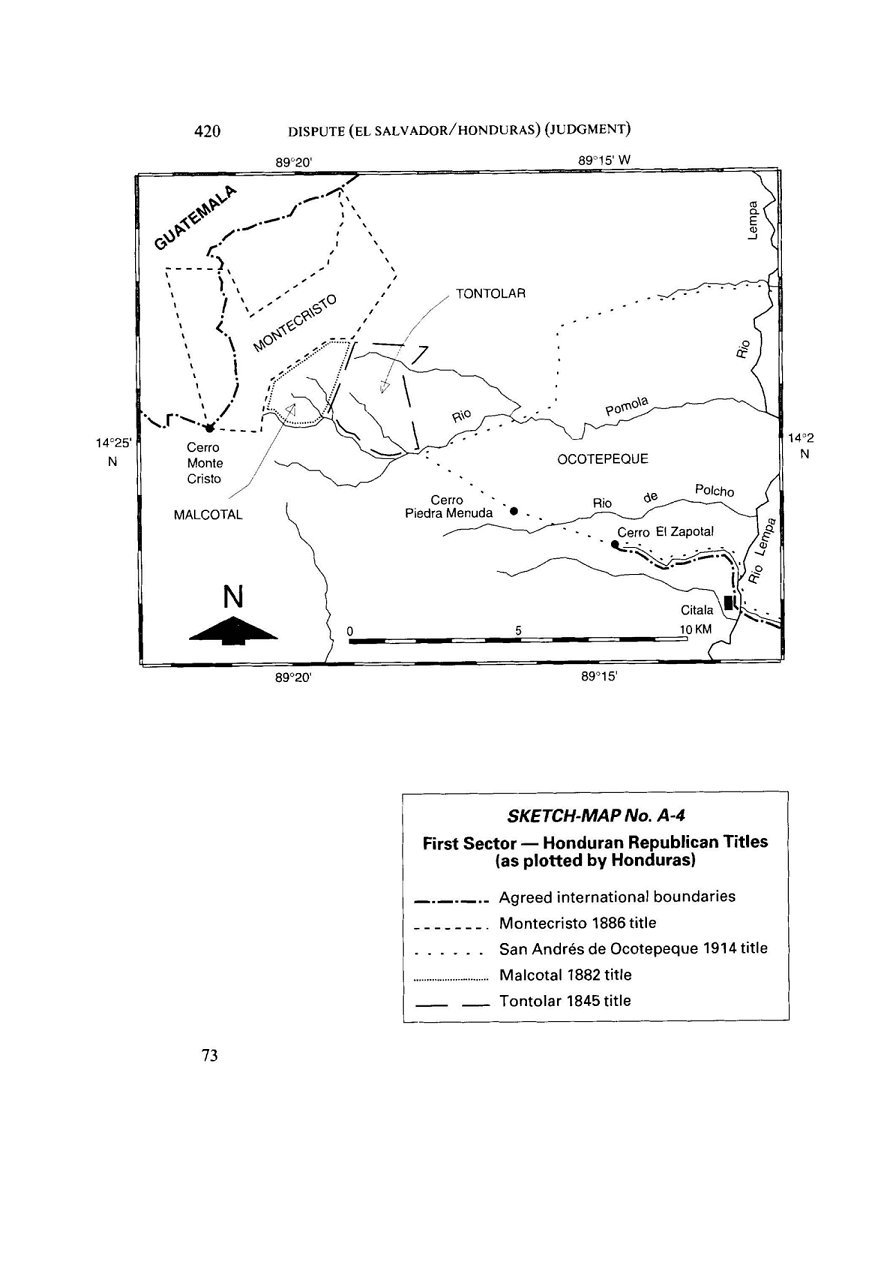
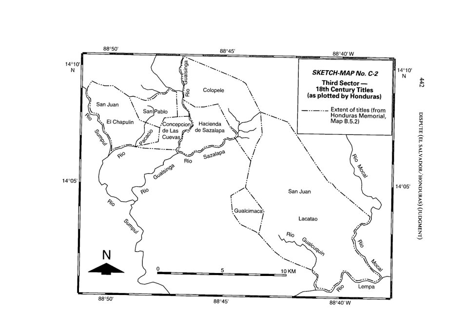
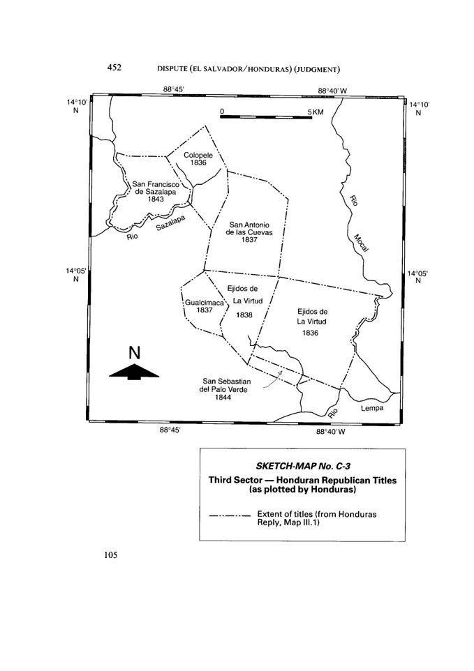
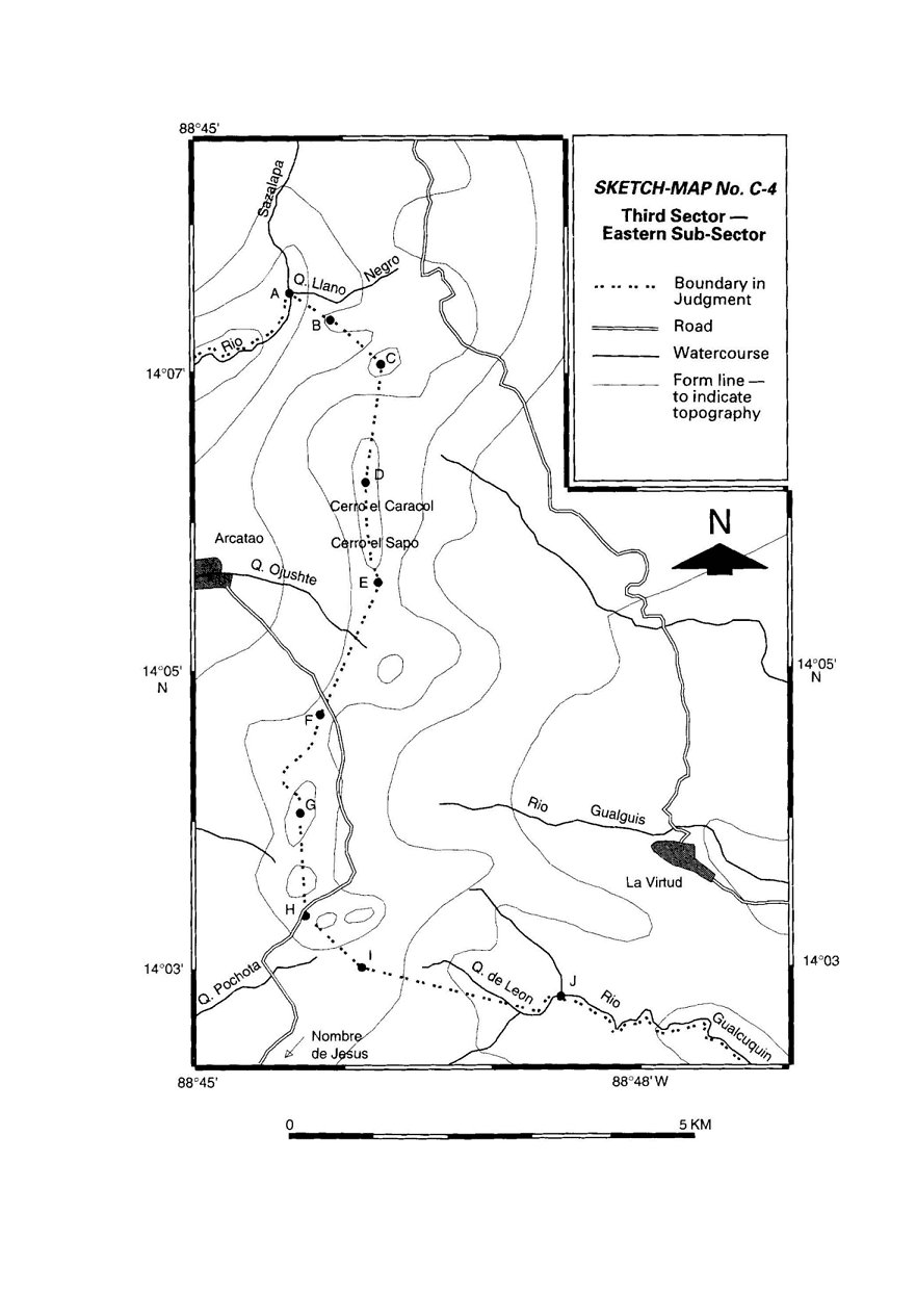
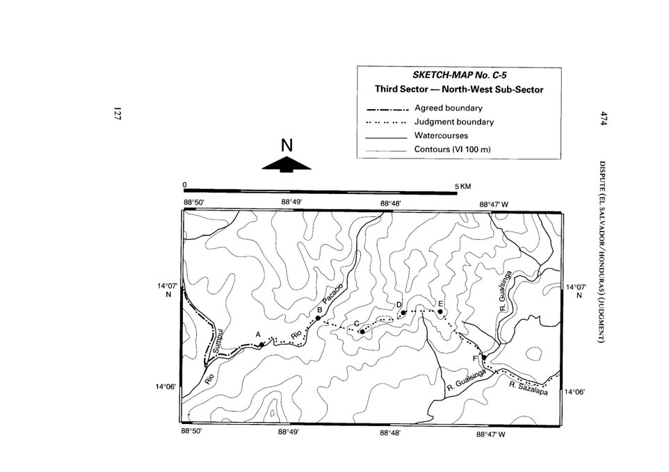
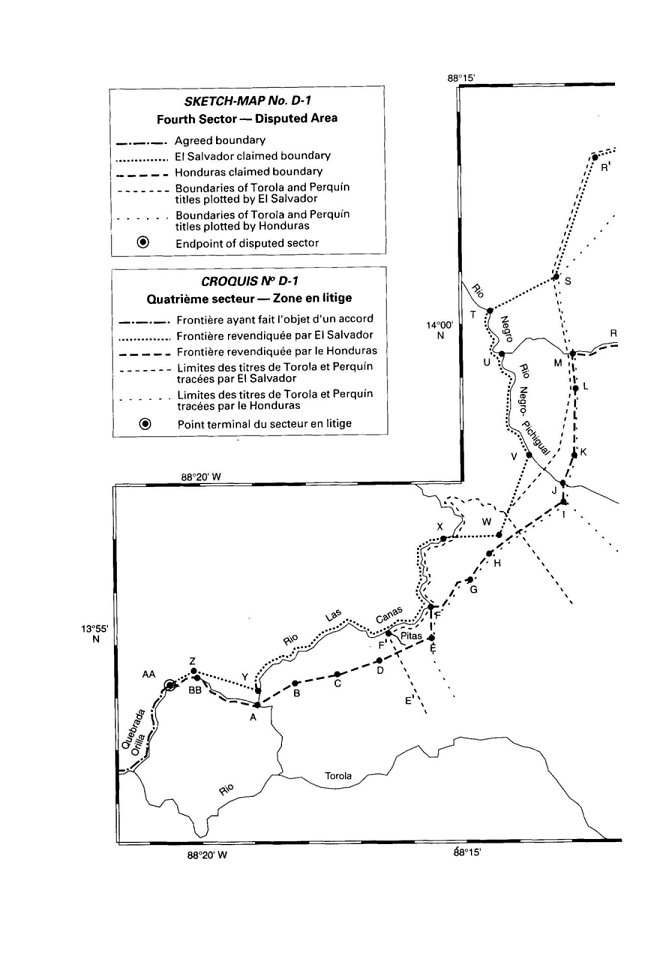
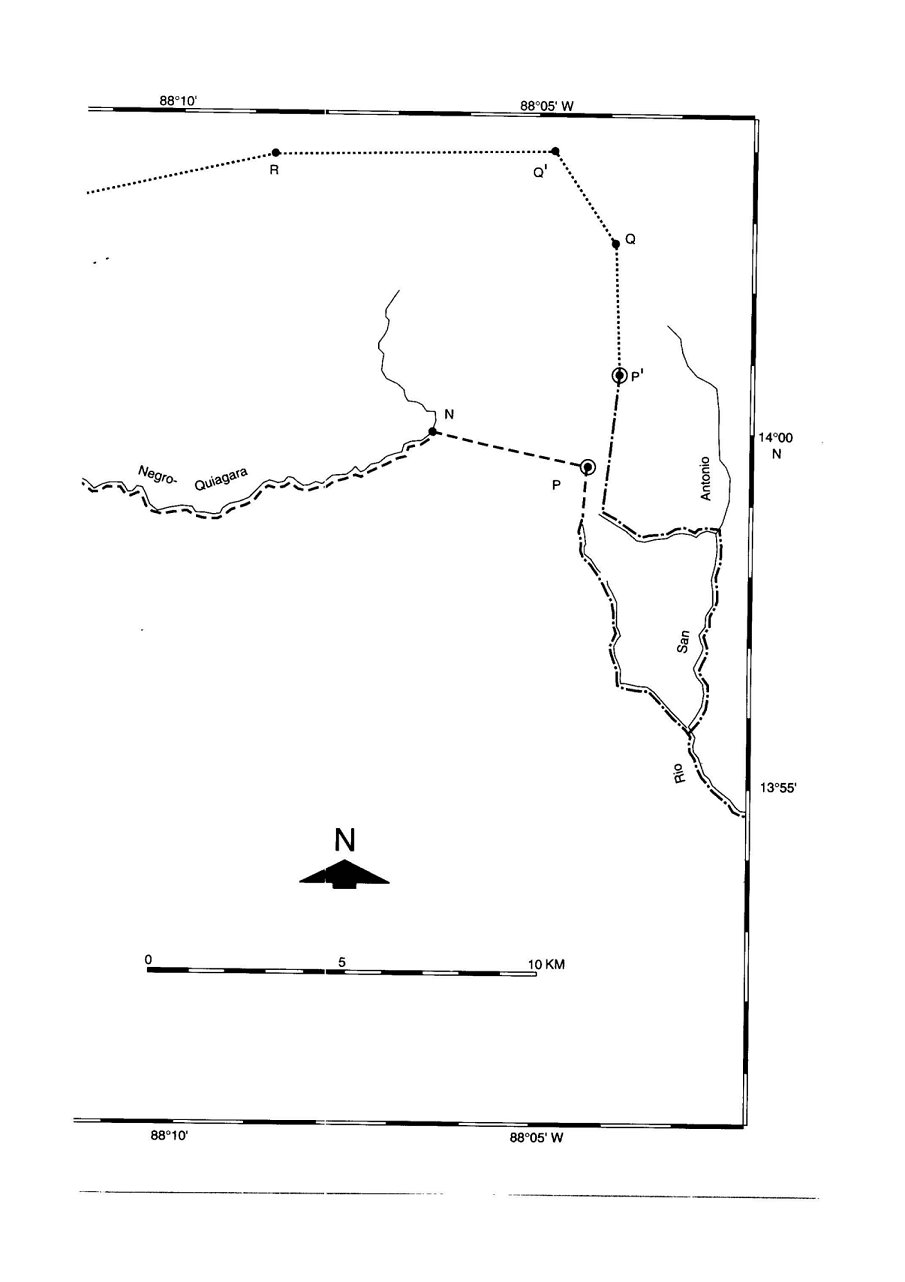
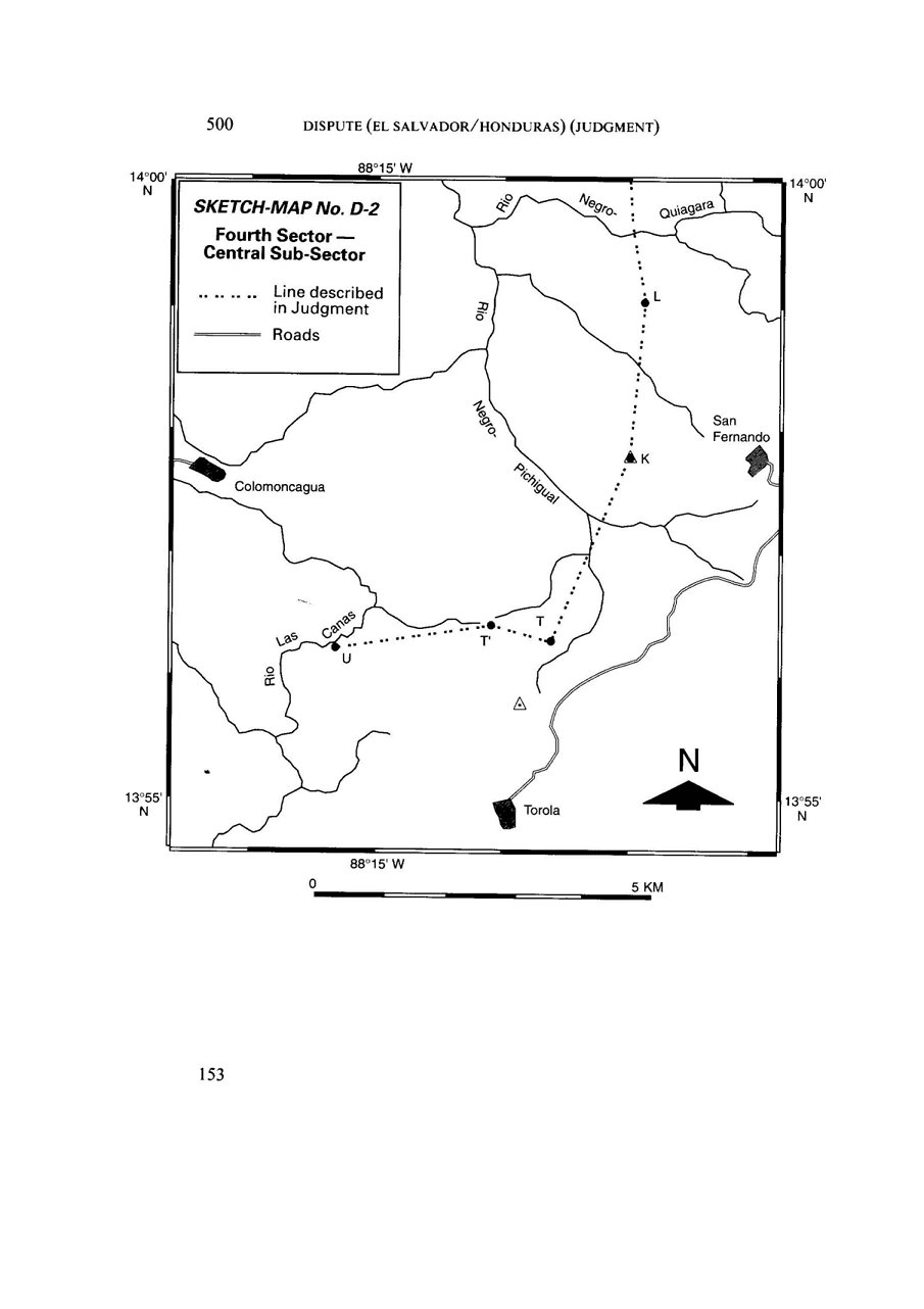
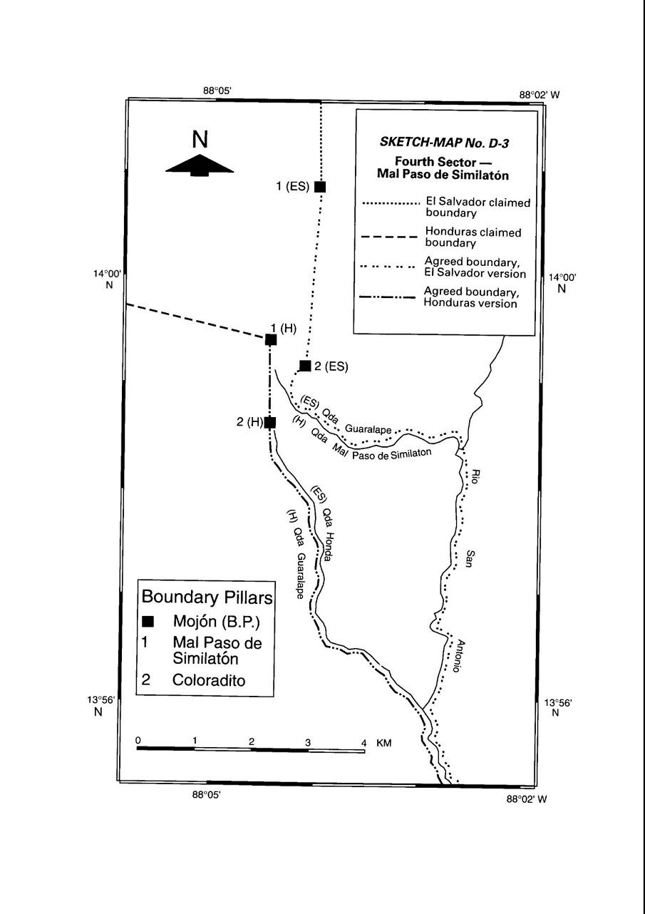
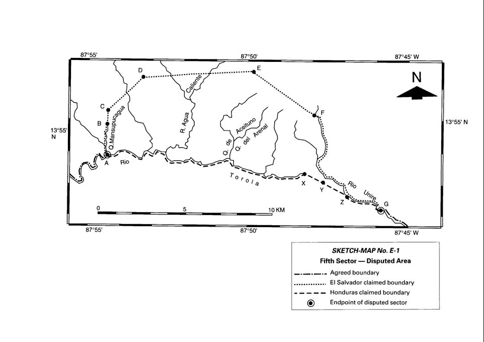
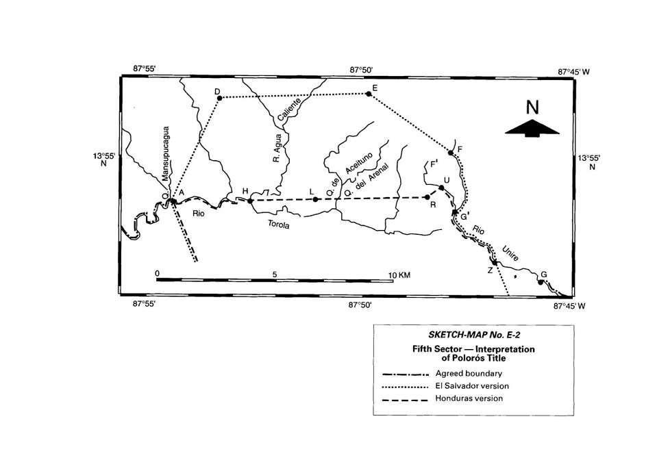
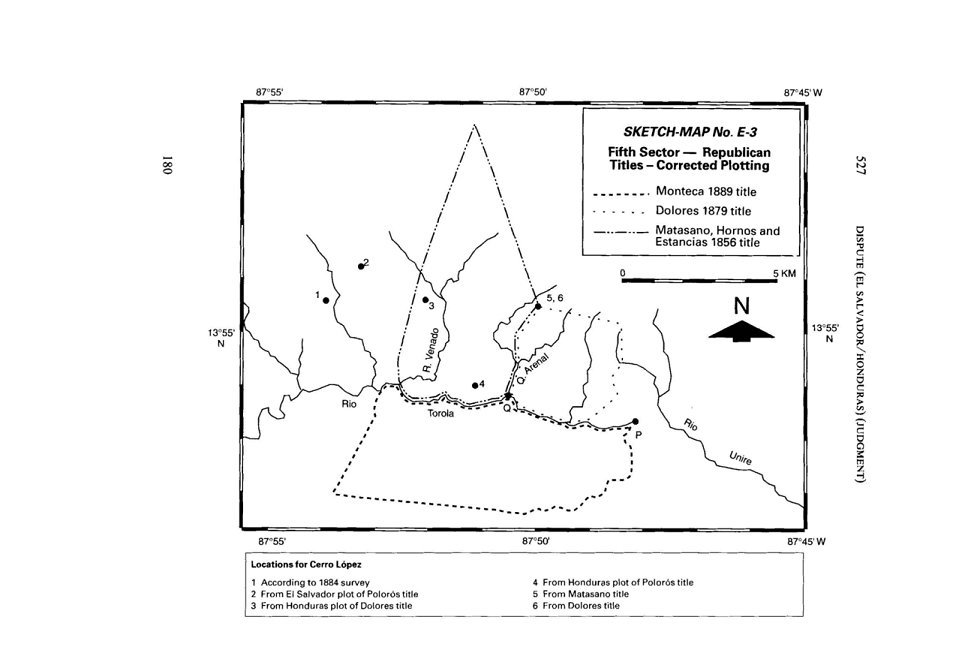
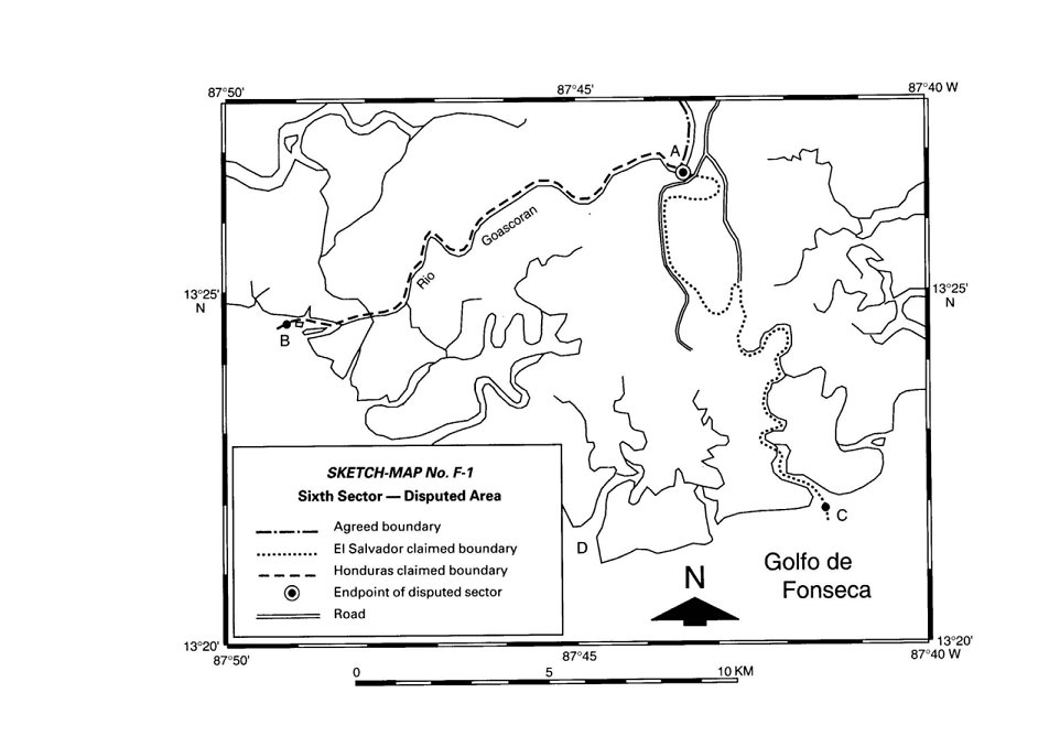
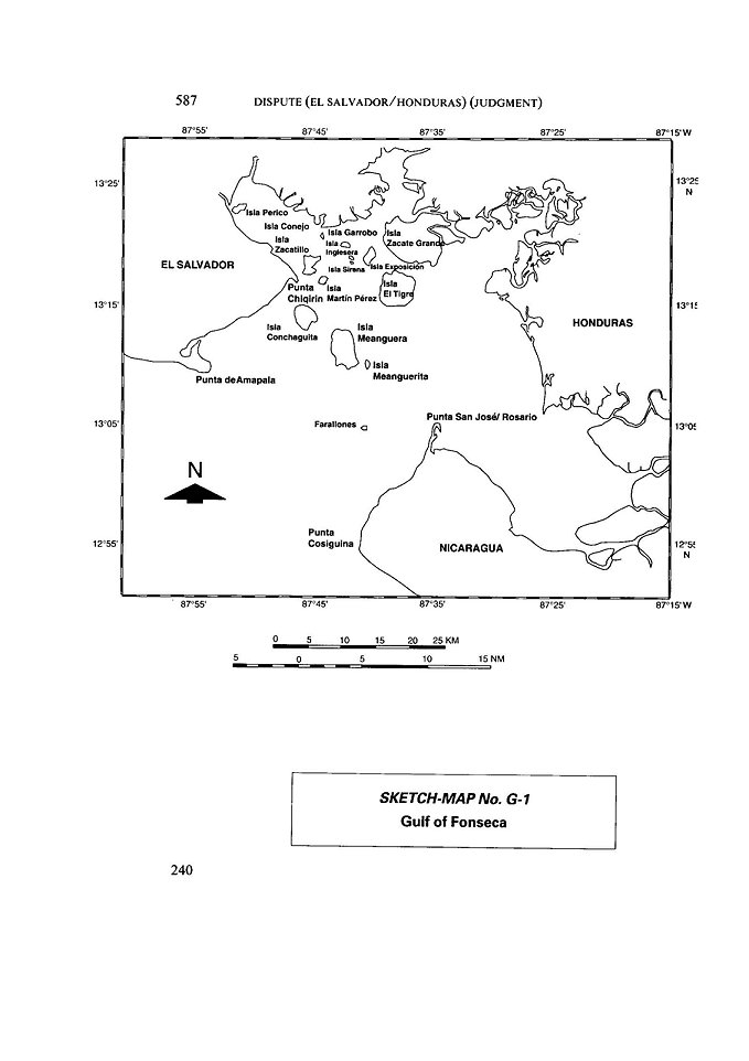