50,000+ decisions · 50+ institutions
|
|
International Case Law Database 50,000+ decisions · 50+ institutions |
|||
| Follow @worldcourts |
|
22 December 1986 |
|||||||||||||||||
|
General List No. 69 |
|||||||||||||||||
|
international Court of Justice |
|||||||||||||||||
|
Frontier Dispute |
|||||||||||||||||
|
Burkina Faso |
|||||||||||||||||
|
v. |
|||||||||||||||||
|
Mali |
|||||||||||||||||
|
judgment |
|||||||||||||||||
|
|||||||||||||||||
|
|
|||||||||||||||||
|
[p556]
THE CHAMBER OF THE INTERNATIONAL COURT OF JUSTICE formed to deal with the case above-mentioned, composed as above, after deliberation, delivers the following Judgment:
1. By a joint letter dated 14 October 1983, filed in the Registry of the Court on 20 October 1983, the Minister for Foreign Affairs and International Co-operation of the Republic of Mali and the Minister for Foreign Affairs of the Republic [p557] of Upper Volta transmitted to the Registrar a Special Agreement which was dated 16 September 1983 and had entered into force the same day, by which Upper Volta and Mali had agreed to submit to a chamber of the Court, to be constituted pursuant to Article 26, paragraph 2, of the Statute of the Court, a dispute relating to the delimitation of part of their common frontier.
2. The text of the Special Agreement of 16 September 1983 is as follows:
"The Government of the Republic of the Upper Volta and the Government of the Republic of Mali, Desiring to achieve as rapidly as possible a settlement of the frontier dispute between them, based in particular on respect for the principle of the intangibility of frontiers inherited from colonization, and to effect the definitive delimitation and demarcation of their common frontier, Referring to the Agreement concluded between them with a view to the settlement of the frontier dispute between them, Have agreed as follows: Article I Subject of the Dispute 1. The question put before the Chamber of the International Court of Justice formed in accordance with Article II below is as follows: What is the line of the frontier between the Republic of the Upper Volta and the Republic of Mali in the disputed area as defined below?' 2. The disputed area consists of a band of territory extending from the sector Koro (Mali) Djibo (Upper Volta) up to and including the region of the Beli. Article II Formation of a Chamber of the International Court of Justice The Parties submit the question put in Article I to a chamber of the International Court of Justice (hereinafter called 'the Chamber') formed pursuant to Article 26, paragraph 2, of the Statute of the International Court of Justice (hereinafter called 'the Court') and to the provisions of the present Special Agreement. Article III Procedure 1. The Parties agree that their pleadings and their oral argument shall be presented in the French language. 2. Without prejudice to any question as to the burden of proof, the Parties request the Chamber to authorize the following procedure for the pleadings :
(a) a Memorial filed by each Party not later than six months after the adoption by the Court of the Order constituting the Chamber; [p558] (b) a Counter-Memorial filed by each Party not later than six months after exchange of the Memorials; (c) any other pleading which the Chamber may find to be necessary. 3. The pleadings submitted to the Registrar shall not be transmitted to the other Party until the Registrar has received the corresponding pleading from the other Party. Article IV Judgment of the Chamber 1. The Parties accept the Judgment of the Chamber given pursuant to the Special Agreement as final and binding upon them. 2. Within one year after that Judgment the Parties shall effect the demarcation of the frontier. 3. The Parties request the Chamber to nominate, in its Judgment, three experts to assist them in the demarcation operation. Article V Entry into Force, Publication and Notification 1. The present Special Agreement shall come into force on the date of its signature. 2. It shall be registered with the Secretariat of the United Nations pursuant to Article 102 of the United Nations Charter by the more diligent Party. 3. In accordance with Article 40 of the Statute of the Court, the present Special Agreement shall be notified to the Registrar of the Court by a joint letter from the Parties. 4. If such notification is not effected in accordance with the preceding paragraph within one month from the entry into force of the present Special Agreement, it shall be notified to the Registrar of the Court by the more diligent Party."
3. Pursuant to Article 40, paragraph 3, of the Statute of the Court, and to Article 42 of the Rules of Court, copies of the notification and Special Agreement were transmitted to the Secretary-General of the United Nations, the Members of the United Nations and other States entitled to appear before the Court.
4. By a letter dated 29 August 1984, filed with the Registry on 4 September 1984, the Agent of Burkina Faso (formerly the Upper Volta) informed the Court of the change of name of his country, in force from 4 August 1984.
5. By the same letter, the Agent of Burkina Faso notified to the Court the choice by his Government of Mr. Francois Luchaire, Professor at the University of Paris I, to sit as judge ad hoc; and by a letter of 18 March 1985, the Co-Agent of Mali notified his Government's choice of Mr. Georges Abi-Saab, Professor at the Graduate Institute of International Studies, Geneva, to sit as judge ad hoc.
6. The Parties, duly consulted by the President on 14 March 1985 concerning the composition of the Chamber, expressed their wish for the formation of a Chamber of five Members, two of whom would be judges ad hoc chosen by them [p559] pursuant to Article 31 of the Statute of the Court, and confirmed their wish that the Court should proceed immediately to the constitution of the Chamber.
7. By an Order dated 3 April 1985 the Court, having noted the choice of a judge ad hoc by each of the Parties, decided to accede to the request of the Governments of Burkina Faso and the
Republic of Mali for the constitution of a special Chamber of five judges to deal with the case, and declared that Judges Lachs, Ruda and Bedjaoui had been elected to form, with the above-named judges ad hoc, such a Chamber, and that it was duly constituted with that composition.
8. By an Order made on 12 April 1985, pursuant to Article 92 of the Rules of Court, the President of the Court, referring to Article III, paragraph 2, of the Special Agreement, fixed 3 October 1985 as the time-limit for the filing of a Memorial by each Party. The Memorials in question were duly filed within the time-limit so fixed. By an Order dated 3 October 1985, the President of the Chamber, referring to Article III, paragraph 2, of the Special Agreement, fixed 2 April 1986 as the time-limit for the filing of a Counter-Memorial by each Party, reserving the subsequent procedure for further decision.
9. Before the expiry of the time-limit for the filing of the Counter-Memorials, the Parties submitted to the Chamber parallel requests for the indication of provisional measures. The Chamber held a public sitting on 9 January 1986 for the purpose of hearing the oral observations of the Parties and, on 10 January 1986, made an Order whereby it indicated certain provisional measures ; called upon the Agents of the Parties to notify the Registrar without delay of any agreement concluded between their Governments within the scope of point 1 D of the same Order ; and decided that, pending its final judgment, and without prejudice to the application of Article 76 of the Rules, the Chamber would remain seised of the questions covered by that Order.
10. In a letter dated 24 January 1986, and pursuant to point 2 of the above mentioned Order indicating provisional measures, the Co-Agent of the Republic of Mali transmitted to the Registrar the final communique, issued on 18 January 1986, of the first extraordinary conference of Heads of State and Government of the member countries of ANAD (Accord de non-agression et d'assistance en matiere de defense). That communique reported that the Heads of State of Burkina Faso and the Republic of Mali had agreed "to withdraw all their armed forces from either side of the disputed area and to effect their return to their respective respective territories".
11. On 2 April 1986, within the time-limit fixed for that purpose, the Parties filed their Counter-Memorials.
On the same day, they stated that they did not wish to present any further written pleadings. Since the Chamber did not consider that any further written pleadings were necessary, the case was ready for hearing.
12. Pursuant to Article 53, paragraph 2, of the Rules of Court, the Chamber, having ascertained the views of the Parties, decided that copies of the pleadings and documents annexed would be made accessible to the public with effect from the opening of the oral proceedings.
13. After the closure of the written proceedings both Parties produced further documents under Article 56 of the Rules. The Parties having been duly consulted pursuant to Articles 31 and 58, paragraph 2, of the Rules of Court, public sittings were held on 16-21 June and 24-26 June 1986, at which the Chamber was addressed by the following: [p560]
For Burkina Faso: H.E. Mr. Ernest Ouedraogo, Mr. Souleymane Diallo, H.E. Mr. Emmanuel Salembere, Mr. Alain Pellet, Mr. Jean-Pierre Cot, Mr. Jean Gateaud.
For the Republic of Mali: H.E. Lieutenant-Colonel Abdourahmane Maiga, Mr. Jean Salmon, Mr. Raymond Ranjeva, Mr. Pierre-Marie Dupuy, Mr. Diadie Traore, Mr. Paul Delmond.
14. At the hearing held on the morning of 26 June 1986 Burkina Faso, which had already completed its last round of oral argument, requested the Chamber to enable it to comment briefly upon the statement made the same day by a member of the Malian delegation. The Chamber decided to accede to that request and to authorize the Republic of Mali to comment in turn upon the observations to be made at that hearing by Burkina Faso, either orally, before the closure of the oral proceedings, or in writing within the ensuing 48 hours. The Republic of Mali conveyed to the Registry, within the prescribed time-limit, a written reply to the observations of the other Party, to which that reply was immediately communicated.
15. During the proceedings, the following Submissions were presented by the Parties:
On behalf of Burkina Faso, in the Memorial and Counter-Memorial and at the hearing of 24 June 1986 (afternoon):
"I. Burkina Faso respectfully requests the Chamber of the International Court of Justice, formed in accordance with the Special Agreement of 16 September 1983, to adjudge and declare that the course of the frontier between Burkina Faso and the Republic of Mali is constituted by the following line:
1. West of the point with the geographical co-ordinates: longitude 0 [degree] 40' 47" W latitude 15 [degree] 00'03" N
the line is as shown on the 1:200,000 scale map of the French Institut geographique national (1960 edition), the villages of Dioulouna, Oukoulou, Agoulourou and Koubo being located in Burkinabe territory.
2. East of the point with the geographical co-ordinates:
longitude 0 [degree] 40' 47" W latitude 15 [degree] 00' 03" N
the line corresponds to the information given in letter 191 CM2 of [p561] 19 February 1935, and on the 1:500,000 scale map, 1925 edition, as far as the northern point of the pool of In Abao.
3. From the northern point of the pool of In Abao, the line follows the course shown on the 1:500,000 scale map, 1925 edition, leaving the region of the Beli to Burkina Faso, as far as the tripoint with the frontier of Niger, which is formed by the heights of N'Gouma, situated to the north of the Kabia ford.
II. Burkina Faso respectfully requests the Chamber to appoint three experts to assist the Parties for the purpose of the demarcation operation, which is to be completed within one year of the delivery of the judgment."
On behalf of the Republic of
Mali,
in the Memorial and Counter-Memorial:
"The Government of the Republic of Mali submits as follows:
May it please the Chamber
To state that the frontier line between the Republic of Mali and Burkina Faso in the disputed area runs through the following points:
- Lofou, - the mosque-shaped enclosure situated 2 kilometres to the north of Diguel, - a point situated 3 kilometres to the south of Kounia, [p562] - the Selba baobab, - the Tondigaria, - Fourfare Tiaiga, - Fourfare Wande, - Gariol, - Gountoure Kiri, - a point to the east of the pool of Ketiouaire, having the following geographical co-ordinates:
longitude 0[degree]44'47"W latitude 14[degree] 56' 52" N
- the pool of Raf Naman, and from that point follows the marigot passing, in particular, through the pool of Fadar-Fadar, the pool of In Abao, the pool of Tin Akoff and the pool of In Tangoum, terminating at the Kabia ford";
at the hearing of 26 June 1986 (afternoon):
"The Government of the Republic of Mali submits as follows:
May it please the Chamber
1. To state that the frontier line between the Republic of Mali and Burkina Faso in the disputed area runs through the following points :
- Lofou, - the mosque-shaped enclosure situated 2 kilometres to the north of Diguel, - a point situated 3 kilometres to the south of Kounia, - the Selba baobab, - the Tondigaria, - Fourfare Tiaiga, - Fourfare Wande, - Gariol, - Gountoure Kiri, - a point to the east of the pool of Ketiouaire, having the following geographical co-ordinates:
longitude 0[degree] 44' 47" W latitude 14[degree] 56' 52" N
- the pool of Raf Naman,
and from that point follows the marigot passing, in particular, through the pool of Fadar-Fadar, the pool of In Abao, the pool of Tin Akoff and the pool of In Tangoum, terminating at the Kabia ford.
2. To refrain from determining the tripoint between the Republic of Mali, Burkina Faso and Niger.
3. To nominate, in its Judgment, three experts to assist the Parties in the demarcation operation (Art. IV, para. 3, of the Special Agreement of 16 September 1983)."
16. The task entrusted to the Chamber in this case by the Special Agreement concluded between the two Parties on 16 September 1983 is that of indicating the line of the frontier between Burkina Faso and the Republic of Mali (hereinafter called "Mali") in the disputed area, as defined in that Special Agreement. The two States have a common frontier of 1,380 kilometres according to Burkina Faso and 1,297 kilometres according to Mali, of which almost 900 kilometres according to Burkina Faso and almost 1,022 kilometres according to Mali have been successfully delimited by agreement between the Parties. The disputed area is defined by the Special Agreement as "a band of territory extending from the sector Koro (Mali) Djibo (Upper Volta) up to and including the region of the Beli". The Beli is the largest of the temporary watercourses in the region. It originates in the eastern slopes of the Hombori mountains and flows to the south-east before joining the Niger river outside the disputed area. In the dry season it consists of a chain of 11 pools. In their submissions to the Chamber, each of the Parties indicated the frontier line which it considered well-founded in law (these lines and the topography of the region are shown on sketch-map No.1 n1) ; according to either contention, the disputed frontier runs in an approximately west-east direction between Mali to the north and Burkina Faso to the south. The end-point of the frontier to the east, the position of which has not been determined, is also a point on the frontier between Niger and the two disputant States and is, accordingly, [p563] a tripoint. By the Niamey Protocol of 23 June 1964 between Upper Volta and Niger, those two States agreed that, for the purpose of delimiting their common frontier, they would have recourse to certain documents which were mentioned in the Protocol and treated as basic documents. However, the two States have not as yet carried out any delimitation operations. As for the frontier between Mali and Niger, it was decided at a recent meeting between representatives of those two States that bilateral negotiations would be set in train with a view to determining it, but no agreement has at present been concluded on the subject. In the present case, Mali maintains, for reasons to be considered below, that the Chamber must refrain from taking any decision on the position of the above mentioned tripoint. Burkina Faso, on the other hand, maintains that such a decision is necessary as an integral part of the task entrusted to the Chamber.
n1 A copy of this sketch-map will be found in a pocket at the end of this fascicle or inside the back cover of the volume of I.C.J. Reports 1986. [Note by the Registry.]
17. The Parties have argued at length over how the present dispute is to be classified in terms of a distinction sometimes made by legal writers between "frontier disputes" or "delimitation disputes", and "disputes as to attribution of territory". According to this distinction, the former refer to delimitation operations affecting what has been described as "a portion of land which is not geographically autonomous" whereas the object of the latter is the attribution of sovereignty over the whole of a geographical entity. Both Parties seem ultimately to have accepted that the present dispute belongs rather to the category of delimitation disputes, even though they fail to agree on the conclusions to be drawn from this. In fact, however, in the great majority of cases, including this one, the distinction outlined above is not so much a difference in kind but rather a difference of degree as to the way the operation in question is carried out. The effect of any delimitation, no matter how small the disputed area crossed by the line, is an apportionment of the areas of land lying on either side of the line. In the present case, it may be noted that the Special Agreement, in Article I, refers not merely to a line to be drawn, but to a disputed "area", which it defines as consisting of a "band" of territory encompassing the "region" of the Beli. Moreover, the effect of any judicial decision rendered either in a dispute as to attribution of territory or in a delimitation dispute, is necessarily to establish a frontier. It is not without interest that certain recent codifying conventions have used formulae such as a treaty which "establishes a boundary" or a "boundary established by a treaty" to cover both delimitation treaties and treaties ceding or attributing territory (cf. Vienna Convention on the Law of Treaties, Art. 62 ; Vienna Convention on Succession of States in respect of Treaties, Art, 11). In both cases, a clarification is made of a given legal situation with declaratory effect from the date of the legal title upheld by the court. This clarification is itself a new element; it was because the parties wished to see that element introduced [p564] that they went to court at all. If there had been no dispute or uncertainty, they would not have wished to do so. Hence it is not so much the nature and qualification of the present dispute as the Statute of the Court and the terms of the Special Agreement which must determine the nature and extent of the Chamber's task and functions in this case.
18. The Chamber also feels obliged to dispel a misunderstanding which might arise from this distinction between "delimitation disputes" and "disputes as to attribution of territory". One of the effects of this distinction is to contrast "legal titles" and "effectites". In this context, the term "legal title" appears to denote documentary evidence alone. It is hardly necessary to recall that this is not the only accepted meaning of the word "title". Indeed, the Parties have used this word in different senses. In fact, the concept of title may also, and more generally, comprehend both any evidence which may establish the existence of a right, and the actual source of that right. The Chamber will rule at the appropriate juncture on the relevance of the evidence produced by the Parties for the purpose of establishing their respective rights in this case. It will now turn to the question of the rules applicable to the case ; in so doing, it will, inter alia, ascertain the source of the rights claimed by the Parties.
19. The characteristic feature of the legal context of the frontier determination to be undertaken by the Chamber is that both States involved derive their existence from the process of decolonization which has been unfolding in Africa during the past 30 years. Their territories, and that of Niger, were formerly part of the French colonies which were grouped together under the name of French West Africa (AOF). Considering only the situation which prevailed immediately before the accession to independence of the two States, and disregarding previous administrative changes, it can be said that Burkina Faso corresponds to the colony of Upper Volta, and the Republic of Mali to the colony of Sudan (formerly French Sudan). It is to be supposed that the Parties drew inspiration from the principle expressly stated in the well-known resolution (AGH/Res. 16 (I)), adopted at the first session of the Conference of African Heads of State and Government, meeting in Cairo in 1964, whereby the Conference solemnly declared that all member States of the Organization of African Unity "solemnly . . . pledge themselves to respect the frontiers existing on their achievement of national independence", inasmuch as, in the preamble to their Special Agreement, they stated that the settlement of the dispute by the Chamber must be "based in particular on respect for the principle of the intangibility of frontiers inherited from colonization". It is clear from this text, and from the pleadings and oral arguments of the [p565] Parties, that they are in agreement as regards both the applicable law and the starting-point for the legal reasoning which is to lead to the determination of the frontier between their territories in the disputed area.
20. Since the two Parties have, as noted above, expressly requested the Chamber to resolve their dispute on the basis, in particular, of the "principle of the intangibility of frontiers inherited from colonization", the Chamber cannot disregard the principle of uti possidetis juris, the application of which gives rise to this respect for intangibility of frontiers. Although there is no need, for the purposes of the present case, to show that this is a firmly established principle of international law where decolonization is concerned, the Chamber nonetheless wishes to emphasize its general scope, in view of its exceptional importance for the African continent and for the two Parties. In this connection it should be noted that the principle of uti possidetis seems to have been first invoked and applied in Spanish America, inasmuch as this was the continent which first witnessed the phenomenon of decolonization involving the formation of a number of sovereign States on territory formerly belonging to a single metropolitan State. Nevertheless the principle is not a special rule which pertains solely to one specific system of international law. It is a general principle, which is logically connected with the phenomenon of the obtaining of independence, wherever it occurs. Its obvious purpose is to prevent the independence and stability of new States being endangered by fratricidal struggles provoked by the challenging of frontiers following the withdrawal of the administering power.
21. It was for this reason that, as soon as the phenomenon of decolonization characteristic of the situation in Spanish America in the 19th century subsequently appeared in Africa in the 20th century, the principle of uti possidetis, in the sense described above, fell to be applied. The fact that the new African States have respected the administrative boundaries and frontiers established by the colonial powers must be seen not as a mere practice contributing to the gradual emergence of a principle of customary international law, limited in its impact to the African continent as it had previously been to Spanish America, but as the application in Africa of a rule of general scope.
22. The elements of uti possidetis were latent in the many declarations made by African leaders in the dawn of independence. These declarations confirmed the maintenance of the territorial status quo at the time of independence, and stated the principle of respect both for the frontiers deriving from international agreements, and for those resulting from mere internal administrative divisions. The Charter of the Organization of African Unity did not ignore the principle of uti possidetis, but made only indirect reference to it in Article 3, according to which member States solemnly affirm the principle of respect for the sovereignty and territorial integrity of every State. However, at their first summit conference after the creation of the Organization of African Unity, the African Heads of State, in their Resolution mentioned above (AGH/Res. 16 (I)), adopted in Cairo [p566] in July 1964, deliberately defined and stressed the principle of uti possidetis juris contained only in an implicit sense in the Charter of their organization.
23. There are several different aspects to this principle, in its well known application in Spanish America. The first aspect, emphasized by the Latin genitive juris, is found in the pre-eminence accorded to legal title over effective possession as a basis of sovereignty. Its purpose, at the time of the achievement of independence by the former Spanish colonies of America, was to scotch any designs which non-American colonizing powers might have on regions which had been assigned by the former metropolitan State to one division or another, but which were still uninhabited or unexplored. However, there is more to the principle of uti possidetis than this particular aspect. The essence of the principle lies in its primary aim of securing respect for the territorial boundaries at the moment when independence is achieved. Such territorial boundaries might be no more than delimitations between different administrative divisions or colonies all subject to the same sovereign. In that case, the application of the principle of uti possidetis resulted in administrative boundaries being transformed into international frontiers in the full sense of the term. This is true both of the States which took shape in the regions of South America which were dependent on the Spanish Crown, and of the States Parties to the present case, which took shape within the vast territories of French West Africa. Uti possidetis, as a principle which upgraded former administrative delimitations, established during the colonial period, to international frontiers, is therefore a principle of a general kind which is logically connected with this form of decolonization wherever it occurs.
24. The territorial boundaries which have to be respected may also derive from international frontiers which previously divided a colony of one State from a colony of another, or indeed a colonial territory from the territory of an independent State, or one which was under protectorate, but had retained its international personality. There is no doubt that the obligation to respect pre-existing international frontiers in the event of a State succession derives from a general rule of international law, whether or not the rule is expressed in the formula uti possidetis. Hence the numerous solemn affirmations of the intangibility of the frontiers existing at the time of the independence of African States, whether made by senior African statesmen or by organs of the Organization of African Unity itself, are evidently declaratory rather than constitutive : they recognize and confirm an existing principle, and do not seek to consecrate a new principle or the extension to Africa of a rule previously applied only in another continent.
25. However, it may be wondered how the time-hallowed principle has been able to withstand the new approaches to international law as expressed in Africa, where the successive attainment of independence and [p567] the emergence of new States have been accompanied by a certain questioning of traditional international law. At first sight this principle conflicts outright with another one, the right of peoples to self-determination. In fact, however, the maintenance of the territorial status quo in Africa is often seen as the wisest course, to preserve what has been achieved by peoples who have struggled for their independence, and to avoid a disruption which would deprive the continent of the gains achieved by much sacrifice. The essential requirement of stability in order to survive, to develop and gradually to consolidate their independence in all fields, has induced African States judiciously to consent to the respecting of colonial frontiers, and to take account of it in the interpretation of the principle of self-determination of peoples.
26. Thus the principle of uti possidetis has kept its place among the most important legal principles, despite the apparent contradiction which explained its coexistence alongside the new norms. Indeed it was by deliberate choice that African States selected, among all the classic principles, that of uti possidetis. This remains an undeniable fact. In the light of the foregoing remarks, it is clear that the applicability of uti possidetis in the present case cannot be challenged merely because in 1960, the year when Mali and Burkina Faso achieved independence, the Organization of African Unity which was to proclaim this principle did not yet exist, and the above-mentioned resolution calling for respect for the pre-existing frontiers dates only from 1964.
27. In their pleadings and oral arguments, the two Parties have advanced conflicting views on the question whether equity can be invoked in the present case. They both agree that no use should be made of the Chamber's power, under Article 38 of the Statute, to decide the case ex aequo et bono if they had agreed to this. However, Mali urges that account should be taken of "that form of equity which is inseparable from the application of international law", which it sees as equivalent to equity infra legem. Although it did not object to this concept being resorted to, Burkina Faso considered that it was far from clear what the practical implications would be in this case. It emphasized that in the field of territorial boundary delimitation there is no equivalent to the concept of "equitable principles" so frequently referred to by the law applicable in the delimitation of maritime areas. Mali did not question this statement; it explained that what it had in mind was simply the equity which is a normal part of the due application of law.
28. It is clear that the Chamber cannot decide ex aequo et bono in this case. Since the Parties have not entrusted it with the task of carrying out an adjustment of their respective interests, it must also dismiss any possibility of resorting to equity contra legem. Nor will the Chamber apply equity praeter legem. On the other hand, it will have regard to equity infra legem, that is, that form of equity which constitutes a method of interpretation of [p568] the law in force, and is one of its attributes. As the Court has observed : "It is not a matter of finding simply an equitable solution, but an equitable solution derived from the applicable law," (Fisheries Jurisdiction, I.C.J. Reports 1974, p. 33, para. 78 ; p. 202, para. 69.) How in practice the Chamber will approach recourse to this kind of equity in the present case will emerge from its application throughout this Judgment of the principles and rules which it finds to be applicable.
29. The determination of a frontier line between two States is obviously a matter of international law, but the Parties both recognize also that the question has here to be appraised in the light of French colonial law, "droit d'outre-mer". Since the territories of the two States had been part of French West Africa, the former boundary between them became an international frontier only at the moment when they became independent. The line which the Chamber is required to determine as being that which existed in 1959-1960, was at that time merely the administrative boundary dividing two former French colonies, called terrhoires d'outre-mer from 1946 ; as such it had to be defined not according to international law, but according to the French legislation which was applicable to such territoires.
30. One clarification is, however, necessary as concerns the application of French droit d'outre-mer. By becoming independent, a new State acquires sovereignty with the territorial base and boundaries left to it by the colonial power. This is part of the ordinary operation of the machinery of State succession. International law - and consequently the principle of uti possidetis -- applies to the new State (as a State) not with retroactive effect, but immediately and from that moment onwards. It applies to the State as it is, i.e., to the "photograph" of the territorial situation then existing. The principle of uti possidetis freezes the territorial title ; it stops the clock, but does not put back the hands. Hence international law does not effect any renvoi to the law established by the colonizing State, nor indeed to any legal rule unilaterally established by any State whatever; French law -- especially legislation enacted by France for its colonies and territoires d'outre-mer -- may play a role not in itself (as if there were a sort of continuum juris, a legal relay between such law and international law), but only as one factual element among others, or as evidence indicative of what has been called the "colonial heritage", i.e., the "photograph of the territory" at the critical date.
31. With a view to a proper understanding of what follows, it should be [p569] recalled that from the beginning of the century up to the entry into force of the French Constitution of 27 October 1946, the territorial administration of French West Africa was centralized. It was headed by a governorgeneral, and was divided into colonies ; the power to create or abolish these belonged to the executive in Paris. At the head of each colony was a lieutenant-governor. The colonies were themselves made up of basic units called cercles which were administered by commandants de cercle; the creation and abolition of the cercles were the sole prerogative of the governor-general, who decided their overall extent. Each cercle in turn was composed of subdivisions, administered by chefs de subdivision. Finally, the subdivisions comprised cantons, which grouped together a number of villages. The creation and abolition of subdivisions and cantons within any particular cercle came within the jurisdiction of the lieutenant-governor of the colony of which the cercle formed part.
32. For the purpose of determining in broad terms what for each of the two Parties was the colonial heritage to which the uti possidetis was to apply, the origins of the French colonies concerned will be briefly retraced. For this purpose, however, it is unnecessary to go further back in the history of the colonies of French West Africa than 1919. At that time, the present territories of Mali and Burkina Faso both formed part of the colony of Upper Senegal and Niger. By virtue of a decree of the President of the French Republic dated 1 March 1919, the cercles of Gaoua, Bobo-Dioulasso, Dedougou, Ouagadougou. Dori and Fada N'Gourma, which had until then been part of Upper Senegal and Niger, were established as a separate colony with the name of Upper Volta. By a decree of 4 December 1920, the remaining territories, comprising what was left of Upper Senegal and Niger, were given the name of French Sudan, and by a decree of 13 October 1922 the Civil Territory of the Niger became an independent colony. The colony of French Sudan (or Sudan) continued to exist as such, or as a territoire d'outre-mer, until 1959 when it became the Sudanese Republic, and then achieved independence, as the Federation of Mali, on 20 June 1960. On the other hand, the decree of 1 March 1919 which had created Upper Volta was rescinded by a decree of 5 September 1932, and the cercles which had comprised Upper Volta were incorporated, in whole or in part, into Niger and into French Sudan or the Ivory Coast. The Chamber refers to paragraph 73 below and to sketch-map No. 2, which shows the distribution of the cercles in the disputed frontier region. Upper Volta was reconstituted in 1947 by the law 47-1707 of 4 September 1947, which rescinded outright the decree of 5 September 1932 that had abolished the colony of Upper Volta, and stated that the boundaries of "the re-established territory of Upper Volta" were to be "those of the former colony of Upper Volta on 5 September 1932". It was this reconstituted Upper Volta which subsequently obtained independence on 5 August 1960, and took the name of Burkina Faso in 1984. [p570]
33. For both Parties, the problem is to ascertain what is the frontier which was inherited from the French administration, that is, the frontier which existed at the moment of independence. However, their views diverge somewhat as to the exact date to be chosen for that purpose. In the opinion of Burkina Faso, the date to be taken into consideration is that of the accession of each Party to independence : 20 June 1960 for Mali and 5 August I960 for Burkina Faso. In Mali's opinion, it is necessary to go back to the "last date on which the French colonial authorities participated in the exercise of jurisdiction for administrative organization", a date which, for the reasons explained in its Memorial, Mali fixes at 30 January 1959 for the Sudanese Republic and 28 February 1959 for Upper Volta. The Parties have however, while holding to their respective contentions as to the legal grounds which warrant the choice of these dates, ultimately admitted that the point has no practical implications for the case. They are requesting the Chamber to ascertain what, in the disputed area, was the frontier between the territoires d'outre-mer of Sudan and of Upper Volta as it existed in 1959-1960. Although it was said on a number of occasions, during the colonial period, that there was no frontier which was fully determined by direct or delegated legislation, the two Parties both agree that when they became independent there was a definite frontier. Both of them also accept that no modification of the frontier took place between January 1959 and August 1960, or has taken place since.
34. The Parties have expounded at length the origins of the frontier dispute which is presently before the Chamber. Since however the line of the frontier has to be defined as it existed in the years 1959-1960, and the Parties agree that no legal validity attaches to any subsequent acts of administration which may have been performed by either of them on the territory of the other, a review of the frontier incidents and the efforts made to bring the dispute to an end would hardly be pertinent. Nevertheless, one Burkinabe argument warrants particular attention. This argument is based on the conduct of the Marian Government during the negotiations which led to agreements being concluded for the delimitation of the 900 or 1,022 kilometres of frontier which are no longer in dispute, and on that Government's attitude towards the work of a Mediation Commission of the Organization of African Unity which sat in 1975. According to Burkina Faso, Mali accepted as binding the solution to the dispute outlined by that Commission. Since this argument from acquiescence would, if correct, make it unnecessary to endeavour to establish the frontier inherited from the colonial period, it should be dealt with at the outset as a preliminary question.
35. Very soon after achieving independence, the Parties set up bilateral [p571] negotiating machinery with a view to resolving their frontier problems. Thus, as early as 29 November 1961, they gave institutional shape to the regular meetings already held during the colonial period between the heads of the frontier districts, by establishing a "mixed commission composed of the chefs de circonscription". Subsequently, on 25 February 1964, they instituted a "joint commission" comprising for each State a government delegate, a geographer, a topographer and the commandants of the frontier cercles, its task being to make proposals by 15 June 1964 "for the delimitation of the frontier on the basis of the preparatory work of the chefs de circonscription". This commission was replaced by a "standing joint commission" created on 8 May 1968, which comprised the Ministers of the Interior together with representatives of various ministries of both countries. The task entrusted to this latter body was a much broader one: general co-operation between the two countries. Finally, in the same year, a conference of Ministers of the Interior of both Parties created a "mixed technical commission", comprising for each State a government representative, a topographer, a geographer and the chefs de circonscription concerned. The task of this commission was "to survey and identify the frontier in accordance with the pre-independence documents held by the Governments of Mali and Upper Volta". The Parties have produced a number of records and documents emanating from these bodies.
36. Following an armed conflict between the two countries which broke out on 14 December 1974, appeals were made for conciliation, notably by the head of State of Somalia, then President of the Organization of African Unity, and by the President of Senegal. On 26 December 1974, the Presidents of Upper Volta, Mali and Togo met at Lome and decided to set up a Mediation Commission composed of Togo, Niger, Guinea and Senegal. One of the tasks of the Commission as stated in the Lome communique was that of "seeking a solution to the frontier dispute on the basis of existing legal documents". The Mediation Commission met on 6 and 7 January 1975 and set up a Military Sub-Commission and a Legal Sub-Commission ; the latter's role included "drawing up an initial draft proposal for submission to the Commission, comprising . . . an outline solution . . . ". On 11 April 1975, the head of State of Mali granted an interview to the France-Presse agency, during which he stated that:
"Mali extends over 1,240,000 square kilometres, and we cannot justify fighting for a scrap of territory 150 kilometres long. Even if the Organization of African Unity Commission decides objectively that the frontier line passes through Bamako, my Government will comply with the decision."
37, The Legal Sub-Commission presented its report to the Mediation Commission on 14 June 1975, suggesting "that the Parties should accept the following . . . ". Paragraph A refers to the implementation of the principle [p572] of the intangibility of colonial frontiers, and to the use for that purpose of texts and maps. In paragraph B, the Sub-Commission presents specific proposals for the frontier line. On 17 and 18 June 1975, the Mediation Commission met at Lome. With the participation of the Presidents of Upper Volta and Mali, the Commission adopted a final communique stating that:
"Upper Volta and Mali undertake to bring their dispute to an end on the basis of the recommendations of the Mediation Commission.
The two Parties agree to the establishment by the Chairman of the Mediation Commission of a neutral technical committee . . . the task of this committee being to determine the location of the villages of Dionouga, Diolouna, Oukoulou and Koubo, to reconnoitre the frontier and to make proposals for its materialization to the Commission."
On 10 July 1975, the heads of State of both Parties met again at Conakry, at the invitation of the President of the Republic of Guinea. In a joint declaration published on this occasion, the Parties
"welcome the efforts made and the results achieved by the Mediation Commission of the Organization of African Unity, and affirm their common intention to do their utmost to transcend [pdepasser] these results, especially by facilitating the delimitation of the frontier between the two States in order to place the final seal on their reconciliation".
The neutral technical committee which had been spoken of at the meeting of 17 and 18 June 1975 was in fact set up by the chairman of the Mediation Commission, but was unable to fulfil its function. To enable the committee to accomplish it, the proposal had been made that a systematic survey should be made of the frontier zone on the basis of aerial photographs, a task to be performed by the French Institut geographique national. Mali refused to grant the necessary authorizations for overflights of its territory, and despite further contacts between the Parties, this was how matters remained until the conclusion of the Special Agreement by which the case was brought before the Court.
38. The two Parties agree, in the first place, that the Mediation Commission of the Organization of African Unity was not a jurisdictional body, and lacked the power to take legally binding decisions ; in the second place, that the Commission never actually completed its work, since it took no steps formally to take note of the reports of its subcommissions, and submitted no definitive overall solution for consideration by the Parties in the context of its mediating functions. However, Burkina Faso argues that there was acquiescence by Mali in the solutions outlined in this context, on two distinct grounds. On the basis of the facts described above it argues, firstly, that the final communique of the Lome summit conference of [p573] 27 December 1974, setting up the Mediation Commission, has to be treated as a genuine international agreement binding upon the States parties. Further, while admitting that the Mediation Commission was not empowered to render binding decisions, Burkina Faso alleges that the report of the Legal Sub-Commission, endorsed by the summit meeting of Heads of State or Government held at Lome on 17 and 18 June 1975, became binding for Mali because Mali had proclaimed itself already bound by the report which might have been made by the Mediation Commission, by virtue of the declaration made by the President of Mali on 11 April 1975. The effect of the Lome final communique of 18 June 1975, which according to Burkina Faso emanated from the enlarged Mediation Commission and is also an international agreement which the Parties are bound to observe, was to reinforce Mali's obligations in the matter. Mali challenges this interpretation of the statement of its President of 11 April 1975; it observes, in the first place, that the Commission would have to have had a power of decision, which was not legally the case, and in the second place, that the comment by Mali's head of State was merely "a witticism of the kind regularly uttered at press conferences", which implied "no more than that Mali is anxious to consider the Commission's recommendations with goodwill and in good faith". Mali also challenges Burkina Faso's interpretation of the final communique of 18 June 1975. In Mali's view, the Mediation Commission did not, strictly speaking, make any recommendation, and the heads of State did not accept any predetermined line ; on the contrary, in entrusting a neutral technical committee with the task of determining the position of certain villages, reconnoitring the frontier, and making proposals to the Commission for its materialization, they instructed that committee to produce new proposals, and this, in Mali's opinion, surely indicates that the proposals of the subcommissions were not final ones.
39. The statement of Mali's Head of State on 11 April 1975 was not made during negotiations or talks between the two Parties ; at most, it took the form of a unilateral act by the Government of Mali. Such declarations "concerning legal or factual situations" may indeed "have the effect of creating legal obligations" for the State on whose behalf they are made, as the Court observed in the Nuclear Tests cases (I.C.J. Reports 1974, pp. 267, 472). But the Court also made clear in those cases that it is only "when it is the intention of the State making the declaration that it should become bound according to its terms" that "that intention confers on the declaration the character of a legal undertaking" (ibid.). Thus it all depends on the intention of the State in question, and the Court emphasized that it is for the Court to "form its own view of the meaning and scope intended by the author of a unilateral declaration which may create a legal obligation" (ibid, pp. 269, 474). In the case concerning Military and Paramilitary Activities in and against Nicaragua (Nicaragua v. United States of America), the Court examined a communication transmitted by the Junta of National Reconstruction of Nicaragua to the Organization of American [p574] States, in which the Junta listed its objectives; but the Court was unable to find anything in that communication "from which it can be inferred that any legal undertaking was intended to exist" (I.C.J. Reports 1986, p. 132, para. 261). The Chamber considers that it has a duty to show even greater caution when it is a question of a unilateral declaration not directed to any particular recipient.
40. In order to assess the intentions of the author of a unilateral act, account must be taken of all the factual circumstances in which the act occurred. For example, in the Nuclear Tests cases, the Court took the view that since the applicant States were not the only ones concerned at the possible continuance of atmospheric testing by the French Government, that Government's unilateral declarations had "conveyed to the world at large, including the Applicant, its intention effectively to terminate these tests" (I.C.J. Reports 1974, p. 269, para. 51 ; p. 474, para. 53). In the particular circumstances of those cases, the French Government could not express an intention to be bound otherwise than by unilateral declarations. It is difficult to see how it could have accepted the terms of a negotiated solution with each of the applicants without thereby jeopardizing its contention that its conduct was lawful. The circumstances of the present case are radically different. Here, there was nothing to hinder the Parties from manifesting an intention to accept the binding character of the conclusions of the Organization of African Unity Mediation Commission by the normal method : a formal agreement on the basis of reciprocity. Since no agreement of this kind was concluded between the Parties, the Chamber finds that there are no grounds to interpret the declaration made by Mali's head of State on 11 April 1975 as a unilateral act with legal implications in regard to the present case.
41. The second argument advanced by Burkina Faso to establish acquiescence by Mali concerns the principles of delimitation approved by the Legal Sub-Commission of the Organization of African Unity Mediation Commission. In its report, the Sub-Commission did not refer solely to the principle of the intangibility of colonial frontiers ; it also defined, for the purpose of applying it, the appropriate method of appraising the respective weight of the evidence produced -- specifically, the texts on the one hand and the maps on the other --, and of contrasting or reconciling these where necessary. Burkina Faso considers that the principles adopted by the Sub-Commission in this matter were the same as those which it contends should be applied to the delimitation of the whole of its frontier with Mali. It also claims that Mali agreed to these principles being taken into consideration for the purpose of delimiting the greater part of the common frontier. It concludes therefore that Mali may not reject their application to the determination of the frontier in the disputed area, in view of the principle that a State cannot disclaim in a particular instance rules and principles to which it has acquiesced in comparable circumstances, [p575] when their operation becomes disadvantageous to itself. This latter principle, according to Burkina Faso, must be combined with that of the unity of the frontier line. It thus argues that the delimitation of the frontier in the disputed area has to be approached as a whole; it takes the view that unless there are compelling reasons to the contrary, the principles of delimitation and the evidence already recognized by the Parties as relevant for the purpose of drawing their common frontier over approximately 1,000 kilometres, do not cease to be relevant in delimiting the remaining 300 kilometres. Mali however states that it could not accept the report of the Legal Sub-Commission, on its merits, as an instrument potentially offering a reasonable solution, even on a compromise basis, and claims that it never did accept it. Referring to the principles imputed by Burkina Faso to the Sub-Commission, Mali rejects the position of the other Party particularly on the questions of the importance of the maps' and conduct evincing effectivity.
42. It must be recalled in this connection that the Chamber, whose judgment "shall be considered as rendered by the Court" (Statute, Art. 27), is bound to settle the present dispute "in accordance with international law" (Art. 38). Accordingly, it is on the basis of international law that the Chamber will have to fix the frontier line, weighing for that purpose the legal force of the respective evidence submitted by the Parties for its appraisal. It is therefore of little significance whether Mali adopted a particular approach, either in the course of negotiations on frontier questions, or with respect to the conclusions of the Legal Sub-Commission of the Organization of African Unity Mediation Commission, and whether that approach may or may not be construed to reflect a specific position, or indeed to signify acquiescence, towards the principles and rules, including those which determine the respective weight of the various kinds of evidence applicable to the dispute. If these principles and rules are applicable as elements of law in the present case, they remain so whatever Mali's attitude. If the reverse is true, the Chamber could only take account of them if the two Parties had requested it to do so, or had given such principles and rules a special place in the Special Agreement, as "rules expressly recognized by the contesting States" (Art. 38, para. 1 (a), of the Statute).
"While the Court is . . . bound to have regard to all the legal sources specified in Article 38, paragraph 1, of the Statute . . . it is also bound, in accordance with paragraph 1 (a), of that Article, to apply the provisions of the Special Agreement." (I.C.J. Reports 1982, p. 37, para. 23.)
43. The reason why the argument from the notion of acquiescence, as set out above, has been dealt with by the Chamber at an initial stage of its Judgment is that it is in the nature of a preliminary question. If the [p576] Chamber had upheld the contention that the report of the Legal Sub-Commission of the Mediation Commission had become binding, it would only have had to endorse it. Both the Parties have however resorted in other connections to arguments bearing upon acquiescence, estoppel or the conduct of the Parties. Mali has referred to "the inconsistency shown by Upper Volta and thereafter by Burkina Faso" towards a regulation (Order 2728 AP of 27 November 1935) on which, as will be seen later, Mali rests its claims in regard to the western part of the disputed area. For its part, Burkina Faso argues in connection with a projected definition of the boundary between the colonies of French Sudan and Niger in 1935, said to have been accepted by the Governor of Sudan as a description of the existing boundary, that "what was accepted by French Sudan is therefore binding upon Mali by virtue of State succession". However, the Chamber considers that these questions should be reserved and examined, if necessary, when the Chamber turns to its examination of the texts in question.
44. Before turning to the various kinds of evidence invoked by the Parties to support their claims in regard to the line of the frontier, the Chamber must dispose of a further preliminary question, namely : what are its powers in the matter of fixing the tripoint which forms the end-point of the frontier between the Parties. In its Memorial, Mali observes that the tripoint Niger/Mali/Burkina Faso cannot be determined by the two Parties without Niger's agreement, nor can it be determined by the Chamber, which may not affect the rights of a third State not a party to the proceedings. According to Mali, the eastern extremity of the frontier in the disputed area must be determined in such a way as not to infringe these rights, and this could only be done if the delimitation were to terminate at a given point which is not the end-point. Burkina Faso, on the other hand, considers that the Chamber must perform the whole of the task entrusted to it by the Special Agreement, and must for that purpose decide the position of the tripoint. In its view, if the Chamber discharges its task in this manner, it would not infringe the rights of Niger, since the sole object of its decision would be to determine the line of the frontier between the Parties. Burkina Faso believes that although the meeting-point between that frontier and the frontier of Niger is a tripoint, the determination of that point will be a consequence and not the object of the Chamber's judgment. Mali rejects the argument that the Special Agreement requires the Chamber to determine the tripoint, pointing out that the text refers to a "disputed area" consisting of "a band of territory extending from the sector Koro (Mali) Djibo (Upper Volta) up to and including the region of the Beli". According to Mali, the text is silent as to the actual point where the Chamber's line is to begin or end; and the Chamber cannot determine the tripoint without simultaneously deciding the question of Niger's rights in its relation to each of the Parties. Burkina Faso replies by, inter alia, [p577] drawing the Chamber's attention to the preamble to the Special Agreement, according to which the Parties are seeking "the definitive delimitation and demarcation of their common frontier". While holding to its formal submission, which mentions the "tripoint", Burkina Faso nevertheless concedes that it might be preferable for the judgment to refer to "the eastern extremity of the common frontier" between the Parties, rather than to the tripoint.
45. In the Chamber's opinion, it should first be recalled that there is a distinction between the question of the jurisdiction conferred upon it by the Special Agreement concluded between the Parties, and the question whether "the adjudication sought by the Applicant is one which the Court's judicial function permits it to give", a question considered by the Court in the case concerning the Northern Cameroons, among others (I.C.J. Reports 1963, p. 31). As it also stated in that case, "even if the Court, when seised, finds that it has jurisdiction, the Court is not compelled in every case to exercise that jurisdiction" (ibid, p. 29). But in the absence of "considerations which would lead it to decline to give judgment" (I.C.J. Reports 1974, p. 271, para. 58), the Court is bound to fulfil the functions assigned to it by its Statute. Moreover, the Court has recently confirmed the principle that it "must not exceed the jurisdiction conferred upon it by the Parties, but it must also exercise that jurisdiction to its full extent" (Continental Shelf (Libyan Arab Jamahiriya/Malta), I.C.J. Reports 1985, p. 23). In the present case, the Chamber finds it to be clear from the wording of the Special Agreement -- including its preamble -- that the common intention of the Parties was that the Chamber should indicate the frontier line between their respective territories throughout the whole of the "disputed area", and that this area was for them the whole of the frontier not yet delimited by joint agreement.
46. The Chamber also considers that its jurisdiction is not restricted simply because the end-point of the frontier lies on the frontier of a third State not a party to the proceedings. The rights of the neighbouring State, Niger, are in any event safeguarded by the operation of Article 59 of the Statute of the Court, which provides that "The decision of the Court has no binding force except between the parties and in respect of that particular case". The Parties could at any time have concluded an agreement for the delimitation of their frontier, according to whatever perception they might have had of it, and an agreement of this kind, although legally binding upon them by virtue of the principle pacta sunt servanda, would not be opposable to Niger. A judicial decision, which "is simply an alternative to the direct and friendly settlement" of the dispute between the Parties (P.C.I.J., Series A, No. 22, p. 13), merely substitutes for the solution stemming directly from their shared intention, the solution arrived at by a court under the mandate which they have given it. In both instances, the solution only has legal and binding effect as between the States which have accepted it, either directly or as a consequence of having accepted the [p578] court's jurisdiction to decide the case. Accordingly, on the supposition that the Chamber's judgment specifies a point which it finds to be the easternmost point of the frontier, there would be nothing to prevent Niger from claiming rights, vis-a-vis either of the Parties, to territories lying west of the point identified by the Chamber.
47. Admittedly, in the case of the Continental Shelf (Libyan Arab Jama-hiriya/Malta), the Court confined its decision to a certain geographical area because, as it explained,
"the Court has not been endowed with jurisdiction to determine what principles and rules govern delimitations with third States, or whether the claims of the Parties outside that area prevail over the claims of those third States in the region" (I.C.J. Reports 1985, p. 26, para. 21).
But the process by which a court determines the line of a land boundary between two States can be clearly distinguished from the process by which it identifies the principles and rules applicable to the delimitation of the continental shelf. The legal considerations which have to be taken into account in determining the location of the land boundary between parties are in no way dependent on the position of the boundary between the territory of either of those parties and the territory of a third State, even where, as in the present case, the rights in question for all three States derive from one and the same predecessor State. On the other hand, in continental shelf delimitations, an agreement between the parties which is perfectly valid and binding on the treaty level may, when the relations between the parties and a third State are taken into consideration, prove to be contrary to the rules of international law governing the continental shelf (see North Sea Continental Shelf, I.C.J. Reports 1969, p. 20, para. 14; pp. 27-28, paras. 35-36). It follows that a court dealing with a request for the delimitation of a continental shelf must decline, even if so authorized by the disputant parties, to rule upon rights relating to areas in which third States have such claims as may contradict the legal considerations -- especially in regard to equitable principles -- which would have formed the basis of its decision.
48. At most, the Chamber should consider whether, in this case, considerations related to the need to safeguard the interests of the third State concerned require it to refrain from exercising its jurisdiction to determine the whole course of the line. In this regard, the Chamber is not unmindful of the fact that Niger and Burkina Faso agreed by the Niamey Protocol of 23 June 1964, to "treat as basic documents for the determination of the frontier" between them a general Order issued by the Governor-General of French West Africa on 31 August 1927, an erratum to that Order dated 5 October 1927 and a 1:200,000 scale map of the Institut geographique national from the year 1960, these being the same documents as those invoked by Burkina Faso in support of its contention regarding the location of the end-point of the frontier with Mali. Pointing to this fact, Burkina Faso infers that if this point were fixed according to the information [p579] contained in these documents, there would be no infringement of Niger's rights. The Chamber cannot share this view. From the mere fact that the same documents are used as the starting-point for the Chamber's reasoning and for the negotiations between Burkina Faso and Niger, it cannot be inferred that the practical conclusions reached in both operations, regarding the location of the end-point of the frontier between Burkina Faso and Mali, would necessarily be the same. It is clear that the interpretation given by the Chamber, for the purposes of this case, of the 1927 Order and its erratum will not be opposable to Niger, which has not participated in the proceedings and consequently has been unable to state its views. Mali further claims, for reasons to be examined later, that the Order of 1927 was invalidated by a factual error and is therefore inapplicable. This argument, the correctness or otherwise of which has to be decided by the Chamber, does not at first sight appear to have been put forward in the context of the Niamey Protocol; but this is again a matter outside the jurisdiction of the Chamber, which has not been called upon by the parties to that Protocol to interpret it.
49. The fact is, as the Parties seem to have realized towards the end of the proceedings, that the question has been wrongly defined. The Chamber is in fact required, not to fix a tripoint, which would necessitate the consent of all the States concerned, but to ascertain, in the light of the evidence which the Parties have made available to it, how far the frontier which they inherited from the colonial power extends. Certainly such a finding implies, as a logical corollary, both that the territory of a third State lies beyond the end-point, and that the Parties have exclusive sovereign rights up to that point. However, this is no more than a twofold presumption which underlies any boundary situation. This presumption remains in principle irrebuttable in the judicial context of a given case, in the sense that neither of the disputant parties, having contended that it possesses a common frontier with the other as far as a specific point, can change its position to rely on the alleged existence of sovereignty pertaining to a third State; but this presumption does not thereby create a ground of opposability outside that context and against the third State. Indeed, this is the whole point of the above-quoted Article 59 of the Statute. It is true that in a given case it may be clear from the record that the legal interests of a third State "would not only be affected by a decision, but would form the very subject-matter of the decision" (Monetary Gold Removed from Rome in 1943, I.C.J. Reports 1954, p. 32) so that the Court has to use its power "to refuse to exercise its jurisdiction" (I.C.J. Reports 1984, p. 431, para. 88). However, this is not the case here.
50. The Chamber therefore concludes that it has a duty to decide the whole of the petitum entrusted to it; that is, to indicate the line of the frontier between the Parties over the entire length of the disputed area. In so doing, it will define the location of the end-point of the frontier in the east, the point where this frontier ceases to divide the territories of Burkina [p580] Faso and Mali ; but, as explained above, this will not amount to a decision by the Chamber that this is a tripoint which affects Niger. In accordance with Article 59 of the Statute, this Judgment will also not be opposable to Niger as regards the course of that country's frontiers.
51. Among the evidence cited by the Parties in the present case, the basic document is the French law 47-1707 of 4 September 1947 "for the re-establishment of the territory of Upper Volta". The decision to abolish the colony of Upper Volta had been made in the form of a decree. The reason why a law was necessary to reverse that decision was because, under Article 86 of the Constitution of the French Republic of 1946, only the French Parliament could then determine the extent, and accordingly the boundaries, of a territoire d'outre-mer. As noted above, the 1947 law provided (Art. 2) that the boundaries of the territory were to be "those of the former colony of Upper Volta on 5 September 1932" ; Article 3 also provided that "the territorial boundaries defined in Article 2 may be modified following consultation with the local assemblies concerned". As far as the disputed area is concerned, no modifications were made under this provision, so that the boundaries of Upper Volta in that area at the time of its accession to independence in 1960 remained those which had existed on 5 September 1932. However, neither the legislative and regulative texts, nor the relevant administrative documents, contain any complete description of the course of the boundary between French Sudan and Upper Volta during the two periods when these colonies co-existed, i.e., between 1919 and 1932, and between 1947 and 1960. The principal texts of this kind which the Parties have produced to the Chamber are limited in scope, and the legal significance or the interpretation of most of these are matters of dispute between the Parties.
52. Apart from the above-mentioned law of 4 September 1947, the most important documents in question are the following (in chronological order):
- the decree of I March 1919, already mentioned, which created the colony of Upper Volta;
- an Order issued by the Governor-General of French West Africa on 31 December 1922 "for the reorganization of the region of Timbuktu" (French Sudan). This Order provided that
"The cercle of Gao . . . is delimited . . . To the west by a line beginning at Saleah on the Niger . . . and passing through En Amaka, Tinamassarori, the pools of Oussodia Mersi and In Abao, and, from that point, the northern boundary of Upper Volta." [p581]
The Parties both conclude from this text that the boundary which existed between Sudan and Upper Volta in 1932 ran past the pool of In Abao, but disagree on the question whether the line intersected the pool or was merely tangential to it;
- a general Order issued by the Governor-General ad interim of French West Africa on 31 August 1927 "fixing the boundaries of the colonies of Upper Volta and Niger", modified by an "erratum" of 5 October 1927, published in the Journal officiel of French West Africa on 15 October 1927. Admittedly this Order, as its text makes clear, dealt with the frontier between Upper Volta and Niger, and not the frontier between Upper Volta and French Sudan. But the two Parties recognize that this text, unless shown to be invalidated by error as Mali claims, is relevant for the purposes of the present case, since the starting-point of the frontier line between Upper Volta and Niger was also the end-point of the frontier between Upper Volta and French Sudan and of the frontier between French Sudan and Niger, that is, the tripoint mentioned above;
- the decree of 5 September 1932, already mentioned, for the abolition of the colony of Upper Volta;
- an exchange of letters which took place in 1935 between the Governor-General of French West Africa and the Lieutenant-Governors of French Sudan and Niger (letter 191 CM2 of 19 February 1935 from the Governor-General to the Lieutenant-Governors ; a reply by the Lieuten-ant-Governor of French Sudan dated 3 June 1935). It may be noted in passing that letter 191 CM2 is the only available text which mentions a point defined in terms of co-ordinates of latitude and longitude : the point 1 [degree] 24' 15" W, 14 [degree] 43' 45" N. For the sake of easier reference in the passages to follow, this point will be called "point P";
- an Order (2728 AP) "for the delimitation of the cercles of Bafoulabe, Bamako and Mopti (French Sudan)", issued on 27 November 1935 by the Governor-General ad interim of French West Africa. On that date, it will be remembered, Upper Volta no longer existed, since the territories which formerly comprised it had been distributed among French Sudan, Niger and the Ivory Coast. The cercle of Mopti, which was Sudanese at that time and is now Malian, bordered upon the cercle of Ouahigouya, which was also a Sudanese unit at the time, but subsequently became Voltan again (from 1947 onwards) and is now part of Burkina Faso. Most of the boundary between these two cercles was again to form the boundary between the territoires d'outre-mer of Upper Volta and Sudan. According to Article 1 of the Order of 27 November 1935, the cercle of Mopti was bounded on the east by "a line running markedly northeast, leaving to the cercle of Mopti the villages of Yoro, Dioulouna, Oukoulou, Agoulourou, Koubo . . . ". A similar form of words is used in an Order of 2 August 1945 for the reorganization of the cercle of Mopti; it is not known whether this Order was ever published. The Parties do not agree upon the legal effects to be attributed to this provision. They are at odds as to whether the line indicated in the text, in "leaving" the villages in question to the cercle of [p582] Mopti, actually gave to that cercle villages which previously belonged to another cercle, or whether the definition of this line rather implied that these villages already belonged to the cercle of Mopti.
53. Apart from the regulative or administrative texts referred to above, the Parties have produced an abundant and varied collection of cartographic materials, consisting of a series of maps and sketch-maps differing as to date, origin, technical standard and level of accuracy. They have also, both in their written pleadings and in their oral arguments, discussed in considerable detail the theoretical question of the probative force of the maps. During the proceedings the question of the legal force to be attributed to these various elements, and the respective priority to be assigned to them, was debated at length. Both Parties agree that the title which is accorded pre-eminence in the colonial system is the legislative and regulative title. Mali takes the view that the reliability of "other evidence", including the maps and the conduct of administrative authorities, has to be gauged against a particular set of criteria. For its part, Burkina Faso accepts the primacy of instruments over maps, but considers that the title may be either textual or cartographical.
54. At the present stage of its reasoning the Chamber can confine itself to the statement of a principle. Whether in frontier delimitations or in international territorial conflicts, maps merely constitute information which varies in accuracy from case to case ; of themselves, and by virtue solely of their existence, they cannot constitute a territorial title, that is, a document endowed by international law with intrinsic legal force for the purpose of establishing territorial rights. Of course, in some cases maps may acquire such legal force, but where this is so the legal force does not arise solely from their intrinsic merits : it is because such maps fall into the category of physical expressions of the will of the State or States concerned. This is the case, for example, when maps are annexed to an official text of which they form an integral part. Except in this clearly defined case, maps are only extrinsic evidence of varying reliability or unreliability which may be used, along with other evidence of a circumstantial kind, to establish or reconstitute the real facts.
55. The actual weight to be attributed to maps as evidence depends on a range of considerations. Some of these relate to the technical reliability of the maps. This has considerably increased, owing particularly to the progress achieved by aerial and satellite photography since the 1950s. But the only result is a more faithful rendering of nature by the map, and an increasingly accurate match between the two. Information derived from human intervention, such as the names of places and of geographical features (the toponymy) and the depiction of frontiers and other political [p583] boundaries, does not thereby become more reliable. Of course, the reliability of the toponymic information has also increased, although to a lesser degree, owing to verification on the ground ; but in the opinion of cartographers, errors are still common in the representation of frontiers, especially when these are shown in border areas to which access is difficult.
56. Other considerations which determine the weight of maps as evidence relate to the neutrality of their sources towards the dispute in question and the parties to that dispute. Since relatively distant times, judicial decisions have treated maps with a considerable degree of caution : less so in more recent decisions, at least as regards the technical reliability of maps. But even where the guarantees described above are present, maps can still have no greater legal value than that of corroborative evidence endorsing a conclusion at which a court has arrived by other means unconnected with the maps. In consequence, except when the maps are in the category of a physical expression of the will of the State, they cannot in themselves alone be treated as evidence of a frontier, since in that event they would form an irrebuttable presumption, tantamount in fact to legal title. The only value they possess is as evidence of an auxiliary or confirmatory kind, and this also means that they cannot be given the character of a rebuttable or juris tanlum presumption such as to effect a reversal of the onus of proof.
57. The Chamber now turns to the maps produced in this case. Not a single map available to the Chamber can reliably be said to reflect the intentions of the colonial administration expressed in the relevant texts concerning the disputed frontier. The law of 4 September 1947 "for the re-establishment of the territory of Upper Volta" made no reference to any map ; all it contained was a reference in general terms to the boundaries "of the former colony . . . on 5 September 1932". Neither of the two Parties has been able to identify the map, if there was one, which was used by the French lawmakers in 1947 in order to obtain a clearer picture of those boundaries. As regards Order 2336 of 1927 and its erratum, Mali has produced a map bearing the inscription "New frontier of Upper Volta and Niger (according to the erratum of 5 October 1927 to the Order dated 31 August 1927)"; however, the document offers no information as to which official body compiled it or which administrative authority approved the line shown on it. A map was annexed to letter 191 CM2 from the Governor-General of French West Africa dated 19 February 1935, but this map has not been found. Finally, Order 2728 AP of 27 November 1935 defined the boundaries of the cercle of Mopti "as transcribed on the maps annexed" thereto, but here again the Parties have been unable to find the maps in question, and one of them doubts whether they ever existed. Thus [p584] the Chamber is confronted with an unusual situation which does not ease its burden. It has no map available to it which can provide a direct official illustration of the words contained in the four texts already mentioned, which are essential to the case, even though their authors had intended two of these texts to be accompanied by such maps.
58. The cartographic documentation has assumed unaccustomed proportions in this case, to the point of creating a dual paradox. On the one hand, the Chamber is faced with a considerable body of maps, sketches and drawings for a region which is nevertheless described as being partly unknown ; and, on the other hand, no indisputable frontier line is discernible from this abundance of cartographic materials. To this must be added the somewhat curious fact that, as just explained, whenever there is some question of a map annexed to a regulation or enclosed with an administrative document which the Chamber has to interpret, that is the very map, of all those which the Parties have managed to assemble, which is found to be missing. These circumstances call for special vigilance from the outset when examining the file of maps.
59. Of all the maps produced, two appear to be of special overall significance for the purposes of the case. The Parties have devoted much attention to these, and Burkina Faso has referred expressly to them in its submissions. These are the 1:500,000 scale map of the colonies of French West Africa, 1925 edition, compiled by the Geographical Service of French West Africa at Dakar and printed in Paris by Blondel la Rougery (reconnaissance map ; compilation of the Hombori D 30 and Ansongo D 31 sheets) ; and the 1:200,000 scale map of West Africa, issued by the French Institut geographique national, which was originally published between 1958 and 1960 (Ansongo, In Tillit, Dori, Tera and Djibo sheets).
60. For Burkina Faso the first of these two maps, described hereafter as the "Blondel la Rougery map", is of special importance because, until 1960, it remained the largest-scale map published by the Geographical Service of the Governorship General of French West Africa. Relying on an administrative circular, 93 CM2 of 4 February 1930, Burkina Faso claims that the territorial authorities had to refer to this map in order to fix or to modify the administrative boundaries and that the colonial officials considered themselves bound by it. The text of circular 93 CM2 of 4 February 1930 has not been filed, and the only information about it which is available to the Chamber is contained in a letter of 11 July 1935, addressed by the Geographical Service of French West Africa to the Director of Political and Administrative Affairs in the office of the Governor-General of French West Africa. With reference to a draft text defining district boundaries, the Geographical Service stated:
"It would be appropriate to seek further information and to request the Lieutenant-Governor of the Sudan to comply with the instructions [p585] in general circular No. 93 CM2 of 4 February 1930 which stipulates that 'the order must be confined to general indications, specifying by means of a special clause that the boundary is as drawn on the map . . . (scale and title of the sheet) annexed to this order'.
The map used must be the largest-scale map in existence published by the Geographical Service of the Governorship General (cf. same circular)."
The Chamber cannot interpret this text as meaning that the administrators had a duty to refer to the published "largest-scale map in existence" when informing themselves of the positions of administrative boundaries ; in its view the text simply required this map to be used as a cartographic base whenever it was necessary to portray existing boundaries on a map of any kind. Moreover, Burkina Faso itself explained subsequently that if the administrators considered themselves bound by a map of the Geographical Service of French West Africa in regard to the boundaries shown on it, this was because they had themselves modified the map and, as a result of the exchange of administrative correspondence about it, that map had become an administrative document. It follows, in the Chamber's opinion, that even for Burkina Faso the administrative boundaries shown on the Blondel la Rougery map as compiled by the Geographical Service do not in themselves possess any particular authority.
61. As for the IGN map of 1958-1960, the Chamber observes that it depicts a frontier line of which one segment, represented by a continuous series of crosses in the original edition, is represented in subsequent editions by a broken series of crosses. In general this map has enjoyed the approval of both Parties in its depiction of the topography. On the other hand, as regards toponyms, Burkina Faso expresses reservations as to the designation of mount N'Gouma on this map. Mali does not accept the frontier line shown on this map by a row of small crosses. In other respects, the map is described by Mali as "a model of reliability from the standpoints of topography and toponymy" and, for Burkina Faso, the IGN maps offer guarantees of both technical precision and official authority, since they were compiled by an impartial official body directly connected with the administrative authorities of the period. Among the documents submitted to the Chamber is a note dated 27 January 1975, compiled by the IGN, on the subject of the positioning of the frontiers on the maps. According to that note, the 1:200,000 maps of the Mali/Upper Volta frontier had been surveyed before the two States became independent. The note gives the following explanation of how the frontiers were recorded on those maps:
"Then, with the help of the texts, the cartographers tried to locate the frontier in relation to the map base. Unfortunately, the inaccuracy of the texts made it impossible to draw a sufficiently reliable boundary [p586] in certain areas. Some names quoted in the texts could not be found, others referred to villages which had disappeared or been moved, or again the actual nature of the terrain (course of rivers, position of mountains) appeared different from that described in the former itinerary surveys.
The actual frontier was, therefore, recorded in the light of information supplied by the heads of the frontier districts and according to information gathered on the spot from the village chiefs and local people."
62. From this text the conclusion may be drawn that the map compiled in 1958-1960 by the IGN -- a body neutral towards the Parties to the present dispute --, although it does not possess the status of a legal title, is a visual portrayal both of the available texts and of information obtained on the ground. This in itself is not sufficient to permit the Chamber to infer that the frontier line depicted in the form of small crosses, whether in a continuous or a broken series, in the successive editions of the IGN map, corresponds entirely with the boundary inherited from the colonial administration. It has to consider how far the evidence offered by this or any map corroborates the other evidence produced. The Chamber cannot uphold the information given by the map where it is contradicted by other trust-worthy information concerning the intentions of the colonial power. However, having regard to the date on which the surveys were made and the neutrality of the source, the Chamber considers that where all other evidence is lacking, or is not sufficient to show an exact line, the probative value of the IGN map becomes decisive.
63. Apart from the texts and maps listed above, the Parties have invoked in support of their respective contentions the "colonial effectivites", in other words, the conduct of the administrative authorities as proof of the effective exercise of territorial jurisdiction in the region during the colonial period. For Burkina Faso, the effectivites can support an existing title, whether written or cartographical, but when their probative value has to be assessed they must be systematically compared with the title in question ; in no circumstances can they be substituted for the title. For its part, Mali admits that in principle the effectivites cannot be brought into operation where they are contrary to the text of a treaty, but argues that in a situation where there is no boundary described in conventional or legislative form, it is necessary to ascertain the boundary by other methods, and an investigation of the effectivites then becomes essential. The role played in this case by such effectivites is complex, and the Chamber will have to weigh carefully the legal force of these in each particular instance. It must however state forthwith, in general terms, what legal relationship exists between such acts and the titles on which the implementation of the principle of uti possidetis is grounded. For this purpose, a distinction must be drawn among several eventualities. Where the act corresponds exactly to law, where effective administration is additional to the uti possidetis [p587] juris, the only role of effectivite is to confirm the exercise of the right derived from a legal title. Where the act does not correspond to the law, where the territory which is the subject of the dispute is effectively administered by a State other than the one possessing the legal title, preference should be given to the holder of the title. In the event that the effectivite does not co-exist with any legal title, it must invariably be taken into consideration. Finally, there are cases where the legal title is not capable of showing exactly the territorial expanse to which it relates. The effectivites can then play an essential role in showing how the title is interpreted in practice.
64. At this stage of its reasoning, the Chamber must emphasize that the present case is a decidedly unusual one as concerns the facts which have to be proven and the evidence which has been, or might have been, produced for this purpose. The Chamber has to ascertain where the frontier lay in 1932 in a region of Africa little known at the time and largely inhabited by nomads, in which transport and communications were very sketchy. In order to identify this the Chamber has to refer to the legislative and regulative texts, not all of which were even published ; to the maps and sketch-maps compiled at the time, maps which are sometimes of doubtful accuracy and reliability and which contradict one another ; and to administrative documents which, having been drawn up for the purposes of a system of government which ceased to exist nearly 30 years ago, have had to be obtained from various collections of archives. Although the Parties have provided it with a case file as complete as possible, the Chamber cannot however be certain of deciding the case on the basis of full knowledge of the facts. The case file shows inconsistencies and shortcomings. Some of these are already known ; the Parties have informed the Chamber that they were unable to locate certain specific documents such as, for example, the cartographic documents mentioned in paragraph 57 above. But even if those documents had been located, the Chamber cannot preclude the possibility that the large body of archives from the French West Africa administration, now dispersed among several countries, may contain further documents of considerable relevance.
65. In these circumstances, it is clear that the Court cannot resolve the problem by means of any of its powers in the matter of evidence under Articles 48,49 and 50 of its Statute. Nor can the solution be looked for in a systematic application of the rule concerning the burden of proof. For example, in respect of certain villages of which it is necessary to determine the administrative situation between 1927 and 1935, Mali claims that it is for Burkina Faso to demonstrate the Voltan character of the villages during that period. While it is true that "ultimately . . . it is the litigant seeking to establish a fact who bears the burden of proving it" (Military and Paramilitary Activities in and against Nicaragua, I.C.J. Reports 1984, p. 437, para. 101), it is also for Mali to establish the facts underlying its [p588] claims, that is, to demonstrate that the villages were Sudanese at that time. The Special Agreement of 20 October 1983 by which the case was brought before the Court deals with the question of the burden of proof only in order to make it clear that it is not prejudged by the written procedure there provided for (Art. 3, para. 2). In any event, however, in a case such as this, the rejection of any particular argument on the ground that the factual allegations on which it is based have not been proved is not sufficient to warrant upholding the contrary argument. The Chamber has to indicate the line of the frontier on the basis of the documents and other evidence presented to it by the disputant Parties. Its task is further complicated by the doubts it has expressed above regarding the sufficiency of this evidence.
66. In its Memorial, Burkina Faso divided the disputed frontier into two sectors : the western part, described as the sector of the "four villages", and the eastern sector, extending from the point with the co-ordinates 1 [degree] 24' 15" W and 14[degree] 43' 45" N as far as the heights of N'Gouma. In its submissions however, throughout the proceedings, it divided the line it proposed into two sectors in relation to a different point (geographical co-ordinates 0 [degree] 40' 47" W and 15[degree] 00' 03" N); the Chamber will consider later what significance is to be attached to this point. For Mali, the disputed region can also be divided into two sectors : one extending from the village of Yoro to the pool of Ketiouaire, for which, according to Mali, a fairly precise delimitation exists, and the other from the pool of Ketiouaire to the heights of N'Gouma and the Kabia ford. In its Counter-Memorial, Burkina Faso preferred to adopt a division of the frontier into three sectors : the first from Dionouga to the point with the co-ordinates 1 [degree] 24' 15" W and 14[degree] 43' 45" N (the region of the four villages), the second from the former point to mount Tabakarach (the Soum region), and the third from mount Tabakarach to the tripoint. This was also the division adopted by counsel for Burkina Faso during the oral proceedings. However, these various methods for dividing the frontier rely on considerations which are closely linked with the submissions of the Party in question relating to the titles or evidence to be taken into consideration in order to determine the line of the frontier in each sector. The Chamber therefore cannot adopt any such method of division at the outset without running the risk of prejudging its decision on the opposing contentions on the merits. It is therefore appropriate for the Chamber to deal first with the legislative and regulative titles and the administrative documents invoked by the Parties, and to consider what weight to attach to each of these, in order subsequently to be able to make use of them, where appropriate, in order to indicate the course of the line in the sector to which they are deemed to relate. [p589]
67. After the decree of 1 March 1919 which created the colony of Upper Volta but did not specify its boundaries, the first of these texts in chronological order is the Order of 31 December 1922 for the reorganization of the Timbuktu region. The Parties agree in recognizing that this text is both valid and relevant; the Chamber can therefore postpone the question of its interpretation to the stage of its examination of the course of the line.
68. Next comes an Order dated 31 August 1927, issued by the Governor-General ad interim of French West Africa, according to which
"the boundaries of the colonies of Niger and Upper Volta are henceforward determined as follows:
(1) Boundaries between the cercle of Tillabery and Upper Volta;
This boundary is determined to the North by the existing boundary with Sudan (cercle of Gao) as far as the height of N'Gourma, and to the West by a line passing through the Kabia ford, mount Darouskoy, mount Balebanguia, to the west of the ruins of the village of Tokebangou, mount Doumafonde, and then heading south-east, leaving to the east the ruins of Tong-Tong . . . "
On 5 October 1927 an erratum to that Order was adopted, which replaced the above-quoted text with the following text:
"The boundaries of the colonies of Niger and Upper Volta are determined as follows:
A line starting at the heights of N'Gouma, passing through the Kabia ford (astronomic point), mount Arounskoye, mount Balebanguia to the west of the ruins of the village of Tokebangou, mount Doumafende and the astronomic marker of Tong-Tong; this line then heads south-east . .."
There also exists a 1:1,000,000 map, already mentioned, entitled "French West Africa : New frontier of Upper Volta and Niger (according to the erratum of 5 October 1927 to the Order dated 31 August 1927)". Mali has laid this map before the Chamber, but observes that it contains no information as to what official body compiled it or which administrative authority approved the line shown on it. Here again, the two Parties agree that the Order and its erratum were duly adopted by the administrative authority with jurisdiction in the matter, and that these texts are relevant to the present case. However, they advance conflicting interpretations of these texts. The Chamber could in principle reserve this question for the stage of its reasoning when it turns to the course of the line in the light of the texts and the other evidence provided by the Parties. But Mali, arguing from what it considers to be the correct interpretation of the texts in relation to the geographical situation in the area, claims that the Order and [p590] the erratum are invalidated by a factual error, so that Burkina Faso may not properly rely upon it. For this reason, the Chamber will deal at this point with the interpretation of the Order.
69. The two Parties have advanced various explanations of the fact that the colonial administration found it necessary to issue an erratum to the 1927 Order, and have submitted to the Chamber documents of the nature of travaux preparatoires. It should be noted at the outset that if the Chamber's task were to interpret and apply the Order as amended on 5 October 1927 as a regulative text, for the purpose of establishing the boundaries of Upper Volta in 1932, it would have to examine its scope and appraise the relevance of the initial text of 31 August 1927. and of any travaux preparatoires, in the light of the particular rules of the legal system from which the Order derives its force as a regulation, i.e., French colonial law. But the Chamber recalls that the 1927 Order does not directly concern the boundary between Sudan and Upper Volta, but only the boundary between Upper Volta and Niger, and that for the purposes of this case, the Chamber is consulting the Order solely as evidence which may shed some light on the intentions of the colonial power concerning the course of the boundary between French Sudan and Upper Volta. In addition, from a more general perspective, the Chamber has already had occasion to emphasize (paragraph 30) that if colonial law has any role to play in this case it does so not in its own right, by way of a renvoi from international law to colonial law, but solely as evidence of the situation which existed at the time when the two States Parties achieved independence. The Chamber is therefore free to examine in this light the two successive versions of the 1927 Order, while nonetheless attributing greater weight to the text as modified by the erratum as a reflection of the definitive intentions of the colonial authorities, and to take the travaux preparatoires into consideration if this proves to be necessary.
70. It is clear from the actual wording of the text of the amended Order that the starting-point of the boundary between Niger and Upper Volta, which was also the end-point of the boundary between French Sudan and Upper Volta, was considered by the authors of this text to be the "heights of N'Gouma", which were situated in the region of the "Kabia ford". The location of this ford is not in doubt, nor is it a matter of disagreement between the Parties. This does not apply to the "heights of N'Gouma". It should be noted that a neutral technical committee, comprising three cartographers appointed by the Legal Sub-Commission of the Organization of African Unity Mediation Commission, went to the spot in May 1975 with a mission "to determine the true position of mounts N'Gouma". This committee reported having found, first, a collection of rocky spurs rising to the north of the Kabia ford and, secondly, an elevation or hill situated to the southeast of the ford. These two topographical features correspond respectively to the two possible locations of a "mount N'Gouma" according to the various maps produced by the Parties. For Burkina Faso the "heights of N'Gouma" are situated to the north of the Kabia ford, [p591] and according to Mali "mount N'Gouma" lies to the south-east of the ford; each Party has produced arguments to demonstrate why no credence should be given to whatever cartographic or other material contradicts its claim. The 1975 technical committee of cartographers reached its own conclusion on the matter, and this will be examined later (paragraph 170 below).
71. Mali argues that when the Governor-General adopted the 1927 Order and its erratum he believed he was selecting a particular point but was in fact in error on the very subject-matter of his decision, which within the compass of that error, but only so far, would invalidate the legal act in question, based as it was on wrong and inaccurate grounds of fact. Here Mali postulates that when the 1927 Order and erratum were drawn up it may well have been the 1:500,000 1925 map (Ansongo sheet) which provided the cartographic support. But this map, according to Mali, misplaces mount N'Gouma by locating it to the north of the Kabia ford ; the correct position of N'Gouma, to the south-east of the ford, is that shown on the 1:200,000 map published by the IGN in 1960. In sum, Mali would exclude the 1927 Order, corrected by its erratum, as a source for locating the "heights of N'Gouma" and, consequently, the end-point of the frontier, on the ground that the text is invalidated by a factual error. This error is said to reside in the use of a position for the heights of N'Gouma which is factually inaccurate. After analysing the rules of the law of contract and French administrative law on the question, Mali concludes that, by the lights of French internal law as a whole, the Order of 1927 cannot be treated as a valid and relevant title because it contains an error in regard to the subject-matter of the decision. As for international law, Mali argues that the change of status of the territorial boundaries of French Sudan and Upper Volta, whereby they have become the international frontiers of Mali and Burkina Faso, precludes any automatic confirmation on the international plane of an act void in internal law.
72. At the present stage of its Judgment, the Chamber has only to consider whether it may or must take account of the Order of 1927, or should lay it aside as null and void. To show the invalidity of the Order, it would be necessary to establish, through evidence or arguments not themselves dependent on the validity or invalidity of the Order and erratum, and taking the matter further than the mere observation of a discrepancy between maps, that in 1927 the words "the heights of N'Gouma" denoted elevations other than those envisaged by the Governor-General at the moment of drafting the Order or the erratum. But it would thereby also be shown that the end-point of the line was located at a different spot from the one stated in the Order, and the validity or invalidity of the Order in French administrative law would then become academic. At all events, this question does not enter into the problem with which the Chamber has to deal. In the present proceedings, it is solely the evidentiary value of the Order and erratum which counts. If the Order was flawed by a factual error, this could have had some implications for the legal validity of part of the boundary between Upper Volta and Niger. The significance of the [p592] Order as evidence of the location of the end-point of the boundary between French Sudan and Upper Volta is a separate question. Any finding on the validity of the Order may well depend on what is found as regards the position of the "heights of N'Gouma", but the converse cannot be true. Even Mali, which contends that the Order is wanting in legal validity, uses it as evidence in support of its contention regarding the true position of the end-point of the line. Consequently, it is not necessary for the Chamber further to construe the 1927 Order with the aim of determining its legal validity ; it will suffice, at a later stage in this Judgment, to examine the value of the Order, of the erratum and of the travaux preparatories, as evidence of the position of the end-point of the boundary between French Sudan and Upper Volta.
73. In chronological order, the next regulative text that has to be mentioned is the decree of 5 September 1932, one of whose effects was the outright abrogation of the decree of 1 March 1919 which had created the colony of Upper Volta, and hence the abolition of that colony. The new decree, which came into force on 1 January 1933, also provided as follows:
"Art, 2 -- The cercles of Fada and Dori (except the canton of Aribinda) are annexed to the colony of Niger.
The cercle of Ouahigouya, the canton of Aribinda within the cercle of Dori and that part of the cercle of Dedougou located on the left bank of the Black Volta are annexed to the colony of French Sudan . . . " (See sketch-map No. 2 below.)
By an Order of the Governor-General of French West Africa dated 17 November 1932, the territories of the colony of Upper Volta which had been annexed to French Sudan by the above-mentioned decree were reorganized as follows:
"1. The cercle of Ouahigouya, at present forming part of Upper Volta, and the canton of Aribinda, detached from the cercle of Dori, are to form a single unit under the name of cercle of Ouahigouya, with its chief town at Ouahigouya . . . "
This Order also came into force on 1 January 1933. It was in this administrative setting that an exchange of letters took place between the Governor-General of French West Africa and the Lieutenant-Governors of Niger and French Sudan, and this correspondence is relied upon by Burkina Faso.
74. To appreciate the significance attached by Burkina Faso to this exchange of letters, which occurred in 1935, it must be viewed against the background of the period. As a result of the decree of 5 September 1932, Upper Volta had ceased to exist as from 1 January 1933, and the cercles
[p593]
[p594]
which had comprised it had been annexed, in the region in question, either to French Sudan or to Niger. Wherever Voltan territories bordering on French Sudan had become part of Niger, the former boundary between French Sudan and Upper Volta continued to divide two separate colonies, Sudan and Niger ; wherever Voltan territories had been annexed to French Sudan, the former boundary' between the two colonies was transformed into a boundary between two cercles within French Sudan. From the passages quoted it is clear that the dismemberment of Upper Volta was carried out on the basis of the cercles and cantons such as they existed in 1932. Hence the Chamber believes it may conclude that the boundaries between French Sudan and Upper Volta in 1932 and those between Niger and French Sudan in 1935 matched, though only in the areas referred to in the former of the hypotheses contemplated above. As the attached sketchmap No. 2 shows, the 1935 boundary between French Sudan and Niger was identical with the former boundary between French Sudan and Upper Volta from its eastern extremity, which before 1932 had been the tripoint (marked X on the sketch) between the colonies of French Sudan, Niger and Upper Volta, to another tripoint (marked Y), where the boundary between the Voltan cercles of Dori and Ouahigouya had encountered, before 1932, that between French Sudan and Upper Volta. As already explained, as a result of the decree of 5 September 1932 the cercle of Dori, minus the canton of Aribinda, which was annexed to French Sudan, was allotted to Niger. The Chamber must therefore take into account any evidence as to where the boundary then lay between French Sudan and Niger, but only as regards the line between these two points. To the south (from point Y to point Z), what in 1935 was the boundary between French Sudan and Niger was transformed in 1947, owing to the reincorporation of the canton of Aribinda and the Niger cercle of Dori into the restored colony of Upper Volta, into a mere administrative boundary within that colony between two cantons of the cercle of Dori. To the west, between point Y and point W, what had been in 1935 merely an administrative boundary between two Sudanese cercles (Mopti -- including Bandiagara -- and Ouahigouya) became once more the frontier between French Sudan and Upper Volta.
75. In letter 191 CM2 of 19 February 1935, addressed simultaneously to the Lieutenant-Governors of Niger and French Sudan, the Governor-General of French West Africa stated as follows: "The boundary between your colony and that of Niger [Sudan] has only de facto value at present, being based on texts which do not include a geographical description of this boundary. I feel it is necessary, in order to ensure satisfactory regulation of the various administrative issues pertaining to the frontier region between Sudan and Niger, and its exact portrayal on the map, to fix the boundary in question by means of a text. To enable me to send the Department the [p595] necessary regulatory proposals. I would be glad if you would send me your opinion, as a matter of urgency, concerning the following draft [projet]:
From a point located on the Algerian frontier . . . the heights of Gorontondi, mounts Tin Garan, Ngouma. Trontikato, via the northern peak of mount Ouagou, the northern point of the pool of In Abao, and the summits of mounts Tin Eoult and Tabakarach, and then bends southwest as far as the point of latitude 14 [degree] 43' 45" and longitude 1 [degree] 24' 15" (west of Greenwich).'..."
The final paragraph of the letter specified that there was a map annexed "showing the location of the various points mentioned, as derived from the most recent geographical work" ; this map has not been traced.
76. In his reply of 3 June 1935 the Lieutenant-Governor of French Sudan, after noting that the Governor-General's proposals affected four Sudanese cercles (only one of which, the cercle of Mopti, requires consideration in the present proceedings), expressed the following view:
"There does not seem to be any need to alter the projected boundary described in letter 191 CM2 referred to above, except with regard to the following : (1) the part relating to the cercle of Mopti, in which the administrator is proposing that the pool of Kebanaire situated almost on the boundary of the cercles of Mopti, Gourma-Rharous and Dori (the latter forming part of the colony of Niger) should be included in the geographical description of the boundary, which would accordingly be amended as follows (letter No. 191 CM2, page 2, lines 4 and 5 from the end): 'the summits of mounts Tin Eoult and Tabakarech and the pool of Kebanaire . . . . "
It will be noted that, according to the various copies of these letters produced by the Parties the Governor-General mentioned mount "Tabakarach" (or even "Tabanarach") whereas the Lieutenant-Governor's reply spelt the name as "Tabakarech". From this letter it also emerges that the administrator of the cercle of Gao had proposed having a survey made between Labezanga and Anderamboukane, a region not relevant to the present dispute. For administrative reasons, this survey was not undertaken. The Governor-General's draft remained in abeyance.
77. The Parties cannot agree on the interpretation of this exchange of letters. According to Burkina Faso, these letters
"although they do not possess the formal authority of an administrative act in due form, nevertheless constitute an authentic expression by the competent authority of the period . . . of his conviction as to the course of the boundary line" that is, the line of a boundary which existed at the time. Mali's opinion differs : the Governor-General's letter is merely a preparatory document [p596] for a draft administrative decision on delimitation between French Sudan and Niger, and is consequently without legal effect. Mali also denies that the letter has any evidentiary value as a description of the frontier in the region concerned and argues that to attribute such a value to the letter would be impossible to reconcile with the actual text of the letter, the reaction of the heads of administrative districts and the fact that nothing ever came of the draft delimitation it adumbrated, so that no legal act ever took shape.
78. If it had demonstrably been the Governor-General's intention to define a boundary where none existed, or to modify the existing boundary in the light of the requirements of colonial administration, Mali's objection that the proposal considered was never transformed into a regulative instrument, and therefore has no legal force, would obviously be cogent. Everything therefore depends on whether, as Burkina Faso claims, letter 191 CM2 did no more than describe an existing boundary. Mali does not argue that there was no boundary between French Sudan and Niger, but considers that the Governor-General's letter has to be interpreted as reflecting an intention to define the legal boundary de novo, that is, to treat the existing situation as irrelevant and focus on the definition of a new situation.
79. Before considering the intentions of the Governor-General as regards the boundary in this region, the Chamber must note Burkina Faso's contention that the absence of protest by the Lieu tenant-Governor of French Sudan against the boundary line described in letter 191 CM2 did and does amount to an acceptance of that line, and that what French Sudan accepted is binding on Mali by virtue of State succession. Burkina Faso also maintains that acceptance of the course of the line by French Sudan would override any error which the Governor-General might have made concerning the position of the administrative boundary. It so contends without, however, abandoning its submission that letter 191 CM2 amounts to a description of the actual boundary in 1935, a submission supplemented by the argument from acquiescence. The Chamber will first consider that argument and next seek to determine what interpretation is warranted of letter 191 CM2. having regard to the circumstances prevailing in 1935. According to whether the letter is found to have been innovatory or merely descriptive in scope, it will then become clear, either that the argument advanced by Burkina Faso on the basis of a supposed acquiescence by Mali merits examination as a major contention, or that it is merely adjunctive to its case.
80. In the Chamber's view, the argument from the supposed acceptance by the Lieutenant-Governor of French Sudan of the line indicated in the Governor-General's letter is untenable, for the following reasons. The writers of the letters were not of equal standing, nor did they possess the same territorial competence : the Lieutenant-Governor in question was replying to a communication from his superior. That being so, it is difficult [p597] to see how the idea of acquiescence, which presupposes freedom of will, can arise. In addition, it must be borne in mind that the argument is based on the assumption that the description contained in letter 191 CM2 did not correspond to the existing boundary, if there was one, between the colonies of French Sudan and Niger. Now, the Chamber's investigations relate to the boundaries of Upper Volta on the eve of its independence, boundaries which were assigned to it as a result of the 1947 law. Thus the question is whether, in 1947, the restored Upper Volta would have inherited any new boundary arising in 1935 after acceptance by the authorities of French Sudan of letter 191 CM2. The answer to that question is negative. On the one hand, the 1947 law reconstituted Upper Volta within its 1932 boundaries, and if one of them, after conversion into a boundary between French Sudan and Niger, had undergone alteration in 1935, that modification would have become ineffective on that law's entry into force. On the other, it must not be overlooked that the Governor-General of French West Africa never issued any order to give effect to his 1935 proposal. Whatever its value as evidence, or as mere information regarding the views or intentions of the Governor-General, the 1935 exchange of letters could not in colonial administrative law, the only law applicable in the matter at the time, have resulted in the institution of an intra-colonial boundary which could have been inherited by Upper Volta.
81. The Chamber now comes to the problem of the interpretation and significance of the 1935 exchange of letters. Mali stresses that letter 191 CM2 begins with the words "the boundary . . . has only de facto value [valeur de fait] at present" and infers that this letter actually records the absence of any legal boundary between the two colonies. Yet it explains that, on its own interpretation of the letter, a boundary did in fact exist between French Sudan and Niger, that this boundary derived from texts which existed at the time, though it is no longer known what texts these were, and that if the Governor-General felt the need to propose a definition, that was because the cartographic representation of the boundary was not satisfactory. Setting aside for the moment the question of the meaning to be ascribed to the term "valeur de fait," it is the Chamber's view that, if a boundary of at least such value existed in 1935, there is no reason to suppose that the same boundary did not exist in 1932, the critical date for the implementation of the provision in the 1947 law which fixed the boundaries of Upper Volta. It would then be this de facto boundary that defined the heritage bequeathed in 1960 by colonization, which it is now the Chamber's business to discern. From that standpoint, it matters little that the Governor-General of French West Africa was unable to bring to fruition his plan "to fix the boundary in question by means of a text". What is important in these proceedings is to ascertain where that boundary lay, taking account of all available indications, including letter 191 CM2.
82. To Mali, it is clear that the text of letter 191 CM2 was a verbal interpretation of the line drawn on the 1925 1:500,000 scale map, that is, the Blondel la Rougery map mentioned in paragraph 59 above, an excerpt [p598] from which is annexed to this Judgment (sketch-map No. 3 below). Without at this stage expanding the correlations of detail between the wording of the letter and the place-names appearing near the line on the map, the Chamber believes that the author of the letter, most probably, had this map in front of him. Mali has also emphasized the deficiencies of this map, and maintained that no probative or descriptive value can be attributed to measures taken on the basis of information "which is either erroneous or fanciful". For the moment, however, the Chamber is considering only the question whether, as claimed, letter 191 CM2 was of an amending or declaratory nature. What must first be ascertained is what the intentions of the Governor-General may have been in that respect; and the concordance between the text of the letter and the administrative line presented by the 1925 map lends greater weight to the idea that the letter was intended to give a description of an existing boundary. This is because, if the objective were to modify an existing boundary having "de facto value", the Governor-General must then have known of this boundary, and been aware that it did not match the boundary shown on the Blondel la Rougery map, deliberately substituting the boundary on the map for the existing boundary. It is difficult to reconcile this interpretation of the facts with the text of letter 191 CM2. Whether, on the one hand, the map in question accurately represented the topography, or instead led the Governor-General into error, and what, on the other hand, would be the legal consequences of such error, are questions that will be dealt with later.
83. A further argument presented by Mali relies on the fact that the letter itself describes the indications it gives as of the Governor-General's "projet". According to Mali, the very idea of a projet seems to preclude retroactive measures, since a projet implies preparatory work and a draft description of the contemplated action or objective. The Chamber acknowledges that this correctly defines the purpose of a projet. But it points out that the letter in question contained a draft text which might subsequently have taken the form of an order -- a legislative text intended for adoption -- and that such a projet might well have endorsed and defined a boundary which already existed, even if only with a "valeur de fait", without thereby forfeiting the prospective character of a projet. Mali also observes that there is nothing to show that the authority with jurisdiction to fix a colonial boundary undertook that the proposed line would be a "definitively de facto line [ligne de fait d'une maniere definitive]": the Governor-General could not be bound by the opinions of heads of colonies or other organs failing express provision otherwise in law. The Chamber concedes that the Governor-General could well have changed his mind and issued an order defining the boundary between French Sudan and Niger in some other way. But for the Chamber it does not follow that the fact described in the letter ought not to be taken account of in law.
84. Mali also perceives, in the reactions of the chefs de circonscription to letter 191 CM2, an indication to the effect that the letter merely contained a proposal unrelated to the existing situation. The Lieutenant Governor-General
[p599]
[p600]
of the Sudan, in a letter-telegram dated 11 March 1935, had transmitted copies of the Governor-General's letter and of the annexed sketch-map to the Sudan cercle heads concerned, requesting their opinions on the draft text. The Governor-General based his reply of 3 June 1935 to the Governor-General's letter on the replies of the cercle commanders of Mopti and Gao to that letter-telegram. In the opinion of Mali, "it was the forward-looking character of the planned operation which explained this wide-ranging consultation" ; "it was a tactic to avoid dealing with a problem or a difficulty which was burning everyone's fingers".
85. The Chamber does not share this view : it considers that a valuable indication of the nature of the process carried out by the Governor-General and by the Lieutenant-Governors of Sudan and Niger is found in the replies he had from them. The Lieutenant-Governor of Sudan consulted the commandants de cercle concerned, and conveyed their comments in his reply to the Governor-General of 3 June 1935. In the view of the Chamber, it is clear from these comments that the commandants de cercle started from the idea that the text submitted to them was intended to define the existing boundary, and that their superior's attention should be drawn to any aspects of the proposed definition which seemed either to depart from the existing boundary, or to resolve a factual situation which was unclear (the Labezanga/Anderamboukane boundary), or to omit some detail which might help to clarify the definition (pool of Kebanaire). In view of this consideration, and of all the other factors mentioned by the Parties during the proceedings, the Chamber reaches the conclusion that the definition of this portion of the boundary between Sudan and Niger in that part of it which is relevant in the present case, contained in the letter 191 CM2 from the Governor-General of French West Africa dated 19 February 1935, corresponded, in the mind both of the Governor-General and of all the administrators who were consulted, to the de facto situation. It still has to be ascertained whether the flaws or errors which Mali ascribes to the Blondel la Rougery map were such, given the close connections between this map and letter 191 CM2, as to render inoperative the Governor-General's intention of defining the existing situation by means of a text. The Chamber will deal with this question when it comes to apply the letter for the purpose of defining the line of the frontier in the disputed area.
86. One final observation is, however, necessary. The aforementioned description of the boundary in letter 191 CM2 (paragraph 75 above) concerned only that segment of the boundary which relates to the frontier in dispute in the present case. But the text of this letter continues as follows:
"from there [point P] it [the boundary] rejoins the Gorobol at the point of latitude 14 [degree] 27' 30" and longitude 1 [degree] 14' 45" (west of Greenwich); [p601] it follows this marigot as far as a point situated approximately 3 kilometres to the west of Tin Abalak . . .".
This refers to the eastern boundary of the cercle of Ouahigouya, which takes account of the annexation to that cercle of the canton of Aribinda, in consequence of the Decree of 5 September 1932. Accordingly, this boundary no longer corresponds to the one shown on the Blondel la Rougery map, which dates from 1925. The Croquis de I'Afrique francaise on the scale 1:1,000,000, ND 30 sheet, shows an eastern boundary for the cercle of Ouahigouya, in its 1926 edition, which is identical to the one reproduced on the Blondel la Rougery map. But its 1946 edition depicts a boundary which corresponds to the above-quoted description in letter 191 CM2. No regulative text had been issued in the meantime on the basis of letter 191 CM2. The Chamber therefore takes the view that the alteration made to the sketch-map between 1926 and 1946 is evidence of the declaratory purport of letter 191 CM2.
87. On 27 November 1935, the Governor-General ad interim of French West Africa issued an Order (No. 2728 AP) "for the delimitation of the cercles of Bafoulabe, Bamako and Mopti (French Sudan)". The cercle of Mopti, an administrative unit which was then part of French Sudan and is now part of Mali, bordered the cercle of Ouahigouya, which had been transferred by the Decree of 5 September 1932 to the colony of French Sudan, and into which the canton of Aribinda had been incorporated by an Order of 17 November 1932 (paragraph 73 above). According to the opening phrase of Article 1 of the Order of 27 November 1935, "the boundaries of the cercles of Bafoulabe, Bamako and Mopti are defined as follows and as drawn on the maps annexed to this Order". It will be recalled that the maps here referred to have never been traced, so that the Chamber can only refer to the actual text of the Order. Article 1, paragraph 3, of the Order describes the eastern boundary of the Sudanese cercle of Mopti as follows:
"From this latter point a meridian line intersecting the parallel 13 [degree] 30', and then a line running markedly north-east, leaving to the cercle of Mopti the villages of Yoro, Dioulouna, Oukoulou, Agoulourou, Koubo, passing to the south of the pool of Toussougou and culminating at a point located to the east of the pool of Ketiouaire."
88. The relevance of the Order 2728 AP will be apparent if the circumstances in which this Order was issued are again recalled (see paragraph 74 above). As a result of the Decree of 5 September 1932 Upper Volta had ceased to exist, and the cercles which had comprised it had, in the region in question, been transferred either to French Sudan or to Niger. Wherever Voltan territories bordering upon French Sudan had become part of Niger, the former boundary between French Sudan and Upper Volta continued [p602] to divide two separate colonies, French Sudan and Niger ; wherever Voltan territories had been annexed to French Sudan, the former boundary between these two colonies was transformed into a boundary between two cercles which were now Sudanese. The consequence of Order 2728 AP was to define the administrative boundary which divided the cercle of Mopti on the one hand, from the cercle of Ouahigouya, and on the other from the cercle of Dori. As already stated, in 1935 the cercles of Mopti and Ouahigouya belonged to French Sudan, but before 1932 the cercle of Ouahigouya had belonged to the colony of Upper Volta, so that the law of 4 September 1947 restored it to Upper Volta. The cercle of Dori, which in 1935 belonged to Niger, had also belonged to Upper Volta before 1932, and so underwent a similar transfer in 1947.
89. In Mali's view, Order 2728 AP, by so defining the boundary, merely confirmed the situation which had existed in 1932, whereas for Burkina Faso, the boundary so defined involved a modification of the pre-existing situation. However, both Parties agree that there was no modification of this boundary between 1932 and 1935, the year in which Order 2728 AP was issued. Therefore, in so far as the Order proves the position of the boundary between the cercles of Mopti and Ouahigouya before the Order was adopted in 1935, it also proves the boundaries between French Sudan and Upper Volta in 1932, the boundaries which were confirmed by the Law of 4 September 1947 when the colony was re-established. Burkina Faso has argued that Order 2728 AP is no longer a valid legal title since it was impliedly abrogated by the Law of 4 September 1947, but solely because of the modifying effect which that Party ascribes to the Order. This abrogation does not therefore debar the Chamber from enquiring into the effects of the Order ; on the contrary, it has first to establish whether the Order was declaratory or of a modifying nature, so as to be able subsequently to determine whether the Law of 1947 did in fact abrogate it.
90. The Chamber will begin by considering whether there are any indications to be derived by analysing the actual text of Order 2728 AP and the administrative context in which it was issued, concerning the scope which the Governor-General ad interim of French West Africa intended it to have. The preamble to the Order refers to a number of texts, both prior to and subsequent to the Decree of 5 September 1932 for the abolition of the colony of Upper Volta, but makes no mention of that particular decree. Among these texts are Order 2790 of 5 December 1925, modified by Order 1111 AP of 30 April 1928, for the abolition of the cercle of Hombori and (inter alia) the transfer of the cantons of Mondoro, Bom, Samiere and Hombori to the cercle of Bandiagara (subdivision of Douentza) and Order 2862 AP, dated 15 December 1934, for the abolition of the cercle of Bandiagara and the transfer of its territory to the cercle of Mopti. The first of these Orders is the regulation which created the boundary which, in 1932, when the colony of Upper Volta was abolished, divided it from [p603] Bandiagara (French Sudan). From the second Order it is clear, in the first place, that this boundary, which was now the boundary of the cercle of Mopti, remained unchanged (Art. 1) and, in the second place, that a subsequent Order was to define the overall boundaries of this enlarged cercle.
91. Having listed the texts prior to its adoption which were deemed relevant to its purpose, Order 2728 AP continues, in the introductory paragraph of Article 1, with the provision that "the boundaries of the cercles of . . . Mopti are defined as follows . . . ". This form of words undoubtedly echoes that used in Article 2 of the above-mentioned Order 2862 AP : it therefore seems clear, in the absence of any other text which would have to be taken into account in this respect, that Order 2728 AP was in fact the Order contemplated by Order 2862 AP. Consequently, there is at least a presumption that neither the aim nor the result of Order 2728 AP was to modify the boundaries which existed in 1935 between the Sudanese cercles of Mopti and Ouahigouya, boundaries which divided the colonies of French Sudan and Upper Volta before the abolition of the latter pursuant to the Decree of 5 September 1932. Indeed, it seems hardly likely that an intention would have been formed to go beyond the text adopted the previous year. This presumption is borne out by the fact that the title of the Order reads "Order for the delimitation of the cercles of Bafoulabe, Bamako and Mopti (French Sudan)" and not "Order for a territorial modification in the cercle of . . . ", like, for example, an Order of 17 November 1932 mentioned in the preamble to Order 2728 AP. But so far the Chamber has merely stated that a presumption exists; it must now enquire, therefore, whether the content of Order 2728 AP -- especially the indication of the villages bordering upon the boundary between the cercles of Mopti and Ouahigouya -- operates to reverse or to confirm this presumption. For this purpose, it is necessary to examine the documentary and cartographic information from which these villages can be located, as well as the various administrative communications which were contemporaneous with the preparation of the Order.
92. The first part of the frontier which the Chamber is required to define, the part for which the scope of Order 2728 AP has to be ascertained, has throughout the proceedings, been called "the sector of the four villages". The words "four villages" do not however seem always to have had the same meaning for the two Parties to the case. The text in question refers to five villages, the first of which (Yoro) is indisputably situated in Malian territory and is not in issue. The four others are Dioulouna, Oukoulou, Agoulourou and Koubo. At its meetings of 7 and 8 October 1971, the Standing Joint Commission established by the Parties (see paragraph 35 above) requested a mixed technical commission to ascertain, for the purpose of delimiting the frontier, the exact position of the villages bearing these names. During the proceedings before the Chamber it became clear that, in the opinion of both Parties, Dioulouna can be identified with the village of Dionouga. For the purposes of this Judgment the words "four villages" will be used to denote the villages mentioned in Order 2728 AP, [p604] that is, Dioulouna/Dionouga, Oukoulou, Agoulourou and Koubo. The Chamber reserves the question whether all these villages exist today, whether they have changed their names since 1935, or even whether they all existed then. It also notes that Mali has sometimes referred to the "four villages" of Dionouga, Kounia, Selba and Douna, that its Memorial also mentions Orotougna or Orotoungo and the Burkinabe village of Diguel, and that during the hearing, its counsel stated that for Mali the "four villages" are those of Dioulouna, Agoulourou, Koubo and Douna. Without seeking to establish at this stage whether such of these other villages as were not mentioned in Order 2728 AP are relevant for the purpose of these proceedings, the Chamber emphasizes that they are not included in the term the "four villages" as employed in this Judgment.
93. According to Burkina Faso, the fact that the 1935 Order modified the administrative situation of the villages can be inferred from the obvious discrepancy between the provisions of the Order and the official maps of the period, from the travaux preparatoires of the Order and from the attitude of the administration after 1947. As far as the maps are concerned, Burkina Faso claims that on all the maps available to it which are sufficiently detailed to show the position of the four villages, all the villages without exception are shown to the south of the relevant administrative boundary, and accordingly on territory which is now Burkinabe. As observed above (paragraph 59), Burkina Faso attaches special significance to the Blondel la Rougery map on the scale 1:500,000, which clearly leaves the villages of Oukoulou, Agoulourou and Koubo to Upper Volta. Burkina Faso also observes that the original edition of the IGN 1:200,000 map (also mentioned in paragraph 59 above), represents the whole of the western sector of the disputed frontier, that of the "four villages", as a broken line of crosses. The Chamber has however already indicated that it cannot accept Burkina Faso's argument that the maps compiled by the Geographical Service of the office of the Governor-General of French West Africa are to some extent administrative acts, and are sources of legal title in French administrative and colonial law.
94. Mali draws the Chamber's attention to the fact that Burkina Faso is in this connection relying only on general maps, and has not filed any detailed sketch-map compiled by Voltan administrators. Mali has presented to the Chamber a map of the Gourma dating from 1901-1902 or 1909-1910, on which the village of Dioulouna is shown to the north of the boundary. It has also presented a sketch-map of the canton of Mondoro, compiled in 1923 by a colonial administrator and signed by the commandant of the region, annexed to a list of the villages comprising that canton. This sketch-map indicates the location of Dioulouna as well as of Douna and Ourotongo, villages which are not apparently in dispute. Two other sketch-maps, dating respectively from 1948 and 1953, were projected during the oral proceedings. [p605]
95. The Chamber has already stated (paragraph 65 above) why it cannot uphold Mali's argument that the burden of proof in this respect is on Burkina Faso, in the sense that it would be for Burkina Faso to demonstrate the Voltan character of the villages between 1927 and 1935. It takes as a starting-point of its reasoning the fact, attested by Order 2728 AP, that in 1935 the administrative authorities were aware of the existence, close to the boundary between the cercles of Mopti and Ouahigouya, of four villages bearing the names of Dioulouna, Oukoulou, Agoulourou and Koubo. At this stage the Chamber must remain solely within the context of 1932 (the reference date in the 1947 law for the purpose of defining the boundaries of Upper Volta) and 1935 ; it is not required to consider whether the villages in question still exist today, or whether they still bear the same names. Similarly, in order to ascertain the intentions of the Governor-General in 1935, it has to consider only such maps and documents as existed at the time. As far as the maps are concerned, the location of the villages follows from the information provided by the following maps, which are broadly consistent:
-- A map, untitled and undated (according to Mali it dates from 1900-1902 or 1909-1910), representing the Gourma and bearing the reference 12 D/6, and a sketch-map annexed to a 1923 census of villages belonging to the canton of Mondoro, on which Dioulouna is given, but not the other villages mentioned in Order 2728 AP. These other villages, in view of their position on the maps mentioned below, apparently should not appear on the aforementioned maps and sketch-maps since they lay outside the administrative region covered by the maps and the sketch.
-- A map of central Niger on the scale 1:1,000,000, compiled by Lieutenant Desplagnes in 1905, on which each of the five villages referred to in the Order is shown : Yoro, Dioulouna (spelt "Dioukouna"), Oukoulou, Agoulourou, and Koubo.
-- A map of west Africa on the scale 1:2,000,000, sheet No. 2 : Timbuktu, published by the Geographical Service for the colonies in 1922, which shows Yoro, Dioukouna, Oukoulou (spelt "Okolou") and Koubo, but not Agoulourou. However, a later edition of this map (1932) mentions only Yoro and Koubo.
-- The map of the colonies of French West Africa on the scale 1:500,000 (the Blondel la Rougery map of 1925) which shows Yoro, Oukoulou, Agoulourou and Koubo, but not Dioulouna.
-- The Atlas des cercles de I'Afrique occidentale francaise fascicle IV, map No. 59, cercle of Ouahigouya (Geographical Service of French West Africa, 1926), which also shows Yoro, Oukoulou, Agoulourou and Koubo, but not Dioulouna.
- A sketch-map of French Africa on the scale 1:1,000,000 (sheet ND-30, Ouagadougou) compiled in 1926, which shows Yoro, Oukoulou and Koubo, but not Dioulouna or Agoulourou.
96. As for the administrative unit or units to which the villages are [p606] supposed to belong, all the maps, except Lieutenant Desplagnes' 1905 map, include a line indicating an administrative boundary, but this does not follow an identical course on every map. In that respect:
-- Yoro, where shown, is always situated to the north-west (the Sudanese/Malian side) of the line.
-- Dioulouna/Dioukouna, where shown, is always on the Sudanese/Malian side of the line; however, the line shown on the Blondel la Rougery map and on the Atlas des cercles (1926) runs to the north of what, according to the other maps, is the position of Dioulouna.
-- Agoulourou, Oukoulou and Koubo, where shown, are always on the Voltan/Burkinabe side of the line;
97. The documentary evidence submitted by Mali to the Chamber includes extracts from an official publication of the office of the Governor-General of French West Africa dating from 1927, entitled Repertoire general des localites de I'Afrique occidentale francaise (fascicles IV and VIII). This publication shows that in 1927 the Governor-General's office had recorded the following localities : in French Sudan, a village named Dioulouna in the canton of Mondoro, cercle of Bandiagara, and a village named Koubo in the canton of Hombori, also in the cercle of Bandiagara. The extracts from the Repertoire submitted to the Chamber are not sufficient to establish whether the same names appear on the list of Voltan places, or whether the names of Oukoulou and Agoulourou appear on either the Sudanese or the Voltan lists. However, the Chamber believes it is warranted in concluding from the silence of both Parties on this matter that this is not the case. By an Order 2862 AP of 15 December 1934, the Sudanese cercle of Bandiagara was abolished, and its territory was annexed to the cercle of Mopti. The Order also provides that "the overall boundaries of the cercle of . . . Mopti will be defined later by a General Order". It follows from this, assuming the village named Koubo in Order 2728 AP to be identical with the village named Koubo in the Repertoire, that these two villages (Dioulouna and Koubo) would have been part of the cercle of Mopti both before and after the adoption of Order 2728 AP.
98. If it were contended, on the basis of the maps, especially the Blondel la Rougery map of 1925, that Agoulourou and Oukoulou at least did not belong to the cercle of Mopti before Order 2728 AP of 1935, the conclusion would be inescapable that the colonial authorities were using the single phrase "leaving to the cercle of Mopti the villages of Yoro, Dioulouna, Oukoulou, Agoulourou, Koubo . . ." to refer simultaneously to a village (Yoro) which indubitably did belong to the cercle of Mopti, a village (Dioulouna) as to which the maps and the administrative documents do not agree, and three villages which according to the maps did not belong to the cercle of Mopti. On careful consideration, the Chamber thinks it very unlikely that, if that had been the situation, the Governor-General would have been so imprecise. As regards the maps, the Chamber has already [p607] indicated (paragraph 55) that they may be of considerable probative value in so far as they reflect physical facts -- e.g., the existence and position of a village --, but are of limited weight where they show a purely abstract line, an administrative boundary which fails to match the other evidence produced. The Chamber recognizes that it is hardly possible to arrive in this case at a solution capable of reconciling all the factors involved, and concludes that this material does not reverse the presumption, already mentioned, that Order 2728 AP was declaratory in nature.
99. As for the travaux preparatoires of Order 2728 AP, Burkina Faso has relied on a note dated 5 December 1934 bearing a marginal reference "Territorial modification in the Sudan", in which the Director of Political and Administrative Affairs of the Governorship of French West Africa wrote as follows to the military chef de cabinet (Geographical Service):
"I have the honour to advise you that I have no objection in principle to the counter-proposals contained in your aforementioned note concerning the modifications to be made to the cercles of Bafoulabe, Bamako and Mopti consequent upon the respective annexation of the cercles of Satadougou, Baninko and Bandiagara."
Emphasizing the use of the word "modifications" in that note, Burkina Faso considers that it confirms that Order 2728 AP was of a modifying character. In the light of what was obviously the context of the document, i.e., the abolition of the cercle of Bandiagara and its attachment to the cercle of Mopti as a result of Order 2862 AP of 15 December 1934 (paragraph 90 above), the Chamber does not consider it possible to take the word "modifications" here to mean anything other than the effects of the proposed reorganization. This conclusion is borne out by another document from that period filed by Mali: an "Extract from the draft Order abolishing the cercles of Satadougou, Baninko and Bandiagara, which are converted into subdivisions annexed to the cercles of Bafoulabe, Bamako and Mopti respectively". This text is undated, but from the fact that it refers to a "draft Order" dealing with the same subject as the Order of 15 December 1934 it is clear that it is prior to that date. The text does not serve to elucidate the effects of Order 2728 AP, since the description it gives of the eastern boundary of the cercle of Mopti matches that of the former cercle of Bandiagara, as it was before the annexation to it of a part of the cercle of Hombori, in consequence of the Order of 5 December 1925, subsequently modified by the Order of 30 April 1928.
100. Turning to the travaux preparatoires which preceded the Governor-General's adoption of Order 2728 AP, it is necessary to examine among the documents submitted particularly those which were annexed by Mali to its [p608] Counter-Memorial. According to these documents, on 2 January 1935 the Governor of French Sudan transmitted to the administrator of the reorganized cercle of Mopti a "geographical outline" of the boundaries of that cercle produced by the Governor-General at Dakar, asking the administrator whether he had any objection to it. It appears that the administrator of Mopti, in reply to this communication, sent the Governor of Sudan a letter-telegram of 26 February 1935, no copy of which has been filed, transmitting to him maps showing the boundaries of the subdivisions of the cercle of Mopti. The Governor replied to this letter-telegram on 20 March 1935 asking the administrator to supply "general indications for determining the boundaries in question (chief geographical features encountered along the course of the boundaries : mountain, watercourse, pools, etc.)", and to mark these on the map. The case file includes further a document dated 25 May 1935 entitled "Delimitation of the subdivisions of the cercle of Mopti" and bearing the signature of the administrator of that cercle. It will be noted that according to this text the "southern" boundary of the subdivision of Douentza, after reaching the village of Yoro, "then heads northeast as far as the pool of Toussougou", and that the "eastern" boundary starts "from the pool of Toussougou", following an "undulating line running northwest". These two boundaries appear to correspond, respectively, to the boundaries "to the east" and "to the north" of the cercle of Mopti as described in Order 2728 AP. By a letter of 3 June 1935, which was not produced in the proceedings, the Governor of French Sudan apparently transmitted to the Governor-General of French West Africa a description of the boundaries of the cercle of Mopti. It is reasonable to suppose that this description was based on the document prepared by the administrator of the cercle of Mopti, dated 25 May 1935. On 15 June 1935, this description was submitted by the Director of Political Affairs to the Geographical Service "for consideration and technical advice".
101. It must be borne in mind that during this period the administrators were also studying the proposals made by the Governor-General in his letter 191 CM2 of 19 February 1935, concerning the boundary between the colonies of French Sudan and Niger. On 11 March 1935 the Governor of French Sudan asked the administrator of the cercle of Mopti, among other things, for his opinion of the draft text set out in letter 191 CM2 from the Governor-General. By a letter-telegram dated 19 March 1935 the administrator replied as follows:
"Honour inform you no amendment found necessary to draft text relating to Sudan-Niger frontier. The pool of 'Kebanaire' situated almost on the boundary of the cercles of Mopti-Gourma-JAharous and Dori might be mentioned . . .as follows : 'the summits of mounts Tin Eoult and Tabakarach and the pool of Kebanaire, etc. . . . ."
102. In reply to the communication from the Director of Political Affairs dated 15 June 1935, a note was addressed to him by the Geographical Service of French West Africa on 11 July 1935. This note, entitled [p609] "Boundaries of the cercles of Mopti, Bamako and Bafoulabe", contains the following remarks on the boundaries of the cercle of Mopti as contemplated by the Director of Political Affairs:
"But as regards the text concerning the cercle of Mopti, the description of the southern boundary (from . . . heading southeast, towards . . . to the end) and that of the eastern boundary do not seem to correspond to the current state of affairs. Moreover, I have found it impossible to follow this description on the official maps of the Geographical Service, since the points referred to in the text are not shown (pool of Ouaire, village of Dioulouna, pool of Toussougou, well of Agouf, pools of Fossa and Dourgana)."
The document annexed to the communication of 15 June 1935, and which is referred to in the observations by the Geographical Service, is not among the case-file supplied by the Parties. The Chamber clearly has no means of knowing how far this draft corresponded with the text which was ultimately adopted. It may be noted in this connection that the words "heading south-east" quoted by the Geographical Service are not found in the definition of the Mopti cercle boundaries contained in Order 2728 AP. Nor does that Order mention the pool of "Ouaire", but it is apparent from the document dated 25 May 1935 entitled "Delimitation of the subdivisions of the cercle of Mopti", that this pool lay to the north-west of Yoro, and had only been referred to for the purpose of defining a subdivision boundary. Moreover, although the pool of Ketiouaire does not appear on any of the maps which have been obtained by the Parties, the Geographical Service expresses no reservations about it; it may be concluded that, if the draft which was commented upon included a mention of this pool, the Geographical Service must have known where it was.
103. On 5 August 1935, the Governor of French Sudan informed the administrator of the cercle of Mopti of the difficulties experienced by the Geographical Service, and asked him to draw the outline of the boundaries of his cercle on the "largest-scale map in existence" published by that service "(Mopti and Hombori sheet, scale 1:500,000)", i.e., the Blondel la Rougery map. The cercle administrator replied on 9 August 1935 requesting a copy of this map. On 20 September 1935 the cercle administrator returned to the Governor of French Sudan the copy which had been supplied to him by the Geographical Service, having "drawn on it in blue pencil the subdivision boundaries of the cercle which are mentioned in the attached draft Order". At the same time, the administrator pointed out that "These lines are very approximate since these maps, compiled more than 15 years ago, contain gaps and many inaccuracies". The Governor of the Sudan communicated this warning to the Governor-General simultaneously with the description of the southern and eastern boundaries of the cercle of Mopti and the maps, which have not been traced. The Geographical Service then produced, on 18 Octobe 1935, a description of the topographical boundaries of the cercle of Mopti, corresponding to the [p610] description in Order 2728 AP, stating that "The subdivision boundaries [of this cercle] must be fixed by local Order".
104. Burkina Faso believes it can be inferred from the wording of the above-mentioned note of 11 July 1935, especially from the phrase observing that certain descriptions "do not seem to correspond to the current state of affairs", that the draft of Order 2728 AP did in fact imply a modification of the boundaries of the cercle of Mopti as previously fixed. The Chamber finds it cannot endorse this view. Rather, in view of the complete text of this draft, it considers that the "state of affairs" to which the Geographical Service was referring was the one which appeared on the maps and not the one which existed on the ground. It is obvious that the Geographical Service would not have been able to ascertain, for example, whether the statement that the boundary ran "south of the pool of Toussougou" actually corresponded with the situation on the ground, since the Service did not know the position of this pool. The Chamber has already found that the maps available in 1935 do not agree with other administrative documents. Accordingly, the fact that the Geographical Service found that the draft submitted to it did not correspond, for the points indicated, to the maps it had available, may mean that this draft made changes to the existing official maps; it does not warrant a finding that the legally-established boundaries were likewise altered.
105. The Chamber believes it must be concluded that the travaux preparatories of Order 2728 AP, taken as a whole, tend to confirm the presumption that the Order did not have either the object or the effect of modifying the boundaries of the cercle of Mopti as they existed before its adoption.
106. Having thus established how far the various regulative or administrative texts relied on by the Parties are applicable in determining the frontier line, the Chamber now comes to the question of how these can be implemented. In this respect the Chamber's task is chiefly to identify the topographical elements used as reference points in these documents, and to locate them on the maps and on the ground in relation to the modern place-names. But when doing so, the Chamber must return to the question of the methods of division of the line used by the Parties for the purpose of their arguments. Since the Chamber has reached the conclusion that letter 191 CM2 from the Governor-General of French West Africa dated 19 February 1935 was a description of the boundary existing at the time between French Sudan and Niger, it might seem to follow that one point on the frontier, point P, is now identified (the point with the geographical co-ordinates 1 [degree] 24' 15" W and 14 [degree] 43'45" N) and that Burkina Faso's proposed division into two sectors can therefore be adopted, the one sector lying to the west of that point and the other to the east, as far as the end of [p611] the frontier between Burkina Faso and Mali. But before pronouncing on this, the Chamber must consider the relationship between the information provided by the various written texts which it has to apply.
107. The Order of 31 December 1922 "for the reorganization of the region of Timbuktu" and the letter 191 CM2 from the Governor-General of French West Africa dated 19 February 1935 bear each other out, in that both refer to the pool of In Abao (1922 Order) or Inabao (1935 letter) as one of the reference points of the boundary between Sudan and the neighbouring colony, from 1922 onwards Upper Volta, and from 1935 on Niger. Similarly, the letter 191 CM2 of 1935 agrees with the Order of 31 August 1927 "fixing the boundaries of the colonies of Upper Volta and Niger", which implied that the end-point of the frontier between Upper Volta and French Sudan was situated at the "heights of N'Gouma". The boundary contemplated in the 1935 letter, a boundary which no longer ended at N'Gouma because of the transfer of certain Voltan cercles to Niger, nevertheless continued to run through (inter alia) "mounts Tin Garan, N'Gouma, Trontikato . . . ".
108. Even more significant, but also more complex, is the relationship between the line described in Order 2728 AP of 27 November 1935 and that given in the draft description in letter 191 CM2 of 19 February of the same year. Order 2728 AP defines the eastern and northern boundaries of the cercle of Mopti by reference to topographical elements. It gives no indication which administrative entity was separated from that cercle by each boundary. The Chamber notes that, in the region relevant to the present case, the so-called "eastern" boundary followed a southwest-northeast direction, and divided the cercle of Mopti from two circles lying successively to the southeast of the line : the Sudanese cercle of Ouahigouya and the Niger cercle of Don. The so-called "northern" boundary divided the cercle of Mopti from the Sudanese cercle of Gourma-Rharous. The point "located to the east of the pool of Ketiouaire" mentioned in the Order is therefore the tripoint where the cercles of Mopti, Gourma-Rharous and Dori met. However, the "eastern" boundary also ran through another tripoint, that is, the meeting-point between that boundary and the boundary between the cercles of Ouahigouya (Sudan) and Dori (Niger). The purpose of letter 191 CM2 of 19 February 1935 was to define the boundary between the colonies of French Sudan and Niger : between the two tripoints, Mopti/Ouahigouya/Dori and Mopti/Gourma-Rharous/Dori (see sketch-map No. 4, below) that boundary was identical with the line which Order 2728 AP was intended to define. The geographical coordinates given in the letter by way of definition of the end-point of the Sudan-Niger boundary are therefore those of the tripoint Mopti/Ouahigouya/Dori.
109. With regard to this latter point, it should first be noted that it corresponds to the northwestern extremity of the cercie of Dori as shown in
[p612]
[p613]
the maps of the Atlas des cercles (fascicle IV, maps 53 and 59) of 1926, as well as in the Blondel la Rougery map of 1925, maps drawn up before the abolition of Upper Volta and the transfer of the canton of Aribinda from the cercle of Don to the cercle of Ouahigouya. The maps made available to the Chamber do not show the boundaries of that canton. However, from the successive editions of 1926 and 1933 of the sketch-map of French Africa on the scale 1:1,000,000 (ND 30 sheet : Ouagadougou, maps filed by Burkina Faso), it is plain that the modification of the boundaries of the cercle of Dori which resulted from the transfer of the canton of Aribinda did not result in modifying the location of the tripoint Mopti/Ouahigouya/Dori. In the second place, it may seem surprising that at the time when Order 2728 AP was compiled, in November 1935, the Geographical Service did not see fit to propose to the Governor-General that point P should be mentioned in the definition of the boundary of the cercle of Mopti; that was the point used in the letter 191 CM2 of February 1935 to define the western end-point of a boundary the extension of which was identical with that of the boundary which was to be defined by Order 2728 AP, at least in so far as both boundaries connected the two tripoints mentioned above. This is the more curious in that the administrator of the cercle of Mopti, after receiving a copy of letter 191 CM2, had informed the Lieutenant-Govemor of the Sudan, by a letter-telegram of 19 March 1935, that he found "no amendment . . . necessary to draft text relating to Sudan-Niger frontier" except for the suggested addition of a reference to the pool of Kebanaire. The administrator of the cercle of Mopti had therefore accepted that point P mentioned in the letter was indeed on the boundary of his cercle.
110. It might be thought that the reference in letter 191 CM2 of 1935 to a point defined by co-ordinates of latitude and longitude would have simplified the Chamber's task, since it would thus have a firm and reliable key point for the purpose of determining the course of the line. That is however not so. From the documents of the period it seems clear that the reason for giving a precise definition of point P was not that it corresponded to a typical topographical feature the co-ordinates of which should be calculated, nor for the purpose of later fixing an astronomic marker at that point. The point to which the co-ordinates refer was the meeting-point of three cercle boundaries, which were themselves defined in topographical terms, and there is little doubt that it was on the basis of the data supplied by one or more maps that the author of letter 191 CM2 gave a definition of this point in figures. Paradoxically, it follows that it is the point so defined which is the least authoritative in the present case. When the boundaries described in the letter 191 CM2 or in Order 2728 AP are defined in terms of topographical features, as passing through a certain hill or pool, then once these have been identified on the ground the Chamber must necessarily ensure that the line it has to draw passes through them. But it must be borne in mind that the basic maps available in 1935, according to the IGN itself, were most inaccurately drawn, so that "the position of certain details may be misplaced by several kilometres" (Note[p614] dated 27 January 1975 on the positioning of frontiers). If the definition of a boundary refers both to details like these and to a calculated point with co-ordinates derived from such a map, there is only one way to observe the consistency among boundaries sought by the colonial administrators: where the topography and the co-ordinates fail to agree, the topography must be preferred. In the present instance, if it were to prove to be the case, on the basis of reference-points shown on maps and in other geographical sources which are more reliable, in 1986, than those compiled with the technical data available in 1935, that the geographical co-ordinates mentioned in letter 191 CM2 are imprecise or inaccurate, then for the Chamber to give a correct interpretation of the letter it would have to correct them, or even disregard them.
111. To establish the relationship between Order 2728 AP and letter 191 CM2, particular account must be taken of the attitude of the Mopti cercle administrator. He must doubtless have had maps available to him, but he did not possess the Blondel la Rougery map (the Hombori sheet of the 1:500,000 series), as is shown by his communication to the Governor of French Sudan on 9 August 1935. Now on 19 March 1935 this administrator himself approved, for the boundary of his cercle, the draft description set out in letter 191 CM2, that description being simply the verbal equivalent of the line shown on the Blondel la Rougery map. If, having regard to the documentary or cartographic information in his possession, the Mopti administrator made no objection to that description, it may be assumed that, as regards the portion of the line which was at the same time a boundary of the cercle of Mopti, the description contained in the letter corresponded to the administrative situation. It should also be noted that the Mopti administrator returned to the Lieutenant-Governor of French Sudan the Hombori and Mopti sheets of the 1:500,000 map, after drawing on them in blue pencil the boundaries as he knew them to be ; and it was on the basis of these sheets, and not from a clean copy of the Hombori sheet, that the Geographical Service prepared the definition of the cercle boundaries to be set out in Order 2728 AP. This confirms the Chamber's conclusion that it cannot accept the argument that the depiction on the 1:500,000 Hombori sheet of the villages of Koubo, Agoulourou and Oukoulou south of the boundary shown on it proves that Order 2728 AP had the effect of transferring them from the cercle of Ouahigouya to the cercle of Mopti.
112. Now that the Chamber turns to the essential part of its task, it encounters a practical problem : the Parties have not clearly indicated to it the end-point of the frontier already established between them by common [p615] agreement, that is to say, the western end of the disputed area. In its submissions, Mali requested the Chamber to decide that the frontier line in the disputed area runs through a series of defined points, the first of which is "Lofou". According to a map also presented by Mali, entitled "Disputed area -- crossing points on the frontier", Lofou is to be found 29 kilometres to the south of Diounouga, to the west -- the Malian side -- of the "frontier line shown on the 1:200,000 scale map" of the IGN. Burkina Faso has not challenged the accuracy of this. One of Mali's counsel explained during the oral proceedings that Lofou was not apparently a disputed point. This also appeared from the Counter-Memorial of Burkina Faso, where it is stated that Lofou is a "Malian village cultivated by Burkinabes". On the map mentioned above submitted to the Chamber by Mali, there is a line in red ink, which corresponds to its submissions. This line begins at Lofou and follows the "frontier line" of the IGN map as far as a point apparently with the following geographical co-ordinates : 1 [degree] 59' 01" W and 14 [degree] 24' 40" N. As for Burkina Faso, it did not in its submissions identify the starting point of the line to be drawn by the Chamber ; it merely submitted to the Chamber a map (comprising an extract from a compilation of five sheets from the IGN 1:200,000 map) indicating both the frontier line which it asks the Chamber to endorse, and what it alleges to be the successive claims of Mali. On that map, the respective lines proposed by the two Parties intersect at a point lying on the "frontier line" mentioned above, but approximately 18 kilometres to the north of Lofou. Burkina Faso also states that, for the purpose of the delimitation already made by agreement, the Parties based themselves on the line on the IGN 1:200,000 scale map.
113. The Chamber considers that it can justifiably conclude that the Parties both accept the frontier line of the IGN map south of the point with the geographical co-ordinates 1 [degree] 59' 01" W and 14 [degree] 24' 40" N ; it finds therefore that it is from that point that they are requesting the Chamber to indicate the line of their common frontier in an easterly direction.
114. The regulative texts intended to fix the district boundaries -- Order 2728 AP being one of these -- generally do so merely by referring to the villages comprising a canton or allocated to a certain cercle, without further geographical clarification. This therefore calls for a consideration of the meaning to be ascribed to the word "village". The problem arises particularly because the inhabitants of the villages in the region frequently cultivate land at a distance from the village itself, sometimes separated from it by areas comprising uncultivated or arid land, and they take up residence in "farming hamlets" which form dependencies of the main village. This system further complicates the Chamber's task of drawing a [p616] line which, as the boundary of certain villages, constitutes the former administrative boundary of a colony, and consequently the present frontier between the territories of the Parties. The Chamber has to decide whether, in the light of the delimitation it is asked to effect, the farming hamlets form part of the villages on which they depend. Moreover, in a region where it is common for villages, in the course of time, to change their locations or names, or even disappear, it is no easy matter to decide what was the position of farming hamlets in 1932, should this be necessary for the delimitation which the Chamber has to effect.
115. Mali has emphasized that it is claiming those villages which were formerly administratively Sudanese to their legal extent; that it is not claiming land cultivated by Malians, but land which administratively appertains to Malian villages. It quotes an Order issued by the Lieutenant-Governor ad interim of the Sudan on 30 March 1935, "for the reorganization of the native administration in the colony of French Sudan", Article 2 of which provides that "the village is the native administrative unit. It comprises the whole of the population residing there and all the land dependent on it." For Mali, "the land dependent on" a village includes the farming hamlets. Burkina Faso argues, however, that the French administrators of the period were well aware of the phenomenon of the overlapping farming villages, and the impossibility of drawing an administrative map taking account of attachment on a "personal" basis or in relation to farming activities. This state of affairs necessitated a degree of flexibility, which was, in Burkina Faso's view, provided by the Order of 30 March 1935, since Article 7 provided that:
"The chiefs of a number of neighbouring villages may prepare among themselves, after consulting the councils of the villages concerned, collective agreements for fisheries, hunting, farmland, grazing lands and transhumance areas. In no circumstances may these agreements modify the laws or regulations in force, and they will be submitted for approval to the district head, who will have them issued in accordance with the terms of the decree of 2 May 1906 on native agreements."
Burkina Faso has also drawn attention to the considerable distances between the villages and the farming hamlets depending on them, these distances being imposed by the poor soil and the patterns of cultivation this necessitates. It has also pointed out that the frontier line already fixed by joint agreement between the Parties divides numerous villages from their farming hamlets. From this it concludes that excessive use of the concept of farming hamlets for delimitation purposes could have unfortunate results.
116. While under the colonial system a village may, for certain administrative purposes, have comprised all the land depending on it, the Chamber is by no means persuaded that when a village was a feature used [p617] to define the composition -- and therefore the geographical extent -- of a wider administrative entity, the farming hamlets had always to be taken into consideration in drawing the boundary of that entity. In the colonial period, the fact that the inhabitants of one village in a French colony left in order to cultivate land lying on the territory of another neighbouring French colony, or & fortiori on the territory of another cercle belonging to the same colony, did not contradict the notion of a clearly-defined boundary between the various colonies or cercles. This was the situation inherited by the two Parties at the moment of achieving independence ; and it is the frontier as it existed at that moment which the Chamber is required to identify. The Parties have not requested the Chamber to decide what should become of the land rights and other rights which, on the eve of the independence of both States, were being exercised across the boundary between the two pre-existing colonies. If such rights had no impact on the position of that boundary, then they do not affect the line of the frontier, and it is this line alone which the Parties have requested the Chamber to indicate. From a practical point of view, the existence of such rights has posed no major problems, as is shown by the agreements which they have concluded to resolve the administrative problems which arise in the frontier districts of the two States. For example, an agreement of 25 February 1964 deals, among other matters, with the "Problems of land and the maintenance of rights of use on either side of the frontier", and it provides that "Rights of use of the nationals of the two States pertaining to farmland, pasturage, fisheries and waterpoints will be preserved in accordance with regional custom".
117. It is however also important not to over-systematize this distinction between the village as a territorial unit and the farming land dependent on it. In this matter, it all depends on the circumstances. The Chamber considers that it is only when it has examined the evidence and other information available to it relating to the extent of a particular village that it will be able to ascertain whether a particular piece of land is to be treated as part of that village despite its lack of a connection with it, or as a satellite hamlet which does not fall within the boundaries of the village in the strict sense.
118. Since Order 2728 AP of 1935 defines the boundary between the cercles of Mopti and Ouahigouya in terms of villages "left" to the former cercle, these villages have to be identified, and their territorial extent ascertained. The first village mentioned in the Order is Yoro. As we have seen (paragraph 92 above), Burkina Faso does not deny that this village, which is situated some 15 kilometres west of the frontier line shown on the IGN 1:200,000 scale map, at the level of Lofou, is Malian. As for the geographical boundaries of this village, the Chamber notes that Mali has stated that it has no difficulty in accepting the line of the IGN 1:200,000 scale map up to a certain point, a point determined not by reference to the [p618] extent of the village of Yoro, but according to that of the village of Dionouga. Since this line is also that proposed by Burkina Faso, the Chamber concludes that there is no dispute concerning this first part of the frontier.
119. The position of the village of Dionouga, which the Parties agree in identifying with the village of "Dioulouna" mentioned in Order 2728 AP, is defined, according to the report of a technical subcommission of the Mixed Technical Commission of Mali and Upper Volta dated 14 April 1972, by the geographical co-ordinates 1 [degree] 57' 00" W and 14 [degree] 32' 12" N. On the IGN map, this village is situated in the immediate vicinity of the frontier line on the Burkinabe side, close to the point where the line bends north-eastwards. In this sector, it is therefore clear that this line can no longer represent the boundary defined in Order 2728 AP, since the latter left the village of Dioulouna/ Dionouga to the cercle of Mopti. The Chamber cannot therefore uphold Burkina Faso's submission that the frontier is "as shown on the 1/200,000 scale map of the French Institut geographique national, 1960 edition, the villages of Dioulouna . . . being located in Burkinabe territory". Mali, on the other hand, claims that the frontier in the vicinity of Dioulouna/Dionouga should run through "the mosqueshaped enclosure situated two kilometres to the north of Diguel".
120. In support of this submission, Mali quotes the minutes of the meeting of the Mixed Technical Commission of Mali and Upper Volta, held from 5 to 17 April 1972, and the information obtained on 5 September 1985 from the "older residents" of Dioulouna who, according to Mali, are themselves the repository of an ancient oral tradition. Of all this information, what the Chamber finds particularly noteworthy is the fact that, on the subject of Dioulouna, the local people told the Mixed Technical Commission that:
"under the colonial regime, track-making work for Dioulouna stopped at Tondigaria, at the level of the white stone (about 10 km to the south of Dioulouna) . . ."
and as regards the Burkinabe village of Diguel,
"under the colonial regime, the track-making work stopped at Sagarabane (Gravillons Rouges) at seven (7) kilometres approximately to the north [of the village of Diguel]".
In the Chamber's opinion, this information about the track-making works carried out at the behest of colonial administrators has a certain evidentiary value. First, this information is a guide to what, according to the aforementioned testimony, those administrators considered to be the boundaries of their districts. Only in its oral reply did Burkina Faso suggest that the recruitment of forced labour under the colonial regime was connected not with the district boundaries, but rather with the available [p619] supply of labour, but produced no evidence of this. Secondly, such information shows how important these operations were in the lives of the population under the colonial regime ; thus they had an accurate and reliable recollection of them. Moreover, it is reasonable to suppose that such operations have continued to take place from time to time until a fairly recent period. On the other hand, the tradition invoked in regard to the mosque-shaped enclosure goes back to a meeting between a colonial administrator and native chiefs held about 1913; and no minutes or other written evidence of that meeting have been produced.
121. Mali concedes that there is a margin of error, estimated at 23.5 per cent, in the distances quoted above, the true distance between the villages of Dioulouna and Diguel being 13, not 17 kilometres. Mali itself suggests that "if the information [obtained from the local inhabitants] is corrected in the light of this average error, the point [i.e., the meeting-point between the two villages] is situated at 7.650 kilometres from Dionouga and at 5.350 kilometres from Diguel". Although the Chamber does not think it necessary to endeavour to achieve such mathematical accuracy, it can nonetheless conclude that the administrative boundary at the relevant time during the colonial period intersected the track between Dioulouna/ Dionouga and Diguel at a distance of approximately 7.5 kilometres to the south of Dionouga, and that the line of the frontier between Burkina Faso and Mali consequently does the same.
122. After Yoro and Dioulouna, Order 2728 AP goes on to mention the villages of Oukoulou and Agoulourou. According to Burkina Faso, Oukoulou could be the village today called Oukoulourou. Mali, in reliance mainly on a 1905 map (the map of central Niger compiled by Lieutenant Desplagnes), considers that the latter village is identical to Agoulourou in the 1935 text, and that Oukoulou is now called Kounia. The Chamber would emphasize that it is quite irrelevant to the present case whether or not the villages exist today ; if in 1935, the Governor-General referred to certain villages in defining a boundary which was subsequently to become an international frontier, the fact that these villages have since disappeared does not result in any modification of the boundary so defined. The Chamber also considers it must reject the logic adopted by the Parties, of seeking to ascertain which village may nowadays be situated on the site of any one of the villages mentioned in Order 2728 AP, and to establish the present territorial limit of those villages in order to define the frontier. The boundary which the Chamber has to identify is the one which existed in 1932. The relevance of the 1935 Order lies in the fact that, as the Chamber has found, it defines in written form the situation prevailing in 1932.
123. Having concluded that the present-day village of Oukoulourou and the village of Agoulourou mentioned in Order 2728 AP are identical, Mali relies on the following information obtained by the Mixed Technical Commission in April 1972: [p620]
"For fifty-four (54) years, the inhabitants of Douna (Republic of Mali) have been farming at Selba and at Okoulourou, without prior permission from anybody, for the good reason that these areas belonged to them. No Voltans cultivate these lands.
At present, only one family from Douna is farming the Selba lands.
The reason is:
(a) the impoverishment of the soil;
(b) an exodus of young people following the deportation of their elderly parents, who were opposed to their villages being annexed to the canton of Hombori.
Under the colonial regime, track-making works for Douna stopped at the level of the Selba baobab tree (not far from an astronomic marker situated at the edge of the pool of Selba). The same operations for the village of So (Republic of Upper Volta) stopped at the level of the same baobab. Thus this baobab is the boundary between the two villages."
Mali therefore asks the Chamber to draw the frontier line through the Selba baobab.
124, Generally speaking, as the Chamber has observed above, trackmaking works are a significant element of the "effectivites" which may prove the intentions of the colonial administrators. But the question is not what was the geographical extent, taking into account the dependent land or the farming hamlets, of the village of Douna, which is neither mentioned in Order 2728 AP nor situated at the same spot as any of the villages there mentioned which have since disappeared. Even if the village of Agoulourou no longer exists, the Chamber nonetheless has to ascertain what its boundaries were in 1932-1935 ; the fact that a farming hamlet (Okoulourou) is now situated on the same spot and bears almost the same name, but is dependent on the village of Douna, does not warrant the conclusion that the village of Douna may determine the course of the line. At the present stage of its reasoning, the Chamber will merely state that the line it is to draw must run to the south of the villages of Kounia and Okoulourou, the location of which corresponds to that of Oukoulou and Agoulourou on the maps referred to in paragraphs 95 and 96 above, reserving for the moment the question of defining the boundaries of the two latter villages.
125. Order 2728 AP mentions next the village of Koubo, where there is some confusion of nomenclature. According to the minutes of the meetings of the Mixed Technical Commission of 8 and 9 April 1972 :
"From Douna the Commission went to the village of Kobou, situated at twenty-seven (27) km approximately to the east . . . When questioned, the dignitaries explained that the village Kobou and the fanning hamlet Koubo should not be confused. The latter is situated about four (4) km to the south of Kobou. [p621] We should note that although the village of Kobou is shown on the IGN 1/200,000 extract (Djibo sheet) 1960 edition, the hamlet of Koubo does not exist. On the other hand, there is a hamlet of Kobo about four (4) km to the south."
Subsequent passages in the minutes are devoted to the village of Kobou and the hamlet found to the south of it, but that hamlet is then spelled "Koubo" instead of "Kobo" as in the last paragraph quoted and on the IGN map. The minutes add the following details, supplied by the dignitaries of the village of Kobou:
"The village of Kobou has existed for sixty-nine (69) years. The farming hamlet with the name Koubo, situated about four (4) km to the south, originated from the village and is as old as the village itself. There is a well in it which was dug by the inhabitants of Kobou fourteen (14) years ago. No Voltans live there . . .
The boundary with Upper Volta is Tondegarian, to the south of Koundiri."
Mali claims that, according to oral tradition in the villages and among the nomads of the region, the frontier in this area is the Tondigaria, a highly characteristic discontinuous outcrop of white stones. It runs through the following points, which Mali cites in its submissions as determining the course of the line : Tondigaria (approximately 18 kilometres to the south-southeast of Kobou), Fourfare Tiaiga, Fourfare Wande, Gariol and Gountoure Kiri (the latter lying south east of the pool of Soum).
126. The Chamber notes that Mali does not base its claim that the Tondigaria constitutes the frontier on anything connected with the location or extension of the village known in 1935 under the name of Koubo, whether that village now corresponds to the village of Kobou or to the hamlet of Kobo. Its claim is based solely on an oral tradition unrelated to the written title constituted by Order 2728 AP. The Chamber cannot interpret the text of the Order, which defines the boundary as "leaving to the cercle of Mopti the village of . . . Koubo", as referring to a geographical or topographical feature, however characteristic, which is not mentioned in the text of the Order, and for which no evidence has been offered that it defines the southward boundary of the "land depending" on the village of Koubo. The information available to the Chamber is not sufficient to establish with certainty whether it is the village of Kobou or the hamlet of Kobo which corresponds to the village of Koubo referred to in Order 2728 AP ; but given that the hamlet is only 4 kilometres from the village, the Chamber considers it reasonable to treat them as a whole, and to draw the line in such a manner as to leave both of them to Mali. Here again, the Chamber reserves for the moment the question of the exact position of this line. [p622]
127. The line described in Order 2728 AP, after leaving to the cercle of Mopti the five villages just discussed, continues "markedly north-east", "passing to the south of the pool of Toussougou and culminating in a point located to the east of the pool of Ketiouaire". There is a problem as to the whereabouts of these pools : none of the maps contemporary with the Order which the Parties have been able to present to the Chamber shows any pools bearing these names. As far as the pool of Toussougou is concerned this is not surprising, since the Geographical Service of French West Africa had already informed the Director of Political and Administrative Affairs in the aforementioned note dated 11 July 1935 (paragraph 102), that this pool was one of the points given in the text of the projected description of the boundaries of the cercle of Mopti which did not appear on the official maps of his service. Only around 1960 did certain IGN maps show a village of Toussougou, as well as a hydrological feature (a pool or an "area liable to flooding") to the south-west of this village called Feto Maraboule. These maps are the 1:200,000 map of West Africa, sheet ND-30-XVII ; 1:500,000 map of West Africa, sheet ND-30-N.E. This feature, according to Mali, is to be identified with the pool of Toussougou. Burkina Faso claims there are two separate pools, Toussougou and Maraboule. Burkina Faso has filed a map, compiled in 1973 for the purpose of an inventory of hydraulic resources in Upper Volta, which records the existence of two pools. Mali explains that it is a single pool, the extent of which varies with the season : it shrinks in the dry season and swells in the rainy season.
128. The Chamber notes that there is at least one pool in the region of the village of Toussougou, according to both Parties, but the only evidence they have offered on the matter consists of maps. But the maps are far from clear or definitive in this regard. On the IGN map, two symbols to the south of the village indicate the existence of two water-points ; and the name "Feto Maraboule" indicates an "area liable to flooding" which is surrounded and extended by "water logged areas". A "geological reconnaissance map of Upper Volta" filed by Burkina Faso shows two features marked in blue which seem to be pools, but do not correspond in shape or position to those on the IGN map. The cartographic base of the map of water resources, also filed by Burkina Faso, is in fact the IGN map, on which symbols have been added to denote water resources. Obviously the Chamber is here confronted with a major difficulty, since it has only contradictory cartographic documents available to it. However, it considers that the 1973 map, compiled for the very purpose of providing an inventory of water resources, is a particularly valuable piece of evidence. On this map there are two distinct symbols, each representing a nonpermanent pool; the pool of Feto Maraboule is stated as being dry for nine months of the year, no details being given for the pool of Toussougou. The Chamber believes it can be inferred from this that even during the rainy season the two pools remain separate, forming two independent water points from the viewpoint of a register of water resources. Hence there is no [p623] obvious or necessary identity between the pool of Feto Maraboule and the pool of Toussougou referred to in Order 2728 AP.
129. What must also be taken into consideration is the impact of such an identification on the course of the line. According to the map of hydraulic resources, the pool of Toussougou is located at a latitude of approximately 14 [degree] 45'; the maximum southward extension of the pool of Feto Maraboule lies at a latitude of approximately 14 [degree] 41'. The geographical coordinates of the point indicated by letter 191 CM2 are 1 [degree] 24' 15" W and 14 [degree] 43' 45" N ; it therefore lies west of the two pools, on a parallel running between the southern point of the pool of Toussougou and the southern point of the pool of Feto Maraboule. A straight line starting from the region of the villages of Kounia and Oukoulou and heading to the south of the pool of Toussougou would pass, not through this point, but about 6 kilometres to the south of it; a line with the same starting-point heading to the south of Feto Maraboule would pass about 8.5 kilometres to the south of the point in question. As the Chamber has pointed out, there can be no certainty that the western extremity of the boundary between French Sudan and Upper Volta, as contemplated in letter 191 CM2, lay at exactly the point P, defined by the co-ordinates mentioned in that letter. Indeed this appears not to be the case, since neither of the two lines in question here passes through this point. Nevertheless, in interpreting the reference to the pool of Toussougou in Order 2728 AP, the Chamber believes that of the two possible interpretations it must opt for the one which would reduce to a minimum the margin of error involved in defining the tripoint given in letter 191 CM2, short of compelling grounds for choosing the contrary interpretation. It is also important to bear in mind that the village of Kobou, which was "left" to the cercle of Mopti by Order 2728 AP, is situated on approximately the same latitude as point P. If the line contemplated in the Order had run as far south of this village as the line heading to the south of Feto Maraboule, it is doubtful whether it would have been' thought necessary to mention this village.
130. Before investigating the position of the pool of Ketiouaire, also mentioned in Order 2728 AP, the Chamber considers it necessary to summarize the situation regarding the first segment of the line. Beginning from the point with the geographical co-ordinates 1 [degree] 59'01" W and 14 [degree] 24' 40" N, defined in paragraph 112 above, the line heads northward, and for a distance of approximately 3.5 kilometres it follows the line shown in a broken series of small crosses on the IGN map of 1958-1960, as far as a point with the geographical co-ordinates 1 [degree] 58' 49" W and 14 [degree] 28' 30" N. At this point it turns eastwards, intersecting the track between Dionouga and Diguel about 7.5 kilometres to the south of Dionouga, and continues towards the village of Kounia. The line then has to "leave" to Mali the villages of Kounia, Oukoulourou and Koubo, before continuing in a straight line towards the pool of Toussougou. A boundary "leaving" certain villages to any particular administrative district may follow the exact [p624] boundaries of these villages, whatever shape they take, and will result in a somewhat undulating line. Provided it observes the administrative appurtenance of the villages, a boundary may also follow a straight line or consist of a series of straight lines all running in the same general direction, with some minor deviations. The colonial maps of the period, for example, the 1926 Atlas des cercles, show clearly that the latter was the form most frequently taken by the cercle boundaries. It is also of relevance that the description given by the administrator of the cercle of Mopti of the subdivision boundary corresponding to the boundary contemplated in Order 2728 AP refers to a single line starting from the village of Yoro and subsequently "heading northeastward as far as the pool of Toussougou". The Chamber concludes that in adding the detail that the line was to "leave" to the cercle of Mopti the village of Yoro and the "four villages", the Geographical Service of French West Africa did not intend the line to take a more complex form as a result. In addition, there is no means of determining the precise extent of the villages of Agoulourou and Oukoulou in 1935. The Chamber therefore considers that a line which skirts the present-day villages of Kounia and Oukoulourou at a distance of 2 kilometres to the south corresponds to the boundary described in Order 2728 AP, as far as the course of this boundary can be determined in 1986.
131. According to Order 2728 AP, the line must next pass "to the south of the pool of Toussougou". For the reasons already explained, in the Chamber's view this pool is not the pool of Feto Maraboule, but the smaller pool lying close to the village of Toussougou. The expression "to the south of the pool" does not have the same meaning as other expressions such as "passing through the southern point of the pool" ; the gap between the line and the pool would be a consequence of the draftsman's intention, in Order 2728 AP, that the line should continue as far as a point "located to the east of the pool of Kdtiouaire". Before defining the course of the line in relation to the pool of Toussougou, the Chamber must attempt to locate the pool of Ketiouaire.
132. The boundary of the cercle of Mopti "to the east", the boundary which according to Order 2728 AP divided it from the cercle of Don in 1935, terminates at "a point located to the east of the pool of Ketiouaire". It should again be recalled that when drafting this Order, the Governor-General had received the reply of the Lieu tenant-Governor of French Sudan [p625] dated 3 June 1935 to his letter of 19 February 1935. In his reply the Lieutenant-Governor had stated that the administrator of the cercle of Mopti was proposing : "that the pool of Kebanaire, situated almost on the boundary of the cercles of Mopti, Gourma-Rharous and Dori.,. should be included in the geographical description of the boundary . . . " At first, both Parties concluded from this that the pool of Kebanaire and the pool of Ketiouaire were one and the same, the name having been transcribed with two different spellings. During the oral proceedings, however, counsel for Burkina Faso expressed some doubt on this point. The Chamber notes that the modification proposed to the Lieutenant-Governor of French Sudan by the administrator of the cercle of Mopti (see paragraph 101 above) also reveals a certain contradiction, at least if it is interpreted strictly according to its terms. If, as the cercle administrator proposed, the words "and the pool of Kebanaire" are added between the reference to mount Tabakarach and the words "and then bends south-west" contained in the text of the Governor-General's letter, it appears that the pool in question would have had to lie close to mount Tabakarach and in the vicinity of the bend between the east/west sector and the north-east/south-west sector of the line. But according to the cercle administrator himself, the pool was "situ- ated almost on the boundary of the cercles of Mopti, Gourma-Rharous and Dori" ; but the meeting-point of these cercle boundaries, according to all the available maps, lay on the north-east/south-west sector of the line, well to the south of mount Tabakarach.
133. The Chamber observes first, that none of the maps available to it show any pool bearing either of these names, and secondly, that the Upper Volta/Mali Mixed Technical Commission, during its working sessions between 5 and 17 April 1972, obtained little more than negative information. The local people, when questioned, were unaware of the existence of a pool of Ketiouaire, and the Malian inhabitants of Soum gave a location for it which Mali has since rejected. The Chamber also notes that the technical committee of cartographers appointed by the Legal Sub-Commission of the Organization of African Unity Mediation Commission was unable to throw any further light on the situation, though it did observe to the Legal Sub-Commission that, in any event, the pool of Kebanaire could not have been situated west of point P, "since it must he between Tabakarach, already identified to the east, and this geographical point".
134. It is important not to lose sight of the fact that the line described in Order 2728 AP of 1935 as the boundary "to the east" of the cercle of Mopti, before reaching its end-point which was simultaneously the tripoint between the cercles of Mopti, Gourma-Rharous and Dori, had to pass through the tripoint between the cercles of Mopti, Ouahigouya and Dori, although there is no mention of this in Order 2728 AP (see sketch-map No. 2 above). Since the Chamber has chosen to proceed from west to east when indicating the line of the frontier, it would be logical for it to define this latter point before determining the position of the former, which is further to the east. But the Chamber has already explained (paragraph 110 above) why it cannot regard it as settled that the more westerly of these two points was in fact point P, the one defined by geographical co-ordinates contained in the letter 191 CM2 of 1935. Reserving this question, the Chamber will first pursue the question of the position of the pool of Ketiouaire.
135. Burkina Faso is of the opinion that, first, the pool of Ketiouaire/ Kebanaire, "of which contradictory descriptions were given at a time when the region was poorly known, cannot be precisely located" and, secondly, that its localization is not necessary in order to draw the frontier line. It is true that the proposal made in 1935 by the administrator of the cercle [p626] of Mopti, and transmitted by the Lieutenant-Govemor of French Sudan to the Governor-General of French West Africa, for the incorporation in the description of the boundary between French Sudan and Niger of a reference to the pool of Kebanaire, was not apparently conceived as an essential factor in the definition of that boundary; the administrator of the cercle of Mopti seems rather to have intended it as a useful detail to make the description more precise and to facilitate its identification on the ground. The Chamber accordingly considers that it is not necessary to establish the position of the pool of Kebanaire for the purpose of interpreting the letter 191 CM2 of 1935. But this cannot be said of the interpretation of Order 2728 AP, since in that text the pool of Ketiouaire is an important element in the definition of the boundary. Burkina Faso has not had to deal with this point in its arguments, since in its view Order 2728 AP, having a modifying character, was rescinded in 1947 and cannot therefore be taken into account in defining the frontier line. Nevertheless, Burkina Faso has supplied no proof that not only the reference to the "four villages" but also the reference to the pool of Ketiouaire, was inconsistent with the situation prior to 1935. However that may be, the Chamber cannot evade its duty, to interpret Order 2728 AP and for that purpose to determine, if possible, the position of the pool of Ketiouaire.
136. Mali has attempted to situate the pool of Kebanaire/Ketiouaire with the help of a particular set of clues. The first of these is that, according to Order 2728 AP, the pool constitutes the culmination of a "line running markedly north-east, passing to the south of the pool of Toussougou". The second and third clues are that the letter from the Lieutenant-Governor of Sudan enables the pool to be situated, first, to the south-west of mount Tabakarach, and secondly, almost on the boundary of the three cercles there mentioned. The fourth is that the boundary described as the "northern" boundary of the cercle of Mopti in Order 2728 AP begins from the point "located to the east of the pool of Ketiouaire", so that if the indications in the sentence defining this boundary were reversed, it would be possible to use the landmarks contained in it in order to locate the pool of Ketiouaire. The fifth of Mali's clues is that a pool or a fossil pool cannot be looked for on a plateau or a dune. Finally, the sixth clue is Mali's argument that the pool cannot be a pool which was known at the time by another name, otherwise that name would have been used; this means, according to Mali, that Kebanaire/Ketiouaire cannot be identified with the pool of Tin Tabore or the pool of Aferere. Mali has submitted to the Chamber a sketch-map to show the region within which it suggests that the pool must necessarily lie if its location is to comply with all these clues. Among Mali's conclusions is that
"the most plausible position for the pool of Ketiouaire is that of the [p627] fossil pool with the geographical co-ordinates longitude 0 [degree] 46' 09" west, latitude 14 [degree] 56' 41" north. This pool, part of which is permanent, is the one named Tin Arkachen in 1977 by H. Barra of Orstom. It is the site of Forage Christine."
137. In the Chamber's opinion, the proper approach is not to attempt to determine at the outset whether or not the pools of Kebanaire and Ketiouaire are one and the same. It should first interpret Order 2728 AP, and then consider whether the conclusions it has reached warrant the identification of Kebanaire with Ketiouaire. If that were not established, the Chamber should take account only of the description of the boundary contained in letter 191 CM2 by the Governor-General of French West Africa, disregarding the modification proposed by the administrator of the cercle of Mopti which, as has been seen, was aimed only at making it more precise, and moreover contained an inherent contradiction.
138. Hence the question which arises is whether there is, or rather was in 1935, a pool lying both in a "markedly north-east" direction in relation to a point located "to the south of the pool of Toussougou", and in the vicinity of the tripoint of the cercles of Mopti, Gourma-Rharous and Dori, and to the west of the latter. In the text of Order 2728 AP, the meeting-point of the northern and eastern boundaries of the cercle of Mopti was situated not merely close to the pool of Ketiouaire, but "to the east" of it. If one were to assume Kebanaire and Ketiouaire to be identical, it must be concluded that on issuing the Order the Governor-General had information additional to that provided by the commandant de cercle of Mopti, both in respect of the pool of Kebanaire, in his letter-telegram of 19 March 1935 (paragraph 101 above), and in his description of the boundaries of the subdivisions of his cercle dated 25 May 1935 (paragraph 100 above). However that may be, it is obvious that the pool of Soum, situated some 24 kilometres to the east of the pool of Toussougou, requires particular examination. However, it is clear from the file that this pool, which was mentioned for the first time under this name in 1939, was thought to lie close to the meeting-point, not of the three cercles mentioned above of Mopti, Gourma-Rharous and Dori, but of the cercles of Mopti, Ouahigouya and Dori. A communication addressed by the commandant de cercle of Dori to the Governor of Niger on 18 December 1939 mentioned "the pool of Sum" as being "situated on the boundary of the subdivision of Douentza (cercle of Mopti) and of the cercle of Ouahigouya, to which it belongs". On 7 July 1943, the cercle administrator of Dori asked the commandant de cercle of Mopti for information concerning the position of the pool of "Souhoum", and "the position in relation to the latter, or in relation to the village of Kouna, of the meeting point between the cercles of Mopti, Ouahigouya and Dori". In his reply, the commandant de cercle of Mopti stated that, according to the information he had obtained during a visit to the pool, "it was certainly on the territory of the canton of Aribinda". [p628] There are no means of knowing whether, at the time of that visit, the canton of Aribinda belonged to the cercle of Dori (before 1933) or to that of Ouahigouya (after 1932).
139. According to one of the maps produced by Burkina Faso (sketchmap of French Africa on the scale 1:1,000,000, ND-30 sheet, Ouagadougou, 1946 edition (maps filed, No. 11 (Q), the distance between the two tripoints was approximately 38 kilometres. The distance between point P (assuming for the moment that the geographical co-ordinates of this point give a correct definition of the tripoint Mopti/Ouahigouya/Dori) and the pool of Soum as shown on the IGN 1:200,000 scale map of 1960, is approximately 36 kilometres. Two conclusions can be drawn from this. In the first place, the tripoint Mopti/Gourma-Rharous/Dori was not far distant from the pool of Soum, and it seems to have been located to the east of that pool. In the second place, it seems doubtful whether the tripoint Mopti/Ouahigouya/Dori can have lain as far west as implied by letter 191 CM2. It may also be thought that that letter placed the point too far to the north. It was of course based on the maps of the period, according to which the "northern" boundary of the cercle of Mopti (the course of which cannot however be very accurately discerned from these maps) was to intersect the northern boundary of the cercle of Dori in the vicinity of the point of co-ordinates 1 [degree] 01' 47" W and 14 [degree] 57' N, or 19.5 kilometres to the north of Soum. In an event, the pool of Soum lies in the right direction as regards the course of the line described in Order 2728 AP, in so far as concerns the segment skirting the village of Oukoulourou at a distance of 2 kilometres and then passing "to the south of the pool of Toussougou". These conclusions are in fact those which lead the Chamber to reject Mali's argument that the pool of Kebanaire/Ketiouaire is the fossil pool of Tin Arkachen which, in the Chamber's opinion, lies too far to the east.
140. According to Order 2728 AP, the end-point of the eastern boundary of the cercle of Mopti and the starting-point of the northern boundary of the cercle was located "to the east of the pool of Ketiouaire". According to this text, the pool accordingly lay within the acute angle formed by the meeting of the two boundaries, which means that it belonged to the cercle of Mopti. The pool of Kebanaire however, according to the administrator of the cercle of Mopti, was situated "almost on the boundary of the cercles of Mopti, Gourma-Rharous, and Dori" -- that is, near the meeting-point of the eastern (Mopti/Dori) and northern (Mopti/Gourma-Rharous) boundaries of the cercle of Mopti. The proposal made by the administrator of the cercle of Mopti read as follows:
"The pool of Kebanaire, situated almost on the boundary of the cercles of Mopti, Gourma-Rharous, and Dori might be mentioned on page 2 (line 7), as follows : 'the summits of mounts Tin Eoult and Tabakarach and the pool of Kebanaire, etc. . . . ."
The expression "almost on the boundary" used by the administrator of [p629] Mopti might suggest that the pool was within the cercle of Mopti, but "almost" on the boundary of that cercle. But what the administrator of the cercle of Mopti was proposing was not a clarification of the description of the boundary of the cercle which was under his own authority. As already pointed out (paragraph 132 above), his proposed modification of the drafting is only intelligible if the pool of Kebanaire lay much further to the north-east. What in fact he was proposing was that the boundary between two other cercles, Gourma-Rharous and Dori, should be described as passing the pool of Kebanaire. Consequently, this pool might have been in the cercle of Gourma-Rharous or that of Don ; it could not have belonged to the cercle of Mopti without being located close to the end-point of the boundary described in letter 191 CM2. As for the pool of Soum, according to the above-quoted administrative documents it belonged either to the cercle of Dori or to that of Ouahigouya.
141. Having regard to all the available information on the subject of the pool of Ketiouaire and the pool of Kebanaire, the Chamber's conclusion is as follows. The pool which appears on the maps subsequent to 1950 under the name of "pool of Soum" and which has been mentioned in administrative documents since 1939 seems to be the only one which might be identifiable as the one referred to in Order 2728 AP under the name of "Ketiouaire". This Order refers to a pool lying west of the tripoint where the cercles of Mopti, Gourma-Rharous and Dori met. The position of this point is itself far from certain, but according to all the information now available, only the pool of Soum would have lain close to the probable position of this point and to the west of it. On the other hand, the pool of Soum cannot simultaneously be the one referred to in letter 191 CM2 under the name of "Kebanaire". The Chamber must therefore observe that if the pool of Kebanaire or that of Ketiouaire had, between 1935 and 1939, acquired the new name of "pool of Soum", it is likely that some reference to this would have appeared in an administrative document, especially in view of the fact that the pool of Ketiouaire, at least, was a sufficiently well known topographic feature in 1935 to be used in defining the end-point of a cercle boundary. Hence there are two alternatives : either the pool of Soum is the pool called in 1935 Ketiouaire, and the position of the pool of Kebanaire remains unknown, or there is insufficient information available to the Chamber for it to identify or to locate either of these two pools. On due reflection, the Chamber does not consider that it should base its decision on the identification of the pool of Ketiouaire with the pool of Soum.
142. It is nonetheless necessary for it to examine the relationship between the pool of Soum and the administrative boundary of the 1930s which has to be defined, in the light of the documents produced by the Parties, including those which date from a more recent period, even those subsequent to the independence of both States. In applying international law, in this instance the principle of uti possidetis, to the facts of the case as they emerge from the evidence produced on either side, the Chamber finds [p630] that the available information is not always sufficient to establish which of two possible lines coincides with the one which existed in 1932. The Chamber is therefore convinced that the pool of Soum is a frontier pool; but it finds no indication dating from the colonial period from which it can be said that the line runs to the north of the pool, to the south of it or divides it. Furthermore, as explained above (paragraph 94), the question is not such that, in the absence of other grounds for a decision, the principle of the onus of proof can be brought into play.
143. Before examining more closely the situation in the region of the pool of Soum, the Chamber considers it necessary to define that segment of the line which lies between the village of Oukoulourou and the pool, in relation to the village of Kobou and the pool of Toussougou. As already seen, if the line is to comply with the wording of Order 2728 AP it must run "to the south of the pool of Toussougou", and the gap between the line and the pool will be a consequence of taking other landmarks into account, viz., the "four villages" to the west and the pool of Ketiouaire to the east. It has proved impossible to identify the pool of Ketiouaire, but the line must run through the pool of Soum. In view of what has been said above concerning the shape of cercle boundaries in colonial administrative practice, and in order to avoid too sharp a bend in the region of Toussougou, the Chamber considers that the line must connect the point located 2 kilometres to the south of Oukoulourou, mentioned in paragraph 130 above, with a point located 2.6 kilometres to the south of the pool of Toussougou, the geographical co-ordinates of this latter point being 1 [degree] 19' 05" W and 14 [degree] 43' 45" N. From there, the line continues towards the pool of Soum. The bearing of the line Oukoulourou-Toussougou is approximately 57 [degree], the bearing of the line Toussougou-Soum approximately 76 [degree], and the bearing of the hypothetical line connecting Oukoulourou and the pool of Soum approximately 63 [degree]. Hence the line which the Chamber has just indicated does, in its view, meet the requirements of Order 2728 AP, which refers to a line extending in a "markedly north-east" direction.
144. The line so defined does not pass through the point with the geographical co-ordinates 1 [degree] 24' 15" W and 14 [degree] 43' 45" N, mentioned in letter 191 CM2 from the Governor-General of 19 February 1935. These co-ordinates, which give an impression of precision, are taken from the maps of the period, especially the Blondel la Rougery map and the Atlas des cercles; that precision is nowhere warranted by the cartographical resources used or the reliability of the surveys taken as a basis. In fact, as the Chamber has already observed (paragraph 109 above), from an examination of the topographical sources permitting a definition of the various cercle boundaries which together determine the western tripoint of Mopti/Ouahigouya/Dori, the Chamber concludes that this tripoint must have lain south-east of the point indicated by the geographical co-ordinates quoted. If the project of the Governor-General of French West Africa had become a regulation, it is obvious that the correctness of these co-ordinates would have amounted to an irrebuttable presumption ; but this is not the [p631] case. In itself, the letter 191 CM2 only ranks as evidence of a boundary having "de facto value" at the time. It now transpires that the maps available at the time were not accurate enough to warrant defining a point from these maps by geographical co-ordinates of such precision. Thus the fact that these co-ordinates have been found to have been defined with an over-optimistic degree of precision does not contradict the Governor-GeneraFs intentions or deprive the letter of probative force.
145. The Chamber now comes to the determination of the frontier line in the region of the pool of Soum. According to a report on rural water resources dated 7 January 1957, produced by Burkina Faso, the pool of Soum belongs to the category of "major temporary pools which dry out in the dry season" and on 31 December of the same year, the report of a tour of inspection mentions a "large pool of Soum which dries up . . . in March". The report notes that "in view of the size of their herds, the Soum herdsmen are requesting the construction of two field wells", and this work was recommended as a "measure of highest priority", on the ground that "Soum is the best stockbreeding centre in the Djibo subdivision" of the cercle of Ouahigouya, in Upper Volta. In a letter transmitting the minutes of a meeting of 15 January 1965, to be examined in the next paragraph, the commandant de cercle of Djibo states that "by the pool of Soum is meant the basin measuring 5 kilometres in length".
146. Mention should be made, in respect of the period subsequent to independence, of the record, among the diplomatic and other documentation submitted by both Parties to the Chamber, of an agreement concluded on 15 January 1965 between a Voltan and a Malian delegation, comprising commandants de cercle and other administrators on each side, which met "at Soum, a frontier pool". According to this record, the purpose of the meeting was "to pursue the adjustment of the line of the remainder of the frontier from the middle of the pool of Toussougou to the meeting-point of the cercles of Rharous and Dori". The text continues as follows:
"After a broad exchange of views by both delegations, the following was agreed:
A perpendicular line dividing the pool of Soum in two and running through the centre, leaving the village of Soum to the territory of Upper Volta and rejoining the boundary on map ND-30 XVII, July 1961 edition.
The northern part of this area falls to the Republic of Mali: the rest to the Republic of Upper Volta."
In his covering letter of 18 January 1965 transmitting the report of the meeting to the Minister of the Interior, the Djibo commandant explained this agreement as follows: [p632]
"The Malian delegation ultimately accepted . . . . that the greater part of the Soum area belongs to Upper Volta except for the crucial point: the water reservoir measuring approximately 500 metres in diameter. As neither State is justified in claiming the whole of this water reservoir, it was divided according to the data in the Goutal report [that is, an inspection report of 26 February 1951, no copy of which is included in the file of the case]."
A sketch-map was annexed to the record of the agreement, and the commandant explained that the portion of the pool shown on the sketch as being attributed to Mali "formed a pocket of approximately 250 metres, solely to enable cattle from Mali to have access to the water supply".
147. In its Memorial Mali emphasized that the only authority with jurisdiction at the time to make a definitive settlement of frontier problems was the Standing Joint Commission, on which sat the Ministers of the Interior of both countries. From this it argues that all the agreements concluded at the level of commandants de cercle which were not confirmed subsequently by that Commission must be treated as ineffectual. The Chamber agrees that such agreements, not approved by the competent authorities of each Party, do not have the binding force of a convention. Moreover, the Chamber has no intention of departing from the firmly established rule that 'The Court cannot take into account declarations, admissions or proposals which the Parties may have made during direct negotiations between themselves, when such negotiations have not led to a complete agreement." (Factory at Chorzow, Merits, P.C.I.J., Series A, No. 77, p. 51.) The Chamber however considers that it is entitled to take note of certain facts which emerge from a document submitted to the Chamber by each Party as an annex to a written pleading, that is, as one of the "relevant documents adduced in support of the contentions contained in the pleading" (Art. 50, para. 1, of the Rules of Court). Thus the Chamber observes that the commandants of the adjacent cercles of Douentza and Djibo each took a certain view ; above all, they agreed that the pool of Soum was a "frontier pool", which had to be divided between the two cercles.
148. It should again be pointed out that the Chamber's task in this case is to indicate the line of the frontier inherited by both States from the colonizers on their accession to independence. For the reasons explained above, this task amounts to ascertaining and defining the lines which formed the administrative boundaries of the colony of Upper Volta on 31 December 1932. Admittedly, the Parties could have modified the frontier existing on the critical date by a subsequent agreement. If the competent authorities had endorsed the agreement of 15 January 1965, it would have been unnecessary for the purpose of the present case to ascertain whether that agreement was of a declaratory or modifying character [p633] in relation to the 1932 boundaries. But this did not happen, and the Chamber has received no mandate from the Parties to substitute its own free choice of an appropriate frontier for theirs. The Chamber must not lose sight either of the Court's function, which is to decide in accordance with international law such disputes as are submitted to it, nor of the fact that the Chamber was requested by the Parties in their Special Agreement not to give indications to guide them in determining their common frontier, but to draw a line, and a precise line.
149. As it has explained, the Chamber can resort to that equity infralegem, which both Parties have recognized as being applicable in this case (see paragraph 27 above). In this respect the guiding concept is simply that "Equity as a legal concept is a direct emanation of the idea of justice" (Continental Shelf (Tunisia/Libyan Arab Jamahihya), I.C.J. Reports 1982, p. 60, para. 71). The Chamber would however stress more generally that to resort to the concept of equity in order to modify an established frontier would be quite unjustified. Especially in the African context, the obvious deficiencies of many frontiers inherited from colonization, from the ethnic, geographical or administrative standpoint, cannot support an assertion that the modification of these frontiers is necessary or justifiable on the ground of considerations of equity. These frontiers, however unsatisfactory they may be, possess the authority of the uti possidetis and are thus fully in conformity with contemporary international law. Apart from the case of a decision ex aequo et bono reached with the assent of the Parties, "it is not a matter of finding simply an equitable solution, but an equitable solution derived from the applicable law" (Fisheries Jurisdiction, I. C.J. Reports 1974, p. 33,para.78).Itiswithaviewtoachievingasolutionof this kind that the Chamber has to take account, not of the agreement of 15 January 1965, but of the circumstances in which that agreement was concluded.
150. The Chamber thus concludes that it must recognize that Soum is a frontier pool; and that, in the absence of any precise indication in the texts of the position of the frontier line, the line should divide the pool of Soum in two, in an equitable manner. Although "Equity does not necessarily imply equality" (North Sea Continental Shelf, I.C.J, Reports 1969, p. 49, para. 91), where there are no special circumstances the latter is generally the best expression of the former. The line should therefore begin from the point lying south of the pool of Toussougou as defined in paragraph 143 above, and continue as a straight line as far as a point situated on the west bank of the pool of Soum, with the geographical co-ordinates 1 [degree] 05' 34" W and 14 [degree] 47' 04" N. It should then cross the pool in such a way as to divide the maximum area of the pool as shown on the 1960 IGN map in equal proportions between the two States.
151. In view of the impossibility of locating the pool of Ketiouaire, the Chamber can find no further indications in Order 2728 AP of 1935 [p634] whereby the frontier can be determined east of the pool of Soum. It is therefore now necessary to refer to the letter 191 CM2 of 19 February 1935 (paragraph 75 above). As already noted, Burkina Faso claims that the letter 191 CM2 is the authentic expression, by the authority possessing jurisdiction at the time, of its conviction as to the course of the boundary (paragraph 77 above), and the letter is therefore applicable for the purpose of determining the line of the frontier. For its part, the Chamber has reached the conclusion that this argument is correct (paragraph 85 above). It notes however that in its submissions Burkina Faso, when defining the reference factors to define the line which it proposes, makes a distinction between the area west of the point with the geographical co-ordinates 0 [degree] 40' 47" W and 15 [degree] 00' 03" N, and the area east of that point. To the west, the submissions are that
"the line is as shown on the 1:200,000 scale map of the French Institut geographique national (1960 edition), the villages of Dioulouna, Oukoulou, Agoulourou and Koubo being located in Burkinabe territory",
whereas east of that point,
"the line corresponds to the information given in letter 191 CM2 of 15 February 1935 and on the 1:500,000 scale map, 1925 edition, as far as the northern point of the pool of In Abao".
A map filed with the Burkinabe Memorial, consisting of a compilation of five sheets from the IGN 1:200,000 scale map, shows what Burkina Faso claims to be the "existing frontier" by means of a yellow band following the broken line of small crosses on that map, diverging only as regards the eastern part of the line, where the IGN line terminates at Fitili, 12 kilometres north of the Kabia ford, and the yellow band at a point some 2.5 kilometres to the north of the ford.
152. Only during the oral proceedings did Burkina Faso explain its reasons for selecting the point 0 [degree] 40' 47" W and 15 [degree] 00' 03" N as the point where, for the definition of the line to the east, the 1:500,000 scale map of 1925 is to be substituted for the 1960 1:200,000 scale map as a base map. On the one hand, this point is supposedly located approximately at the latitude of Raf Naman, where the Beli region is customarily held to begin; on the other hand, this method of dividing the disputed frontier was taken from the report of the Legal Sub-Commission of the Organization of African Unity Mediation Commission. In this report, dated 14 June 1975, the Sub-Commission states that west of this point,
"the frontier is represented by a continuous line of small crosses indicating, on the part of the authors of the 1:200,000 map [of the IGN] the existence of clearly interpreted texts or a representation of unambiguous actual situations . . . ". [p635]
However, on referring to the IGN 1:200,000 scale map, it is found that a minor calculation error has crept into the text of the Legal Sub-Commission's report, and that this error recurred throughout the proceedings in the successive submissions by Burkina Faso : the first co-ordinate should have been : 0 [degree] 50' 47" W.
153. With regard to the determination of the frontier between point P and mount Tabakarach, the Counter-Memorial of Burkina Faso emphasizes that the letter 191 CM2 indicates only that these two points are the starting-point and the finishing-point, and what was contemplated in the letter must have been a straight line between the two. Although the Blondel la Rougery map and the Atlas des cercles show the boundary as a straight line, other maps, including the IGN 1:200,000 scale map of 1960, replace it by a line with sections at different angles. The line on the IGN map consists of a straight sector running southwest as far as a point situated slightly to the northeast of the pool of Soum, and from that point a line in a west-southwest direction as far as point P. Mali drew the Chamber's attention to the discrepancies which emerge from a comparison between these two lines, and to give a visual illustration of these filed a map which combines the lines shown on the Blondel la Rougery map and the IGN 1960 map.
154. In the Chamber's view there is no doubt that letter 191 CM2 of 1935 was intended to define in textual form the boundary shown on the Blondel la Rougery map of 1925, and the Parties agree on this. It seems probable also that the Atlas des cercles was consulted for this purpose. But Mali has emphasized that these maps were provisional and inaccurate. In a study published in 1927, Commander Edouard de Martonne of the Geographical Service of French West Africa commented on the series of maps to which the Blondel la Rougery map belonged:
"these sheets, drawn with the help of the itinerary surveys, reconnaissance surveys and topographical work of various kinds kept at the headquarters of the Governorship General at Dakar, are, as indicated by the description 'reconnaissance map', basically subject to revision. Nothing could have made plainer than a map compiled like this how inadequate the existing documentation is, and how necessary it is to make a new start."
Of the cercle maps, he states that:
"the frequent territorial changes introduce modifications to the cercle boundaries which are rarely depicted in the same way by adjacent districts"
and adds:
"as a result of the successive copying, it is not uncommon to find maps of neighbouring cercles which cannot be juxtaposed". [p636]
The frontier between Upper Volta and French Sudan as shown on the Blondel la Rougery map follows a line of mountain crests. Mali argues that the majority of the place-names shown on that map had never been mentioned before (Tabakarach, Tin Eoult, Ouagou, Tahasouine) and that the orography described by this map now appears "entirely invented". Mali alleges that in this region, the Blondel la Rougery map "invented a range of mountains which could not be traced either geographically or toponymically in 1960". For its part, Burkina Faso observes that the map in question shows mounts Tin Eoult and Tabakarach, which constitute. west of the pool of In Abao, the prolongation of the line of dunes and cliffs which dominates the eastern part of the marigot of the Beli. The Chamber notes that there is very little continuity as regards the use of place-names in this region, and that the orography shown on the Blondel la Rougery map is extremely sketchy ; nevertheless, north of the Beli, there is a fairly marked relief from which a frontier can be defined in orographic terms.
155. The Chamber also notes that among the documents supplied by Mali is a report concerning the "Patrols of In Abao", compiled on 28 November 1940 by the head of the Ansongo subdivision (cercle of Gao, French Sudan), accompanied by a sketch-map, which shows that the Blondel la Rougery map was still being used as a base for the preparation of sketch-maps by the administrators. It is indeed clear that the sketch-map in question had been copied from the Blondel la Rougery map ; in particular, the line of the colonial boundary ["limite de colonies"] shown on it matches the one appearing on the Blondel la Rougery map. This detail is the more noteworthy because the depiction on the sketch-map of the route followed by the Ansongo patrol unquestionably proves that the patrol followed the course of the Beli between In Abao and In Tangoun; it entered the territory of the cercle of Dori, which belonged at the time to the colony of Niger. If the Beli, as Mali claims, was the frontier between the two colonies, or if there had been any doubt as to the course of this frontier, it is difficult to understand why the head of the Ansongo subdivision would have taken care to mark on his sketch-map the boundary shown on the Blondel la Rougery map. which had been made official by the letter 191 CM2 of 1935.
156. For reasons already explained above, the Chamber has not taken into account, for the frontier line, point P with the geographical coordinates mentioned in the letter 191 CM2, and has established that the frontier ran through the pool of Soum. In the Soum-Tabakarach sector, there is no longer any need to choose between the line shown on the Blondel la Rougery map and the line on the 1GN map ; in the absence of any other information to the contrary, letter 191 CM2 must necessarily be interpreted as contemplating a straight line linking mount Tabakarach to the tripoint at which the boundaries of the cercles of Mopti, Ouahigouya and Dori converged. That tripoint, identified in letter 191 CM2 in relation to the geodetic grid shown on the Blondel la Rougery map as corresponding [p637] to the geographical co-ordinates of point P (1 [degree] 24' 15" W and 14 [degree] 43' 45" N), has in fact been found to lie further to the southeast, in the vicinity of the pool of Soum. From this the Chamber concludes that the frontier continues in a straight line, first from the pool of Soum to the point mentioned in Burkina Faso's submissions (0 [degree] 50' 47" W and 15 [degree] 00' 03" N), and from that point to mount Tabakarach. Notwithstanding the deficiencies of the Blondel la Rougery map as regards the orography of the region, the Chamber sees no reason why mount Tabakarach (or Tabakarech, see paragraph 76 above) should not be identified with the elevation which appears on the IGN 1:200,000 map under the name of Tin Tabakat, with the geographical co-ordinates 0 [degree] 44' W and 15[degree] 05' N.
157. At this stage of its reasoning, the Chamber must refer to the Order made by the Governor-General of French West Africa on 31 December 1922, for the "reorganization of the region of Timbuktu", which specified that the western boundary of the cercle of Gao ran through the "pools of Oussodia Mersi, [and] Inabao", and that the delimitation "from that point" (the pool of In Abao) followed "the northern boundary of Upper Volta". Since neither Party has shown that the "northern boundary of Upper Volta" was modified between 1922 and 1932, it follows that the boundary to be established by the Chamber must pass the pool of In Abao. That pool must, therefore, be identified and the frontier line must be determined in relation to it. For Mali, it is indisputable that this pool is a frontier point, although the indication given on certain maps that the frontier runs through the northern point of the pool seems, in its view, to be very much open to question. It will be recalled that Mali rejects the letter 191 CM2 which is quite definite in that regard ; the boundary is described as passing, from east to west, through mounts Trontikato "the northern peak of mount Ouagou, the northern point of the pool of In Abao . . . ".
158. The technical subcommission of the Mixed Technical Commission found, during research undertaken in 1972, that the name "In Abao" did not feature on the IGN 1:200,000 map which had been used as a reference document. It reported that "according to information obtained locally, this pool [lay] along the Beli watercourse", a marigot running from west to east on which is also found, further to the east, the Kabia ford taken by Mali to mark the end-point of the frontier. The subcommission likewise concluded -- still on the basis of "information obtained locally" -- that the pool of In Abao was located "between the pool of In Kacham to the east, the pool of In Amanam to the west and the pool of Tin Abao to the north". Lastly, it established geographical co-ordinates for the site of the pool "by determining its direction and distance from a large tree shown as a datum point on the map" of the IGN on the scale 1:200,000, those co-ordinates being : 0 [degree] 20' 40" W and 14 [degree] 59' 27" N. This is again a tripoint, marking [p638] the conjunction in 1925 of the boundaries of three administrative districts, i.e., the Sudanese cercles of Gao and Hombori and the Voltan cercle of Dori. The sketch-map No. 5 below shows the contradiction between the various maps in regard to the position and area of the pool and the precise location of the above-mentioned boundaries in relation to the pool.
159. According to a document dating from 1954, originating from the Hydrological Service of French West Africa, which gives a list of waterpoints in northern Dori (Upper Volta), the pool of In Abao, located on the Beli, had a maximum width of about 200 to 250 metres and a length of approximately 2 kilometres. There were no draining wells and the pool dried up in December-January. During a visit to the area by the members of the Mixed Technical Commission in April 1972, the pool was found to have dried up. The list of waterpoints does not give the orientation of the pool, but a 1:200,000 map compiled in 1953 by the Direction federale des mines et de la geologie shows that it forms part of the Beli marigot. which runs from west to east. On the 1925 Blondel la Rougery map, the pool took the form of a triangle with its base running from east to west, and the frontier line shown on that map seems to touch the northern apex of that triangle. It has been suggested that this data on the 1925 map might be confirmed by the sketch-map annexed to the report compiled by the head of the Ansongo subdivision in 1940 on the "Patrols of In Abao" (paragraph 155 above). However, since the sketch-map was copied from the 1925 map, as already explained, it cannot constitute independent evidence.
160. The co-ordinates of the pool located by the Technical Sub-Commission in April 1972 were, as already seen : 0 [degree] 20' 40" W and 14 [degree] 59' 27" N. The broken line of small crosses appearing on the IGN 1960 map forms approximately a right angle, touching the watercourse of the Beli at a point with the approximate co-ordinates 0 [degree] 24' W and 15 [degree] 00' N. On this map the pool of Tin Kacham, which the Technical Subcommission found to lie to the east of the pool of In Abao, is shown extending over more than 2 kilometres, between approximately 0 [degree] 17' and 0 [degree] 19' W. The 1:200,000 map of the Direction federale des mines et de la geologie (1953) shows In Abao at the point with the co-ordinates 0 [degree] 28' W and 15 [degree] 02' N and Tin Kacham at the point with the co-ordinates 0 [degree] 23' W and 15 [degree] 00' N ; three dotted lines apparently depicting administrative boundaries meet just north of In Abao. Lastly, a map entitled "Hydrology of northern Dori (Upper Volta), Hydrological Service of French West Africa", dated 1954 gives the following details: In Abao 0 [degree] 25' W and 15 [degree] 02' N, In Kacham 0 [degree] 18' W and 15 [degree] 00' N, and a "territorial boundary" line intersecting the marigot of the Beli at In Kacham.
161. It is clear that the Chamber does not possess the necessary information [p639]
Position of the Pool of In Abao According to the Various Maps
[p640] to determine the exact geographical co-ordinates of the pool of In Abao. But in so far as the problem is caused by the possible confusion between the pool of In Abao and the pool of In Kacham, the Chamber can and must assist in resolving it. The triangular shape of the pool of In Abao on the 1925 Blondel la Rougery map seems to derive from the fact that it lies at the junction of two marigots; the Beli marigot, running from west to east, and another running from north to south which, on the 1925 map, bears the name "(Djodel)". On the map of the Direction federate des mines et de la geologie, several watercourses or marigots (In Avaroua, In Titoumane and In Koliba) converge at the pool which bears the name In Abao on this map. On the IGN 1:200,000 map of 1960, the broken line of small crosses touches the Beli where the latter joins the north-south marigots (In Abalou, In Habakar). Consequently, whatever the current names may be, it appears to the Chamber that for the purpose of determining the frontier, the pool of In Abao is the one lying at the junction of the two marigots.
Carte Blondel la Rougery 1925 Blondel la Rougery Map 1925 Carte de la direction federale des mines et de la geologie Nov. 1953 Map of the Federal Department of Mines and Geology Nov. 1953 Carte du service hydrologique de 1'Afrique (occidentale) francaise Nov. 1954 Hydrological Service of French West Africa Nov. 1954
Carte geologique de reconnaissance de la Haute-Volta 1961 Feuilles ND-30-SE et ND-30-NE Ouagadougou Geological Reconnaissance Map of Upper Volta 1961 Sheets ND-30-SE and ND-30-NE Ouagadougou Carte de l'Afrique de l'Ouest au 1/200 000 Feuilles ND-30-XVIII Don et ND-30-XXIV In Tillit 1960-1961 Emplacement d'IN Abao figure comme << Sable humide et alluvions >> Map of West Africa on a scale of 1:200 000 Sheets ND-30-XVIII Dori ND-30-XXIV in Tillit 1960-1961 Site of In Abao indicated as 'Wet sand and alluvial deposits' Carte de l'Afrique de l'Ouest au 1/500 000 1961 Feuille ND-30-NE Hombori
<< Kacham >> apparait ici au lieu d'IN Abao et est figure comme << Sables humides >>
Map of French West Africa on a scale of 1:500 000 1961 Sheet ND-30-NE Hombori Note 'Kacham' appears at the site of In Abao indicated as 'Wet sands' [p640]
162. The Chamber does not think that the conclusion can be drawn from the use of the expression "the northern point of the pool of In Abao" in the letter 191 CM2 of 1935 that the frontier should leave the whole pool to Burkina Faso. While the text of the Order of 31 December 1922 makes clear that the pool of In Abao was located on the northern boundary of Upper Volta, it made no reference to the "point" of the pool. That Order, after referring to the pool, continues with the words "from that point", but this does not mean that the line only touched the pool at one point. The boundary of the cercle of Gao passed the pool of In Abao, and there bent sharply to form a "point" ; consequently, that point was located somewhere on the pool, although there is no indication of its precise location. The letter 191 CM2 did no more than interpret the 1922 Order in the light of the Blondel la Rougery map, which shows the pool as being triangular -- which seems to be incorrect, or at least to be no longer the case. In spite of the letter 191 CM2, there seems to have been some uncertainty with regard to the tripoint of the cercles of Don, Hombori and Timbuktu. The Blondel la Rougery map places this point at the apex of the triangle representing the pool of In Abao. However, on an administrative and economic map of the colony of Sudan drawn to a scale of 1:4,000,000 and dating from 1927 the cercle boundaries shown in the region in question do not run as far as the pool of In Abao ; and in 1939 the commandant de cercle of Don assumed that this tripoint lay at Dodbango, about 20 kilometres to the north of the pool of In Abao. Taking account especially of the shape of the pool as it appears on the technical maps of 1953-1954, and its connection with the junction of the marigots, the Chamber is of the opinion that, in the absence of more precise and reliable information concerning the relationship between the frontier line and the pool of In Abao, it must conclude that the boundary runs through the pool in such a way as to divide it between the two Parties.
163. This uncertainty regarding the shape and position of the pool of In [p641] Abao also affects the course of the frontier line. The broken line of small crosses shown on the IGN map in the region of In Abao touches the Beli at only one point, and it is not certain that this point corresponds to the position of the pool indicating the junction of the two marigots. The Chamber concludes that the frontier must follow the IGN line as far as the point (point I, with the geographical co-ordinates 0 [degree] 26' 35" W and 15 [degree] 05' 00" N) where it turns south-east to join the Beli ; and that further east it must rejoin the IGN line at point L (with the geographical coordinates 0[degree] 14' 44" W and 15[degree] 04' 46" N) where the line, after leaving the Beli to head north-eastward, again turns south-east to form an orographic boundary. It will be for the Parties, with the assistance of the experts appointed pursuant to Article IV of the Special Agreement, to fix the position of the pool of In Abao and to define two points (point J and point K) lying on the same parallel of latitude, such that a straight line drawn between these two points will divide the expanse of the pool in equal proportions between the Parties. The frontier line in this region will therefore consist of three straight lines linking, in turn, points I and J, J and K, and K and L. The line between points I and L shown on the map annexed, purely for illustrative purposes, to this Judgment (see paragraph 175 below) is based on the assumption that the centre of the pool of In Abao is situated at the point with the geographical co-ordinates 0 [degree] 23' 35" W and 15 [degree] 00' 15" N, and that the dividing line extends for 1 kilometre on either side, to the west and east of this point.
164. For the whole region of the Beli, which forms the eastern sector of the disputed area, Mali, which has rejected the letter 191 CM2 of 1935, argues in favour of a frontier running along the marigot. The two Parties have debated at length the choice which was open to the colonial power, as between a hydrographic frontier (along the Beli) and an orographic frontier (along the crest line of the elevations to the north of the marigot). "Whatever may have been the general policy of the colonial administration in such matters, the Chamber considers that the letter 191 CM2 serves to prove that the orographic boundary was adopted in this instance. What has now to be defined, in the light of all the available maps and documents, is the exact course of the line described in the 1935 letter, and of which the 1925 Blondel la Rougery map could give no more than an approximate indication, in view of its technical deficiencies. The pool of In Abao, the location of which the Chamber has now indicated in relation to the frontier, is shown both on the boundary given on the Blondel la Rougery map and on the boundary indicated by a broken series of crosses on the 1960 IGN map. As the Chamber has observed, the topographical representation afforded by that map enjoys the approval of both Parties, but Mali does not accept the validity of the frontier line shown on that map by a line of crosses. As for the eastern sector of the disputed area, the broken [p642] line of small crosses which is drawn on the IGN map seems to be a topographical adaptation of the boundary shown on the 1925 Blondel la Rougery map, and repeated in the letter 191 CM2 of 1935, defined with increased precision in 1958-1959. Mali recognizes that the IGN line "seems to be fairly similar to that on the 1925 map, with the difference that a broken line is substituted for an unbroken one". The Chamber sees no reason to depart from the broken line of small crosses, which appears to be a faithful representation of the boundary described by the letter 191 CM2, except with regard to the easternmost part of the line where the problem arises of the position of mount N'Gouma.
165. With regard to the final segment of the line, the essential question for the Chamber is therefore the position of the "heights of N'Gouma" mentioned in the erratum to the 1927 Order "fixing the boundaries of the colonies of Upper Volta and Niger". The Chamber has explained above (paragraph 72) Mali's criticisms of this text. It concluded that that text could not be set aside in limine, on the ground that the Order was invalidated by a factual error; its value as evidence had to be weighed in order to determine the position of the end-point of the frontier. Mali considers that the Kabia ford was, in 1927, a frontier point between Niger and Upper Volta, but that the boundary between French Sudan and Upper Volta also ran through the Kabia ford, so that Kabia rather than mount N'Gouma would be the real tripoint between Niger, Burkina Faso and Mali.
166. In 1927, the map chiefly available for reference purposes was the 1925 Blondel la Rougery map which, in all probability, was based on information given in the map of the 1908-1909 Gironcourt expedition. These two maps distinctly located the Kabia ford on the Beli and showed high ground to the north of the Beli bearing the name "Mount Ngouma". The expression "hauteurs de Ngouma" which was to be employed in the erratum to the 1927 Order, appears on a map of 1908, the map of the military territory of Niger compiled by Lieutenant Petitperrin, which does not indicate the Kabia ford. On that map, to the west of the "hauteurs de N'Gouma", the word "N'Gouma" appears beside what seems to be a pool, and a "mount Kabir" is shown between the two names. Only on a sketch-map compiled by administrators in 1954, and on the 1960 IGN map (cf. paragraph 172 below) does the name "Ngouma" indicate an elevation to the southeast of the Kabia ford. This latter map, according to Mali, presents the only accurate picture of the situation.
167. The purpose of the 1927 Order was to fix the boundaries between the colonies of Upper Volta and Niger. In the region in question in the present case, the administrative districts concerned were the cercle of Dori, [p643] on the Voltan side, and the cercle of Tillabery in Niger. The starting-point of the boundary between these two cercles also lay on the boundary between the Sudanese cercle of Gao to the north and the two cercles already mentioned. On 27 August 1927, the commandant de cercle of Dori sent the Governor of Upper Volta an inspection tour report together with a draft delimitation prepared "in consultation and in agreement with the commandant de cercle of Tillabery". The Order fixing the boundaries between the two colonies was issued in Dakar four days later, on 31 August 1927, and the two Parties agree that, in view of the means of communication available at the time, the report and the draft from the commandant de cercle of Dori cannot possibly have been taken into account when the Order was issued. This being so, the similarities between the text proposed by the commandant de cercle and the one adopted by the Governor-General suggest that both texts were derived from a single original preliminary draft which has not been brought to light.
168. The proj ected delimitation between cercles proposed in the letter of 27 August 1927, begins as follows:
'The cercles of Dori and Tillabery will henceforward be bounded as follows:
To the north by the existing boundary with Sudan (cercle of Gao) as far as the elevation [a la hauteur] of the mountain of N'Gouma, and then to the west by a line starting at the Kabia ford and heading southwards towards the Yatakala-Falagountou road . . . "
The Order issued on 31 August 1927 by the Governor-General of French West Africa begins with the following words:
"The boundaries of the colonies of Niger and Upper Volta are henceforth determined as follows:
1. Boundaries between the cercle of Tillabery and Upper Volta;
This boundary is determined to the north by the existing boundary with Sudan (cercle of Gao) as far as the height of N'Gourma, and to the west by a line passing through the Kabia ford, mount Darouskoy . . . "
On 5 October 1927 an erratum to the Order was adopted. Mali considers that this was prompted by the arrival in Dakar of the letter from the commandant de cercle of Dori, but, since the text of the erratum departs further from that of the letter of 27 August 1927 than does that of the Order itself, this seems improbable. The erratum reads as follows:
"The boundaries of the colonies of Niger and Upper Volta are determined as follows:
A line starting at the heights of N'Gourma, passing through the Kabia ford (astronomic point), mount Arounskaye . . . " [p644]
169. As the maps show, the colony of French Sudan extended further to the east than Upper Volta, the neighbouring colony to the south, so that the boundary between Sudan and Niger in that region followed an east-west course before reaching the tripoint between Niger, Sudan and Upper Volta. From that point, the boundary between Upper Volta and Niger ran in a southerly direction. As has been seen, on the maps of the period mount N'Gouma was shown to the north of the Kabia ford. The only two factors, in the three definitions quoted above, which might give cause to believe that the tripoint was situated at the Kabia ford are, first, the expression "a line starting at the Kabia ford" which appears in the letter of 27 August 1927, and secondly, the text of this letter read in isolation, which implies that the ford was located "a la hauteur de" mount N'Gouma [i.e., "at the elevation of" or "at the geographical level of"]. However, this letter has no intrinsic legal value ; it can serve only to elucidate the meaning of the Order and its erratum. As for the Order, it uses the expression "a line passing through the Kabia ford" which infers that the line originated further to the north, at "la hauteur de N'Gourma". Finally, the erratum clearly indicates that the line began at "the heights of N'Gourma" and passed through the Kabia ford.
170. When the technical committee of cartographers appointed by the Legal Sub-Commission of the Organization of African Unity Mediation Commission examined the problem in April 1975. it found the following argument particularly important: if, as Mali suggests, one starts from the hypothesis that mount N'Gouma was to the east of the Kabia ford, any boundary which started from mount N'Gouma, passed through the ford, and then ran in the direction of mount Darouskoy (Arounskaye) would turn sharply -- through something like 90 degrees -- at the ford, since mount Darouskoy lies south of the ford. The text of the Order of 31 August 1927 states that the boundary "then turns to the south-east" in the neighbourhood of Tong-Tong, a turn which is much less sharp (approximately 155 degrees) than the supposed turn at the Kabia ford (see sketch-map No. 6 below). It is therefore difficult to see how the draftsman of the Order could have failed to mention that the Kabia ford was the position of such a marked turn, if that had really been the case. It may be added that, if N'Gouma lay to the east of Kabia, the line described in the letter 191 CM2 would have passed through Kabia, between mount N'Gouma and mount Trontikato. It is hardly surprising that the letter did not mention the ford, given that its text was based on the Blondel la Rougery map. But it will be recalled that the draft description of the boundary between the colonies of Niger and French Sudan set out in letter 191 CM2 of 1935 had been submitted to the commandants of the cercles concerned, including the commandant of the cercle of Gao, the southern boundary of which was to run through mount N'Gouma or the Kabia ford. This commandant de cercle replied in a letter-telegram of 14 April 1935, commenting on a disparity between a text and "the 1:500,000 map compiled by the Army Geographical Service of French West Africa" in a region not relevant to the present case. The commandant did not remark upon the reference
[p645]
[p646] to mount N'Gouma in letter 191 CM2 ; and nowhere did he suggest the inclusion of a reference to the Kabia ford, despite this being a significant topographical feature.
171. Mali has submitted to the Chamber a map on the scale 1:1,000,000 entitled "Afrique occidentale frangaise, nouvetle frontiere de la Haute-Volta et du Niger (Suivant erratum du 5 octobre 1927 a I'arrete en date du 31 aout 1927)" ["French West Africa, new frontier between Upper Volta and Niger (according to the erratum of 5 October 1927 to the Order dated 31 August 1927)"]. This map. already mentioned above, distinctly shows a frontier line between the two colonies running in a general west-east direction and passing to the north of the Kabia ford. The name "Hauteur de Ngouma" ["Height of Ngouma"] is marked on this line, also to the north of the ford. The map shows another frontier line, running from south to north, which passes through the ford to join the first line to the north of it, at the point marked with the name "Hauteur de Ngouma". This map is thus absolutely positive and, if it were found to constitute an authoritative representation of the intention of the author of the erratum, there could be no doubt what conclusion should be drawn as to the interpretation of this text. However, Mali points out that this map contains no information as to which official body compiled it or which administrative authority approved the line shown on it, and moreover draws attention to the fact that in 1975 the Bureau des frontieres of the French Institut geographique national stated : "To the best of our knowledge there is no specific map which interpreted the General Order of 31 August 1927 and its erratum of 5 October 1927." The Chamber, while not ascribing to this map submitted by Mali the authoritative status of a document explaining the Order and erratum, i.e., one issued with the colonial administration's stamp of approval, holds nevertheless that it cannot be overlooked as a piece of evidence ; for even if it cannot be shown to have been drawn up by that administration, it remains certain that the map's compiler, having perused the governing texts, and possibly the accessible maps, had acquired a very clear understanding of the intention behind the texts, which enabled him afterwards to lend that intention cartographic expression. That does not mean that the map necessarily conveys the correct interpretation of the erratum, but it does at least tend to confirm that the difficulties of interpretation which Mali perceives in the text of the Order did not exist at the time, having arisen from the perusal of certain maps published subsequently.
172. Thus far the sources considered all combine to bear out the impression given by the maps, that mount N'Gouma or the heights of N'Gouma lie north of the Kabia ford. However, a sketch-map of the cercle of Tillabery, dating from 1954, shows the boundary of the territory of Niger as a line of crosses running east-west, intersecting the Beli at the Kabia ford and then turning south. What is more, on this sketch-map, the name "Mts. N'Gouma" is assigned to some elevations found to the east [p647] and slightly south of the ford. Burkina Faso argues that the compiler of the sketch-map must have reversed the positions of mount N'Gouma and mounts Gorotondi. As for the 1:200,000 IGN map published in 1960, it attaches the name "Ngouma" to an elevation situated southeast of the Kabia ford -- and, as the Chamber has already had occasion to note, the Parties are in broad agreement on the reliability of the IGN's work (paragraph 61 above). Mali has particularly sought to expose the shortcomings of the Blondel la Rougery map in altimetry, and has also pointed up the contrast in that respect between it and the 1960 IGN map. But from observations made on the ground in 1975 by the technical committee of cartographers, it is apparent that there are in fact features to the north of the Kabia ford which could qualify for the appellation "heights" of N'Gouma. From the altimetric information appearing on the IGN map around the Kabia ford, it may also be inferred that there are certain elevations ranged in a quarter-circle between a position north of the ford and another east-southeast of it, and that they constitute an ensemble which the name "Ngouma" could reasonably be said to cover. This is a problem of toponymy rather than topography.
173. In the Chamber's opinion, the controversy between the Parties over the validity of the indications given by the 1960 IGN map has little relevance to the basic point at issue here. The Chamber has to construe a text dating from 1927 and for that purpose, or in the process of doing so, must seek to ascertain which elevations were called "heights of N'Gouma" at that time. It follows that, however reliable the cartographic techniques used in 1960, and however thorough the investigations carried out on the ground with a view to establishing an accurate toponymy for that precise time, these efforts would only be of value for the purpose of interpreting the 1927 Order and erratum if they had uncovered an oral tradition dating back at least to 1927 which was at variance with the indications given by the maps and documents of that earlier period. No evidence has been furnished of the existence of any such tradition. The Chamber accordingly reaches the twofold conclusion that the Governor-General, in the 1927 Order, as modified by the erratum, and hence in letter 191 CM2 of 1935, described an existing boundary which passed through elevations situated north of the Kabia-ford, and that the administrators, rightly or wrongly, considered that these elevations were called by the local people the "heights of N'Gouma". The Chamber has simply to ascertain, therefore, the point where the boundary defined by the texts in question terminates within the above-described ensemble of elevations environing the ford. After minutely examining the topography shown on the IGN map, the Chamber finds that this point should be fixed 3 kilometres north of the ford, at the spot defined by the co-ordinates 0 [degree] 14' 39" E and 14 [degree] 54' 48" N.
174. The Chamber has already noted that the line of crosses shown on the 1:200,000 IGN map terminates in the east at a point which is too far north for this latter section of line to be deemed compatible with the terms of letter 191 CM2. It therefore remains to determine the point at which the [p648] IGN line diverges from the line described in that letter. According to Burkina Faso, the "existing frontier" diverges from the IGN line at the point north of In Tangoum where the IGN line veers slightly northward. The Chamber notes that a straight line connecting the point on the IGN line which lies north-east of In Abao (point L, paragraph 163 above) with the end-point of the frontier line identified in the previous paragraph, coincides almost exactly with the line of small crosses shown on the IGN map between point L and the point situated north of In Tangoum. It concludes that this straight line must constitute the final segment of the line which it is required to draw.
175. The Chamber, having thus completed its examination of the case, is now in a position to fix the line of the frontier between the Parties in the disputed area. This frontier is defined, as far as possible, in terms of straight lines connecting geographic co-ordinates of points. The line of the frontier has been marked, purely for illustrative purposes, on a map which is a compilation of the relevant sheets of the 1:200,000 map of the Institut geographique national (Paris)(the sheets ND-30-XVII (Djibo, 1970 edition); ND-30-XXIV (In Tillit, 1958 edition); ND-31-XIX (Ansongo, 1959 edition); ND-30-XVIII (Dori, 1960 edition); and ND-31-XIII (Tera, 1961 edition)). This compilation of sheets into one map is annexed to the sealed copies of this Judgment n1.
n1 A copy of this map, reduced in size, will be found in a pocket at the end of this fascicle or inside the back cover of I.C.J. Reports 1986. [Note by the Registry.]>ENDFN>
176. By the terms of the Special Agreement (Art. IV), the Parties agreed to effect the demarcation of their frontier in the disputed area within one year of the delivery of this Judgment. They also requested the Chamber to nominate, in its Judgment, three experts to assist them in the demarcation operation. Both Parties renewed this request in the respective final submissions which they read at the end of the oral proceedings. The Chamber is ready to accept the task which the Parties have entrusted to it. However, having regard to the circumstances of the present case, the Chamber is of the opinion that it is inappropriate at this juncture to make the nomination requested by the Parties. It will do so later by means of an Order, after ascertaining the views of the Parties, particularly as regards the practical aspects of the exercise by the experts of their functions. [p649]
177. In its above-mentioned Order of 10 January 1986, the Chamber stated that the provisional measures therein set out were indicated "pending its final decision in the proceedings instituted on 20 October 1983 by the notification of the Special Agreement" concluded between the Parties. It follows that such Order ceases to be operative upon the delivery of the present Judgment, and that the provisional measures lapse at the same time. In accordance with Article 41 of the Statute of the Court, notice of the provisional measures indicated was given forthwith to the Security Council of the United Nations through the Secretary-General; the Chamber notes that the Secretary-General will also receive a copy of the present Judgment, in accordance with Article 95 of the Rules of Court.
178. The Chamber nevertheless notes with satisfaction that the final communique of the first extraordinary conference of the Heads of State and Government of the member countries of the Accordde non-agression et d'assistance en matiere de defense (ANAD), issued on 18 January 1986, reported that the Heads of State of Burkina Faso and the Republic of Mali had agreed "to withdraw all their armed forces from either side of the disputed area and to effect their return to their respective territories". The Chamber also notes that the Parties, having concluded a Special Agreement for the settlement of their dispute by a Chamber of the Court, did not merely by doing so undertake to comply with the Court's decisions pursuant to Article 94, paragraph 1, of the Charter of the United Nations, but also declared expressly in that Special Agreement that they "accept the Judgment of the Chamber given pursuant to the Special Agreement as final and binding upon them" (Art. IV, para. 1). Having completed its task, the Chamber is happy to record the adherence of both Parties to the international judicial process and to the peaceful settlement of disputes.
179. For these reasons,
THE CHAMBER,
Unanimously,
Decides
A. That the frontier line between Burkina Faso and the Republic of Mali in the disputed area, as defined in the Special Agreement concluded on 16 September 1983 between those two States, is as follows:
(1) From a point with the geographical co-ordinates 1 [degree] 59' 01" W and 14 [degree] 24' 40" N (point A), the line runs in a northerly direction following the broken line of small crosses appearing on the map of West Africa on the scale 1:200,000 published by the French Institut geographique national [p650] (IGN)(hereinafter referred to as "the IGN line") as far as the point with the geographical co-ordinates 1 [degree]58'49" W and 14 [degree] 28'30" N (pointB).
(2) At point B, the line turns eastwards and intersects the track connecting Dionouga and Diguel at approximately 7.5 kilometres from Dionouga at a point with the geographical co-ordinates 1 [degree]54'24" W and 14 [degree] 29' 20" N (point C).
(3) From point C, the line runs approximately 2 kilometres to the south of the villages of Kounia and Oukoulourou, passing through the point with the geographical co-ordinates 1 [degree] 46' 38" W and 14 [degree] 28' 54" N (point D), and the point with the co-ordinates 1 [degree] 40' 40" W and 14 [degree] 30' 03" N (point E).
(4) From point E, the line continues straight as far as a point with the geographical co-ordinates 1 [degree] 19' 05" W and 14 [degree] 43' 45" N (point F), situated approximately 2.6 kilometres to the south of the pool of Toussougou.
(5) From point F, the line continues straight as far as the point with the geographical co-ordinates 1[degree] 05' 34" W and 14[degree] 47' 04" N (point G) situated on the west bank of the pool of Soum, which it crosses in a general west-east direction and divides equally between the two States; it then turns in a generally north/north-easterly direction to rejoin the IGN line at the point with the geographical co-ordinates 0[degree] 43' 29" W and 15[degree] 05' 00" N (point H).
(6) From point H, the line follows the IGN line as far as the point with the geographical co-ordinates 0 [degree] 26' 35" W and 15 [degree] 05' 00" N (point I); from there it turns towards the south-east and continues straight as far as point J defined below.
(7) Points J and K, the geographical co-ordinates of which will be determined by the Parties with the assistance of the experts nominated pursuant to Article IV of the Special Agreement, fulfil three conditions: they are situated on the same parallel of latitude ; point J lies on the west bank of the pool of In Abao and point K on the east bank of the pool; the line drawn between them will result in dividing the area of the pool equally between the Parties.
(8) At point K the line turns towards the north-east and continues straight as far as the point with the geographical co-ordinates 0 [degree] 14' 44" W and 15 [degree] 04' 42" N (point L), and, from that point, continues straight to a point with the geographical co-ordinates 0 [degree] 14' 39" E and 14 [degree] 54' 48" N (point M). situated approximately 3 kilometres to the north of the Kabia ford.
B. That the Chamber will at a later date, by Order, nominate three experts in accordance with Article IV, paragraph 3, of the Special Agreement of 16 September 1983.
Done in French and in English, the French text being authoritative, at the Peace Palace, The Hague, this twenty-second day of December, one [p651] thousand nine hundred and eighty-six, in three copies, one of which will be placed in the archives of the Court and the others transmitted to the Government of Burkina Faso and the Government of the Republic of Mali respectively.
(Signed) Mohammed Bedjaoui,
President of the Chamber.
(Signed) Santiago TORRES BERNARDEZ,
Registrar.
Judges ad hoc Luchaire and Abi-Saab append separate opinions to the Judgment of the Chamber.
(Initialled) M.B.
(Initialled) S.T.B. [p652] |
|||||||||||||||||
Home | Terms & Conditions | About
Copyright © 1999- WorldCourts. All rights reserved.
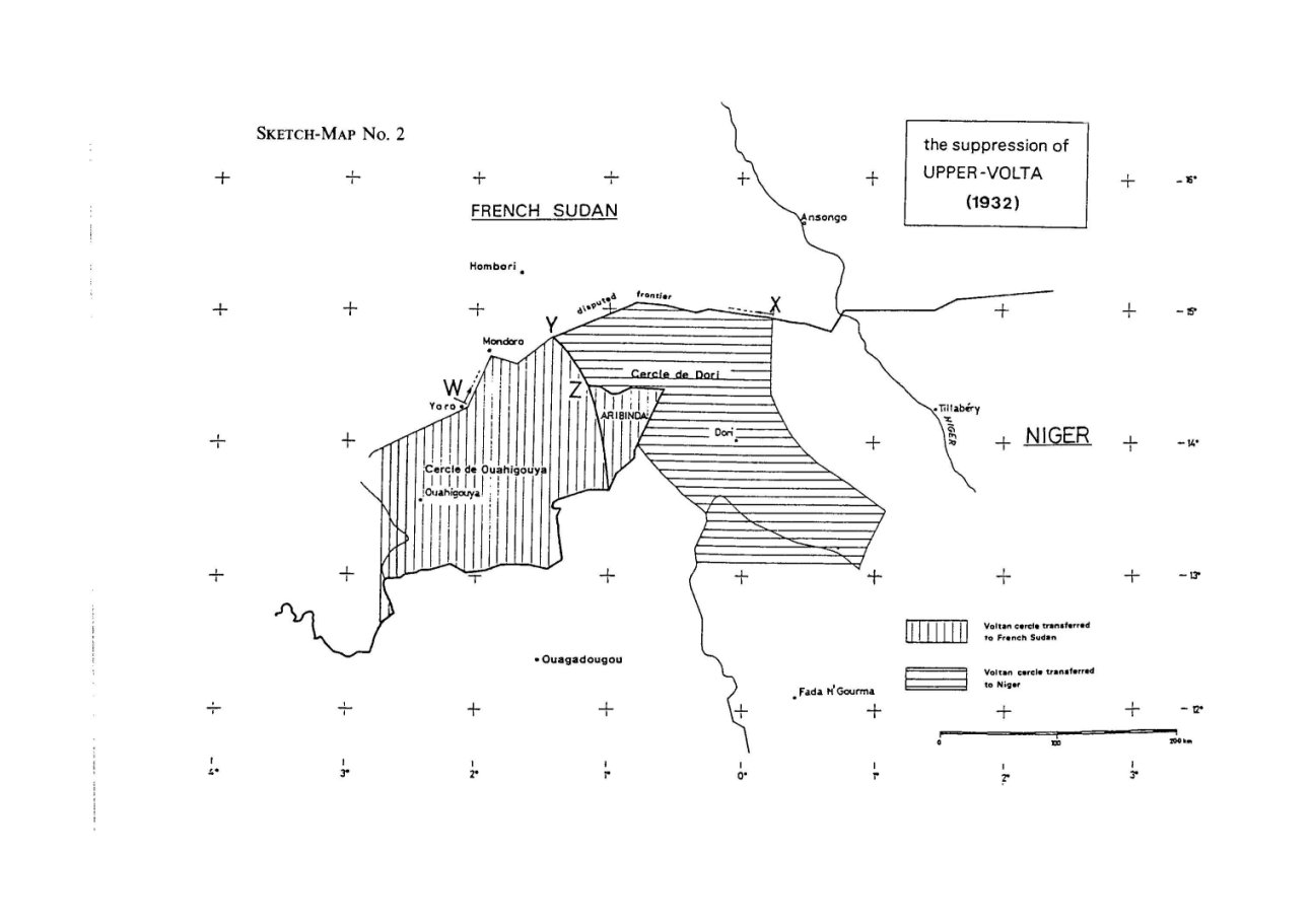
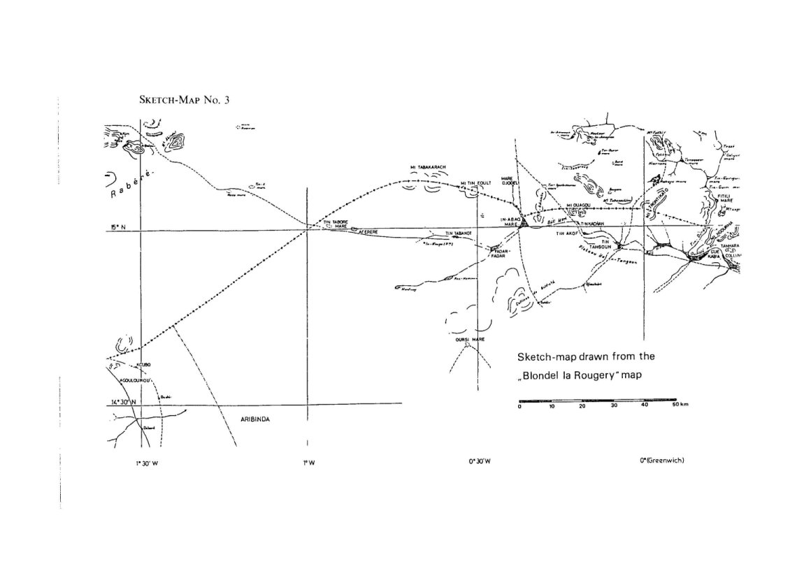
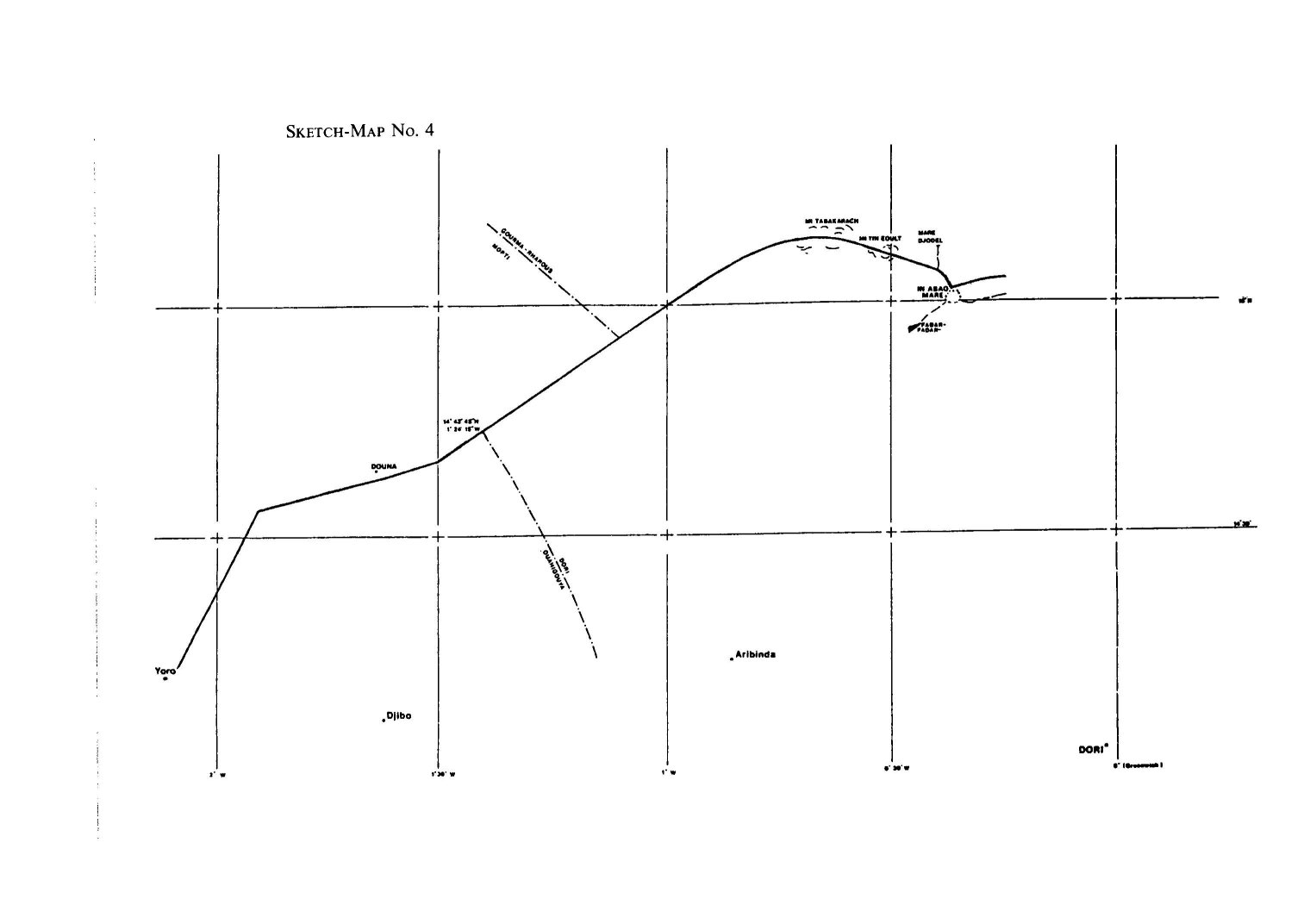
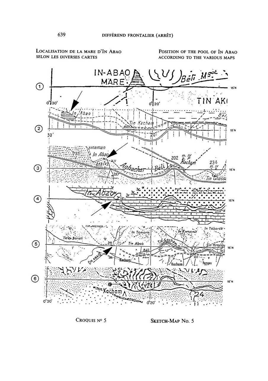
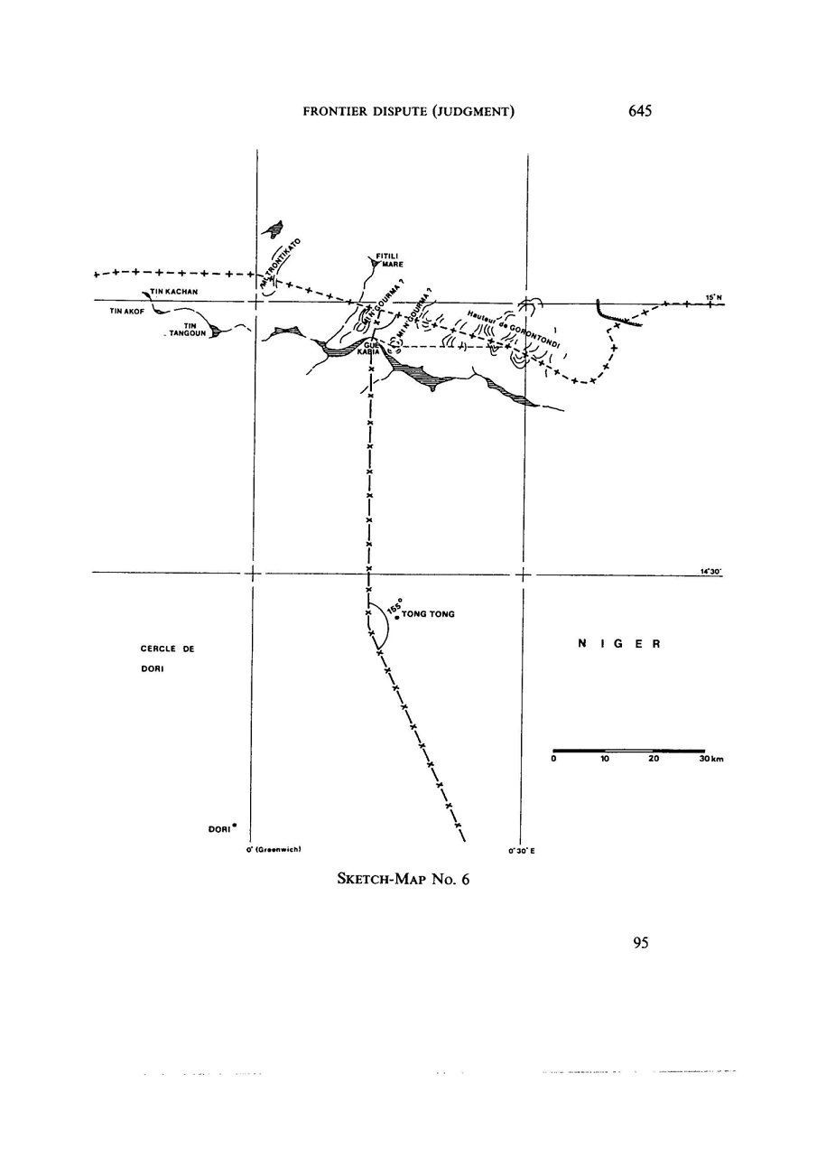