| |
[p246]
The Chamber of the International Court of Justice formed to deal with the
case above mentioned,
composed as above,
after deliberation, [p252]
delivers the following Judgment:
1. By a joint letter dated 25 November 1981, filed in the Registry of the
Court the same day, the Ambassador of Canada to the Netherlands and the
Ambassador of the United States of America to the Netherlands transmitted to
the Registrar a certified copy of a Special Agreement dated 29 March 1979,
and subsequently modified, by which Canada and the United States of America
agreed to submit to a Chamber of the Court, composed of five persons, to be
constituted pursuant to Article 26, paragraph 2, and Article 31 of the
Statute of the Court, and in accordance with the Special Agreement, a
question as to the course of the single maritime boundary that divides the
continental shelf and fisheries zones of the two Parties in the Gulf of
Maine area. By the same letter, the Government of Canada also notified the
Court, in accordance with Article 35 of the Rules of Court, of its intention
to exercise the power conferred by Article 31 of the Statute of the Court to
choose a judge ad hoc.
2. By a letter dated 18 December 1981, the Acting President of the Court
requested the Agents of both Parties to submit to the Court, in writing,
supplementary explanations or clarifications on a number of points relating
to, inter alia, certain provisions of the Special Agreement. The relevant
explanations or clarifications were given in a letter from the Ambassadors
of both Parties at The Hague, dated 6 January 1982 and filed in the Registry
on 8 January 1982.
3. By an Order dated 20 January 1982, the Court, having considered the
above-mentioned letter, was of the opinion that the replies contained in it
were to be read together with the terms of the Special Agreement for the
purposes of this case, and decided to accede to the request of the
Governments of Canada and the United States of America to form a special
Chamber of five judges to deal with the case, declared that Judges Gros,
Ruda, Mosler, Ago and Schwebel had been elected to the Chamber, noted that
the Acting President of the Court, in exercise of his powers under Article
31, paragraph 4, of the Statute of the Court, had requested Judge Ruda to
give place in due course to the judge ad hoc to be chosen by the Government
of Canada, and that Judge Ruda had indicated his readiness to do so, and
declared that a Chamber to deal with the case had been duly constituted by
the Order with the composition indicated therein.
4. By a letter dated 26 January 1982, the Ambassador of Canada at The Hague,
referring to Article 31 of the Statute and Article 35 of the Rules of Court,
informed the Court that the person chosen by Canada to sit as judge ad hoc
in the case was Professor Maxwell Cohen ; by a letter from the Agent of the
United States dated 26 January 1982 the Court was informed that the United
States had no observations to make on that choice.
5. The text of the Special Agreement of 29 March 1979 is as follows:
"The Government of Canada and the Government of the United States of
America,
Recognizing that they have been unable to resolve by negotiation the
differences between them concerning the delimitation of the continental
shelf and the fisheries zones of Canada and the United States of America in
the Gulf of Maine area,
Desiring to reach an early and amicable settlement of these differences, [p253]
Have agreed as follows :
Article 1
The Parties shall submit the question posed in Article II to a Chamber of
the International Court of Justice, composed of five persons, to be
constituted after consultation with the Parties, pursuant to Article 26 (2)
and Article 31 of the Statute of the Court and in accordance with this
Special Agreement.
Article II
1. The Chamber is requested to decide, in accordance with the principles and
rules of international law applicable in the matter as between the Parties,
the following question :
What is the course of the single maritime boundary that divides the
continental shelf and fisheries zones of Canada and the United States of
America from a point in latitude 44° 11' 12" N, longitude 67° 16' 46" W to a
point to be determined by the Chamber within an area bounded by straight
lines connecting the following sets of geographic coordinates : latitude 40°
N, longitude 67° W ; latitude 40° N, longitude 65° W ; latitude 42° N,
longitude 65° W ?
2. The Chamber is requested to describe the course of the maritime boundary
in terms of geodetic lines, connecting geographic coordinates of points. The
Chamber is also requested, for illustrative purposes only, to depict the
course of the boundary on Canadian Hydrographic Service Chart No. 4003 and
United States National Ocean Survey Chart No. 13006, in accordance with
Article IV.
3. The Parties shall request the Chamber to appoint a technical expert
nominated jointly by the Parties to assist it in respect of technical
matters and, in particular, in preparing the description of the maritime
boundary and the charts referred to in paragraph 2. The Registrar is
requested to provide the expert with copies of each Party's pleadings when
such pleadings are communicated to the other Party. The expert shall be
present at the oral proceedings and shall be available for such
consultations with the Chamber as it may deem necessary for the purposes of
this Article.
4. The Parties shall accept as final and binding upon them the decision of
the Chamber rendered pursuant to this Article.
Article III
1. South and West of the maritime boundary to be determined by the Chamber
in accordance with this Special Agreement Canada shall not, and north and
east of said maritime boundary the United States of America shall not, claim
or exercise sovereign rights or jurisdiction for any purpose over the waters
or seabed and subsoil.
2. Nothing in this Special Agreement shall affect the position of either
Party with respect to the legal nature and seaward extent of the continental
[p254] shelf, of fisheries jurisdiction, or of sovereign rights or
jurisdiction for any other purpose under international law.
Article IV
The Chamber and any technical expert or experts are requested to utilize,
and the Parties in their presentations to the Chamber shall utilize, the
following technical provisions :
(a) All geographic coordinates of points referred to shall be rendered on
the 1927 North American Datum.
(b) All straight lines shall be geodetic lines. Curved lines, including
parallels of latitude, if necessary for the judgment, shall be computed on
the 1927 North American Datum.
(c) Notwithstanding the fact that the Parties utilize different vertical
datums in the Gulf of Maine area, the two datums shall be deemed to be
common.
(d) Should reference to the low water baseline of either Party be required,
the most recent largest scale charts published by the Party concerned shall
be utilized.
(e) If a point or points on a particular chart are not on the 1927 North
American Datum, the Chamber shall request the Agent of the appropriate Party
to furnish the Chamber with the corrected datum points.
(f) In recognition of the fact that the Parties do not utilize the same
standard set of symbols on nautical charts, the Chamber, or any technical
expert or experts shall, if necessary, confer with the Agents and their
advisers to insure proper interpretation of the symbol or feature.
(g) The Chamber, or any technical expert or experts, is requested to consult
with the Parties as may be necessary concerning any common computer programs
of the Parties for technical calculations, and to utilize such programs as
appropriate.
Article V
1. Neither Party shall introduce into evidence or argument, or publicly
disclose in any manner, the nature or content of proposals directed to a
maritime boundaries settlement, or responses thereto, in the course of
negotiations or discussions between the Parties undertaken since 1969.
2. Each of the Parties shall notify and consult the other prior to
introducing into evidence or argument diplomatic or other confidential
correspondence between Canada and the United States of America related to
the issue of maritime boundaries delimitation.
Article VI
1. Without prejudice to any question as to burden of proof, the Parties
shall request the Chamber to authorize the following procedure with regard
to the written pleadings : [p255]
(a) a Memorial to be submitted by each Party not later than seven months
after the Registrar shall have received the notification of the name or
names of the judge or judges ad hoc ;
(b) a Counter-Memorial to be submitted by each Party not later than six
months after the exchange of Memorials ; and
(c) any further pleadings found by the Chamber to be necessary.
2. The Chamber may extend these time-limits at the request of either Party.
3. The written pleadings submitted to the Registrar shall not be
communicated to the other Party until the corresponding pleading of that
Party has been received by the Registrar.
Article VII
1. Following the decision of the Chamber, either Party may request
negotiations directed toward reaching agreement on extension of the maritime
boundary as far seaward as the Parties may consider desirable.
2. If the Parties have not reached agreement on the extension of the
maritime boundary within one year of the date of such a request, either
Party may notify the other of its intention to submit the question of the
seaward extension of the maritime boundary for decision by a binding third
party settlement procedure.
3. If the Parties are unable to agree on the terms of such a submission
within three months of such a notification, either Party may submit the
question of the seaward extension of the maritime boundary to the Chamber of
five judges constituted in accordance with this Special Agreement.
4. The provisions of this Special Agreement shall be applied, mutatis
mutandis, to the proceedings under this Article, and the decision of the
Chamber shall be final and binding upon the Parties.
Article VIII
This Special Agreement shall enter into force on the date of the entry into
force of the Treaty between the Government of Canada and the Government of
the United States of America to Submit to Binding Dispute Settlement the
Delimitation of the Maritime Boundary in the Gulf of Maine Area signed this
day. It shall remain in force unless and until it is terminated in
accordance with the provisions of the said Treaty or until the said Treaty
is terminated."
6. Pursuant to Article 40, paragraph 3, of the Statute and to Article 42 of
the Rules of Court, copies of the notification and Special Agreement were
transmitted to the Secretary-General of the United Nations, the Members of
the United Nations and other States entitled to appear before the Court.
7. By an Order made by the Court on 1 February 1982 pursuant to Article 92
of the Rules of Court, and thereafter by Orders made by the President of the
Chamber on 28 July 1982, 5 November 1982, and 27 July 1983, time-limits were
fixed or extended for the filing of Memorials and Counter-Memorials, and the
filing of Replies was found to be necessary and a time-limit fixed therefor.
The [p256] Memorials, Counter-Memorials and Replies of the Parties were
duly filed within the time-limits so fixed or extended.
8. By an Order made by the Chamber on 30 March 1984 Commander Peter Bryan
Beazley was appointed as technical expert to assist the Chamber in respect
of technical matters and, in particular, in preparing the description of the
maritime boundary and the charts referred to in Article II, paragraph 2, of
the Special Agreement. Before taking up his duties, the technical expert
made a solemn declaration, the text of which was set out in the Order.
9. On 2-6, 10-13, 16, 18-19 April and 3-5 and 9-11 May 1984, the Chamber
held public sittings at which it was addressed by the following
representatives of the Parties :
|
For
Canada: |
H.E.
Mr. L. H. Legault, |
|
|
The
Hon. Mr. M. MacGuigan, P.C., Q.C., M.P., |
|
|
Mr.
B. Hankey, |
|
|
Mr.
W. I. C. Binnie, Q.C., |
|
|
Mr.
Y. Fortier, Q.C., |
|
|
Mr.
I. Brownlie, Q.C., |
|
|
Mr.
D. W. Bowett, Q.C., |
|
|
Mr.
P. Weil, |
|
|
Mr.
A. Malintoppi, |
|
|
Mr.
G. Jaenicke.
|
|
For
the United States of America : |
The
Hon. Mr. D. R. Robinson, |
|
|
Mr.
J. R. Stevenson, |
|
|
Mr.
D. Colson, |
|
|
Mr.
M. Feldman, |
|
|
Mr.
K. Lancaster, Mr. K. Lancaster, |
|
|
Mr.
B. Rashkow, |
|
|
Mr.
S. Riesenfeld. |
The Government of the United States called an expert, Mr. R. Edwards, who
was questioned by Mr. Lancaster, counsel for the United States, and Mr.
Fortier, counsel for Canada.
10. In the course of the hearings questions were put to both Parties by
members of the Chamber. Prior to the close of the hearings, oral or written
replies to those questions were given by the Agents or counsel of the
Parties.
11. The Governments of the United Kingdom and Bangladesh, in reliance on
Article 53, paragraph 1, of the Rules of Court, asked to be furnished with
copies of the pleadings and annexed documents in the case. By letters of 6
and 13 December 1982, after the views of the Parties had been sought, and
objection made by them, the Registrar informed those Governments that the
President of the Chamber had decided that it would not be appropriate to
grant the requests of those two Governments at that time. On 2 April 1984
the Chamber decided, after ascertaining the views of the Parties pursuant to
Article 53, paragraph 2, of the Rules of Court, that the pleadings and
annexed documents should be made accessible to the public, and available to
third States, with effect from the opening of the oral proceedings, and they
were thus at the same time made available to the States mentioned above.
*[p257]
12. In the course of the written proceedings, the following Submissions were
presented by the Parties :
On behalf of Canada,
in the Memorial:
"In view of the facts and arguments set out in this Memorial,
May it please the Court to declare and adjudge that:
The course of the single maritime boundary referred to in the Special
Agreement concluded by Canada and the United States on 29 March 1979 is
defined by geodetic lines connecting the following geographical coordinates
of points :
44° 11' 12" N 67° 16' 46" W
44° 08' 51" N 67° 16' 20" W
43° 59' 12" N 67° 14' 34" W
43° 49' 49" N 67° 12' 30" W
43° 49' 29" N 67° 12' 43" W
43° 37' 33" N 67° 12' 24" W
43° 03' 58" N 67° 23' 55" W
42° 54' 44" N 67° 28' 35" W
42° 20' 37" N 67° 45' 36" W
41° 56' 42" N 67° 51' 29" W
41° 22' 07" N 67° 29' 09" W
40° 05' 36" N 66° 41' 59" W”;
in the Counter-Memorial:
"In view of the facts and arguments set out in the Canadian Memorial and in
this Counter-Memorial,
May it please the Court, rejecting al1 contrary claims and Submissions set
forth in the United States Memorial,
To declare and adjudge that:
The course of the single maritime boundary referred to in the Special
Agreement concluded by Canada and the United States on 29 March 1979 is
defined by geodetic lines connecting the following geographical coordinates
of points :"
[here follows a list of coordinates identical to those in the Memorial] ;
in the Reply :
"In view of the facts and arguments set out in the Canadian Memorial, the
Canadian Counter-Memorial and in this Reply,
May it please the Court, rejecting al1 contrary claims and Submissions set
forth in the United States Memorial and Counter-Memorial,
To declare and adjudge that:
The course of the single maritime boundary referred to in the Special
Agreement concluded by Canada and the United States on 29 March 1979 is
defined by geodetic lines connecting the following geographical coordinates
of points :"
[here follows a list of coordinates identical to those in the Memorial]. [p258]
On behalf of the United States,
in the Memorial:
"In view of the facts set forth in Part 1 of this Memorial, the statement of
the law contained in Part II of this Memorial, and the application of the
law to the facts as stated in Part III of this Memorial;
Considering that the Special Agreement between the Parties requests the
Court, in accordance with the principles and rules of international law
applicable in the matter as between the Parties, to decide the course of the
single maritime boundary that divides the continental shelf and fisheries
zones of the United States of America and Canada from a point in latitude
44° 11' 12" N, longitude 67°16' 46" W to a point to be determined by this
Court within an area bounded by straight lines connecting the following sets
of coordinates : latitude 40° N, longitude 67° W ; latitude 40° N, longitude
65° W ; latitude 42° N, longitude 65° W ;
May it please the Court, on behalf of the United States of America, to
adjudge and declare :
A. Concerning the applicable law
1. That delimitation of a single maritime boundary requires the application
of equitable principles, taking into account the relevant circumstances in
the area, to produce an equitable solution.
2. That the equitable principles to be applied in this case include :
(a) the principle that the delimitation respect the relationship between the
relevant coasts of the Parties and the maritime areas lying in front of
those coasts, including nonencroachment, proportionality, and, where
appropriate, natural prolongation ;
(b) the principle that the delimitation facilitate conservation and
management of the natural resources of the area ;
(c) the principle that the delimitation minimize the potential for disputes
between the Parties ; and
(d) The principle that the delimitation take account of the relevant
circumstances in the area.
3. That the equidistance method is not obligatory on the Parties or
preferred, either by treaty or as a rule of customary international law, and
that any method or combination of methods of delimitation may be used that
produces an equitable solution.
B. Concerning the relevant circumstances to be taken into account
1. That the relevant geographical circumstances in the area include :
(a) the broad geographical relationship of the Parties as adjacent States ;
(b) the general northeastern direction of the east Coast of North America,
both within the Gulf of Maine and seaward of the Gulf ; [p259]
(c) the location of the international boundary terminus in the northern
corner of the Gulf of Maine ;
(d) the radical changes in the direction of the Canadian coast beginning at
the Chignecto Isthmus, 147 miles northeast of the international boundary
terminus ;
(e) the protrusion of the Nova Scotia peninsula 100 nautical miles southeast
of the international boundary terminus, creating a short Canadian coastline
perpendicular to the general direction of the coast, and across from the
international boundary terminus ;
(f) the concavity in the coast created by the combination of the protrusion
of the Nova Scotia peninsula and the curvature of the New England coast;
(g) the relative length of the relevant coastlines of the Parties ; and
(h) the Northeast Channel, Georges Bank, and Browns Bank and German Bank on
the Scotian Shelf, as special features.
2. That the relevant environmental circumstances in the area include :
(a) the three separate and identifiable ecological régimes associated,
respectively, with the Gulf of Maine Basin, Georges Bank, and the Scotian
Shelf; and
(b) the Northeast Channel as the natural boundary dividing not only separate
and identifiable ecological régimes of Georges Bank and the Scotian Shelf,
but also most of the commercially important fish stocks associated with each
such régime.
3. That the relevant circumstances in the area relating to the predominant
interest of the United States as evidenced by the activities of the Parties
and their nationals include :
(a) the longer and larger extent of fishing by United States fishermen since
before the United States became an independent country ;
(b) the sole development, and, until recently, the almost exclusive
domination of the Georges Bank fisheries by United States fishermen ; and
(c) the exercise by the United States and its nationals for more than 200
years of the responsibility for aids to navigation, search and rescue,
defense, scientific research, and fisheries conservation and management.
C. Concerning the delimitation
1. That the application of equitable principles taking into account the
relevant circumstances in the area to produce an equitable solution is best
accomplished by a single maritime boundary that is perpendicular to the
general direction of the coast in the Gulf of Maine area, commencing at the
starting point for delimitation specified in Article II of the Special
Agreement and proceeding into the triangle described in that Article, but
adjusted during its course to avoid dividing German Bank and Browns Bank,
both of which would be left in their entirety to Canada. [p260]
2. That the boundary should consist of geodetic lines connecting the
following geographic coordinates:
|
Latitude (North)
|
Longitude (West) |
|
(a) |
44°11' 12" |
67°
16' 46" |
|
(b) |
43°
29' 06" |
66°
34' 30" |
|
(c) |
43°
19' 30" |
66°
52' 45" |
|
(d) |
43°
00' 00" |
66°
33' 21" |
|
(e) |
42°
57' 13" |
66°
38' 36" |
|
(f) |
42°
28' 48" |
66°
10' 25" |
|
(g) |
42°
34' 24" |
66°
00' 00" |
|
(h) |
42°
15' 45" |
65°
41' 33" |
|
(i) |
42°
22' 23" |
65°
29' 12" |
|
(j) |
41°
56' 21" |
65°
03' 48" |
|
(k) |
41°
58' 24" |
65°
00' 00"" ; |
in the Counter-Memorial:
"In view of the facts set forth in Part 1 of the United States Memorial and
this Counter-Memorial, the statement of the law contained in Part II of the
United States Memorial and this Counter-Memorial, and the application of the
1aw to the facts as stated in Part III of the United States Memorial and of
this Counter-Memorial;"
[here follow the identical submissions set out in the Memorial] ;
in the Reply :
"In view of the facts set forth in the United States Memorial,
Counter-Memorial, and this Reply, the statement of the law contained in the
United States Memorial, Counter-Memorial, and this Reply, and the
application of the law to the facts as stated in the United States Memorial,
Counter-Memorial, and this Reply;"
(here follow the identical submissions set out in the Memorial].
13. In the course of the oral proceedings, the following submissions were
presented by the Parties :
On behalf of Canada,
at the hearing of 5 May 1984 (afternoon):
"In view of the facts and arguments set out in the Canadian Memorial,
Counter-Memorial and Reply, and by Canada in these oral proceedings,
May it please the Court, rejecting all contrary claims and Submissions set
forth in the United States Memorial, Counter-Memorial and Reply, and by the
United States in these oral proceedings,
To declare and adjudge that:
The course of the single maritime boundary referred to in the Special [p261] Agreement concluded by Canada and the United States on 29 March 1979 is
defined by geodetic lines connecting the geographical co-ordinates of points
described in the Submission appended to Canada's Memorial, Counter-Memorial
and Reply" ;
On behalf of the United States of America,
at the hearing of 11 May 1984 :
"In view of the facts, the statement of the law, and the application of the
law to the facts set forth in the United States Memorial, Counter-Memorial,
Reply, and the oral presentations by United States Counsel;
Considering that the Special Agreement between the Parties requests the
Chamber, in accordance with the principles and rules of international law
applicable in the matter as between the Parties, to decide the course of the
single maritime boundary that divides the continental shelf and fisheries
zones of the United States of America and Canada from a point in latitude
44° 11' 12" N, longitude 67° 16' 46" W to a point to be determined by this
Chamber within an area bounded by straight lines connecting the following
sets of coordinates : latitude 40° N, longitude 67° W ; latitude 40° N.
longitude 65° W ; latitude 42° N, longitude 65° W ;
May it please the Chamber, on behalf of the United States of America, to
adjudge and declare :
A. Concerning the applicable law
1. That delimitation of a single maritime boundary requires the application
of equitable principles, taking into account the relevant circumstances in
the area, to produce an equitable solution.
2. That the equitable principles to be applied in this case include :
(a) the principle that the delimitation respect the relationship between the
relevant coasts of the Parties and the maritime areas lying in front of
those coasts, including non-encroachment; proportionality ; and natural
prolongation in its geographic sense, or coastal-front extension ;
(b) the principle that the delimitation facilitate conservation and
management of the natural resources of the area ;
(c) the principle that the delimitation minimize the potential for disputes
between the Parties ; and
(d) the principle that the delimitation take account of the relevant
circumstances in the area.
3. That the equidistance method is not obligatory on the Parties or
preferred, either by treaty or as a rule of customary international law, and
that any method or combination of methods of delimitation may be used that
produces an equitable solution in application of these principles. taking
account of the relevant circumstances. [p262]
B. Concerning the relevant circumstances to be taken into account
1. That the relevant geographical circumstances in the area include :
(a) the extension of the coastal front of Maine and New Hampshire through
the Gulf of Maine and beyond ;
(b) the broad geographical relationship of the Parties as adjacent States ;
(c) the general northeastern direction of the east coast of North America,
both within the Gulf of Maine and seaward of the Gulf ;
(d) the location of the international boundary terminus in the northern
corner of the Gulf of Maine ;
(e) the radical changes in the direction of the Canadian coast beginning at
the Chignecto Isthmus, 147 miles northeast of the international boundary
terminus ;
(f) the protrusion of the Nova Scotia peninsula 100 nautical miles southeast
of the international boundary terminus, creating a short Canadian coastline
perpendicular to the general direction of the coast, and across from the
international boundary terminus ;
(g) the concavity in the coast created by the combination of the protrusion
of the Nova Scotia peninsula and the curvature of the New England coast;
(h) the relative length of the relevant coastlines of the Parties ; and
(i) the Northeast Channel, Georges Bank, and Browns Bank and German Bank on
the Scotian Shelf, as special features.
2. That the relevant environmental circumstances in the area include :
(a) the three separate and identifiable ecological régimes associated,
respectively, with the Gulf of Maine Basin, Georges Bank, and the Scotian
Shelf; and
(b) the Northeast Channel as the natural boundary dividing not only separate
and identifiable ecological régimes of Georges Bank and the Scotian Shelf,
but also most of the commercially important fish stocks associated with each
such régime.
3. That the relevant circumstances in the area relating to the predominant
interest of the United States as evidenced by the activities of the Parties
and their nationals include :
(a) the longer and larger extent of fishing by United States fishermen since
before the United States became an independent country ;
(b) the sole development, and, until recently, the almost exclusive
domination of the Georges Bank fisheries by United States fishermen ; and
(c) the exercise by the United States and its nationals for more than 200
years of the responsibility for aids to navigation, search and rescue,
defense, scientific research, and fisheries conservation and management. [p363]
C. Concerning the delimitation
1. That the application of equitable principles taking into account the
relevant circumstances in the area to produce an equitable solution is best
accomplished by a single maritime boundary that is perpendicular to the
general direction of the Coast in the Gulf of Maine area, commencing at the
starting point for delimitation specified in Article II of the Special
Agreement and proceeding into the triangle described in that Article, but
adjusted during its course to avoid dividing German Bank and Browns Bank,
both of which would be left in their entirety to Canada.
2. That the boundary should consist of geodetic lines connecting the
following geographic coordinates :
|
Latitude (North)
|
Longitude (West) |
|
(a) |
44°
11' 12" |
67°
16' 46" |
|
(b) |
43°
29' 06" |
66°
34' 30" |
|
(c) |
43°
19' 30" |
66°
52' 45" |
|
(d) |
43°
00' 00" |
66°
33' 21" |
|
(e) |
42°
57' 13" |
66°
38' 36" |
|
(f) |
42°
28' 48" |
66°
10' 25" |
|
(g) |
42°
34' 24" |
66°
00' 00" |
|
(h) |
42°
15' 45" |
65°
41' 33" |
|
(i) |
42°
22' 23" |
65°
29' 12" |
|
(j) |
41°
56' 21" |
65°
03' 48" |
|
(k) |
41°
58' 24" |
65°
00' 00".” |
I
14. The case concerning the delimitation of the maritime boundary in the
Gulf of Maine area was brought before the Court on the basis of the first of
the possibilities envisaged under Article 40, paragraph 1, of its Statute,
namely by notification of a special agreement, in this case the Special
Agreement signed at Washington on 29 March 1979 by the Governments of Canada
and of the United States of America and notified to the Court on 25 November
1981.
15. By an Order of 20 January 1982, the Court in application of paragraph 2
of Article 26 and of Article 31 of its Statute, formed a special Chamber
composed of five Members to deal with the case. Under the terms of Article
II, paragraph 1, of the Special Agreement, this Chamber is
"requested to decide, in accordance with the principles and rules of
international law applicable in the matter as between the Parties, the
following question :
What is the course of the single maritime boundary that divides the
continental shelf and fisheries zones of Canada and the United States of
America, from a point in latitude 44° 11' 12" N, longitude 67° 16' 46" W to
a point to be determined by the Chamber within an [p264] area bounded by
straight lines connecting the following sets of geographical co-ordinates :
latitude 40° N, longitude 67° W ; latitude 40° N, longitude 65° W ; latitude
42° N, longitude 65° W?"
16. Article II, paragraph 4, declares that: "The Parties shall accept as
final and binding upon them the decision of the Chamber rendered pursuant to
this Article." Article III, paragraph 1, furthermore confirms the final and
binding character of the "single maritime boundary" to be delimited by the
Chamber, specifying that south and West of this "maritime boundary" Canada
shall not, and north and east of it the United States of America shall not,
"claim or exercise sovereign rights or jurisdiction for any purpose over the
waters or sea-bed and subsoil". It is also to be noted that Article III,
paragraph 2, expressly reserves the positions of each of the two Parties by
providing that:
"Nothing in this Special Agreement shall affect the position of either Party
with respect to the legal nature and seaward extent of the continental
shelf, of fisheries jurisdiction, or of sovereign rights of jurisdiction for
any other purpose under international law."
17. The task of delimitation of the maritime boundary within the limits
indicated under Article II, paragraph 1, is not the only one for which the
Special Agreement makes provision. Article VII, paragraph 1, provides that:
"Following the decision of the Chamber, either Party may request
negotiations directed toward reaching agreement on extension of the maritime
boundary as far seaward as the Parties may consider desirable."
And the following paragraphs provide that if the Parties do not reach
agreement in this connection within specified time-limits, either directly
or by submitting the question for decision by a binding third-party
settlement procedure, either Party may "submit the question of the seaward
extension of the maritime boundary to the Chamber of five judges constituted
in accordance with the Special Agreement" (para. 3). The provisions of the
Special Agreement are then to be applied, mutatis mutandis, to the new
proceedings undertaken in this way and the decision of the Chamber therein
shall also be "final and binding upon the Parties" (para. 4). This question
is, however, unrelated to the determination of the Chamber's jurisdiction in
the present case. Such competence can in principle only derive from the
provisions of the Statute and Rules governing the Court's jurisdiction ; the
application of these provisions is no different whether the Court is sitting
in its full composition or as a Chamber. As for the Special [p265]
Agreement, it defines no limitation of the jurisdiction of the Chamber other
than that resulting from the very terms of the question set forth in Article
II, paragraph 1, which will be studied further below.
18. The Special Agreement (Art. II, para. 3) requests the Chamber to appoint
a technical expert nominated jointly by the Parties to assist it in respect
of technical matters and, in particular, in preparing the description of the
maritime boundary and the charts on which its course has to be indicated.
The technical expert was in fact appointed by an Order of 30 March 1984 and
the conditions laid down for his participation in the work of the Chamber
have duly been complied with. Otherwise, the Special Agreement requests the
Chamber and the expert to comply with certain technical provisions, set
forth under Article IV, (a) to (g), and imposes upon the Parties certain
restrictions in regard to evidence and argument (Art. V).
19. The Court, and consequently the Chamber, having been seised by means of
a special agreement, no preliminary question arises in regard to its
jurisdiction to deal with the case. A question might conceivably arise as a
result of the use, at least in the French text of the Special Agreement, of
the term fronrière maritime ("maritime boundary"), which might suggest,
incorrectly, the idea of a real frontière (boundary) between two sovereign
States. However, it is clear to the Chamber that the task which it has been
given only relates to a delimitation between the different forms of partial
jurisdiction, i.e., the "sovereign rights" which, under current
international law, both treaty-law and general law, coastal States are
recognized to have in the marine and submarine areas lying outside the outer
limit of their respective territorial seas, up to defined limits. The rights
of third States in the areas in question cannot therefore be in any way
affected by the delimitation which the Chamber is required to effect. Apart
from this consideration, the only problem which may theoretically arise at
the outset in this context could be how far the Chamber is obliged to abide
by the provisions of the Special Agreement in regard to the starting-point
of the delimitation line to be drawn and the triangle within which this line
is to end.
20. According to the information provided by the Parties themselves, the
starting-point in question (44° 11' 12" north, 67° 16' 46" west), called
point A, is simply the first point of intersection of the two lines
representing the limits of the fishing zones respectively claimed by Canada
and the United States when, at the end of 1976, and with effect from the
beginning of 1977, they decided upon the extension of their fisheries
jurisdiction up to 200 nautical miles. The reason for choosing this point of
intersection - rather than the international boundary terminus fixed under
the Treaty between the two States dated 24 February 1925, and situate in the
Grand Manan Channel, which might have seemed more logical - is that to
seaward of this last-mentioned point are Machias Seal Island and North Rock,
the sovereignty over which is in dispute, and that the Parties wish to
reserve for themselves the possibility of a direct solution [p266] of this
dispute. It would seem that the choice of point A was influenced by no other
consideration apart from that indicated above.
21. As to the triangle enclosing the area within which the delimitation line
to be drawn by the Chamber is to terminate, according to the Parties it was
established to avoid the possibility of the Chamber's decision in this case
prejudging such questions as that of the determination of the outer edge of
the continental margin, questions to be dealt with by negotiations in the
first instance. It goes without saying that the position and limits of the
triangle were established in the light of the respective claims of the
Parties at the time when the Special Agreement was concluded, namely in
1979. But even at present, the lines representing the maximum claims of the
two Parties still terminate within the triangle - close to the northeast
apex and the southwest apex, respectively.
22. The application of the rules of international law and the methods of
delimitation considered the most appropriate in this case might present the
Chamber with the temptation to adopt another starting-point of the line to
be drawn, or to draw a line terminating at a point outside the triangle.
However, even disregarding the somewhat improbable nature of this
hypothesis, the decisive reason why such solutions should not be pursued is
the fact that for the delimitation of a maritime boundary — whether it
concern the territorial sea or the continental shelf or the exclusive
economic zone — both conventional and customary international law accord
priority over al1 others to the criterion that this delimitation must above
all be sought, while always respecting international law, through agreement
between the parties concerned. Recourse to delimitation by arbitral or
judicial means is in the final analysis simply an alternative to direct and
friendly settlement between the parties.
23. If therefore Canada and the United States of America have chosen to
reserve for themselves, as the subject of future direct negotiation with a
view to an agreement, the determination of the course of the delimitation
line between the international boundary terminus and point A, and the course
of the delimitation beyond the end-point of the Chamber's line in the
triangle, it must be concluded that their intention otherwise to have
recourse to judicial settlement must be taken within the limits in which it
was conceived and expressed. The two States have already, by mutual
agreement, taken a step towards a solution of their dispute, which does of
course require to be supplemented by a decision of the Chamber, but which
should nevertheless not be disregarded by it. The Chamber concludes that, in
the task conferred upon it, it must conform to the terms by which the
Parties have defined this task. If it did not do so, it would overstep its
jurisdiction.
24. There is a profound difference, in two important respects, between the
requests submitted by the Parties in the cases previously brought before [p267] the Court, namely those relating to the delimitation of the North Sea
Continental Shelf and the delimitation of the Continental Shelf (Tunisia/
Libyan Arab Jamahiriya), and the request currently submitted to the judgment
of the Chamber and relating to the delimitation to be effected in the Gulf
of Maine area.
25. To begin with, in the other cases just mentioned, the Court was not
required to draw a line of delimitation itself, but merely to undertake a
task preliminary to the determination of such a line, i.e., to indicate the
principles and rules of international law applicable to that delimitation,
to which, in the Tunisia/Libya case, was added the request that the Court
should clarify the practical method for the application of these principles
and rules in the specific situation. The Parties had reserved for themselves
the final task, namely the determination of the delimitation line, to be
undertaken jointly and on the binding basis of the indications received from
the Court. However, in the present case, this task is directly entrusted to
the Chamber, without any indication being given in the Special Agreement as
to the sources from which it should derive its determination of applicable
principles and methods. Seen from this first aspect, the request submitted
to the Chamber is analogous rather to the request made to the Court of
Arbitration which was asked to draw the delimitation line of the continental
shelf between France and the United Kingdom.
26. The second aspect which distinguishes this case from al1 those
previously adjudicated is the fact that, for the first time, the
delimitation which the Chamber is asked to effect does not relate
exclusively to the continental shelf, but to both the continental shelf and
the exclusive fishing zone, the delimitation to be by a single boundary.
Moreover, during the oral proceedings, the Parties added — by reference to
Article III, paragraph 1, of the Special Agreement — that the single
boundary line to be drawn should be applicable to all aspects of the
jurisdiction of the coastal State, not only jurisdiction as defined by
international law in its present state, but also as it will be defined in
future. In order to determine this single boundary, the Chamber is only
asked to decide "in accordance with the principles and rules of
international law applicable in the matter as between the Parties", without
there being any additional indication, whether of a formal or substantial
character, given in the text of the Special Agreement with regard to these
"rules and principles".
27. With regard to this second aspect, the Chamber must observe that the
Parties have simply taken it for granted that it would be possible, both
legally and materially, to draw a single boundary for two different
jurisdictions. They have not put forward any arguments in support of this
assumption. The Chamber, for its part, is of the opinion that there is
certainly no rule of international law to the contrary, and, in the present
case, there is no material impossibility in drawing a boundary of this kind.
There can thus be no doubt that the Chamber can carry out the operation
requested of it. [p268]
II
28. The area within which the delimitation sought in the present case is to
be carried out, in other words, the geographical area directly concerned in
this delimitation, lies within the ill-defined limits of what the Parties
have, in the title and preamble of the Special Agreement, called the "Gulf
of Maine area" — without, however, there giving any definition of this
expression. The Chamber considers it indispensable to achieve a greater
degree of precision as to the geographical concepts used in this context by
way of basis for the operation which it has to perform.
29. As can be seen from the maps inserted or appended to the present
Judgment, the Gulf of Maine properly so called is a broad oceanic
indentation in the eastern coast of the North American Continent, having
roughly the shape of an elongated rectangle. At its southwestern end, once
past Nantucket Island, the elbow of Cape Cod is reached ; from here on, the
indentation follows the approximately north-south segment at the end of this
peninsula. Within the peninsula and the imaginary line linking its tip with
Cape Ann further to the north are the two contiguous bays of Cape Cod and
Massachusetts. At the back of Massachusetts Bay is the city of Boston. The
characteristic of the western side of the above-mentioned rectangle, which
is one of its two short sides, is the general
south-south-east/north-north-west direction of the Massachusetts coast
abutting on the Gulf of Maine.
30. There then follows the short New Hampshire coastline and, with it, the
direction of the coast of the Gulf begins slightly to alter course, bending
gently towards the north-east. This trend continues with the first segment
of the Maine coastline. But soon the coast of this State, which becomes
broken and fringed with islands, bends again to pursue a steady course
west-south-west/east-north-east. From Cape Elizabeth to the international
boundary between the United States of America and Canada, which terminates
in the Grand Manan Channel, the coast of Maine forms along this line the
first of the long sides of the rectangle. It should be noted that beyond
that frontier the adjacent coast of the province of New Brunswick also
follows the same direction. But between this coast and the coast of Nova
Scotia, which lies opposite and runs almost parallel to it, is the opening
of the Bay of Fundy — more or less at the latitude of the international
boundary terminus — cutting deep inland. The waters of the Bay of Fundy
merge with those of the Gulf in the stretch of sea between Grand Manan
Island, off the coast of New Brunswick, and Brier Island, the prolongation
of Digby Neck and Long Island, which run along the northern coast of Nova
Scotia.
31. The question has been raised whether the Bay of Fundy should be
considered to be a part of the Gulf of Maine or whether this bay should be
regarded as a closed bay, considered as though it were sealed off by a
straight line. The fact that such a line may be taken into consideration in
constructing the rectangle within the Gulf to define its geometric form in
[p269]
Map No. 1
[p270] order to facilitate the search for a delimitation line does not mean
that the closing line is no longer an imaginary line drawn across the waters
but becomes a real coastal line. Nor does it mark a separation of the waters
on each side of it: judging by the evidence presented, there is no
appreciable difference in quality between the waters in the north-east part
of the Gulf and the waters in the outer part of the Bay. In fact, the part
of the Bay which is closest to its opening into the Gulf is wide, the depth
of the waters is the same, and the distance between the mainland coasts
exceeds twice the extent of the territorial sea. However, further into the
Bay, the water is less deep, and the shores are closer together so that the
Bay contains only maritime areas lying no further than 12 miles from the low
water mark.
32. Almost opposite the international boundary terminus, the coast of Nova
Scotia swings sharply round in an overall south-easterly direction, so that
if the line of this direction were extended back in the opposite direction,
it would meet the line of the coast of Maine, described in paragraph 30
above, at almost a right angle. The imaginary line which runs from the
international boundary terminus across the Canadian island called Grand
Manan Island to Brier Island and Cape Sable at the two extremities of Nova
Scotia, forms the second — eastern — short side of the rectangle, opposite
to the western side formed by the coast of Massachusetts. The quasi-parallel
direction of these two opposite coasts is striking ; the distance between
Cape Ann and Whipple Point on Brier Island is 206 miles, that between the
nearest point on Cape Cod and Chebogue Point on the coast of Nova Scotia is
201 miles, and that between the elbow of Cape Cod and Cape Sable is barely
more (219 miles).
33. The second long side of the rectangle does not at any point correspond
to a landmass. It is formed only by an imaginary line drawn across the
waters from the south-eastern point on Nantucket Island, to Cape Sable at
the south-western end of Nova Scotia. The two Parties agree that this is the
seaward "closing line" of the Gulf of Maine. Since this line joins the two
ultimate points on land on each side in the direction of the Atlantic, it
effectively indicates, in the context of the delimitation area, the boundary
between the inner zone, or the Gulf of Maine in the true sense, and the
outer or Atlantic zone of the area in question.
34. To sum up, the Gulf of Maine takes the form of a large, roughly
rectangular indentation, bordered on three sides by land - except where the
contiguous bays of Cape Cod/Massachusetts lie along the western side, and
the Bay of Fundy opens out at the inner end of the eastern side - and on the
fourth side open to the Atlantic Ocean.
35. In the above description of the Gulf of Maine there are several
references to the rectangle which appears to afford a good simplified
representation of the configuration of that Gulf, as outlined by its coasts.
It is on the basis of this approximation to a specific geometrical figure
that [p271] the two opposite terrestrial sides of the Gulf, in essence the
shores of Massachusetts on the one hand and of Nova Scotia on the other,
have thus been presented as the short sides of the rectangle, and the
similar terrestrial side formed by the shores of Maine, which connects the
other two at the back of the Gulf, as the long side.
36. It must nevertheless be made clear that the use of these appellations,
borrowed from the terminology of geometry, must not be interpreted as an
espousal of the idea that some of the coastal fronts of the Gulf of Maine
should be considered as "primary" fronts and others as "secondary", so that
the former would be regarded as of greater importance than the latter for
the purposes of the delimitation to be carried out in the waters off these
coasts. The very legitimacy of such a distinction which, throughout the
case, has been the subject of lengthy debate between the United States,
which supports it, and Canada, which is opposed to it, is very dubious.
Terminology of this kind may of course be employed to bring out any
difference observed between the lengths of certain stretches of coast, when
a maritime area is being described. Yet even so, while it might be logical,
from one particular aspect, to attach importance to such a difference, there
is nothing to preclude the possibility of the so-called "secondary" coasts
being of equal if not of even greater importance than the "primary" coasts
from other aspects. Above al], geographical facts are not in themselves
either primary or secondary : the distinction in question is the expression,
not of any inherent property of the facts of nature, but of a human value
judgment, which will necessarily be subjective and which may Vary on the
basis of the same facts, depending on the perspectives and ends in view. The
same may be said as regards the idea put forward in the course of the
proceedings that certain geographical features are to be deemed aberrant by
reference to the presumed dominant characteristics of an area, coast or even
continent.
37. As in other previous cases, the Parties have repeatedly charged each
other with trying to refashion nature or geography in the case of this or
that feature of the area. It is not possible to accept the United States
claim that the south-westward protrusion of the Nova Scotian peninsula from
the Chignectou isthmus is an anomaly, a geographical distortion to be
treated as such, and to be considered an irregular derogation from the
general south-south-west/ north-north-east trend of the eastern seaboard of
the North American Continent. It is likewise not possible to accept Canada's
claim that the existence of so substantial a peninsula as Cap Cod may be
ignored because it forms a salient on the Massachusetts coast on the western
side of the Gulf of Maine. The Chamber must recall that the facts of
geography are not the product of human action amenable to positive or
negative judgment, but the result of natural phenomena, so that they can
only be taken as they are. [p272]
38. Up to the present reference has been made only to the great expanse of
water within the limits of the Gulf of Maine. Yet that expanse is far from
being the whole of what must be regarded as the delimitation area in this
case. On the contrary, for the purposes of this operation, the part of this
area which includes the whole of the Georges Bank - the main focus of the
dispute - is obviously another maritime expanse, one lying over against the
Gulf of Maine, outside its closing line.
39. Bearing in mind the existence of the triangle mentioned in the question
put to the Chamber in the Special Agreement between the Parties, one must
logically deduce that the delimitation area comprises not only the sea areas
surrounded by the coasts of the Gulf of Maine, but also those lying to
seaward of, and over and against, the Gulf, between bounds converging
towards the outer edges of the triangle, for no delimitation by the Chamber
may go beyond these bounds.
40. The delimitation area as defined in the foregoing paragraphs is not to
be confused with what the Parties - each in their own terms - have called
the "Gulf of Maine area". They have designated as part of this "area" some
portions of the Canadian and American coasts lying outside the Gulf,
portions which they have during the proceedings occasionally described as
"coastal wings" of the Gulf, together of course with the related sea areas.
Thus the eastern coastal wing of the Gulf of Maine has sometimes been the
whole southeastern coast of Nova Scotia as far as Cape Canso, or sometimes
merely part of it as far as Halifax or, more modestly, Lunenburg, according
to the requirements of the particular arguments being put forward by the one
Party or the other. Similarly the name of western coastal wing has been
given to the Atlantic coast either of Massachusetts or of Rhode Island as
far as Newport, or even beyond. It is easy to see from a map how these
extensions tend to produce a shift towards one side or another when it comes
to determining the central axis of the so-called "area". The Parties have
also referred to these coastal wings, one in order to emphasize the
importance for the economy of the neighbouring areas of the fishing
resources of the area to be delimited, or even the economic dependence on
those resources of the populations of the adjoining coastal areas ; the
other for the opposite purpose of highlighting the fact that those areas,
their industries and their general economy draw principally upon other
sources than the relatively remote ones of the area in question.
41. The involvement of coasts other than those directly surrounding the Gulf
does not and may not have the effect of extending the delimitation area to
maritime areas which have in fact nothing to do with it. It is ultimately
only the concept of the delimitation area which is a legal concept, albeit
one developed against the background of physical and political geography. In
contrast, the concept of the "Gulf of Maine area", [p273] as used in the
present proceedings, seems elastic in extent and arbitrary to a degree, a
concept which in any event appertains to what may be called socio-economic
or human geography, rather than to pure geography. Without wishing to deny a
priori that data derived from such domains may be important for certain
purposes, it is obvious that, when it comes to determining the boundaries of
the delimitation area, material from these fields cannot be substituted for
findings dictated on the basis of more appropriate considerations.
42. However, up to this point the Chamber's definition and description of
the delimitation area has only brought out aspects inherent in physical
geography. Political geography has been employed solely for the purpose of
noting the location within the area in question of the international
boundary terminus between the United States and Canada. It had merely to be
made clear that the boundary between the two States - whose historical
development, recounted in the pleadings, is apparently without influence on
the issues to be decided - follows in its final stretches the winding course
of the Saint-Croix River, ending in the estuary of that river, following
which it continues as far as its terminal point in the Grand Manan Channel.
It is this latter point which marks the angle between the long and short
sides of the rectangle which, as we have seen, can be inscribed within the
Gulf of Maine.
43. It should, moreover, be added that the Chamber has only had in mind
physical geography to the extent that its purpose is to describe the
present-day aspect of the land and water surfaces of the globe. In order to
grasp not only the outward aspects but the whole of the characteristic
features of the delimitation area, there still remain to be examined various
aspects of what lies below the surface, rather under the heading of
geo-morphology and ecology than that of geology.
44. With regard to geology, the Chamber must observe that, despite the
efforts made to argue either that there are geological affinities between
the platforms of Georges Bank and Nova Scotia, or that there is a geological
continuity between Georges Bank and Massachusetts, both Parties recognize
that the geological structure of the strata underlying the whole of the
continental shelf of North America, including the Gulf of Main area, is
essentially continuous. They are in fact in agreement that geological
factors are not significant in the present case.
45. As regards the geomorphological aspects, the conclusion that can be
drawn from the studies undertaken and taken into careful consideration by
the Parties in their pleadings is, in sum, the unity and uniformity of the
whole sea-bed, as regards both the underlying shelf of the Gulf of Maine
proper, and the shelf below the ocean beyond the Gulf, right up to the
continental margin, its edge, rise and slope. The continental shelf of the
[p274] whole of this area is no more than an undifferentiated part of the
continental shelf of the eastern seaboard of North America, from
Newfoundland to Florida. According to generally accepted scientific
findings, this shelf is a single continuous, uniform and uninterrupted
physiographical structure, even if here and there it features some secondary
characteristics resulting mainly from glacial and fluvial action. In this
wider context the continental shelf of the area relevant to the present
proceedings may be defined as the natural prolongation of the land mass
around the Gulf of Maine ; neither Party disputes the fact that there is
nothing in this single sea-bed, lacking any marked elevations or
depressions, to distinguish one part that might be considered as
constituting the natural prolongation of the coasts of the United States
from another part which could be regarded as the natural prolongation of the
coasts of Canada. Of course, within this single, uniform expanse of sea-bed
it is possible to pick out features described as shelves, banks, basins,
channels, and the Parties have given a detailed description of these,
occasionally — and very cautiously — seeking in the existence of one or
other of these geomorphological features some support for their respective
positions. These are ultimately a somewhat insignificant body of rugosities,
even if they do influence, and are probably in fact produced by, the water
circulation. But the bathymetric differences between one spot and another -
differences which do not show up on a drawing unless there is great vertical
exaggeration - are not such as to cast doubt on the soundness of the basic
finding that the sea-bed of the delimitation area, as of al1 the
neighbouring area — part of which is covered with thick sedimentary layers
potentially rich in hydrocarbon resources -does not show any trace of any
natural differentiation as between the respective continental platforms of
the two Parties.
46. Even the most accentuated of these features, namely the Northeast
Channel, does not have the characteristics of a real trough marking the
dividing-line between two geomorphologically distinct units. It is quite
simply a natural feature of the area. It might also be recalled that the
presence of much more conspicuous accidents, such as the Hurd deep and Hurd
Deep Fault Zone in the continental shelf which was the subject of the
Anglo-French arbitration, did not prevent the Court of Arbitration from
concluding that those faults did not interrupt the geological continuity of
that shelf and did not constitute factors to be used to determine the method
of delimitation. To return to the sea-bed of the area of delimitation in the
present case, no really abrupt change in the normal declivity of the sea-bed
is found before the vicinity of the hypotenuse of the triangle within which
the end-point of the present delimitation is supposed to be located. It is
only thereabouts that the continental slope descends more or less in
parallel with the general direction of the mainland Coast, abruptly at first
as far as the 1,000 metres isobath, after which the "rise" continues down-[p275]ward, though much more gradually, towards the 2,000 metres isobath and
beyond, towards the abyssal plain.
47. The situation in the present case as regards the sea-bed of the
delimitation area is therefore different from the situation that may prevail
in areas where a natural separation does exist from the factual viewpoint
between the respective continental platforms of the Parties in dispute. From
that angle, the present case is closer to other concrete cases, including
most recently that of the delimitation of the continental shelf between
Tunisia and Libya, i.e., situations characterized, as the Court pointed out
in its Judgment of 24 February 1982, by the absence of "any element which
interrupts the continuity of the continental shelf" common to both Parties
(I.C.J. Reports 1982, p. 58, para. 68). When drawing a legal delimitation
line on such a shelf, there is no choice but to proceed without reference to
any real factor of natural separation of the continental shelf of the two
countries, because no such factors are discernible.
48. In addition to the sea-bed itself there is another component element of
the delimitation area which, with its characteristics, must especially be
taken into account in the present case, namely what the Parties have. in
both their pleadings and their oral arguments, called the "water column".
This term in fact refers to the enormous mass of water covering the whole of
the sea-bed in the area in question. It need hardly be pointed out that this
great mass of water is taken into consideration not as some inert mass, but
as the habitat of an exceptionally extensive wealth of fauna and flora. Even
more, perhaps, than the hydrocarbon potential of the sedimentary basins
under the area, it is the fishing resources of the delimitation area which,
as appears from the proceedings, have led to the extraordinarily acute
divergences of interests of the Parties and the no less strenuous opposition
which each puts up against the claim of the other.
49. But, confining itself for the moment to the mere description of the
distinctive aspects of the aquatic mass or water column reposing on the
sea-bed of the delimitation area, the Chamber considers that it should
concentrate on one of those aspects which seems to be of particular
importance.
50. As stated above, the Parties are basically in agreement that the sea-bed
of the area in question does not feature any genuinely natural divisive
element. Both have had to admit that, from the viewpoint of natural
characteristics, the sea-bed of the Gulf is a single, uniform-looking shelf,
one that also forms part of a larger continental shelf. This concurrence as
to the nature of the sea-bed has no counterpart when it comes to the
superjacent water column. Here Canada, in its successive pleadings and oral
arguments, has laid increasing emphasis on the overall unitary character of
the "water column", in particular from the viewpoint of the distribution of
fishing resources, even though it rightly stresses the existence on Georges
Bank of a main concentration of the biomass and, consequently, of the
reserves of several commercially important species. [p276] Canada's
pleadings acknowledge that there is a distinct ecosystem on Georges Bank,
which is geographically defined by the Great South Channel and the Northeast
Channel. But on the basis of its experts' research it also submits that,
despite the particularly congenial conditions favouring the above-mentioned
concentration, Georges Bank forms part of a continuous oceanic system
belonging to the Nova Scotian biogeographical province. This province,
according to Canada, stretches from Newfoundland to the vicinity of the
coastal alignment between Cape Cod and Nantucket Island. East of the Great
South Channel separating Georges Bank from the Nantucket Shoals the
continuity is said to give way to a transition from northern cold-water
fauna and flora to southern warm-water varieties typical of a different,
Virginian, mid-Atlantic biogeographical province. At any rate, it is only
thereabouts that, according to Canada, any kind of oceano-biological
boundary is discernible ; that boundary, however, would lie at the extreme
western limit of the delimitation area and therefore could not be relevant
to the delimitation that has to be carried out within the area itself.
51. For its part, the United States, on the basis of its own detailed
analysis, detects three identifiable and different oceanographic and
ecological régimes in the waters of the area, each with a particular type of
hydrological circulation, temperature, salinity, density and vertical
stratification and its own type of tidal activity. At al1 levels of the food
chain, says the United States, distinct ecological communities have
developed within these various régimes : that of the Gulf of Maine basin,
that of the Scotian Shelf and that of Georges Bank, this last-mentioned
being linked to that of the Nantucket Shoals. Thus the three ecological
régimes, it is submitted, are divided by natural boundaries, the most
important and clearly apparent of which runs along the Northeast Channel,
which is sometimes over 200 metres deep and which is said in fact to form a
line of separation within the area in the case of most of its commercially
important fish stocks.
52. In this respect it should be observed that the United States. realizing
that this channel does not possess the characteristics of a geological fault
which would make it possible to ascribe to it, under appropriate
circumstances, the function of a natural boundary between distinct areas of
sea-bed, has expounded the thesis that the Northeast Channel forms a
recognizable limit in the marine environment. On that ground. according to
the United States. the Northeast Channel must be seen as a natural boundary
that can serve as a basis for drawing a single maritime delimitation line
valid at one and the same time for the exclusive fishery zone and. if need
be, the exclusive economic zone, as well as for the underlying sea-bed and
subsoil.
53. During the oral proceedings. each Party put up a spirited defence of its
position, one contending for : (a) the non-existence of any natural boundary
in the marine environment within the delimitation area, or at least up to
the south-western limit of that area, and in consequence for the [p277]
natural unity of the area's oceanographic and ecological régime ; the other
for : (6) the existence within the waters of the area of three distinct
provinces separated by dividing lines, the most clearly pronounced of which
is the Northeast Channel separating Georges Bank from the Scotian Shelf ;
however, the result was not such as to clear away al1 doubt, at least as
regards certain of the technical aspects debated.
54. The Chamber is not however convinced of the possibility of discerning
any genuine, sure and stable "natural boundaries" in so fluctuating an
environment as the waters of the ocean, their flora and fauna. It has thus
reached the conviction that it would be vain to seek, in data derived from
the biogeography of the waters covering certain areas of sea-bed, any
element sufficient to confer the property of a stable natural boundary -and
what is more, one serving a double purpose — on a geomorphological accident
which influences superadjacent waters but which is clearly inadequate to be
seen as a natural boundary in respect of the sea-bed itself.
55. The Chamber accordingly considers that the conclusion to be drawn in
respect of the great mass of water belonging to the delimitation area is
that it too essentially possesses the same character of unity and uniformity
already apparent from an examination of the sea-bed, so that, in respect of
the waters too, one must take note of the impossibility of discerning any
natural boundary capable of serving as a basis for carrying out a
delimitation of the kind requested of the Chamber.
56. It must, however, be emphasized that a delimitation, whether of a
maritime boundary or of a land boundary, is a legal-political operation. and
that it is not the case that where a natural boundary is discernible, the
political delimitation necessarily has to follow the same line. But in any
event the problem does not arise in the present instance, since, as we have
noted. there are no geological, geomorphological, ecological or other
factors sufficiently important, evident and conclusive to represent a
single, incontrovertible natural boundary.
57. At this stage the Chamber might consider whether the definition of the
outer limits of the area within which it is called upon to delimit the
single maritime boundary between Canada and the United States, and the
description of its physical aspects as regards both surface and depth, ought
not to be followed by taking into consideration other aspects also. What the
Chamber has in mind here is the human environment. and more particularly its
socio-economic conditions.
58. The Parties did take this course ; they even dealt with those aspects in
extenso. They exchanged lengthy argument on whether the fishermen of one
nationality or the other were first on the scene in the waters of the area.
They argued over the importance of the catches of the fisheries,
particularly those of Georges Bank, for the port activity, ship-building,
food industry and dependent industries of the land areas around the Gulf of
Maine, and of the neighbouring areas. They also argued as to their role for
the food supplies of their populations and for their exports. Comparative
analyses were made of the respective importance of the resources drawn [p278] from those fisheries for what was called the one-dimensional economy of
Lunenburg County and for the diversified, urbanized economy of
Massachusetts. On either side, statistics, tables and graphics were produced
in this connection. On one side, gloomy predictions were put forward
regarding the consequences for the Nova Scotian economy of exclusion of
Canadian fishermen from the Georges Bank fisheries ; the other side
emphasized the deleterious effect on the conservation of the Bank's fish
stocks that would result from failure to ensure a system of single-State
management. The Chamber is bound to point out that the Parties sometimes
gave the impression of over-emphasizing these prospects, for it must not be
forgotten that the institution by these two North American States of a
200-mile exclusive fishery zone only dates back eight years, and that
previously in that zone, which at the time was still high seas, American and
Canadian fishing boats plied their trade alongside large high-sea fishing
fleets from distant countries. And the eviction of the latter - the
justification given for which was the need to avoid the over-fishing to
which their presence contributed - was carried out without apparent concern
for the repercussions on certain coastal areas and industries of the
countries in question.
59. However, the crux of the matter lies elsewhere. It should be emphasized
that these fishing aspects, and others relating to activities in the fields
of oil exploration, scientific research, or common defence arrangements, may
require an examination of valid considerations of a political and economic
character. The Chamber is however bound by its Statute, and required by the
Parties, not to take a decision ex aequo et bono, but to achieve a result on
the basis of law. The Chamber is, furthermore, convinced that for the
purposes of such a delimitation operation as is here required, international
law, as will be shown below, does no more than lay down in general that
equitable criteria are to be applied, criteria which are not spelled out but
which are essentially to be determined in relation to what may be properly
called the geographical features of the area. It will only be when the
Chamber has, on the basis of these criteria, envisaged the drawing of a
delimitation line, that it may and should - still in conformity with a rule
of law - bring in other criteria which may also be taken into account in
order to be sure of reaching an equitable result.
III
60. The dispute between Canada and the United States, now referred to the
Chamber for judgment, is of recent origin - although the United States has
suggested that the dispute could be traced back to the attitude of the
Parties at the time of the Truman Proclamations in 1945. By these
proclamations, published on 28 September 1945, the United States asserted
its [p279] jurisdiction over the natural resources of the continental shelf
under the high seas contiguous to its coasts, and announced the
establishment of conservation zones for the protection of fisheries in
certain areas of the high seas contiguous to the United States. The United
States emphasizes that these Proclamations were shown to Canada in advance
of their being issued and Canada made no objection to them, either then or
since ; and that the United States made it clear at the time that, in its
view, the continental shelf extended to the 100-fathoms depth line. The
Chamber will return to this question in paragraphs 153 ff., below.
61. In fact, this dispute first developed in relation to the continental
shelf of what is now the delimitation area, and did so as soon as
exploration for hydrocarbon resources was begun on each side, particularly
in the subsoil of certain parts of Georges Bank. Exploration for hydrocarbon
resources of the continental shelf in the Gulf of Maine area began in the
1960s. The United States ratified the 1958 Geneva Convention on the
Continental Shelf in 1961 and became a party when it came into force in
1964. Canada, confronted by constitutional difficulties related to its
federal structure, did not ratify the Convention until 1970, so that at the
time its first exploration permits were issued, it was not a party. The
Canadian Government accompanied its ratification by a declaration which the
United States did not accept, but which did not prevent the entry into force
of the Convention as between the two countries. In 1953, the United States
had enacted the Outer Continental Shelf Lands Act, the primary text
governing activities on its continental shelf, but because the status of
Georges Bank as the principal fishing bank on the East Coast raised
important environmental concerns, exploration proceeded slowly and
development has been deferred. The first United States permits for
geophysical exploration in this area were issued in 1964. On the Canadian
side, the first regulations authorizing oil and gas operations in off-shore
areas were issued in 1960 (Canada Oil and Gas Regulations), and in 1964 the
Canadian Government began to issue exploration permits in the Gulf of Maine
area. Canada has made it clear that when issuing such permits, in the
absence of any delimitation of the continental shelf agreed with the United
States, it treated the equidistance line as a working boundary, drawing its
inspiration from Article 6 of the 1958 Convention on the Continental Shelf,
at least to the extent of including, in any permits issued extending to
areas beyond that line, a caveat to the effect that the permit was issued
"subject to the lands contained in the grid areas being Canadian lands".
Before the Chamber, Canada described the delimitation line which it had in
mind, and considered that it had respected, as a "strict equidistance" line.
There is no need to pass comment upon that definition for the time being ;
the Chamber will come back to the point when considering directly the
various methods that could in principle be applied to the delimitation. [p280]
62. The question of the line used by the United States as a working limit in
the direction of Canada for the issue of permits in this area is
controverted between the Parties. Canada has claimed that a de facto
equidistance line was used by the United States Bureau of Land Management
(the so-called "BLM line") or by companies to whom United States permits
were granted (the so-called "company median line"). The United States has
denied that these lines had any officia1 status or even existence. The
Chamber will return to this point in connection with the arguments as to the
relevance of the conduct of the Parties (Section V, paragraphs 126 ff.,
below).
63. In 1965, the issue of Canadian exploration permits gave rise to an
exchange of correspondence, initially between a Mr. Hoffman, whose position
was that of Assistant Director for Lands and Minerals of the United States
Bureau of Land Management of the Department of the Interior, and a Mr. Hunt,
whose position was Chief of the Resources Division of the Department of
Northern Affairs and National Resources of Canada. The correspondence began
with a request by the Bureau of Land Management for information as to the
location of Canadian oil and gas exploratory permits. Reliance has been
placed by Canada on this correspondence as constituting or indicating
acquiescence by or estoppel against the United States ; however the Chamber
will not examine these exchanges at this stage, or discuss the significance
attributed to them during the case by Canada, which has been contested by
the United States. The Chamber will come back to them when examining the
state of the law in force between the Parties. It could not, however, be
said that a dispute had at that time already crystallized between the two
States.
64. On 16 August 1966, the United States Embassy in Ottawa requested
information from the Canadian Department of Mines and Technical Surveys as
to Canadian hydrocarbon exploration on the Pacific Coast and in the Gulf of
Maine area. On 30 August 1966 a reply from the Under Secretary of the
Canadian Department of External Affairs outlined the relevant Canadian
policies and practices and enclosed a map showing the sea-bed area covered
by the Canadian permits, but not indicating whether any activity by Canadian
permittees was in progress or imminent in that area. After certain
diplomatic consultations and contacts in 1966-1968, including a United
States aide-mémoire of 10 May 1968 suggesting that negotiations be opened
and that there be a temporary suspension of activities on the northern half
of Georges Bank, the United States on 5 November 1969 presented a diplomatic
Note requesting a moratorium on minera1 explorations and exploitation on
Georges Bank. That Note contained a forma1 reservation of United States
rights and stated that:
"until the exact location of the United States-Canada Continental Shelf
boundary is agreed upon, the United States cannot acquiesce [p281] in any
Canadian authorization of exploration or exploitation of the natural
resources of the Georges Bank Continental Shelf".
On 1 December 1969, Canada replied observing that the United States had not
previously protested against Canadian oil and gas permits. While accepting
the proposa1 that negotiations on the delimitation of the continental shelf
should be undertaken as suggested by the United States, Canada declined to
agree to a moratorium. The Chamber considers that it was at this stage -
Le., after the American diplomatic Note of 5 November 1969 refusing to
acquiesce in any authorization given by Canada to explore or exploit the
natural resources of Georges Bank, and after Canada's reply of 1 December
1969, refusing, inter alia, to agree to any kind of moratorium — that the
existence of the dispute became clearly established. It may however be
useful to note once again that, at that time, it was still only a dispute
relating to the continental shelf.
65. On 21 February 1970, the United States Government recorded in the
Federal Register that the United States had protested against Canadian
authorizations relating to Georges Bank. Forma1 negotiations between the
United States and Canada on the continental shelf boundary began in Ottawa
on 9 July 1970. The Canadian position was that no special circumstances
existed in the area and the boundary should thus be the equidistance line,
as contemplated by Article 6 of the 1958 Geneva Convention on the
Continental Shelf to which Canada had just become a party. When ratifying
the Convention, Canada had appended a declaration to the effect that. in its
view :
"the presence of an accidental feature such as a depression or channel in a
submerged area should not be regarded as constituting an interruption in the
natural prolongation".
The United States formally objected to this declaration on 16 July 1970. The
United States position in the negotiations asserted the inequitableness of
the equidistance line in view of the existence of special circumstances and
that the boundary should follow the Northeast Channel. No drilling
activities were authorized by either State at this time, but seismic surveys
were carried out on Georges Bank by United States companies in 1968, 1969
and 1975.
66. Various exchanges of diplomatic correspondence took place in 1974. On 18
January 1974, the United States informed Canada (among others) of United
States legislation concerning the American lobster (homarus americanus),
based upon Article 2, paragraph 4, of the 1958 Geneva Convention on the
Continental Shelf (concerning the living resources of the shelf), and gave
notice that fishing for American lobster by foreign nationals on the United
States continental shelf was prohibited. The boundary indicated by [p282]
the United States for purposes of enforcement of this legislation was the
100-fathom contour of Georges Bank, and this line has been referred to in
these proceedings as the "lobster line". In September 1974, however, in
order to improve the prospects for negotiation, the United States informed
Canada that it would not enforce the requirements of the lobster law against
Canadian fishermen. The lobster-protection legislation remained in force
until it was superseded by the declaration of the general 200-mile fishery
zone (paragraph 68, below). On 17 September 1974 Canada formally notified
the United States of its reservation concerning continental shelf
exploration activities under a permit (No. OCS E-1-74) issued by the United
States to Digicon Inc. In reply, the Department of State referred to its
Note of 5 November 1969, and asserted that the areas subject to the permit
in question were subject to the jurisdiction of the United States.
67. On 15 May 1975, the United States notified Canada of its plans to issue
a Cal1 for Nominations - the first step towards the granting of oil and gas
leases — in respect of areas on Georges Bank ; by a Note dated 3 June 1975,
Canada took the position that it could not acquiesce in acts by the United
States intended to constitute an exercise of jurisdiction in respect of any
part of the continental shelf under Canadian jurisdiction. In 1976,206
tracts of sea-bed on Georges Bank were selected for "intensive study" in the
process of preparing the draft environmental impact statement before leasing
could be carried out; 28 of these tracts were on the northeastern part of
Georges Bank, in the area claimed as Canadian continental shelf. Canada
protested on 2 February 1976, and on 10 February 1976 the United States
restated its position that al1 the tracts being studied were on the United
States continental shelf; however the disputed tracts were temporarily
withdrawn in December 1976 from the proposed sale of leases, in order to
avoid making the negotiations more difficult. The United States has
explained that, under its policy of restraint, the leases granted were
restricted to the undisputed portions of Georges Bank. At this time there
were also exploratory negotiations in progress, beginning on 15 December
1975 and continuing into 1976, both on continental shelf delimitation and
CO-operative fisheries arrangements and on zones of shared hydrocarbon
resources ; but no basis for solution of the boundary problem was found.
68. The situation thus remained more or less unchanged when, around the turn
of the year 1976-1977, some new events occurred and added to the continental
shelf dimension of the dispute a new dimension concerning the waters and
their living resources. Early in 1977, basing themselves on the consensus
meanwhile achieved at the Third United Nations Conference on the Law of the
Sea, the two States, at an interval of three months, each proceeded to
establish a 200-mile fishery zone off its shores, the United [p283] States
on 13 April 1976, with the adoption of the Fishery Conservation and
Management Act which came into force on 1 March 1977, and Canada on 1
November by the publication of the text of a proposed Order in Council under
the Territorial Sea and Fishing Zones Act, effective 1 January 1977. This
Order defined the limits for the future Canadian zone ; a notice in the
United States Federal Register on 4 November 1976 stated the limits of the
United States 200-mile fishery zone and continental shelf in areas bordering
Canada. Thus the dispute which had previously been confined to the
continental shelf boundary issue was automatically enlarged to include the
issue of the boundary to be established in the superjacent waters. That only
made the negotiations between the two Parties more arduous. Later, on 10
March 1983, in the course of the present proceedings, the United States was
to proclaim an exclusive economic zone, which coincided with the previously
constituted fishing zone, but this did not of course modify the terms of the
Special Agreement.
69. Negotiations at this time were concentrated on the establishment of
interim fishery arrangements, and on 24 February 1977 an Interim Reciprocal
Fisheries Agreement was signed, and was provisionally implemented pending
its entry into force on 26 July 1977. This Agreement provided for the
preservation of the "existing patterns" of fisheries of the east and West
coast of each State, both within and beyond the boundary regions ; on the
Atlantic coast, the method used in the Agreement was to incorporate the 1976
quotas set by the International Commission for the Northwest Atlantic
Fisheries (ICNAF) as the ceiling for trans-boundary fishing privileges. The
Agreement expired at the end of 1977, but its terms and conditions were
maintained de facto pending negotiations on its renewal; agreement was
reached for its renewal in an amended form, but as a result of the
occurrence of a number of serious disputes during its provisional
implementation, the new Agreement never entered into force. On 2 June 1978
its provisional implementation was suspended, and trans-boundary fishing
ceased. The two States have however maintained an interim régime of
flag-State enforcement procedures in the boundary regions along the lines of
the 1977 Agreement, first pending the entry into force of a 1979 Fisheries
Agreement (paragraph 75, below), and subsequently, when that Agreement
failed to come into force, pending the present proceedings. On 27 July 1977
special negotiators were appointed by the Governments to report on the
principles of a comprehensive settlement on maritime boundaries and related
matters as appropriate ; a joint report was presented in October 1977.
70. It is important to stress that, within the dual dimension characterizing
the dispute between the two States following the proclamation by each of
them of an exclusive fishery zone, the United States attributed importance
in particular to the fishing aspect, whilst Canada long continued to give
priority to the original aspect, i.e., the continental shelf. It was [p284]
therefore from this double perspective, involving both the delimitation of
the continental shelf and, more especially, its new intention to set up a
200-mile exclusive fishery zone, that the United States formalized its
position by publishing in the Federal Register of 4 November 1976 the
CO-ordinates of a line delimiting both the continental shelf and the fishery
zones. This line generally corresponded to the line of greatest depth ; it
carefully separated, in the inner zone of the Gulf of Maine, the fishing
grounds of the northeastern part from those of the southwestern part, and in
the outer zone, Browns Bank from Georges Bank. Skirting the outer edge of
the latter Bank, it thus reached the slope of the continental margin via the
Northeast Channel. It is easy to discern the dominant idea underlying this
United States line.
71. Canada, on the other hand, having published on 1 November 1976 the
CO-ordinates of a line which, as has been seen, was described as strictly
equidistant, and which was intended to indicate graphically its position in
regard to the delimitation of the continental shelf in the area, decided on
14 October 1977 to modify its line. Following the Decision rendered on 30
June 1977 by the Court of Arbitration in the Anglo-French Continental Shelf
Delimitation case, while the negotiations referred to in paragraph 69 were
in progress, Canada indicated that its boundary claim would be adjusted to
reflect what it regarded as the legal significance of that decision ; and it
gave forma1 notice of such adjustment by a diplomatic Note to the United
States Government dated 3 November 1977. It was there explained that in the
view of Canada the application to the factual situation in the Gulf of Maine
area of the principles of law enunciated and elucidated in the Anglo-French
Decision justified the drawing of a line other than the strict equidistance
line, in view of the existence of "special circumstances" as contemplated by
Article 6 of the 1958 Geneva Convention. The circumstances in question were
the projections seawards of the exceptionally long peninsula of Cape Cod and
the islands of Nantucket and Martha's Vineyard, added to the marked
protrusion of the United States coastline southeast of Boston ; the
delimitation line should therefore be an equidistance line drawn without
reference to these coastal projections. Canada however indicated that
pending the then current negotiations, it would not publicly assert or
enforce its claim beyond the equidistance line already published in 1976.
72. By a Note of 2 December 1977, the United States Government rejected the
Canadian claim ; it reiterated its rejection of the previous Canadian line
as not in conformity with equitable principles because of the special
circumstances of the area, and expressed the view that a line which accorded
with equitable principles was one taking into account the coastal
configuration of the area, particularly the distorting effect of the
concavity of the United States coastline and the protrusion on the peninsula
of Nova Scotia.
73. As for the position of the United States, it was only at the beginning
of the present proceedings before the Chamber that it proposed any [p285]
Map No. 2
[p286] correction of its line of 1976. At that time, the United States also
thought it advisable to take its stand primarily on a geometrical method,
that of the perpendicular to the general direction of the coast. However, as
will be seen in greater detail later, the "adjusted perpendicular" then
proposed was nonetheless decisively influenced in the adjustments it
featured, and in its resulting rather complicated course, by the original
intention of separating the "ecological régimes" which the United States
regards as distinct in respect of the fishing resources of the area.
74. On 25 January 1978, Canada requested that certain tracts on Georges
Bank, over which continental shelf leases were to be offered for sale on 31
January 1978 by the United States, should be withdrawn from the sale ; these
tracts lay to the south-west of the original equidistance line claimed by
Canada, but on the Canadian side of the revised line of 3 November 1977,
which had not yet been made public. On 28 January 1978 the deletion of the
tracts in question from the sale was announced, as being "within the area
claimed by Canada to be subject to negotiation between the United States and
Canada", but the United States made it clear in a Note of 3 February 1978
that it would not give any credence or recognition to the new Canadian
position. On 15 September 1978, Canada made public its claim of 3 November
1977, by way of the publication in the Canada Gazette of a proposed Order in
Council extending the Canadian fishing zone, which Order was published in
final form on 25 January 1979. By a Note of 20 September 1978, the United
States reiterated its view that the new Canadian claim was without
foundation ; it asserted in the Note that Georges Bank is a natural
prolongation of United States territory, that in view of the special
circumstances in the Gulf of Maine area, the equidistance line would not be
in accordance with equitable principles, and that there was no justification
in international law for discounting the effect of Cape Cod or Nantucket
Island in determining the maritime boundary. The United States objected
further that expansion of the Canadian claim in the midst of negotiations
was not in keeping with the obligations of States under the 1958 Geneva
Convention, and indicated that it would continue to exercise fisheries
jurisdiction in the area of the expanded claim.
75. Since the submission, on 15 October 1977, of the joint report of the two
special negotiators (approved by both Governments on 21 October 1977),
negotiations between them had continued, though only slowly and with
difficulty. In March 1979 agreement was reached to submit for the approval
of the Governments of Canada and the United States a package of two linked
treaties : the Treaty to Submit to Binding Dispute Settlement the
Delimitation of the Maritime Boundary in the Gulf of Maine area, and the
Agreement on East Coast Fisheries Resources ; these two instruments were
signed on 29 March 1979, and it was also agreed that further exchanges of
diplomatic correspondence on the legal merits of the posi-[p287] tions of
the two Governments were not necessary in view of the package proposed.
76. The two treaties were drawn so as to be interdependent, being expressed
to come into force together ; however ratification of them both was not
achieved. On 6 March 1981 the Fisheries Agreement was withdrawn by the
President of the United States from consideration by the United States
Senate, and proposals were made to Canada for amendment of the boundary
settlement Treaty so as to enable it to be put into force independently. The
United States Government gave the Canadian Government assurances that if the
boundary settlement Treaty were ratified, the United States would refrain
from enforcement activities against Canadian fishing vessels in al1 areas
claimed by Canada until the boundary was established by adjudication.
Instruments of ratification of the boundary settlement Treaty were exchanged
on 20 November 1981, and on 25 November 1981 the special agreement for the
reference of the case to a chamber of the Court was notified to the
Registry.
**
77. The description, in terms of geographic co-ordinates, of the line
proposed has constituted part of the forma1 submissions of each Party (see
paragraphs 12 and 13, above). The Canadian line, which Canada describes, as
it did the one preceding it, as an equidistance line, consists of a line
constructed almost entirely from the nearest points of the baselines from
which the breadth of the territorial sea is measured. In this instance, this
means solely islands, rocks or low-tide elevations. An exception is however
made for the basepoints selected on the coast of Massachusetts, which have
been transferred from the outer end of the peninsula of Cape Cod and
Nantucket Island, much further to the West, to the eastern end of the Cape
Cod Canal. This is the line which Canada notified to the United States on 3
November 1977 and made public in the Canada Gazette on 15 September 1978.
The line which the United States puts forward as the appropriate boundary is
somewhat more complex in its construction, though its justification is
simple : it is presented as a perpendicular to the general direction of the
coast from the starting-point agreed upon by the Parties, adjusted to take
account of the relevant circumstances of the area, i.e., to avoid the
splitting of fishing banks. It differs from the "Northeast Channel line" -
the line adopted by the United States on 4 November 1976 which, as the
United States has explained, generally followed the line of deepest water
through the Gulf of Maine basin and the Northeast Channel, and was
approximately equidistant between the 100-fathom depth contours there.
According to its authors, this initial line was based upon the
"equidistance/special circumstances" rule of Article 6 of the 1958 Geneva
Convention, taking into account, as special circumstances, the configuration
of the coasts, the location of the land boundary, the position of the
fishing banks in the area, and the Northeast Channel. In contrast, the [p288] perpendicular to the general direction of the Coast, now advanced by
the United States, has been substituted for the line of 1976, firstly
because the earlier line was not as broad a claim as that to which the
United States believed it is legally entitled ; and secondly because of the
considerable development of the law between 1976 and the date of filing of
the Memorials. In reply to a question by a member of the Chamber, the United
States further drew attention to explanations of the line given in
Department of State Memoranda of 1976/1977, and explained that the Northeast
Channel line - which followed the line of deepest water from the
international boundary terminus to the Atlantic Ocean - gave more effect to
the geological and geomorphological circumstances of the Gulf of Maine area
than proved, in the light of the Court's 1982 Judgment on the Continental
Shelf (Tunisia/Libyan Arab Jamahiriya), to be warranted.
78. In sum, one may Say that the two successive lines put forward by Canada
were both proposed delimitation lines drawn primarily with the continental
shelf in mind, even if they are both single boundaries which are supposed to
apply to the fishery zone also. The Two United States delimitation lines, on
the contrary, are both proposals for single-boundary lines drawn up
initially on the basis of different considerations, but both treating the
fishery régime as essential. In any case, it is certain that the gap between
the Parties' respective positions has become noticeably wider between the
moment when the dispute appeared in their relations and the moment of its
being referred for judgment to the Chamber. There was no sight of any
rapprochement during the proceedings, except for a certain tendency on each
side to stress the merits of its initial proposa1 and to emphasize the
intentions that had lain behind it. The submissions formulated by both
Canada and the United States at the end of the oral proceedings only served
to confirm the line which each Party had presented in its initial written
submissions.
IV
79. As already stated, Article II, paragraph 1, of the Special Agreement
provides that "The Chamber is requested to decide [the question submitted to
it] in accordance with the principles and rules of international law
applicable in the matter as between the Parties" (emphasis added). The time
has therefore come to begin consideration of the problem of ascertaining the
rules of law, in the international legal order, which govern the matter at
issue in the present case. In the Chamber's opinion, the association of the
terms "rules" and "principles" is no more than the use of a dual expression
to convey one and the same idea, since in this context "principles" clearly
means principles of law, that is, it also includes rules of international
law in [p289]
Map No. 3
[p290] whose case the use of the term "principles" may be justified because
of their more general and more fundamental character.
80. One preliminary remark is necessary before we come to the essence of the
matter, since it seems above al1 essential to stress the distinction to be
drawn between what are principles and rules of international law governing
the matter and what could be better described as the various equitable
criteria and practical methods that may be used to ensure in concreto that a
particular situation is dealt with in accordance with the principles and
rules in question.
81. In a matter of this kind, international law — and in this respect the
Chamber has logically to refer primarily to customary international law -can
of its nature only provide a few basic legal principles, which lay down
guidelines to be followed with a view to an essential objective. It cannot
also be expected to specify the equitable criteria to be applied or the
practical, often technical, methods to be used for attaining that objective
-which remain simply criteria and methods even where they are also, in a
different sense, called "principles". Although the practice is still rather
sparse, owing to the relative newness of the question, it too is there to
demonstrate that each specific case is, in the final analysis, different
from al1 the others, that it is monotypic and that, more often than not, the
most appropriate criteria. and the method or combination of methods most
likely to yield a result consonant with what the law indicates, can only be
determined in relation to each particular case and its specific
characteristics. This precludes the possibility of those conditions arising
which are necessary for the formation of principles and rules of customary
law giving specific provisions for subjects like those just mentioned.
82. The same may not, however, be true of international treaty law. There
is, for instance, nothing to prevent the parties to a convention -whether
bilateral or multilateral - from extending the rules contained in that
convention to aspects which it is less likely that customary international
law might govern. In that event, however, the text of the convention must be
read with caution. The first thing to remember in examining the text, and
sometimes even a single clause, is the distinction, the importance of which
has just been indicated, between principles and rules of international law
enunciated in the convention and criteria and methods for whose application
it might provide in particular circumstances.
83. With these premises established, a chamber of the Court, in its
reasoning on the matter, must obviously begin by referring to Article 38,
paragraph 1, of the Statute of the Court. For the purpose of the Chamber at
the present stage of its reasoning, which is to ascertain the principles and
rules of international law which in general govern the subject of maritime
delimitation, reference will be made to conventions (Art. 38, para. 1 (a))
and international custom (para. 1 (b)), to the definition of which the
judicial decisions (para. 1 (d)) either of the Court or of arbitration
tribunals [p291] have already made a substantial contribution. So far as
conventions are concerned, only "general conventions", including, inter
alia, the conventions codifying the law of the sea to which the two States
are parties, can be considered. This is not merely because no particular
conventions bearing on the matter at issue (apart from the Special Agreement
of 29 March 1979) are in force between the Parties to the present dispute,
but mainly because it is in codifying conventions that principles and rules
of general application can be identified. Such conventions must, moreover,
be seen against the background of customary international law and
interpreted in its light.
84. Chronologically speaking, the first multilateral convention to be
considered is, therefore, the Convention on the Continental Shelf of 29
April 1958, which both Parties have in time ratified and which they
acknowledge to be in force between them. The Chamber will examine below the
consequences of this finding for the present case. This Convention, as its
title indicates, concerns only the sea-bed and its subsoil. The Chamber
notes that, at the time of its conclusion, no problem of determining
boundaries for the waters superjacent to the continental shelf had yet
arisen. It would also point out in this connection that even the 1982 United
Nations Convention on the Law of the Sea, which is not yet in force, and
which is intended to endorse the institution of an exclusive economic zone,
still does not provide for the delimitation of both objects by a single
line, an idea of which the present case is the first example.
85. The relevant provisions of the 1958 Convention are paragraphs 1 and 2 of
Article 6, which read :
"1. Where the same continental shelf is adjacent to the territories of two
or more States whose coasts are opposite each other, the boundary of the
continental shelf appertaining to such States shall be determined by
agreement between them. In the absence of agreement, and unless another
boundary line is justified by special circumstances, the boundary is the
median line, every point of which is equidistant from the nearest points of
the baselines from which the breadth of the territorial sea of each State is
measured.
2. Where the same continental shelf is adjacent to the territories of two
adjacent States, the boundary of the continental shelf shall be determined
by agreement between them. In the absence of agreement, and unless another
boundary line is justified by special circumstances, the boundary shall be
determined by application of the principle of equidistance from the nearest
point of the baselines from which the breadth of the territorial sea of each
State is measured."
86. Perusal of these texts discloses a concrete example in practice of
something which the Chamber has contemplated above as a theoretical
hypothesis. These two paragraphs enunciate at the same time something [p292] which is a principle of international law governing the problem of
determining continental shelf boundaries between two or more States and, as
indicated in paragraph 80 above, something which appears rather as an
equitable criterion backed by a practical method to be used in certain
circumstances for effecting the delimitation.
87. The principle of international law stated in the first sentence of each
of the two paragraphs is simple, yet its importance must not be
underestimated. It must not be seen as a mere "self-evident truth". The
thrust of this principle is to establish by implication that any
delimitation of the continental shelf effected unilaterally by one State
regardless of the views of the other State or States concerned is in
international law not opposable to those States. The same principle also
entails application of the related rules as to the duty to negotiate with a
view to reaching agreement, and to do so in good faith, with a genuine
intention to achieve a positive result.
88. As has just been observed, the second sentence of paragraphs 1 and 2 of
Article 6 of the 1958 Convention contemplates the use of specified criteria
and methods for effecting the delimitation in cases where it has proved
impossible to reach agreement. No assessment of their advantages and
disadvantages, or of the extent to which they are or are not binding in the
present dispute, is necessary at the present stage of the Chamber's
deliberations. Such assessment will be appropriate later, when the problem
arises of the criteria and methods to be used for delimitation.
89. With regard solely, for the present, to the problem arising at this
stage, that is to Say that of ascertaining the principles and rules of
international law applicable to maritime delimitation, the inevitable
conclusion, which is definite, yet simple, is that the Convention clearly
affirms a principle the substance and implications of which have already
been stated in paragraph 87 above : the principle, in brief, that any
delimitation must be effected by agreement between the States concerned,
either by the conclusion of a direct agreement or, if need be, by some
alternative method, which must, however, be based on consent. To this one
might conceivably add - although the 1958 Convention does not mention the
idea, so that it entails going a little far in interpreting the text - that
a rule which may be regarded as logically underlying the principle just
stated is that any agreement or other equivalent solution should involve the
application of equitable criteria, namely criteria derived from equity which
— whether they be designated "principles" or "criteria", the latter term
being preferred by the Chamber for reasons of clarity — are not in
themselves principles and rules of international law.
90. In contrast, the principle of international law — that delimitation must
be effected by agreement — which, as the Chamber has noted above, is
expressed in Article 6 of the 1958 Convention, and additionally, it may be
thought, the implicit rule it enshrines, are principles already clearly [p293] affirmed by customary international law, principles which, for that
reason, are undoubtedly of general application, valid for al1 States and in
relation to al1 kinds of maritime delimitation.
91. Following this review of the implications for the present problem of the
endeavour made in 1958 to codify the subject, it will now be appropriate to
consider the bearing on the same problem of the Court's Judgment of 20
February 1969 in the North Sea Continental Shelf cases. That Judgment, while
well known to have attributed more marked importance to the link between the
legal institution of the continental shelf and the physical fact of the
natural prolongation than has subsequently been given to it, is nonetheless
the judicial decision which has made the greatest contribution to the
formation of customary law in this field. From this point of view, its
achievements remain unchallenged. Rehearsing the historical development of
general international law on the subject, that Judgment begins by
considering the Truman Proclamation of 28 September 1945, which stated that,
for the United States and its neighbours, the delimitation of lateral
boundaries between the continental shelves of adjacent States should be
decided by mutual agreement and "in accordance with equitable principles".
"These two concepts" the Court noted, "have underlain al1 the subsequent
history of the subject" (I.C.J. Reports 1969, p. 33, para. 47). Turning to
the work of the International Law Commission, the 1969 Judgment notes that,
according to the Commission, concepts such as that of proximity and its
corollaries, and other alleged principles variously advanced, do not
comprise mandatory rules of international law. After this the Judgment
restates and endorses the dual principle "that delimitation must be the
object of agreement between the States concerned, and that such agreement
must be arrived at in accordance with equitable principles" (ibid., p. 46,
para. 85). From this it deduces the dual obligation for these States to
"enter into negotiations with a view to arriving at an agreement" and to
"act in such a way that, in the particular case, and taking al1 the
circumstances into account, equitable principles are applied" (ibid., p. 47,
para. 85), no matter what methods are used for this purpose.
92. Subsequently, the Court of Arbitration's Decision of 30 June 1977 on the
delimitation of the continental shelf between France and the United Kingdom
confirms on this point the Court's conclusions in the North Sea Continental
Shelf cases and enunciates as follows the general rule of customary
international law on the matter : "failing agreement, the boundary between
States abutting on the same continental shelf is to be determined on
equitable principles" (Decision, para. 70).
93. The next relevant decision is the Court's Judgment of 24 February 1982
in the case concerning the Continental Shelf (Tunisia/Libyan Arab
Jamahiriya). In that case, it should be recalled, the Court had to render a
judgment on the basis of a Special Agreement which, besides requesting the
Court to determine "the principles and rules of international 1aw"
applicable to the delimitation, further requested that the Court take [p294] account of "equitable principles and the relevant circumstances which
characterize the area, as well as the recent trends admitted at the Third
Conference on the Law of the Sea" (Special Agreement, Art. 1, I.C.J. Reports
1982, p. 21, para. 1). Referring back to the earlier Judgment in the North
Sea Continental Shelf cases, and to the proceedings and conclusions of the
Third Conference, the 1982 Judgment stresses the importance of "the
satisfaction of equitable principles ... in the delimitation process"
(ibid., p. 47, para. 44).
94. Turning lastly to the proceedings of the Third United Nations Conference
on the Law of the Sea and the final result of that Conference, the Chamber
notes in the first place that the Convention adopted at the end of the
Conference has not yet come into force and that a number of States do not
appear inclined to ratify it. This, however, in no way detracts from the
consensus reached on large portions of the instrument and, above all, cannot
invalidate the observation that certain provisions of the Convention,
concerning the continental shelf and the exclusive economic zone, which may,
in fact, be relevant to the present case, were adopted without any
objections. The United States, in particular, in 1983, that is to Say after
the Special Agreement had come into force, proclaimed an economic zone on
the basis of Part V of the 1982 Convention. This proclamation was
accompanied by a statement by the President to the effect that in that
respect the Convention generally confirmed existing rules of international
law. Canada, which has not at present made a similar proclamation, has for
its part also recognized the legal significance of the nature and purpose of
the new 200-mile régime. This concordance of views is worthy of note, even
though the present Judgment is not directed to the delimitation of the
exclusive economic zone as such. In the Chamber's opinion, these provisions,
even if in some respects they bear the mark of the compromise surrounding
their adoption, may nevertheless be regarded as consonant at present with
general international law on the question.
95. In this connection, attention should be drawn to the identical
definition, in Article 74, paragraph 1, and Article 83, paragraph 1,
relating respectively to the exclusive economic zone and to the continental
shelf, of the rule of international law respecting delimitation. That
identical definition is as follows :
"The delimitation of [the exclusive economic zone] [the continental shelf]
between States with opposite or adjacent coasts shall be effected by
agreement on the basis of international law, as referred to in Article 38 of
the Statute of the International Court of Justice, in order to achieve an
equitable solution."
It is thus limited to expressing the need for settlement of the problem by
agreement and recalling the obligation to achieve an equitable solution.
Although the text is singularly concise it serves to open the door to
continuation of the development effected in this field by international case
law. [p295]
96. It should be noted that the symmetry of the two texts, relating to the
delimitation of the continental shelf and of the exclusive economic zone, is
most interesting in a case like the present one, where a single boundary
line is to be drawn both for the sea-bed and for the superjacent fishery
zone, which is included in the exclusive economic zone concept. The identity
of the language which is employed, even though limited of course to the
determination of the relevant principles and rules of international law, is
particularly significant.
97. The Chamber has now to assess the respective positions of the Parties in
the present dispute in the light of the findings that have so far been made.
98. While stressing that, unfortunately, the points on which they disagreed
were more numerous than those on which they agreed, the Parties were at
pains to state, when considering the "rules and principles of international
law" which, they held, should govern maritime delimitations, that they were
at one in believing in the existence of a "fundamental norm" of
international law. According to them, this norm must apply to any
delimitation and, a fortiori, to the drawing of a single maritime boundary
like that sought in the Gulf of Maine area.
99. According to Canada's definition, the "fundamental norm" in question
requires that this course be
"determined according to the applicable law, in conformity with equitable
principles, having regard to al1 relevant circumstances, in order to achieve
an equitable result".
According to the United States definition, which recalls those in the
Court's Judgments of 1969 and 1982,
"the delimitation of a single maritime boundary requires the application of
equitable principles, taking account of al1 circumstances prevailing in the
area concerned, in order to achieve an equitable solution".
While the difference apparent at first sight due to the absence in the
United States definition of the words "according to the applicable law" is
not negligible, the oral arguments have shown that it is in fact
unimportant, since the United States stated explicitly that it too believed
that delimitation should be effected on the basis of the applicable
principles and rules of international law.
100. The common conclusion of the Parties as to the "fundamental norm"
governing, in their opinion, the question of maritime delimitations seems,
therefore, to be closely related to the conclusion reached by analysis of
international case law and also, in the end, to that arrived at by the Third
Conference on the Law of the Sea.
101. However, if both Parties recognize the existence in international [p296] law of a "fundamental norm" governing maritime delimitations, that is
as far as their agreement goes. There is no longer agreement when each of
the Parties separately seeks to ascertain whether international law might
also contain other rules, possibly accompanied by corollaries, of mandatory
application in the same field.
102. In this connection Canada concentrated its efforts on deducing these
other rules of maritime delimitation from the concept of geographic
adjacency, since it was convinced that this concept constituted the "basis
of the title" of the coastal State to the partial extension of its
jurisdiction to the continental shelf and the waters of which it formed the
bed.
103. This argument calls for several comments. Regarding adjacency, the
Chamber acknowledges that in most cases this concept can be credited with
the ability to express, perhaps better than that of natural prolongation,
the link between a State's sovereignty and its sovereign rights to adjacent
submerged land. It can also be acknowledged to express correctly the link
between the State's territorial sovereignty and its sovereign rights over
waters covering such submerged land. It should not be forgotten, however,
that "legal title" to certain maritime or submarine areas is always and
exclusively the effect of a legal operation. The same is true of the
boundary of the extent of the title. That boundary results from a rule of
law, and not from any intrinsic merit in the purely physical fact. In the
Chamber's opinion it is therefore correct to Say that international law
confers on the coastal State a legal title to an adjacent continental shelf
or to a maritime zone adjacent to its coasts ; it would not be correct to
say that international law recognizes the title conferred on the State by
the adjacency of that shelf or that zone, as if the mere natural fact of
adjacency produced legal consequences.
104. It might be objected that these remarks are self-evident and that no
one seeks to contradict them. The points concerned must, however, be clearly
stated in order to show that there is a logical gulf between recognizing the
precise and circumscribed legal realities just mentioned and the idea of
constructing solely on that basis an alleged legal principle which is
sometimes given the name of "adjacency", sometimes "proximity" and
sometimes, more especially, "distance", which is, besides, quite another
thing. This is because it is from a principle thus established that Canada
seeks to deduce the existence in customary international law of rules for
delimitation between States whose continental shelves or adjacent maritime
zones overlap. Following this line enables the Party in question eventually
to assert that international law enshrines a rule that would concretely
determine which of the two neighbouring States whose claims are at variance
is to be recognized as having a more valid claim than the other to the
attribution of certain maritime or submarine areas. Under this rule the
State any part of whose coasts is less distant from the zones than [p297]
those of the other State would ipso jure be entitled to have the zones
recognized as its own.
105. The Chamber need not comment on the assertion that such a rule exists,
since the Court refused in the North Sea Continental Shelf cases to
"imply any fundamental or inherent rule the ultimate effect of which would
be to prohibit any State (otherwise than by agreement) from exercising
continental shelf rights in respect of areas closer to the Coast of another
State" (I.C.J. Reports 1969, pp. 30-31, para. 42).
At that time the Court wished to stress that the submarine areas
appertaining to the coastal State were not always those closest to its
coasts.
106. With regard to the reasoning by which the Party concerned arrived at
the conclusion mentioned above, the Chamber merely notes that it amounts to
just one more, still unconvincing, endeavour to instil the idea that
"equidistance" - rather than "distance" - is a concept endorsed by customary
international law, since the objective is to assert that whatever lies less
far from the coasts of one State than from those of another should
automatically appertain to the former State. It is another attempt to turn
equidistance into a genuine rule of law, one to which general international
law has supposedly given expression while yet tempering it to take account
of special circumstances, and thus into something other than it is in
reality: a practical method that can be applied for the purposes of
delimitation.
107. It will not be disputed that this method has rendered undeniable
service in many concrete situations, and is a practical method whose use
under certain conditions could be contemplated and made mandatory by a
convention like that of 1958. Nevertheless this concept, as manifested in
decided cases, has not thereby become a rule of general international law, a
norm logically flowing from a legally binding principle of customary
international law, neither has it been adopted into customary law simply as
a method to be given priority or preference. The Chamber can best express
its thinking on this subject by quoting the comment made by the Court, in
its Judgment of 20 February 1969, on the similar contention by Denmark :
"In the records of the International Law Commission, which had the matter
under consideration from 1950 to 1956, there is no indication at al1 that
any of its Members supposed that it was incumbent on the Commission to adopt
a rule of equidistance because this gave expression to, and translated into
linear terms, a principle of proximity inherent in the basic concept of the
continental shelf, causing [p298] every part of the shelf to appertain to
the nearest coastal State and to no other, and because such a rule must
therefore be mandatory as a matter of customary international law. Such an
idea does not seem ever to have been propounded." (I. C.J. Reports 1969, p.
33, para. 49.)
108. The United States, for its part, has not merely disputed the
determining force in international law of any principle of adjacency,
proximity or distance, or of any legal rule allegedly derived therefrom. It
has sought support for its contentions in the distinction, which the Chamber
has already called unacceptable both in geography and in law, between coasts
defined as "primary", simply because they follow the general direction of
the mainland coastline as a whole, or are parallel to it, and coasts defined
as "secondary", simply because they deviate from that direction. Answering
the objection, made by reference to case-law, that the equality of al1
coasts must be measured "in the same plane", the United States argued that
only "comparable" coasts are entitled to comparable treatment and that not
al1 coasts are comparable. On this basis, therefore, which Canada has
described as an '"ad hoc construction", the United States has purported to
establish the principle of the preferential nature of the relationship
between "primary" coasts and the maritime and submarine areas situated
frontally before them. In terms of practical consequences, this preferential
relationship should allegedly prevail over the relationship with "secondary"
coasts, even if these are closer. The maritime areas lying off the primary
coast should therefore be reserved to that coast and not to the secondary
coast, irrespective of the latter's proximity. The "proximity" concept
should therefore yield to that of the "geographic natural prolongation" of
the principal coasts and that of the "extension of the coastal front" of the
State to which they belong.
109. In the Chamber's opinion, the a priori nature of these premises and
these deductions is as patent as that of the thesis elaborated by the other
Party. In both cases the outcome of the Parties' efforts can be said to have
been preconceived assertions rather than any convincing demonstration of the
existence of the rules that each had hoped to find established by
international law.
110. Each Party's reasoning is in fact based on a false premise. The error
lies precisely in searching general international law for, as it were, a set
of rules which are not there. This observation applies particularly to
certain "principles" advanced by the Parties as constituting
well-established rules of law, e.g., the idea advocated by Canada that a
single maritime boundary should ensure the preservation of existing fishing
patterns which are vital to the coastal communities in the area concerned,
or the idea advocated by the United States that such a boundary should make
it possible to ensure the optimum conservation and management of living
resources and at the same time reduce the potential for future disputes
between the Parties. One could add to these the ideas of "non-encroachment"
upon the coasts of [p299] another State or of "no cutting-off" of the
seaward projection of the coasts of another State, and others which the
Parties put forward in turn, which may in given circumstances constitute
equitable criteria, provided, however, that no attempt is made to raise them
to the status of established rules endorsed by customary international law.
111. A body of detailed rules is not to be looked for in customary
international law which in fact comprises a limited set of norms for
ensuring the co-existence and vital co-operation of the members of the
international community, together with a set of customary rules whose
presence in the opinio juris of States can be tested by induction based on
the analysis of a sufficiently extensive and convincing practice, and not by
deduction from preconceived ideas. It is therefore unrewarding, especially
in a new and still unconsolidated field like that involving the quite recent
extension of the claims of States to areas which were until yesterday zones
of the high seas, to look to general international law to provide a
ready-made set of rules that can be used for solving any delimitation
problems that arise. A more useful course is to seek a better formulation of
the fundamental norm, on which the Parties were fortunate enough to be
agreed, and whose existence in the legal convictions not only of the Parties
to the present dispute, but of al1 States, is apparent from an examination
of the realities of international legal relations.
112. The Chamber therefore wishes to conclude this review of the rules of
international law on the question to which the dispute between Canada and
the United States relates by attempting a more complete and, in its opinion,
more precise reformulation of the "fundamental norm" already mentioned. For
this purpose it will, inter alia, draw also upon the definition of the
"actual rules of law ... which govern the delimitation of adjacent
continental shelves — that is to Say, rules binding upon States for al1
delimitations" which was given by the Court in its 1969 Judgment in the
North Sea Continental Shelf cases (I. C.J. Reports 1969, pp. 46-47, para.
85). What general international law prescribes in every maritime
delimitation between neighbouring States could therefore be defined as
follows :
(1) No maritime delimitation between States with opposite or adjacent coasts
may be effected unilaterally by one of those States. Such delimitation must
be sought and effected by means of an agreement, following negotiations
conducted in good faith and with the genuine intention of achieving a
positive result. Where, however, such agreement cannot be achieved,
delimitation should be effected by recourse to a third party possessing the
necessary competence. [p300]
(2) In either case, delimitation is to be effected by the application of
equitable criteria and by the use of practical methods capable of ensuring,
with regard to the geographic configuration of the area and other relevant
circumstances, an equitable result.
V
113. The function of the foregoing discussion has been to define, in the
light of the sources examined, the principles and rules of international law
or, more precisely, the fundamental norm of customary international law
governing maritime delimitation. As has been shown, that norm is ultimately
that delimitation, whether effected by direct agreement or by the decision
of a third Party, must be based on the application of equitable criteria and
the use of practical methods capable of ensuring an equitable result. The
Chamber must now proceed to consider these equitable criteria and the
practical methods which are in principle applicable in the actual
delimitation process.
114. On the basis of the conclusions already reached, the Chamber has found
that general customary international law is not the proper place in which to
seek rules specifically prescribing the application of any particular
equitable criteria, or the use of any particular practical methods, for a
delimitation of the kind requested in the present case. As already noted,
customary international law merely contains a general requirement of the
application of equitable criteria and the utilization of practical methods
capable of implementing them. It is therefore special international law that
must be looked to, in order to ascertain whether that law, as at present in
force between the Parties to this case, does or does not include some rule
specifically requiring the Parties, and consequently the Chamber, to apply
certain criteria or certain specific practical methods to the delimitation
that is requested.
115. The starting point for this analysis may once again be an examination
of the 1958 Convention on the Continental Shelf, more specifically of the
second sentence of each of paragraphs 1 and 2 of Article 6 which, as we have
seen, do not, like the first sentence, enunciate a principle or rule of
international law, but contemplate, inter alia, the use of a particular
practical method for the actual implementation of the delimitation process.
As already stated, this method employs a single technique for continental
shelf delimitation, but in the form of a median line in maritime areas
between opposite coasts, and a lateral equidistance line where the coasts of
the two States are adjacent. This method is inspired by and derives from a
particular equitable criterion : namely, that the equitable solution, at
least prima facie, is an equal division of the areas of overlap of the
continental shelves of the two litigant States. The applicability of this [p301] method is, however, subject to the condition that there are no special
circumstances in the case which would make that criterion inequitable, by
showing such division to be unreasonable and so entailing recourse to a
different method or methods or, at the very least, appropriate correction of
the effect produced by the application of the first method.
116. In the light of these explanations the question therefore arises
whether the fact (already noted by the Chamber) that the 1958 Convention on
the Continental Shelf is in force between the Parties does or does not make
it obligatory to use, for the delimitation requested in the present case,
the method specified in Article 6 of that Convention and, by implication,
the application of the criterion on which it is based.
117. No doubts have been expressed on either side as to the fact that both
Parties regard themselves as bound by the Convention to which they have both
acceded. This case does not involve any problems of the kind which arose in
the case concerning the delimitation of the continental shelf between France
and the United Kingdom because of reservations expressed by the former
country but not accepted by the latter. The declaration made by Canada at
the time of becoming party to the Convention, and objected to by the United
States, is not such as to prevent the application of the Convention to a
particular situation concerning the two States, nor has the United States
claimed otherwise.
118. The Chamber therefore takes the view that if a question as to the
delimitation of the continental shelf only had arisen between the two
States, there would be no doubt as to the mandatory application of the
method prescribed in Article 6 of the Convention, always subject, of course,
to the condition that recourse is to be had to another method or combination
of methods where special circumstances so require.
119. The purpose of the present proceedings is not, however, to obtain a
delimitation of the continental shelf alone, as it might have been if they
had taken place prior to the adoption by the two Parties of an exclusive
fishery zone and the consequent emergence of the idea of delimitation by a
single line. Their purpose is - and both Parties have abundantly emphasized
the fact - to draw a single delimitation line for both the continental shelf
and the superjacent fishery zone. It is doubtful whether a treaty obligation
which is in terms confined to the delimitation of the continental shelf can
be extended, in a manner that would manifestly go beyond the limits imposed
by the strict criteria governing the interpretation of treaty instruments,
to a field which is evidently much greater, unquestionably heterogeneous,
and accordingly fundamentally different. Apart from this formal, but
important, consideration, there is the more substantive point that such an
interpretation would, in the final analysis, make the maritime water mass
overlying the continental shelf a mere accessory of that shelf. Such a [p302] result would be just as unacceptable as the converse result produced by
simply extending to the continental shelf the application of a method of
delimitation adopted for the "water column" only and its fish resources.
120. In this connection, the Chamber would also observe that it is not
possible to employ, in refutation of the foregoing, the argument that the
method contemplated by Article 6 of the Convention on the Continental Shelf
is also provided for, in similar terms, in Article 12 and Article 24,
paragraph 3, of the Convention of the same date on the Territorial Sea and
the Contiguous Zone. The situation of the territorial sea and the contiguous
zone, conceived as subject to the sovereignty of the coastal State, or
subject to the exercise of customs controls and similar measures, intended
to prevent violations of its territorial sovereignty, cannot be treated as
an analogy. There is nothing here which is comparable with the reservation
of the exclusive rights of exploitation of resources of a maritime area
extending to 200 miles ; there is therefore nothing which could justify the
idea of an extension thereto of criteria and delimitation methods expressly
contemplated for the narrow strip of sea defined for a quite different
purpose.
121. Furthermore the Chamber cannot accept the arguments of Canada that,
when a single maritime boundary is to be determined, the provisions of
Article 6 of the 1958 Convention apply directly, i.e., as treaty-law, "to
the continental shelf as a component of the single maritime boundary", and
also, but as a "particular expression of a general norm", to the superjacent
fishery zone, as the other component.
122. Leaving aside the substantive point made at the end of paragraph 119
above, the Chamber is bound to note that the assertion that, even for the
delimitation of an exclusive maritime fishery zone, by virtue of a general
norm of international law "the equidistance method is to be used in those
cases where it produces an equitable result", i.e., in so far as special
circumstances do not require its use to be abandoned, has no convincing
basis. To accept this idea would amount to transforming the "combined
equidistance-special circumstances rule" into a rule of general
international law, and thus one capable of numerous applications, whereas
there is no trace in international custom of such a transformation having
occurred.
123. The Chamber cannot but note in this connection that although it was
proper for Canada to derive from the Decision of the Court of Arbitration on
the Delimitation of the Continental Shelf between France and the United
Kingdom the expression combining in one concise definition al1 the different
ideas found in Article 6 of the 1958 Convention, it would be straining the
scope of that Decision to interpret it as meaning that the "combined
equidistance-special circumstances rule" (Decision, para. 68) [p303] is in
the process of becoming a norm of general application. What that Decision
did state is that the rule in question
"gives particular expression to a general norm that, failing agreement, the
boundary between States abutting on the same continental shelf is to be
determined on equitable principles" (Decision, para. 70),
which is a different matter. On the contrary, the finding of the Court of
Arbitration clearly shows the different levels at which the various rules
concerned are situated : the provisions of Article 6 of the 1958 Convention
at the level of special international law, and, at the level of general
international law, the norm prescribing application of equitable principles,
or rather equitable criteria, without any indication as to the choice to be
made among these latter or between the practical methods to implement them.
The Chamber considers that such is the current state of customary
international law.
124. In short, the Chamber does not believe that there is any argument to
justify the attempt to turn the provisions of Article 6 of the 1958
Convention into a general rule applicable as such to every maritime
delimitation. The treaty provisions in question, as the 1969 Judgment of the
Court pointed out, can have no mandatory force as regards delimitation, even
delimitation of the continental shelf alone, between States which are not
parties to the 1958 Convention. Similarly, they cannot have such mandatory
force even between States which are parties to the Convention, as regards a
maritime boundary concerning a much wider subject-matter than the
continental shelf alone.
125. The Chamber must therefore conclude in this respect that the provisions
of Article 6 of the 1958 Convention on the Continental Shelf, although in
force between the Parties, do not entai1 either for them or for the Chamber
any legal obligation to apply them to the single maritime delimitation which
is the subject of the present case.
*
126. The Chamber, having reached this conclusion as to the absence between
the Parties of any legal obligation deriving from treaty to apply specific
practical methods to the determination of the single boundary between their
respective maritime zones, must also examine a related question. It must
ascertain whether, as between the Parties, any other factors have intervened
which might, independently of any forma1 act creating rules or instituting
relations under special international law, nevertheless give rise to an
obligation of this kind. The question, which the Parties have argued at
length during the present case, is whether the conduct of the Parties over a
given period of their relationship constituted [p304] acquiescence by one
of them in the application to the delimitation of a specific method
advocated by the other Party, or precluded it from opposing such action, or
whether such conduct might have resulted in a modus vivendi, respected in
fact, with regard to a line corresponding to such an application.
127. It was more specifically Canada which argued that the conduct of the
United States involved a kind of substantive consent by that country, in one
of these forms, to the application of the equidistance method, particularly
as regards the delimitation to be effected in the Georges Bank sector. The
Chamber will therefore begin its examination of this aspect of the question
by looking at this argument.
128. According to Canada the conduct of the United States may be taken into
consideration in three ways, of varying importance : first, as evidence of
genuine acquiescence in the idea of a median line as the boundary between
the respective maritime jurisdictions, and of a resultant estoppel against
the United States ; secondly, as an indication, at least, of the existence
of a modus vivendi or of a de facto boundary, which the two States have
allowed to come into being ; and, thirdly and lastly, as mere indicia of the
type of delimitation that the Parties themselves would have considered
equitable. It should be noted that this Canadian argument concerned, at the
time of the conduct in question, the continental shelf proper and, inter
alia, that of Georges Bank. The United States strongly disputes the
contention that its conduct could have the legal or other consequences
attributed to it by Canada.
129. In the Canadian argument the terms "acquiescence" and "estoppel" are
used together and practically for the same purposes. Canada defines as
follows the rules relating to acquiescence, regarded as a recognition of
rights :
"One government's knowledge, actual or constructive, of the conduct or
assertion of rights of the other party to a dispute, and the failure to
protest in the face of that conduct, or assertion of rights, involves a
tacit acceptance of the legal position represented by the other Party's
conduct or assertion of rights." (Hearing of 4 April 1984, afternoon.)
In the case of estoppel, Canada acknowledges that in international law the
"doctrine" is still developing. According to Canada, however, al1 conditions
permitting the invocation of that principle are satisfied in the present
case, even if only the strictest are selected. Canada stated in the oral
proceedings that estoppel is "the alter ego of acquiescence", though it
added that even if it were to be held that the conditions for the
recognition of an estoppel were more stringent than those for acquiescence
(the United States argues that a party wishing to invoke this form of
preclusion must have relied on the other party's statements or conduct
either to its own [p305] detriment or to the other's advantage), this
latter criterion must be regarded as satisfied in the present case.
130. The Chamber observes that in any case the concepts of acquiescence and
estoppel, irrespective of the status accorded to them by international law,
both follow from the fundamental principles of good faith and equity. They
are, however, based on different legal reasoning, since acquiescence is
equivalent to tacit recognition manifested by unilateral conduct which the
other party may interpret as consent, while estoppel is linked to the idea
of preclusion. According to one view, preclusion is in fact the procedural
aspect and estoppel the substantive aspect of the same principle. Without
engaging at this point on a theoretical debate, which would exceed the
bounds of its present concerns, the Chamber merely notes that, since the
same facts are relevant to both acquiescence and estoppel, except as regards
the existence of detriment, it is able to take the two concepts into
consideration as different aspects of one and the same institution.
131. The relevant facts may be summarized as follows. Canada began in 1964
to issue, on its own side of what it regarded as the median line dividing
Georges Bank, long-term options (permits) for the exclusive exploitation of
hydrocarbons. From 1964 onwards seismic research was carried out under the
authority of Canada in the northeastern portion of the Bank. Canada alleges
that it was known to the United States authorities that it had issued
permits relating to the northeastern portion of Georges Bank. The Canadian
Government had, moreover, published information on the subject in the Month&
Oil and Gus Report. The United States replies that the issue of offshore
permits under Canadian legislation was not common knowledge, and merely
constituted an interna1 administrative activity incapable of forming the
basis of acquiescence or estoppel at the international level. Before any
effect could result at this level it would, at least, have been necessary
for the Canadian Department of External Affairs to send a diplomatic
communication to the United States Department of State.
132. According to Canada, however, the United States authorities were aware
of the facts in question by 1 April 1965 at the latest. At that date the
Bureau of Land Management of the United States Department of the Interior
wrote to the Canadian Department of Northern Affairs and National Resources
enquiring as to the location of two Canadian offshore permits with reference
to the median line referred to in Article 6 of the Geneva Convention on the
Continental Shelf. The Canadian Department replied by sending it documents
showing the areas for which the permits had been issued. By a letter dated
14 May 1965, known as the "Hoffman letter" from the name of its signatory,
the Bureau of Land Management acknowledged receipt of the documents and
mentioned, inter alia, the question of the exact position of a median line,
and the Department of Northern Affairs replied on 16 June 1965 that the
median line used was [p306] constructed in accordance with Article 6 of the
Convention on the Continental Shelf. This was followed by correspondence,
now at diplomatic level, between the United States Embassy in Ottawa and the
Canadian Department of External Affairs, which supplied certain items of
detailed information. A letter written on behalf of the Canadian
Under-Secretary of State for External Affairs, in which the median line was
explicitly mentioned, is dated 30 August 1966, but the United States did not
take this opportunity to protest or reserve its rights. It did so only in
its aide-mémoire dated 5 November 1969, which does not refer to any previous
reservation. Canada also affirms that it was only on 18 February 1977 that
mention was first made in diplomatic correspondence of the claim advanced by
the United States in 1976 to a boundary along the Northeast Channel.
133. The United States argues in reply that the authors of the 1965
correspondence were mid-level government officials who had no authority to
define international boundaries or take a position on behalf of their
Governments on foreign claims in this field. The United States disputes
especially the argument that the "Hoffman letter" can be regarded as
constituting explicit or tacit acquiescence in the Canadian claims. As Mr.
Hoffman explained in his letter, he had no authority to commit the United
States as to the position of a median line. Moreover, the United States
aide-mémoire of 5 November 1969 explicitly referred to the previous one, of
10 May 1968, whereby the United States proposed that the Governments should
undertake discussions at an early date on the delimitation of the
continental shelf in the Gulf of Maine and in the area of the Straits of
Juan de Fuca. This aide-mémoire said nothing about a median line or about
any other principle or method of delimitation.
134. According to the United States, Canada never issued an officia1
proclamation or any other publication for the purpose of making its claims
known internationally ; the United States could not, therefor infer the
existence of such claims by such indirect means. By 1964 Canada had not
published any officia1 claim to the continental shelf under its own
legislation. On the contrary, if had not even taken an officia1 stand on the
Truman Proclamation and its possible implications for the continental shelf
in the Georges Bank area which, according to the United States, was included
in its entirety therein.
135. Canada argues that, in the practice followed from 1964 until the end of
1970, the United States did not oppose the Canadian contention and did not
implement a boundary based on the Northeast Channel. The permits issued by
the United States authorities did not relate to areas north of a median line
on Georges Bank. Canada further quotes the aide-mémoire of 5 November 1969,
which shows that the United States had refrained from authorizing the
exploitation of minerals in the northern continental shelf of Georges Bank.
136. The United States replies that at the time in question it was con-[p307]fronted on Georges Bank with Canadian seismic exploration of minor
importance, which involved neither drilling nor the extraction of petroleum.
No special action was therefore necessary on its part. Moreover, from 1965
onwards United States exploration permits had been issued for the
northeastern part of Georges Bank, beyond a median line, e.g., permit EL/65
issued to Shell. The aide-mémoire of 5 November 1969 already mentioned,
clearly constituted opposition to the Canadian programme for the Bank : it
stated specifically that the United States :
"cannot acquiesce in any Canadian authorization of exploration or
exploitation of the natural resources of the Georges Bank continental
shelf".
137. The facts being as described, the Chamber does not feel able to draw
the conclusion that the United States acquiesced in delimitation of the
Georges Bank continental shelf by a median line, setting aside for the
moment both the fact that the platform of Georges Bank is only a limited
portion of the continental shelf of the area to be delimited, and the fact
that at the present time the continental shelf is only one of the two
subjects of the delimitation requested of the Chamber.
138. In the view of the Chamber, it may be correct that the attitude of the
United States on maritime boundaries with its Canadian neighbour, until the
end of the 1960s, revealed uncertainties and a fair degree of inconsistency.
Notwithstanding this, the facts advanced by Canada do not warrant the
conclusion that the United States Government thereby recognized the median
line once and for al1 as a boundary between the respective jurisdictions
over the continental shelf ; nor do they warrant the conclusion that mere
failure to react to the issue of Canadian exploration permits, from 1964
until the aide-mémoire of 5 November 1969, legally debarred the United
States from continuing to claim a boundary following the Northeast Channel,
or even including al1 the areas southwest of the "adjusted perpendicular".
139. The Chamber considers that the terms of the "Hoffman letter" cannot be
invoked against the United States Government. It is true that Mr. Hoffman's
reservation, that he was not authorized to commit the United States, only
concerned the location of a median line ; the use of a median line as a
method of delimitation did not seem to be in issue, but there is nothing to
show that that method had been adopted at government level. Mr. Hoffman,
like his Canadian counterpart, was acting within the limits of his technical
responsibilities and did not seem aware that the question of principle which
the subject of the correspondence might imply had not been settled, and that
the technical arrangements he was to make with his Canadian correspondents
should not prejudge his country's position in subsequent negotiations
between governments. This situation, however, being a matter of United
States interna1 administration, does not [p308] authorize Canada to rely on
the contents of a letter from an officia1 of the Bureau of Land Management
of the Department of the Interior, which concerns a technical matter, as
though it were an officia1 declaration of the United States Government on
that country's international maritime boundaries.
140. Furthermore, while it may be conceded that the United States showed a
certain imprudence in maintaining silence after Canada had issued the first
permits for exploration on Georges Bank, any attempt to attribute to such
silence, a brief silence at that, legal consequences taking the concrete
form of an estoppel, seems to be going too far.
141. From 1965 onwards, as we have seen, the United States also issued
exploration permits for the northeastern portion of Georges Bank, that is to
Say in the area claimed by Canada. Here again it would have been prudent of
the United States to inform Canada officially of those activities, but its
failure to do so does not warrant the conclusion that it thereby gave Canada
the impression that it accepted the Canadian standpoint, and that legal
effects resulted. Once again the United States attitude towards Canada was
unclear and perhaps ambiguous, but not to the point of entitling Canada to
invoke the doctrine of estoppel.
142. When Canada, at the level of its Department of External Affairs and of
the United States Embassy in Ottawa, clearly stated its claims for the first
time (letter of 30 August 1966), it might admittedly have expected a
reaction on the part of the United States Department of State. The United
States concedes that it was thus officially informed of Canada's views on
the problem of delimitation. Even though the correspondence was conducted,
not between the Secretary of State for External Affairs personally and the
United States Ambassador personally, but between civil servants subordinate
to them, the letter did in fact emanate from the administrative service
competent for the conduct of foreign relations and was in fact addressed to
the Ambassador representing the Government of the United States. In waiting
until 10 May 1968 before suggesting, through diplomatic channels, the
opening of discussions, while the question remained pending, and then
waiting a further year and a half, until November 1969, before stating
clearly that no Canadian permit for the exploration or exploitation of the
natural resources of the Georges Bank continental shelf would be recognized,
the United States cannot be regarded as having endeavoured to keep Canada
sufficiently informed of its policy. It is even possible that Canada was
reasonably justified in hoping that the United States would ultimately come
round to its view. To conclude from this, however, in legal terms, that by
its delay the United States had tacitly consented to the Canadian
contentions, or had forfeited its rights is, in the Chamber's opinion,
overstepping the conditions required for invoking acquiescence or estoppel.
143. Canada has referred, in support of its arguments, to a number of
precedents and in particular to certain judgments of the Court. The United
[p309] States argues that such case law, and the reasoning therein, do not
strengthen Canada's arguments. The Chamber will not discuss this subject in
any great detail but will merely show that these precedents are inconclusive
with respect to the present case.
144. To support the argument that a State's conduct may produce legal
consequences in its relations with other States, Canada has availed itself,
in particular, of the Judgment in the Anglo-Norwegian Fisheries case. It is
true that in that Judgment the Court found that the Norwegian authorities
had applied their system of delimitation consistently and uninterruptedly
from 1869 until the time when the dispute arose and that general toleration
of that Norwegian practice was an unchallenged fact (1. C.J. Reports 1951,
p. 138). The Court found that such general toleration, combined with other
factors, warranted Norway's enforcement of its system against the United
Kingdom (ibid., p. 139). The Chamber considers that the elements of fact and
of law in the Fisheries case and those in the present dispute are clearly
too dissimilar for a comparison thereof to produce legal consequences valid
for the present case. Neither the long duration of the Norwegian practice
(70 years), nor Norway's activities in manifestation of that practice,
warrant the drawing of conclusions from the 1951 Judgment that would be
relevant in the present case.
145. It is apparently the Judgment in the North Sea Continental Shelf cases
that gave the most precise definition of the conditions for invoking the
doctrine of estoppel; but even disregarding the element of detriment or
prejudice caused by a State's change of attitude, which distinguishes
estoppel stricto sensu from acquiescence, it nevertheless presupposes clear
and consistent acceptance (I.C.J. Reports 1969, p. 26). In the present case
the conduct of the United States, because of its unclear nature, does not
satisfy the conditions prescribed in the 1969 Judgment, either for estoppel
or for acquiescence.
146. In the Grisbadarna case concerning the delimitation of fishing grounds
between Norway and Sweden, the conduct of the two States did play a major
part; the relevance of that case to the present one is however debatable,
since the problems of rights over maritime areas differed in many respects
from those of the present day. That case concerned territorial waters,
whereas the present one concerns vast areas of sea that have only recently
corne under the jurisdiction of the adjacent States. The differences between
the two cases are so great that it is difficult to establish a parallel
between them. Even if these differences are minimized, it is not possible to
conclude, on the basis of the Grisbadarna precedent, from a comparison of
the conduct of Sweden and Norway with that of the Parties to the present
case, that the conduct of the United States was sufficiently clear,
sustained and consistent to constitute acquiescence.
147. The facts of the Temple of Preah Vihear case (cf. I.C.J. Reports [p310] 1962, pp. 22, 23 and 32) differ so much from those of the present case
that the conclusions drawn from it are - it would seem - inapplicable. Nor
is the Judgment in the case concerning the Arbitral Award Made by the King
of Spain on 23 December 1906 a valid precedent. Acquiescence did play a part
in that case, but in reaching that conclusion the Court relied on explicit
declarations of Nicaragua, and on conduct that had continued over a very
long period, something which does not apply in the present case.
148. On the basis of al1 the foregoing considerations the Chamber finds,
therefore, that in the present case the conditions have not been met for an
acquiscence on the part of the United States which would, even in the
absence of other bases, have the effect, in the bilateral relations between
the United States and Canada, of making the application of the median line
to the determination of their respective maritime jurisdictions mandatory.
The same is true as regards the possibility of an estoppel, without
prejudice to the problems that the application of this concept in
international law may raise generally.
149. Independently of the arguments derived from the conduct of the Parties
for the purpose of establishing the existence of acquiescence or estoppel,
Canada has also requested the Chamber to find that the conduct of the
Parties proved at least the existence of a "modus vivendi maritime limit" or
a "de facto maritime limit" based on the coincidence between the Canadian
equidistance line (the "strict equidistance" line) and the United States
"BLM line", which it is claimed was respected by the two Parties and by
numerous oil companies from 1965 to 1972, at least. Canada bases this
conclusion on the reasoning and pronouncements of the Court in the
Continental Shelf (Tunisia/Libyan Arab Jamahiriya) case (1.C.J. Reports
1982, pp. 83-85). The United States not only denies that its petroleum and
gas permits respected any particular line (see the analysis of the facts
relating to acquiescence and estoppel above), but also denies the very
existence of the "BLM line".
150. Without going into these differences of detail, the Chamber notes that,
even supposing that there was a de facto demarcation between the areas for
which each of the Parties issued permits (Canada from 1964 and the United
States from 1965 onwards), this cannot be recognized as a situation
comparable to that on which the Court based its conclusions in the
Tunisia/Libya case. It is true that the Court relied upon the fact of the
division between the petroleum concessions issued by the two States
concerned. But it took special account of the conduct of the Powers formerly
responsible for the external affairs of Tunisia — France — and of
Tripolitania — Italy —, which it found amounted to a modus vivendi, and
which the two States continued to respect when, after becoming independent,
they began to grant petroleum concessions.
151. Moreover, in the Chamber's opinion the period from 1965 to 1972, [p311] "at least", which, according to Canada, is the one in which the modus
vivendi was instituted, is too brief to have produced a legal effect of this
kind, even supposing that the facts are as claimed. In addition, Canada's
efforts to extend this period by attaching it to the preceding period
encounter the objections to it which the Court has already formulated with
regard to acquiescence, and which would obviously hold good for the modus
vivendi too.
152. Canada invokes the conduct of the Parties finally in support of its
arguments that both in fact regarded the use of an equidistance line as an
equitable culmination of the delimitation process. This argument is based,
in the final analysis, on the facts already advanced in support of the
acquiescence, estoppel and modus vivendi claims : in the view of the Chamber
these facts cannot support this idea any more than the others. Each Party
has adopted a clear position on what it would consider a just or equitable
balance between their respective interests, and the Chamber cannot but take
note of this. By way of conclusion it can merely reconfirm its previous
comment on the reliance placed on the conduct of the Parties for the
purposes examined above.
153. Finally, the Chamber cannot fail to mention the fact that the United
States, for its part, has invoked Canada's conduct in relation to its own
claims to the continental shelf. It has emphasized that at the time of the
Truman Proclamation in 1945 Canada was informed, first, of the intention of
the United States to carry out the delimitation of the continental shelf by
agreement and in accordance with equitable principles and, secondly, of its
determination to regard the 100-fathom depth line as the boundary of its
continental shelf zone — a boundary which includes Georges Bank. Canada
argues in reply that the Truman Proclamation did not mention the 100-fathom
depth, but the United States counters that argument by pointing out that the
depth in question was mentioned in a Department of State press communiqué
which accompanied the Proclamation. A copy of the latter, together with an
explanatory memorandum, had been communicated to Canada for comments
approximately five months before the publication of the Proclamation. Canada
did not react. While not arguing from this that Canada consented to a
boundary along the 100-fathom depth line, the United States does claim that
Canada acquiesced in the requirement for delimitation by agreement in
accordance with equitable principles. In addition Canada was aware, it is
argued, that any unilateral measure it might take within the 100-fathom line
would be unacceptable to the United States. Canada disputes this, claiming
that it had not been informed of the reference to the 100-fathom depth line,
which was not contained in the Proclamation itself, and that the explanatory
memorandum received at the same time merely indicated that questions of
delimitation could be left until some future time.
154. However that may be, the Chamber reiterates that the primary rule for
the delimitation of maritime areas between neighbouring States is that [p312] it must be effected by agreement and that, in as much as the argument
of the United States based on Canada's failure to react to the Truman
Proclamation amounts to claiming that delimitation must be effected in
accordance with equitable principles, the United States position on that
point merely refers back to the "fundamental norm" which Canada also relies
on in the case. This comment does not derogate in any way from the
observation made above that it is impossible to conclude from the conduct of
the Parties that there is a binding legal obligation, in their bilateral
relations, to make use of a particular method for delimiting their
respective maritime jurisdictions.
*
155. Having concluded the two-stage analysis carried out in the foregoing
paragraphs, the Chamber is now able to give a definitive answer to the
question posed in paragraph 114 above. It has just been noted that the
Parties to the present case, in the current state of the law governing
relations between them, are not bound, under a rule of treaty-law or other
rule, to apply certain criteria or to use certain particular methods for the
establishment of a single maritime boundary for both the continental shelf
and the exclusive maritime fishery zone, as in the present case.
Consequently, the Chamber also is not so bound.
156. The Chamber may therefore begin by taking into consideration, without
its approach being influenced by predetermined preferences, the criteria and
especially the practical methods that may theoretically be applied to
determining the course of the single maritime boundary between the United
States and Canada in the Gulf of Maine and in the adjacent outer area. It
will then be for the Chamber to select, from this range of possibilities,
the criteria that it regards as the most equitable for the task to be
performed in the present case, and the method or combination of practical
methods whose application will best permit of their concrete implementation.
157. There has been no systematic definition of the equitable criteria that
may be taken into consideration for an international maritime delimitation,
and this would in any event be difficult a priori, because of their highly
variable adaptability to different concrete situations. Codification efforts
have left this field untouched. Such criteria have however been mentioned in
the arguments advanced by the parties in cases concerning the determination
of continental shelf boundaries, and in the judicial or arbitral decisions
in those cases. There is, for example, the criterion expressed by the
classic formula that the land dominates the sea ; the [p313] criterion
advocating, in cases where no special circumstances require correction
thereof, the equal division of the areas of overlap of the maritime and
submarine zones appertaining to the respective coasts of neighbouring States
; the criterion that, whenever possible, the seaward extension of a State's
coast should not encroach upon areas that are too close to the coast of
another State ; the criterion of preventing, as far as possible, any cut-off
of the seaward projection of the coast or of part of the coast of either of
the States concerned ; and the criterion whereby, in certain circumstances,
the appropriate consequences may be drawn from any inequalities in the
extent of the coasts of two States into the same area of delimitation.
158. With regard to these and other possible criteria, the Chamber does not
think it would be useful to undertake a more or less complete enumeration in
the abstract of the criteria that are theoretically conceivable, or an
evaluation, also in the abstract, of their greater or lesser degree of
equitableness. As the Chamber has emphasized a number of times, their
equitableness or otherwise can only be assessed in relation to the
circumstances of each case, and for one and the same criterion it is quite
possible to arrive at different, or even opposite, conclusions in different
cases. The essential fact to bear in mind is, as the Chamber has stressed,
that the criteria in question are not themselves rules of law and therefore
mandatory in the different situations, but "equitable", or even
"reasonable", criteria, and that what international law requires is that
recourse be had in each case to the criterion, or the balance of different
criteria, appearing to be most appropriate to the concrete situation.
159. Unlike the equitable criteria by which the delimitation must be guided,
the practical methods that can be used for effecting the material
delimitation have of course been the subject of certain a priori analyses.
In this connection, mention may be made of the observations in the Court's
Judgment in the North Sea Continental Shelf cases regarding the work done on
the subject by the International Law Commission and its request for advice
from a Committee of Experts (I.C.J. Reports 1969, p. 35, para. 53). During
the course of that work mention was made of the use, according to
circumstances, of the method of the lateral equidistance line or the median
line, the method which was finally adopted by the Commission (and later by
the 1958 Convention) as applicable, provided always that special
circumstances do not justify the use of another method. But, as the Court
also recalled, mention was then made concurrently of other possible methods
: that of drawing a line perpendicular to a coast, or to the general
direction of a coast; that of drawing a boundary prolonging an existing
division of territorial waters, or the direction of the final segment of a
land boundary, or the overall direction of such boundary. This list was
moreover by no means exhaustive. These different methods, and others, have
been used in turn in different delimitations effected by direct agreement
between neighbouring States ; in this connection statistical considerations
afford no indication either of the greater or lesser degree of
appropriateness of any [p314] particular method, or of any trend in favour
thereof discernible in international customary law.
160. The Chamber nevertheless considers that it must repeat, with reference
to these practical methods, the observation already made with reference to
the equitable criteria whose effective application should be by the use of
these methods. This is another area in which comparisons in the abstract are
most unlikely to yield useful results. On the general level all that can be
done is to comment on the possible consequences of the rapid changes that
have taken place in what is the very subject-matter of a maritime
delimitation. The methods taken into consideration in a still relatively
recent past - in this particular field ideas age very quickly - were few in
number and of very similar inspiration. This limited choice was justifiable
when these methods had to be applied over small distances, e.g., along
boundaries between the territorial seas of adjacent States ; but the same
choice may seem less justifiable when boundaries have to be established
which cover hundreds of nautical miles and are intended, not to delimit
jurisdiction over the waters immediately abutting on the Coast, but in fact
to share out the potential mineral wealth of continental shelves extending
to the continental margin, or the biological resources of maritime and ocean
areas of hitherto unimagined proportions. Obviously the preference given to
a particular method for drawing a boundary over a very short distance from
the coasts may no longer be justifiable where the delimitation has to extend
a great distance from its starting-point and where different factors have to
be taken into account.
161. It is true that, until the emergence of the present dispute, the
problem of "long distance" delimitation, so to speak, had only come before
an international judicial or arbitral body in relation to the continental
shelf. This is the first time that a delimitation has been sought by
requesting a chamber of the Court to draw a single line which will be valid
both for the continental shelf and for the superjacent waters. It is, of
course, quite possible, even at the theoretical level, that one method may
seem preferable for the delimitation of the continental shelf, whereas
another would be appropriate for the delimitation of an exclusive fishery
zone or an exclusive economic zone. It will be remembered that a question
put to the Parties during the hearings in the present case was : in the
event that one particular method, or set of methods, should appear
appropriate for the delimitation of the continental shelf, and another for
that of the exclusive fishery zone, what they considered to be the legal
grounds that might be invoked for preferring one or the other in seeking to
determine a single line. In its reply, the United States noted that in such
circumstances there appeared to be no legal grounds to be invoked a priori
for preferring one or another method, and that the applicable principles and
relevant circumstances should be [p315] considered as an integrated whole.
In the view of the United States, circumstances relevant to the functional
effectiveness of a boundary relating to both the water column and the
sea-bed should be given greater weight than circumstances relating to only
one of them. Canada expressed the opinion that preference as to method
should depend on the degree of relevance to be attached to a given factor in
relation to the delimitation of all or any part of the boundary. It
explained that such degree might differ in each of the two areas under
consideration : the Gulf of Maine itself, as far seaward as the Cape
Sable-Nantucket closing line, and the outer area that includes Georges Bank.
It concluded that preference as to method should be dictated by the relevant
circumstances of each of the two areas.
162. Here again the essential consideration is that none of the potential
methods has intrinsic merits which would make it preferable to another in
the abstract. The most that can be said is that certain methods are easier
to apply and that, because of their almost mechanical operation, they are
less likely to entai1 doubts and arouse controversy. That explains to a
certain extent why they have been used more frequently or why they have in
many cases been taken into consideration in preference to others. At any
rate there is no single method which intrinsically brings greater justice or
is of greater practical usefulness.
163. The Chamber considers, therefore, that there are not two kinds of
methods, those which are intrinsically appropriate, on the one hand, and
those which are inappropriate or less appropriate, on the other. The greater
or lesser appropriateness of one method or another can only be assessed with
reference to the actual situations in which they are used, and the
assessment made in one situation may be entirely reversed in another. Nor is
there any method of which it can be said that it must receive priority, a
method with whose application every delimitation operation could begin,
albeit subject to its effects being subsequently corrected or it being even
discarded in favour of another, if those effects turned out to be clearly
unsatisfactory in relation to the case. In each specific instance the
circumstances may make a particular method seem the most appropriate at the
outset, but there must always be a possibility of abandoning it in favour of
another if subsequently this proved justified. Above all there must be
willingness to adopt a combination of different methods whenever that seems
to be called for by differences in the circumstances that may be relevant in
the different phases of the operation and with reference to different
segments of the line. [p316]
VI
164. Bearing in mind the considerations set forth in the preceding section,
the Chamber now proposes, before turning to the concluding phase of its
work, to examine the respective criteria and methods whose application to
the delimitation is proposed by each of the Parties, and to undertake a
comparative analysis of the four lines resulting from the application by
them of these criteria and methods.
165. The review carried out in previous paragraphs of the origin and
development of the dispute between the Parties showed that when the dispute
definitively acquired its present dual dimension the two Parties took care
to specify and publish their respective claims. To support those claims they
proposed the application of very different criteria and the use of very
different practical methods. On these bases each Party proposed two
delimitation lines, one after the other, constructed according to entirely
or partially different methods, although each, in its new choice, showed
continuity with its previous approach.
166. The Chamber would first recall that the United States, whose particular
interest in the "maritime" or "fisheries" aspect of the subject of the
dispute it has already emphasized, originally proposed in 1976 the
application of a criterion which, as appears particularly from the recent
explanations given by that Party, accorded decisive importance, for the
purposes of delimitation, to natural factors, that is, the geomorphological,
and, indeed especially, the ecological aspects of the area. The method
proposed by that Party for the practical implementation of this criterion
amounted, therefore, to adopting a line which corresponded approximately to
a line of the greatest depths. The main objective thus pursued was to keep
intact the unity of each of the various ecosystems which, according to that
Party, were clearly distinguishable throughout the area to be delimited. The
line resulting from the use of this method remained more or less equidistant
throughout its entire length from the 100-fathom lines. It ran first in a
south-south-westerly, then a south-south-easterly direction in the inner
part of the Gulf in such a way that on the left Canada would receive German
Bank on the Scotian Plateau, and the United States the Gulf of Maine basin,
on the right. On reaching the closing line of the Gulf in Georges Basin it
curved to follow the Fundian Channel, and then the Northeast Channel, as far
as the continental margin.
167. The United States, when reiterating in the oral proceedings the merits
it discerned in that line, also repeated that it was in conformity with
Article 6 of the 1958 Convention. In so doing it obviously emphasized not so
much its own endorsement of the method referred to in that Article, but
primarily the importance to be attached, in the present case, to the
correction of that method, which is also provided for in that Article and
which, in its opinion, is made necessary in the present case by the special
circumstances of the area. In the Chamber's opinion, this reference to the
1958 Convention seems to be a courteous gesture in the direction of an [p317] instrument recognized as being still in force between the Parties
rather than a manifestation of any intention to implement its substance. In
actual fact, the 1976 line was not inspired by the idea of a delimitation
primarily concerning the continental shelf, which is the sole purpose of
Article 6, or indeed by the idea of a delimitation resulting from any
particular geometrical method, but by the objective of a distribution of
fishery resources according to a "natural" criterion.
168. The possibility of applying this criterion, which was originally
advocated by the United States and to which it is still, to a certain
extent, attached, and especially of applying it so exclusively to the
present delimitation, prompts serious reservations. In so saying, the
Chamber leaves aside any consideration as to the uncertainty of the
distribution of the fish resources of the area according to the different
ecosystems identified by the United States experts, and the reservations
that may be prompted by the thesis of single-State management as justifying
the award to one Party in toto of the resources of Georges Bank, which is
the real subject of the dispute. The fundamental fact remains that the
criterion underlying the United States line of 1976 was too much geared to
one aspect of the present problem for it to be capable of being considered
equitable in relation to the characteristics of the case. This criterion may
have been justified for a delimitation concerning exclusive fishery zones
alone, but less so for a "single" delimitation, in whose purpose the
continental shelf and especially the resources of its subsoil also play a
most important part. When such a delimitation is made it is just possible
that the choice of a criterion and a practical method that are manifestly
appropriate for fishery delimitation may be the right one for determining a
particular segment of the line, were it to appear that, in the area
delimited by that segment, the continental shelf is not of decisive
importance. The exceptional aspect of such a solution must, however, be
acknowledged, and it is obviously impossible to employ, for the
determination of the entire length of a single delimitation line which, as
in the present case, simultaneously concerns two distinct and important
objects, a criterion and a method that would be suitable for delimiting the
one but not for delimiting the other.
169. The new line proposed when the Memorial of the United States was filed
in September 1982 seems, especially at first sight, to be based on an
entirely different conception. This conception belongs to a more recent
context, comprising the recent important arbitral and judicial decisions of
1977 and 1982 on the delimitation of the continental shelf, together with
important delimitations effected by agreement, such as that of the
Franco-Spanish maritime boundary in the Bay of Biscay and, latterly, the
adoption by the Third United Nations Conference on the Law of the Sea of the
new codification convention which covers, and extends, the field of the 1958
Conventions, and departs substantially from them in the content of the
relevant articles. [p318]
170. An effort was clearly made by the United States to remedy the earlier
omission of other important geographical aspects, and by a new approach to
the problem which the other Party has criticized as macro-geography. The
United States thus fixed its final position on the central idea of the
general direction of the coast, on which it has based a series of
observations and distinctions which may be summarized as follows :
(a) recognition of the priority to be given, in al1 respects, to
consideration of the general southwest and northeast direction of the
eastern seaboard of the American Continent;
(b) a distinction - already mentioned above - between "primary coasts" and
"secondary coasts", according as they follow the general direction of the
coast or, on the contrary, deviate from it;
(c) the classification, inter alia, of the Atlantic coast of Nova Scotia as
one of the "primary" coasts and of the coast of Nova Scotia abutting on the
Gulf of Maine — like the coast of Massachusetts abutting on that Gulf - as
"secondary" coasts ;
(d) a finding that the coast of Maine abutting on the Gulf follows a
direction corresponding to the "general direction" and is, therefore, a
"primary" coast; and that Georges Bank, situated off and opposite the coast
of Maine, is oriented in the same direction.
The "equitable criterion" that must be applied in delimiting the single
maritime boundary in the area thus becomes that of the projection or frontal
extension of the primary coastal front, which the United States identifies
with that of natural prolongation, not in the geological or
geo-morphological sense, but "in the geographical sense". As has also been
pointed out, the United States puts forward, as additional equitable
criteria, those of avoidance of encroachment and cut-off and that of
proportionality.
171. Using this set of criteria, the dominant one now being that of the
frontal projection of the primary coastal front, the United States therefore
proposes, as a method for determining the course of the boundary line, the
vertical line, perpendicular to the general direction of the coast. To be
consistent with the system, this perpendicular would have to be drawn from
the terminal point of the international boundary, thus being a perpendicular
to the continuous horizontal line formed by the coasts designated as
principal coasts of Maine and New Brunswick. This is impracticable, however,
since the perpendicular drawn from this point would intersect Grand Manan
Island and what is more the Nova Scotia peninsula, cutting off part of its
territory. Moreover, if the United States were to adopt a line of this kind
it would infringe the express clause of the Special Agreement which provides
that the starting-point of the line of delimitation to be drawn shall be a
particular point situated about 39 miles from the terminal point of the
international boundary. The United States therefore declares its willingness
to accept an initial adjustment of the line originally drawn in accordance
with the criterion theoretically selected — an initial [p319] adjustment
that is necessary, in its opinion, for adaptation to the relevant
circumstances of the area. It therefore accepts that the vertical line,
perpendicular to the coast, be drawn from point A.
172. It becomes clear that other adjustments are also necessary, however, to
deal with another relevant circumstance, the circumstance which principally
inspired the line first proposed by the United States in 1976, namely, total
respect for the unity of the ecosystems or ecological régimes identified in
the delimitation area. Two additional modifications of the perpendicular,
now starting at point A, are therefore proposed. Their purpose is to ensure
that jurisdiction over the two fishing banks on the Nova Scotia plateau
(German Bank and Browns Bank), should belong entirely to Canada, and so to
affirm and confirm the principle that a single State should be entrusted
with the management of the fish resources of the principal banks of the
area. This also creates the basis for the parallel award to the United
States of exclusive jurisdiction over Georges Bank. It is also apparent that
the new line no longer follows the thalweg of the Northeast Channel, as did
the previous one, but is situated in proximity to its northeastern edge.
173. This results in the double-stepped configuration of the present United
States proposa1 for the delimitation of the single maritime boundary with
Canada. Rather than being an application of the "adjusted perpendicular"
method, as defined by its proponent, this proposa1 in fact represents a
compromise solution between two fundamentally different methods : the
geometrical method of the perpendicular to the general direction of the
coast and the ecological method, so to speak, of respect for the unity of
the distinct ecosystems, which, it is held, are identifiable in the
delimitation area, and distribution on that basis between the two
neighbouring States.
174. The Chamber has already expressed its views on the criterion which,
irrespective of how it is presented, is essentially ecological or, if one so
prefers, ecogeographical. The criterion and method more recently advanced,
and which are intended to be combined in some way with the first, prompt an
entirely different comment. Compared with the criterion of recognizing the
predominant influence, for the purposes of a maritime delimitation, of
seaboards which, in the delimitation area, follow the general direction of
the mainland coast, and with the resulting method involving the use, at
least at the outset, of the perpendicular to the general direction of the
coast, the present case seems to the Chamber a clear illustration of the
soundness of the observation made at the start, namely, that the advantages
and disadvantages of a particular criterion and a particular method cannot
be assessed and judged in the abstract but only with reference to their
application to a specific situation.
175. On the subject of the method, and of that only, the method of the
perpendicular to a coast on which the territories of two States meet and the
other method, which is really a variation of the first, of the perpendicular
to [p320] the general direction of the coast, are, as has been seen, two of
the four methods on which the International Law Commission asked the
Committee of Experts for its views. The method of the perpendicular was
probably the oldest method to come to mind when problems arose in the
delimitation by adjacent States of their territorial sea. The same method
was also found to be conveniently, though only partially, applicable to the
delimitation of the continental shelf in some bilateral agreements.
176. It is almost an essential condition for the use of such a method in a
specific case that the boundary to be drawn in the particular case should
concern two countries whose territories lie successively along a more or
less rectilinear coast, for a certain distance at least. The ideal case, so
to speak, would be one in which the course of the line would leave an angle
of 90° on either side. On the other hand, it is hard to imagine a case less
conducive to the application of this method of delimitation than the Gulf of
Maine case, in which the starting-point of the line to be drawn is situated
in one of the angles of the rectangle in which the delimitation is to be
effected. This situation cannot be remedied by introducing as a criterion
the abstract concept of the "general direction" of the coast, which may
indeed be used as a corrective where the real direction of the coast at
which the land boundary ends deviates only insignificantly from this
"general direction". It is not in fact apparent how the method of the
perpendicular drawn with reference to the general direction of the coast of
a continent could be applied to a portion, a limited but nevertheless
substantial portion, of that coast, where the real geographical
configuration differs so markedly from such general direction.
177. That being so, an argument ignoring even the existence of real coasts,
and disregarding them on account of their allegedly "secondary" character,
cannot resolve the insurmountable difficulties that result from the forced
application of a criterion and of a method which are not at all appropriate
having regard to the real geographical configuration of the area. Nor will
alterations made a posteriori in the perpendicular in order to convert it
into an exclusively maritime boundary line, and make it more compatible with
ecology, make this criterion and this method any less markedly unsuited to
the present case. In a word, the method of delimitation by the perpendicular
to the coast or to the general direction of the coast might possibly be
contemplated in cases where the relevant circumstances lent themselves to
its adoption, but is not appropriate in cases where these circumstances
entai1 so many adjustments that they completely distort its character.
*
178. The Chamber will now examine the lines proposed successively, at the
end of 1976 and at the end of 1977, thus in quick succession, by Canada. The
Chamber believes they can be considered together, since the two lines [p321] are essentially based on the same criterion and both purport to be the
result of applying a single method. This criterion, already mentioned above,
has been defined as that of the equal division of the disputed areas, and
the method is that broadly designated by the term "equidistance".
179. It should first be considered whether, just as it was right to express
reservations as to whether a criterion and a method that are manifestly
appropriate for only the water portion of the complex object to be delimited
can be applied to the determination of a single boundary, there may not also
be some doubt about the application to the determination of such single
boundary of a criterion — and especially of a method — which had been
intended to be applied only to the land portion of the object to be
delimited. The Chamber may, however, disregard this aspect of the matter, as
it will have an opportunity to comment on it elsewhere (see paragraph 202,
below).
180. The Chamber has already demonstrated, in paragraphs 121 ff., the
unacceptability of the Canadian argument that the application to the
delimitation between the United States and Canada of the "equidistance
method", is mandatory. As we have seen, this method is claimed to be
mandatory, under Article 6 of the 1958 Convention as regards the portion of
the delimitation concerning the continental shelf and. in the case of the
superjacent fishery zone, under what is alleged to be a practically
identical rule of customary international law prescribing the application of
the same method to every maritime delimitation, except in so far as special
circumstances warrant the use of a different method. The only further
comment the Chamber has on this question is that, while it is of the opinion
that Canada has relied on a false premise in successively proposing two
different lines, one called a strict equidistance line and the other a
corrected equidistance line, this does not imply that Canada was bound to
refrain from using any such method for drawing the boundary line that it
intended to propose. The absence of an obligation to do something must not
be confused with an obligation not to do it. Each Party has the undeniable
right to propose the free adoption of the method or methods it considers
most appropriate for delimiting the single maritime boundary which is the
subject of this case. The Party must merely meet two conditions: (a) it must
show that the use of the method chosen, while in no way mandatory, is
nevertheless specially recommended by its equity and by its adaptability to
the circumstances of the case ; (b) it must ensure that the application of
that method which is proposed in concrete terms has due regard to those
circumstances and is, moreover, correctly carried out.
181. That being so, the way in which Canada believes it can apply the method
chosen to the specific circumstances must be examined more closely. It has
been said that Canada, when first drawing the delimitation line that it
thought appropriate to the present case, manifested the inten
[p322] tion to keep to a line which it defined as a line of strict
equidistance. One year later, however, it changed its position because it
had in the meantime discerned the possibility of taking certain special
circumstances into account and modifying accordingly the line already put
forward.
182. Canada, however, instead of taking into account other special
circumstances which might be present in the area to be delimited and which
might — with perhaps greater justification — have suggested the
desirability, or even the necessity, of correcting the original line by
displacing it towards the Nova Scotia coast, only took into account a
special circumstance which might operate in its favour and enable it to
displace the line still more towards the opposite coast of Massachusetts. In
Canada's opinion, the special circumstance of decisive significance was the
protrusion formed by the island of Nantucket, and more especially by the
peninsula of Cape Cod. To establish the course of its corrected equidistance
line, Canada therefore felt justified in removing these alleged geographical
anomalies and substituting the Cape Cod Canal for the outer coast of the
peninsula of the same name as western basepoint for calculating
equidistance. Nor did Canada feel obliged also to displace the eastern
basepoint for the calculation of the same line from Seal Island to the coast
of Nova Scotia. The effect of this alteration on the Georges Bank dividing
line need not be emphasized ; the effect is considerable, which does not
mean it is justified.
183. These are not, however, the only reservations to be suggested in this
context by an examination of the line proposed by Canada, since, in the
Chamber's opinion, merely reverting from a corrected equidistance line to a
strict equidistance line like that originally proposed by the same Party
would not be enough automatically to make the Canadian suggestion suited to
the geographical configuration of the area, or even convert it into a
correct application of the method which Canada carefully derived from the
text of Article 6 of the 1958 Convention.
184. An initial comment immediately suggests itself. When the configuration
of the Gulf of Maine was described above, as were the features of the
elongated rectangle representing that configuration in simplified
geometrical form, attention was drawn to the fact that the only part of that
rectangle to be formed by a Canadian coast is the short right side, as
viewed by an observer from outside, whereas the short left side and the
entire long side connecting the other two are formed by coasts of the United
States. If we then move from geometrical figures to geographical realities
it is also obvious that the length of the coasts belonging to the United
States, as measured on the perimeter of the Gulf, is considerably greater
than that of the coasts belonging to Canada, even if part of the Bay of
Fundy coasts is included in the calculation of this perimeter. This
difference in length is a special circumstance of some weight, which, in the
Chamber's view, justifies a correction of the equidistance line, or of any
other line. In several specific cases the respective lengths of the coasts
of the two Parties in the [p323] delimitation area have been taken into
consideration as a ground for correcting a line basically derived from the
application of a given method. Some cases involved settlement by agreement
(e.g., that of the shelf boundary between France and Spain in the Bay of
Biscay) while others were submitted to judicial decision (e.g., that of the
delimitation of the continental shelf between Tunisia and Libya). Yet, in
comparison with these various cases, in the present case the difference in
the length of the coasts of the two States within the delimitation area is
particularly notable.
185. In making this comment the Chamber remains aware of the fact that to
take into account the extent of the respective coasts of the Parties
concerned does not in itself constitute either a criterion serving as a
direct basis for a delimitation, or a method that can be used to implement
such delimitation. The Chamber recognizes that this concept is put forward
mainly as a means of checking whether a provisional delimitation established
initially on the basis of other criteria, and by the use of a method which
has nothing to do with that concept, can or cannot be considered
satisfactory in relation to certain geographical features of the specific
case, and whether it is reasonable or otherwise to correct it accordingly.
The Chamber's views on this subject may be summed up by observing that a
maritime delimitation can certainly not be established by a direct division
of the area in dispute proportional to the respective lengths of the coasts
belonging to the parties in the relevant area, but it is equally certain
that a substantial disproportion to the lengths of those coasts that
resulted from a delimitation effected on a different basis would constitute
a circumstance calling for an appropriate correction. In the Chamber's
opinion, the need to take this aspect into account constitutes a valid
ground for correction, more pressing even than others to which the United
States has attached great importance when criticizing the Canadian position
and the proposed delimitation reflecting that position, even if the Chamber
cannot deny, or at any rate not as radically as Canada has done, that those
criticisms may be justifiable.
186. In the Chamber's opinion, however, the delimitation line proposed by
Canada prompts other objections. In this connection one preliminary comment
is necessary. Paragraphs 1 and 2 of Article 6 of the 1958 Convention on the
Continental Shelf contemplate two distinct hypothetical situations. As the
Chamber has already observed (Section V, paragraph 115 above), this does not
mean that the basic criterion, that of equal division, which underlies these
provisions is not one and the same, or that the method by which this
criterion is applied does not involve the use of the same technique. The
distinction between the two hypotheses in question is due to the difference
between the geographical situations to which the two texts refer. In the
case of a delimitation between two adjacent coasts, the application of the
technique referred to produces a lateral equidistance [p324] line, whereas
in cases where the two coasts are opposite, the application of the same
technique produces a median line.
187. The authors of the 1958 text were right to make a precise distinction
between two different situations. Subsequently, international jurisprudence
has done much to clarify the necessary distinction between the situations to
which the method in question may be applied. While noting that the various
methods used shared the same inspiration, that jurisprudence, including the
Decision of the Court of Arbitration on the Delimitation of the Continental
Shelf between France and the United Kingdom, emphasized this point. By
reference to an observation in the 1969 Judgment of the Court in connection
with one characteristic of the equidistance method, the Court of Arbitration
found that that characteristic of the method emphasized the "difference
between a geographical situation of 'opposite' States and one of 'adjacent
States' in the delimitation of continental shelf boundaries" (Decision,
para. 86). Further on, in the final summing-up of its theory, the Court of
Arbitration concluded :
"Furthermore, in appreciating the appropriateness of the equidistance method
as a means of achieving an equitable solution, regard must be had to the
difference between a 'lateral' boundary between 'adjacent' States and a
'median' boundary between 'opposite' States." (Ibid, para. 97.)
It is also obvious — but this point merits particular emphasis because of
its relevance to the present case - that, as the jurisprudence referred to,
and in addition the Court's Judgment in the Continental Shelf (Tunisia /
Libyan Arab Jamahiriya) case, has shown, the coasts of two States may be
adjacent at certain places and opposite at others. On this latter
hypothesis, however, difficulties might arise, of a practical nature in
particular, since every effort should be made to prevent the partial
relationship of adjacency from ultimately predominating over the partial
relationship of oppositeness, or vice-versa. It might become apparent that
adjustments were necessary for this purpose, or even, as a last resort,
recourse to a different method, since in some cases a radical change in the
mutual relationship between the coasts of the two States concerned might be
one of the special circumstances contemplated by Article 6 itself as a
ground for having recourse to a method of delimitation other than that
indicated as priority method by that text.
188. In the light of the foregoing considerations, it is clear how important
it is that Canada seems not to have appreciated the significance of the
change in the respective positions of the coasts of the United States and
Canada which occurs at a particular point within the Gulf. The description
of the delimitation area, in Section II (paragraph 32) above, shows that in
the innermost part of the Gulf of Maine the straight line running along the
[p325] Maine coast from Cape Elizabeth to the international boundary
terminus, and the equally straight line along the Nova Scotia coast and
extending it across the waters and across Grand Manan Island to that
terminus, meet almost at right angles. It was therefore correct to regard
the coasts of the two States at that place as "adjacent" coasts, between
which it was quite conceivable to consider drawing a lateral equidistance
line, the problem being however how far such line should go.
189. But in putting forward its proposals for the delimitation, Canada has
failed to take account of the fact that, as one moves away from the
international boundary terminus, and approaches the outer opening of the
Gulf, the geographical situation changes radically from that described in
the previous paragraph. The quasi-right-angle lateral adjacency relationship
between part of the Nova Scotia coasts, and especially between their
extension across the opening of the Bay of Fundy and Grand Manan Island, and
the Maine coasts, gives way to a frontal opposition relationship between the
remaining coasts of Nova Scotia and those of Massachusetts which now face
them. It is this new relationship that is the most characteristic feature of
the objective situation in the context of which the delimitation is being
effected. Moreover, when the geographical characteristics of the
delimitation area were described it was shown that the relationship between
the lines that can be drawn, between the elbow of Cape Cod and Cape Ann (on
the United States side), and between Cape Sable and Brier Island (on the
Canadian side), is one of marked quasi-parallelism. In this situation, even
a delimitation line on the basis of the equidistance method would have to be
drawn taking into account the change in the geographical situation, which
Canada did not do when it was necessary. In any event what had to be avoided
was to draw, the whole way to the opening of the Gulf, a diagonal line
dominated solely by the relationship between Maine and Nova Scotia, even
where the relationship between Massachusetts and Nova Scotia should have
predominated.
VII
190. The consideration set forth in Section V as regards the equitable
criteria and practical methods applicable in the abstract to maritime
delimitation, and the critical assessment in Section VI of the particular
criteria and methods proposed by the Parties for application to the
delimitation at present required, will now serve the Chamber as a guide in
approaching its task of carrying out that delimitation. The conclusion
reached by the Chamber shows clearly that it must undertake this final stage
of the task entrusted to it and formulate its own solution independently of
the proposals made by the Parties. [p326]
191. That being so, the Chamber has evidently to keep in mind its obligation
to comply with the fundamental norm provided by general international law
where this subject-matter is concerned. In this final phase of the
decision-making process, the Chamber must therefore arrive at the concrete
determination of the delimitation line that it is required to draw (a) while
basing itself for the purpose on the criteria which it finds most likely to
prove equitable in relation to the relevant circumstances of the case and
(b) while making use, in order to apply these criteria to the case, of the
practical method or combination of methods which it deems the most
appropriate ; al1 this with the final aim in view of reaching an equitable
result in the above circumstances.
192. Hence as regards, in the first place, the choice of the criteria on
which the Chamber should base its decision, al1 the foregoing considerations
point to the advisability of its formally precluding the application of any
criteria, however apparently equitable in themselves, which can now be seen
as inappropriate to the delimitation of one or other of the two objects that
the Parties' Special Agreement requests it to delimit. In this connection,
the Chamber must again stress the responsibility laid upon it by the fact
that the delimitation that it is required to carry out is, for the first
time in international judicial or arbitral practice, a delimitation of two
distinct elements by means of a single line. This is an unprecedented aspect
of the case which lends it its special character and accordingly
differentiates it from those that were the subject of previous decisions. To
note this fact does not of course in any way imply that the criteria applied
in those decisions must ipso facto be held inapplicable to the present case
; all that is meant is that the fact that the criteria in question were then
found equitable and appropriate for the delimitation of the continental
shelf does not imply that they must automatically possess the same
properties in relation to the simultaneous delimitation of the continental
shelf and the superjacent fishery zone. It is necessary that the
adaptability of those criteria to this essentially different operation
should first be verified in relation to its specific requirements.
193. In other words, the very fact that the delimitation has a twofold
object constitutes a special aspect of the case which must be taken into
consideration even before proceeding to examine the possible influence of
other circumstances on the choice of applicable criteria. It follows that,
whatever may have been held applicable in previous cases, it is necessary,
in a case like the present one, to rule out the application of any criterion
found to be typically and exclusively bound up with the particular
characteristics of one alone of the two natural realities that have to be
delimited in conjunction. In commenting on the delimitation criteria
proposed by the Parties, the Chamber has already pointed out the difficulty,
if not the impossibility, of adopting, for the purpose of such a dual
delimitation, a criterion disclosed by objective analysis to be essentially
ecological. It so described the criterion initially proposed by the United
States, whereby it should take as its main guideline the idea of a
correspondence between the line to be drawn and the natural separation of
the various ecosystems [p327] formed by the aquatic fauna of the
delimitation area. As the Chamber then observed, a criterion of this kind
could scarcely be adapted also to a delimitation which had not only to
divide a volume of water but had also to effect a division of the underlying
continental shelf, in respect of which the criterion in question could not
be appropriate. Conversely, it may be remarked that, in a concrete situation
where distinctive geological characteristics can be observed in the
continental shelf, such as might have special effect in determining the
division of that shelf and the resources of its subsoil, there would in al1
likelihood be no reason to extend the effect of those characteristics to the
division of the superjacent volume of water, in respect of which they would
not be relevant. These are merely two of many examples that could be cited.
194. In reality, a delimitation by a single line, such as that which has to
be carried out in the present case, Le., a delimitation which has to apply
at one and the same time to the continental shelf and to the superjacent
water column can only be carried out by the application of a criterion, or
combination of criteria, which does not give preferential treatment to one
of these two objects to the detriment of the other, and at the same time is
such as to be equally suitable to the division of either of them. In that
regard, moreover, it can be foreseen that with the gradua1 adoption by the
majority of maritime States of an exclusive economic zone and, consequently,
an increasingly general demand for single delimitation, so as to avoid as
far as possible the disadvantages inherent in a plurality of separate
delimitations, preference will henceforth inevitably be given to criteria
that, because of their more neutral character, are best suited for use in a
multi-purpose delimitation.
195. To return to the immediate concerns of the Chamber, it is, accordingly,
towards an application to the present case of criteria more especially
derived from geography that it feels bound to turn. What is here understood
by geography is of course mainly the geography of coasts, which has
primarily a physical aspect, to which may be added, in the second place, a
political aspect. Within this framework. it is inevitable that the Chamber's
basic choice should favour a criterion long held to be as equitable as it is
simple, namely that in principle, while having regard to the special
circumstances of the case, one should aim at an equal division of areas
where the maritime projections of the coasts of the States between which
delimitation is to be effected converge and overlap.
196. Nevertheless, it is not always the case that the choice of this basic
criterion appears truly equitable when it, and it alone, is exclusively
applied to a particular situation. The multiplicity and diversity of
geographical situations frequently call for this criterion to be adjusted or
flexibly applied to make it genuinely equitable, not in the abstract, but in
relation to the varying requirements of a reality that takes many shapes and
forms. To mention only the situation involved in the present proceedings, it
is a fact that the Parties, and one of them in particular, with the aid of
comparisons with situations considered in previous cases, persistently
empha-[p328]sized the importance they attached to one concrete aspect or
another of the geographical situation in the present case. The Chamber
cannot but recognize, to a certain extent, that the concerns thus expressed
were not wholly unfounded. It does not here intend to enter into detailed
considerations, for it will be sufficient to note in general at this stage
that, in the present case, the situation arising out of the physical and
political geography of the delimitation area does not present ideal
conditions for the full, exclusive application of the criterion specified at
the end of the previous paragraph. Some corrections must be made to certain
effects of its application that might be unreasonable, so that the
concurrent use of auxiliary criteria may appear indispensable. Having regard
to the special characteristics of the area, the auxiliary criterion which
the Chamber has particularly in mind is that whereby a fair measure of
weight should be given to a by no means negligible difference within the
delimitation area between the lengths of the respective coastlines of the
countries concerned. It also has in mind the likewise auxiliary criterion
whereby it is held equitable partially to correct any effect of applying the
basic criterion that would result in cutting off one coastline, or part of
it, from its appropriate projection across the maritime expanses to be
divided, or then again the criterion - it too being of an auxiliary nature -
involving the necessity of granting some effect, however limited, to the
presence of a geographical feature such as an island or group of small
islands lying off a coast, when strict application of the basic criterion
might entai1 giving them full effect or, alternatively, no effect.
197. At this point, accordingly, the Chamber finds that it must finally
confirm its choice, which is to take as its starting-point the
above-mentioned criterion of the division — in principle, equal division —
of the areas of convergence and overlapping of the maritime projections of
the coastlines of the States concerned in the delimitation, a criterion
which need only be stated to be seen as intrinsically equitable. However, in
the Chamber's view, the adoption of this starting-point must be combined
with the parallel and partial adoption of the appropriate auxiliary criteria
in so far as it is apparent that this combination is necessitated by the
relevant circumstances of the area concerned, and provided they are used
only to the extent actually dictated by this necessity. By this approach the
Chamber seeks to ensure the most correct application in the present case of
the fundamental rule of international law here applicable, which requires
that any maritime delimitation between States should be carried out in
accordance with criteria that are equitable and are found more specifically
to be so in relation to the particular aspects of the case under
consideration.
198. The equitable nature of the criteria adopted in the light of the
circumstances of the case will emerge the more convincingly - one might
almost Say tangibly - after the transition from the preliminary phase of
choosing equitable criteria to the next phase, in which these criteria are
to [p329] be reflected in the drawing of a particular delimitation line
with the aid of appropriate practical methods.
199. As regards these practical methods, it can be said at the outset that,
given the equitable criteria which the Chamber feels bound to apply in the
case referred to it for judgment, the choice to be made is predetermined.
Methods must be chosen which are instruments suitable for giving effect to
those criteria and not other criteria of a fundamentally different kind.
Just as the criteria to which they must give effect are basically founded
upon geography, the practical methods in question can likewise only be
methods appropriate for use against a background of geography. Moreover,
like the underlying criteria, the methods employed to give them effect must,
in this particular case, be just as suitable for the delimitation of the
sea-bed and its subsoil as for the delimitation of the superjacent waters
and their fishery resources. In the outcome, therefore, only geometrical
methods will serve.
200. It would however be going too far to infer from this finding that the
practical methods suitable for use in the present case must necessarily be
identifiable with the method adopted in Article 6 of the 1958 Convention, so
that all that the Chamber need do (even if, as already stressed, it has no
obligation so to proceed) is to make use of that method, subject to the
correction of certain effects as required by any special circumstances. In
fact there are also other methods, differing from it in varying degree even
while prompted by similar considerations, which may prove equally
appropriate or even distinctly preferable, given that the task is to delimit
not only a continental shelf, as provided for in the 1958 Convention, but
also the volume of superjacent waters. Nor should one overlook the
possibility that, over the whole course of a long delimitation line,
various, though related, methods may successively appear more appropriate to
the different segments.
201. In this connection, the Chamber would emphasize the necessity of not
allowing oneself to be too easily swayed by the perfection which is apparent
a priori, from the viewpoint of equally dividing a disputed area, in a line
drawn in strict compliance with the canons of geometry, Le., a line so
constructed that each point in it is equidistant from the most salient
points on the respective coastlines of the parties concerned. In an apposite
passage of the 1969 Judgment on the North Sea Continental Shelf cases
(I.C.J. Reports 1969, p. 36, para. 57), the Court showed how, in determining
the course of a delimitation line intended to "effect an equal division of
the particular area involved" between two coasts, no account need be taken
of the presence of "islets, rocks and minor coastal projections, the
disproportionally distorting effect of which can be eliminated by other
means". In pursuance of this remark, the Chamber likewise would point out
the potential disadvantages inherent in any method which takes tiny islands,
uninhabited rocks or low-tide elevations, sometimes lying at a considerable
distance from terra firma, as basepoint for the drawing of a line [p330]
intended to effect an equal division of a given area. If any of these
geographical features possess some degree of importance, there is nothing to
prevent their subsequently being assigned whatever limited corrective effect
may equitably be ascribed to them, but that is an altogether different
operation from making a series of such minor features the very basis for the
determination of the dividing line, or from transforming them into a
succession of basepoints for the geometrical construction of the entire
line. It is very doubtful whether a line so constructed could, in many
concrete situations, constitute a line genuinely giving effect to the
criterion of equal division of the area in question, especially when it is
not only a terrestrial area beneath the sea which has to be divided but also
a maritime expanse in the proper sense of the term, since in the latter case
the result may be even more debatable.
202. Furthermore, a line which, on account of the refinements in the
technical method used to determine its course, follows a complicated or even
a zigzag path, made up of a succession of segments on different bearings,
might, if need be, seem acceptable as a boundary dividing the sea-bed alone,
i.e., a boundary to be observed in the exploration and exploitation of the
resources located in given areas of the subsoil. But there would seem to be
far less justification for adopting such a line as a limit appropriate to
maritime fishery zones, i.e., areas whose exploitable resources are not, for
the most part, resources attached to the soil. Exploitation of the sea's
fishery resources calls for the existence of clear boundaries of a constant
course, that do not compel those engaging in such activity to keep checking
their position in relation to the complicated path of the line to be
respected.
203. In sum, just like the criteria to be applied to the delimitation, the
methods to be used for the purpose of putting those criteria into practice
cannot fail to be influenced by the special characteristics and requirements
pertaining to the delimitation by a single boundary of both the continental
shelf and the superjacent water column which, far from being a genuine
column of definite shape, is in reality a volume of liquid in movement,
forming the habitat of mobile fauna. Undeniably, a degree of simplification
is an elementary requisite to the drawing of any delimitation line in such
an environment.
204. The correctness of the foregoing observations will appear even more
evident as the Chamber now passes from abstract considerations to the
concrete choice and practical application of the methods it deems
appropriate for use in the case referred to it for judgment, thereby
effectively implementing the equitable criteria by which it has resolved to
be guided.
205. Regarding the choice and use of methods, one general observation must
be made. The delimitation line to be drawn in a given area will depend upon
the coastal configuration. But the configuration of the Gulf of Maine
coastline, on which the delimitation to be effected between the maritime and
submarine zones of the two countries depends throughout its [p331] length,
is such as to exclude any possibility of the boundary's being formed by a
basically unidirectional line, either over the whole distance between the
point of departure and the terminal triangle or even over the sector between
the point of departure and the closing line of the Gulf.
206. The Chamber has already considered this aspect in Section VI,
paragraphs 188-189, in commenting on the delimitation line proposed by
Canada. It then expressed its disagreement precisely in relation to the fact
that the Party in question had proposed a delimitation that failed to take
account of the fact that a change in the geographical perspective of the
Gulf is to be noted at a certain point. Given the importance of this aspect,
the Chamber considers that it will here be apposite, by way of reminder, to
repeat its observation that it is only in the northeastern sector of the
Gulf that the prevailing relationship of the coasts of the United States and
Canada is that of lateral adjacency as between part of the coast of Maine
and part of the Nova Scotian coast. In the sector closest to the closing
line, the prevailing relationship is, on the contrary, one of oppositeness
as between the facing stretches of the Nova Scotian and Massachusetts
coasts. Accordingly, in the first sector, geography itself demands that,
whatever the practical method selected, the boundary should be a lateral
delimitation line. In the second, it is once again geography which
prescribes that the delimitation line should rather be a median line
(whether strict or corrected remains to be determined) for delimitation as
between opposite coasts, and it is moreover geography yet again which
requires that this line, given the almost perfect parallelism of the two
facing coasts involved, should also follow a direction practically parallel
to theirs.
207. In the Chamber's view it is therefore obvious that, between point A and
the line from Nantucket to Cape Sable, considered as the closing line of the
Gulf, the delimitation line cannot be unidirectional. A line of that nature
would inevitably have the effect of neglecting either the coast of
Massachusetts or that part of the Nova Scotian coast which abuts upon the
Gulf. Either way, this would be unacceptable. In the view of the Chamber,
the conclusion imposed by geography is, therefore, that the part of the
delimitation line which is to be drawn within the limits of the Gulf of
Maine proper must be a line with two segments, meeting at a pivotal point
the most appropriate location of which remains to be determined.
208. It is therefore on the basis of this conclusion that the Chamber will
now apply itself to successively determining the two segments of that part
of the line which will run between point A and the closing line of the Gulf.
It will then go on to determine the third segment, which will remain to be
drawn between that line and the terminal triangle.
209. The first of the two segments is, then, the one belonging to the
innermost sector of the Gulf, the sector closest to the international
boundary terminus. As regards this sector, the Chamber is convinced that it
constitutes the most appropriate location for effecting as far as possible
-since there is no special circumstance standing in the way - an equal [p332] divison of the area of overlapping created by the lateral
superimposition of the maritime projections of the coasts of the two States.
210. As it indicated in its comment on the line proposed by Canada, the
Chamber has objections as to the advisability - or even the possibility - of
making use, were it only in this sector, of the technical method whereby a
lateral equidistance line, as defined by geometry and by the terms of
paragraph 2 of Article 6 of the 1958 Convention on the Continental Shelf,
would be drawn between the two adjacent coasts, and it has two grounds for
these objections. In the first place, the Chamber must point out that a line
drawn in accordance with the indications given by that provision
("equidistance from the nearest points of the baselines from which the
breadth of the territorial sea of each State is measured") might well
epitomize the inherent defects of a certain manner of interpreting and
applying the method here considered, as stressed in paragraph 201 above;
inasmuch as the likely end-result would be the adoption of a line al1 of
whose basepoints would be located on a handful of isolated rocks, some very
distant from the Coast, or on a few low-tide elevations : these are the very
type of minor geographical features which, as the Court and the Chamber have
emphasized, should be discounted if it is desired that a delimitation line
should result so far as feasible in an equal division of the areas in which
the respective maritime projections of the two countries' coasts overlap.
211. In the second place — and here is the main reason for the Chamber's
objections - the determination in the sector envisaged of the course of a
lateral equidistance line, from whatever basepoints established, would
encounter the difficulty of the persistent uncertainty as to sovereignty
over Machias Seal Island and the Parties' choice of point A as the
obligatory point of departure for the delimitation line. Point A was taken
into consideration for the purposes of the Special Agreement only as the
point where the lines then representing in graphical terms the Parties'
respective claims happened to intersect. Hence it is not, as it should be in
order to constitute an equidistant point, derived from two basepoints of
which one is in the unchallenged possession of the United States and the
other in that of Canada. And it is equally certain that point A is not a
point that can be located on the path of any equidistance line traced by the
Chamber or constitute the starting-point of any such line.
212. The Chamber is therefore of the opinion that, on these grounds, and the
better, moreover, to ensure the effective implementation of the criterion by
which it has every reason to be guided, it is necessary to renounce the idea
of employing the technical method of equidistance. It considers that
preference must be given to a method which, while inspired by the same
considerations, avoids the difficulties of application pointed out above and
is at the same time more suited to the production of the desired result. The
essential premise of the operation, as the Chamber sees it, is to take note
of the fact that the point of departure of the delimitation [p333] line to
be drawn, and hence of its first segment, must be point A and no other
point, whatever its justification. That understood, the Chamber considers
that the practical method to be applied must be a geometrical one based on
respect for the geographical situation of the coasts between which the
delimitation is to be effected, and at the same time suitable for producing
a result satisfying the repeatedly mentioned criterion for the division of
disputed areas.
213. Accordingly, to put the above requirements into practice, one may
justifiably draw from point A two lines respectively perpendicular to the
two basic coastal lines here to be considered, namely the line from Cape
Elizabeth to the international boundary terminus and the line from that
latter point to Cape Sable. These perpendiculars form, at point A, on one
side an acute angle of about 82° and on the other a reflex angle of about
278°. It is the bisector of this second angle which the Chamber considers
that it should adopt for the course of the first segment of the delimitation
line. The Chamber believes that this practical method combines the
advantages of simplicity and clarity with that of producing, in the instant
case, a result which is probably as close as possible to an equal division
of the first area to be delimited. It also believes that, in relation to the
sector under consideration, the application of this equitable criterion is
not open to any serious objections.
214. The Chamber has thus fixed the direction of the first of the two
segments of the delimitation line to be drawn within the Gulf of Maine, and
has done so from the starting-point given by the Parties. As for this
segment's finishing point, this will be automatically determined by the
intersection of the line carrying it with the line which is to contain the
next segment. Accordingly the Chamber will now turn its attention to the
establishment of this second segment, which, though it may be the shortest,
will certainly be the central and most decisive segment for the whole of the
delimitation line.
215. For the purpose of this operation, the Chamber considers, on account of
the considerations already set forth, that it has first to make its choice
of an appropriate practical method for use in provisionally establishing a
basic delimitation, and that it must then ascertain what corrections to it
are rendered indispensable by the special circumstances of the case. A
two-stage operation is therefore entailed.
216. The first stage involves the choice and concrete utilization of the
practical method to be applied for the above-mentioned purposes. In that
connection, the Chamber has found repeated occasion to express its
conviction that the choice of method to be used is essentially dependent
upon geography. In this context, it need only recall the reiterated emphasis
it has laid on the necessity of according full weight to the relationship
now confronting the Chamber — a distinctly different one from that which
existed between part of the coast of Nova Scotia and the coast of Maine —
namely the relationship between the coasts abutting on the Gulf of Maine, of
Massachusetts on the one hand and of Nova Scotia on the other. More [p334]
specifically, the Chamber would once again stress the quasi-parallelism
between the line which, on the Massachusetts coast, links the promontory of
Cape Ann to the elbow of Cape Cod and the line which, on the coast of Nova
Scotia, joins up Brier Island and Cape Sable. To use once more the
terminology to be found in conventions and case law, there can be no doubt,
in the Chamber's opinion, that, in the locations indicated, the coasts of
the two States are opposite coasts. Here they do not possess that
relationship of lateral adjacency which underlay the determination of the
first segment of the delimitation line but face each other in confrontation.
In such a geographical situation, the application of any method of
geometrical origin, no matter which, including that propounded in paragraph
1 of Article 6 of the 1958 Convention, can in practice only result in the
drawing of a median delimitation line. In this specific case, such a line
can only be one approximately parallel to the approximately parallel lines
of the two opposite coasts.
217. The second stage calls perhaps for more thorough examination. To adopt
the actual median line as final without more ado would be simple and might
at first sight appear very plausible in the light of the equitable
criterion, so abundantly endorsed by the Chamber, of the equal division -so
far as feasible - of areas where the maritime projections of the coasts of
the two States overlap. Indeed it would be difficult to imagine a better
opportunity for applying this criterion than that offered by the existence
of two opposite and practically parallel coasts, midway between which it is
proposed to draw a median line. However, this would be to cling to a very
superficial view of the matter. A solution of that kind would be absolutely
legitimate if the international boundary between the United States and
Canada ended in the very middle of the coast at the back of the Gulf, in
Penobscot Bay for example, when the starting-point of the line would
accordingly have been situated offshore from that bay and practically
opposite the midpoint of the distance between the coasts of Massachusetts
and Nova Scotia. It could then have been said that the prolongation of the
median line between those coasts to the point where it met the coast at the
back of the Gulf definitively represented the perfect delimitation line
between the respective maritime areas of the two countries id the Gulf.
218. However, it is a far cry from this hypothesis to geographical reality.
The back of the Gulf is entirely occupied by the continuous coast of Maine,
Le., a component state of the United States, and the terminal point of the
international boundary with Canada is situated much farther to the
northeast, in the Grand Manan Channel, at a corner of the rectangle which
geometrically represents the shape of the Gulf proper. That being so, it is
in the Chamber's view impossible to disregard the circumstance, which is of
undeniable importance in the present case, that there is a difference in
length between the respective coastlines of the two neighbouring States
which border on the delimitation area. Not to recognize this fact would be a
denial of the obvious. The Chamber therefore reaffirms the necessity of
applying to the median line as initially drawn a correction which, though [p335] limited, will pay due heed to the actual situation. In Section VI,
paragraph 157, the Chamber has recognized in principle the equitable
character of the criterion whereby appropriate consequences may be deduced
from any inequalities in the lengths of the two States' respective
coastlines abutting on the delimitation area. As the Chamber has expressly
emphasized, it in no way intends to make an autonomous criterion or method
of delimitation out of the concept of "proportionality", even if it be
limited to the aspect of lengths of coastline. However, this does not
preclude the justified use of an auxiliary criterion serving only to meet
the need to correct appropriately, on the basis of the inequalities noted,
the untoward consequences of applying a different main criterion.
219. The auxiliary criterion in question is, moreover, not the only one that
could equitably be employed for that purpose. The United States has
endeavoured particularly to secure acceptance of its contention that it is
necessary, in the present instance, to reject the applicability of any
criterion or method likely — as in the case of equidistance, in particular —
to have the effect of cutting off a given coast or part of a coast from the
seaward projection to which it is said to be entitled. The Chamber is able
to concur only in some measure with the argument of the United States. It
cannot so concur when the United States seeks to draw a paralle1 between the
detrimental effects upon its interests that would in its view be produced by
any application of the equidistance method in the present case owing to the
"concavity" of the coast of the United States, and those that such an
application would have produced for the Federal Republic of Germany on
account of the concavity of the German coast, if the Court in 1969 had not
adopted another solution. In fact, the Chamber considers that there are
appreciable differences between the two situations. Be that as it may,
however, in the view of the Chamber, the facts of the present case must be
considered in themselves.
220. That said, the Chamber cannot endorse Canada's refusa1 to acknowledge
that there is any substance in the concern to which the United States has
given expression. Even a division by median line - which as such would be
more acceptable than a division by lateral equidistance line where such a
line is not called for — might produce an unreasonable effect if
uncorrected, in that it would attribute to Canada, simply because the coast
of Nova Scotia abuts upon the Gulf, precisely the same overall maritime
projection in the delimitation area as that country would obtain if the
entire eastern side of the Maine coast belonged to Canada instead of the
United States. Here the Chamber, in noting this fact, does not intend to
draw from it any direct conclusions, for it naturally does not propose to
double, on the basis of a new criterion, the correction which it considers
that it has already to make to the median line on account of the difference
noted in the respective lengths of the coastlines of the two countries. The
point in question does however serve to strengthen its conviction of the
need to make that correction.
221. To return to this specific task of correction, the Chamber notes that,
according to the technical information at its disposal, the total length [p336] of the United States coastline in the Gulf, as measured along the
coastal fronts from the elbow of Cape Cod to Cape Ann, from Cape Ann to Cape
Elizabeth and from the latter to the international boundary terminus, is
approximately 284 nautical miles. The overall length of the Canadian
coastline, as similarly calculated along the coastal fronts from the
terminal point of the international boundary to the point on the New
Brunswick coast off which there cease to be any waters in the bay more
distant than 12 miles from a low-water line (45° 16' 31" N and 65° 41' 01"
W), then from that point across to the corresponding point on the Nova
Scotian coast (44° 53' 49" N and 65° 22' 47" W), thence to Brier Island, and
from there to Cape Sable, is approximately 206 nautical miles. In this
respect, the Chamber wishes to emphasize that the fact that the two coasts
opposite each other on the Bay of Fundy are both Canadian is not a reason to
disregard the fact that the Bay is part of the Gulf of Maine, nor a reason
to take only one of these coasts into account for the purpose of calculating
the length of the Canadian coasts in the delimitation area. There is no
justification for the idea that if a fairly substantial bay opening on to a
broader gulf is to be regarded as a part of it, its shores must not al1
belong to the same State. The Chamber would also recall that in the 1982
Judgment in the case concerning the Continental Shelf (Tunisia/Libyan Arab
Jamahiriya), the Court was not deterred from including in its calculation of
the length of the coasts of Tunisia in the delimitation area the whole of
the coastal fronts of Tunisia on that area, including those of the Gulf of
Gabes, by the fact that the coasts of the Gulf are wholly Tunisian.
222. The ratio between the coastal fronts of the United States and Canada on
the Gulf of Maine as defined in the previous paragraph, is thus 1.38 to 1.
In the view of the Chamber, this ratio should be reflected in the location
of the second segment of the delimitation line. For this purpose, the
Chamber considers that the appropriate method should be to apply the ratio
selected to a line drawn across the Gulf where the coasts of Nova Scotia and
Massachusetts are nearest to each other, i.e., between a point near the
northeastern tip of Cape Cod, at 42° 00' 31" N, 70° 01' 36" W, and Chebogue
Point, Nova Scotia (43° 43' 57" N, 66° 07' 18" W). In the view of the
Chamber it would then be proper to shift the median line drawn initially
between the opposite and quasi-parallel lines mentioned in paragraph 216
above, which join, on the Massachusetts coast, the elbow of Cape Cod to Cape
Ann and, on the coast of Nova Scotia, Cape Sable to Brier Island, in such a
way as to reflect this ratio along the line Cape Cod-Chebogue Point. Here,
however, the Chamber has employed the conditional tense because there still
remains one aspect which, though minor, might have some influence on the
calculations. This is the presence off Nova Scotia of Seal Island and
certain islets in its vicinity. The Chamber considers that Seal Island
(together with its smaller neighbour, Mud Island), by reason both of its
dimensions and, more particularly, of its geographical position, cannot be
disregarded for the present purpose.[p337] According to the information
available to the Chamber it is some two-and-a-half miles long, rises to a
height of some 50 feet above sea level, and is inhabited all the year round.
It is still more pertinent to observe that as a result of its situation off
Cape Sable, only some nine miles inside the closing line of the Gulf, the
island occupies a commanding position in the entry to the Gulf. The Chamber
however considers that it would be excessive to treat the coastline of Nova
Scotia as transferred south-westwards by the whole of the distance between
Seal Island and that coast, and therefore thinks it appropriate to give the
island half effect, so that, as explained in the Report of the technical
expert, the ratio to be applied for the purposes of determining the location
of the corrected median line will be approximately 1.32 to 1 in place of
1.38 to 1. Since it is only a question of adjusting the proportion by
reference to which the corrected median line is to be located, the result of
the effect to be given to the island is a small transverse displacement of
that line, not an angular displacement; and its practical impact therefore
is limited.
223. The central segment of the delimitation line will thus correspond, over
its entire length, with the corrected median line as so established. It will
begin where this line intersects, within the Gulf, the bisector drawn from
point A and constituting the first segment, and end on reaching the
oft-mentioned closing line of the Gulf. It will be noted that the
meeting-point of the first and second segments of the delimitation line,
i.e., the pivota1 point where this line changes direction, is located about
as far into the Gulf as Chebogue Point, a feature of the Nova Scotian coast
which marks the transition from the part of this coast in an adjacency
relationship with the coast of Maine to the part facing the Massachusetts
coast in a relationship of oppositeness.
224. There now remains to be determined the course of the third segment of
the delimitation line, i.e., the longest portion of its entire course. This
is the segment concerning that part of the delimitation area which lies
outside and over against the Gulf of Maine. Nevertheless, it appears beyond
question that, in principle, the determination of the path of this segment
must depend upon that of the two previous segments of the line, those
segments within the Gulf which have just been described and whose path so
obviously depended on the orientation of those coasts of the Parties that
abut upon the waters of the Gulf. In fact, the portion of the line now to be
determined will inevitably, throughout its length, be situated in the open
ocean. From the geographcal point of view, there is no point of reference,
outside the actual shores of the Gulf, that can serve as a basis for
carrying out the final operation required. That being so, it appears obvious
that the only kind of practical method which can be considered for this
purpose is, once again, a geometrical method. Within the range of such [p338] methods, the most appropriate is that recommended above al1 by its
simplicity, namely in this instance the drawing of a perpendicular to the
closing line of the Gulf.
225. Indeed, a line on an azimuth thus determined offers a number of
advantages in the present case. The direction of the closing line of the
Gulf, with which that line would form a right angle, corresponds generally
to the direction of the coastline at the back of the Gulf, and it will be
recalled that the United States had proposed, as a basis of departure for
the second delimitation line it advanced, a perpendicular to the direction
of that Coast. As for Canada, attention may be drawn to the fact that the
strict equidistance line for which it originally contended, before falling
back on the proposa1 of a new corrected equidistance line using Cape Cod
Canal as a basepoint, would necessarily have been eventually governed by the
two most advanced basepoints consisting of the southeastern tip of Nantucket
Island, on the one hand, and Cape Sable on the other. The final segment of
the line would therefore have exactly coincided with a perpendicular to the
closing line of the Gulf. More generally, it is noteworthy that the
Deputy-Agent of Canada stated at the hearing of 4 April 1984 (morning):
"The line in the outer area is roughly perpendicular to the closing line of
the Gulf, to the coasts of Maine and New Brunswick at the back of the Gulf,
and to the average general direction of the Atlantic coasts of Nova Scotia
and Massachusetts and Rhode Island on either side of the Gulf."
The orientation of the final segment of the line proposed by the Chamber is
therefore practically the same as the orientation given by the two Parties
to the final portion of the lines they respectively envisaged. Hence the
Chamber can see no reason for adopting a different orientation.
226. Such being the Chamber's choice, the essential question remains to be
resolved, namely that of determining the precise point on the closing line
of the Gulf from which the perpendicular to that line should be drawn
seawards. However, if it is considered necessary to remain guided by
geography, al1 the considerations already set forth in regard to the
determination of the final segment of the line militate in favour of having
this new choice coincide with the very point where the corrected median line
encounters the closing line of the Gulf. Indeed the Chamber has borne
constantly in mind the problem of determining the final segment of the
delimitation line when applying itself so meticulously to the task of
establishing the previous segments. It would be unthinkable that, in that
part of the delimitation area which lies outside and over against the Gulf,
the dividing line should not follow or continue the line drawn within the
Gulf by reference to the particular characteristics of its coasts. If one
were to seek for a typical illustration of what is meant by the adage "the
land dominates the sea", it is here that it would be found. [p339]
227. Starting from the point indicated in the previous paragraph, the
envisaged segment of the delimitation line crosses Georges Bank between
points on the 100-fathoms depth line with the following co-ordinates :
42° 11.'8 N 67° 11.'0 W
41° 10.'l N 66° 17.'9 W
The Chamber will return in Section VIII below (paragraphs 238 ff.) to the
consequences of this line for the division of the fishing and minera1
resources of the Bank.
228. As for the terminus ad quem of this final segment of the delimitation
line, a point which has to be situated within the triangle defined by the
Special Agreement between the Parties, the decisive criterion, in the
Chamber's view, should be recognition of the fact that the delimitation to
be drawn must equitably divide the areas in which the maritime projections
of the two neighbouring countries' coasts overlap. It will therefore
coincide with the last point the perpendicular reaches within the
overlapping of the respective 200-mile zones claimed by the two States and
established from appropriate basepoints on their coastlines.
229. In conclusion, taking point A as a fixed point and assigning letter B
to the meeting-point between the first two segments as above defined, letter
C to the meeting-point between the second and third segments on the closing
line of the Gulf, and letter D to the point where the first segment reaches,
to seaward, the last place on its path where the claims of the two Parties
overlap, the delimitation line fixed by the Chamber between the maritime
jurisdictions of Canada and the United States will be the line successively
connecting points A, B, C and D.
VIII
230. The fundamental rule of general international law governing maritime
delimitations, the rule which provided the Chamber with its starting-point
for the reasoning so far followed, requires that the delimitation line be
established while applying equitable criteria to that operation, with a view
to reaching an equitable result. It is precisely by the adoption of a basic
criterion whose equitable character is generally admitted and has been
sanctioned by the authority of the Court, and by also resorting, where
necessity arose, to auxiliary criteria which are also equitable, and,
finally, by putting those criteria into practice through the methods judged
most appropriate to that end, that the Chamber has succeeded in drawing the
delimitation line requested of it by the Parties. Its last remaining task
before formulating its final decision will be to ascertain whether the
result thus arrived at may be considered as intrinsically equitable, in the
light of [p340] al1 the circumstances which may be taken into account for
the purposes of that decision.
231. In fact, such verification is not absolutely necessary where the first
two segments of the line are concerned. Within the Gulf, i.e., landward of
its closing line, it would scarcely be possible to assess the equitable
character of the delimitation there carried out on the basis of any other
than the dominant parameters provided by the physical and political
geography of the area. And it is precisely those parameters which served the
Chamber as a guide in determining the parts of the line which are to take
effect in this portion of the delimitation area. Moreover, attention may be
drawn to the fact that the Parties did not make any special reference to the
fishing resources of this portion of the delimitation area when pointing out
the general importance of those resources for their economies ; neither did
the Parties refer to any explorations carried out in this sector with a view
to the discovery and exploitation of petroleum resources.
232. The question may take on a different complexion, however, in regard to
the third segment of the line, whose effect will be felt in that part of the
delimitation area which lies outside and far from the shores of the Gulf and
which, not so long ago, was part of the high seas. For present purposes, it
must be borne in mind that this final segment of the line is the one of
greatest interest to the Parties, on account of the presence of Georges
Bank. This Bank is the real subject of the dispute between the United States
and Canada in the present case, the principal stake in the proceedings, from
the viewpoint of the potential resources of the subsoil and also, in
particular, that of fisheries that are of major economic importance. Some
enquiry whether, in addition to the factors provided by the geography of the
Gulf itself, there are no others that should be taken into account, is
therefore an understandable step. It might well appear that other
circumstances ought properly to be taken into consideration in assessing the
equitable character of the result produced by this portion of the
delimitation line, which is destined to divide the riches of the waters and
shelf of this Bank between the two neighbouring countries. These other
circumstances may be summed up by what the Parties have presented as the
data provided by human and economic geography, and they are thus
circumstances which, though in the Chamber's opinion ineligible for
consideration as criteria to be applied in the delimitation process itself,
may — as indicated in Section II, paragraph 59, above — be relevant to
assessment of the equitable character of a delimitation first established on
the basis of criteria borrowed from physical and political geography.
233. In the eyes of the United States, the main consideration here is the
historical presence of man in the disputed areas. It believes the decisive
factor here to be the activities pursued by the United States and its
nationals since the country's independence and even before, activities which
they claim to have been alone in pursuing over the greater part of that long
period. This reasoning is simple and somewhat akin to the [p341] invocation
of historic rights, though that expression has not been used. This
continuous human presence took the form especially of fishing, and of the
conservation and management of fisheries, but it also included other
maritime activities concerning navigational assistance, rescue, research,
defence, etc. Al1 these activities, said greatly to exceed in duration and
scale the more recent and limited activities of Canada and its nationals,
must, according to the United States, be regarded as a major relevant
circumstance for the purpose of reaching an equitable solution to the
delimitation problem.
234. On the other hand it was Canada which. in the course of the
proceedings, laid the greater emphasis on what it considered to be the
decisive importance of socio-economic aspects. However, it was not a
question, in its view, of invoking any historic rights such as might compete
with those rights on which the United States was in effect relying. The only
period which in Canada's eyes should be regarded as relevant was the recent
one leading up to, or even continuing beyond, the time when both States
finally decided to go ahead with the institution of exclusive fishery zones.
Canada was of the view that attention should be especially concentrated on
two aspects : the distribution of fish stocks in the various parts of the
area, and the fishing practices respectively established and followed by the
two Parties. As already noted in Section IV, paragraph 110, it sought to
erect into an equitable principle, of determining force for the purposes of
delimitation, the idea that any single maritime boundary should ensure the
maintenance of the existing fishing patterns that are in its view vital to
the coastal communities of the region in question. In other words, the
Chamber, in carrying out the delimitation, should aim to avoid in any way
harming the economic and social development of the centres of population in
Nova Scotia, bearing in mind that that development had been possible thanks
to the contribution made by the product of the Canadian fisheries
established on the Georges Bank, especially in the last 15 years.
235. The Chamber cannot adopt these positions of the Parties. Concerning
that of the United States, it can only confirm its decision not to ascribe
any decisive weight, for the purposes of the delimitation it is charged to
carry out, to the antiquity or continuity of fishing activities carried on
in the past within that part of the delimitation area which lies outside the
closing line of the Gulf. Until very recently, as the Chamber has recalled,
these expanses were part of the high seas and as such freely open to the
fishermen not only of the United States and Canada but also of other
countries, and they were indeed fished by very many nationals of the latter.
The Chamber of course readily allows that, during that period of free
competition, the United States, as the coastal State, may have been able at
certain places and times — no matter for how long — to achieve an actual
predominance for its fisheries. But after the coastal States had set up
exclusive 200-mile fishery zones, the situation radically altered. Third
States and their nationals found themselves deprived of any right of access
[p342] to the sea areas within those zones and of any position of advantage
they might have been able to achieve within them. As for the United States,
any mere factual predominance which it had been able to secure in the area
was transformed into a situation of legal monopoly to the extent that the
localities in question became legally part of its own exclusive fishery
zone. Conversely, to the extent that they had become part of the exclusive
fishery zone of the neighbouring State, no reliance could any longer be
placed on that predominance. Clearly, whatever preferential situation the
United States may previously have enjoyed, this cannot constitute in itself
a valid ground for its now claiming the incorporation into its own exclusive
fishery zone of any area which, in law, has become part of Canada's.
236. In any case, the purpose of the delimitation cannot conceivably be held
to lie in the maintenance of such a position, or even of its restoration in
the event of its having weakened in the course of time. To a certain extent,
moreover, the same considerations hold good as regards the position of
Canada, even if it appears undeniable that, from some aspects, the
development of this country's fisheries is more notably a phenomenon of the
present day and has been having an obvious socio-economic impact on the
communities inhabiting certain counties of Nova Scotia. But the fact remains
that Canada, like the United States, has preferred the policy of reserving
for itself an "exclusive" fishery zone to that of free-for-all competition
in the exploitation of an open sea. To take such a step may give rise to
drawbacks alongside the unquestionable advantages. However, there is no
reason to consider de jure that the delimitation which the Chamber has now
to carry out within the areas of overlapping apparent as between the
respective exclusive fishery zones must result in each Party's enjoying an
access to the regional fishing resources which will be equal to the access
it previously enjoyed de facto. Neither is there any reason why the
delimitation should provide a Party in certain places with a compensation
equivalent to what it loses elsewhere.
237. It is, therefore, in the Chamber's view, evident that the respective
scale of activities connected with fishing - or navigation, defence or, for
that matter, petroleum exploration and exploitation — cannot be taken into
account as a relevant circumstance or, if the term is preferred, as an
equitable criterion to be applied in determining the delimitation line. What
the Chamber would regard as a legitimate scruple lies rather in concern lest
the overall result, even though achieved through the application of
equitable criteria and the use of appropriate methods for giving them
concrete effect, should unexpectedly be revealed as radically inequitable,
that is to Say, as likely to entai1 catastrophic repercussions for the
livelihood and economic well-being of the population of the countries
concerned. [p343]
238. Fortunately, there is no reason to fear that any such danger will arise
in the present case on account of the Chamber's choice of delimitation line
or, more especially, the course of its third and final segment. This crosses
the waters covering Georges Bank at such a distance from that feature's
extremity in the direction of the Northeast Channel as to leave on the
Canadian side the greater part of the "Northern Edge and Peak" of the Bank,
where the greatest concentrations of the sedentary species - in particular
scallop - exploited by Canadian fishermen are to be found. In fact,
according to the information furnished by Canada, in the period 1972-1976,
i.e., prior to the two neighbouring countries' institution of their
exclusive fishery zones, Canadian fishermen were responsible for the major
part of scallop landings ; the Canadian catches were taken mainly from the
"Northern Edge and Peak" of Georges Bank, while those of the United States
came mainly from the vicinity of the Great South Channel. Thus Canada may
still be sure of very nearly al1 the major locations of its catches ; and it
will be remembered that it is precisely the product of these fisheries that
Canada regards as important for the economy of Nova Scotia and its ports.
Conversely, the localities in which the same sedentary species have been
traditionally fished by the United States, which are clustered mainly in the
vicinity of the Great South Channel, will lie entirely on the United States
side of the dividing line. As regards lobster-fishing, the Canadian
fisheries are mainly concentrated in Corsair Canyon, on the northeastern
side of the line, whereas those of the United States are concentrated rather
on its southwestern side. In the case of other fisheries, more particularly
those concerning free-swimming fish, the calculation is not so simple, and
is necessarily less precise. By and large, however, an examination of the
statistics, which are sometimes difficult to compare, leads the Chamber to
the conclusion that nothing less than a decision which would have assigned
the whole of Georges Bank to one of the Parties might possibly have entailed
serious economic repercussions for the other.
239. As regards the other major aspect to be viewed from the same angle, it
may be pointed out that the delimitation line drawn by the Chamber so
divides the main areas in which the subsoil is being explored for its
minera1 resources as to leave on either side broad expanses in which
prospecting has been undertaken in the past and may be resumed to the extent
desired by the Parties.
240. Moreover the Chamber considers that there is no need to overestimate
any difficulties that may arise from the division of Georges Bank, with the
resources of its waters and subsoil, resulting from the delimitation line
which it has drawn in accordance with law and with the equitable criteria
whose application is called for by the law itself. It is unable to discern
any inevitable source of insurmountable disputes in the fact that its
decision has not endorsed the single management of this Bank's fisheries,
and the assignment to one country of the task of conserving them, which the
United States would have preferred to see instituted. Nor can it imagine
that incidents due to navigational errors or possible infringements [p344]
occurring after the establishment of the delimitation line could not be
settled directly and adequately. Canada and the United States have to their
credit too long a tradition of friendly and fruitful CO-operation in
maritime matters, as in so many other domains, for there to be any need to
fear an interruption of that CO-operation, which clearly now becomes all the
more necessary, not only in the field of fisheries but also in that of
hydrocarbon resources. By once more joining in a common endeavour, the
Parties will surely be able to surmont any difficulties and take the right
steps to ensure the positive development of their activities in the
important domains concerned.
241. In short, the Chamber sees in the above findings confirmation of its
conviction that in the present case there are absolutely no conditions of an
exceptional kind which might justify any correction of the delimitation line
it has drawn. The Chamber may therefore confidently conclude that the
delimitation effected in compliance with the governing principles and rules
of law, applying equitable criteria and appropriate methods accordingly, has
produced an equitable overall result.
***
242. In accordance with Article II, paragraph 2, of the Special Agreement,
the course of the boundary is defined below, in the operative clause of the
present Judgment, in terms of geodetic lines connecting geographic
co-ordinates of points. Furthermore, as requested in that paragraph, the
course of the boundary has been depicted, for illustrative purposes only, on
copies of Canadian Hydrographic Service Chart No. 4003, and United States
National Ocean Survey Chart No. 13006, which have been supplied by the
Parties respectively FNl. An explanatory Report by the technical expert is
annexed to the Judgment. In accordance with Article IV of the Special
Agreement, the said geographic co-ordinates of points are rendered on the
1927 American Datum.
---------------------------------------------------------------------------------------------------------------------
FN1
Copies of these charts, reproduced in black and white and reduced in size
for ease of handling, will be found in a pocket at the back of the fascicle
containing this Judgment, or inside the back cover of the volume of I.C.J.
Reports 1984, as the case may be. For clarity, the delimitation line is
reproduced on these copies as a red line. (Note by the Registry.)
---------------------------------------------------------------------------------------------------------------------
***[p345]
243. For these reasons,
The Chamber,
By four votes to one,
Decides
That the course of the single maritime boundary that divides the continental
shelf and the exclusive fisheries zones of Canada and the United States of
America in the area referred to in the Special Agreement concluded by those
two States on 29 March 1979 shall be defined by geodetic lines connecting
the points with the following co-ordinates :
|
Latitude North
|
Longitude West |
|
A |
44°
11' 12" |
67°
16' 46" |
|
B |
42°
53' 14" |
67°
44' 35" |
|
C |
42°
31' 08" |
67°
28' 05" |
|
D |
40°
27' 05" |
65°
41' 59" |
IN FAVOUR: President Ago, Judges Mosler, Schwebel ; Judge ad hoc Cohen ;
AGAINST : Judge Gros.
Done in French and in English, the French text being authoritative, at the
Peace Palace, The Hague, this twelfth day of October one thousand nine
hundred and eighty-four, in three copies, one of which will be placed in the
archives of the Court and the others transmitted to the Government of Canada
and the Government of the United States of America respectively.
(Signed) Roberto Ago,
President of the Chamber.
(Signed) Santiago Torres Bernardez,
Registrar.
Judge Schwebel appends a separate opinion to the Judgment of the Chamber.
Judge Gros appends a dissenting opinion to the Judgment of the Chamber.
(Initialied) R.A.
(Initialled) S.T.B.
[p346]
Delimitation Line Drawn by the Chamber
[p347] Delimitation of the Maritime Boundary in the Gulf of Maine Area
TECHNICAL REPORT
PRESENTED TO THE CHAMBER OF THE COURT BY COMMANDER PETER
BRYAN BEAZLEY, O.B.E., F.R.I.C.S., R.N. (RETD.), THE TECHNICAL EXPERT
APPOINTED, PURSUANT TO ARTICLE II, PARAGRAPH 3, OF THE SPECIAL
AGREEMENT. BY THE ORDER OF THE CHAMBER DATED 30 MARCH 1984
1. To conform to Article II (2) and Article IV (b) of the Special Agreement,
and to achieve consistency between the delimitation line and the method of
its construction, al1 lines are taken to be geodetic lines.
2. For practical application of the methods described in the Judgment for
determination of the first two segments of the line calculations have been
made on the Universal Transverse Mercator grid using a Central Meridian of
68" West. The course of the closing line of the Gulf and the perpendicular
to it have been determined using geodetic azimuths. Computations were based
on the Clarke 1866 spheroid. The basepoints having been determined to a
second of arc the final positions of the delimitation line have been defined
in whole seconds of arc also.
3. Positions of the various coastal points were found to be as follows :
|
Name
|
Latitude N |
Longitude W |
Chart |
|
SE
tip of Nantucket
Island
|
41°
15' 04" |
69°
58'01" |
13241
US
|
|
LWL
position for determining 200' limit
|
41°
15' 56" |
69°
57' 37"
|
13241
US
|
|
Cape
Cod elbow
|
41°
38' 35" |
69°
57' 15"
|
13248
US
|
|
Position on Cape Cod
nearest to Chebogue Point |
42°
00' 31" |
70°
01' 36"
|
13246
US
|
|
[p
348] |
|
|
|
|
Cape
Ann
|
42°
38' 12"
|
70°
34' 27" |
13279
US |
|
Cape
Elizabeth
|
43°
33' 41"
|
70°
12' 02" |
13290
US |
|
International Boundary Terminus (TP15)
|
44°
46' 35'.'3
|
66°
54' 11'.'3 |
|
|
North
coast of Bay of
Fundy |
45°
16' 31"
|
65°
41' 01" |
4010
Canadian |
|
South
coast of Bay of
Fundy |
44°
53' 49" |
65°
22' 47" |
4010
Canadian |
|
Brier
Island (Whipple
|
44°
14' 11"
|
66°
23' 50" |
4324
Canadian |
|
Chebogue Point |
43°
43' 57"
|
66°
07' 18" |
4326
Canadian |
|
Cape
Sable |
43°
23' 22"
|
65°
37' 23" |
4216
Canadian |
|
Seal Island (SW
point) |
43°
23'33"
|
66°
01'21" |
4330
Canadian |
4. Al1 positions are on 1927 North American Datum. Corrections have been
applied to positions from the Canadian charts as indicated in the Agent for
Canada's letter to the Registrar dated 18 April 1984. The Annex lists the
rectangular UTM co-ordinates of some of these positions.
5. The two positions in the Bay of Fundy were determined by plotting taking
account of the fact that the most easterly point of a 12-mile limit
(depending on the low-water lines of Quaco Ledge and the southern shore of
the Bay) was found to be at 45° 04' 21" N, 65° 31' 11" W approximately.
6. For calculation of the ratio of coastal lengths the following true
distances in nautical miles were determined :
|
Cape Cod Elbow to Cape Ann
|
65.7
|
|
Cape Ann to Cape Elizabeth
|
57.9
|
|
Cape Elizabeth to Boundary Terminus
|
160.0
|
|
Total United States coastline
|
283.6 (284)
|
|
Boundary terminus to N coast of Bay of Fundy
|
59.9 |
|
N coast to S coast of Bay of Fundy
|
26.1
|
|
S coast of Bay of Fundy to Whipple Point
|
59.0
|
|
Whipple Point to Cape Sable
|
60.9
|
|
Total Canadian coastline |
205.9 (206)
|
[p349]
Therefore the ratio of coastline lengths United States : Canada is
1.38: 1
7. To determine the course of the bisector, forming the first segment of the
line, UTM grid bearings were determined :
Boundary terminus to Cape Elizabeth 243° 16' 24"
Boundary terminus to Cape Sable 145° 09' 30".
Therefore the perpendiculars from A to these lines are, respectively,
333° 16' 24"
055° 09' 30"
and the course of the bisector lies along the grid bearing
194° 12' 57".
8. To determine the direction of the median line, which forms the basis of
the second segment of the delimitation line, it is necessary to make
allowance for a change of scale factor between the southeastern and
northwestern ends of the two controlling lines. The grid bearings of the
controlling lines are :
Cape Cod Elbow to Cape Ann 336° 36' 32'.'5
Cape Sable to Whipple Point 325° 07' 14'.'9.
9. A mid-point between Whipple Point and the Cape Ann to Cape Cod line will
lie on a grid bearing from Whipple Point of
240° 51' 53'.'7
and will intersect the line at position
(1) 42° 32' 29'.'6 N 70° 30' 49'.'8 W.
The mid-point of this line after correcting for scale factor is
(2) 43° 24' 27'.'0 N 68° 29' 03'.'0 W.
10. Similarly a mid-point between Cape Cod Elbow and the Whipple Point to
Cape Sable line lies on the reciprocal bearing which intersects at
(3) 43° 24' 38'.'4 N 65° 38' 31'.'7 W
and the corrected mid-point is
(4) 42° 32' 50'.'1 N 67° 49' 42'.'9 W
[p350] 11. The grid bearing between these two corrected mid-points is the
direction of the median line which is
150" 52' 34'.'3
12. To determine the location of the second segment of the line 1Iunderstand
my instructions from the Charnber to be to give half-effect to Seal Island
when applying the ratio in which the line from Chebogue Point to the nearest
point on Cape Cod (the location line) is to be divided. To effect this, Seal
Island must be related to Chebogue Point and the location line rather than
to the Coast nearest to the island.
13. The true (geodetic) length of the location line was found to be
372 088 metres
and the grid bearing from Chebogue Point is
239" 04' 36'.'1.
A line parallel to the line from Cape Sable to Whipple Point (representing
the coastal front of Nova Scotia) drawn from the southwestern point of Seal
Island intersects the location line at a true distance of 14 234 metres from
Chebogue Point. A position 7 117 metres along the location line from
Chebogue Point would then represent a notional half-effect position for the
island. Applying the ratio of 1.38:1 on the location line between Cape Cod
and the half-effect position of the island divides the line at a position
153 349 metres from the half effect position, or
160 466 metres (grid distance 160 418 metres)
from Chebogue Point. This represents a division of the whole location line
in the ratio 1.319:1 (1.32:1). The CO-ordinates of this point are
(5) 43° 00' 19'.'8 N 67° 49' 56'.'7 W.
14. A line of grid bearing 150° 52' 34'.'3 from this point intersects the
bisector from A at position
B 42° 53' 14" N 67° 44' 35" W
which is the first turning point on the line of delimitation. A line on the
same grid bearing intercepts the geodetic line (geodesic) between Nantucket
and Cape Sable at position
C 42° 31' 08"(.35) N 67° 28' 05"(.33) W
which is the second turning point on the line of delimitation. [p351]
15. The azimuth of the geodetic line between Nantucket and Cape Sable at
position C is
so that the required perpendicular has an azimuth of
S 33° 20' 11" E.
The last place on the path of this perpendicular where the 200-mile zones
claimed by the two Parties overlap is a point 200 nautical miles from the
nearest point of the low-water line of the United States of America. The
relevant point of the low-water line is given at paragraph 3 above, and the
point of intersection between the perpendicular and a 200-nautical mile arc
drawn from that point is position
D 40° 27 '05"N 65° 41' 59"W
which also lies within the area laid down in Article II of the Special
Agreement.
16. The delimitation line is therefore defined by geodetic lines joining in
succession the following positions the co-ordinates of which are given in
1927 North American Datum :
A 44° 11' 12" N 67° 16' 46" W
B 42° 53' 14" N 67° 44' 35" W
C 42° 31' 08" N 67° 28' 05" W
D 40° 27' 05" N 65° 41' 59" W.
This line crosses Georges Bank, as defined by the 100-fathom contour on
Canadian chart 8005, at positions
42° 11.’8N 67° 11.’0 W
And 41° 10.’1 N 66° 17.’9 W
but these positions do not form part of the definition of the delimitation
line.
Done in one copy, in English, at The Hague, 3 October 1984.
(Signed) P. B. Beazley.
[p352]
ANNEX TO THE TECHNICAL REPORT
List of UTM rectangular co-ordinates of certain positions mentioned in the
Report. Central Meridian 68" W ; Clarke's 1866 spheroid.
|
Position
|
Easting |
Northing
|
|
Cape Cod Elbow
|
337 251.1 |
4 611 778.0 |
|
Position on Cape Cod
nearest to Chebogue Point
|
332 170.6 |
4 652 505.7 |
|
Cape Ann
|
288 940.0 |
4 723 466.6 |
|
Cape Elizabeth
|
322 270.6 |
4 825 296.1 |
|
TP15
|
586 787.5 |
4 958 487.9 |
|
Whipple Point
|
627 994.2 |
4 899 161.2 |
|
Chebogue Point
|
651274.2 |
4 843 661.5 |
|
Cape Sable
|
692 521.4 |
4 806 592.0 |
|
Seal Island
|
660 159.4 |
4 806 086.4 |
|
A |
557 590.2 |
4 892 641.9 |
|
(1) |
293 572.8 |
4 712 756.3 |
|
(2) |
460 796.9 |
4 805 966.2 |
|
(3) |
690 908.9 |
4 808 905.2 |
|
(4) |
514 074.6 |
4 710 338.6 |
|
(5) |
513 658.6 |
4 761 224.3 |
|
B |
520 972.0 |
4 748 097.5 |
|
C |
543 688.4 |
4 707 324.0 |
(position C is on the geodesic between Cape Sable and Nantucket about 7
metres from the grid line joining those points).
[p353] SEPARATE OPINION OF JUDGE SCHWEBEL
I have voted for the Chamber's Judgment because I agree with the essentials
of its analysis and reasoning, and because 1 find that the resultant line of
delimitation is not inequitable.
In my opinion, the Chamber is right to exclude both the claims of the United
States and of Canada, not with a view towards "splitting the difference"
between them but because those claims, for the reasons which the Chamber's
Judgment illuminates, are insufficiently grounded in law and equity. The
Chamber is right to hold that the equidistance method of delimitation of the
continental shelf which is found in the Convention on the Continental Shelf
of 1958 to which the United States and Canada are party is not a rule of
international law which binds the Parties in this case who seek not a simple
delimitation of their continental shelf but the determination of a single
maritime boundary comprehending the continental shelf and fishing and other
rights in the waters above that shelf. The Chamber is right to reject an
interpretation of the "distance principle" which in substance maintains that
the intention of the Third United Nations Conference on the Law of the Sea
was indirectly to prescribe the application of the equidistance method while
directly declining, in the governing provisions of the Convention which it
drafted, even to make mention of that method. The Chamber is right to deny
the claims of "primary" and "secondary" coasts, and to discount lines which
find their rationale either in continental shelf or in fishing
considerations but which do not embrace the requirements and equities of a
single maritime boundary. It is right to uphold the contention that the
lengths of national coasts bearing upon the waters in question and the locus
of the existing boundary between the United States and Canada must, in the
circumstances of this case, be weighed in arriving at a delimitation. It is
right to emphasize how limited the principles of international law in this
sphere of maritime delimitation are. And the Chamber is certainly right to
stress that, in every case of delimitation of a maritime boundary, the
particular pattern of the area's geographical configuration must govern.
For some of these and for other reasons which the Chamber's Judgment sets
forth, I am unable to accept the contention of the United States that the
area essentially at stake in the case — Georges Bank — is "as American as
apple pie". That homely and appealing phrase of the United States Agent has
considerable historical support; indeed, United States counsel marshalled a
great many arguments in its support. But, in view of the [p354] Chamber's
analysis of the applicable considerations of law and equity, I agree with
its decision to divide Georges Bank between the United States and Canada. I
agree as well with its basic approach in this case of dividing overlapping
areas equally, subject, however, to a critical adjustment which takes
appropriate account of the fact that much the greater part of the Gulf of
Maine is bordered by the territory of the United States.
Where I disagree with the Chamber is in its placement of the dividing line.
Its line substantially departs from the line which would result from the
application of the Chamber's methodology if the Chamber did not, as I see
it, err in one key respect.
There was much dispute between the Parties over the extent of the coasts of
the Bay of Fundy to be regarded as coasts of the Gulf of Maine area for
purposes of calculations of proportionality. That is understandable, because
the impact of the treatment of those coasts could be anticipated to affect,
and, in the event, does most materially affect, the placement of the line of
delimitation.
The Judgment disposes of this dispute by holding that the coasts of the Bay
of Fundy should be included up to the point where the Bay so narrows that it
contains "only maritime areas lying no further than 12 miles from the low
water mark" (para. 31). But the Judgment does not show why this is a
determinative or even relevant consideration.
It is instructive to recall (as the Chamber does not) that, as recently as
1982, the International Court of Justice rejected a calculation of
proportionality which would have taken into account the legal status of
waters of the Gulf of Gabes (Continental Shelf (Tunisia/Libyan Arab
Jamahiriya), Judgment, I.C.J. Reports 1982, pp. 75-77). As the late
distinguished counsel of Canada, Professor Antonio Malintoppi, reminded the
Chamber, at the hearing of 5 May 1984 (afternoon):
"... the legal status of the waters off the Coast in question is not a
relevant factor when deciding whether or not these coasts should be included
in the calculation of coast-ratios for the purpose of the proportionality
test. The Tunisia/Libyacase is quite clear on this point."
Furthermore — to quote again from the argument of Canadian counsel - "Canada
maintains for historical reasons its right to treat the waters of the Bay of
Fundy as internal waters". That is to Say, Canada reserves the right to
treat al1 the waters of the Bay of Fundy as internal waters ; in the
application of Canadian law, it is unclear whether territorial waters come
into play at all in the Bay of Fundy. It is difficult to understand why the
Chamber feels justified in basing its Judgment on this matter, to the
benefit of Canada, on a criterion which Canadian law itself appears to
obviate.
It should be added that the Chamber's approach to this question may not be
wholly consistent with that which the Judgment applies to Massa-[p355]chusetts Bay. That Bay contains both internal or territorial waters and
high seas (some high seas even if, in order to compare like with like, one
were to apply the Canadian 12-mile territorial sea limit rather than the
United States 3-mile limit), but the straight line which the Chamber quite
reasonably draws across its mouth from Nantucket to Cape Ann makes no
distinction between them. Practically speaking, such a distinction would
come to very little in Massachusetts Bay. But this inconsistency suggests
the artificiality of the line which the Chamber has drawn in the Bay of
Fundy.
Paragraph 31 of the Judgment also observes that the part of the Bay of Fundy
closest to the Gulf is wide and the depth of the waters the same. The
probative character of these observations is not clear. It has not been
proposed to ignore the width of the mouth of the Bay of Fundy ; for its
part, the United States proposed to draw a closing line across it and to
give that closing line full effect in a calculation of proportionality
(which, in my view, for reasons explained below, would accord Canada
insufficient credit for the extent of the coasts of the Bay). And of what
significance is the depth of the waters or their character ? To be sure, the
waters of the Bay of Fundy mix with and influence the waters of the Gulf of
Maine, but so do the ocean currents which flow into the Gulf as, for that
matter, do the waters of the rivers that flow into the Gulf.
Since the reasons given by the Chamber in paragraph 31 of the Judgment
afford inadequate support for its conclusions, what is a more sustainable
approach ? In my view, Canada should be credited in a calculation of
proportionality with that portion of the coast of New Brunswick which,
running from the international border, actually fronts upon the Gulf of
Maine, as far, at least, as Point Lepreau, and, at most, as Saint John,
together with the length of a closing line running from one of those points
to Brier Island, Nova Scotia. An illustration which in this respect does not
much differ from this formula was presented by Canada itself in Canadian
Figure 171, entitled "Canadian Proportionality Model A including Only the
Bay of Fundy Coast that 'Faces' the 'Area in Which the Delimitation Is to
Take Place' ", which was laid before the Chamber in the course of its oral
proceedings (which is not to Say that Canada gave any support to the Fundy
calculation which this opinion supports). The approach which I believe the
Chamber should have adopted in this regard is illustrated on the Map annexed
to this opinion (see p. 359, below), which takes Saint John (apparently the
point reached in Canadian Figure 171) as the farthest reach of the Fundy
coast facing the Gulf of Maine.
The reasons why I support this approach are essentially these :
(a) Apart from, at the extreme, the stretch of New Brunswick coast up to
Saint John, the coasts of the Bay of Fundy do not face the Gulf of Maine or
the area of the delimitation : they face each other. [p354]
(b) For that reason, the extension of the remaining, interior segments of
the coasts of the Bay of Fundy cannot overlap the extension of the coasts of
the United States in the Gulf of Maine area or the area of delimitation in
any consequential measure ; as the Agent of Canada acknowledged at the
hearing of 3 April 1984 (morning) : "The concave configuration of the Bay of
Fundy means that its coasts cannot, even under the application of equitable
principles, be granted a significant seaward extension of their own."
Accordingly, and in view of the great length of the coasts of the Bay of
Fundy relative to its water area, the Fundy coasts should, in a calculation
of proportionality, be abated.
(c) Third, to do otherwise and to give full weight to a feature which in
this case is so distorting in a calculation of proportionality would be
inequitable. The reason why inclusion of the coasts, or even the greater
part of the coasts, of the Bay of Fundy, is distorting is that its very long
coasts and relatively small water area so substantially affect the ratio of
coast to water in the entire Gulf of Maine area. The impact varies somewhat
with the test area taken. But to cite one example advanced in the United
States pleadings, inclusion of the whole of the Bay of Fundy increases by
just 7 per cent the sea area appertaining to Canada in the proportionality
test illustrated by Figure 51A of the Canadian Counter-Memorial while at the
same time it increases the Canadian coastline length by 93 per cent. The
situation is thus to be distinguished, principally on this ground, from that
addressed by the Court in the Continental Shelf (Tunisia/ Libyan Arab
Jamahiriya) case, I.C.J. Reports 1982, pages 75-76, and referred to in
paragraph 221 of the Judgment in the instant case, where the extent of
coasts and sea areas were in relative equilibrium. In the Tunisia/Libya
case, it did not much matter whether certain segments of coast and their
waters, including the coasts and waters of the Gulf of Gabes, were included
in or excluded from the test of proportionality, because of that
equilibrium. But in this case, the locus of the line may be fundamentally
affected by the extent of the coasts of the Bay of Fundy which are included,
since those coasts are so disproportionate to the waters they comprehend.
"So great an exaggeration of the consequences of a natural geographical
feature must be remedied or compensated for as far as possible, being itself
creative of inequity." (North Sea Continental Shelf, Judgment, I.C.J.
Reports 1969, p. 49.)
The Chamber's Judgment does not count the whole of the Bay and its coasts,
but, in my view, it counts so much as, arguably, to create an inequity.
If the Chamber had included in its calculation of proportionality the more
limited measure of the coasts of the Bay of Fundy which I believe to [p357]
be appropriate, the effect on the placement of the line of delimitation
would have been significant. How significant is illustrated on the attached
map, which treats the coasts of the Bay of Fundy in this fashion. On this
map are marked both the line delimited by the Chamber's Judgment and the
line which, in my view, better accords with the governing considerations of
law and equity (see p. 359, below).
Despite the extent of the difference between the line of delimitation which
the Chamber has drawn and the line which my analysis produces, I have voted
for the Chamber's Judgment. I have done so not only because I am generally
in agreement with its reasoning but because I recognize that the factors
which have given rise to the difference between the lines are open to more
than one legally - and certainly equitably - plausible interpretation. The
main operative issue of the Judgment which sets me apart from the Chamber's
majority is the extent of the coasts of the Bay of Fundy to be included in a
calculation of proportionality. While I have the doubts set forth above
about the Chamber's approach, I must acknowledge that the alternative
approach which I propose is open to criticism on several counts, not least
on the ground that the portion of the coasts of New Brunswick that "faces"
the Gulf of Maine is in some measure a matter of subjective perspective.
On a question such as this, the law is more plastic than formed, and
elements of judgment, of appreciation of competing legal and equitable
considerations, are dominant. It is easier to criticize than to construct.
The United States espoused one position on the coasts of the Bay of Fundy
and Canada a very different position ; the Chamber has arrived at a third,
intermediate position and I at a fourth, intermediate position. While I am
convinced of the equity of my conclusion, nevertheless I am not prepared to
maintain that the Chamber is necessarily wrong and that the line which its
position on the test of proportionality has produced is inequitable. On the
contrary, is is to be expected that differences of judgment on the
application of equitable principles will arise, which at times may not admit
of confident conclusions of law. Analysts of the jurisprudence of this Court
and of international arbitration as acute as the late Wolfgang Friedmann and
Elihu Lauterpacht have pointed out that the Court, in its seminal Judgment
in the North Sea Continental Shelf cases, gave weight to certain
considerations which it saw as equitable while excluding others that might
as well (or better) have been included (Wolfgang Friedmann, "The North Sea
Continental Shelf Cases - A Critique", American Journal of International
Law, Vol. 64 (1970), pp. 229 ff., and E. Lauterpacht, Q.C., "Equity,
Evasion, Equivocation and Evolution in International Law", American Branch
of the International Law Association, Proceedings and Committee Reports,
1977-1978, pp. 40-41). Mr. Lauterpacht has observed that the Decision of the
Court of Arbitration on the delimitation of the continental shelf between
France and the United Kingdom went even further in its selective application
of principles of equity while not explaining why its conclusions were
equitable (ibid., pp. 41-43). In view of the flexibility of approach
illustrated by these important judgments, it is not to be expected [p358]
that subsequent cases will not afford considerable room for differences of
opinion in the application of equitable principles to problems of maritime
delimitation.
(Signed) Stephen M. Schwebel.
[p359]
Map - Referred to in the Separate
Opinion of Judge Schwebel
[p360]
DISSENTING OPINION OF JUDGE GROS
[Translation]
1. Because of the importance of the Judgment from the standpoint of its
consequences for the law applicable to the delimitation of maritime spaces,
I believe it necessary that I should set forth the grounds of my dissent.
2. The Parties have submitted to the Chamber some 7,600 pages of pleadings
and 2,000 pages of oral arguments together with 300 supporting maps,
sketches or diagrams — more than 12 metres of shelving is taken up by the
volumes deposited in the library by the Parties ; yet no clear position
regarding the essential legal problems arising in this case emerges from
this mass of material. Thus the problems of the single boundary, of the law
applicable to the present case, of equity, of the exact role of geography,
have been examined in great detail but with a certain lack of precision and
some self-contradictions, accompanied frequently by the use of categorical
formulae or assertions presented as rules or principles of law. One is
reminded of Mr. Justice Holmes' warning about the relativity of words :
"A word ... is the skin of a living thought and may vary greatly in color
and content according to the circumstances and the time in which it is
used." (245 U.S. 418, 425.)
In the course of the present proceedings, the Parties and the Chamber have
each referred to judicial decisions in support of their legal reasoning, but
frequently a judicial text has been quoted without anything to indicate that
colour and content have in fact changed. The present must however be seen in
its own true colours : the jurisprudence of the subject is no longer viewed
as in 1969 and 1977, but has taken a sudden turn of which due note must be
taken, and the Judgment of the Chamber takes its place within this change.
3. International law has been evolving since, in its Judgment of 18 December
1951, the Court first signalled the economic importance of certain
situations in the determination of a maritime boundary, in the following
five lines of a 26-page Judgment :
"Finally, there is one consideration not to be overlooked, the scope of
which extends beyond purely geographical factors : that of certain economic
interests peculiar to a region, the reality and importance of which are
clearly evidenced by a long usage." (I.C.J. Reports 1951, p. 133.) [p361]
The opposite viewpoint was stated in the dissenting opinion of Judge Sir
Arnold McNair :
"Norway has sought to justify the Decree of 1935 on a variety of grounds, of
which the principal are the following (A, B, C and D):
(A) That a State has a right to delimit its territorial waters in the manner
required to protect its economic and other social interests. This is a
novelty to me. It reveals one of the fundamental issues which divide the
Parties, namely, the difference between the subjective and the objective
views of the delimitation of territorial waters.
In my opinion the manipulation of the limits of territorial waters for the
purpose of protecting economic and other social interests has no
justification in law ; moreover, the approbation of such a practice would
have a dangerous tendency in that it would encourage States to adopt a
subjective appreciation of their rights instead of conforming to a common
international standard." (I.C.J. Reports 1951, p. 169.)
During the Conferences of 1958 and 1960, the idea of a contiguous fishing
zone lying close to the coastline of a State began to take shape, but in the
years which followed it was the continental shelf which came to the fore. On
this, the Court's Judgment of 20 February 1969 in the North Sea Continental
Shelf cases (I.C.J. Reports 1969, pp. 4-56, hereinafter referred to as the
1969 Judgment), and the Decision of the Court of Arbitration between the
United Kingdom and France dated 30 June 1977 (Cmnd 7438 ; hereinafter
referred to as the 1977 Decision) constituted - the Decision supporting the
Judgment - a body of case-law whose elements are well known. The Third
United Nations Conference, after a decade of effort, produced the Convention
of 10 December 1982 (hereinafter referred to as the 1982 convention), which
deals with the delimitation of maritime spaces in a manner which is not that
of the above-mentioned case-law but, even before its adoption by the States
members of the Conference, attracted the support of the Court in the
Judgment of 24 February 1982 on the Continental Shelf (Tunisia/ Libyan Arab
Jamahiriya) (I.C.J. Reports 1982, pp. 18-94, hereinafter referred to as the
1982 Judgment). References will be made to other decisions but the essential
texts are, on the one hand, the Conventions of 1958 and 1982 and, on the
other, the decisions of 1969, 1977 and 1982. It is a fact that the 1982
Judgment, which was based on the draft of the 1982 Convention, constituted a
sudden change in the case-law, and that the Convention substituted a new
régime for the delimitation of both the continental shelf and the 200-mile
zone for that which, in the case of the continental shelf, had emerged from
the 1958 Convention, the 1969 Judgment and the 1977 Decision. Moreover, it
is a fact that the present Judgment essentially chimes with the standpoint
taken by the Court in 1982. The effects of this marked change of stance in
conventional law and jurisprudence form the main reason for my disagreement
with the majority of the Chamber regarding the solution to the [ p 362]
problems raised by the present case. I said at the time why I considered
that the 1982 Judgment had taken a wrong turning (I.C.J. Reports 1982,
dissenting opinion, pp. 143-156); the Court's deviation could have been
mitigated by a decision of the present Chamber in a dispute which had all
the elements needed to strengthen rather than erode the law on the
delimitation of maritime expanses, but this opportunity has been missed.
4. I would like to make one initial comment on this case which has been
presented by the Parties as an important precedent in international law.
This is not so, since the Parties themselves have informed the Chamber of
the precautions they have taken to ensure that, if necessary, they will be
free to negotiate on the boundary laid down by the decision (reply by the
United States to a judge's question : sitting of 9 May 1984); moreover, the
Parties had made sure in advance that the future Judgment would relate
solely to the Gulf of Maine dispute, held to be a case apart from three
other maritime boundary disputes between the two States, as transpires from
the minutes of bilateral talks issued by the State Department in 1975-1976
and communicated to the Chamber on 8 May 1984 (Ann. 3, September 1976, pp.
3-6). Finally, the part played in the oral arguments by the concept of
special circumstances, together with the use made of the principles or
methods relied on, would in themselves have been sufficient to ensure that
the effects of the Gulf of Maine Judgment were confined to the actual object
of the dispute, namely the delimitation of the maritime zones of that
particular area.
5. In the Special Agreement the question is put quite simply : What is the
course of the single maritime boundary that divides the continental shelf
and fisheries zones of Canada and the United States of America in the Gulf
of Maine area (preamble and Art. II, para. 1) ? It became apparent during
the argument that this simplicity in fact overlay some serious problems,
which I shall now consider.
I shall begin with the problem of the single boundary line, which the
President of the Chamber raised in his question to the Parties in the
following terms :
"In the event that one particular method, or set of methods, should appear
appropriate for the delimitation of the continental shelf, and another for
that of the exclusive fishery zones, what do the Parties consider to be the
legal grounds that might be invoked for preferring one or the other in
seeking to determine a single line ?" (Sitting of 19 April 1984.)
The wording of this question shows that a point of law that was essential to
the case had not at that time been resolved by the Parties, namely the
question of the law applicable to the determination of a single boundary
dividing a continental shelf and fishery zones, the fundamental question in
the present dispute. To examine the question of the single boundary is to
enquire into the applicable law, no less. As the Judgment States in
paragraph 161, the replies of the Parties have done no more than refer the
[p363] problem back to the Chamber itself. At the Sitting of 10 April 1984
the Agent of Canada treated the single boundary as a "legal concept", and
the Parties appeared to think that the mere fact of their having asked for a
single boundary in the Special Agreement sufficed to impose it on the
Chamber. However, an agreement between parties to request only one line for
the two areas in question does not, in itself, create a rule of law in the
case to be decided, making it possible to ignore all the facts of the case,
the legal elements and al1 the circumstances relevant to the situation in
hand ; the Parties are agreed on point A, as being the point of departure of
the line, and on the location of its other terminus within a broad triangle
— two indications which, taken together, set a strict limit to the
jurisdiction of the Chamber in determining the course of the boundary - but
this does not turn either point A or the triangle into a legal concept.
These elements of the Special Agreement are minor factual details provided
by parties who, in 15 years of negotiations, had not been able to reach
agreement on even one segment of continental shelf boundary or fishing
limit. The Parties did not invoke any legal considerations when indicating
their agreement on point A, the triangle and the single-line formula : quite
the reverse. It was precisely such legalities that the President's question
called upon them to explain. The Chamber's jurisdiction to decide, in law,
what the requested maritime boundary should be was not limited by the
Parties' indications. Its task was to see whether there existed in
international law any rule prescribing or authorizing the use of a single
line for the continental shelf and the fishery zone, whatever the factual
circumstances and the rules of the applicable law, something that has not
been done either by the Parties or by the Judgment.
6. The Judgment's reply is given in paragraphs 192-194 : the delimitation
called for is "a delimitation of two distinct elements by means of a single
line. This is an unprecedented aspect of the case which lends it its special
character" - and the paragraphs referred to go on to draw conclusions for
the criteria to be used to unite continental shelf and fisheries through the
use of a single line. The essence of the matter lies here, and I shall come
back to it; discussion must be focused upon this reply, since it governs the
reasoning of the Judgment regarding the law applicable to this case. The
Chamber having been asked for a single line, this request in itself — "this
fact", says the Chamber — suffices to create a sort of special circumstance
which takes precedence over al1 the rest — principles, criteria and methods
— and supersedes the problem of determining whether this single line is, or
is not, established in accordance with law. It is clear to me that this
reply is no reply : the words "special circumstances" are, indeed, avoided,
but the idea is there for sure and, once again, a change of terminology does
not suffice to avoid a problem. The "special aspect" of the single line is a
fact, says the Judgment, and as a fact is only relevant if it has a
justifiable influence upon the legal grounds for the boundary to be
determined, the question remains. In the law of delimitation, heretofore,
relevant facts used to be tangible, because they consisted solely of
particular geographic circumstances. When the notion of "special aspect" is
[p364] extended to the fact that a single line has been requested, the
question is put in another guise, but it remains the same : what are the
legal grounds permitting this request to be applied to the facts of the
case, namely a certain continental shelf and certain fishery zones ? -
since, if there is no other answer than to transform a request of the
Parties into a special circumstance from which legal deductions can be made,
the applicable law is confined to an a priori assessment by the Parties.
What is more, even the Parties themselves did not give an answer in this
sense to the question put to them, and they had admitted that here was a
real problem which the Chamber would have to solve. No answer, in fact, has
yet been given to the preliminary question of law as to whether the Chamber
may view the words "single maritime boundary" used in the Special Agreement
as a circumstance of decisive effect on the delimitation in the Gulf of
Maine area or whether, by virtue of any rules of law applicable to the
facts, this request, which is one fact among others in the overall case,
does not in itself suffice to determine that there shall be a single-line
delimitation - this being a mere hypothesis for so long as it has not been
verified on legal grounds. The International Court of Justice has said :
"the seisin of the Court is one thing, the administration of justice is
another. The latter is governed by the Statute, and by the Rules."
(Nottebohm, Preliminary Objection, Judgment, Z.C.J. Reports 1953, p. 122.)
7. International law has evolved since the codification conferences of 1930
and 1958, down to the Convention of 10 December 1982 which has been
presented as a codification. It should be recalled that the Conferences of
1930 and 1958 had been prepared through studies and reports by the most
eminent experts in international law, the authors of standard works on the
law of the sea. In 1958, the régime of the continental shelf was codified in
a convention, while the claims of the coastal State to a fishery zone in
modest areas of the high seas were taken into consideration in a convention
of more limited scope which was rapidly overtaken by the pretensions of
certain coastal States. It was not for another 20 or so years later, though
before the Third United Nations Conference on the Law of the Sea had yielded
any result, that the concept of an exclusive economic zone extending to 200
miles and comprising exclusive fishing rights was to be put into practice -
sometimes in regard only to fisheries - whether unilaterally or by agreement
between certain States ; the right of a coastal State to such a zone is
nowadays accepted. During the Third United Nations Conference, this practice
was enshrined in texts which bear the stamp not of legal research but of
compromises between interests. Judging by the accounts given in
international law reviews by some of the participants, the method of work
adopted by the Conference, doing away with the meetings of committees of
jurists but convening groups so composed as to reflect the opposing
interests, gave its proceedings (for which there are no officia1 minutes) a
cachet which sets them apart from those of codification conferences.
Moreover, the 1982 Convention has not yet come into [p365] force and, in
addition, the Government of the United States, when replying to a question
put by a judge, adopted a particular position with regard to the Convention
which casts doubt upon its applicability to the present case (sitting of 9
May 1984). It remains to be ascertained whether the text of the Convention
of December 1982 contains any rules of general international law which as
such were already applicable to the delimitation of the boundary which the
Chamber was asked to determine.
8. There is nothing on delimitation of continental shelf or fishery
boundaries in conventional law, in customary law, or more particularly in
the Convention of 1982, which gives any indication of any obligation to
proceed by means of a single line. The objective sought by States as from
the 1958 Conference, and carried to extremes over the past decade or so, is
plain : the ever-increasing enlargement of the maritime domain of the
coastal State ; first it was the contiguous zone, then the adjacent fishing
zone, at the same time as the continental shelf, then the exclusive economic
or fishery zone which, in certain declarations by States, has connoted an
intention to widen the territorial sea. Whereas the 1958 Convention on the
Continental Shelf contained a rule, the equidistance/special-circumstances
rule, that rule - though upheld by the case-law from 1969 to February 1982 -
has been eroded by the fact that the Third United Nations Conference was
unable to reach a decision regarding the role of equidistance and equity
other than in texts which do not contain any rule of delimitation, either
for the continental shelf or for the economic zone : Articles 74 and 83
confine themselves to saying that an agreement based on international law
within the meaning of Article 38 of the Statute of the Court should make it
possible to arrive at an equitable solution. It is difficult to discern any
rule in such a formula : to Say that due application of international law
should give rise to an equitable result is a truism. Necessity for an
agreement between the States concerned, application of international law,
equity - yes, but by what means ? It was the chairman of the negotiating
group in which the Article 83 compromise formula on delimitation was reached
who expressed doubt that "the Conference will ever be able to draw up a
formula providing a clear and precise answer to the question of the criteria
for delimitation", as President Sir Humphrey Waldock has recalled (The
International Court and the Law of the Sea, 1979, p. 12 ; see also Judge
Oda's opinion on the legal value of the 1982 Convention, I.C.J. Reports
1982, p. 246, para. 143). All the gains represented by the legal edifice of
1958, the 1969 Judgment and the 1977 Decision, have thus been destroyed by
the effect of those two articles of the 1982 Convention, which take no
account of that jurisprudence and efface it by the use of an empty formula.
The Court had already, in February 1982, revised the 1969 Judgment so far as
delimitation of the continental shelf was concerned, by interpreting
customary law in accordance with the known provisions of the draft
convention produced by the Third United Nations Conference.
9. The Parties in the present case were acquainted with the 1982 Convention
and the change of course in the case-law ; they were unable to invoke any
legal rule but could well have thought that a single line would be [p366] a
convenient formula and serve their interests at present. The position of the
Chamber cannot be the same, so long as it has not been established that a
single line is either prescribed by general international law or legally
demanded by the relevant factors in the present case. The Court in its
Judgment of 24 February 1982 decided to set aside any consideration of
equidistance, because the Parties had not proposed it, but did not maintain
that this would have prevented it from considering that method if it had
thought fit. The Chamber was in no different situation when the time came to
determine whether a delimitation by a single line was legally acceptable in
the circumstances of the present case.
10. Prior to the 1982 Convention, delimitation under the 1958 Convention on
the Continental Shelf took place according to the "equidistance/
special-circumstances rule" (Art. 6 of the 1958 Convention on the
Continental Shelf ; cf. Art. 12 of that on the Territorial Sea and the
Contiguous Zone). At the time, this seemed to indicate that an identical
principle could provide the basis for any boundary delimiting the various
areas of maritime jurisdiction - then of modest extent. A new question arose
with the introduction of the exclusive fishing or economic zone : where lie
the natural identity between the continental shelf and the zone and the
relationship of dependence between a State and waters stretching for 200
miles ? In 1973, Judge Sir Gerald Fitzmaurice observed in this connection
that "there must come a point at which claims to territorial waters would
verge on the absurd" as soon as those waters ceased to retain any sort of
physical bond with the lands "to which they were supposed to be ...
appurtenant" (I.C.J. Reports 1973, p. 72, para. 8). It is these pretensions,
judged inordinate by most distant-water fishing States and the jurists of
previous codifications before the Third United Nations Conference on the Law
of the Sea, which now come to the fore : the ambition is to wrest from the
sea the greatest possible expanse with a view to its immediate or eventual
exploitation and, above all, the exclusion of others. It is the seizure of
vast areas, the continental shelf and the 200-mile zone, which has become
the aim, with repercussions on a law of delimitation which the 1958 and 1960
Conferences had dealt with at a time when the boundary problem applied to a
territorial sea of 3 or 6 miles, or a fishing zone of up to 12 miles, with
the ensuring of opposability to third States as the main concern. In the
context of a 200-mile claim, the question of delimitation takes on a
different complexion, since it is inseparable from the immensity of the
maritime spaces involved, and States will no longer agree clear rules,
because of their determination to appropriate as much as they possibly can
by every conceivable means of delimitation. That is what lies enshrined in
the two articles of the 1982 Convention (Arts. 73 and 84), which open the
way to arbitrariness by defining nothing, and it is likewise the reasoning
of the Chamber's Judgment, founded as it is, like the 1982 Judgment, on
those same articles and, like the articles themselves, on an a priori denial
of the equidistance method and on the concurrent use of various criteria,
methods and arguments solely interconnected by the idea of arriving at an
equitable result. The Chamber thus followed the Parties in adopting, [p367]
through the propounding of a "fundamental norm", the unusable formula of the
1982 Convention (paras. 7 and 8 above) and decided to apply it to the case.
The terms in which the Chamber has formulated this rule in paragraph 112 of
the Judgment are merely the veil for two words that sum it up just as well
as two subparagraphs : agreement + equity.
11. The 1982 Convention replaced the continental shelf concept as codified
by the 1958 Convention with the one notion of a distance of 200 miles,
whether or not the coastal State has that natural prolongation of its land
territory which the 1969 Judgment analysed (paras. 47-48 and 95 ; 1977
Decision, paras. 191 and 194 ; cf. 1982 Convention, Art. 76, para. 1). Hence
certain States now are credited with a mythical, non-existent continental
shelf, whereas others which do have such a natural physical prolongation see
no account taken of it - that is, if one holds that the 1982 Convention
which is not yet in force has indeed, on this point, modified the 1958
Convention, which the Judgment does not Say. Not having to judge anything
other than the subject of the present dispute, I would Say that the question
does not arise between the Parties, who are bound by the 1958 Convention on
the Continental Shelf. The United States has not maintained that the 1958
Convention has lapsed, but that it is not "determinative" for the
delimitation of a single line ; the Anglo-French Court of Arbitration had
formally rejected the contention, put forward at that time by the French
Government, that the 1958 Convention had lapsed. The Parties agree that the
continental shelf of the Gulf of Maine area is one continuous, unbroken
shelf. The present case therefore features both a recognized physical
continental shelf and a continental shelf convention which is in force but
is not being applied between the Parties.
12. As to the 200-mile fishery zone claimed by either Party, it must be
pointed out that the arguments before the Chamber were often widened to
cover the concept of an economic zone. This was not what was called for in
the Special Agreement, which speaks only of fishery zones, and the United
States decision to claim an exclusive economic zone, taken in 1983 while the
case was pending, cannot have any effect on the boundary decision.
Admittedly, Article III, paragraph 1, of the Special Agreement does provide
that the maritime boundary decided by the Chamber shall apply to any claim
or exercise of sovereign rights or jurisdiction over the waters or sea-bed
and subsoil. But the Chamber is judging what has been submitted to it, i.e.,
a continental shelf and fisheries boundary (Special Agreement, Art. II,
para. 1). The fishery zones of the two States connote exploitation of the
fishing resources of the volume of water within the 200-mile limit. Whereas
the continental shelf presents a problem of sea-bed and subsoil resources
(1969 Judgment, para. 96 in fine), the delimitation of fisheries involves
division of the water column. A single boundary will establish a unity
between the sea-bed and the exploitation of the subsoil on the one hand, and
the water column with its resources on the other ; it cannot be assumed that
this unity is pre-existent. The two elements have always been treated
separately. In 1958 there was one convention on the continental shelf and
another on fishing, while back in 1945 the United States made [p368] two
proclamations on the same day, one on the continental shelf, the other on
fishing in certain inshore areas of the high seas. Of the Parties, one, the
United States, has argued that the continental shelf has as it were been
incorporated into the 200-mile zone, and the other, Canada, that there is a
rule of law requiring a single boundary. But neither of them has explained
how the water column can have absorbed, or effaced, a real, continuous
continental shelf, by some phenomenon whereby the specific identity of the
subsoil and sea-bed is suppressed simply through the presence in the column
of fisheries.
13. The Chamber has decided, in paragraphs 192, 193 and 194, the formal
preclusion of any criterion "which can now be seen as inappropriate to the
delimitation of one or other of the two objects" that it is requested to
delimit; this means "a delimitation of two distinct elements by means of a
single line" (para. 192) ; the very fact that the delimitation has a twofold
object constitutes a special aspect of the case. "It follows that... it is
necessary ... to rule out the application of any criterion found to be
typically and exclusively bound up with the particular characteristics of
one alone of the two natural realities that have to be delimited in
conjunction" (para. 193). Here paragraph 194 must be quoted :
"In reality, a delimitation by a single line, such as that which has to be
carried out in the present case, i.e., a delimitation which has to apply at
one and the same time to the continental shelf and to the superjacent water
column, can only be carried out by the application of a criterion, or
combination of criteria, which does not give preferential treatment to one
of these two objects to the detriment of the other, and at the same time is
such as to be equally suitable to the division of either of them. In that
regard, moreover, it can be foreseen that with the gradual adoption by the
majority of maritime States of an exclusive economic zone and, consequently,
an increasingly general demand for single delimitation, so as to avoid as
far as possible the disadvantages inherent in a plurality of separate
delimitations, preference will henceforth inevitably be given to criteria
that, because of their more neutral character, are best suited for use in a
multi-purpose delimitation." (Emphasis added.)
14. It seems to me difficult to consider that the Chamber has thus replied
to the question which its President had put to the Parties. One cannot
simultaneously recognize the existence of two different realities and decide
to ignore the difference in determining the boundary except on the
supposition that words can be used to suppress a problem rather than deal
with it. Even had it been possible, in the case of an unreal continental
shelf area, but only given present possibilities of exploitation, to
maintain that this false continental shelf was not to be distinguished from
the water column, it is out of the question to do so after having recognized
the existence in the Gulf of Maine of a real, continuous continental shelf,
which has already been explored. In the second place, after having discarded
the continental shelf, to strike an equal balance according to the [p369]
logic of the Judgment, one must also exclude the fisheries ; it is a sea
deprived of all meaning, an empty sea, which is to be divided — which was
not among the Parties' themes. Finally, I find it hard to grasp what a
criterion can be that does not give preferential treatment to one object to
the detriment of the other and at the same time is suitable to both ; these
words call for explanations which are not provided by the Judgment and
cannot be for others to provide. If they are to be taken in their proper
sense, the criterion must do no harm either to one object (continental
shelf) or to the other (water), so it must be a criterion devoid of effect:
one which, to avoid giving preferential treatment, exerts no action. But, in
that case, how is it suitable ? The only conclusion to be drawn is that the
President's question remains unresolved, not only in regard to the dispute
here decided but for any States contemplating a single boundary. It still
remains to be explained how two States bound by Article 6 of the 1958
Convention on the Continental Shelf become released from it because it does
not apply to a superjacent zone of water ; before any question of a single
boundary arose, the continental shelf was already covered by the high seas,
which were subject to a different régime. The result of refusing to balance
up the equities of the two elements, the continental shelf and the water
column, is that the water has obliterated al1 consideration of the other
element without any opportunity being allowed of appreciating how the latter
would have prejudiced the former. To say that the two elements are a priori
in opposition is not found sufficient, and the maxim becomes : only the
water counts. This is surprising, because no equitable criterion is revealed
for dividing the water without first ensuring that no harm is done to the
continental shelf, which means that the latter element will always be the
loser. The obligation to apply the 1958 Convention in force between the
Parties as regards the "object" continental shelf cannot be escaped on the
pretext that it would be detrimental to the "object" water or not "be
suitable" ; in the present case it is necessary to begin with the treaty
applicable in regard to the continental shelf and to see which element is
favoured or disfavoured.
15. By not carrying out an examination of the proper factors for determining
the course of a boundary equitable for both elements, the continental shelf
and the fisheries, the Chamber has failed to assess the equities in its
treatment of the facts. Perhaps there is still time to challenge the
unwarranted confusion of the elements to be delimited and to prevent the
idea from taking root that, in contemporary positive law, only one
delimitation rule still exists : up to 200 miles from each State, its
jurisdiction over the waters of the sea and everything which they contain or
cover is total, and one need only divide up the water between the States
concerned for the rest to follow of its own accord. For such a ruling to be
a rule, some better grounds must be found for it than what exists at
present, which is confined to a bare assertion in the absence of such an
examination as a court must normally carry out in order to apply the law to
the facts. What weight do use of the subsoil and use of the water carry in
the determination of the boundary : the same weight, different weights or no
weight at all ? Even if [p370] it were none at all, as the Chamber holds -
subject to the small role conceded in extremis to checking that the line
does not harm the balance of interests (paras. 238-239) -, it would be
useful to know the reason for this total negation.
16. A single boundary not justified by legal reasoning can be neither the
"reasonable" solution called for by the 1969 Judgment, paragraph 90 in fine,
nor the equitable result in terms of the fundamental norm propounded by the
Parties and taken up by the Chamber (Judgment, para. 112). The existence of
some bilateral agreements that have fixed a single boundary for a
continental shelf and for a 200-mile zone does not prove anything, the fact
of States' signing agreements that fix a single boundary being in itself
irrelevant in the absence of any indication how the line in question
satisfies all the equitable considerations, in relation to the continental
shelf, fishing, etc., when it was perhaps out of a sense of compromise,
neglect of some factor, or merely for the sake of convenience that such
agreements were concluded. Even if one were to cite an agreement providing
for a single continental shelf/zone boundary and formally specifying in the
text that the line had been modified in a particular segment for a reason
connected either with the continental shelf or with the zone, one would
still need to know by what reasoning the parties arrived at that solution ;
sometimes an agreement includes concessions which are not motivated by
reliance on international law. Two States may negotiate a single boundary
which suits them without going into the question of whether the result is
equitable ; a court must establish a line which is equitable for both
parties, after having examined and solved the different problems to which
the continental shelf and the zone give rise. In the early stages of the
present dispute, between 1964 and January 1976, the two States only
discussed a delimitation line for the continental shelf, as the Judgment
recalls in paragraphs 64-68 ; the discussion was still centred on this topic
in 1976. This was revealed by the State Department in a record of the
negotiations issued in January 1976 which showed that at the time the United
States Government was considering a continental shelf boundary only, while
noting the danger of prejudicing the potential boundary of its economic zone
in the Gulf of Maine, which therefore implied two distinct boundaries (Ann.
2, January 1976, p. 2, para. II, and pp. 5-6, paras. IV and V). It was
perhaps the extension of the dispute to fishing that prompted the United
States theory of a natural boundary along the Northeast Channel separating
fishery zones, which constituted another admission of the special character
of each of the two elements to be delimited. There accordingly existed - at
least from 1964 to 1976 - grounds for differentiating between a continental
shelf boundary and a fishery zones boundary, and the Parties' request for a
single line in the Special Agreement, concluded after lengthy negotiations
the content of which the Parties have not revealed, does not suffice to make
the single line a determinative special aspect.
17. The finding that the single boundary is merely an indication of
delimitation procedure, and accordingly does not bind the Chamber if the [p371] law applicable to the relevant circumstances of the case does not allow
the application of such procedure, has not been contradicted by the
Judgment. The relevance of a circumstance or special aspect — the choice of
words is optional — can be explained and demonstrated, and only by thorough
enquiry concerning the continental shelf and the fishery zone in the Gulf of
Maine area would it have been possible to gauge the truth of the matter.
Either such analysis of the two categories of maritime domain concerned
would have shown that their delimitation involves the same problems or that
the content of each is - in accordance with the interna1 logic of the
present Judgment - quite irrelevant, in both of which eventualities one may
reasonably devise a single boundary, or else it would have brought to light
the existence of some differences between the respective lines that would be
reasonable on the one hand for the sea-bed and subsoil and, on the other,
for the waters above them. Considering that the two States still have
difficulty in delimiting their territorial waters and that they negotiated
between 1964 and 1976 (cf. para. 16, above) with respect to a continental
shelf boundary only, it is difficult to accept the theory which has been
argued of the single boundary as a rule of contemporary international law in
process of formation, if not already accomplished, or the thesis of the
single line as a special circumstance. To bolster its decision on this point
the Chamber, in paragraph 194 of the Judgment, anticipates the possibility
of an exclusive economic zone, accepted by maritime States, covering al1
forms of jurisdiction, something which, it must be said, will closely
resemble a 200-mile territorial sea. Here again, Judge Sir Arnold McNair had
already declared that a claim to exclusive jurisdiction over extensive areas
was equivalent in substance, even if that substance was functional and
divisible, to the legal situation which obtains in the zone of sovereignty
over territorial waters (I.C.J. Reports 1951, pp. 159-169). Having changed
the law on such areas, States cannot retain those features which once gave
point to the work done in studying the special fishery interest and economic
dependence of certain sectors of a population. The entire bases of reasoning
have been altered ; the coastal State wanted exclusive jurisdiction over the
sea-bed and subsoil, then over the water column, and it has obtained what it
wanted ; but the resources are not the legal cause of the exclusive zone,
they have been removed outside the problem : the existence of mineral or
living resources is not taken into account. A continental shelf without
resources and an almost empty sea offer no obstacle to the appropriation of
the continental shelf and of a fishery zone. The notion of economic
dependence can no longer be invoked as a determining factor, in the meaning
given by the Court to those two words in the 1951 Judgment quoted above. In
paragraphs 237-240, the Chamber briefly examines the possible effects of the
sharing of resources resulting from the line, which seems to contradict
their exclusion from the examination of the principle of the single
boundary. By obliterating any distinction between the continental shelf and
the water, a step is taken towards unification of the rights enjoyed as well
as that of the maritime spaces placed under the sovereignty of the coastal
State. [p372]
18. The problem of the unity of the zones is not a new one ; it was broached
in three opinions, appended to the Judgment of 24 February 1982, which S
find it appropriate to recall:
(a) Judge Oda devoted a section of his dissenting opinion to the "Relation
between the Continental Shelf and the Exclusive Economic Zone" (paras.
126-131) and Chapter VII (paras. 146-177) to the "Principles and Rules for
the Delimitation of the Continental Shelf/Exclusive Economic Zone". I note
that the question of the single boundary is raised in paragraph 126 and that
Judge Oda seems to conclude that an "alignment" is possible of the régime of
the zone on that of the continental shelf (para. 130, beginning and end).
But his position is more reserved in paragraphs 143-145, which contain a
detailed criticism of the negative aspects of the wording of the 1982
Convention on the law of delimitation (I.C.J. Reports 1982, pp. 246-247,
para. 143 in fine, para. 144, para. 145, last sentence). Judge Oda's
conclusions continue to be reserved in paragraph 146 (subparas. (4) and (5))
and, while his analysis of the two zones in question is thorough, he seems
rather to indicate ways of approaching the problem than to come down firmly
in favour of a single line.
(b) The dissenting opinion of Judge Evensen also deals with the exclusive
economic zone, in particular in paragraphs 7, 8, 9 and 10, where he raises
the problem of different delimitation lines and refers to the replies given
by Tunisia and Libya ; he points out that, in the case in question, he has
doubts as to whether "a practical method for the delimitation of the areas
concerned should be based solely or mainly on continental shelf
considerations" owing to the "practical impact of the concept of natural
prolongation through the development of that of the 200 mile economic zone"
(p. 10). In paragraph 15 and also in his "Conclusions" (p. 319) Judge
Evensen reverts to the idea of a single line, on the grounds of the "obvious
advisability" of this solution. (I.C.J. Reports 1982, pp. 269-288, 296-297
and 319-323.)
(c) Judge Jiménez de Aréchaga deals in one page with the question of the
exclusive economic zone (paras. 54-56) and he considers that "at least in
the large majority of normal cases, the delimitation of the exclusive
economic zone and that of the continental shelf would have to coincide. The
reason is that both of these delimitations are governed by the same rules"
(para. 56, dealing with Articles 74 and 83 of the 1982 Convention). (I.C.J.
Reports 1982, pp. 115-116.)
19. The foregoing observations were drafted in connection with a dispute on
the continental shelf at a time when the question of the single line did not
arise, but by three judges commenting on the work of the Third Conference on
the Law of the Sea ; they are reflected in paragraph 194 of the Judgment,
which predicts that in future the single line will be generally adopted
(para. 17, above). This does not bring the problem concerned any [p373]
closer to solution, if only because, the 1982 Convention not being in force,
one has to decide whether the merging of the continental shelf up to the
200-mile limit with the zone is already a rule of customary law. This point
is not self-evident for, if that were the case, there would no longer be any
possibility of drawing a boundary confined to the continental shelf, and
whether that is so could be deduced from an examination of current practice
(the reverse is suggested by the fact that several current disputes concern
the continental shelf alone). The Chamber could not adopt a position
involving the mutual neutralization of the relevant criteria of the
continental shelf and of the water without examining them, unless it first
settled this problem of the recognition in customary law of the merging of
al1 jurisdictions over the maritime spaces in the 200-mile zone, quite aside
from the texts of the 1982 Convention. A court applies established law and
not a possible future law. The question is whether it may, at will, delimit
a continental shelf and the superjacent waters taking them separately, in
turn, or as fused with one another, and that question is one which it cannot
decide in the abstract, with the sole explanation that a single boundary is
the solution of the future and, furthermore, one advisable or convenient; it
still has to be one reasonable and reasoned. What had to be judged was
whether a single boundary would in the present case be an equitable line and
on what grounds. This is a question to which the Court referred in the 1982
Judgment, in a sentence at the end of paragraph 107 :
"As to the presence of oil wells in an area to be delimited, it may,
depending on the facts, be an element to be taken into account in the
process of weighing al1 relevant factors to achieve an equitable result."
(I.C.J. Reports 1982, pp. 77-78.)
It would seem, then, that the presence of resources in a continental shelf
is a relevant factor.
20. If it were to become apparent from an examination of the respective
problems of the continental shelf and the exclusive fishery zone in the Gulf
of Maine area that, when law is applied to the facts, there are no factors
complicating the drawing of a single boundary, this solution would certainly
be "simpler" for the Chamber and the Parties, but that is not the point;
simplicity comes near to facility, and facility is no criterion for
delimiting boundaries ; it is all too often a means of postponing
difficulties to a later period. If it were apparent that the unification of
two different lines which might be justified by the facts, one for the
continental shelf and the other for the economic zone, was inequitable for
one of them in relation to the other, it is hard to see what application of
equity might justify a single line which would be partially inequitable
because it would produce extraordinary, unnatural or unreasonable results,
either on the continental shelf side or on the side of the zone. Everything
therefore depended on analysis of the facts, especially as it had been
submitted in connection with Georges Bank that any oil extraction might ruin
its fisheries and cause [p374] pollution throughout the Gulf, entailing
heavy responsibilities, and as the Parties' positions seemed to rule out
agreement on either joint management of the fisheries or joint exploitation
of deposits divided by the delimitation. The judicial task is however not
limited by the Parties' presentation of their opinions on al1 these points
(cf. 1969 Judgment, para. 97, on the unity of any deposits, "a factual
element which it is reasonable to take into consideration in the course of
the negotiations for a delimitation", and the separate opinion of Judge
Jessup (pp. 66 ff. and 81-84), who, going well beyond paragraph 240 of the
present Judgment, hoped to contribute to "further understanding of the
principles of equity which ... are 'part of the international law which [the
Court] must apply' " (p. 84)).
21. Although "continental shelf" has become a term which no longer applies
to a physical content, Article 56 of the 1982 Convention, which defines the
exclusive economic zone and the rights, jurisdiction and duties attributed
to States, ends with the following words : "The rights set out in this
article with respect to the sea-bed and subsoil shall be exercised in
accordance with Part VI". This Part VI is headed Continental Shelf and
contains ten articles including Article 76 on the "Definition of the
Continental Shelf", Article 77 on the "Rights of the Coastal state over the
Continental Shelf", Article 78 on the "Legal Status of the Superjacent
Waters and Air Space ...", not to mention Article 83 on the "Delimitation of
the Continental Shelf ...", identical with Article 74 on the Zone. What is
left of the legal unity of maritime spaces and of the idea that the
continental shelf should be merged with the zone, if the last paragraph of
Article 56 defining the zone refers back to Part VI for another definition
of the continental shelf element not contained in Article 77, and why should
there be two articles on a delimitation defined in one and the same way ?
The construction of the Treaty with a Part V (Exclusive Economic Zone) and a
Part VI (Continental Shelf) only makes sense if the two areas differ in
certain ways, to such an extent that it was necessary to devote to them two
parts of a convention on the law of the sea. Exegetes who want to fuse the
rules of delimitation have therefore to justify the radical uselessness of
Part VI, in what purports to be a text of "codification". Comparison of
Articles 55-62 and 73-74 (Zone) with Articles 76, 77, 78, 81 and 83
(Continental Shelf) seems to leave only this alternative : either two legal
régimes, or chaos.
22. Prior to the 1982 Convention, international law, according to the 1969
Judgment and the 1977 Decision, had developed a few firm precepts :
equidistance plus the special circumstances of the area to be delimited,
with in the forefront the configuration of the coasts, their special
aspects, and nature to be respected as the "given fact". The solution to the
present dispute could have been deduced from the very terms of paragraph 99
of the 1969 Judgment:
"In view of the particular geographical situation of the Parties' [p375]
coastlines upon that sea, the methods chosen by them for the purpose of
fixing the delimitation of their respective areas may happen in certain
localities to lead to an overlapping of the areas appertaining to them. The
Court considers that such a situation must be accepted as a given fact and
resolved either by an agreed, or failing that by an equal division of the
overlapping areas, or by agreements for joint exploitation, the latter
solution appearing particularly appropriate when it is a question of
preserving the unity of a deposit."
Although the Chamber's Judgment alludes to these indications, it in fact
retains of them nothing more than the idea of equal division, and this it
modifies completely by supplementing it with criteria, methods and
corrections which however viewed are extraneous to the 1969 text or the 1977
Decision. It is up to those who support the current legal vacuum to
demonstrate that the 1958 Convention has in fact become obsolete and that
the 1982 Convention, which the United States did not sign and which is not
in force, has nonetheless uncovered a customary rule on this point which
runs counter to both the 1958 Convention and the 1969-1977 case-law by
assuming that a fusion has taken place between the continental shelf and the
200-mile zone and that a single boundary is called for, without further
enquiry.
23. The argument that the continental shelf is now fused with the zone and
that the 1958 Convention on the Continental Shelf is obsolete was put
forward by the French Government in 1977 where the 1958 Convention was
concerned, and was rejected by the Court of Arbitration (cf. Decision,
paras. 45,46,47,48 and 205) after its having indicated that "it should take
due account of the evolution of the law of the sea in so far as this may be
relevant in the context of the present case" (para. 48 in fine), which was
no acquiescence but simply a polite way of setting on one side a draft
codification. The International Court itself, in its Judgment on Fisheries
Jurisdiction, had decided that, as a court of law, it could not render
judgment sub specie legis ferendae (I. C.J. Reports 1974, para. 53). The
task at present is to discover in the evolution of the law of the sea some
precise element of at least equal relevance to the 1958 Convention, which
the United States held applicable to the continental shelf between 1969 and
1976, if not longer, judging by the partial documentation furnished to the
Chamber (para. 16 above); to grasp the causes of this treaty's dereliction,
it would have been necessary to find other grounds than a mere statement
that it is no longer determinative because it cannot apply to water. On 16
July 1970 the United States issued a declaration regarding Canada's having
on 6 February of that year acceded to the 1958 Convention with a reservation
that gave rise to an objection on the part of the United States (United
Nations, Multilateral Treaties 1975, p. 455). No indication has been given
of any legal grounds for the termination of the 1958 Convention since then.
As for the legal position adopted by the Government of the United States
regarding the 1982 Convention and its role, in its reply to a question put
by a judge at [p376] the sitting of 9 May 1984, it allows such a degree of
freedom in the positions to be adopted in each specific case, at the
discretion of that Government, that the problem of the application of the
contents of that instrument by the United States will invariably remain a
matter for its own exclusive appreciation. Finally it should be recalled
that there is a uniform continental shelf in the Gulf of Maine and that it
extends even beyond the 200-mile limit, the delimitation of its final part
between the 200-mile line and the outer edge of the slope remaining to be
undertaken by the two States at some subsequent stage (Special Agreement,
Art. VII). It scarcely makes sense to eliminate the continental shelf within
the Gulf by assimilating it to the water column, when the final part of it
will remain to be delimited and will be treated as a specific area of shelf
as from the 200-mile line where the water will cease to be a factor.
24. The position taken with regard to the single boundary by the last part
of the Judgment, where, in verifying its conclusions, the Chamber considers
as factors the whole range of economic resources abundantly invoked by the
Parties, with a view to demonstrating that they ought to be satisfied with
the result, calls for the same remarks as Judge Sir Robert Jennings made on
another case in his dissenting opinion on Italy's application for permission
to intervene :
"[this] is to assume that the correct location of a continental shelf
boundary is determined by a court of law by establishing some sort of
compromise between different claims. Such an assumption is surely contrary
to principle. Continental shelf boundaries are established by the applicable
law, taking account of all the relevant circumstances. The actual extent of
the claims of the parties is not a relevant circumstance. Continental shelf
rights in fact belong whether they are claimed or not. Claims are,
therefore, irrelevant except in so far as they can be justified before the
Court by reference to the applicable law." (Continental Shelf (Libyan Arab
Jamahiriya/ Malta), Application for Permission to Intervene, I.C.J. Reports
1984, p. 155, para. 22.)
As the Chamber's reasoning is not justified by reference to the applicable
law, the single line remains a method adopted by the Chamber in accordance
with a line of reasoning that it has based, like the Court in 1982, upon
judicial freedom of appraisal. Whether, in the present case, the single line
provides an equitable result is a question still unresolved, and what
paragraphs 238-241 express is merely the hope that the Parties will accept
the considerations put forward by the Chamber in regard to its decision.
This shows how far removed is a compromise solution from a judgment based on
the legal prescriptions to which the Parties must bow.
25. Thus while the crucial question in the present case has been posed. it
has not been answered. The Chamber has not discovered the legal grounds that
could be relied upon to support a method of continental shelf delimitation,
rather than one of delimiting waters for the determination of its
[p377] single line. The explanation involving criteria of more neutral
character cannot be the answer, since it cancels out the question ; it means
claiming that the judge may eliminate any criterion peculiar to one zone or
the other, which is to relegate each zone to total isolation, and the very
possibility of a delimitation common to both is thus denied. This avoidance
of a question central to the whole debate — indeed, the debate itself — was
perhaps unnecessary within the internal logic of the present Judgment.
Having followed the Court in the change of jurisprudence that occurred in
1982, as indicated at the beginning of this opinion, the Chamber has merely
effected an equal division of water, and this fact in itself is sufficient
admission that there are no legal grounds to be relied upon as regards
either of the two zones whose fusion has thus been noted if not decided. The
question put by the President of the Chamber will nevertheless continue to
face treaty negotiators seeking to establish a single boundary, unless it
discourages them from adopting this procedure whenever a real continental
shelf is involved.
26. To my mind, the conclusion to be drawn from examination of the problem
of the single boundary qua decisive factor in a new law of delimitation is
that, in the present state of international law according to the Court's
jurisprudence in the 1982 Judgment based on the convention text of that
year, anything may henceforth be deemed relevant for the purpose of reaching
an equitable result if the States concerned agree to hold it so or the judge
is convinced of its relevance. I find this closer to subjectivism than to
the application of law to the facts with a view to the delimitation of
maritime areas. Over and above the question of the single boundary,
therefore, it is the entire problem of the law applicable from now on to any
maritime delimitation, be it of the continental shelf or the zone, which has
to be faced. The key to the Chamber's legal reasoning lies in the approach
it adopted in setting out to establish the single boundary, starting from
the unprecedented and decisive nature of the fact of having been asked for
one, and, as al1 of that reasoning is based on equitable considerations, it
is necessary to enquire what kind of equity is involved.
***
27. In redefining the law of maritime delimitation on the basis of Articles
74 and 83 of the 1982 Convention the Chamber has exposed the disservice
rendered international law by the Third United Nations Conference ; I have
summed up this formulation in two words : agreement + equity. As the concept
of agreement has nothing to do with the work of judges, only equity remains.
But if there is any legal concept to which each attaches his own meaning, it
is equity. There is, I feel, no need for me to Say more than what is
essential to the present case in a surely never-ending debate. What is the
equity referred to in any remnant of the law of maritime delimitation that
may survive in 1984 ? [p378]
28. The Chamber's Judgment follows the line of thought of the Court's, thus
confirming that there has been a break in the case-law in relation to the
1969 Judgment and the 1977 Decision. In a dissenting opinion appended to the
Judgment of 19821 have already expressed my reaction as to the nub of the
problem raised by this new view of equity, and it seems to me useless to
repeat it here ; I wish to incorporate into the present opinion the full
text of paragraphs 9,10, 11,12 (first 11 lines), 13,14 (first 25 lines),
16,17 and 18 of the 1982 opinion ; it is thus unnecessary to introduce many
quotations here, and 1 shall just give one, which is important:
"While the Court is entitled to change its conception of equity in
comparison with the 1969 Judgment, the use of a few quotations from that
Judgment does not suffice to prove that no such change has taken place."
(I.C.J. Reports 1982, p. 151, para. 16.)
29. The decisive reason for my not having accepted the conception of today's
Judgment, in which the Chamber enlarges upon that of the Court in 1982,
continues to reside in the fact that equity does not consist in a successive
search for equality, proportionality, result; each of these considerations
is a way of applying equity, it is a choice made in the manner of applying
the law, and not an accumulation of equities which there is nothing to
forbid supplementing with such others as one may glimpse in that frame of
mind. One must not narrow down the law of delimitation to two words,
agreement plus equity, only to equate that equity with judicial discretion.
30. The Chamber has applied the second subparagraph of the version of a
"fundamental norm" which it gives in paragraph 112 : the equitable character
of the criteria, the capability of the methods to ensure an equitable
result. Faced with a geographical situation as simple as nature can produce,
Le., one devoid of any particular geographical features leading to
distortions, within the precise meaning of all those words in the 1977
Decision (paras. 238-245 and 248-252), the Chamber has decided to take no
account of the resources of the continental shelf and fishery zones
concerned, save in a brief examination of the equity of its line at the very
end of its reasoning (paras. 237-238), and has divided a volume of water the
content of which is indifferent from the viewpoint of the result. To that
end it has performed a highly developed legal analysis based (paras. 95-114,
155-163 and 190-230) on the quest for an equitable result, in the 1982
version enshrined by the Judgment and Convention of that year, and, with the
aid of criteria which it declares equitable and various methods deemed apt
for the purpose, has gone in search of a line equitable in itself.
31. To follow the interna1 logic of the Chamber's reasoning, one must take
into consideration paragraphs 79-96, which expound the doctrine on which it
bases the Judgment, and paragraphs 191-206 concerning the methods, with
paragraphs 235-241 offering a verification of the application of those two
elements of the reasoning from the viewpoint of the equitable result.
Paragraph 191 defines the fundamental rule according to the Chamber in a new
version of the articles on delimitation in the 1982 [p379] Convention,
while paragraph 241 gives an assurance that the overall result is indeed
equitable. The chain is thus complete, and it is worth drawing attention to
the new construction in its essential elements because, if it is taken
together with the previous Judgment, that of 1982, the jurisprudence of the
Court appears fixed for the time being. Thus there can be no appraisal of
the Gulf of Maine Judgment in relation to the attainments of 1969 and 1977,
which have been categorically repudiated, and it would be no use seeking to
counter the decisions of the Court in 1982, and the Chamber in 1984, by
arguments with which they have deliberately parted Company. The study
carried out in paragraphs 79-96 concludes with the finding that, if Article
6 of the 1958 Convention is taken together with customary law, the law on
delimitation can be summarized as follows : any delimitation must be
effected by consent between States, a principle which, "going a little far
in interpreting" the 1958 Convention, can conceivably be supplemented,
according to the Chamber, by an implicit rule that any agreement or other,
equivalent solution must involve the application of equitable principles
(Judgment, para. 89). These principles are not, we are told, principles of
law like the principle of agreement and the aforesaid implicit rule (para.
90). The Judgment concludes these passages on the law of delimitation by
recalling certain dicta from the 1982 Judgment and describing the relevant
provisions of the 1982 Convention. To my mind this new doctrine is no
advance upon paragraph 71 of the 1982 Judgment (last eight lines), which has
been answered by paragraph 19 of a dissenting opinion (I.C.J. Reports 1982,
p. 153). That much is apparent, when the Judgment applies its doctrine to
the case in hand, in the use of criteria, methods and corrections each and
every one of which is based on a notion of equity reached by the successive
and always subjective reactions of the judge.
32. Admittedly, the application of the combined methods, with successive
corrections, is accompanied by references to the justifications for each
adjustment made to a theoretical line arrived at via the method, that of
equal division, which is the first to be employed yet is presumed to be
inequitable, since it is constantly corrected. The end having first been
established, the means follow. This is apparent even at the beginning of the
Judgment in the description of the facts, which in any delimitation decision
is a textbook exercise generally restricted to the geographical description
of the situation ; not so in the present instance, where the Chamber already
interprets the geographical facts so as to prepare the treatment it will be
giving them in its use of methods and in its corrections of a line which is
justified not by its own merits resulting from the employment of factors of
equity defined and balanced within an overall examination of the relevant
circumstances, but at the whim of the successive evaluations of a judge
unfettered either by law or by the geographical facts of the case. The idea
that the Gulf is a rectangle has no other utility than to prepare the
discovery that an angle in the north of the Gulf will enable a bisector to
be drawn ; the choice of some imaginary lines to compose certain sides of
the mythical rectangle ending in an area outside the Chamber's competence is
[p380] presented as a striking likeness of nature. The Gulf is not a
rectangle in any exact description of the facts in this case, since, like
any gulf, it has only three sides, but it is made out to be one simply
because that enables it to be given a fourth side at its entrance which will
prove an indispensable line for justifying the direction of the final
segment of the boundary, in that a perpendicular can be drawn between this
unreal closing line of the Gulf and the Coast of the United States, this
being as foreign to the geographical situation as the description of a
rectangular gulf, and the whole being reminiscent of the smoothing-out
technique proposed by the French Government in 1977 and unequivocally
rejected by the Decision (paras. 230 and 246). By such means is a gulf of
somewhat oval shape pressed into the service of a series of deductions based
on a rectangle whose imaginary character is conceded by the Chamber itself.
The Judgment of 1982 availed itself of a similar procedure (cf. dissenting
opinion, I.C.J. Reports 1982, pp. 154 and 155, paras. 18, 19 and 21 ; cf.
Judge Sir Gerald Fitzmaurice's warning against the arbitrary drawing of
lines in maritime delimitation, Fisheries Jurisdiction, I.C.J. Reports 1973,
p. 29, separate opinion, n. 11). This succession of deductions stimulated by
lines made up with a definite end in view is a factor in the reasoning
pursued by the Chamber in its search for an equitable result.
33. One general observation is called for on the subject of geographical
facts and the uses to which they are put. When it is said, as it sometimes
is, that geography is neutral, this implies that things are what they are,
and the formula confirms the dictum that "There can never be any question of
completely refashioning nature" (1969 Judgment, para. 91). Geography is
impartial rather than neutral, in the sense that it is decisive in a
delimitation and, in itself, gives no preference to one State rather than
another. A judge may not, therefore, modify the geographical situation by
any representation, be it a line, rectangle or angle, which is his own
vision of the facts and alters those facts. When such technical procedures
are utilized, they may serve to prepare the application of a method but they
are not an interpretation of the geographical situation as nature fashioned
it. In the case of a continuous continental shelf between two States, as in
the present instance, the delimitation may be effected in the disputed area
by equal division, as the Court said in 1969 in a passage of its Judgment
(para. 99) cited by the present decision ; but if one adds to the
continental shelf the waters above it after having declared that, since
neither element yields any criterion equally applicable to the other,
neither provides the key to the delimitation, any new interpretation of the
geographical facts which upsets the equality accepted as governing the
delimitation becomes unjustifiable. But this is precisely what is visible in
the successive approaches to the problem in the present Judgment, whether it
be the rectangular Gulf, the coasts represented by other lines than those of
the national limits of the territorial waters, the artificial closing line
of the Gulf and its direction, the distortion attributed to Sable Island but
not Nantucket, the refusal to take the Parties' coasts into consideration
for the segment of the boundary outside the Gulf, or interpretations of the
geography of the Gulf which [p381] distort that search for the equal
division of disputed maritime areas which the Chamber holds to be the basic
equitable criterion for the purposes of its task.
34. Since the Chamber's basic criterion is the equal division recommended as
long ago as 1969, it must be pointed out that the Judgment of that year did
not refer in this connection to the whole of the continental shelf but only
to the areas of overlap between the Parties' zones in certain sectors (para.
99); the Decision of 1977 was no less precise in limiting the result of the
division to those marginal areas where the Parties' continental shelves
converged (para. 78). This aspect of the matter is ignored by the Chamber's
Judgment, though it has repercussions on the use of proportionality applied
to all the coasts of the Parties in relation to the whole of the continental
shelf areas and fishery zones, as well as on the actual manner of
determining the boundary. In a territorial dispute, it is only the land
actually disputed that is measured up, and everything recognized as
incontestably belonging to one party is left out of the operation ; nobody
thinks to object against one party that it already has more land than the
other. During the oral proceedings, the methodology of hydrographic surveys
was invoked in relation to areas the greater part of which were not in
dispute, instead of merely areas of overlapping "in certain localities"
(1969 Judgment, para. 99), and the Chamber has followed suit.
35. Overlapping is not a phenomenon exclusive to the continental shelf and
the 200-mile zone ; once two States have adjacent coasts, the salients
thereon may begin to produce difficulty in the territorial waters and
contiguous zone, giving rise to mutual encroachments. The present dispute
concerns a specific overlap as apparent in the facts, and the precondition
for employing the method of equal division envisaged in the Judgment is that
this area of overlapping be defined by the Chamber, not in accordance with
the Parties' claims but on objective bases. This has not been done. The fact
is that, in what may be called the area of the real dispute, i.e., solely
the area where overlappings occur between the effects of the relevant coasts
of the two States, the geographical situation presents an equality between
those States which does not call for any correction based on arguments from
equity ; it is a situation of equality in the same plane, within the meaning
of the Court's 1969 Judgment, if nice calculations (an expression used by
the 1977 Decision, in particular at paras. 27 and 250) based on all the
coasts and sea areas of the Parties within and without the Gulf be eschewed
and attention focused on this zone of actual overlaps, which does not extend
beyond an initial segment of line as from point A, in the part where the two
States have adjacent coasts. When the facts of geography indicate and permit
of a division producing equality, there can be no question of elaborating an
equity to improve upon equality, and the line drawn has simply to ensure
that equality. Admittedly, to enunciate the principle of dividing overlaps
is simply to pose the true problem, not to solve it. But it is through
narrowing the disputed area down to what it really is that the solution
becomes visible. [p382]
36. The application of equal division in the case is sufficient to rule out
the argument based on the idea of total proportionality held to be an
indispensable condition for an equitable maritime delimitation. In the
present instance, this pretension to improve upon equality involves the
importation of geographical circumstances that are extraneous to or remote
from the precise object of the dispute. The present case is one in which a
limited overlap, due to coasts adjacent to the point of departure of the
line requested of the Chamber, could be resolved simply by dividing it
equally with the aid of any appropriate method, and equidistance in the
first place. A dispute limited in space and size, magnified by the Parties
for their own reasons, could have been given the right solution by the
Chamber once it had adopted the principle of equal division. Instead, the
Chamber has needlessly elaborated supplementary arguments from equity which
traverse the whole Judgment in a series of doctrinal considerations,
criteria, methods and corrections ; this edifice is, to my mind, contrary to
the applicable international law. Once the Chamber decided to apply equal
division, that decision was final; unless deviations come to light, in the
shape of previously unnoticed inequities, there is nothing else left to
decide (cf. dissenting opinion, I.C.J. Reports 1982, para. 13), and there is
no visible evidence of particular geographic circumstances producing any
such effects.
37. When States claimed and obtained exclusive jurisdiction over an expanse
of water up to the 200-mile limit, they were able to assume that this
aquatic zone had effaced the continental shelves where they exist
physically, or at least that the water takes priority over the sea-bed and
subsoil; they chose the vague notion of the equity of the result with the
wording of the 1982 Convention, a new equity conducive to compromise
solutions for negotiators and ex aequo et bon0 decisions for judges. So long
as equity was conceived as the application of a rule of law prescribing
recourse to equitable principles, it was distinguishable from arbitrariness
and ex aequo et bono. As each contentious case has its own characteristics,
the judge's work was performed within the bounds of the application of legal
rules to the facts ; even if Article 6 of the 1958 Convention left room for
an assessment of the effect of special circumstances, that assessment
remained under control. By introducing disorder into the conception of
equitable principles, and freedom for the judge to pick and choose relevant
circumstances and criteria, the Court, in the Judgment of February 1982, and
the States participating in the Third United Nations Conference, by the
Convention of December 1982, have given equity in maritime delimitation this
doubtful content of indeterminate criteria, methods and corrections which
are now wholly result-oriented. A decision not subject to any verification
of its soundness on a basis of law may be expedient, but it is never a
judicial act. Equity discovered by an exercise of discretion is not a form
of application of law.
38. Admittedly, the Judgment of the Chamber has criticized the Parties'
attempt to catalogue equitable principles and present them as settled,
generally applicable principles of positive international law. But the
argu-[p383]ment in paragraphs 192 ff. of the Judgment on principles,
criteria and methods merely recapitulates the Parties' contention as to
freedom of choice in identifying what is equitable, only changing the
terminology, and we know from Mr. Justice Holmes what to think of the veil
which words cannot supply (para. 2, above). The history of the case-law
between December 1969 and February 1982 shows that the Court has changed its
opinion. For the time being let us note that, for the Court and for this
Chamber, equity within the meaning of the decisions of 1969 and 1977 is
rejected and that what is today called equitable, as in the 1982 Judgment,
is no longer a decision based on law but an appraisal of the expediency of a
result, which is the very definition of the arbitrary, if no element of
control is conceivable. The way in which it has been maintained and accepted
that anything could be presented as a relevant factor to be thrown into the
balance of equities is an abuse of the word "relevant", and renders the
judge's mission impossible, except as a conciliator, which is a role he has
not been asked to fill. The contradiction between the law as set forth in
the 1969 Judgment and confirmed by the 1977 Decision, and the legal vacuum
resulting from the 1982 Convention as to the delimitation of a 200-mile zone
comprising the continental shelf, is flagrant, but that is precisely what
goes to make a reversal of precedent, so one must examine the Judgment of
the Chamber on the merits and the logic of its own reasoning. And it is this
bundling together of all notions of equity in the Judgment of the Chamber
which is the central point of the reasoning used to justify the result
obtained.
39. The Chamber has taken a position on the way in which equity is to play a
part in its judgment on the delimitation of the maritime areas at issue, but
without defining a concept of equity. As a result of the freedom of choice
of criteria — another word which can mean very different things — methods
and corrections, which it is sought to justify by the notions of equality,
proportionality and an equitable result, the Chamber at each point in its
reasoning advances ground after ground in order to establish, and then
substantiate, an equitable result; but all the words used lack the content
with which circumstances and the law provide a judge as a necessary basis
for his judgment. It is no more conclusive to say that a result is equitable
than to say that it is just, if the judge does not refer to an order of
equity or of justice. In 1969 the Court decided on the application of the
"rule of equity" in the particular case of delimitation of the continental
shelf (1969 Judgment, para. 88); equity cannot be considered as a means of
securing equality, proportionality and an end-purpose, all at the same time.
When a judge wishes to ensure equality or equivalence, equality being
achievable only within the same plane, he can draw inspiration from the
frequently quoted formula in the Judgment of 15 December 1949 in the Corfu
Channel case : "what the Court, in the circumstances, has described as a
true measure of compensation and the reasonable figure of such compensation"
(quoted in the 1969 Judgment, also in para. 88 ; emphasis added); he has to
weigh up the points of fact and the legal consequences which he can deduce
from them so that his decision can ensure an equi-[p384]valence between
claims reduced to their true value. Such research implies recourse to points
of reference, sometimes called parameters, without which the judge would
exceed his role. By accepting that the continental shelf is no longer a real
area of the sea-bed and subsoil, but that to a distance of 200 miles it is
deprived of its natural specificity, the Chamber has been solely dividing
water. The destruction of the concept of natural prolongation means that
there is no longer anything left to measure, and the link between the land
and the subsoil and even the water column has lost all significance. Equity
by equivalence between two maritime elements can, in the new legal vacuum,
be effected by equal division, but that is as far as the search for an
elusive equity can be taken. The 1969 Judgment confined equality exclusively
to the division of overlaps of extent extent -nothing more than that;
whereas, from the outset of its reasoning right up to its conclusion, the
present Judgment adds to this the continual deployment of a concept of
equity in proportionality and a concept of equity in the result.
Proportionality and the equitable result are set up as general principles,
and therefore as rules for any delimitation, and one cannot see why that
should not be extended to the domain of international responsibility, where
the notion of a true measure of compensation has always existed. It is a
decision which has serious consequences and it is al1 the more regrettable
in that, in this case, it is unjustified.
40. The Permanent Court of International Justice and the International Court
of Justice never directly decided a case on the basis of equity up to the
Judgment of 1969, and it would seem that this was due to prudence on the
part of judges who were well aware of the difficulties in this connection.
It was only by brief allusions that the two Courts showed their awareness of
the existence of the problem, and their wisdom becomes all the more apparent
today when one contemplates the pass to which we have come. The Court in
1969 evinced the same caution but, called upon as it was to give fairly
precise indications so that a negotiation which had failed should, following
its judgment, succeed, it had, to accomplish the task defined by the Special
Agreement, to develop a concept of equity, which it set forth in 12
paragraphs ; this was unusual, as the Court normally determines the law
without elaborating the theory, but this was what had been asked of it. The
following year, in the Barcelona Traction, Light and Power Company, Limited
case (I.C.J. Reports 1970, paras. 92-102), the Court again took the
traditional prudent approach and, following several considerations relating
to the case, ruled out the application of equity, though saying that, "as in
al1 other fields of international law, it is necessary that the law be
applied reasonably" (para. 93), which does not go very far, and more or less
amounts to the assimilation of the equitable to the reasonable, the word
used in the 1969 Judgment. The 1974 Judgment on Fisheries Jurisdiction had
to examine the problem of the distribution of resources between States
concerned and mentioned the problem of equity when the Court repeated after
the 1969 Judgment:
"It is not a matter of finding simply an equitable solution, but an [p385]
equitable solution derived from the applicable law" (I.C.J. Reports 1974, p.
33, para. 78, and p. 202, para. 69).
The Court then considered an equitable distribution of fishery resources
(para. 78) on the basis of quotas, but it finally declined to balance up the
interests of the States concerned, in the absence of sufficient information
and usable parameters (pp. 32 and 201). The Court's refusa1 in 1974 to
engage in a distribution of fishing quotas already showed that this role is
not an easy one for a court of law to assume. The Court also ruled out the
notion of the exceptional dependence of a State on economic resources, as it
was also to do in its 1982 Judgment. It will be recalled that in 1977 the
Court of Arbitration summed up the role of proportionality in unequivocal
terms :
"It is rather a factor to be taken into account in appreciating the effects
of geographical features on the equitable or inequitable character of a
delimitation, and in particular of a delimitation by application of the
equidistance method" (paras. 99 and 100-101).
The Chamber, on the contrary, has considered it essential to correct its
median line at the exit from the Gulf, established from basepoints on
opposite coasts, using a calculation of proportionality based on all the
coasts of the Gulf and then recalculated to attenuate it, without reference
to any particular geographical feature the influence of which might create a
distortion which would be considered inequitable, the operation being
carried out at the judge's own discretion and from a view of equity, known
only to himself at present, which is cloaked in the word "correction7'.
41. The danger which the two Courts had throughout their history managed to
avoid is confronting us today. Their prudence was necessary, because it was
clear that an inordinate use of equity would lead to government by judges,
which no State would easily accept (cf. I.C.J. Reports 1974, p. 149,
dissenting opinion, para. 34). The advice on the application of equity given
to the Parties by the 1969 Judgment has been replaced in the 1982 Judgment
and the Chamber's Judgment by a system of equity erected into a doctrine
separate from law, one which is no longer an application of law. It is, in
short, a law unto itself, where each case is exposed to the application of
any imaginable criteria, methods and corrections conducive to a result which
the disappearance of rules leaves to the discretion of each tribunal. But
while it is true that many rules of international law are drafted as
principles of conduct rather than norms, to interpret them in accordance
with the law is one thing, whereas it is a very different matter to replace
them by an equity which lacks all general doctrine and varies from case to
case not only in accordance with the circumstances — for that is always so —
but in accordance with whatever the judge may choose to dub an equitable
result. In 1977, Professor H. Briggs, in a declaration appended to the
Decision, foresaw the
"threat that the rule of positive law expressed in Article 6 will be [p386]
eroded by its identification with subjective equitable principles,
permitting attempts by the Court to redress the inequities of geography"
(Cmnd. 7438, p. 126).
Controlled equity as a procedure for applying the law would contribute to
the proper functioning of international justice ; equity left, without any
objective elements of control, to the wisdom of the judge reminds us that
equity was once measured by "the Chancellor's foot" ; I doubt that
international justice can long survive an equity measured by the judge's
eye. When equity is simply a reflection of the judge's perception, the
courts which judge in this way part Company from those which apply the law.
42. The foregoing observations show how far 1 am from the Chamber's
reasoning on all points in this case. The same is true, accordingly, as
regards the result of that reasoning, i.e., the delimitation line, and I
have not voted for the operative paragraph, any more than for the reasoning
behind it. A distinction must however be drawn : since equity is now a
matter of each judge's opinion, I do not maintain that the Chamber's line,
or any of the lines presented during this case, is less equitable than the
one presented by myself on the map attached to this opinion. I voted against
the Chamber's line because, unless coincidence or some miraculous chance has
made of it the one and only equitable line — which is presuming a great deal
—, the means employed in its production are in any case incompatible with
what survives of the law applicable to such a delimitation, in particular
the equal division of overlaps and equidistance as a method of achieving
that equality. It is this that prompts me to append a map (see p. 390)
illustrating the line 1 considered to effect an equal division, in the
geographic circumstances, of the areas in issue between the Parties, with
the sobriety appropriate to a proposal the aim of which is to show how the
much-reviled equidistance method provided a reasonable solution to the
Parties' request for the separation of their respective continental shelf
and fishery zones (cf. 1977 Decision as regards the Atlantic sector, where
equidistance was applied subject, after lengthy reflection, to a correction
: paras. 237-252).
43. To speak briefly of the role of equidistance, it is necessary to go back
to the 1958 Convention which is in force between the Parties so far as the
continental shelf is concerned and, in that connection, indicate that the
construction of its Article 6 presented by the Judgment is not well-founded.
President Sir Humphrey Waldock, in his above-quoted lecture, said :
"Article 6 of the Geneva Convention on the Continental Shelf of 1958 had
provided that, in the absence of agreement, the continental shelf boundary
in the case both of 'opposite' and of 'adjacent' States should be determined
by the equidistance principle, unless another boundary is justified by
special circumstances." (P. 11, emphasis added.) [p387]
This is the formula already found in the 1977 Decision, and these two
references should in my view suffice : as between opposite States and
adjacent States the difference is one solely of a geographical nature, and
in either case the "principle" of equidistance, said Article 6, is
applicable, Le., is the way to establish the delimitation. In 1969 the Court
recognized that equidistance was a sound method, but not the only one, and
that others could be utilized "in the application of equitable principles",
but it is to be noted that this paragraph 85, which is never quoted in toto
but only by the selection of this or that convenient passage, is entirely
devoted to the way in which the States actually concerned should, in the
eyes of the Court, set about negotiating an agreement.
44. An equidistance line "every point of which is equidistant from the
nearest points on the baselines" is a unique line that depends only upon the
positions of the basepoints. So long as those positions are known there can
be no dispute as to the course of the line, and all technical treatises are
agreed on the principles of its construction. Furthermore, because the two
sets of basepoints of the two coasts continually interact on the line, the
determination of relevant basepoints on one coast is to some extent
dependent on the configuration of the other coast, so that where the coasts
are opposite, and provided that there are no incidental features like
islands a significant distance offshore, the equidistance line usually
effects a reasonably even division between them.
45. This line on page 390, below, is essentially an equidistance line
constructed from mainland basepoints. Such a line cannot be made to pass
through Point A, and consequently the line starting at Point A follows a
neutral course perpendicular to the coastal front of Maine until it
intersects the equidistance line. For the construction of the equidistance
line the Canadian Brier, Tuscet and Cape Sable Islands and the United States
Great Wass, Mount Desert and Vinalhaven Islands are all treated as part of
the mainland. No account is to be taken of Nantucket or the other islands
and islets south of Cape Cod, or of Seal Island off Nova Scotia. This
equidistance line turns to the south-east at a point a few miles south-east
of a line between Cape Cod Elbow and Cape Sable. It crosses Georges Bank
about 14% miles West of the Chamber's line, and intersects the Canadian
200-mile limit about 29 miles from the terminus of the Chamber's line.
46. The 1958 Convention on the Continental Shelf posits an
equidistance/special-circumstances rule, a single rule which is clear : if
there are no special circumstances, equidistance must be applied. The 1969
Judgment and the 1977 Decision were based on that rule and interpreted it in
the desire to seat international law firmly on a concept of rigour in the
application of an equity dependent on that existing law. When the Judgment
of 1982 decided, in paragraphs 109 and 110, to summarize the development of
customary law on continental shelf delimitation, it took [p388]
sides in the combat against the idea of equidistance by "as a first step"
depriving it of any "preferential status" as a method, thus creating for
negotiators and, subsequently, judges something like a thought prohibition.
This ban is now renewed by the Judgment of 1984. The difference between the
international law on the continental shelf of 1958 and the swerve to a new
direction in 1982 is therefore fundamental. It would seem that the idea of
conducting a preliminary examination in terms of the equidistance method is
so feared that it has to be proscribed. It is difficult to grasp the
necessity of such an a priori opposition to the very notion of equidistance
having any useful role to play in searching for an equitable solution.
47. So far as its doctrine is concerned the present Judgment can be summed
up in four words : the result is equitable. This is tantamount to expecting
States that come to the Court to accept this new basis of the function of
the judge as one freed from the positive law he is charged to apply. The
1969 Judgment and the 1977 Decision had erected guardrails to the use of the
concept of equity ; these the 1982 Judgment and the present one have thrown
down. The Court, in its Fisheries Judgment of 1951, had carefully limited
its ruling to the particular character of the situation. The Chamber has
sought to make a contribution to bringing the conventional law on
delimitation up to date, but this, I feel, runs counter to the Court's
judicial task, as Charles De Visscher pointed out in 1963 :
"The function of interpretation is not to perfect a legal instrument so as
to adapt it more or less exactly to what one may be tempted to envisage as
the full attainment of a logically postulated objective, but to shed light
on what the parties actually intended."
The course taken since February 1982 has been to indulge in an equity beyond
the law, detached from any established rules, based solely on whatever each
group of judges seised of a case declares itself able and free to appreciate
in accordance with its political or economic views of the moment. This is to
transform the International Court of Justice into a court of equity, as
Judges Sir Arnold McNair and Sir Gerald Fitzmaurice had warned in their
time. Since 1982 we have been witnessing not merely a new trend in
jurisprudence but a different manner of settling inter-State disputes.
48. Like that of the Court in 1982, the Judgment of the Chamber has
attempted to construct, in support of an unsuccessful codification of
maritime delimitation, a doctrine of the equitable result, demonstrated by
the progression of the reasoning through the contradictions it seeks to
efface. The decision's apparent refusal to take account of the natural
resources of the areas to be delimited gives way in the closing paragraphs
238, 239 and 240 to recognition by the Chamber that the use of those
resources is a major concern and the expression of its hope that the Parties
will find the compromise solution offered them satisfactory to their
interests. By thus assimilating a procedure which continues to bear the
stamp of [p389] the 1982 Convention, the Chamber adds to the Court's
case-law one more consensus decision of the type whose regrettable effects I
recently exposed ("La recherche du consensus dans les décisions de la Cour
internationale de Justice", Festschrift für Hermann Mosler, 1983, p. 351 ;
esp. pp. 357-358). Again, consensus here is just another word for a
compromise, the very type of transaction in which the Parties had formally
requested the Chamber not to engage, calling upon it to decide "in
accordance with the principles and rules of international law applicable in
the matter as between the Parties7' (Special Agreement, Art. II, para. 1).
This is not, in my opinion, a judicial method of work enabling those
problems to be dealt with that are directed to a court of law and not to an
amicable conciliator.
(Signed) André Gros.
[p390]
Map - Referred to in the Dissenting
Opinion of Judge Gros
|
|
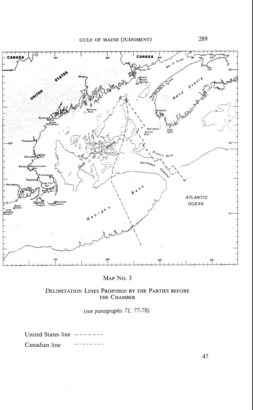
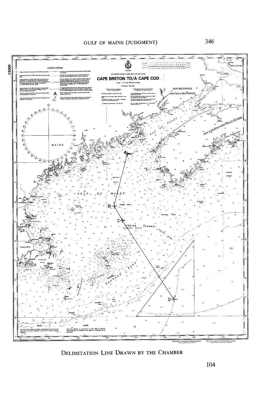
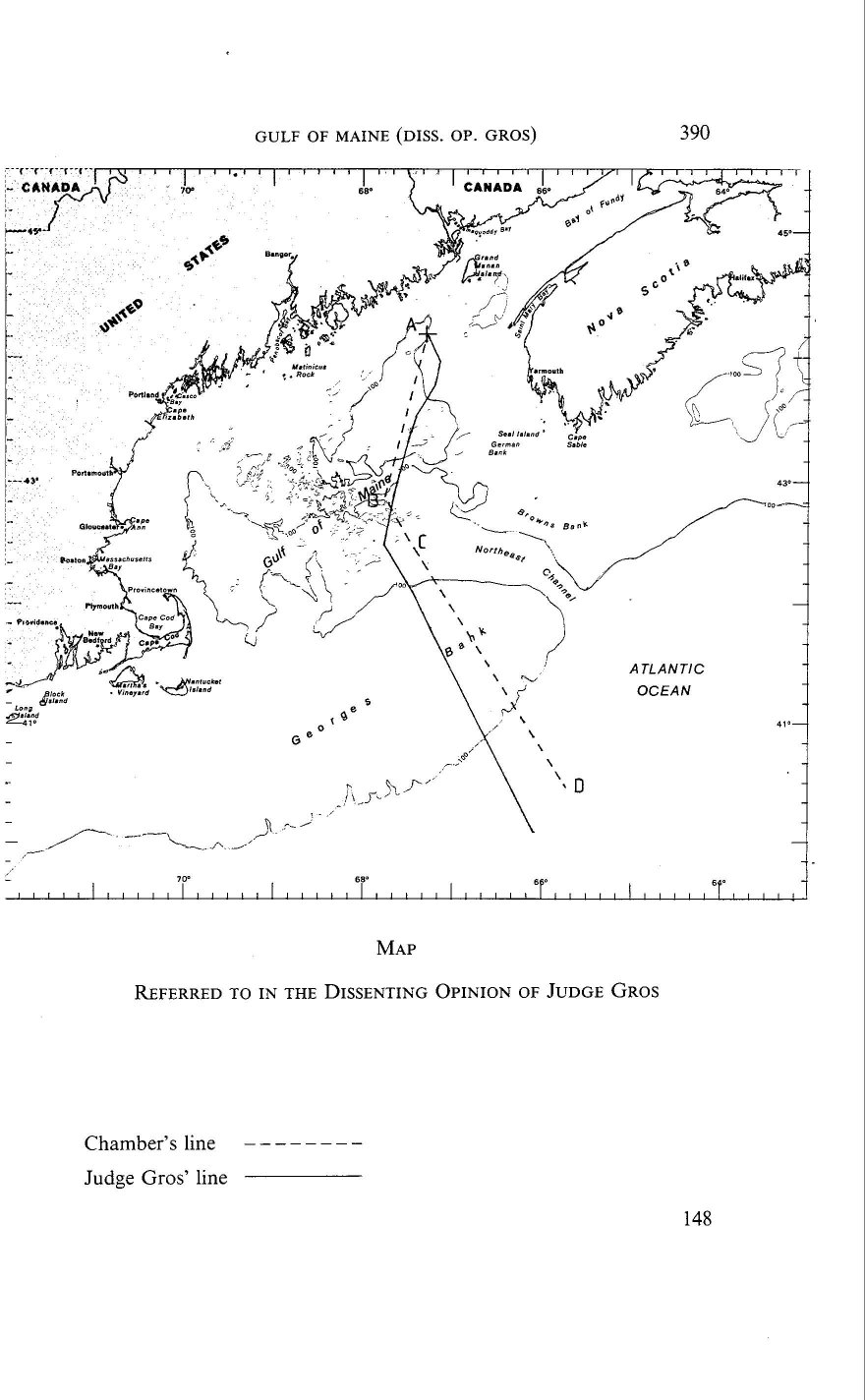